National Weather Service
|
|
|
- Grant Ferguson
- 5 years ago
- Views:
Transcription
1 National Weather Service Performance and Challenges Warning Systems Kenneth E. Graham Meteorologist-in-Charge New Orleans


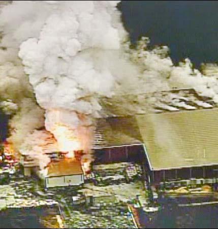
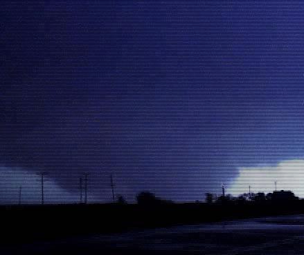
2 Busy 2008 Number of Tornadoes Number of Tornado Fatalities *Preliminary So Far This Year * * Greensburg, KS
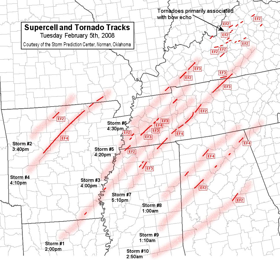
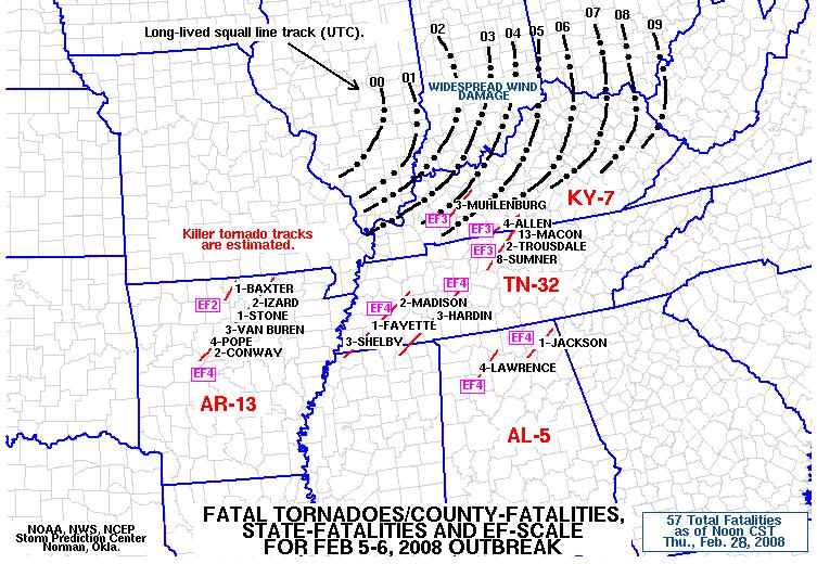
3 Super Tuesday February 5 through 6, 2008: 82 tornadoes including 5 EF4s 57 fatalities; most since May 31 st, 1985 and 13 th all time 350+ injuries > 400M in property damage 36 (63%) killed were in mobile homes Most of the tornadoes occurred after dark
4 Super Tuesday Even with advanced notice of the event and individual severe storms, there was still a large loss of life

5 Communication Prior to Outbreak SPC Day 6 Severe Thunderstorm Outlook Issued: Jan. 30, 2008 Valid: Feb 5-6, 2008 Tornado, Wind, Hail Reports NWS began publicizing the potential for severe weather 6 days in advance of the outbreak.


6 Communication Prior to Outbreak Hatched area depicts the potential for significant EF2-EF5 tornadoes. Day 3 Severe Thunderstorm Outlook Issued: Sun (2am), Feb 3. Valid: Feb 5-6 Day 1 Tornado Probability Issued and Valid Tue, Feb 5 NWS forecasts were further refined leading up to February 5, 2008
7 Communication Prior to Outbreak NWS Weather Forecast Offices (WFOs) advertised the potential for severe thunderstorms, including tornadoes, in their Hazardous Weather Outlooks (HWOs) as early as Thursday, January 31, Subsequent HWOs throughout the weekend refined the timing and magnitude of the threat. WFOs used conference calls, Go-To Meeting, /text alerts, and graphical HWOs to provide situational awareness. WFOs used IEM Chat and 800MHz to communicate with media and emergency manager partners.
8 Warning Lead Time Performance: Average lead time for tornado warnings was 18 minutes (17 minutes for tornadoes causing fatalities)

9 What Happened?

10 What Happened?
11
12

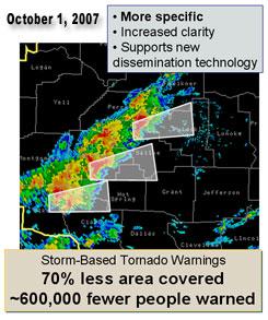
13 Storm Based Warnings Previously
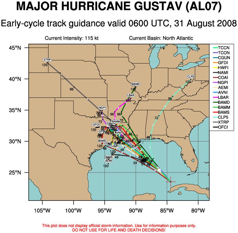
14 Hurricane Season 2008 Tropical Storm Arthur Hurricane Bertha Tropical Storm Cristobal Hurricane Dolly Tropical Storm Edouard Tropical Storm Fay Hurricane Gustav Hurricane Hanna Hurricane Ike Tropical Storm Josephine

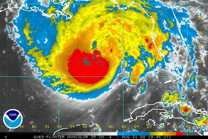
15 Storm Surge Bay St. Louis, MS
16 Communicating Impacts Routine Becomes Extreme Text Products Graphical Products Statements Discussions Stand-Alone Daily Forecast Impact Statements Live Go-To Meetings Briefings Press Conference Stand-By Life or Death
17 Communicating Impacts The following slides are the actual slides used during a situational awareness presentation
18 Communicating Impacts

19 Gustav Storm Surge
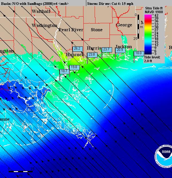
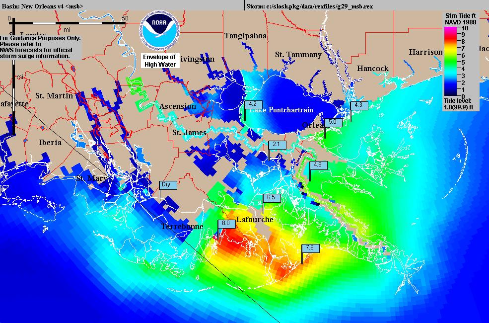
20 Communicating Impacts
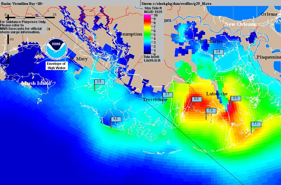
21 Communicating Impacts
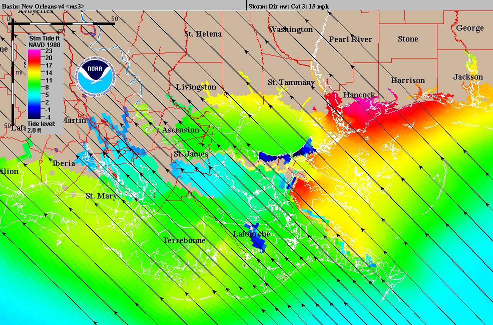
22 Communicating Impacts

23 Communicating Impacts The following slides are the actual slides we used during a situational awareness presentation
24 Communicating Impacts
25 Communicating Impacts
26 Communicating Impacts
27 Gustav SLOSH estimate using 50 nm RMW

28 Gustav estimate if ~ 10 knots stronger


29 Note that only 10 knots makes the difference between west bank communities dry or wet Faster Slower
30 Single Track Storm Surge Plot
31 Single Track Storm Surge Plot (moved track west)

32 Single Track Storm Surge Plot (moved track east)

33 Multiple Track Storm Surge Plot
34 Communicating Impacts
35 Communicating Impacts Time Event* 0300 Internal Coordination 0700 Governor Briefing 0800 SE Parish Task Force 0900 Internal Coordination 1000 New Orleans FEB 1100 MS Counties Briefing 1500 Internal Coordination 1600 SE Parish Task Force 1700 New Orleans FEB 1800 Governor Briefing *Does not include briefings on demand, press conferences, or media interviews
36 Future Improvements Improving Services for Future: Radar Advancements Super Resolution Doppler Radar Dual-Polarization Radars Phased Array Radar Warning Dissemination Common Alerting Protocol (CAP) Cell Phone Reverse 911 In Car Information GIS Storm Decision Aids Uncertainty Communication
37 Future Improvements Improving Services for Future: Hurricane Forecast Improvement Research Intensity Track Storm Surge


38 Future Improvements PAR PAR Advancements In Radar Technology Phased Array compared to WSR-88D KTLX KTLX
39 Future Improvements Improved Social Science Integration WAS*IS Strong Emergency Management Ties Target Those At Risk Continue Strong Partnerships Related to NOAA Weather Radio Transmitters Receivers Weather Radio Improvement Project (WRIP)


40 Continue to Grow Our All Hazards Partnership Incident Support
41
Charles Kuster Leadville, CO. Personal Overview
 Charles Kuster Leadville, CO Personal Overview Personal Overview Charles Kuster Leadville, CO OU to study meteorology Charles Kuster Leadville, CO Personal Overview OU to study meteorology Graduated in
NOAA s National Weather Service. National Weather Service
 NOAA s National Weather Service Serving the Nation s Environmental Forecasting Needs Lynn Maximuk Regional Director National Weather Service Central Region Headquarters Kansas City, Missouri America s
TROPICAL CYCLONE TORNADOES
 TROPICAL CYCLONE TORNADOES 2018 GOVERNOR S HURRICANE CONFERENCE TUESDAY, MAY 15, 2018 WILL ULRICH NWS FORECAST OFFICE MELBOURNE WHERE ARE THE TORNADOES? WHERE ARE THE TORNADOES? C B A WEST MELBOURNE, FL
Building a Weather Ready Nation: Linking Impact Based Decision Support Services to Observations, Forecasts, Warnings & Dissemination
 Building a Weather Ready Nation: Linking Impact Based Decision Support Services to Observations, Forecasts, Warnings & Dissemination Dr. Louis W. Uccellini Director, NOAA Assistant Administrator for Weather
The Wind Hazard: Messaging the Wind Threat & Corresponding Potential Impacts
 The Wind Hazard: Messaging the Wind Threat & Corresponding Potential Impacts Scott Spratt Warning Coordination Meteorologist NWS Melbourne, FL David Sharp Science & Operations Officer NWS Melbourne, FL
El Niño Update Impacts on Florida
 Current Issues in Emergency Management (CIEM) Sessions 1 &2 October 12 th and 26 th, 2006 Florida Division of Emergency Management Tallahassee, Florida El Niño Update Impacts on Florida Bart Hagemeyer
United States Multi-Hazard Early Warning System
 United States Multi-Hazard Early Warning System Saving Lives Through Partnership Lynn Maximuk National Weather Service Director, Central Region Kansas City, Missouri America s s Weather Enterprise: Protecting
2008 Hurricane Caravan. Daniel Noah Meteorologist National Weather Service x1 May 22, 2008
 2008 Hurricane Caravan Daniel Noah Meteorologist National Weather Service daniel.noah@noaa.gov, 813-645-2323 x1 May 22, 2008 National Weather Service We never close! Open 24 hours a day 365 days per year
Coordinated Safety Messaging: An Integrated Approach. Matt Moreland FLGHC: Effective Messaging and Decision Support Services May 16, 2017
 Coordinated Safety Messaging: An Integrated Approach Matt Moreland FLGHC: Effective Messaging and Decision Support Services May 16, 2017 Question According to most meteorologists, how long should a weather
Impact Based Warning Tornado - Infrastructure
 National Weather Service Impact Based Warning Tornado - Infrastructure Jim Kramper Warning Coordination Meteorologist St. Louis, MO NOAA s National Weather Service 2011 was a devastating year for tornado
Unit 5: NWS Hazardous Weather Products. Hazardous Weather and Flooding Preparedness
 Unit 5: NWS Hazardous Weather Products Objectives Describe the mission of the NWS Describe the basic organizational structure of the NWS Explain the purpose of various NWS products Explain how Probability
50 th Anniversary of the Oak Lawn Tornado
 50 th Anniversary of the Oak Lawn Tornado 2017 DuPage County Advanced Severe Weather Seminar National Weather Service Chicago Mike Bardou Stephen Rodriguez Outline 1967 Belvidere, Lake Zurich, and Oak
Thunderstorm Forecasting and Warnings in the US: Applications to the Veneto Region
 Thunderstorm Forecasting and Warnings in the US: Applications to the Veneto Region Bill Conway Vice President Weather Decision Technologies Norman, Oklahoma, USA Andrea Rossa ARPAV Lead Scientist Centre
Canadian Hurricane Center: How NHC Products are used to issue Warnings and Communicate Hazards
 Canadian Hurricane Center: How NHC Products are used to issue Warnings and Communicate Hazards Bob Robichaud Warning Preparedness Meteorologist Canadian Hurricane Centre Contents Brief background on the
NWS HURRICANES June 3, 2015
 NWS HURRICANES June 3, 2015 Hurricane Season June 1 November 30 2 What s the concern? All tropical systems passing within 125nm of central Maryland since 1950 Mid-Atlantic Hurricanes Greatest Risk: August
El Niño & Expected Florida Severe Weather
 El Niño & Expected Florida Severe Weather Brady Smith, AICP, CFM Tampa Bay Regional Planning Council brady@tbrpc.org ONE BAY Resilient Communities Working Group Meeting February 5, 2016 El Niño & Expected
Frank Revitte National Weather Service. Weather Forecast Office New Orleans/Baton Rouge
 Frank Revitte National Weather Service Weather Forecast Office New Orleans/Baton Rouge Above normal activity 17 Total Named Storms 7 Tropical Storms 4 Hurricanes 6 Major Hurricanes Not the most active,
We Had No Warning An Overview of Available Forecast Products Before and During Severe Weather Events
 We Had No Warning An Overview of Available Forecast Products Before and During Severe Weather Events Two main sources for severe weather info NOAA/NWS Storm Prediction Center (SPC) Convective Outlooks
THE IMPACT OF WEATHER
 The United States is the most severe weather prone country in the world. Each year, people in this country cope with an average of 10,000 thunderstorms, 5,000 floods, 1,200 tornadoes and two landfalling
Complete Weather Intelligence for Public Safety from DTN
 Complete Weather Intelligence for Public Safety from DTN September 2017 White Paper www.dtn.com / 1.800.610.0777 From flooding to tornados to severe winter storms, the threats to public safety from weather-related
Communicating Hurricane Threats and Impacts on a National Scale. Daniel Brown Warning Coordination Meteorologist National Hurricane Center
 Communicating Hurricane Threats and Impacts on a National Scale Daniel Brown Warning Coordination Meteorologist National Hurricane Center New NWS Products to Help Communicate Potential Impacts New probabilistic
Severe Weather Hazards Are Real
 Severe Weather Hazards Are Real In the past 10 years, more than 40 people have died and dozens more injured as a result of weatherrelated events in Minnesota (not including motor vehicles.) The top severe
California OES Weather Threat Briefing
 California OES Weather Threat Briefing Wednesday, January 16, 2019 9:00 AM PST Day 1: Strong winds, heavy mountain snow and heavy rain with isolated thunderstorms across much of the state through Thursday
CASA DFW Urban Demonstration Network
 CASA DFW Urban Demonstration Network Cedar League, University of Colorado Colorado Springs Brenda Philips University of Massachusetts Integrated Warning Team Meeting March 6, 2013 Cutting Edge Radars for
A HURRICANE IS COMING. Presented by Atiba Upchurch Broward Emergency Management Division
 A HURRICANE IS COMING Presented by Atiba Upchurch Broward Emergency Management Division Mission Statement To safeguard the lives and property of the people of Broward County from major hazards and emergencies
Building A Weather-Ready Nation
 Building A Weather-Ready Nation Steve Runnels National Weather Service Springfield, MO` Photo Credit: Tim Marshall 122 National Weather Service Offices NWS Offices Service Missouri and Warning Coordination
Weather forecasts and warnings: Support for Impact based decision making
 Weather forecasts and warnings: Support for Impact based decision making Gerry Murphy, Met Éireann www.met.ie An Era of Change Climate and weather is changing Societal vulnerability is increasing The nature
The 2014 Atlantic Hurricane Season. What is New and What to Expect. Mark Chambers President & CEO ImpactWeather, Inc.
 The 2014 Atlantic Hurricane Season What is New and What to Expect Mark Chambers President & CEO ImpactWeather, Inc. Hurricane Climatology for the Gulf of Mexico A Look back at 2013 The outlook for this
Daily Operations Briefing Thursday, December 25, :30 a.m. EST
 Daily Operations Briefing Thursday, December 25, 2014 8:30 a.m. EST Significant Activity: Dec 24 25 Significant Events: Severe Weather Southeast (Dec 23 24) Significant Weather: Heavy snow: Intermountain
Preparing For Winter Weather At Home & In The Workplace. Brandon Peloquin, Warning Coordination Meteorologist NWS Wilmington OH
 Preparing For Winter Weather At Home & In The Workplace Brandon Peloquin, Warning Coordination Meteorologist NWS Wilmington OH What We Will Talk About Introduction to the National Weather Service How we
The Local Wind Forecast and Its Uncertainty (Completing the Wind Forecast)
") The Local Wind Forecast and Its Uncertainty (Completing the Wind Forecast) Florida Governor Hurricane Conference May 11-16 2014 Pablo Santos Meteorologist In Charge NWS Miami/South Florida Forecast Office
The Local Wind Forecast and Its Uncertainty (Completing the Wind Forecast) Florida Governor Hurricane Conference May 11-16 2014 Pablo Santos Meteorologist In Charge NWS Miami/South Florida Forecast Office
2017 Hurricane Season and Beyond
 2017 Hurricane Season and Beyond Ken Graham National Hurricane Center Building a Weather-Ready Nation Much of U.S. Coast Saw Tropical Wind Watches or Warnings 2017 Hurricane Season Facts and Figures 7th
NWS Resources For Public Works
 NWS Resources For Public Works August 28th, 2016 Shawn DeVinny shawn.devinny@noaa.gov Meteorologist National Weather Service Twin Cities/Chanhassen, MN 1 APWA 2016 PWX 8/28/2016 National Weather Service
Active Weather Threat Halloween Week Nor easter October 28 th 31 st 2012
 Active Weather Threat Halloween Week Nor easter October 28 th 31 st 2012 Prepared 1130 AM EDT Wednesday, October 24, 2012 Gary Szatkowski NOAA s NJ Forecast Office Weather.gov/phi Purpose of Briefing Briefing
Winter Weather. National Weather Service Buffalo, NY
 Winter Weather National Weather Service Buffalo, NY Average Seasonal Snowfall SNOWFALL = BIG IMPACTS School / government / business closures Airport shutdowns/delays Traffic accidents with injuries/fatalities
Building a Weather-Ready Nation For Aviation
 Building a Weather-Ready Nation For Aviation Laura Furgione NOAA Deputy Assistant Administrator for Weather Services Friends and Partners in Aviation Weather July 22, 2014 Case for Change Average Year
Tropical Weather Briefing
 Tropical Weather Briefing August 28, 2012 700 AM CDT National Weather Service Weather Forecast Office Slidell, LA Current Satellite Tropical Storm Isaac Watches/Warnings Tropical Storm Isaac Track Guidance
FLOOD/SCS EVENT, APRIL 28 MAY 4
 REPORT DATE: May 4, 2017 EVENT DATE: April 28-May 4, 2017 FLOOD/SCS EVENT, APRIL 28 MAY 4 Event Summary General Significant Flood Outlook. SOURCE: National Weather Service. A significant severe thunderstorm
A Preliminary Severe Winter Storms Climatology for Missouri from
 A Preliminary Severe Winter Storms Climatology for Missouri from 1960-2010 K.L. Crandall and P.S Market University of Missouri Department of Soil, Environmental and Atmospheric Sciences Introduction The
13.2 USING VIRTUAL GLOBES TO IMPROVE SITUATIONAL AWARENESS IN THE NATIONAL WEATHER SERVICE
 13.2 USING VIRTUAL GLOBES TO IMPROVE SITUATIONAL AWARENESS IN THE NATIONAL WEATHER SERVICE Andy Foster* National Weather Service Springfield, Missouri* Keith Stellman National Weather Service Shreveport,
Daily Operations Briefing Tuesday, April 4, :30 a.m. EDT
 Daily Operations Briefing Tuesday, April 4, 2017 8:30 a.m. EDT Significant Activity Apr 3-4 Significant Events: Severe Weather Southern Plains to Southeast Significant Weather: Severe Thunderstorms and
Hurricane Matthew. National Weather Service Wilmington NC. Steven Pfaff, WCM.
 Hurricane Matthew Threat Assessment for northeast South Carolina & southeast North Carolina National Weather Service Wilmington NC 730 AM EDT Tuesday October 4, 2016 Steven Pfaff, WCM Steven.Pfaff@noaa.gov
Our Challenge. It s All Wind 2/16/2017
 2/16/2017 It s All Wind Communicating Damaging Wind & Tornado Threats in an Impact-based Environment Rick Smith - NWS Norman, OK Justin Dougherty Our Challenge Given the history and types of weather threats
Situation Manual Protective Actions
 Situation Manual Protective Actions 175 Minutes Situation Manual Tabletop Exercise 1 Disaster Resistant Communities Group www.drc-group.com Tallahassee Twister Start Exercise No Image During the exercise
MET Lecture 29 Tornadoes IV
 MET 4300 Lecture 29 Tornadoes IV Outline Definition, life cycle, & climatology of tornadoes Tornado formation within supercells Tornado formation within nonsupercell thunderstorms Fujita scale Tornado
ovember 2008 Antigua and Barbuda Meteorological Service
 ovember 2008 Antigua and Barbuda Meteorological Service The Atlantic Hurricane Season Summary 2008 Special Focus on Antigua and Barbuda The Season in Brief Sixteen (16) named storms formed in the Atlantic
NWS Resources For School Districts
 NWS Resources For School Districts January 23rd, 2017 Shawn DeVinny shawn.devinny@noaa.gov Meteorologist National Weather Service Twin Cities/Chanhassen, MN Outline Watches/Warnings/Advisories Example
Daily Operations Briefing Wednesday, February 8, :30 a.m. EST
 Daily Operations Briefing Wednesday, February 8, 2017 8:30 a.m. EST Significant Activity Feb 7-8 Significant Events: Severe weather/tornadoes - Louisiana Significant Weather: Freezing rain possible Pacific
Advanced Spotter Training Welcome! Lesson 1: Introduction and Why Spotters are Important
 Advanced Spotter Training 2009 Welcome! Lesson 1: Introduction and Why Spotters are Important Introduction This course is intended to advance the basic training given by the National Weather Service (NWS).
Tropical Update. 5 AM EDT Tuesday, September 12, 2017 Post-Tropical Cyclone Irma, Hurricane Jose, & Tropical Wave (10%)
") Tropical Update 5 AM EDT Tuesday, September 12, 2017 Post-Tropical Cyclone Irma, Hurricane Jose, & Tropical Wave (10%) This update is intended for government and emergency response officials, and is provided
Tropical Update 5 AM EDT Tuesday, September 12, 2017 Post-Tropical Cyclone Irma, Hurricane Jose, & Tropical Wave (10%) This update is intended for government and emergency response officials, and is provided
Review of Basic Severe Thunderstorm & Tornado Spotting Concepts. Jim Allsopp National Weather Service Chicago/Romeoville, IL
 Review of Basic Severe Thunderstorm & Tornado Spotting Concepts Jim Allsopp National Weather Service Chicago/Romeoville, IL Why Do We Need Spotters? Radar has limitations, only spotters can provide view
Daily Operations Briefing. Wednesday, August 23, :30 a.m. EDT
 Daily Operations Briefing Wednesday, August 23, 2017 8:30 a.m. EDT Significant Activity August 22-23 Significant Events: Tropical Weather Threat Gulf Coast Tropical Activity: Atlantic Disturbance 1 High
National Weather Service
 National Weather Service Integrated Warning Team Workshops: NWS Warnings and Outdoor Warning Sirens Tim Halbach Warning Coordination Meteorologist Milwaukee NWS Integrated Warning Team NWS State Officials
National Hurricane Center Products. Jack Beven National Hurricane Center
 National Hurricane Center Products Jack Beven National Hurricane Center Florida Governor s Hurricane Conference 11 May 2014 NHC Tropical Cyclone Products NHC provides the big picture that complements and
TROPICAL STORM HARVEY BRIEFING
 TROPICAL STORM HARVEY BRIEFING 10:00 AM CDT Sunday, August 27, 2017 Prepared by: NWS LIX NWSNewOrleans www.weather.gov/neworleans Situation Overview New Information Tropical Storm Winds 40mph Immediate
10 years after Hurricane Charley
 10 years after Hurricane Charley Hurricane Charley (2004) A Retrospective Scott M. Spratt Warning Coordination Meteorologist NWS Melbourne, FL Florida Governors Hurricane Conference May 15, 2014 11 AM
4 Forecasting Weather
 CHAPTER 16 4 Forecasting Weather SECTION Understanding Weather BEFORE YOU READ After you read this section, you should be able to answer these questions: What instruments are used to forecast weather?
Key Takeaways: - Rain: Coastal NC: ; isolated totals to 40 Central, Western, & Northeastern NC: 5-10 ; isolated totals to 20
 Key Takeaways: - Life-Threatening Impacts Will Extend Far From The Storm s Center: Despite the southward shift in track, widespread and extreme impacts from heavy rain, storm surge, and wind are still
Tropical Update. 11 AM EDT Tuesday, October 9, 2018 Hurricane Michael, Tropical Storm Leslie, Tropical Storm Nadine
 Tropical Update 11 AM EDT Tuesday, October 9, 2018 Hurricane Michael, Tropical Storm Leslie, Tropical Storm Nadine This update is intended for government and emergency response officials, and is provided
The Nuts and Bolts of These Community Preparedness Recognition Programs
 The Nuts and Bolts of These Community Preparedness Recognition Programs Bill Sammler Warning Coordination Meteorologist NOAA s National Weather Service, Wakefield VA http://weather.gov/akq Why is StormReady
 Hazard Warnings GE 4150 Natural Hazards September 17, 2007 http://www.sdr.gov/ndis_rev_oct27.pdf Sorensen, J.H. (2000) Hazard warning systems: Review of 20 years of progress. Natural Hazards Review, May,
Tornado Safety: 2013 Practical Steps for Weather-Related Emergencies
 Tornado Safety: 2013 Practical Steps for Weather-Related Emergencies Campbell County Public Safety One County, One Mission, One Call Away Tornado Preparedness Day March 12, 2013 As 62 tornadoes struck
Daily Operations Briefing Thursday, April 6, :30 a.m. EDT
 Daily Operations Briefing Thursday, April 6, 2017 8:30 a.m. EDT Significant Activity Apr 5-6 Significant Events: Severe Weather Southeast and Mid-Atlantic Significant Weather: Severe thunderstorms possible
TORNADO PREPAREDNESS AND INFORMATION MANUAL
 TORNADO PREPAREDNESS AND INFORMATION MANUAL What is a Tornado? A tornado is defined as a violently rotating column of air extending from a thunderstorm to the ground. The most violent tornadoes are capable
The 2015 NWS Spring and Summer Weather Update
 http://weather.gov The 2015 NWS Spring and Summer Weather Update Western North Carolina severe weather climatology Tony Sturey, WCM Greenville/Spartanburg, SC North Carolina Spring and Summer Outlooks
VISIT MISSISSIPPI GULF COAST CRISIS COMMUNICATION MANUAL 2016
 VISIT MISSISSIPPI GULF COAST CRISIS COMMUNICATION MANUAL 2016 This manual was prepared for Visit Mississippi Gulf Coast staff in the event of a crisis, and will help to distinguish the appropriate course
UDOT Weather Program Traffic Operations Center
 UDOT Weather Program Traffic Operations Center Presentation Goals You MUST account for weather in your Traffic Management program Provide you with information on proven tools and strategies You NEED a
Daily Operations Briefing. Monday, April 2, :30 a.m. EDT
 Daily Operations Briefing Monday, April 2, 2018 8:30 a.m. EDT Significant Activity Mar 31-April 2 Significant Events: None Tropical Activity: No significant activity Significant Weather: Heavy Snow Northern
2013 Tornado and Severe Weather Awareness Drill
 2013 Tornado and Severe Weather Awareness Drill Scheduled for Thursday April 18, 2013 The 2013 Tornado Drill will consist of a mock tornado watch and a mock tornado warning for all of Wisconsin. This is
The Joplin Tornado: Lessons Learned from the NIST Investigation
 February 4, 2014 AMS Annual Meeting The Joplin Tornado: Lessons Learned from the NIST Investigation Franklin T. Lombardo, NIST Erica Kuligowski, NIST Marc Levitan, NIST Long Phan, NIST David Jorgensen,
A Complex Weather System: Tuesday Afternoon into Thursday March 3 5, 2015
 A Complex Weather System: Tuesday Afternoon into Thursday March 3 5, 2015 Briefing #1, prepared 900 AM EST Tuesday, March 3, 2015 by Meteorologists at NWS - WFO Mount Holly, NJ To promote situational awareness
Building a Weather-Ready Wisconsin
 National Weather Service Session: Building a Weather-Ready Wisconsin WEMA Conference October 11, 2017 Jeff Last National Weather Service Green Bay Today s Presentation NWSChat in EM Operations The June
Daily Operations Briefing Wednesday, April 5, :30 a.m. EDT
 Daily Operations Briefing Wednesday, April 5, 2017 8:30 a.m. EDT Significant Activity Apr 4-5 Significant Events: Severe Weather Southern Plains to Southeast Significant Weather: Severe thunderstorms &
PUBLIC SAFETY POWER SHUTOFF POLICIES AND PROCEDURES
 PACIFIC GAS AND ELECTRIC COMPANY PUBLIC SAFETY POWER SHUTOFF POLICIES AND PROCEDURES SEPTEMBER 2018 1 PACIFIC GAS AND ELECTRIC COMPANY PUBLIC SAFETY POWER SHUTOFF POLICIES AND PROCEDURES SEPTEMBER 2018
Communications and Lessons Learned from
 Weather Forecast Office Charleston, SC Communications and Lessons Learned from Southeast and Caribbean and Climate Community of Practice - April, 2017 Public Information and Communications During Extremes
The Joplin Tornado: Lessons Learned from the NIST Investigation
 February 4, 2014 AMS Annual Meeting The Joplin Tornado: Lessons Learned from the NIST Investigation Franklin T. Lombardo, NIST/RPI Erica Kuligowski, NIST Marc Levitan, NIST Long Phan, NIST David Jorgensen,
Extreme Temperature Protocol in Middlesex-London
 Clean Air Partnership Webinar March 17, 2009 Extreme Temperature Protocol in Middlesex-London Presented by Iqbal Kalsi, MBA, CPHI(C), CCEP iqbal.kalsi@mlhu.on.ca 1 History Informal monitoring, tracking
National Weather Service. Building a Weather Ready Nation
 National Weather Service Building a Weather Ready Nation The NWS is a federal agency Department of Commerce National Oceanic and Atmospheric Administration National Weather Service Today s National Weather
WHAT HAPPENS WHEN A TORNADO STRIKES THE COMMUNITY? Carroll County Sheriff s Office Emergency Management
 WHAT HAPPENS WHEN A TORNADO STRIKES THE COMMUNITY? Carroll County Sheriff s Office Emergency Management WHAT IS EMERGENCY MANAGEMENT? Carroll County Sheriff s Office Emergency Management Agency is responsible
Tropical Update. 11 AM EDT Wednesday, October 10, 2018 Hurricane Michael, Hurricane Leslie & Tropical Storm Nadine, Caribbean Low (40%)
") Tropical Update 11 AM EDT Wednesday, October 10, 2018 Hurricane Michael, Hurricane Leslie & Tropical Storm Nadine, Caribbean Low (40%) This update is intended for government and emergency response officials,
Tropical Update 11 AM EDT Wednesday, October 10, 2018 Hurricane Michael, Hurricane Leslie & Tropical Storm Nadine, Caribbean Low (40%) This update is intended for government and emergency response officials,
Are You Ready For Hurricane Season? 2018 Hurricane Talk B Y : S T O R M T E A M 8 M E T E O R O L O G I S T J U L I E P H I L L I P S
 Are You Ready For Hurricane Season? 2018 Hurricane Talk B Y : S T O R M T E A M 8 M E T E O R O L O G I S T J U L I E P H I L L I P S About Me I am Currently a Weekday Meteorologist at WFLA Channel 8.
Severe Thunderstorms
 Severe Thunderstorms Severe Thunderstorms Explain that, while all thunderstorms are dangerous, the National Weather Service (NWS) defines a severe thunderstorm as one that: Display Slide Th-0 Produces
Significant Flooding Expected
 Significant Flooding Expected Decision Support Briefing #5 As of: 9:00 AM September 14, 2018 What Has Changed? Flash Flood Watch now in effect for part of area, will be expanded later today 9/14/2018 9:23
3A.6 ANALYSIS OF DATA FROM THE 2008 SUPER TUESDAY SEVERE WEATHER OUTBREAK: AN ARKANSAS PERSPECTIVE
 3A.6 ANALYSIS OF DATA FROM THE 2008 SUPER TUESDAY SEVERE WEATHER OUTBREAK: AN ARKANSAS PERSPECTIVE Christopher C. Buonanno* John A. Lewis III NOAA/NWS Little Rock AR 1. INTRODUCTION The Super Tuesday Severe
Hurricane Isaac. National Weather Service. Communication Challenges and The Future. Weather Forecast Office New Orleans/Baton Rouge
 Hurricane Isaac Communication Challenges and The Future National Weather Service Weather Forecast Office New Orleans/Baton Rouge Hurricane Isaac Challenges 2012 Tropical Season Season was quiet for Louisiana
EMERGENCY WARNING SYSTEM PROCEDURES FOR DEBRIS FLOWS IN WESTERN OREGON
 EMERGENCY WARNING SYSTEM PROCEDURES FOR DEBRIS FLOWS IN WESTERN OREGON Updated: 12/03/2007 by the Oregon Department of Forestry and the Oregon Department of Geology and Mineral Industries Debris flows
Eastern Shore Weather and Climate. Bill Sammler Warning Coordination Meteorologist National Weather Service Wakefield, VA
 Eastern Shore Weather and Climate Bill Sammler Warning Coordination Meteorologist National Weather Service Wakefield, VA About The NWS The National Weather Service is: A Federal Government Agency Part
National Public Weather and Warning Services in the Swaziland Meteorological Service Dennis S.Mkhonta /
 National Public Weather and Warning Services in the Swaziland Meteorological Service Dennis S.Mkhonta dennis.mkhonta@gmail.com / dennis@swazimet.gov.sz Introduction Swaziland s geographical position exposes
Hazardous Weather and Flooding Preparedness. Hazardous Weather and Flooding Preparedness
 Hazardous Weather and Flooding Preparedness 1 A Cooperative Effort 2 Administrative Information Emergency exits and procedures Location of restrooms Mobile devices Procedure for questions Course materials
3 Severe Weather. Critical Thinking
 CHAPTER 2 3 Severe Weather SECTION Understanding Weather BEFORE YOU READ After you read this section, you should be able to answer these questions: What are some types of severe weather? How can you stay
Daily Operations Briefing Wednesday, March 1, :30 a.m. EST
 Daily Operations Briefing Wednesday, March 1, 2017 8:30 a.m. EST Significant Activity Feb 28-Mar 1 Significant Events: Severe Weather Midwest to East Coast Significant Weather: Severe Thunderstorms Lower
SLOSH New Orleans Basin 2012 Update
 SLOSH New Orleans Basin 2012 Update Michael Koziara Science and Operations Officer National Weather Service Slidell, LA The Basics What is storm surge? What is SLOSH? Details Assumptions Inundation = Storm
Tropical Update. 5 AM EDT Monday, October 8, 2018 Tropical Storm Michael, Tropical Storm Leslie, Invest 92L (10%) & African Tropical Wave (50%)
 & African Tropical Wave (50%)") Tropical Update 5 AM EDT Monday, October 8, 2018 Tropical Storm Michael, Tropical Storm Leslie, Invest 92L (10%) & African Tropical Wave (50%) This update is intended for government and emergency response
Tropical Update 5 AM EDT Monday, October 8, 2018 Tropical Storm Michael, Tropical Storm Leslie, Invest 92L (10%) & African Tropical Wave (50%) This update is intended for government and emergency response
Hurricane Basics and Preparedness. Jim Weyman Director, Central Pacific Hurricane Center Phone Office:
 Hurricane Basics and Preparedness Jim Weyman Director, Central Pacific Hurricane Center Phone Office: 973-5270 james.weyman@noaa.gov United States Hurricane/Typhoon Centers National Hurricane Center, Miami
Hurricane Charley: A Retrospective 2014 Florida Governor s Hurricane Conference
 Hurricane Charley: A Retrospective 2014 Florida Governor s Hurricane Conference 2004 Hurricane Season: Storm Tracks Satellite Images of 2004 Hurricanes Charley Frances Ivan Jeanne Three Hurricanes in Polk
Importance of Technology as part of the NWS New Orleans/Baton Rouge Impact- Based Decision Support Pilot Project
 Importance of Technology as part of the NWS New Orleans/Baton Rouge Impact- Based Decision Support Pilot Project NWS New Orleans Meteorologist-In-Charge: Ken Graham Emergency Response Specialist Team:
Tropical Update. 5 PM EDT Sunday, October 7, 2018 Tropical Storm Michael, Tropical Storm Leslie, & Invest 92L (30%)
") Tropical Update 5 PM EDT Sunday, October 7, 2018 Tropical Storm Michael, Tropical Storm Leslie, & Invest 92L (30%) This update is intended for government and emergency response officials, and is provided
Tropical Update 5 PM EDT Sunday, October 7, 2018 Tropical Storm Michael, Tropical Storm Leslie, & Invest 92L (30%) This update is intended for government and emergency response officials, and is provided
Mark Fox Meteorologist NWS Fort Worth, TX
 Mark Fox Meteorologist NWS Fort Worth, TX Mark Fox Meteorologist NWS Fort Worth, TX What does severe really mean? Heavy Rain? Hail? Flooding? Wind? Lightning? What does severe really mean? Photo: Mike
Daily Operations Briefing Monday, March 13, :30 a.m. EDT
 Daily Operations Briefing Monday, March 13, 2017 8:30 a.m. EDT Significant Activity Mar 10-13 Significant Events: Nor easter Northeastern U.S. March 13-14 Significant Weather: Heavy snow possible Mid-Atlantic