National Park Service Safety Management
|
|
|
- Berniece Lee
- 5 years ago
- Views:
Transcription
1 National Park Service Safety Management Locating Crashes Spatially from the National Park Service Service-wide Traffic Accident Reporting System (STARS) Database By Daniel Van Gilder Federal Highway Administration Eastern Federal Lands Highway Division
2 What is STARS The National Park Service uses an crash reporting system called STARS. The STARS system locates crashes based on a node system employed in the parks. A node is a recognized physical location point (usually an intersection) used as a reference location where US Park Police or Park Rangers reference a crash location. The STARS database stores for each crash the Park, Park Route, the node number, the distance the crash occurred from the node, and the cardinal direction from the crash to the node.
3 Spatially Locating Crashes To locate the crash locations in a GIS System there needed to be a way to geo-locate the crashes. The issues related to that were: Nodes in the parks were never geo-located or referenced to the Park s routes. Nodes are shown on simple maps that are not geo-referenced or to scale.

4 Example Node Map ACADIA National Park
5 This is Node 012A. Note that this node is located on Route 12 and Route 13(beginning)
6 Spatially Locating Crashes To locate the crash locations in a GIS System there needed to be a way to geolocate the crashes. What we did: Nodes in the parks were geo-located by referencing the node location to the Park s Linear Referenced Routes (LRS) Defining the milepost of the Node. Developed automated tools to use the STARS referencing data and the mileposts of the nodes to locate the milepost of the crash
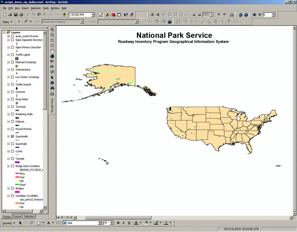
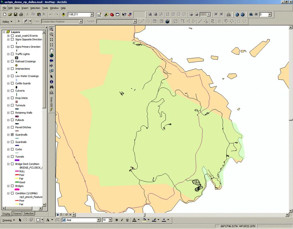
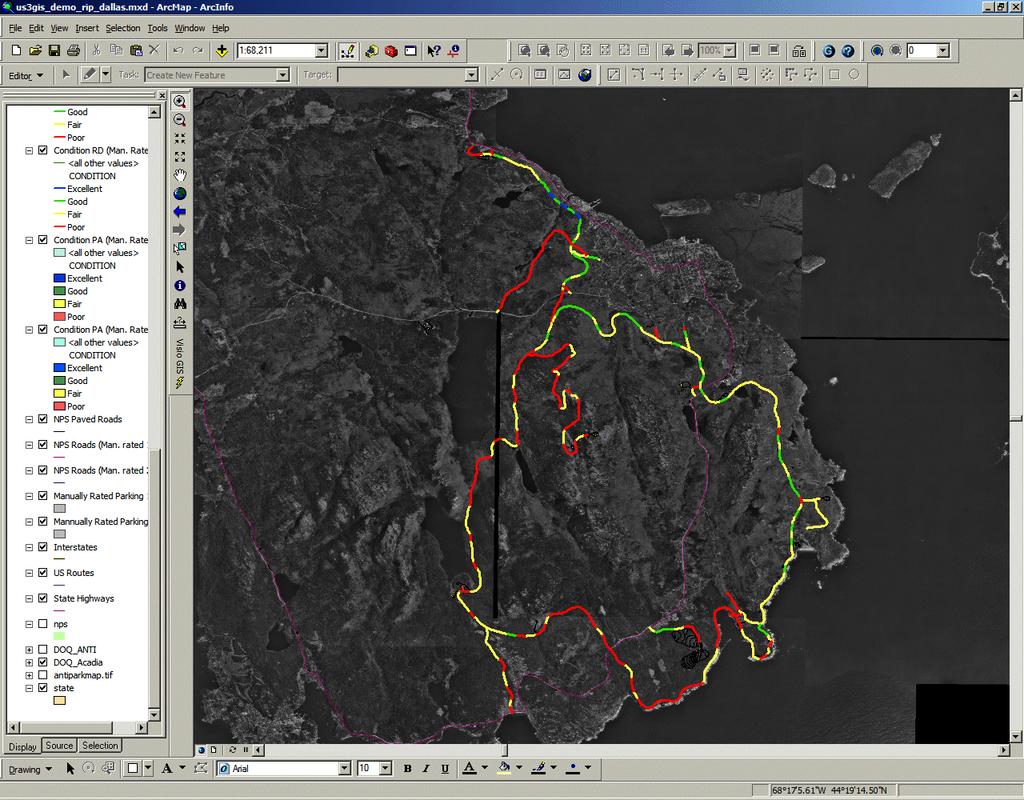
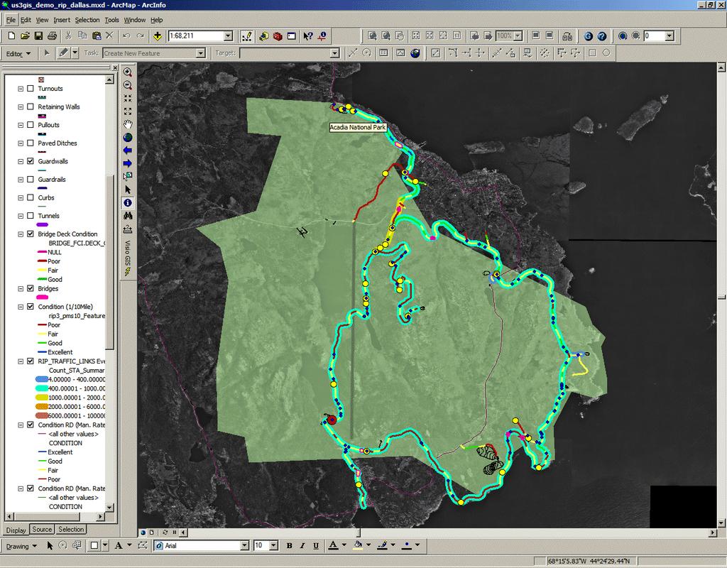
7 Sample of GIS Map Acadia National Park

8 Use the Identify Route Locations Tool Use the Identify Route Locations Tool to define the milepost of Nodes
9 This is Node 012A. Locate this point on the GIS Map and use the Identify Route Location Tool
10 Clicking here provides the results to the left. Note that for Route 12 the milepost is 4.612

11 Clicking on the results table for ACAD-0013 provides that data. The Milepost is 0.00.
12 This is Node 013D. Locate this point on the GIS Map and use the Identify Route Location Tool
13 Clicking here provides the results to the left. Note that for Route 13 the milepost is 1.633
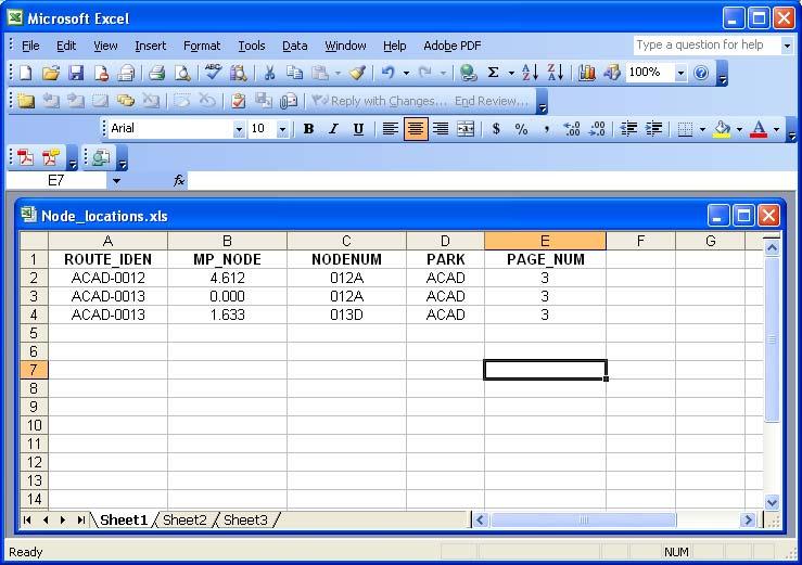
14 Input Data into Spreadsheet/Database

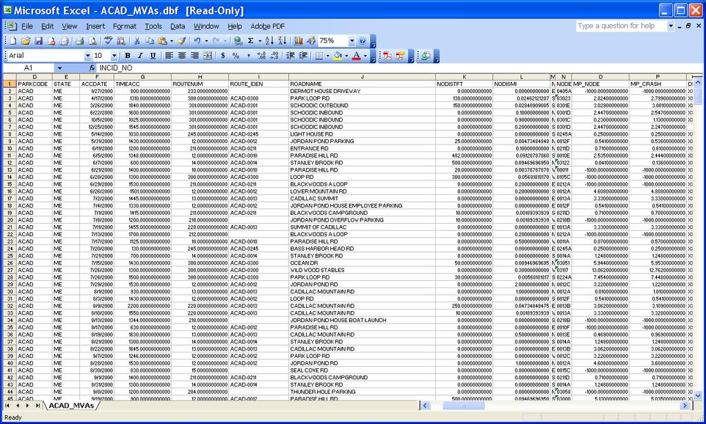
15 STARS DATA ROUTE_IDEN is a field added to the STARS data to help identify which GIS route to use to find the correct node MP_NODE is added to fill in the milepost of the node for the GIS Route and the MP_CRASH is the calculated crash location using the NODEDISMI, NODEDIR fields
16 The highlighted crash reference below shows that the crash occurred on Route ACAD-0012 referencing Node 0012A
17 From the data we see that the crash occurred 0.2 miles from the node. This would yield two possible solutions from the data (0.2 miles north of the node and south of the node)
18 The data also includes a NODEDIR field that says the crash measure is 0.2 miles S or south to the node. So we know the crash occurred to the north of the node so the milepost of the north crash is stored in the MP_CRASH field
19 The GIS automated tool stores the coordinates of the NODE and the two possible solutions (adding and subtracting the NODDISMI value to the NODE milepost value). It then compares the coordinates, and based on the NODEDIR field, the coordinate value solution that satisfies the direction value is determined and the milepost value of that coordinate pair is stored as the milepost value of the MP_CRASH field.

20 Issues with the STARS Data Additional fields are added to the STARS data. The GIS automated tool adds additional fields for the possible solutions and an additional filed named ISSUE. This ISSUE field stores the reason why the GIS tool may not have been able to locate a milepost for the crash. The tool may not have found data stored for the node location in the STARS database and a NODE NOT FOUND issue is stored, or if the GIS Route is not found (a GIS route may not be defined - typically for small routes or parking areas these may not have an LRS route defined) then a ROUTE NOT FOUND issue is stored in the ISSUE field

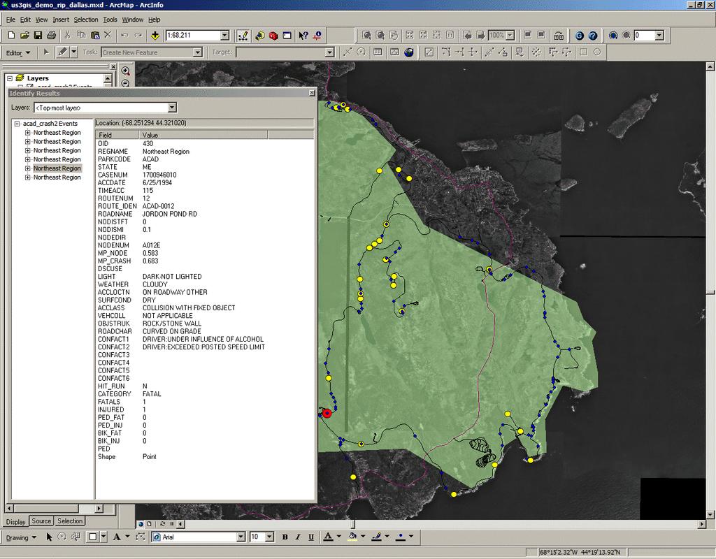
21 Add Data to GIS Event Table Once the STARS data has fields for ROUTE_IDEN and MP_CRASH then the data can be attached to a GIS map as an EVENT TABLE. The EVENT TABLE option is allowed because the NPS Routes are linear referenced so that the table places the crash locations on the route at the milepost stored in the data.
22
23
24
25
26
27
28
29
30
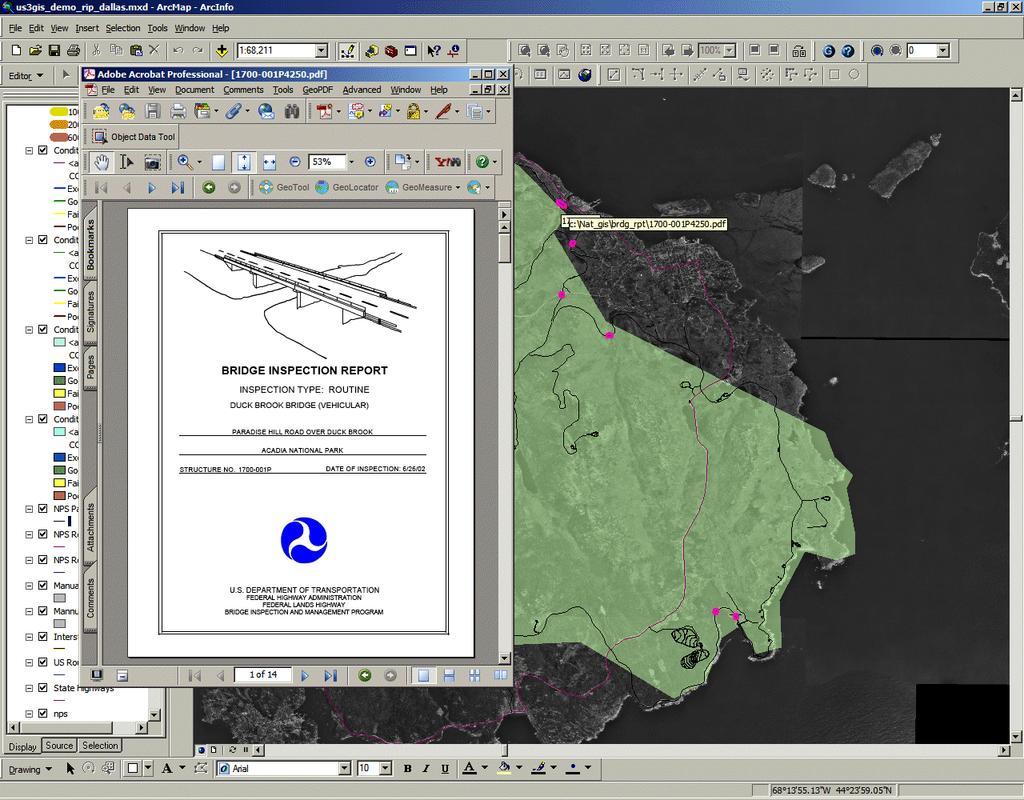
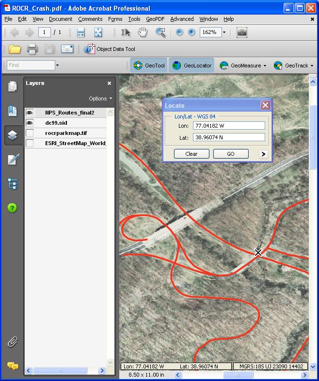
31
32
33
34
35
36 Future Efforts In 2007 a Safety Management Team (NPS and FHWA partnering) was assembled to look at issues with the database and to see if interim fixes could be applied to improve the database Create a single electronic form interface that more closely matched the crash from used in the field. Find a way to store crash locations using longitude and latitude
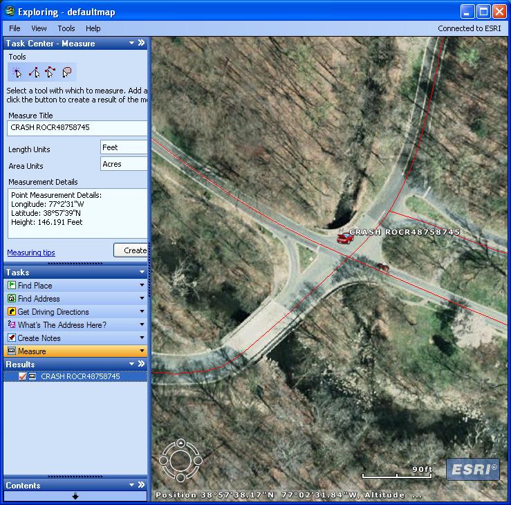
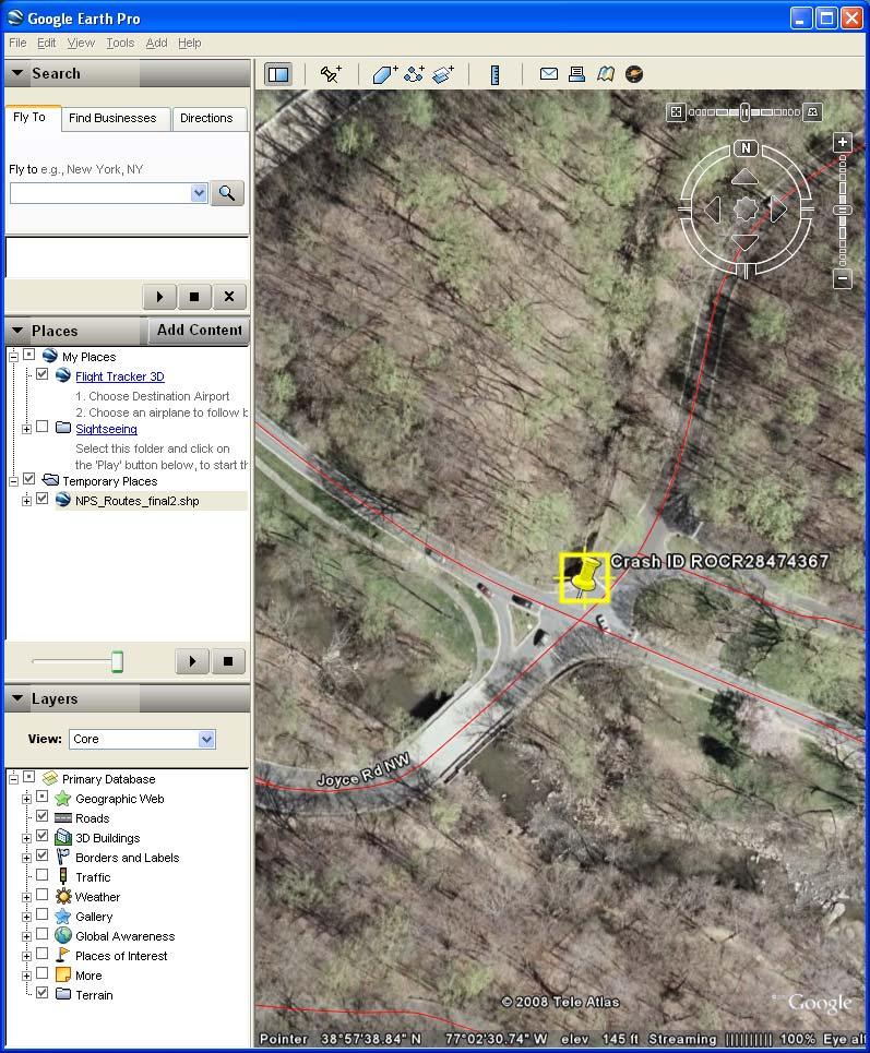
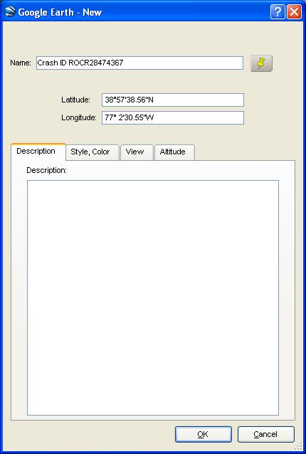
37 Locating Crashes Storing longitude and latitude of the crash was desired but outfitting the entire NPS law enforcement community with GPS would be very expensive were there other options? YES!!

38 Locating Crashes Options for determining Longitude and Latitude of the crash locations: GPS Using mapping software Google Earth GeoPDF ESRI ArcGIS Explorer NPS Internet Mapping Service NPMap
39
40
41

42 Let s look at some of the data and Any Questions?
Enterprise Linear Referencing at the NYS Department of Transportation
 Enterprise Linear Referencing at the NYS Department of Transportation One Highway Network to Support Many Business Processes May 9, 2018 May 9, 2018 2 Agenda An overview of Linear Referencing How NYSDOT
INDOT Office of Traffic Safety
 Intro to GIS Spatial Analysis INDOT Office of Traffic Safety Intro to GIS Spatial Analysis INDOT Office of Traffic Safety Kevin Knoke Section 130 Program Manager Highway Engineer II Registered Professional
NJDOT Pedestrian Safety Analysis Tool 2015 GIS T Conference
 NJDOT Pedestrian Safety Analysis Tool 2015 GIS T Conference NJDOT Pedestrian Safety Analysis Tool Justin Furch GIT Department Manager Michael Baker International Pedestrian Safety in NJ: Has the highest
Landmark LRM. MM and RefPts can be same or different
 1 2 This project began in the fall of 2005. At the time CDOT had three different business units maintaining different LRS s. That is, the beginning and ending reference points and the measured length of
A Summary of State DOT GIS Activities. Presented at the 2000 AASHTO GIS-T Symposium Minneapolis, MN
 A Summary of State DOT GIS Activities Presented at the 2000 AASHTO GIS-T Symposium Minneapolis, MN Information Sources E-mail survey of state DOT GIS managers 49 State DOTs responded in 2000 Results compared
John Laznik 273 Delaplane Ave Newark, DE (302)
") Office Address: John Laznik 273 Delaplane Ave Newark, DE 19711 (302) 831-0479 Center for Applied Demography and Survey Research College of Human Services, Education and Public Policy University of Delaware
Office Address: John Laznik 273 Delaplane Ave Newark, DE 19711 (302) 831-0479 Center for Applied Demography and Survey Research College of Human Services, Education and Public Policy University of Delaware
Linear Referencing Systems (LRS) Support for Municipal Asset Management Systems
 Support for Municipal Asset Management Systems") Linear Referencing Systems (LRS) Support for Municipal Asset Management Systems Esri Canada Infrastructure Asset Management Leadership Forum November 1, 2017 Toronto, ON David Loukes, P. Eng., FEC Andy
Linear Referencing Systems (LRS) Support for Municipal Asset Management Systems Esri Canada Infrastructure Asset Management Leadership Forum November 1, 2017 Toronto, ON David Loukes, P. Eng., FEC Andy
Transforming the Maricopa County Department of Transportation (MCDOT) GIS-based Transportation Asset Inventory System June 30, 2016
 GIS-based Transportation Asset Inventory System June 30, 2016") Transforming the Maricopa County Department of Transportation (MCDOT) GIS-based Transportation Asset Inventory System June 30, 2016 Presented By Steve Hossack, GIS Database Administrator 2016 Esri User
Transforming the Maricopa County Department of Transportation (MCDOT) GIS-based Transportation Asset Inventory System June 30, 2016 Presented By Steve Hossack, GIS Database Administrator 2016 Esri User
Texas A&M University
 Texas A&M University CVEN 658 Civil Engineering Applications of GIS Hotspot Analysis of Highway Accident Spatial Pattern Based on Network Spatial Weights Instructor: Dr. Francisco Olivera Author: Zachry
A Summary of State DOT GIS Activities. Presented at the 2004 AASHTO GIS-T Symposium Rapid City, SD
 A Summary of State DOT GIS Activities Presented at the 2004 AASHTO GIS-T Symposium Rapid City, SD Information Sources E-mail survey of state DOT GIS managers All 51 State DOTs (and DC) responded in 2004
Updating the Urban Boundary and Functional Classification of New Jersey Roadways using 2010 Census data
 Updating the Urban Boundary and Functional Classification of New Jersey Roadways using 2010 Census data By: Glenn Locke, GISP, PMP 1 GIS-T May, 2013 Presentation Overview Purpose of Project Methodology
Adding point data. Account not required
 Adding point data Find patterns in mountains of data You begin to get a strong sense of what maps can do from this lesson. The image shows a total of 58,000 airline routes on one map. The Web Mercator
If you aren t familiar with Geographical Information Systems (GIS), you. GIS, when combined with a database that stores response information,
, you. GIS, when combined with a database that stores response information,") Geographical Information Systems in EMS By William E. Ott If you aren t familiar with Geographical Information Systems (GIS), you should take a look at what GIS can offer you as an EMS manager. GIS, when
Geographical Information Systems in EMS By William E. Ott If you aren t familiar with Geographical Information Systems (GIS), you should take a look at what GIS can offer you as an EMS manager. GIS, when
USING GIS IN WATER SUPPLY AND SEWER MODELLING AND MANAGEMENT
 USING GIS IN WATER SUPPLY AND SEWER MODELLING AND MANAGEMENT HENRIETTE TAMAŠAUSKAS*, L.C. LARSEN, O. MARK DHI Water and Environment, Agern Allé 5 2970 Hørsholm, Denmark *Corresponding author, e-mail: htt@dhigroup.com
Lecture 11. Data Standards and Quality & New Developments in GIS
 Lecture 11 Data Standards and Quality & New Developments in GIS Lecture 11: Outline I. Data Standards and Quality 1. Types of Spatial Data Standards 2. Data Accuracy II. New Developments/The Future of
Lecture 12. Data Standards and Quality & New Developments in GIS
 Lecture 12 Data Standards and Quality & New Developments in GIS Lecture 12: Outline I. Data Standards and Quality 1. Types of Spatial Data Standards 2. Data Accuracy 3. III. Documenting Spatial Data Accuracy
Office of Enterprise Technology
 Office of Enterprise Technology Transforming the Maricopa Department of Transportation (MCDOT) GIS-based Transportation Asset Inventory System January 21, 2016 Presented By Steve Hossack, GIS Database
INTRODUCTION TO GEOGRAPHIC INFORMATION SYSTEM By Reshma H. Patil
 INTRODUCTION TO GEOGRAPHIC INFORMATION SYSTEM By Reshma H. Patil ABSTRACT:- The geographical information system (GIS) is Computer system for capturing, storing, querying analyzing, and displaying geospatial
Generating Thematic Displays for A Simplified Pavement Information and Management System for A Developing Country Using Matlab Application
 Research Journal of Applied Sciences, Engineering and Technology 1(2) 1-5, 2009 ISSN 2040-7467 Maxwell Scientific Organization, 2009 Submit Date April 06, 2009 Accepted Date May 22, 2009 Published Date
Geographical Information Systems
 Geographical Information Systems Geographical Information Systems (GIS) is a relatively new technology that is now prominent in the ecological sciences. This tool allows users to map geographic features
PRIORITIZATION OF ACCIDENT BLACK SPOTS USING GIS
 Website: www.ijetae.com (ISSN 50-59, Volume, Issue 9, September 01) PRIORITIZATION OF ACCIDENT BLACK SPOTS USING GIS Reshma E.K 1, Sheikh Umar Sharif 1 Professor, Student, Civil Engineering Dept., Dayananda
Data Driven Approaches to Crime and Traffic Safety
 Data Driven Approaches to Crime and Traffic Safety Baltimore County Police Department Traffic Safety is Public Safety Baltimore County Police Department Population: 801,000 Square Miles: 610 Sworn Personnel:
Gridded Traffic Density Estimates for Southern
 Gridded Traffic Density Estimates for Southern California, 1995-2014 User Notes authored by Beau, 11/28/2017 METADATA: Each raster file contains Traffic Density data for one year (1995, 2000, 2005, 2010,
THE DEVELOPMENT OF ROAD ACCIDENT DATABASE MANAGEMENT SYSTEM FOR ROAD SAFETY ANALYSES AND IMPROVEMENT
 THE DEVELOPMENT OF ROAD ACCIDENT DATABASE MANAGEMENT SYSTEM FOR ROAD SAFETY ANALYSES AND IMPROVEMENT By T. H. Law Radin Umar R. S. (Road Safety Research Center, Faculty of Engineering, University Putra
ArcGIS Pipeline Referencing An Introduction. Anjali Bhangay William Isley
 ArcGIS Pipeline Referencing An Introduction Anjali Bhangay William Isley Pipeline Referencing Overview Information Model Pipeline Referencing Overview Information Model ArcGIS Pro Pipeline Referencing
What is 511? Need for 511 Services. Development & Deployment of Regional Road and Weather Information Supporting 511 Traveler Services
 Development & Deployment of Regional Road and Weather Information Supporting 511 Traveler Services Leon F. Osborne University of North Dakota Regional Weather Information Center Grand Forks, ND David L.
LRS Task Force June 13, REVISION HISTORY
 North Carolina Department of Transportation Geographic Information Systems (GIS) Unit LINEAR REFERENCING SYSTEM (LRS) PROJECT DEFINITION Version 1.0 REVISION HISTORY Date Document Manager Revision Purpose
Massachusetts Institute of Technology Department of Urban Studies and Planning
 Massachusetts Institute of Technology Department of Urban Studies and Planning 11.520 A Workshop on Geographic Information Systems 11.188 Urban Planning and Social Science Laboratory Fall 2002 Geocoding
Office of Geographic Information Systems
 Office of Geographic Information Systems Print this Page Spring 2009 - Desktop GIS: Dakota County GIS Extensions in ArcMap By Dan Castaneda In the past, the Office of GIS has created desktop extensions
USS Arizona Drawings and Underwater GPS Surveys Linked by ArcIMS
 ESRI UC2004 USS Arizona Drawings and Underwater GPS Surveys Linked by ArcIMS Tim Smith National Park Service Matt Brown Northrop Grumman Information Technology Outline! Introduction! Geodatabase Development!
Applied Cartography and Introduction to GIS GEOG 2017 EL. Lecture-2 Chapters 3 and 4
 Applied Cartography and Introduction to GIS GEOG 2017 EL Lecture-2 Chapters 3 and 4 Vector Data Modeling To prepare spatial data for computer processing: Use x,y coordinates to represent spatial features
INSPIRE Shared Service
 INSPIRE Shared Service Creation and operation out of the box Petra Fritz (HZD), Michael Voigtländer (Esri Deutschland GmbH) INSPIRE Shared Service Agenda HZD backbone for a geodata infrastructure Implementing
Techniques for Science Teachers: Using GIS in Science Classrooms.
 Techniques for Science Teachers: Using GIS in Science Classrooms. After ESRI, 2008 GIS A Geographic Information System A collection of computer hardware, software, and geographic data used together for
DEVELOPMENT OF A VISUALIZATION SYSTEM FOR SafetyAnalyst
 1 2 3 4 5 6 7 8 9 10 11 12 13 14 15 16 17 18 19 20 21 22 23 24 25 26 27 28 29 30 31 32 33 34 35 36 37 38 39 40 41 42 43 DEVELOPMENT OF A VISUALIZATION SYSTEM FOR SafetyAnalyst Alexander Paz, Ph.D., P.E.
Welcome to NR502 GIS Applications in Natural Resources. You can take this course for 1 or 2 credits. There is also an option for 3 credits.
 Welcome to NR502 GIS Applications in Natural Resources. You can take this course for 1 or 2 credits. There is also an option for 3 credits. The 1st credit consists of a series of readings, demonstration,
DEVELOPMENT OF A VISUALIZATION SYSTEM FOR Safety Analyst
 1 2 3 4 5 6 7 8 9 10 11 12 13 14 15 16 17 18 19 20 21 22 23 24 25 26 27 28 29 30 31 32 33 34 35 36 37 38 39 40 41 42 43 44 DEVELOPMENT OF A VISUALIZATION SYSTEM FOR Safety Analyst Alexander Paz, Ph.D.,
How GIS based Visualizations Support Land Use and Transportation Modeling
 How GIS based Visualizations Support Land Use and Transportation Modeling ESRI International Users Conference San Diego, CA - July 23, 2015 Prepared by: Troy Hightower Introduction This presentation will
Steve Pietersen Office Telephone No
 Steve Pietersen Steve.Pieterson@durban.gov.za Office Telephone No. 031 311 8655 Overview Why geography matters The power of GIS EWS GIS water stats EWS GIS sanitation stats How to build a GIS system EWS
Road Ahead: Linear Referencing and UPDM
 Road Ahead: Linear Referencing and UPDM Esri European Petroleum GIS Conference November 7, 2014 Congress Centre, London Your Work Making a Difference ArcGIS Is Evolving Your GIS Is Becoming Part of an
Ohio s Linear Based Referencing System (a.k.a. Location Based Response System LBRS), a True State and Local Government Partnership
, a True State and Local Government Partnership") Ohio s Linear Based Referencing System (a.k.a. Location Based Response System LBRS), a True State and Local Government Partnership Ron Cramer Digital Data Technologies, Inc. Joseph Hausman The Ohio Department
Ohio s Linear Based Referencing System (a.k.a. Location Based Response System LBRS), a True State and Local Government Partnership Ron Cramer Digital Data Technologies, Inc. Joseph Hausman The Ohio Department
GIS (GEOGRAPHIC INFORMATION SYSTEMS)
") GIS (GEOGRAPHIC INFORMATION SYSTEMS) 1 1. DEFINITION SYSTEM Any organised assembly of resources and procedures united and regulated by interaction or interdependence to complete a set of specific functions.
GIS (GEOGRAPHIC INFORMATION SYSTEMS) 1 1. DEFINITION SYSTEM Any organised assembly of resources and procedures united and regulated by interaction or interdependence to complete a set of specific functions.
Applications: Introduction Task 1: Introduction to ArcCatalog Task 2: Introduction to ArcMap Challenge Question References
 CHAPTER 1 INTRODUCTION 1.1 GIS? 1.1.1 Components of a GIS 1.1.2 A Brief History of GIS 1.1.3 GIS Software Products Box 1.1 A List of GIS Software Producers and Their Main Products 1.2 GIS Applications
Arboretum Explorer: Using GIS to map the Arnold Arboretum
 Arboretum Explorer: Using GIS to map the Arnold Arboretum Donna Tremonte, Arnold Arboretum of Harvard University 2015 Esri User Conference (UC), July 22, 2015 http://arboretum.harvard.edu/explorer Mission
Georelational Vector Data Model
 Georelational Vector Data Model Contents Georelational Data Model Representation of Simple Features Topology Non-topological Vector Data Data Models for Composite Features Geo-relational Looking at a paper
Counter-trafficking Integrated Display System (CIDS): A GIS-Based Command & Control Environment for Coalition Nations
: A GIS-Based Command & Control Environment for Coalition Nations") 9 th International Command and Control Research and Technology Symposium Counter-trafficking Integrated Display System (CIDS): A GIS-Based Command & Control Environment for Coalition Nations Elizabeth
9 th International Command and Control Research and Technology Symposium Counter-trafficking Integrated Display System (CIDS): A GIS-Based Command & Control Environment for Coalition Nations Elizabeth
Correlating Sun glare and Traffic Accidents
 Correlating Sun glare and Traffic Accidents ABSTRACT Kenneth A. Ryan, P.E., PTOE and Alisa Babler, P.E. The purpose of this effort is two fold: (1) To map out locations along Colorado State Highways where
Iowa Department of Transportation Office of Transportation Data GIS / CAD Integration
 Iowa Department of Transportation Office of Transportation Data GIS / CAD Integration From GIS data to CAD graphics - Iowa DOT's workflow utilizing GeoMedia and MicroStation to develop map products. Mark
Integrated Geodatabase Model for effective planning of District -Hamirpur
 Integrated Geodatabase Model for effective planning of District -Hamirpur Developed by District Administration,Hamirpur in collaboration with Centre for Geoinformatics Research and Training, CSK HPAU,Palampur
Geospatial Big Data Analytics for Road Network Safety Management
 Proceedings of the 2018 World Transport Convention Beijing, China, June 18-21, 2018 Geospatial Big Data Analytics for Road Network Safety Management ABSTRACT Wei Liu GHD Level 1, 103 Tristram Street, Hamilton,
Application of GIS in Public Transportation Case-study: Almada, Portugal
 Case-study: Almada, Portugal Doutor Jorge Ferreira 1 FSCH/UNL Av Berna 26 C 1069-061 Lisboa, Portugal +351 21 7908300 jr.ferreira@fcsh.unl.pt 2 FSCH/UNL Dra. FCSH/UNL +351 914693843, leite.ines@gmail.com
ENHANCING ROAD SAFETY MANAGEMENT WITH GIS MAPPING AND GEOSPATIAL DATABASE
 Abstract ENHANCING ROAD SAFETY MANAGEMENT WITH GIS MAPPING AND GEOSPATIAL DATABASE Dr Wei Liu GHD Reliable and accurate data are needed in each stage of road safety management in order to correctly identify
GIS Software. Evolution of GIS Software
 GIS Software The geoprocessing engines of GIS Major functions Collect, store, mange, query, analyze and present Key terms Program collections of instructions to manipulate data Package integrated collection
CENSUS MAPPING WITH GIS IN NAMIBIA. BY Mrs. Ottilie Mwazi Central Bureau of Statistics Tel: October 2007
 CENSUS MAPPING WITH GIS IN NAMIBIA BY Mrs. Ottilie Mwazi Central Bureau of Statistics E-mail: omwazi@npc.gov.na Tel: + 264 61 283 4060 October 2007 Content of Presentation HISTORICAL BACKGROUND OF CENSUS
ADDRESSING A HOW TO LOOK AT GIS ADDRESSING 9/13/2017
 ADDRESSING A Look at Creating & Updating Point Files A HOW TO LOOK AT GIS ADDRESSING Creating points using LAT/LONG fields from WINGAP Creating addressing location (GPS/Latitude & Longitude) points using
Maricopa County Department of Transportation (MCDOT) GIS Innovations in Transportation Asset Management
 GIS Innovations in Transportation Asset Management") Maricopa County Department of Transportation (MCDOT) GIS Innovations in Transportation Asset Management Presented By Steve Hossack, GIS Database Administrator 2018 ITE/IMSA Spring Conference Maricopa County
Maricopa County Department of Transportation (MCDOT) GIS Innovations in Transportation Asset Management Presented By Steve Hossack, GIS Database Administrator 2018 ITE/IMSA Spring Conference Maricopa County
ArcGIS for Desktop. ArcGIS for Desktop is the primary authoring tool for the ArcGIS platform.
 ArcGIS for Desktop ArcGIS for Desktop ArcGIS for Desktop is the primary authoring tool for the ArcGIS platform. Beyond showing your data as points on a map, ArcGIS for Desktop gives you the power to manage
HIGH RESOLUTION BASE MAP: A CASE STUDY OF JNTUH-HYDERABAD CAMPUS
 HIGH RESOLUTION BASE MAP: A CASE STUDY OF JNTUH-HYDERABAD CAMPUS K.Manjula Vani, Abhinay Reddy, J. Venkatesh, Ballu Harish and R.S. Dwivedi ABSTRACT The proposed work High Resolution Base map: A Case study
Creating a Staff Development Plan with Esri
 Creating a Staff Development Plan with Esri Michael Green David Schneider Guest Presenter: Shane Feirer, University of California Esri UC 2014 Technical Workshop Agenda What is a Staff Development Plan?
What are Intelligent Transportation Systems? Major ITS Areas
 Intelligent Transportation Systems in Small Cities and Rural Areas Indiana Road School March 20, 2001 Steven Beningo Federal Highway Administration Midwestern Resource Center What are Intelligent Transportation
Introduction to GIS I
 Introduction to GIS Introduction How to answer geographical questions such as follows: What is the population of a particular city? What are the characteristics of the soils in a particular land parcel?
GIS. in the City of Lewiston Maine
 GIS in the City of Lewiston Maine The purpose of this slideshow is to provide an overview of the city GIS and how it is used, maintained and accessed in-house as well as by the public. Please simply hit
WHAT IS GIS? Source: Longley et al (2005) Geographic Information Systems and Science. 2nd Edition. John Wiley and Sons Ltd.
 Geographic Information Systems and Science. 2nd Edition. John Wiley and Sons Ltd.") WHAT IS GIS? Geographical Information Systems (GIS) are a special class of information systems that keep track not only of events, activities, and things, but also of where these events, activities, and
WHAT IS GIS? Geographical Information Systems (GIS) are a special class of information systems that keep track not only of events, activities, and things, but also of where these events, activities, and
Leveraging Your Geo-spatial Data Investments with Quantum GIS: an Open Source Geographic Information System
 Leveraging Your Geo-spatial Data Investments with Quantum GIS: an Open Source Geographic Information System Donald L. Schrupp Colorado Division of Wildlife (Retired) Danny Lewis Texas Parks and Wildlife
Week 01 Lecture Notes Antelope Valley College Geography 205
 I. Introduction to GIS a. Tonight we ll discuss i. What GIS is and isn t ii. Software iii. Data iv. Documents v. File Structure II. GIS a. What it is i. Geographic Information Systems ii. A way of storing,
Montgomery County Community College GEO 210 Introduction to Geographic Information Systems (GIS) 3-2-2
 3-2-2") Montgomery County Community College GEO 210 Introduction to Geographic Information Systems (GIS) 3-2-2 COURSE DESCRIPTION: This introduction to Geographic Information Systems is structured to develop skills
Montgomery County Community College GEO 210 Introduction to Geographic Information Systems (GIS) 3-2-2 COURSE DESCRIPTION: This introduction to Geographic Information Systems is structured to develop skills
Bentley Map Advancing GIS for the World s Infrastructure
 Bentley Map Advancing GIS for the World s Infrastructure Presentation Overview Why would you need Bentley Map? What is Bentley Map? Where is Bentley Map Used? Why would you need Bentley Map? Because your
Visualizing Big Data on Maps: Emerging Tools and Techniques. Ilir Bejleri, Sanjay Ranka
 Visualizing Big Data on Maps: Emerging Tools and Techniques Ilir Bejleri, Sanjay Ranka Topics Web GIS Visualization Big Data GIS Performance Maps in Data Visualization Platforms Next: Web GIS Visualization
GIS: Definition, Software. IAI Summer Institute 19 July 2000
 GIS: Definition, Software IAI Summer Institute 19 July 2000 What is a GIS? Geographic Information System Definitions DeMers (1997): Tools that allow for the processing of spatial data into information,
4. GIS Implementation of the TxDOT Hydrology Extensions
 4. GIS Implementation of the TxDOT Hydrology Extensions A Geographic Information System (GIS) is a computer-assisted system for the capture, storage, retrieval, analysis and display of spatial data. It
GEOGRAPHIC INFORMATION SYSTEMS
 GEOGRAPHIC INFORMATION SYSTEMS 4-H Round-Up Community Transitions Workshop Daniel Hanselka June 14, 2011 Goals of the Workshop Answer the question: What is GIS? Uses of GIS. Some of the Common Terminology
Office of Technology Partnerships GIS Collaboration
 Office of Technology Partnerships GIS Collaboration State GIS Update April 21, 2017 Mark Holmes, GISP Outline MGF Upgrade Project Census Programs Imagery Update LiDAR Update Open Discussion 2 MGF Background
Maryland Transit Administration (MTA) Bus Accident Mapping and Analysis Application
 Bus Accident Mapping and Analysis Application") Maryland Transit Administration (MTA) Bus Accident Mapping and Analysis Application Ralign Wells, MTA Administrator Bernadette Bridges, MTA Chief Safety Officer Office of Safety, Quality Assurance, and
Maryland Transit Administration (MTA) Bus Accident Mapping and Analysis Application Ralign Wells, MTA Administrator Bernadette Bridges, MTA Chief Safety Officer Office of Safety, Quality Assurance, and
GIS Workshop Data Collection Techniques
 GIS Workshop Data Collection Techniques NOFNEC Conference 2016 Presented by: Matawa First Nations Management Jennifer Duncan and Charlene Wagenaar, Geomatics Technicians, Four Rivers Department QA #: FRG
Lecture 2. A Review: Geographic Information Systems & ArcGIS Basics
 Lecture 2 A Review: Geographic Information Systems & ArcGIS Basics GIS Overview Types of Maps Symbolization & Classification Map Elements GIS Data Models Coordinate Systems and Projections Scale Geodatabases
These modules are covered with a brief information and practical in ArcGIS Software and open source software also like QGIS, ILWIS.
 Online GIS Training and training modules covered are: 1. ArcGIS, Analysis, Fundamentals and Implementation 2. ArcGIS Web Data Sharing 3. ArcGIS for Desktop 4. ArcGIS for Server These modules are covered
Mapping the Road Network. Statewide Roadway Data Modeling: Colorado Case Study
 Mapping the Road Network Statewide Roadway Data Modeling: Colorado Case Study William Johnson GIS Data Management Section Manager, CDOT and Rich Grady President, AppGeo State of Colorado Unified Roadway
Geographical Bias on Social Media and Geo-Local Contents System with Mobile Devices
 212 45th Hawaii International Conference on System Sciences Geographical Bias on Social Media and Geo-Local Contents System with Mobile Devices Kazunari Ishida Hiroshima Institute of Technology k.ishida.p7@it-hiroshima.ac.jp
Oregon Department of Transportation. Geographic Information Systems Strategic Plan
 Oregon Department of Transportation Geographic Information Systems Strategic Plan Adopted May, 2000 By the GIS Steering Committee Last printed 10/2/2012 4:20:00 PM Page Geographic Information Systems Strategic
Maryland Transit Administration (MTA) Bus Accident Mapping and Analysis Application
 Bus Accident Mapping and Analysis Application") Maryland Transit Administration (MTA) Bus Accident Mapping and Analysis Application Ralign Wells, MTA Administrator Bernadette Bridges, MTA Chief Safety Officer Office of Safety, Quality Assurance, and
Maryland Transit Administration (MTA) Bus Accident Mapping and Analysis Application Ralign Wells, MTA Administrator Bernadette Bridges, MTA Chief Safety Officer Office of Safety, Quality Assurance, and
ArcMap - EXPLORING THE DATABASE Part I. SPATIAL DATA FORMATS Part II
 Week 5 ArcMap - EXPLORING THE DATABASE Part I SPATIAL DATA FORMATS Part II topics of the week Exploring the Database More on the Table of Contents Exploration tools Identify, Find, Measure, Map tips, Hyperlink,
BY: Daniel Kwame Ladzagla (Bsc Eng.,Msc I.T) The Energy Centre, KNUST-Kumasi. July 27 Dakar, Senegal
 The Energy Centre, KNUST-Kumasi. July 27 Dakar, Senegal") 1 BY: Daniel Kwame Ladzagla (Bsc Eng.,Msc I.T) The Energy Centre, KNUST-Kumasi July 27 2016 @ Dakar, Senegal Presentation Outline 2 The Energy Center Work Package(WP) WP Implementation IntiGIS Model Methodology
1 BY: Daniel Kwame Ladzagla (Bsc Eng.,Msc I.T) The Energy Centre, KNUST-Kumasi July 27 2016 @ Dakar, Senegal Presentation Outline 2 The Energy Center Work Package(WP) WP Implementation IntiGIS Model Methodology
DEVELOPMENT OF GPS PHOTOS DATABASE FOR LAND USE AND LAND COVER APPLICATIONS
 DEVELOPMENT OF GPS PHOTOS DATABASE FOR LAND USE AND LAND COVER APPLICATIONS An Ngoc VAN and Wataru TAKEUCHI Institute of Industrial Science University of Tokyo 4-6-1 Komaba, Meguro-ku, Tokyo 153-8505 Japan
Developing An Application For M-GIS To Access Geoserver Through Mobile For Importing Shapefile
 Developing An Application For M-GIS To Access Geoserver Through Mobile For Importing Shapefile Ritik Sharma,A,1, Shubhangi Garg B,2, Yogesh Kumar c,3, Jeevash Mutreja d,4 a ABES Engg.College Ghaziabad
Road & Railway Network Density Dataset at 1 km over the Belt and Road and Surround Region
 Journal of Global Change Data & Discovery. 2017, 1(4): 402-407 DOI:10.3974/geodp.2017.04.03 www.geodoi.ac.cn 2017 GCdataPR Global Change Research Data Publishing & Repository Road & Railway Network Density
The Framework and Application of Geographic Information Systems (GIS)
") The Framework and Application of Geographic Information Systems (GIS) The Framework and Application of Geographic Information Systems (GIS) Part I The Geographic Framework The Geographic Framework Spatial
The Framework and Application of Geographic Information Systems (GIS) The Framework and Application of Geographic Information Systems (GIS) Part I The Geographic Framework The Geographic Framework Spatial
Driving efficiencies across in-field and centralised. Collector for ArcGIS. Georges River Council. NSW Department of Education
 This image will be updated Driving efficiencies across in-field and centralised operations Bushfire using Risk Collector for ArcGIS Georges River Council NSW Department of Education About Cardno About
UNIT 4: USING ArcGIS. Instructor: Emmanuel K. Appiah-Adjei (PhD) Department of Geological Engineering KNUST, Kumasi
 Department of Geological Engineering KNUST, Kumasi") UNIT 4: USING ArcGIS Instructor: Emmanuel K. Appiah-Adjei (PhD) Department of Geological Engineering KNUST, Kumasi Getting to Know ArcGIS ArcGIS is an integrated collection of GIS software products ArcGIS
UNIT 4: USING ArcGIS Instructor: Emmanuel K. Appiah-Adjei (PhD) Department of Geological Engineering KNUST, Kumasi Getting to Know ArcGIS ArcGIS is an integrated collection of GIS software products ArcGIS
Continental Divide National Scenic Trail GIS Program
 CDNST Vision Statement: Provide the most accurate geospatial locational information of the Continental Divide Trail and nearby resources to the public as well as help provide internal management information
A Summary of State DOT GIS Activities. Presented at the 1999 AASHTO GIS-T Symposium San Diego, CA
 A Summary of State DOT GIS Activities Presented at the 1999 AASHTO GIS-T Symposium San Diego, CA Information Sources Telephone survey of state DOT GIS managers 49 State DOTs surveyed in 1999 Results compared
Development of a Visualization System for Highway Safety Management Using Safety Analyst
 UNLV Theses, Dissertations, Professional Papers, and Capstones 5-1-2014 Development of a Visualization System for Highway Safety Management Using Safety Analyst Indira Khanal University of Nevada, Las
GIS Functions and Integration. Tyler Pauley Associate Consultant
 GIS Functions and Integration Tyler Pauley Associate Consultant Contents GIS in AgileAssets products Displaying data within AMS Symbolizing the map display Display on Bing Maps Demo- Displaying a map in
Summary of Best practices in Linear Referencing Systems (LRS)
") Summary of Best practices in Linear Referencing Systems (LRS) Presented By: Dr. Simon Lewis Delcan Philadelphia Regional ESRI GIS Transportation Special Interest Group February 19, 2008 Chester County
Summary of Best practices in Linear Referencing Systems (LRS) Presented By: Dr. Simon Lewis Delcan Philadelphia Regional ESRI GIS Transportation Special Interest Group February 19, 2008 Chester County
GIS-T 2010 Building a Successful Geospatial Data Sharing Framework: A Ohio DOT Success Story
 GIS-T 2010 Building a Successful Geospatial Data Sharing Framework: A Ohio DOT Success Story ODOT District 2 GIS John Puente District 1 GIS Coordinator\ Planning Administrator 2 Interoperability 3 District
The PEAC-WMD Gamma Radiation Dose Calculator
 The PEAC-WMD Gamma Radiation Dose Calculator During the last couple of months newsletters I ve discussed some of the new computational tools included in the PEAC-WMD 2007 (v5.5) application. This month
First Exam. Geographers Tools: Automated Map Making. Digitizing a Map. Digitized Map. Revising a Digitized Map 9/22/2016.
 First Exam Monday, September 26, 206. Combination of multiple choice questions. Bring a #2 pencil with eraser. Based on class lectures and chapter. If you miss the exam, an essay style make up exam will
ABSTRACT I. INTRODUCTION II. OBJECTIVES
 2017 IJSRSET Volume 3 Issue 1 Print ISSN: 2395-1990 Online ISSN : 2394-4099 Themed Section: Engineering and Technology GIS Based Urban Road Network Analysis in Khartoum Center Mohamed ElAmin Ahmed Babiker,
Smart Data Collection and Real-time Digital Cartography
 Smart Data Collection and Real-time Digital Cartography Yuji Murayama and Ko Ko Lwin Division of Spatial Information Science Faculty of Life and Environmental Sciences University of Tsukuba IGU 2013 1
Instructions for using N-CAST ArcGIS Explorer
 Instructions for using N-CAST ArcGIS Explorer The N-CAST shapefiles can be used to map and analyze the data contained within the N-CAST database. N-CAST provides shapefiles for download in a file geodatabase
FIRE DEPARMENT SANTA CLARA COUNTY
 DEFINITION FIRE DEPARMENT SANTA CLARA COUNTY GEOGRAPHIC INFORMATION SYSTEM (GIS) ANALYST Under the direction of the Information Technology Officer, the GIS Analyst provides geo-spatial strategic planning,
When Map Quality Matters
 When Map Quality Matters 50% 25% Powerful geospatial mapping tools for Adobe Creative Cloud and offline map solutions for mobile devices 20% When Map Quality Matters 10% We re focused on creating powerful