Evaluating Travel Impedance Agreement among Online Road Network Data Providers
|
|
|
- Dana Owen
- 5 years ago
- Views:
Transcription
1 Evaluating Travel Impedance Agreement among Online Road Network Data Providers Derek Marsh Eric Delmelle Coline Dony Department of Geography and Earth Sciences University of North Carolina at Charlotte
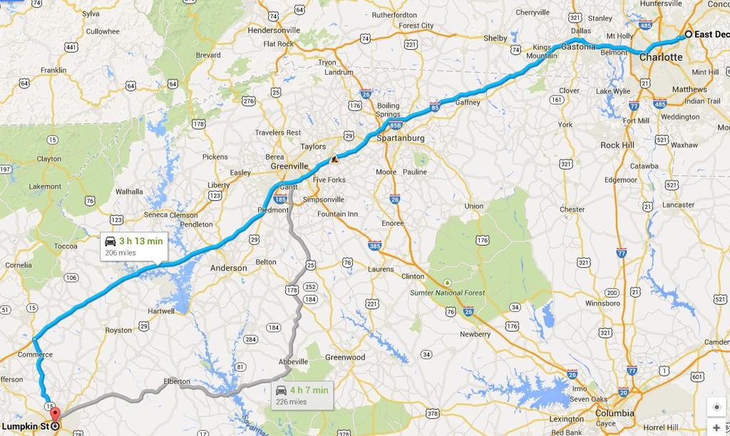
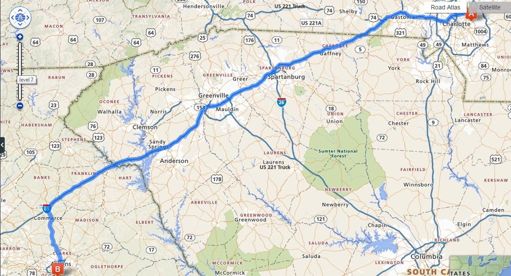
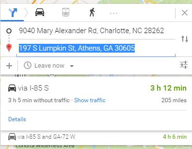
2 GoogleMaps 205 miles Rand McNally 205.4miles


3 Yahoo miles Open Mapquest miles
4 Online geographic data providers 1 Web services such as: Google Maps, Bing Maps, MapQuest Provide unprecedented access to spatial data and analytical tools geocoding addresses identifying points of interest determining travel directions Simple network analysis without the need for a GIS network dataset No data preparation necessary Available to GIS and non-gis users alike
5 Online geographic data providers 1 For sizeable use, generally require a paid license Directions service requests are limited otherwise Google Maps 2,500/day Bing Maps 10,000/90-days MapQuest 5,000/day An alternative is using openly sourced, public domain volunteered geographic information (VGI) MapQuestOpen unlimited
6 Volunteered Geographic Information 1 the widespread engagement of large numbers of private citizens, often with little in the way of formal qualifications, in the creation of geographic information (Goodchild 2007) One of the most successful examples of VGI, OpenStreetMap (OSM), offers a free, editable map of the world with no restrictions governing use for spatial analysis
7 VGI data quality 1 Despite VGI s potential, the question remains: What is the quality of this data? Because participants potentially lack any formal training in geographic data collection, central coordination is weak to non-existent, and adherence to a particular data structure is not required, no assumptions can be made about the overall quality of uploaded data (Goodchild & Li 2012)

 In comparison to the Ordnance Survey of Great Britain,")

8 Literature VGI data quality - Comparative assessments 2 Girres & Touya (2010) In comparison to the French National Mapping Agency, point positional displacement was on average 6.65 meters Haklay (2010) In comparison to the Ordnance Survey of Great Britain, greater than 81% overlap among major roads and an average of 6 meters point displacement of the OSM dataset within study sites across London Ciepłuch et al. (2010) In comparison to Google Maps and Bing Maps, accuracy is inconsistent among all three providers
 (Goodchild & Li 2012) Haklay et al.")
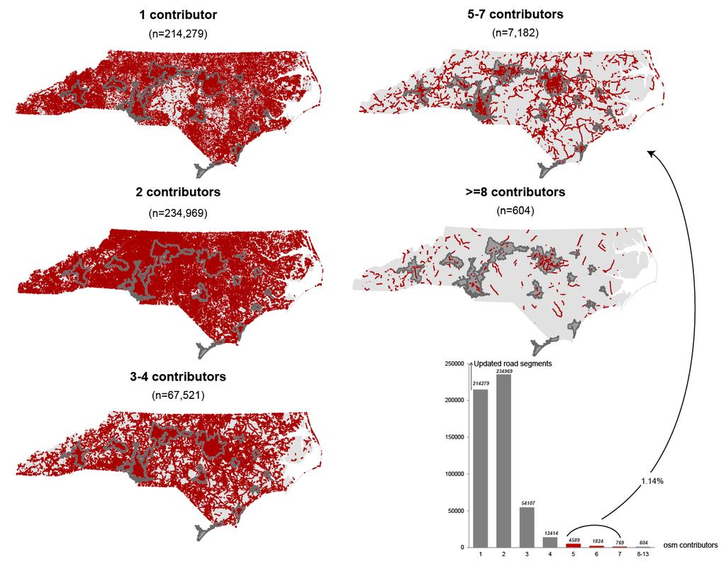
9 VGI data quality - Indicator assessments 2 if one individual contributes an error, others can be expected to edit and correct the error, and the success of this mechanism rises in proportion to the number who look at the contribution (Linus law) (Goodchild & Li 2012) Haklay et al. (2010) Positional accuracy improved with an increase in the number of contributors up to a threshold (n>13) at which improvement stabilized Keßler & Groot (2010) Without a reference dataset, the volume of user contribution to an area or object in OSM is positively correlated to trustworthiness of the dataset
10 Research objectives and 3 questions I. Evaluating the Uncertainty of Travel Impedance Estimates What is the degree of uncertainty in travel impedance estimates among online road network data providers? Do routes calculated using VGI data present significantly different travel impedance estimates in comparison to commercial online spatial datasets? II. VGI User Contribution Applying Linus s Law at the Network Object Level Correlation between number of contributors and level of agreement?
11 Methodology 4 Identify O-D Pairs Travel Estimation: d ij,k, t ij,k Origins Destinations Network Snapping Tertiary Roads O-D Pairs Lat/Long Points Batch Routing Network Provider API Google Maps ArcGIS Online JavaScript Object Notation (JSON) Travel Time & Distance Estimates OpenStreetMap Linus s Law Disagreement Assessment: Distance weighted contributor average Route Contributor Average ݓ ) C a = ݐ ) ݓ * c Store Contributor Information Network Metadata API OpenStreetMap Identify route road segments Network Metadata API MapQuest Open OpenStreetMap 1. Difference (Δd, Δt) among online providers 2. Percent Difference 3. Correlation (r)

12 Case study area 4 North Carolina offers several clear urban locations, a diverse road network, and a range of topographical environments to assess road network uncertainty.

13 Methodology 4 Origins Destinations Identify O-D Pairs Network Snapping Tertiary Roads O-D Pairs Lat/Long Points Remove limited access roads from network dataset. Origins and destinations selected from tertiary roads Modified dataset segmented at nodes; begin nodes serve as candidate origin and destination points Specific implementation study area dependent; discussed further in results Select n*2 number of randomly distributed of candidate points used to form n number of origindestination (OD) pairs Store OD pairs in text file as latitude, longitude and unique identifier
14 Example of North Carolina - (total = 100,000 OD pairs): 14,300 pairs are selected in each of seven distance intervals: 0-50 kilometers (km), km, km, km, km, km and km. It was necessary to increase the range of the category intervals for the longer distances to accomplish an equally stratified sample. Results OD selection 6 Road network, State of North Carolina Exclude interstate highways Identify begin and nodes of all resulting road segments Exclude begin nodes in the proximity of highways (incorrect snapping) (*) 300 pairs of vertices were selected at random for each county (stratified random sampling of vertices) P =306,788 Q =47,059,285,078 P =30,000 P c = 300(*) Q =449,985,000

15 Results OD selection 6 Ex) North Carolina All pairs of OD points Spider map of OD pairs originating or terminating in Ashe County
16 Methodology Online data providers (k): Reference Datasets: Google Maps (TeleAtlas) ArcGIS Online (NavTeq) VGI Dataset: OpenStreetMap Technical Issues: Google Directions API limited to 2,500 requests per day ArcGIS Online requires license OpenStreetMap directions algorithm provided by MapQuest Open Assuming no significant difference due to heuristic or routing algorithm Travel estimations do not account for traffic or other realtime data Precision limited to 1/10 th mile Batch Routing Network Provider API Google Maps ArcGIS Online OpenStreetMap JavaScript Object Notation (JSON) 4 Travel Estimation: d ij,k, t ij,k In Python: For each OD pair, a URL string is formed that includes the network provider web address, OD coordinates, and routing specifications. A new URL is created for each provider, k. Results returned in JavaScript Object Notation (JSON), an easily read data format that uses key-value pairs. Travel Time & Distance Estimates

17 Methodology Travel Impedance Estimates d ij : travel distance t ij : travel time Batch Routing Network Provider API Google Maps ArcGIS Online OpenStreetMap JavaScript Object Notation (JSON) 4 Travel Estimation: d ij,k, t ij,k Travel Time & Distance Estimates ODIndex originlat originlng destinationlat destinationlng GoogleMile GoogleMin ArcGISMile ArcGISMin OSMMile OSMMin
18 Results 6 Low uncertainty in estimated travel distance ArcGIS Online overestimates

19 Results 6 Correlation Coefficients NC Outlier(s) Google Maps includes ferries in the routing calculation
20 Results 6
21 What about contributors?
22 Methodology 4 = Segment distance ݓ (selected) = Total ݓ = ݐ segment distance c ݓ = Number of segment contributors Distance weighted contributor average Route Contributor Average ݓ ) C a = ݐ ݓ ) C a = ݐ ) ݓ * c * c ݓ ) Fewer contributors are required to validate shorter road segments, Linus s Law Store Contributor Information Network Metadata API OpenStreetMap Identify route road segments Network Metadata API MapQuest Open OpenStreetMap but a higher proportion of contributors is needed to verify the accuracy of a longer route A sample of road segments is used from the total route; thus, the user average is proportional to the length of known road segments
23
24 Results Linus s Law 6 North Carolina OD pairs Level of uncertainty decreases as number of contributors increases Initial increase in uncertainty corresponds to greatest sample of contributor averages (overall average = 3.27) Large number of outliers
25 Results at different distances mi 25-75mi mi >250mi
26 Discussion and conclusion 7 Correlation coefficients and percent difference both resulted in relatively high agreement. 1. Uncertainty was extremely low at long travel distances 2. Shorter, county wide distances showed greater uncertainty among all providers 3. The VGI dataset OSM was as reliable as the two commercial providers in estimating travel distance 4. OpenStreetMap may be a viable dataset for routing and navigation purposes within the selected study areas
27 Discussion and conclusion 7 VGI User Contribution Applying Linus s Law at the Network Object Level 1. Disagreement decreases with increasing number of contributors 2. Relationship not uniform across different route lengths.
28 Future research opportunities 7 Approach could be expanded to new areas of the OSM dataset (e.g. other regions and countries) Urban travel Rural travel Analyze overlap among individual routes to explain where and why travel impedance uncertainty occurred Is the trend of the Linus s Law valid in other states and other countries?
29 Thank you Derek Marsh Eric Delmelle Coline Dony Department of Geography and Earth Sciences University of North Carolina at Charlotte


30 Results Correlation Coefficients Mecklenburg County 6 Greater uncertainty across all providers Correlation still high Same pattern of under/overestimation Greater uncertainty at miles
31 Results Percent Difference Mecklenburg County 6 Trend in correlation plots are corroborated by percent difference ArcGIS Online produces greater uncertainty around 15 miles OSM has greater uncertainty at 30 miles
VGI and formal data. EEO / AGI (Scotland) seminar. David Fairbairn Newcastle University School of Civil Engineering & Geosciences
 seminar. David Fairbairn Newcastle University School of Civil Engineering & Geosciences") VGI and formal data EEO / AGI (Scotland) seminar David Fairbairn Newcastle University School of Civil Engineering & Geosciences VGI and formal data Investigating the possible interaction between informal
VGI and formal data EEO / AGI (Scotland) seminar David Fairbairn Newcastle University School of Civil Engineering & Geosciences VGI and formal data Investigating the possible interaction between informal
Collecting a Ground Truth Dataset for OpenStreetMap
 Collecting a Ground Truth Dataset for OpenStreetMap Carsten Keßler Institute for Geoinformatics, University of Münster soon: Hunter College, CUNY http://carsten.io @carstenkessler Background Study: Can
ASSESSING THE QUALITY OF OPEN SPATIAL DATA FOR MOBILE LOCATION-BASED SERVICES RESEARCH AND APPLICATIONS
 Archives of Photogrammetry, Cartography and Remote Sensing, Vol. 22, 2011, pp. 105-116 ISSN 2083-2214 ASSESSING THE QUALITY OF OPEN SPATIAL DATA FOR MOBILE LOCATION-BASED SERVICES RESEARCH AND APPLICATIONS
Exploratory Completeness Analysis of Mapillary for Selected Cities in Germany and Austria
 535 Exploratory Completeness Analysis of Mapillary for Selected Cities in Germany and Austria Levente Juhasz and Hartwig Hochmair University of Florida, Fort Lauderdale/USA levente.juhasz@ufl.edu Full
Assessing OSM Road Positional Quality With Authoritative Data
 Assessing OSM Road Positional Quality With Authoritative Data Francisco ANTUNES 1, Cidália C. FONTE 1, Maria Antonia BROVELLI 2, Marco MINGHINI 2, Monia MOLINARI 2 and Peter MOONEY 3 1 Universidade de
INTRODUCTION. 13 th AGILE International Conference on Geographic Information Science 2010 Page 1 of 15 Guimarães, Portugal
 13 th AGILE International Conference on Geographic Information Science 2010 Page 1 of 15 A Comparative Study of Proprietary Geodata and Volunteered Geographic Information for Germany Dennis Zielstra 1,
Automated Assessment and Improvement of OpenStreetMap Data
 Automated Assessment and Improvement of OpenStreetMap Data Musfira Jilani 1, Padraig Corcoran 1, Michela Bertolotto 1 1 School of Computer Science and Informatics, University College Dublin, Ireland Tel.
An open source approach for the intrinsic assessment of the temporal accuracy, up-todateness and lineage of OpenStreetMap
 An open source approach for the intrinsic assessment of the temporal accuracy, up-todateness and lineage of OpenStreetMap Marco Minghini 1,2, Maria Antonia Brovelli 2, Francesco Frassinelli 2 1 European
Getting Started with Community Maps
 Esri International User Conference San Diego, California Technical Workshops July 24, 2012 Getting Started with Community Maps Shane Matthews and Tamara Yoder Topics for this Session ArcGIS is a complete
Sensitivity of estimates of travel distance and travel time to street network data quality
 Sensitivity of estimates of travel distance and travel time to street network data quality Paul Zandbergen Department of Geography University of New Mexico Outline Street network quality Approaches to
Application of WebGIS and VGI for Community Based Resources Inventory. Jihn-Fa Jan Department of Land Economics National Chengchi University
 Application of WebGIS and VGI for Community Based Resources Inventory Jihn-Fa Jan Department of Land Economics National Chengchi University OUTLINE Introduction Methodology Results Conclusions 2 MOTIVATION
Road Network Impedance Factor Modelling Based on Slope and Curvature of the Road
 Cloud Publications International Journal of Advanced Remote Sensing and GIS 2017, Volume 6, Issue 1, pp. 2274-2280 ISSN 2320 0243, Crossref: 10.23953/cloud.ijarsg.289 Methodology Article Road Network Impedance
Development of a server to manage a customised local version of OpenStreetMap in Ireland
 Development of a server to manage a customised local version of OpenStreetMap in Ireland BłaŜej Ciepłuch 1, Jianghua Zheng 1, Peter Mooney 1,2, Adam C. Winstanley 1 1 Department of Computer Science, National
Internet GIS Sites. 2 OakMapper webgis Application
 Internet GIS Sites # Name URL Description 1 City of Sugar Land http://www.sugarlandtx.gov/index.htm It is a city in Texas with 65,000 Residents. The City of Sugar Land, Texas, provides ArcIMS-based maps
Is OSM Good Enough for Vehicle Routing? A Study Comparing Street Networks in Vienna
 Is OSM Good Enough for Vehicle Routing? A Study Comparing Street Networks in Vienna Anita Graser, Markus Straub, Melitta Dragaschnig Dynamic Transportation Systems, Mobility Department, AIT Austrian Institute
Quality Evaluations on Canadian OpenStreetMap Data
 Quality Evaluations on Canadian OpenStreetMap Data Matthew Tenney 1 1 McGill University, Montreal, QC, Matthew.Tenney@mail.mcgill.ca Abstract The OpenStreetMap (OSM) project represents one of the more
V1.0. Session: Labelled Maps Verification, entering names into a GIS and Google Maps/Earth. Pier-Giorgio Zaccheddu
 Session: Labelled Maps Verification, entering names into a GIS and Google Maps/Earth V1.0 Pier-Giorgio Zaccheddu Federal Agency for Cartography and Geodesy (BKG) Richard-Strauss-Allee 11 60598 Frankfurt
Quality Assessment of Volunteered Geographic Information: An Investigation into the Ottawa-Gatineau OpenStreetMap Database
 Quality Assessment of Volunteered Geographic Information: An Investigation into the Ottawa-Gatineau OpenStreetMap Database by Kent Thomas Jacobs A thesis submitted to the Faculty of Graduate and Postdoctoral
BROOKINGS May
 Appendix 1. Technical Methodology This study combines detailed data on transit systems, demographics, and employment to determine the accessibility of jobs via transit within and across the country s 100
Basic Map Skills for the Outdoors
 Geography 80-20 80% of what there is to know, for 20% of the sweat Basic Map Skills for the Outdoors Map Scale Map source: US Geological Survey Four ways to indicate map scale: Representative fraction
Provision of Web-Based Childcare Support Maps by Local Governments in Japan
 Provision of Web-Based Childcare Support Maps by Local Governments in Japan Mikoto Kukimoto*, Yoshiki Wakabayashi** * Nara Women s University ** Tokyo Metropolitan University Abstract. The aim of this
Road & Railway Network Density Dataset at 1 km over the Belt and Road and Surround Region
 Journal of Global Change Data & Discovery. 2017, 1(4): 402-407 DOI:10.3974/geodp.2017.04.03 www.geodoi.ac.cn 2017 GCdataPR Global Change Research Data Publishing & Repository Road & Railway Network Density
GIS ANALYSIS METHODOLOGY
 GIS ANALYSIS METHODOLOGY No longer the exclusive domain of cartographers, computer-assisted drawing technicians, mainframes, and workstations, geographic information system (GIS) mapping has migrated to
Humans as Sensors: Citizen Science Data to Assess Climate Change
 Humans as Sensors: Citizen Science Data to Assess Climate Change Prof. People, Space and Place Research Cluster School of Environmental Sciences Roxby Building The University of Liverpool Liverpool L69
NR402 GIS Applications in Natural Resources
 NR402 GIS Applications in Natural Resources Lesson 1 Introduction to GIS Eva Strand, University of Idaho Map of the Pacific Northwest from http://www.or.blm.gov/gis/ Welcome to NR402 GIS Applications in
DATA 301 Introduction to Data Analytics Geographic Information Systems
 DATA 301 Introduction to Data Analytics Geographic Information Systems Dr. Ramon Lawrence University of British Columbia Okanagan ramon.lawrence@ubc.ca DATA 301: Data Analytics (2) Why learn Geographic
CHAPTER 22 GEOGRAPHIC INFORMATION SYSTEMS
 CHAPTER 22 GEOGRAPHIC INFORMATION SYSTEMS PURPOSE: This chapter establishes the administration and use of to improve the quality and accessibility of Department s spatial information and support graphical
All About Spatial Data. Find it, Manage it, Use it
 All About Spatial Data Find it, Manage it, Use it Workshop Outline Define spatial data Spatial data formats Data Sources Metadata Evaluating Spatial Data Data Management Activities: define spatial data,
Cross-Linkage Between Mapillary Street Level Photos and OSM Edits
 Cross-Linkage Between Mapillary Street Level Photos and OSM Edits Levente Juhász and Hartwig H. Hochmair Abstract Mapillary is a VGI platform which allows users to contribute crowdsourced street level
Base Maps: Creating, Using & Participating
 Base Maps: Creating, Using & Participating Michael Fashoway & Erin Geraghty Montana Base Map Service Center 2010 MAGIP Technical Session October 28, 2010 What is a Base Map? Using a Base Map Creating a
Salisbury University: Eric Flint, John O Brien, & Alex Nohe
 Salisbury University: Eric Flint, John O Brien, & Alex Nohe Open Source (Public) Geographic Information System GNU General Public License Guarantees public s ability to download, modify and share software
file://q:\report1\greenatlasfinalreportindex.html
 Page 1 of 8 Quick Links WATER MANAGEMENT INTERNSHIP USDA HIS GRANT FUNDED FINAL PROJECT REPORT SUBMITTED BY MELISSA QUINTANA 11/07/07-03/24/08 Summary Provided is an assessment of my accomplishments for
Washington Master Address Services: Project Overview Ben Vaught, OCIO David Wright, DOR Craig Erickson, DOH Tom Kimpel, OFM
 Washington Master Address Services: Project Overview Ben Vaught, OCIO David Wright, DOR Craig Erickson, DOH Tom Kimpel, OFM 2014 IPMA Forum May 21, 2014 Saint Martin's University Lacey, WA March 18 th
presents challenges related to utility infrastructure planning. Many of these challenges
 1 Introduction: - a. Purpose According to U.S. Census Bureau the population of stark county was 367,585 in 1990, and in 2000 it was increase to 378,098. Thus County is experiencing a growth that presents
GIS CONCEPTS Part I. GIS ON THE WEB Part II
 Week 2 GIS CONCEPTS Part I GIS ON THE WEB Part II topics of the week part I GIS functions and GIS data Spatial relationships Organizing convention for spatial data Store Information by thematic layers
SCAUG Community Maps Building a Living Atlas of the World
 SCAUG Community Maps Building a Living Atlas of the World Mark Stewart Topics: SCAUG ArcGIS Online Overview Community Maps Overview Community Maps Workflow Update Process Utilizing Your Contribution Community
Development of an automated matching algorithm to assess the quality of the OpenStreetMap road network
 Student thesis series INES nr 317 Development of an automated matching algorithm to assess the quality of the OpenStreetMap road network - A case study in Göteborg, Sweden Julian Will 2014 Department of
These modules are covered with a brief information and practical in ArcGIS Software and open source software also like QGIS, ILWIS.
 Online GIS Training and training modules covered are: 1. ArcGIS, Analysis, Fundamentals and Implementation 2. ArcGIS Web Data Sharing 3. ArcGIS for Desktop 4. ArcGIS for Server These modules are covered
Key Points Sharing fosters participation and collaboration Metadata has a big role in sharing Sharing is not always easy
 Sharing Resources Geoff Mortson esri, Inc. SDI Solutions Team Key Points Sharing fosters participation and collaboration Metadata has a big role in sharing Sharing is not always easy Data Sharing is Good
GIScience: Current Technology. Michael F. Goodchild University of California Santa Barbara
 GIScience: Current Technology Michael F. Goodchild University of California Santa Barbara What is a GIS? A class of software designed to handle geographic information and perform virtually any conceivable
Understanding Community Mapping as a Socio-Technical Work Domain
 Understanding Community Mapping as a Socio-Technical Work Domain Mark Iliffe 1, Robert J. Houghton 2 and Jeremy Morley 3 1 Horizon Doctoral Training Centre, The University of Nottingham Tel. (0115) 8232316
What is 511? Need for 511 Services. Development & Deployment of Regional Road and Weather Information Supporting 511 Traveler Services
 Development & Deployment of Regional Road and Weather Information Supporting 511 Traveler Services Leon F. Osborne University of North Dakota Regional Weather Information Center Grand Forks, ND David L.
Welcome! Power BI User Group (PUG) Copenhagen
 Copenhagen") Welcome! Power BI User Group (PUG) Copenhagen Making Maps in Power BI Andrea Martorana Tusa BI Specialist Welcome to Making maps in Power BI Who am I? First name: Andrea. Last name: Martorana Tusa. Italian,
Welcome! Power BI User Group (PUG) Copenhagen Making Maps in Power BI Andrea Martorana Tusa BI Specialist Welcome to Making maps in Power BI Who am I? First name: Andrea. Last name: Martorana Tusa. Italian,
Finding Common Ground Through GIS
 Finding Common Ground Through GIS Matthew Stone, MPH Special Unit for Technical Assistance Chronic Disease and Injury Control California Department of Public Health ESRI Health GIS Conference Scottsdale,
Texas A&M University
 Texas A&M University CVEN 658 Civil Engineering Applications of GIS Hotspot Analysis of Highway Accident Spatial Pattern Based on Network Spatial Weights Instructor: Dr. Francisco Olivera Author: Zachry
Multi agent Evacuation Simulation Data Model for Disaster Management Context
 Multi agent Evacuation Simulation Data Model for Disaster Management Context Mohamed Bakillah, Alexander Zipf, J. Andrés Domínguez, Steve H. L. Liang GI4DM 2012 1 Content Context Requirements for Enhanced
GeoSUR SRTM 30-m / TPS
 GeoSUR SRTM 30-m / TPS Wm Matthew Cushing (USGS) 16 May 2013 U.S. Department of the Interior U.S. Geological Survey SRTM Mission Shuttle Radar Topography Mission (SRTM) Space Shuttle Endeavour during the
ArcGIS for Applied Economists Session 2
 ArcGIS for Applied Economists Session 2 Mark Westcott LMU Munich June 15, 2015 1 / 31 Topics for this session: Geographic Coordinate Systems Projections Projected Coordinate Systems Geocoding 2 / 31 Some
Subwatersheds File Geodatabase Feature Class
 Subwatersheds File Geodatabase Feature Class Tags subwatersheds, watersheds Summary shows the subwatersheds of the 9 watersheds in TRCA's jurisdiction Description sub watershed boundaries in TRCA jurisdiction.
What are we like? Population characteristics from UK censuses. Justin Hayes & Richard Wiseman UK Data Service Census Support
 What are we like? Population characteristics from UK censuses Justin Hayes & Richard Wiseman UK Data Service Census Support Who are we? Richard Wiseman UK Data Service / Jisc Justin Hayes UK Data Service
Working with ArcGIS Online
 Esri International User Conference San Diego, CA Technical Workshops July 12, 2011 Working with ArcGIS Online Bern Szukalski, Deane Kensok Topics for this Session ArcGIS Online Overview ArcGIS Online Content
International Journal of Computer Sciences and Engineering Open Access. Design and Development of tool for assessing OpenStreetMap Completeness
 International Journal of Computer Sciences and Engineering Open Access Research Paper Volume-5, Issue-8 E-ISSN: 2347-2693 Design and Development of tool for assessing OpenStreetMap Completeness Sonali
Transit Time Shed Analyzing Accessibility to Employment and Services
 Transit Time Shed Analyzing Accessibility to Employment and Services presented by Ammar Naji, Liz Thompson and Abdulnaser Arafat Shimberg Center for Housing Studies at the University of Florida www.shimberg.ufl.edu
ASSESSMENT OF THE HOMOGENEITY OF VOLUNTEERED GEOGRAPHIC INFORMATION IN SOUTH AFRICA L. Siebritz a, G. Sithole b, S. Zlatanova c
 ASSESSMENT OF THE HOMOGENEITY OF VOLUNTEERED GEOGRAPHIC INFORMATION IN SOUTH AFRICA L. Siebritz a, G. Sithole b, S. Zlatanova c a Chief Directorate: National Geospatial Information, van der Sterr Building,
SPANISH GOOD (AND NO SO GOOD) PRACTICES IMPLEMENTING INSPIRE
 PRACTICES IMPLEMENTING INSPIRE") SPANISH GOOD (AND NO SO GOOD) PRACTICES IMPLEMENTING INSPIRE HELLO! I am Emilio López I am here because I am the Director of the National Centre for Geographic Information You can find me at elromero@fomento.es
SPANISH GOOD (AND NO SO GOOD) PRACTICES IMPLEMENTING INSPIRE HELLO! I am Emilio López I am here because I am the Director of the National Centre for Geographic Information You can find me at elromero@fomento.es
You are Building Your Organization s Geographic Knowledge
 You are Building Your Organization s Geographic Knowledge And Increasingly Making it Available Sharing Data Publishing Maps and Geo-Apps Developing Collaborative Approaches Citizens Knowledge Workers Analysts
Google Maps and Beyond
 Google Maps and Beyond Aaron Paul First American Title apaul@firstam.com 2015 APRA Symposium Association of Professional Reserve Analysts May 2 nd, 2015 Google Maps and Beyond - Overview Business case
Marine Transportation and Ocean Use
 Marine Transportation and Ocean Use Data Needs for Multi-Disciplinary Long-Term Planning 4 th Biennial TRB-CMTS Research and Development Conference Matt Campo Rutgers University 6/22/2016 Overview What
Among various open-source GIS programs, QGIS can be the best suitable option which can be used across partners for reasons outlined below.
 Comparison of Geographic Information Systems (GIS) software As of January 2018, WHO has reached an agreement with ESRI (an international supplier of GIS software) for an unlimited use of ArcGIS Desktop
ArcGIS Online Routing and Network Analysis. Deelesh Mandloi Matt Crowder
 ArcGIS Online Routing and Network Analysis Deelesh Mandloi Matt Crowder Introductions Who are we? - Members of the Network Analyst development team Who are you? - Network Analyst users? - ArcGIS Online
INSTITUTE OF POLICY AND PLANNING SCIENCES. Discussion Paper Series
 INSTITUTE OF POLICY AND PLANNING SCIENCES Discussion Paper Series No. 1102 Modeling with GIS: OD Commuting Times by Car and Public Transit in Tokyo by Mizuki Kawabata, Akiko Takahashi December, 2004 UNIVERSITY
Zielstra and Hochmair page 1 of 17
 Zielstra and Hochmair page 1 of 17 A Comparative Study of Pedestrian Accessibility to Transit Stations Using Free and Proprietary Network Data Revised version submitted: November 15, 2010 Word Count: 4857
Geographical Bias on Social Media and Geo-Local Contents System with Mobile Devices
 212 45th Hawaii International Conference on System Sciences Geographical Bias on Social Media and Geo-Local Contents System with Mobile Devices Kazunari Ishida Hiroshima Institute of Technology k.ishida.p7@it-hiroshima.ac.jp
GED 554 IT & GIS. Lecture 6 Exercise 5. May 10, 2013
 GED 554 IT & GIS Lecture 6 Exercise 5 May 10, 2013 Free GIS data sources ******************* Mapping numerical data & Symbolization ******************* Exercise: Making maps for presentation GIS DATA SOFTWARE
Assessment of Logical Consistency in OpenStreetMap Based on the Spatial Similarity Concept
 Assessment of Logical Consistency in OpenStreetMap Based on the Spatial Similarity Concept Peyman Hashemi and Rahim Ali Abbaspour Abstract The growth in the number of users and the volume of information
The One and Many Maps: Participatory and Temporal Diversities in OpenStreetMap
 The One and Many Maps: Participatory and Temporal Diversities in OpenStreetMap Tyng Ruey Chuang Institute of Information Science Academia Sinica Taipei, Taiwan Dong Po Deng Institute of Information Science
Census Transportation Planning Products (CTPP)
") Census Transportation Planning Products (CTPP) Penelope Weinberger CTPP Program Manager - AASHTO September 15, 2010 1 What is the CTPP Program Today? The CTPP is an umbrella program of data products, custom
Census Transportation Planning Products (CTPP) Penelope Weinberger CTPP Program Manager - AASHTO September 15, 2010 1 What is the CTPP Program Today? The CTPP is an umbrella program of data products, custom
Application of GIS in Public Transportation Case-study: Almada, Portugal
 Case-study: Almada, Portugal Doutor Jorge Ferreira 1 FSCH/UNL Av Berna 26 C 1069-061 Lisboa, Portugal +351 21 7908300 jr.ferreira@fcsh.unl.pt 2 FSCH/UNL Dra. FCSH/UNL +351 914693843, leite.ines@gmail.com
DataShine Automated Thematic Mapping of 2011 Census Quick Statistics
 DataShine Automated Thematic Mapping of 2011 Census Quick Statistics Oliver O Brien, James Cheshire Department of Geography University College London UKDS Census Applications Conference, July 2015 Contents
The World Bank and the Open Geospatial Web. Chris Holmes
 The World Bank and the Open Geospatial Web Chris Holmes Geospatial is Everywhere QuickTime and a TIFF (Uncompressed) decompressor are needed to see this picture. Spatial Data Infrastructure (SDI) the sources,
The Platform Generation. Derek Law and Ebony Wicks
 The Platform Generation Derek Law and Ebony Wicks GIS Provides the Framework and Process For Applying Geography Analysis and Interpretation Design and Planning Creating Understanding Modeling and Predicting
Integrating Origin and Destination (OD) Study into GIS in Support of LIRR Services and Network Improvements
 Study into GIS in Support of LIRR Services and Network Improvements") Integrating Origin and Destination (OD) Study into GIS in Support of LIRR Services and Network Improvements GIS In Transit Conference, Washington, DC Long Island Rail Road Pyung ho Kim Date: September
Integrating Origin and Destination (OD) Study into GIS in Support of LIRR Services and Network Improvements GIS In Transit Conference, Washington, DC Long Island Rail Road Pyung ho Kim Date: September
CyberGIS: What Still Needs to Be Done? Michael F. Goodchild University of California Santa Barbara
 CyberGIS: What Still Needs to Be Done? Michael F. Goodchild University of California Santa Barbara Progress to date Interoperable location referencing coordinate transformations geocoding addresses point-of-interest
ArcGIS API for Python for Data Scientists. Andrew Chapkowski Alberto Nieto
 ArcGIS API for Python for Data Scientists Andrew Chapkowski Alberto Nieto Analysts, Data Scientists and Developers Source: PyCon India 2018 Python And Data: Past, Present And Future By Peter Wang Why
Mobile GIS Application for Khartoum Public Transportation Network
 Mobile GIS Application for Khartoum Public Transportation Network Mohammed Mahmoud Ibrahim (1) -Department of GIS and Remote Sensing, Faculty of Geoinformatics -Future University of Sudan -Khartoum, Sudan-mohammed.aau@gmail.com
Using GIS to Determine Goodness of Fit for Functional Classification. Eric Foster NWMSU MoDOT
 Using GIS to Determine Goodness of Fit for Functional Classification Eric Foster NWMSU MoDOT Northwest Missouri State Masters of GIScience Degree Program University All Online Coursework Missouri Department
Updating the Urban Boundary and Functional Classification of New Jersey Roadways using 2010 Census data
 Updating the Urban Boundary and Functional Classification of New Jersey Roadways using 2010 Census data By: Glenn Locke, GISP, PMP 1 GIS-T May, 2013 Presentation Overview Purpose of Project Methodology
Tools to Assess Local Health Needs. Richard Leadbeater, Esri NACo 2011 Healthy Counties Forum December 1, 2011
 Tools to Assess Local Health Needs Richard Leadbeater, Esri NACo 2011 Healthy Counties Forum December 1, 2011 Richard Leadbeater currently holds the position of Industry Solutions Manager with Esri. He
Quality analysis of the Parisian OSM toponyms evolution
 CHAPTER 8 Quality analysis of the Parisian OSM toponyms evolution Vyron Antoniou*, Guillaume Touya and Ana-Maria Raimond *Hellenic Military Academy, Greece, v.antoniou@ucl.ac.uk Laboratoire COGIT, Institut
Evaluating e-government : implementing GIS services in Municipality
 Evaluating e-government : implementing GIS services in Municipality Municipality of Thessaloniki - G.I.S. Unit Misirloglou Symeon Head of the GIS Unit ESRI UC - 2016 The GIS Section - subset of the department
Improving Geographical Data Finder Using Tokenize Approach from GIS Map API
 Improving Geographical Data Finder Using Tokenize Approach from GIS Map API Antveer Kaur Department of computer science Banasthali University, Jaipur, Rajasthan, India bntsnghbrr940@gmail.com Shweta Kumari
BROADBAND DEMAND AGGREGATION: PLANNING BROADBAND IN RURAL NORTHERN CALIFORNIA
 BROADBAND DEMAND AGGREGATION: PLANNING BROADBAND IN RURAL NORTHERN CALIFORNIA Steven J. Steinberg, Ph.D a,b, *, Rebecca Degagne a, M.S., Michael Gough a a Institute for Spatial Analysis, Humboldt State
Welcome to NR502 GIS Applications in Natural Resources. You can take this course for 1 or 2 credits. There is also an option for 3 credits.
 Welcome to NR502 GIS Applications in Natural Resources. You can take this course for 1 or 2 credits. There is also an option for 3 credits. The 1st credit consists of a series of readings, demonstration,
INDOT Office of Traffic Safety
 Intro to GIS Spatial Analysis INDOT Office of Traffic Safety Intro to GIS Spatial Analysis INDOT Office of Traffic Safety Kevin Knoke Section 130 Program Manager Highway Engineer II Registered Professional
Smart Citizens. Maria Antonia Brovelli Politecnico di Milano, Italy
 Smart Citizens Maria Antonia Brovelli Politecnico di Milano, Italy UN-GGIM Academic Network Forum Secure Land Rights and Smart Cities: Making It Work for Sustainable Development New York, 31 July 2017
Spatial Data Infrastructure Concepts and Components. Douglas Nebert U.S. Federal Geographic Data Committee Secretariat
 Spatial Data Infrastructure Concepts and Components Douglas Nebert U.S. Federal Geographic Data Committee Secretariat August 2009 What is a Spatial Data Infrastructure (SDI)? The SDI provides a basis for
Dynamic Maps and Historical Context
 Dynamic Maps and Historical Context Jeanette Zerneke International Joint GIS-IDEAS and PNC/ECAI Conference December 2008 Dynamic Maps Roles and Functions of Dynamic Maps in Cultural Collections and Atlases
ISPRS Hanover Workshop, Crowdsourced Mapping: Letting Amateurs into the Temple?
 ISPRS Hanover Workshop, 2013 Crowdsourced Mapping: Letting Amateurs into the Temple? Michael McCullagh Mike Jackson University of Nottingham michael.mccullagh@nottingham.ac.uk mike.jackson@nottingham.ac.uk
LIRR Routes, New York NY, January 2017
 Page 1 of 6 Metadata format: ISO 19139 LIRR Routes, New York NY, January 2017 ISO 19139 metadata content Resource Identification Information Spatial Representation Information Reference System Information
GeoPostcodes. Luxembourg
 Luembourg Luembourg About.com Launched in 2007, website offers comprehensive and reliable databases of localities, streets, administrative regions, ZIP/postal codes and lots of other information for all
Technical Memorandum #2 Future Conditions
 Technical Memorandum #2 Future Conditions To: Dan Farnsworth Transportation Planner Fargo-Moorhead Metro Council of Governments From: Rick Gunderson, PE Josh Hinds PE, PTOE Houston Engineering, Inc. Subject:
Healthsites.io: The Global Healthsites Mapping Project
 Healthsites.io: The Global Healthsites Mapping Project René Saameli 1, Dikolela Kalubi 1, Mark Herringer 2, Tim Sutton 2, Eric de Roodenbeke 3 1 International Committee of the Red-Cross, Lausanne, Switzerland
DATA SOURCES AND INPUT IN GIS. By Prof. A. Balasubramanian Centre for Advanced Studies in Earth Science, University of Mysore, Mysore
 DATA SOURCES AND INPUT IN GIS By Prof. A. Balasubramanian Centre for Advanced Studies in Earth Science, University of Mysore, Mysore 1 1. GIS stands for 'Geographic Information System'. It is a computer-based
How do Free and Open Geodata and Open Standards fit together?
 How do Free and Open Geodata and Open Standards fit together? From Sceptisim versus high Potential to real Applications. Michael Auer, Alexander Zipf University of Bonn, Department of Geography, Chair
Comparative analysis of online mapping sites on a case study of Sofia city center
 Comparative analysis of online mapping sites on a case study of Sofia city center Petar T. Penev Assoc. Prof. Dr. Petar Penev UACEG 1 Smirnenski Blvd. 1046 Sofia, Bulgaria tel. +3592 9634087 fax +3592
Discovery and Access of Geospatial Resources using the Geoportal Extension. Marten Hogeweg Geoportal Extension Product Manager
 Discovery and Access of Geospatial Resources using the Geoportal Extension Marten Hogeweg Geoportal Extension Product Manager DISCOVERY AND ACCESS USING THE GEOPORTAL EXTENSION Geospatial Data Is Very
Tax Jurisdiction Sourcing Data Bases
 Tax Jurisdiction Sourcing Data Bases Reducing Cost and Improving Tax Determination via quality data base information Bob Meador Director, GeoTAX Product Management Group 1 Software Agenda Tax issues Tax
Quality assessment of professional and VGI geo-data in The Netherlands
 Quality assessment of professional and VGI geo-data in The Netherlands Author Supervisor Professor Stefan van den Berg drs. Maarten Zeylmans van Emmichoven prof. drs. Stan Geertman 1 This page is intentionally