Citizens as Sensors: The World of Volunteered Geography. Michael F. Goodchild University of California Santa Barbara
|
|
|
- Collin Walsh
- 5 years ago
- Views:
Transcription
1 Citizens as Sensors: The World of Volunteered Geography Michael F. Goodchild University of California Santa Barbara
2 VGI examples research hissues Case study Outline VGI in emergency management Individual research Discussion
3 The formal naming process U.S. Board on Geographic Names 1890 Ahi hierarchy h of fboards from local lto national no role for amateurs, the general public
4 A distant mirror The Waldseemüller map St Dié-des-Vosges, 1507 a name that t stuck
5 The story so far The modern era authoritative production of geographic information official naming guarantees of accuracy (or inaccuracy) need for economies of scale cost of entry aerial photography, analytic stereoplotters advanced skills printing printing generic products multiple purposes long-lived, emphasizing static phenomena
6 The end of the modern era Growing demandsd geographic information to support Web services wayfinding public decision-making management Legislatures less willing to fund efforts to make the user pay constraints on the US federal government Meltdown in the costs of entry Software replacing the need for skills soft photogrammetry basic cartography anyone can make a map
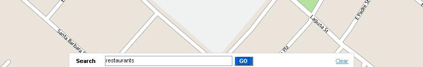
7 popvssoda.com p


8
9
10
11
12
13
14
15
16
17 Neogeography In other words, the old geography involves a prescribed role/interaction between the four main components, namely the audience, the information, the presenter and the subject, which are common to most standard practises of learning. In NeoGeography, there are however no such boundaries on roles, ownership, and interactions of these four components. Rana and Joliveau, Journal of flocation-based Services (in press) The citizen as both consumer and producer of geographic information
18 Volunteered geographic information (VGI) A phenomenon of the 21 st Century recent months User-generated content Collective intelligence Crowdsourcing Asserted information The empowerment of millions of private citizens largely untrained no obvious reward no guarantee of truth th no authority
19 Sensor networks Small, cheap devices smart dust digital it dust Sensing ambient properties uploading to central site


20 Firebugs (UC Berkeley) Motes distributed in advance of a fire compare to problems of overflight GPS or RFID positioning i
21 What makes VGI possible? Web 2.0 from downloaded content to user-generated content compare blogs, wikis Web search engines making it possible to find user-generated content Google Earth mash-ups Jane Austen Google Earth
22 Georeferencing The ability to determine location quickly and easily most people do not know their latitude and longitude what is at N, E? where is St Dié-des-Vosges? Read coordinates from Google Earth etc. GPS
23
24 Concepts Spatial data infrastructure 1993 in U.S. response to declining role of national mapping agency increasing role of local agencies, private sector, individuals A patchwork variable spatial detail determined by local demand, local supply independent contributions integrated with software edge-matched
25 Citizen science Networks of amateur observers possibly trained, skilled Christmas Bird Count thousands of volunteer participants protocols Project GLOBE an international network of school children reporting environmental conditions central integration and redistribution
26 Participant populations Open to all Wikimapia, Flickr Trained or skilled volunteers Christmas Bird Count School children GLOBE Vehicle fleets Inrix Farmers precision agriculture Reversing the traditional top-down flow
27 Coverage A small number of expert mappers located in DC to cover all of the US Mechanized alternatives a small number of automated mapping vehicles a small number of satellites 350 million citizens located nationwide to cover local areas Result is richer and more timely data 27
28 Social issues Locational privacy public persona traded for convenience, security travel patterns can often distinguish between genuine use and criminal use calling emergency services private persona never shared
29
30 They are always watching you. Use cash. Do not give your phone number, social security number or address. Do not fill in questionnaires. Demand that credit firms remove you from marketing lists. Check your medical records often. Keep your telephone number unlisted. Never leave your mobile phone on. Do not use credit or discount cards. If you must use the Internet, use someone else's computer. Assume that all calls, voice mail, and computer use are monitored. The Economist, 1 May 1999


31


32 A spate of burglaries in a Buckinghamshire village had already put residents on the alert for any suspicious vehicles. So when the Google Street View car trundled d towards Broughton with a 360-degree camera on its roof, villagers sprang into action. Forming a human chain to stop it, they harangued the driver about the invasion of privacy, adding that the images that Google planned to put online could be used by burglars. e ece


33
34 Data quality Traditional mapping guarantees bounds on inaccuracy quality can be surprisingly poor legacy data OSM studies show VGI compares well Geographic context Crowdsourcing metrics The VGI site life-cycle
35 earth.google.com
36 nationalmap.gov
37 Authority and assertion Authority inaccuracies are guaranteed formal testing programs metadata Assertion inaccuracies are undocumented no metadata data about popular places tend to be more accurate inaccuracies often less than legacy authoritative data
38
39 Emphasis on the easy stuff Placenames, streets, pictures georeferencing well-defined d reference systems and objects Free production by citizens replacing authoritative production Do other types of geographic information require experts? a catalog of types
40 The FGDC framework layers Transportation basic network rapid updates citizens as probes real-time congestion air quality Hydrography water quality Elevation adequate authoritative sources Orthoimagery cost of entry Cadastral legal issues Administrative units legal issues Geodetic control expertise in geodesy
41 Thematic layers Weather and climate tradition of amateur observers GLOBE Biota Christmas Bird Count e-flora phenology Soils Natural Resource Conservation Service mapping for agricultural advice
42 The soil map An area-class map irregular areas denoting uniform soil type lengthy descriptions of types made by highly trained experts sample points interpolation from ground observation and aerial photography every point assigned to a single class expressed in a unique mapping c = f(x) What is the nature of the expertise?


43 Analysis of sample soils Application/use case Aerial photography Application/use case Historical records of crop performance Application/use case Expert knowledge Application/use case Covariates, e.g. elevation, climate, parent material Application/use case Scale and accuracy issues Application/use case Application knowledge
44 Summary Advanced expertise was needed to make soil maps The generic soil map was the result of severe economies of scale The costs of entry have fallen almost to zero Geographic information on soils can now be purpose-specificspecific using purpose-specific expertise the farmer the gardener
45 Forms of expertise Measurement GPS precision i agriculture Cartography distributed software Subject matter application-specific application-generic Local area
46
47 VGI sources Specialist meeting in Santa Barbara Dec NCGIA Los Alamos National Lab The Vespucci Initiative Army Research Office p g GeoJournal Special Issue edited by Sarah Elwood 72 (3-4):
48 Research program Goodchild, Elwood, Sui Three topics content and quality (UCSB) analysis and synthesis (TAMU) social production (UW) Case studies emergency management (UCSB) community development (UW)
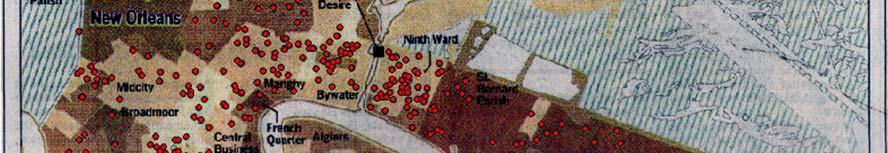
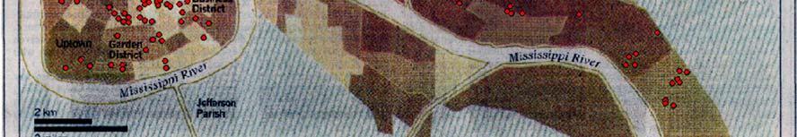
49 Content What are the thematic limits? filling the social-data gap the role of structure in responses what about dynamic phenomena? ethics Preservation who will update? who will preserve? What are the geographic limits? where do the contributors live? what places do they contribute about? itish-students-fined-for-illegal-map-making-in-china.html t d /bl /2009/j /15/d l countries-mapped-good-detail-open-street-map
50 Quality What are suitable metrics? methods for determining quality? The role of metadata t Wiki-style reviews? Metadata 2.0 Who will organize? institutional structures
51 Who s doing it? Long-tail distributions Pareto scaling 3 Wikimapia leaders 140, each IP addresses Inference from postings
52 Robinson projection Articles with geotags # of articles per unit area (log scale, 0.1 resolution) 988,522 articles 103,291 distinct locations
53 Wikipedia authorship Registered authors Only username required Name, , etc. optional IP address kept hidden Anonymous authors IP address made public But nothing else Contributions to Copenhagen Opera House # of Contributions Username or IP Most Recent 18 Dybdahl 18-Sep (anon) 12-Jan Viva-Verdi 8-Sep Hemmingsen 3-Jan (anon) 15-Apr Thue 28-Feb Ghent 30-Apr Valentinian 7-Jan (anon) 10-Apr (anon) 29-Sep (anon) 15-Oct Uppland 24-Dec (anon) 12-Jan-2006
54 University of California, Santa Barbara 135 anonymous authors with 719 revisions; signature distance = 533 km
55 64% of articles at 2,000 km or less???
56

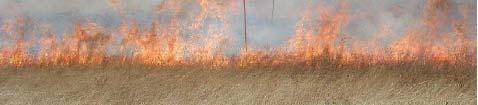
 in New Orleans,")


57 Cyberscape: Placemarks in post-katrina New Orleans Flooding Reports (via Scipionus) in New Orleans, Sept Who was able to or interested in using this new technology? Which places were they interested in? Crutcher and Zook GeoForum
58 Jesus and Allah BLUE = (more Jesus than Allah); RED = (more Allah than Jesus). Size of the bubble show the magnitude of the difference
59
60 What are they doing it about? <x,z,z(x)> Framework data common themes that support wayfinding, georeferencing Federal Geographic Data Committee geodetic control property ownership administrative boundaries Earth imagery topography p hydrography transportation
61 Crandall et al Mapping the world s photos.
62 Tracks inferred from Flickr postings ( cornell edu/~crandall/papers/mapping09www pdf)
63 Summary points A post-modern solution to geographic information production Engaging the citizen as both consumer and producer Raising fundamental issues about the nature of geographic expertise Revolutionizing the practice of geography
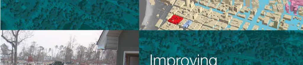
64 Emergency management Recent fires in Santa Barbara Zaca Fire (July 07) burned for 2 months no houses lost Gap Fire (July 08) burned for 7 days no houses lost Tea Fire (November 08) burned for 2 days 230 houses lost
65


66 NYC Office of Emergency Management and NY Office of Cyber Security and Critical Infrastructure t Coordination


67 Andrew Curtis, Department of Geography, Louisiana State University nuim ie/ncg/events/ /
68
69


70 For free PDF version of final report, Google Successful Response Mapping Science Committee


71 Geospatial information is central in all aspects of emergency management Mitigation for future events Planning for future events Response and recovery Image credits: left, courtesy NGA; top, right courtesy FEMA; bottom right, courtesy John Palatiello, MAPPS/NYS Office of Cyber Security & Critical Infrastructure Coordination/EarthData International


72 Maps are essential in the earliest stages of search and rescue Overhead images provide the best early source of information on damage Importance of evacuation planning Image credits: top, courtesy Schad Meldrum, City of Oklahoma City; middle, courtesy NOAA; bottom, courtesy Richard Church, University of California, Santa Barbara


73 Geospatial data and tools have the potential to contribute to the saving of lives, the limitation of damage, and reduction in the costs to society of dealing with emergencies
74
75
76
77 Hits Source Jesusita Fire (Ethan) SBC Jesusita Fire Santa Barbara, CA (Robert O'Connor - fire news blog) Jesusita Fire Map (Randy - Independent.com) Jesusita Fire in Santa Barbara - LA Times map (Los Angeles Times) Map of burned homes in Santa Barbara (Los Angeles Times) Jesusita Fire Evacuation Areas: Approximation (COSB) Santa Barbara 'Jesusita Fire' (ABC7 Eyewitness News) Jesusita Fire - Santa Barbara (lanewspace) 2446 Santa Barbara Damaged Homes 2008 (Los Angeles Times, note: mapped for comparison with Jesusita) 2048 Jesusita Fire (longhairedhippy) 1314 Santa Barbara Fire Evacuation (Gary); 962 Jesusita Fire in Santa Barbara (ABC30 Action News) 788 Wildfire ~ Santa Barbara (Buffalo) 505 Closure map - Jesusita Fire in Santa Barbara (Los Angeles Times) 461 Untitled (Matthew, note: discovered via google.com.mx); 396 Jesusita Fire Structure Damage (Paul Bartsch); 77
78 VGI Important t in all three cases first photographs of Tea Fire appeared on Flickr in minutes maps, text accounts Search engines (Google) take a finite time to catalog too long for Tea Fire Flickr and other site-specific specific catalogs work much faster after Zaca Fire people p knew where to look for rapidly available information
79 Lessons learned Authoritative ti information must be verified by officials too slow for the Tea Fire Asserted information carries risk of false positives false rumor of a fire in Mission i Canyon some unnecessary evacuations people are willing to accept false positives lack of authoritative information amounts to false negatives false negatives are far less acceptable than false positives there were some posted false negatives


80 LA Times May
81 VGI inventories i / t /fi d Questions: who does it? demographics what do they do it about? content applications structured or unstructured? QA/QC protocols where in the life cycle? 81
California Reality and Nova Scotia Dreaming. Michael F. Goodchild University of California Santa Barbara
 California Reality and Nova Scotia Dreaming Michael F. Goodchild University of California Santa Barbara 1 The geospatial world Remote sensing Geographic information systems Automated cartography Global
The Future of Geography in an. Society. Michael F. Goodchild University of California Santa Barbara
 The Future of Geography in an Emerging Information-Technology Society Michael F. Goodchild University of California Santa Barbara Geographic technologies Positioning i on the Earth s surface GPS, RFID
Michael F. Goodchild University of California Santa Barbara
 The Changing Face of GIS Michael F. Goodchild University of California Santa Barbara 1 Two topics New data sources Critical spatial thinking 2 How is geographic information created? By authorities and
Citizens as Sensors: Web 2.0 and the World of Volunteered Geography. Michael F. Goodchild University of California Santa Barbara
 Citizens as Sensors: Web 2.0 and the World of Volunteered Geography Michael F. Goodchild University of California Santa Barbara How is geographic information created? By authorities USGS NGA Ordnance Survey
Michael F. Goodchild University of California Santa Barbara
 The Changing Face of GIS Michael F. Goodchild University of California Santa Barbara 1 Two topics New data sources Critical spatial thinking 2 How is geographic information created? By authorities and
Vision 2020: Focus on the Future. Michael F. Goodchild University of California Santa Barbara
 Vision 2020: Focus on the Future Michael F. Goodchild University of California Santa Barbara A little context Gore, Earth in the Balance, 1992 a single portal to Earth information Fall 1997 Tom Kalil,
Geographic Information Systems and Science: Today and Tomorrow. Michael F. Goodchild University of California Santa Barbara
 Geographic Information Systems and Science: Today and Tomorrow Michael F. Goodchild University of California Santa Barbara Geospatial technologies Positioning on the Earth s surface GPS, RFID Acquisition
The Spatial Web: Visions for a Geospatial World. Michael F. Goodchild Walton Fellow National Centre for Geocomputation
 The Spatial Web: Visions for a Geospatial World Michael F. Goodchild Walton Fellow National Centre for Geocomputation Outline Context Current technology My own research Technological vision Social issues
Spatial Data Infrastructure Concepts and Components. Douglas Nebert U.S. Federal Geographic Data Committee Secretariat
 Spatial Data Infrastructure Concepts and Components Douglas Nebert U.S. Federal Geographic Data Committee Secretariat August 2009 What is a Spatial Data Infrastructure (SDI)? The SDI provides a basis for
GIS = Geographic Information Systems;
 What is GIS GIS = Geographic Information Systems; What Information are we talking about? Information about anything that has a place (e.g. locations of features, address of people) on Earth s surface,
Title: Storm of the Century: Documenting the 1993 Superstorm
 A. PAIIF 2011 Cover Page Title: Storm of the Century: Documenting the 1993 Superstorm Point of Contact: Name: Alex Granger Email: alex.granger@noaa.gov Phone Number: 571-555-9278 Mailing Address: Research
Smart Citizens. Maria Antonia Brovelli Politecnico di Milano, Italy
 Smart Citizens Maria Antonia Brovelli Politecnico di Milano, Italy UN-GGIM Academic Network Forum Secure Land Rights and Smart Cities: Making It Work for Sustainable Development New York, 31 July 2017
US National Spatial Data Infrastructure A Spatial Framework for Governance and Policy Development to Enable a Location-Based Digital Ecosystem
 GeoPlatform Workshop 7 Dec 2016, Department of the Interior Washington, D.C. US National Spatial Infrastructure A Spatial Framework for Governance and Policy Development to Enable a Location-Based Digital
GEOGRAPHIC INFORMATION SYSTEMS Session 8
 GEOGRAPHIC INFORMATION SYSTEMS Session 8 Introduction Geography underpins all activities associated with a census Census geography is essential to plan and manage fieldwork as well as to report results
Towards data driven decision-making using crowd-sourced geographic information. Linna Li University of Redlands December 2, 2015
 Towards data driven decision-making using crowd-sourced geographic information Linna Li (linna.li@csulb.edu) University of Redlands December 2, 2015 WalMap: Walgreens store location map Geographic information
Reimaging GIS: Geographic Information Society. Clint Brown Linda Beale Mark Harrower Esri
 Reimaging GIS: Geographic Information Society Clint Brown Linda Beale Mark Harrower Esri 8 billion = Number of basemap requests per month on AGOL 14,000 = Unique requests per second 12,000 = New Items
GIScience: Current Technology. Michael F. Goodchild University of California Santa Barbara
 GIScience: Current Technology Michael F. Goodchild University of California Santa Barbara What is a GIS? A class of software designed to handle geographic information and perform virtually any conceivable
2018 NASCIO Award Submission Category: Cross-Boundary Collaboration and Partnerships. Project Title: Tennessee Wildfires: A Coordinated GIS Response
 2018 NASCIO Award Submission Category: Cross-Boundary Collaboration and Partnerships Project Title: Tennessee Wildfires: A Coordinated GIS Response Sevier County, Tennessee State of Tennessee, Emergency
GEOMATICS. Shaping our world. A company of
 GEOMATICS Shaping our world A company of OUR EXPERTISE Geomatics Geomatics plays a mayor role in hydropower, land and water resources, urban development, transport & mobility, renewable energy, and infrastructure
Cartographic and Geospatial Futures
 Cartographic and Geospatial Futures 1. Web Cartography, WebGIS, & Virtual Globes--New Roles for Maps, GIS, and GIS professionals 2. Map Mashups, the Neo Neo-geography Movement, & Crowd-sourcing Geospatial
Building a National Data Repository
 Building a National Data Repository Mladen Stojic, Vice President - Geospatial 1/30/2013 2012 Intergraph Corporation 1 Information has meaning and gives power only when shared and distributed. Information,
Citizen Science at the. U.S. Geological Survey
 Citizen Science at the U.S. Geological Survey David Applegate USGS Associate Director for Natural Hazards NRC Board on Earth Science & Resources December 5, 2014 U.S. Department of the Interior U.S. Geological
A.C.R.E and. C3S Data Rescue Capacity Building Workshops. December 4-8, 2017 Auckland, New Zealand. Session 3: Rescue of Large Format and Analog Data
 A.C.R.E and C3S Data Rescue Capacity Building Workshops December 4-8, 2017 Auckland, New Zealand Dr. Rick Crouthamel, D.Sc. Executive Director Session 3: Rescue of Large Format and Analog Data 4 December
United States Multi-Hazard Early Warning System
 United States Multi-Hazard Early Warning System Saving Lives Through Partnership Lynn Maximuk National Weather Service Director, Central Region Kansas City, Missouri America s s Weather Enterprise: Protecting
Citizens as sensors: the world of volunteered geography
 DOI 10.1007/s10708-007-9111-y Citizens as sensors: the world of volunteered geography Michael F. Goodchild Published online: 20 November 2007 Ó Springer Science+Business Media B.V. 2007 Abstract In recent
GIS Visualization: A Library s Pursuit Towards Creative and Innovative Research
 GIS Visualization: A Library s Pursuit Towards Creative and Innovative Research Justin B. Sorensen J. Willard Marriott Library University of Utah justin.sorensen@utah.edu Abstract As emerging technologies
IMPLEMENTING GOVERNMENT-WIDE ENTERPRISE GIS; THE FEDERATED MODEL
 IMPLEMENTING GOVERNMENT-WIDE ENTERPRISE GIS; THE FEDERATED MODEL James E. Mitchell, Ph. D. IT GIS Manager Louisiana Department of Transportation and Development presented at the ESRI International Users
ArcGIS for INSPIRE. Marten Hogeweg
 ArcGIS for INSPIRE Marten Hogeweg Please Take Our Survey on the App Download the Esri Events app and find your event Select the session you attended Scroll down to find the feedback section Complete answers
GIS Capability Maturity Assessment: How is Your Organization Doing?
 GIS Capability Maturity Assessment: How is Your Organization Doing? Presented by: Bill Johnstone Principal Consultant Spatial Vision Group November 8, 2018 1. Motivation for Capability Maturity Models
Experiences and Directions in National Portals"
 FIG Seminar on e-land Administration Innsbruck/Austria 2-4 June 2004 "ESRI's Experiences and Directions in National Portals" Kevin Daugherty Cadastral/Land Records Manager ESRI Topic Points Technology
Esri s Living Atlas of the World Community Maps
 Esri s Living Atlas of the World Community Maps Seth Sarakaitis Wednesday May 7, 2014 ArcGIS Living Atlas Concept Living Atlas Content Tour Contributing to the Living Atlas (Community Maps) Seth Sarakaitis
GIS Building Communities beyond National Borders (Building Successful Spatial Data Infrastructures) Nick Land, ESRI Europe
 Nick Land, ESRI Europe") GIS Building Communities beyond National Borders (Building Successful Spatial Data Infrastructures) Nick Land, ESRI Europe UK worst flooding in the last 60 years 350,000 households without drinking water
GIS Building Communities beyond National Borders (Building Successful Spatial Data Infrastructures) Nick Land, ESRI Europe UK worst flooding in the last 60 years 350,000 households without drinking water
ENVIRONMENT AND NATURAL RESOURCES 3700 Introduction to Spatial Information for Environment and Natural Resources. (2 Credit Hours) Semester Syllabus
 Semester Syllabus") ENVIRONMENT AND NATURAL RESOURCES 3700 Introduction to Spatial Information for Environment and Natural Resources COURSE INSTRUCTOR: Dr. Kris Jaeger Assistant Professor 359 Kottman Hall (Mondays and Tuesdays)
ENVIRONMENT AND NATURAL RESOURCES 3700 Introduction to Spatial Information for Environment and Natural Resources COURSE INSTRUCTOR: Dr. Kris Jaeger Assistant Professor 359 Kottman Hall (Mondays and Tuesdays)
geographic patterns and processes are captured and represented using computer technologies
 Proposed Certificate in Geographic Information Science Department of Geographical and Sustainability Sciences Submitted: November 9, 2016 Geographic information systems (GIS) capture the complex spatial
Welcome Survey getting to know you Collect & log Supplies received Classroom Rules Curriculum overview. 1 : Aug 810. (3 days) 2nd: Aug (5 days)
 2nd: Aug (5 days)") 1st Quarter (41Days) st 1 : Aug 810 (3 days) 2nd: Aug 13-17 Reporting Categories (TEKS SEs) Skill Create and write a postcard about your favorite community activity Review 2nd Grade Vocabulary Chapter
1st Quarter (41Days) st 1 : Aug 810 (3 days) 2nd: Aug 13-17 Reporting Categories (TEKS SEs) Skill Create and write a postcard about your favorite community activity Review 2nd Grade Vocabulary Chapter
A Correlation of. Eastern Hemisphere. Ohio s Learning Standards Social Studies: K-12 Grade 6
 A Correlation of Eastern Hemisphere To Grade 6 to,, Grade 6 Introduction This document demonstrates how, Eastern Hemisphere, Ohio Edition, meets : K-12 Social Studies for Grade 6. Correlation page references
Climate Risk Visualization for Adaptation Planning and Emergency Response
 Climate Risk Visualization for Adaptation Planning and Emergency Response NCR Flood Fact Finding Workshop Ricardo Saavedra ricardo@vizonomy.com Social Media, Mobile, and Big Data St. Peter s Basilica,
Putting the U.S. Geospatial Services Industry On the Map
 Putting the U.S. Geospatial Services Industry On the Map December 2012 Definition of geospatial services and the focus of this economic study Geospatial services Geospatial services industry Allow consumers,
Challenges and Potentials of Place Based Information Management in Nepal"
 Nineteenth United Nations Regional Cartographic Conference for Asia and the Pacific, Bangkok, Thailand, 29 October 1 November 2012 Challenges and Potentials of Place Based Information Management in Nepal"
The Role of the Louisiana Geographic Information Center in the Response to Hurricane Katrina
 The Role of the Louisiana Geographic Information Center in the Response to Hurricane Katrina By: Jared Chapiewsky & Laura Brown For: URPL 969- GIS Applications in Response to Hurricane Katrina Date: March
Crowdsourcing, Citizen Science & INSPIRE
 Crowdsourcing, Citizen Science & INSPIRE Muki Haklay & Claire Ellul Extreme Citizen Science (ExCiteS) research group, UCL @mhaklay / @UCL_ExCiteS Outline Three eras of environmental information: By experts,
Unit 1, Lesson 2. What is geographic inquiry?
 What is geographic inquiry? Unit 1, Lesson 2 Understanding the way in which social scientists investigate problems will help you conduct your own investigations about problems or issues facing your community
Lecture 9: Reference Maps & Aerial Photography
 Lecture 9: Reference Maps & Aerial Photography I. Overview of Reference and Topographic Maps There are two basic types of maps? Reference Maps - General purpose maps & Thematic Maps - maps made for a specific
Who has the data? Results of Maryland s 3-Week Statewide GIS Inventory Challenge. This is your state. This is your inventory.
 Who has the data? Results of Maryland s 3-Week Statewide GIS Inventory Challenge This is your state. This is your inventory. Maryland s Need for GIS Inventory Maryland had no central repository for its
GIS Data Conversion: Strategies, Techniques, and Management
 GIS Data Conversion: Strategies, Techniques, and Management Pat Hohl, Editor SUB G6ttlngen 208 494219 98 A11838 ONWORD P R E S S V Contents SECTION 1: Introduction 1 Introduction and Overview 3 Ensuring
Module 2 Educator s Guide Investigation 2
 Module 2 Educator s Guide Investigation 2 How does remote sensing help us to observe human activities on Earth? Investigation Overview Landscapes that are influenced by human activities are found nearly
Open spatial data infrastructure
 Open spatial data infrastructure a backbone for digital government Thorben Hansen Geomatikkdagene 2018 Stavanger 13.-15. mars Spatial Data Infrastructure definition the technology, policies, standards,
Digitization in a Census
 Topics Connectivity of Geographic Data Sketch Maps Data Organization and Geodatabases Managing a Digitization Project Quality and Control Topology Metadata 1 Topics (continued) Interactive Selection Snapping
Exploring Digital Earth. Michael F. Goodchild University of California Santa Barbara
 Exploring Digital Earth Michael F. Goodchild University of California Santa Barbara Some explaining to do What a curious career Nevill Mott, Cavendish Professor of Physics, University of Cambridge, 1965
Geospatial natural disaster management
 Geospatial natural disaster management disasters happen. are you ready? Natural disasters can strike almost anywhere at any time, with no regard to a municipality s financial resources. These extraordinarily
Disaster Management in Mongolia
 The Third UN-GGIM-AP Plenary Meeting Disaster Management in Mongolia ~Coordination among NGIA & Other Related Organizations and Recommendations~ Bali Indonesia 10 November 2014 Khurelshagai Ayurzana, Director
Advanced Image Analysis in Disaster Response
 Advanced Image Analysis in Disaster Response Creating Geographic Knowledge Thomas Harris ITT The information contained in this document pertains to software products and services that are subject to the
Positioning the Pacific: NOAA s Geospatial Activities. Juliana Blackwell, Director NOAA s National Geodetic Survey March 6, 2012
 Positioning the Pacific: NOAA s Geospatial Activities Juliana Blackwell, Director NOAA s National Geodetic Survey March 6, 2012 A Common Problem of the Early 19 th Century 1807 President Thomas Jefferson
Sustainable and Harmonised Development for Smart Cities The Role of Geospatial Reference Data. Peter Creuzer
 Sustainable and Harmonised Development for Smart Cities The Role of Geospatial Reference Data Peter Creuzer 1. Introduction - Smart Cities and Geodata 2. Geodata in Germany 3. Examples 4. Data and Service
Funding systems used in Mexico to support institutional arrangements: INEGI case
 Funding systems used in Mexico to support institutional arrangements: INEGI case Sistemas de financiamiento usados en México, para soportar arreglos institucionales: Caso INEGI United Nations Committee
The Use of Geographic Information Systems (GIS) by Local Governments. Giving municipal decision-makers the power to make better decisions
 by Local Governments. Giving municipal decision-makers the power to make better decisions") The Use of Geographic Information Systems (GIS) by Local Governments Giving municipal decision-makers the power to make better decisions Case Study: Examples of GIS Usage by Local Governments in North
The Use of Geographic Information Systems (GIS) by Local Governments Giving municipal decision-makers the power to make better decisions Case Study: Examples of GIS Usage by Local Governments in North
Open Data meets Big Data
 Open Data meets Big Data Max Craglia, Sven Schade, Anders Friis European Commission Joint Research Centre www.jrc.ec.europa.eu Serving society Stimulating innovation Supporting legislation JRC is Technical
Spatial Data Availability Energizes Florida s Citizens
 NASCIO 2016 Recognition Awards Nomination Spatial Data Availability Energizes Florida s Citizens State of Florida Agency for State Technology & Department of Environmental Protection Category: ICT Innovations
Economic and Social Council 2 July 2015
 ADVANCE UNEDITED VERSION UNITED NATIONS E/C.20/2015/11/Add.1 Economic and Social Council 2 July 2015 Committee of Experts on Global Geospatial Information Management Fifth session New York, 5-7 August
Norwegian spatial data infrastructure supporting disaster risk management Norwegian Mapping Authority
 Norwegian spatial data infrastructure supporting disaster risk management Norwegian Mapping Authority Arvid Lillethun, Norwegian Mapping Authority Land and Poverty 2018 Conference, World Bank 19.-23. March
A Broad View of Geospatial Technology & Systems
 A Broad View of Geospatial Technology & Systems Pete Large Vice President, Trimble On the shoulders of giants 1 Since their time, our ability to generate geospatial information has grown exponentially
Geospatial SDI Portal for effective Governance of Pune METROPOLIS region
 Geospatial SDI Portal for effective Governance of Pune METROPOLIS region Mr. Praveen Gautam Senior Manager 19 th January 2018 PMRDA Overview Provide a Spatial Framework for the entire region with various
Nomination Form. Clearinghouse. New York State Office for Technology. Address: State Capitol-ESP, PO Box
 NASIRE 2001 RECOGNITION AWARDS Recognizing Outstanding Achievement in the Field of Innovative Use of Technology Nomination Form Title of Nomination: Manager/Job Title: Agency: NYS Geographic Information
Kentucky Collaborates in GeoMAPP Project: The Advantages and Challenges of Archiving in a State with a Centralized GIS
 Kentucky Collaborates in GeoMAPP Project: The Advantages and Challenges of Archiving in a State with a Centralized GIS Geospatial Multistate Archive and Preservation Partnership By Glen McAninch Best Practices
Exploit your geodata to enable smart cities and countries
 Exploit your geodata to enable smart cities and countries Carsten Rönsdorf, Head of Advisory Services Middle East Practice Manager Future Cities, standards and 3D 24 November 2014 Importance of Standards
GIS (GEOGRAPHIC INFORMATION SYSTEMS)
") GIS (GEOGRAPHIC INFORMATION SYSTEMS) 1 1. DEFINITION SYSTEM Any organised assembly of resources and procedures united and regulated by interaction or interdependence to complete a set of specific functions.
GIS (GEOGRAPHIC INFORMATION SYSTEMS) 1 1. DEFINITION SYSTEM Any organised assembly of resources and procedures united and regulated by interaction or interdependence to complete a set of specific functions.
Land Administration and Cadastre
 Geomatics play a major role in hydropower, land and water resources and other infrastructure projects. Lahmeyer International s (LI) worldwide projects require a wide range of approaches to the integration
World Atlas With Latitude And Longitude And Cities
 World Atlas With Latitude And Longitude And Cities Free Download WORLD ATLAS WITH LATITUDE AND LONGITUDE AND CITIES LATITUDE AND LONGITUDE FINDER - WORLD ATLAS Wed, 27 Dec 2017 14:35:00 GMT enter any address,
Indiana University Maps
 Indiana University 9.28.09 Maps Maps Mission Action Cause related cartography at National Geographic Networks and Complex Systems This talk series is open to all Indiana University faculty and students
Brazil Paper for the. Second Preparatory Meeting of the Proposed United Nations Committee of Experts on Global Geographic Information Management
 Brazil Paper for the Second Preparatory Meeting of the Proposed United Nations Committee of Experts on Global Geographic Information Management on Data Integration Introduction The quick development of
Integrating Official Statistics and Geospatial Information NBS Experience
 Integrating Official Statistics and Geospatial Information NBS Experience Presented by Eng. Reda AL Sabbagh Director of IT Dept. Prepared by Eng. Adham Makky GIS Specialist Topics to be covered: Background
Continental Divide National Scenic Trail GIS Program
 CDNST Vision Statement: Provide the most accurate geospatial locational information of the Continental Divide Trail and nearby resources to the public as well as help provide internal management information
An Introduction to Geographic Information System
 An Introduction to Geographic Information System PROF. Dr. Yuji MURAYAMA Khun Kyaw Aung Hein 1 July 21,2010 GIS: A Formal Definition A system for capturing, storing, checking, Integrating, manipulating,
The World Bank and the Open Geospatial Web. Chris Holmes
 The World Bank and the Open Geospatial Web Chris Holmes Geospatial is Everywhere QuickTime and a TIFF (Uncompressed) decompressor are needed to see this picture. Spatial Data Infrastructure (SDI) the sources,
1. Which agency in your state is PRIMARILY responsible for archiving geospatial data and managing archived geo records? (choose one) nmlkj.
 nmlkj.") Survey Intro Kentucky, North Carolina, and Utah are partnering with the Library of Congress as part of the National Digital Information Infrastructure and Preservation Program (NDIIPP) to examine the current
Survey Intro Kentucky, North Carolina, and Utah are partnering with the Library of Congress as part of the National Digital Information Infrastructure and Preservation Program (NDIIPP) to examine the current
Google Maps and Beyond
 Google Maps and Beyond Aaron Paul First American Title apaul@firstam.com 2015 APRA Symposium Association of Professional Reserve Analysts May 2 nd, 2015 Google Maps and Beyond - Overview Business case
Spatial Optimization of CoCoRAHS Network in Tennessee. Joanne Logan Department of Biosystems Engineering and Soil Science University of Tennessee
 Spatial Optimization of CoCoRAHS Network in Tennessee Joanne Logan Department of Biosystems Engineering and Soil Science University of Tennessee Abstract CoCoRaHS (Community Collaborative Rain, Hail and
Minnesota K-12 Academic Standards in Social Studies. Grade 4: Geography of North America
 Minnesota K-12 Academic s in Social Studies Grade 4: Geography of North America 4 Describe how people take 1. Democratic government action to influence a depends on informed and decision on a specific
Systems (GIS) - with a focus on.
 - with a focus on.") Introduction to Geographic Information Systems (GIS) - with a focus on localizing the MDGs Carmelle J. Terborgh, Ph.D. ESRI www.esri.com Flying Blind Jul 24th 2003 The Economist We Live in Two Worlds Natural
Introduction to Geographic Information Systems (GIS) - with a focus on localizing the MDGs Carmelle J. Terborgh, Ph.D. ESRI www.esri.com Flying Blind Jul 24th 2003 The Economist We Live in Two Worlds Natural
Compact guides GISCO. Geographic information system of the Commission
 Compact guides GISCO Geographic information system of the Commission What is GISCO? GISCO, the Geographic Information System of the COmmission, is a permanent service of Eurostat that fulfils the requirements
State of Israel Ministry of Housing and Construction Survey of Israel. The Hydrological project case
 State of Israel Ministry of Housing and Construction Survey of Israel The Hydrological project case Survey of Israel Content Introduction To the Survey of Israel The operation assumptions The main responsibilities
Chapter 10: The Future of GIS Why Speculate? 10.2 Future Data 10.3 Future Hardware 10.4 Future Software 10.5 Some Future Issues and Problems
 Chapter 10: The Future of GIS 10.1 Why Speculate? 10.2 Future Data 10.3 Future Hardware 10.4 Future Software 10.5 Some Future Issues and Problems Theme of the Course GIS's place in understanding geographic
How a Media Organization Tackles the. Challenge Opportunity. Digital Gazetteer Workshop December 8, 2006
 A Case-Study-In-Process: How a Media Organization Tackles the Georeferencing Challenge Opportunity Digital Gazetteer Workshop December 8, 2006 to increase and diffuse geographic knowledge 1888 to 2006:
GIS Monroe Geographic Information System March 14, 2018
 GIS Monroe Geographic Information System March 14, 2018 Goals Maintain Enterprise/County-wide geo-database Increase spatial accuracy of data Build and acquire more data layers Increase use of GIS; as another
Understanding China Census Data with GIS By Shuming Bao and Susan Haynie China Data Center, University of Michigan
 Understanding China Census Data with GIS By Shuming Bao and Susan Haynie China Data Center, University of Michigan The Census data for China provides comprehensive demographic and business information
Esri and GIS Education
 Esri and GIS Education Organizations Esri Users 1,200 National Government Agencies 11,500 States & Regional Agencies 30,800 Cities & Local Governments 32,000 Businesses 8,500 Utilities 12,600 NGOs 11,000
CENSUS MAPPING WITH GIS IN NAMIBIA. BY Mrs. Ottilie Mwazi Central Bureau of Statistics Tel: October 2007
 CENSUS MAPPING WITH GIS IN NAMIBIA BY Mrs. Ottilie Mwazi Central Bureau of Statistics E-mail: omwazi@npc.gov.na Tel: + 264 61 283 4060 October 2007 Content of Presentation HISTORICAL BACKGROUND OF CENSUS
Leveraging Geospatial Technology for Cadastral Surveys
 Matthew Delano, LS Geospatial World Forum January 2017 Leveraging Geospatial Technology for Cadastral Surveys Fit-for-Purpose Simple to start Can improve over time whenever necessary Meet the needs of
Disaster Management & Recovery Framework: The Surveyors Response
 Disaster Management & Recovery Framework: The Surveyors Response Greg Scott Inter-Regional Advisor Global Geospatial Information Management United Nations Statistics Division Department of Economic and
Dust Storms in Arizona: The Challenge to Ensure Motorist Safety Jennifer Toth, P.E. Deputy Director for Transportation
 Dust Storms in Arizona: The Challenge to Ensure Motorist Safety Jennifer Toth, P.E. Deputy Director for Transportation Arizona Department of Transportation AASHTO Extreme Weather Event Symposium May 21,
Working with ArcGIS Online
 Esri International User Conference San Diego, CA Technical Workshops July 12, 2011 Working with ArcGIS Online Bern Szukalski, Deane Kensok Topics for this Session ArcGIS Online Overview ArcGIS Online Content
Prof Chryssy Potsiou, FIG President
 THE VALUE OF GEOSPATIAL DATA AND ROLE OF SURVEYORS IN SUSTAINABLE DEVELOPMENT Prof Chryssy Potsiou, FIG President National Technical University of Athens School of Rural and Surveying Engineering, Greece
Web 2.0, map production & publishing and geospatial information dissemenation
 Web 2.0, map production & publishing and geospatial information dissemenation Professor William Cartwright President, International Cartographic Association William Cartwright 18th UNRCC for Asia and the
Climate Resilience Decision Making Framework in the Caribbean. A case of Spatial Data Management
 Climate Resilience Decision Making Framework in the Caribbean A case of Spatial Data Management Bishwa Pandey Sr. Data Management Specialist The World Bank Background The mission of The World Bank s Latin
XXIII CONGRESS OF ISPRS RESOLUTIONS
 XXIII CONGRESS OF ISPRS RESOLUTIONS General Resolutions Resolution 0: Thanks to the Czech Society commends: To congratulate The Czech Society, its president and the Congress Director Lena Halounová, the
Mitigation planning in Epirus- The case of frost and snowfalls. Thematic seminar Epirus September 2011
 Mitigation planning in Epirus- The case of frost and snowfalls Thematic seminar Epirus September 2011 1 Structure of Mitigation Planning in Greece First Level: General Plan for Civil Protection Ksenokratis
SDI Development in the Russian Federation
 , the Russian Federation Key words: SDI development, the Russian Federation SUMMARY A reform in the field of spatial data is gathering headway in Russia. Creation of a single agency, which united state
Topographic Strategy National Topographic Office March 2015
 www.linz.govt.nz Topographic Strategy National Topographic Office March 2015 >> Foreword Topographic information is vital to understanding our country and its assets, and for supporting economic development.
TULANE EMERGENCY PREPAREDNESS & RESPONSE HURRICANE RESPONSE
 TULANE EMERGENCY PREPAREDNESS & RESPONSE HURRICANE RESPONSE 2018-2019 TULANE EMERGENCY PREPAREDNESS & RESPONSE SEVERE WEATHER HURRICANE PREPAREDNESS MISSION STATEMENT Providing Tulane University a solid
Unit 5: NWS Hazardous Weather Products. Hazardous Weather and Flooding Preparedness
 Unit 5: NWS Hazardous Weather Products Objectives Describe the mission of the NWS Describe the basic organizational structure of the NWS Explain the purpose of various NWS products Explain how Probability