2017 Fire Season Outlook
|
|
|
- Poppy Fitzgerald
- 5 years ago
- Views:
Transcription

1 2017 Fire Season Outlook

2 Staring Nicolas Cage as Don Boland
3 6 Fire & Rescue Mutual Aid Regions 64 Operational Areas FIRESCOPE - SEMS/NIMS 154 Engines (114 Type I Engines, 40 Type III Engines) 12 Tactical Water Tenders 6 Communication Support Units 13 Swift/Flood Water Rescue Teams 8 State/National Urban Search and Rescue Task Forces 12 Regional US&R Task Forces 18 Medium Rescue Trailers 12 Type II Hazardous Materials Response Units 6 Radio Caches Cal OES Fire & Rescue Snapshot

4
 D3 (Extreme Drought) D4 (Exceptional Drought) Drought")
5 Statewide California Intensity: D0 (Abnormally Dry) D1 (Moderate Drought) D2 (Severe Drought) D3 (Extreme Drought) D4 (Exceptional Drought) Drought Monitor
6 Statewide

7 Areas with Tree Mortality 2016 Reported Conditions There is also a growing dead fuel component across a wide swath of the region Mass die-off of vegetation especially in the Sierras where an estimated 66 million trees are dead or are dying due to the drought and an outbreak of the bark beetle CURRENT CONDITIONS 102,000,000 dead trees since 2010 Fire Fuels v/treetaskforce/index Tree Mortality Task Force /TreeMortalityViewe r/ Tree Mortality Viewer

8 Fire Fuels XB4?t=13

9 Past Weather rainy season has produced % of normal precipitation, and the snowpack topped out at 150% of the normal maximum depth/water equivalent 2017 Weather Outlook After occasional cool wet late spring weather, warmer and drier than normal conditions are expected for the remainder of the summer Desert SW Monsoon expected to be near normal intensity, but still too early to tell how frequently it will reach North Ops region Overall lightning activity expected to be below to near normal Fire Potential at Lower Elevations ( 3500 ft) Abundant spring grass crop Curing is underway, but moist conditions will keep curing process slow into July Grass and brush fires to gradually become more frequent, but slow spread rates should allow successful Initial Attack well into July Significant Fire Potential to increase to Above Normal by August, possibly late July, and continue into October as fine fuels become fully cured Northern California
 Very heavy snow melt runoff into July High peak live fuel moisture levels, remaining high later")
10 Fire Potential at Middle Elevations (3500 ft 6500 ft) Some potential of Above Normal grass and brush fire activity beginning in August, possibly late July, and continuing into Sept/Oct at the lower end, but overall generally quiet to normal fire activity Fire Potential at Upper Elevations ( 6500 ft) Very heavy snow melt runoff into July High peak live fuel moisture levels, remaining high later than normal, and may not ever decline to critical levels this summer Most likely a quiet fire season, but lightning activity is the wildcard, especially if ignitions occur August- September in high-density tree mortality areas Northern California

11 Increasing to above normal July 2016 Highlights: Significant Fire Potential Increasing to Above Normal in Valleys/Foothills East of the Cascade-Sierra Crest, Sacramento Valley and Foothills, Fine-Fuel- Dominated Areas of Mid Coast and Bay Area PSAs. Normal Elsewhere Temperatures: 1-3 above normal Precipitation: % of normal Pockets of Increasing Tree Mortality North Ops

12 Normal to Below Normal JUNE-SEPT HIGHLIGHTS: Abundant snow pack after very wet rainy season, producing heavy runoff. Robust fine fuel crop at lower elevations and Far East Side. Very moist conditions at mid and upper elevations will delay active fire season. Slightly drier and warmer than normal June-September. Normal Significant Fire Potential through July, which is typically quiet. Except, Below Normal Far East Side in June Above Normal Significant Fire Potential lower elevation areas and Far East Side in August and September. Normal elsewhere. North Ops
13 TUESDAY, JULY 26, 2016 NORTHERN CALIFORNIA GEOGRAPHICAL AREA COORDINATION CENTER *** VERY HOT, near-to-record afternoon high temperatures will continue, hottest day expected to be Thursday. Low afternoon RH and areas of poor overnight recovery will continue. *** Strong high pressure has moved into the region and will stay into the weekend before it weakens somewhat. Afternoon highs will become a bit warmer over the next few days with the warmest inland valleys mostly Thursday is expected to be the warmest day with highs around 112 in the very warmest inland valleys. The high will lose some strength this weekend with something of a cooling trend likely bringing back seasonably hot temperatures by early next week. Widespread afternoon RH values of 7-15% will continue, and many inland and higher elevation areas will also continue seeing overnight RH recovery of only 30-40%. The marine layer along the coast will be about 1000 ft. thick the rest of the week with minimal overnight and morning low cloudiness but is likely to deepen somewhat over the weekend. Winds will generally be light diurnal wind patterns with light downslope/down-valley winds overnight/early morning and light up slope/up valley in the afternoons. Some gusty westerly winds will be possible this weekend over our far eastern areas. INTERAGENCY FIRE WEATHER CENTER PREDICTIVE SERVICES UNIT
14 From: Redding Sent: Thursday, June 01, :30 AM To: North Ops CalOES Fire Distribution Group; SAC CALFIRE Northern Region Duty Chief Notification List; CALFIRE Northern Region Unit Chiefs Subject: Updated start date of NOPS Predictive Services Weather 7- Day coverage Earlier it was announced that the weather unit at NOPS Predictive Services would start 7-Day coverage Sunday June 4. Our 7-Day coverage will now start Sunday June 11. If you have any questions, please contact us. NOPS Predictive Services Weather INTERAGENCY FIRE WEATHER CENTER PREDICTIVE SERVICES UNIT
15 SATURDAY, JUNE 10, 2017 The Great Sierra Winter of 2017 just won't quit! A late season (summer?) storm will move into the region over the next couple days. This will bring a dramatic change in the weather Sunday. Here's the key points... Timing - Low pressure system will move into Northeast CA tonight then spread further south into Tahoe and western Nevada Sunday afternoon through Sunday night. Storm will bring much colder temperatures, gusty winds, rain showers and mountain snow. Red Flag Warning is in effect today for west-central Nevada, due to gusty winds and low humidity. Snow Amounts- Several inches of snow likely in the Northern Sierra and into the western Nevada mountain ranges, mainly elevations above 6000 feet. (see attached images). Around Tahoe, a dusting of snow may be possible down to lake level Sunday night, with 2-4 inches above 7000 feet, including Donner Pass, Echo Pass, Carson Pass, Brockway Summit, and Mount Rose Summit. In northeast California, storm total snow of 4-8 inches likely in the highest mountains above 6500 feet, with up to a few inches of snow down to around Fredonyer Pass and around Bogard. Impacts - Light snow will create periods of travel difficulties over the Sierra and Tahoe area passes late Sunday, with impacts in the mountains north and west of Susanville as early as Sunday morning. For western Nevada, snow in the mountains above 6000 feet, impact Mount Rose Highway and Geiger Grade near Virginia City with a couple of inches of snow possible. Early June sun angle will melt off snow on the roads fairly quickly, so impacts on the mountain passes should be short-lived during the daylight hours. Anyone with outdoor activities planned this weekend should be prepared for very cold temperatures and potential for accumulating snow in the mountains. Most valley locations will not freeze, but people outside urban centers in western Nevada with sensitive plants should take precautions especially Sunday night. Context - While this is not a big winter storm, the timing is very unusual. We only see this every 5 years or so with snow down to Lake Tahoe level in June. Temperatures will be well below normal Sunday, nearly degrees below normal for this time of year! Confidence - Confidence is high that we will see snow in the higher elevations of the Sierra-Tahoe and into Northeast California. Confidence is also high that we will see much below normal temperatures Sunday and Monday with brisk winds. Medium confidence exists for elevations below 6500 feet and down to Lake Tahoe level. National Weather Service Reno, NV
16 Above normal potential is expected for much of Southern California through October Fire activity spiked during the second half of June San Gabriel complex, as well as numerous smaller fires, grew rapidly chewing through exceedingly dry vegetation Fuel moisture, which was running a bit below average, plummeted in the dead fuels from Kern County southward Fuel conditions are expected to continue to support large fires as all fuel types will readily accept flame Southern California

17 South Ops Highlights: Slightly below normal monsoon thunderstorm activity. Fewer number of thunderstorms this summer, but a greater chance of dry lightning compared to last year Near normal to slightly above normal temperatures. Above normal large fire potential over a large area suggesting a very busy season lies ahead.


18 Highlights: Slightly above normal temperatures this summer. Near to slightly below normal summer monsoonal thunderstorm activity. Large fire potential is expected to be above normal through July across many inland valleys, foothills and valleys due to a heavy grass crop. Large fire potential will remain above normal along the Sierra Foothills through the fall. Below normal large fire potential in the Sierra high country until melt out occurs above 9,000 feet Above Average South Ops Below Average
19 TUESDAY, JULY 26, 2016 SOUTHERN CALIFORNIA GEOGRAPHICAL AREA COORDINATION CENTER Hot and dry conditions will occur away from the coast through Friday. Maximum temperatures will be around 10 degrees above normal, with upper 80s and 90s across the mountains and upper 90s to 110 in the valleys. Minimum humidity will be mainly in the single digits and teens across Central California through Friday. Minimum humidity across Southern California will be between 15% and 25% through Wednesday and then drop into the upper single digits and teens Thursday and Friday. Temperatures will cool around 5 degrees and humidity will increase a little across the region Saturday through early next week. Isolated afternoon showers and thunderstorms will be likely over the mountains and deserts of Southern California east and south of the I-15 Corridor Saturday through early next week. INTERAGENCY FIRE WEATHER CENTER PREDICTIVE SERVICES UNIT
20 MONDAY, JUNE 12, 2017 SOUTHERN CALIFORNIA GEOGRAPHICAL AREA COORDINATION CENTER RIVERSIDE, CALIFORNIA Scattered showers will end across the Central and Eastern Sierra this afternoon. Westerly winds will be much lighter across the mountains and deserts today, with winds 15 to 25 mph with gusts to 40 mph. Temperatures will warm to a little below normal today, with mid 50s to mid 60s across the mountains and 70s to low 80s in the valleys. Minimum humidity will remain above 30% away from the deserts today. Temperatures will warm around 10 degrees away from the coastal areas both Tuesday and Wednesday. Minimum humidity will drop into the teens and twenties away from the coastal areas Tuesday and Wednesday. Slow warming along with minimum humidity in the single digits and teens will occur away from the coast Thursday through early next week. Temperatures will reach 100 degrees across the warmer valleys starting Thursday and then be above the century mark Friday through early next week. Winds will be light Tuesday through early next week. INTERAGENCY FIRE WEATHER CENTER PREDICTIVE SERVICES UNIT
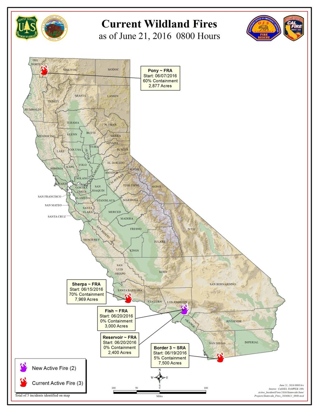
21 Number of fires and acres: Interval Fires Acres January 1, 2016 through December 31, , ,373 January 1, 2015 through December 31, , ,560 5 year average (same interval) 4, , Combined YTD (CALFIRE & US Forest Service) 6, ,835 (Statistics include all wildfires responded by CAL FIRE in both the State Responsibility Area, as well as the Local Responsibility Area under contract with the department, plus all large wildfires in State Responsibility Area protected by CAL FIRE s contract counties). FMAG Declarations to date: 13 Soberanes most expensive fire in U.S. history Estimated Cost to date: $208,406, Fires to Date CalOES AGOL 2016 Wildland Fires
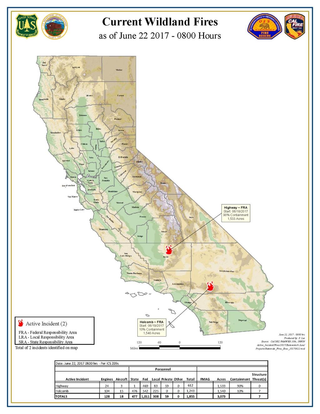
22 Number of fires and acres: Interval Fires Acres January 1, 2017 through June 3, ,339 16,036 January 1, 2016 through June 3, ,166 6,848 5 year average (same interval) 1,472 11, Combined YTD (CALFIRE & US Forest Service) 1,472 18,612 (Statistics include all wildfires responded by CAL FIRE in both the State Responsibility Area, as well as the Local Responsibility Area under contract with the department, plus all large wildfires in State Responsibility Area protected by CAL FIRE s contract counties). FMAG Declarations to date: Fires to Date Comparison
23
24
25 Thank you! Lorenzo Gigliotti Deputy Chief Cal OES Fire/Rescue (916)
Spring Water Supply and Weather Outlook How about that near Miracle March?
 Spring Water Supply and Weather Outlook How about that near Miracle March? tim.bardsley@noaa.gov NWS Reno 4.10.18 1 Out the Window March and early April have been Boom not Bust Key Points Up Front Wet
National Wildland Significant Fire Potential Outlook
 National Wildland Significant Fire Potential Outlook National Interagency Fire Center Predictive Services Issued: September, 2007 Wildland Fire Outlook September through December 2007 Significant fire
California OES Weather Threat Briefing
 California OES Weather Threat Briefing Wednesday, January 16, 2019 9:00 AM PST Day 1: Strong winds, heavy mountain snow and heavy rain with isolated thunderstorms across much of the state through Thursday
National Wildland Significant Fire Potential Outlook
 National Wildland Significant Fire Potential Outlook National Interagency Fire Center Predictive Services Issued: April 1, 2008 Next Issue: May 1, 2008 Wildland Fire Outlook April 2008 through July 2008
Issued by: National Weather Service San Joaquin Valley - Hanford CA. Issue time: 409 AM PST Wed Jan
 Forecast Information Location: New_Exchequer_Dam Updated: January 16, 2019, 11:45 am NWS Weather Discussion: Issued by: National Weather Service San Joaquin Valley - Hanford CA Issue time: 409 AM PST Wed
MULTI-AGENCY COORDINATION SYSTEM PUBLICATION CALIFORNIA FIRE WEATHER PROGRAM RISK PREPAREDNESS GUIDE MACS 410-3
 MULTI-AGENCY COORDINATION SYSTEM PUBLICATION CALIFORNIA FIRE WEATHER PROGRAM RISK PREPAREDNESS GUIDE MACS 410-3 August 26, 2013 California Fire Weather Program Risk Preparedness Guide Table of Contents
CALIFORNIA GOVERNOR'S OFFICE OF EMERGENCY SERVICES CAL OES CALIFORNIA DEPARTMENT OF FORESTRY AND FIRE PROTECTION CAL FIRE
 CALIFORNIA GOVERNOR'S OFFICE OF EMERGENCY SERVICES CAL OES CALIFORNIA DEPARTMENT OF FORESTRY AND FIRE PROTECTION CAL FIRE California Joint Incident Briefing 7/4/28 4: hours Weather Report - Northern Region
2011 National Seasonal Assessment Workshop for the Eastern, Southern, & Southwest Geographic Areas
 2011 National Seasonal Assessment Workshop for the Eastern, Southern, & Southwest Geographic Areas On January 11-13, 2011, wildland fire, weather, and climate met virtually for the ninth annual National
The hydrologic service area (HSA) for this office covers Central Kentucky and South Central Indiana.
 for this office covers Central Kentucky and South Central Indiana.") January 2012 February 13, 2012 An X inside this box indicates that no flooding occurred within this hydrologic service area. January 2012 continued the string of wet months this winter. Rainfall was generally
January 2012 February 13, 2012 An X inside this box indicates that no flooding occurred within this hydrologic service area. January 2012 continued the string of wet months this winter. Rainfall was generally
2008 California Fire Season Outlook
 2008 California Fire Season Outlook For July through October 2008 (issued 6/25/08) 1 North Ops Concerns and Implications for Management NOPS currently in a worsening drought, due to the driest spring on
A Prepared Marylander Creates a Resilient Maryland
 Maryland Emergency Management Agency Operations Directorate Hazardous Winter Weather Outlook Briefing March 5, 2013 0800 A Prepared Marylander Creates a Resilient Maryland A strong low pressure will track
IWT Scenario 1 Integrated Warning Team Workshop National Weather Service Albany, NY October 31, 2014
 Integrated Warning Team Workshop National Weather Service Albany, NY October 31, 2014 23 24 25 26 27 Scenario 1 Timeline November 23-27 Sun Mon Tue Wed Thu Thanksgiving Day Sunday, Nov. 23 @ 430 pm NWS
Weather Report 05 January 2018
 Weather Report 05 January 2018 South Africa - Weather Crop conditions will remain generally favorable across eastern South Africa during the next two weeks. Net drying will gradually reduce soil moisture,
Major Winter Storm to impact Western Washington. 17 January 2012 National Weather Service Seattle/Tacoma
 Major Winter Storm to impact Western Washington 17 January 2012 National Weather Service Seattle/Tacoma Current Warnings Winter Storm Warning for all of Western Washington, except: Northwest interior Extreme
TFS WEATHER BRIEF. Monday, March 25
 TFS WEATHER BRIEF Monday, March 25 Review: The leading edge of cooler and drier air was pushing through Central and East TX this morning. A few lingering thunderstorms were in progress south of I-20 in
Weather and Climate Summary and Forecast August 2018 Report
 Weather and Climate Summary and Forecast August 2018 Report Gregory V. Jones Linfield College August 5, 2018 Summary: July 2018 will likely go down as one of the top five warmest July s on record for many
California OES Atmospheric River Events Weather Threat Briefing
 California OES Atmospheric River Events Weather Threat Briefing 23 February 2017 10:00 AM PST Day 1: Flooding continues along small streams and creeks and some main stem rivers. National Weather Service
CropCast Corn and Soybean Report Kenny Miller Tuesday, March 14, 2017
 Accumulated Rainfall (inches) Accumulated GDDs Temperature ( F)/Wind Speed (mph) Precipitation (inches) CropCast Corn and Soybean Report Kenny Miller Tuesday, March 14, 2017 Peoria, IL Regional Forecast
National Situation Report As of 5:00 a.m. EDT Tuesday, April 4, 2017
 Overview National Situation Report As of 5:00 a.m. EDT Tuesday, April 4, 2017 Table Of Contents Current Operations Monitoring Recovery National Response Coordination Center: Not Activated National Watch
IWT Scenario 2 Integrated Warning Team Workshop National Weather Service Albany, NY October 31, 2014
 IWT Scenario 2 Integrated Warning Team Workshop National Weather Service Albany, NY October 31, 2014 09 10 11 12 13 Scenario 2 Timeline December 9-13 Tue Wed Thu Fri Sat Tue, Dec. 9 @ 5 am 2014 2014 2014
Weather and Climate Summary and Forecast Summer 2017
 Weather and Climate Summary and Forecast Summer 2017 Gregory V. Jones Southern Oregon University August 4, 2017 July largely held true to forecast, although it ended with the start of one of the most extreme
CropCast Corn and Soybean Report Kenny Miller Friday, March 17, 2017
 Accumulated Rainfall (inches) Accumulated GDDs Temperature ( F)/Wind Speed (mph) Precipitation (inches) CropCast Corn and Soybean Report Kenny Miller Friday, March 17, 2017 Peoria, IL Regional Forecast
Winter Storm Update. Through Late Afternoon: Jacksonville, FL Weather Forecast Office. Northeast Florida and Southeast Georgia
 Winter Storm Update Through Late Afternoon: Winter Storm Warning for all of Southeast GA and portions of Suwannee Valley and I-10 Corridor west of Jacksonville. Dangerous ice storm expected from Live Oak
Weekly Weather Briefing. NWS Albuquerque. Tuesday Soaker. NWS Albuquerque August 25, Weekly Weather Briefing
 Weekly Weather Briefing Weekly Weather Briefing Tuesday Soaker August 25, 2014 August 2014 vs. 2013 Precipitation Percent of Average August 1-24, 2014 August 2013 Weekly Weather Briefing ABQ **Preliminary**
Winter Weather Threat Friday night and Saturday January 7, 2017
 Winter Weather Threat Friday night and Saturday January 7, 2017 National Weather Service Newport/Morehead City, NC Date/Time Created: 1/6/2017, 6 AM EST Winter Weather Threat Summary Tonight and Saturday
Jan 7, 2017 Winter Weather Event
 Jan 7, 2017 Winter Weather Event Decision Support Briefing # 5 Assessment for northeast South Carolina & southeast North Carolina National Weather Service Wilmington NC 4 PM EST Friday January 6, 2017
Jan 7, 2017 Winter Weather Event
 Jan 7, 2017 Winter Weather Event Decision Support Briefing # 4 Assessment for northeast South Carolina & southeast North Carolina National Weather Service Wilmington NC 8 AM EST Friday January 6, 2017
2011 Year in Review TORNADOES
 2011 Year in Review The year 2011 had weather events that will be remembered for a long time. Two significant tornado outbreaks in April, widespread damage and power outages from Hurricane Irene in August
HURRICANE HARVEY COE Navigation BRIEFING
 HURRICANE HARVEY COE Navigation BRIEFING 10:00 AM CDT Friday, August 25, 2017 NWSNewOrleans www.weather.gov/neworleans Situation Overview New Information Harvey continues to strengthen Max sustained winds
UNITED STATES AND SOUTH AMERICA OUTLOOK (FULL REPORT) Tuesday, December 19, 2017
 Tuesday, December 19, 2017") T-storm Weather Summary A series of cool fronts move across South America over the next 10 to 14 days, breaking drying across much of Argentina, southern Brazil, and Paraguay. That said, in Argentina,
T-storm Weather Summary A series of cool fronts move across South America over the next 10 to 14 days, breaking drying across much of Argentina, southern Brazil, and Paraguay. That said, in Argentina,
Forecasting Challenges
 Forecasting Challenges 2017-18 Alex Tardy- NWS San Diego Alexander.Tardy@noaa.gov CW3E meetings April 2018 Atmospheric Rivers Climate Forecast System by NOAA 100-h fuel moisture all-time low for South
TROPICAL STORM HARVEY COE Navigation Call - Update
 TROPICAL STORM HARVEY COE Navigation Call - Update 10:00 AM CDT Tuesday, August 29, 2017 Prepared by: NWS LIX NWSNewOrleans www.weather.gov/neworleans Situation Overview New Information Drifting ENE at
Climate versus Weather
 Climate versus Weather What is climate? Climate is the average weather usually taken over a 30-year time period for a particular region and time period. Climate is not the same as weather, but rather,
Weather and Climate Summary and Forecast October 2018 Report
 Weather and Climate Summary and Forecast October 2018 Report Gregory V. Jones Linfield College October 4, 2018 Summary: Much of Washington, Oregon, coastal California and the Bay Area and delta region
MARKET WIRE. Jason Vollmer (701) Trygg Olson (701) Nick Smith (701) Adam Allmaras (701)
 Trygg Olson (701) Nick Smith (701) Adam Allmaras (701)") MARKET WIRE Quick Notes: New news in the corn market is limited. Markets continue to see spillover from Friday s USDA report. Carryout was unchanged in Friday s report and exports continue to remain sluggish.
MARKET WIRE Quick Notes: New news in the corn market is limited. Markets continue to see spillover from Friday s USDA report. Carryout was unchanged in Friday s report and exports continue to remain sluggish.
W I N T E R STORM HAZARD DESCRIPTION
 W I N T E R STORM HAZARD DESCRIPTION... 1 LOCATION... 2 EXTENT... 2 HISTORICAL OCCURRENCES... 4 SIGNIFICANT PAST EVENTS... 4 PROBABILITY OF FUTURE EVENTS... 5 VULNERABILITY AND IMPACT... 5 HAZARD DESCRIPTION
Weather and Climate Summary and Forecast November 2017 Report
 Weather and Climate Summary and Forecast November 2017 Report Gregory V. Jones Linfield College November 7, 2017 Summary: October was relatively cool and wet north, while warm and very dry south. Dry conditions
Weather Report 04 April 2018
 Weather Report 04 April 2018 South Africa - Weather Alternating periods of rain and sunshine will evolve across South Africa during the coming week. Moisture totals through next Tuesday morning will range
Winter Storm Tomorrow-Tomorrow Night
 Winter Storm Tomorrow-Tomorrow Night Decision Support Briefing #1 As of 4:30 PM Tuesday, February 19, 2019 What Has Changed? Initial Briefing Main Points Hazard Impacts Location Timing Snow Snow will create
3) What is the difference between latitude and longitude and what is their affect on local and world weather and climate?
 What is the difference between latitude and longitude and what is their affect on local and world weather and climate?") www.discoveryeducation.com 1) Describe the difference between climate and weather citing an example of each. Describe how water (ocean, lake, river) has a local effect on weather and climate and provide
www.discoveryeducation.com 1) Describe the difference between climate and weather citing an example of each. Describe how water (ocean, lake, river) has a local effect on weather and climate and provide
CropCast Corn and Soybean Report Kenny Miller Monday, March 13, 2017
 Accumulated Rainfall (inches) Accumulated GDDs Temperature ( F)/Wind Speed (mph) Precipitation (inches) CropCast Corn and Soybean Report Kenny Miller Monday, March 13, 2017 Peoria, IL Regional Forecast
Weather Report 30 November 2017
 Weather Report 30 November 2017 South Africa - Weather The frequent precipitation pattern will continue for portions of eastern and central South Africa during the coming week. Moisture totals through
DEPARTMENT OF EARTH & CLIMATE SCIENCES Name SAN FRANCISCO STATE UNIVERSITY Nov 29, ERTH 360 Test #2 200 pts
 DEPARTMENT OF EARTH & CLIMATE SCIENCES Name SAN FRANCISCO STATE UNIVERSITY Nov 29, 2018 ERTH 360 Test #2 200 pts Each question is worth 4 points. Indicate your BEST CHOICE for each question on the Scantron
The Pennsylvania Observer
 The Pennsylvania Observer September 3, 2008 Summer 2008 Weather Summary Written by: Brian Thompson The opening days of June started dry, but a warm front brought a widespread rain a couple of days into
Tropical Moist Rainforest
 Tropical or Lowlatitude Climates: Controlled by equatorial tropical air masses Tropical Moist Rainforest Rainfall is heavy in all months - more than 250 cm. (100 in.). Common temperatures of 27 C (80 F)
Atmospheric River Simulation
 Atmospheric River Simulation One of the most impressive AR setups forecasters have seen in years Saturday AM Saturday PM Sunday AM Sunday PM Peak intensity! Integrated Vapor Transport (wind energy + moisture)
Weekly Weather Briefing. NWS Albuquerque. Severe Threat Central & East through Tonight, then Drying. NWS Albuquerque September 29, 2014
 Severe Threat Central & East through Tonight, then Drying September 29, 2014 Today s Max Temp Departure from Normal Notable Severe Weather Events in September* September 30, 1998 Los Lunas: 4.5 Hail*
DISCUSSION --1/ 4 /19
 ISSUED: 4 JNURY 1715 EST WXRISK VIDEO WINTER FORECST short version WXRISK VIDEO WINTER FORECST Long version DISCUSSION --1/ 4 /19 *** STRONG SIGNS OF RETURN TYPICL JNURY TEMPS... DEVELOPING FTER JN 9 ***
Arizona Climate Summary May 2012
 Arizona Climate Summary May 2012 Summary of conditions for April 2012 April 2012 Temperature and Precipitation Summary April 1 st 16 th : Although April began with another low pressure system sweeping
Weather Report 29 November 2017
 Weather Report 29 November 2017 South Africa - Weather The erratic rain pattern will continue for portions of eastern and central India during the coming week. Moisture totals through next Tuesday morning
World Geography Chapter 3
 World Geography Chapter 3 Section 1 A. Introduction a. Weather b. Climate c. Both weather and climate are influenced by i. direct sunlight. ii. iii. iv. the features of the earth s surface. B. The Greenhouse
Oregon Water Conditions Report April 17, 2017
 Oregon Water Conditions Report April 17, 2017 Mountain snowpack continues to maintain significant levels for mid-april. By late March, statewide snowpack had declined to 118 percent of normal after starting
CropCast Corn and Soybean Report Kyle Tapley Monday, March 20, 2017
 Accumulated Rainfall (inches) Accumulated GDDs Temperature ( F)/Wind Speed (mph) Precipitation (inches) CropCast Corn and Soybean Report Kyle Tapley Monday, March 20, 2017 Peoria, IL Regional Forecast
Weather and Climate Summary and Forecast February 2018 Report
 Weather and Climate Summary and Forecast February 2018 Report Gregory V. Jones Linfield College February 5, 2018 Summary: For the majority of the month of January the persistent ridge of high pressure
TROPICAL STORM HARVEY BRIEFING
 TROPICAL STORM HARVEY BRIEFING 10:00 AM CDT Sunday, August 27, 2017 Prepared by: NWS LIX NWSNewOrleans www.weather.gov/neworleans Situation Overview New Information Tropical Storm Winds 40mph Immediate
May 2016 Volume 23 Number 5
 The Weather Wire May 2016 Volume 23 Number 5 Contents: Winter Summary Current Colorado and West-wide Snow Pack Drought Monitor April Summary/Statistics May Preview Snowfall Totals Winter Summary The Front
The Weather Wire. Contents: Summer 2018 Outlook. Summer 2018 Outlook Drought Monitor May Summary/Statistics June Preview Rainfall Totals
 The Weather Wire June 2018 Volume 25 Number 6 Contents: Summer 2018 Outlook Drought Monitor May Summary/Statistics June Preview Rainfall Totals Summer 2018 Outlook June 1 st marked the first day of meteorological
Fundamentals of Transmission Operations
 Fundamentals of Transmission Operations Load Forecasting and Weather PJM State & Member Training Dept. PJM 2014 9/10/2013 Objectives The student will be able to: Identify the relationship between load
WeatherManager Weekly
 Issue 288 July 14, 2016 WeatherManager Weekly Industries We Serve Agriculture Energy/Utilities Construction Transportation Retail Our Weather Protection Products Standard Temperature Products Lowest Daily
NIDIS Drought and Water Assessment
 NIDIS Drought and Water Assessment PRECIPITATION The images above use daily precipitation statistics from NWS COOP, CoCoRaHS, and CoAgMet stations. From top to bottom, and left to right: most recent 7-days
Significant Coastal Storm Today through Thursday, 11/7-8. Weather Briefing
 Significant Coastal Storm Today through Thursday, 11/7-8 Weather Briefing Prepared 10:00 am EST Wednesday, November 7, 2012 Presented by Gary Conte, Warning Coordination Meteorologist NOAA s National Weather
UNITED STATES AND SOUTH AMERICA OUTLOOK (FULL REPORT) Wednesday, April 18, 2018
 Wednesday, April 18, 2018") T-storm Weather Summary Coolness continues over the next week in much of the central U.S., most likely producing the coldest April since 1907 in the Corn Belt, but followed by seasonable to mild weather
T-storm Weather Summary Coolness continues over the next week in much of the central U.S., most likely producing the coldest April since 1907 in the Corn Belt, but followed by seasonable to mild weather
NOAA s National Weather Service Philadelphia/Mt. Holly NJ. Summary. Changes
 Summary A crippling and potentially historic east coast snow storm will lead to blizzard conditions and major coastal flooding for portions of the area this weekend. Changes Blizzard Warning has been expanded
CW3E Atmospheric River Update and Outlook
 Summary by C. Hecht and F.M. Ralph 3 PM PT Thurs 19 Jan. 2017 CW3E Atmospheric River Update and Outlook Update on 3 ARs Forecast to Impact the West Coast Over Next Several Days - AR 1 made landfall over
Weather and Climate Summary and Forecast March 2018 Report
 Weather and Climate Summary and Forecast March 2018 Report Gregory V. Jones Linfield College March 7, 2018 Summary: The ridge pattern that brought drier and warmer conditions from December through most
Weekly Weather Briefing. NWS Albuquerque. Wet, Then Dry, Then Wet. NWS Albuquerque August 4, Weekly Weather Briefing
 Weekly Weather Briefing Weekly Weather Briefing Wet, Then Dry, Then Wet August 4, 2014 Weekly Weather Briefing Most Recent Temperatures Weekly Weather Briefing Today s Max Temp Departure from Normal Weekly
MIAMI-SOUTH FLORIDA National Weather Service Forecast Office
 MIAMI-SOUTH FLORIDA National Weather Service Forecast Office http://www.weather.gov/miami June 2015 South Florida Weather Summary Dry East, Wet West...Drought Remains SE Florida July 3, 2015: Depending
Weather Briefing for Pennsylvania January 5-8, 2014 Prepared 01/05/14 (1:30 PM EST)
") Weather Briefing for Pennsylvania January 5-8, 2014 Prepared 01/05/14 (1:30 PM EST) Prepared by: National Weather Service State College, PA (john.lacorte@noaa.gov) Latest Radar Latest Surface Weather Plots
Weather Briefing for Pennsylvania January 5-8, 2014 Prepared 01/05/14 (1:30 PM EST) Prepared by: National Weather Service State College, PA (john.lacorte@noaa.gov) Latest Radar Latest Surface Weather Plots
Monthly Long Range Weather Commentary Issued: February 15, 2015 Steven A. Root, CCM, President/CEO
 Monthly Long Range Weather Commentary Issued: February 15, 2015 Steven A. Root, CCM, President/CEO sroot@weatherbank.com JANUARY 2015 Climate Highlights The Month in Review During January, the average
TROPICAL STORM HARVEY BRIEFING
 TROPICAL STORM HARVEY BRIEFING 2:00 PM CDT Tuesday, August 29, 2017 Prepared by: NWS LIX NWSNewOrleans www.weather.gov/neworleans Situation Overview New Information Moving NNE Max sustained wind 45 mph
Weather Briefing. Coastal Storm Monday-Wednesday Dec 8-10, National Weather Service. Prepared 12/8/14 6:30 AM
 Weather Briefing Coastal Storm Monday-Wednesday Dec 8-10, 2014 National Weather Service http://www.weather.gov/nyc Prepared 12/8/14 6:30 AM Overview of Potential Hazards A strong low pressure system will
January 2008 Climate Summary
 Joseph Mays (765) 494-6574 Feb 5, 2008 http://www.iclimate.org Summary January 2008 Climate Summary January was a mix bag of conditions, with an oscillatory pattern developing. We experienced phases of
-Assessment of current water conditions. - Precipitation Forecast. - Recommendations for Drought Monitor
 April 27, 2010 -Assessment of current water conditions - Precipitation Forecast - Recommendations for Drought Monitor 7 Day Precipitation 19-25 April 2010 Month-to-Date Precipitation 1-25 April 2010
Chapter 1 Study Guide
 Chapter 1 Study Guide Reminders: Vocabulary quiz and test will be on Tuesday, September 6th. Complete study guide and bring completed to school Friday, September 2nd. You are NOT required to print the
UNITED STATES AND SOUTH AMERICA SNAPSHOT REPORT Thursday, December 21, 2017
 T-storm Weather Summary A small but key corn and soybean area in western Argentina was wetter than expected overnight. T-storms affect varying areas of South America at varying times into January, but
CW3E Atmospheric River Update Outlook Strong AR forecast to impact California this weekend - A strong AR with IVT as high as 1000 kg m -1 s -1 is
 CW3E Atmospheric River Update Outlook Strong AR forecast to impact California this weekend - A strong AR with IVT as high as 1000 kg m -1 s -1 is forecast make landfall over the West Coast this Weekend
Colorado CoCoRaHS. Colorado CoCoRaHS. December 2013 Volume 1, Issue 8 NOVEMBER PRECIPITATION NOVEMBER TEMPERATURES
 NOVEMBER PRECIPITATION The month of November brought a flip-flop in precipitation patterns to some areas compared to the previous month, especially for locations in the foothills north of I-70 and in south-central
Potentially Wet Wed-Fri
 Potentially Wet Wed-Fri August 18, 2014 Last Week s Lightning Trends TUE 8/12 WED 8/13 THU 8/14 FRI 8/15 t SAT 8/16 SUN 8/17 August 1-16 Precipitation Anomaly: 2013 VS. 2014 AUG 1-16, 2013 AUG 1-16, 2014
Monthly Long Range Weather Commentary Issued: July 18, 2014 Steven A. Root, CCM, President/CEO
 Monthly Long Range Weather Commentary Issued: July 18, 2014 Steven A. Root, CCM, President/CEO sroot@weatherbank.com JUNE 2014 REVIEW Climate Highlights The Month in Review The average temperature for
Rooster Comb Ridge Cornice Incident
 Rooster Comb Ridge Cornice Incident April 3, 2011 Date/time: Sunday, April 3, 2011 / ~12:45pm PDT Submitted by: Patty Morrison Stevens Pass Winter Resort Snow Safety; Mark Moore NWAC Place: High point
Weather and Climate Summary and Forecast October 2017 Report
 Weather and Climate Summary and Forecast October 2017 Report Gregory V. Jones Linfield College October 4, 2017 Summary: Typical variability in September temperatures with the onset of fall conditions evident
Oregon Water Conditions Report May 1, 2017
 Oregon Water Conditions Report May 1, 2017 Mountain snowpack in the higher elevations has continued to increase over the last two weeks. Statewide, most low and mid elevation snow has melted so the basin
Weather and Climate of the Rogue Valley By Gregory V. Jones, Ph.D., Southern Oregon University
 Weather and Climate of the Rogue Valley By Gregory V. Jones, Ph.D., Southern Oregon University The Rogue Valley region is one of many intermountain valley areas along the west coast of the United States.
NIDIS Intermountain West Drought Early Warning System April 18, 2017
 1 of 11 4/18/2017 3:42 PM Precipitation NIDIS Intermountain West Drought Early Warning System April 18, 2017 The images above use daily precipitation statistics from NWS COOP, CoCoRaHS, and CoAgMet stations.
Weather and Climate 1. Elements of the weather
 Weather and Climate 1 affect = to have an effect on, influence, change altitude = the height of a place above the sea axis = the line around which an object rotates certain = special consist of = to be
Weather Briefing for Pennsylvania Feb Outlook Prepared 02/11/14 2 pm EST
 Weather Briefing for Pennsylvania Feb. 12-13 Outlook Prepared 02/11/14 2 pm EST Prepared by: National Weather Service State College, PA (Peter.Jung@noaa.gov) Pennsylvania Weather Overview A significant
NatGasWeather.com Daily Report
 NatGasWeather.com Daily Report Issue Time: 5:15 pm EST Sunday, February 28 th, 2016 for Monday, Feb 29 th 7-Day Weather Summary (February 28 th March 5 th ): High pressure will dominate much of the US
Climate Change in Colorado: Recent Trends, Future Projections and Impacts An Update to the Executive Summary of the 2014 Report
 Climate Change in Colorado: Recent Trends, Future Projections and Impacts An Update to the Executive Summary of the 2014 Report Jeff Lukas, Western Water Assessment, University of Colorado Boulder - Lukas@colorado.edu
NatGasWeather.com Daily Report
 NatGasWeather.com Daily Report Issue Time: 5:15 am EDT Wednesday, March 22 nd, 2017 1-7 Day Weather Summary (Mar 22-28 th ): A cold blast will sweep across the Great Lakes and eastern US today and Thursday
PRECIPITATION. Last Week Precipitation:
 12/3/2014 NIDIS Drought and Water Assessment PRECIPITATION The images above use daily precipitation statistics from NWS COOP, CoCoRaHS, and CoAgMet stations. From top to bottom, and left to right: most
Introduction to Numerical Weather Prediction. Mike Leuthold Atmo 336
 Introduction to Numerical Weather Prediction Mike Leuthold Atmo 336 Model Components This flowchart, starting at the bottom, shows how the components of Numerical Weather Prediction (NWP) and how it fits
The Pennsylvania Observer
 The Pennsylvania Observer January 5, 2009 December 2008 Pennsylvania Weather Recap The final month of 2008 was much wetter than average and a bit colder than normal. In spite of this combination, most
Hurricane Harvey: SE Texas Impacts. 10 AM CDT UPDATE Saturday, August 26, 2017 Prepared by: Dan Reilly, Brian Kyle
 Hurricane Harvey: SE Texas Impacts 10 AM CDT UPDATE Saturday, August 26, 2017 Prepared by: Dan Reilly, Brian Kyle Latest Observations and Radar Hurricane Harvey centered near Victoria and weakening Wind
Weather and Climate Summary and Forecast Winter
 Weather and Climate Summary and Forecast Winter 2016-17 Gregory V. Jones Southern Oregon University February 7, 2017 What a difference from last year at this time. Temperatures in January and February
1 What Is Climate? TAKE A LOOK 2. Explain Why do areas near the equator tend to have high temperatures?
 CHAPTER 3 1 What Is Climate? SECTION Climate BEFORE YOU READ After you read this section, you should be able to answer these questions: What is climate? What factors affect climate? How do climates differ
NIDIS Intermountain West Drought Early Warning System October 17, 2017
 NIDIS Drought and Water Assessment NIDIS Intermountain West Drought Early Warning System October 17, 2017 Precipitation The images above use daily precipitation statistics from NWS COOP, CoCoRaHS, and
Monthly Long Range Weather Commentary Issued: APRIL 18, 2017 Steven A. Root, CCM, Chief Analytics Officer, Sr. VP,
 Monthly Long Range Weather Commentary Issued: APRIL 18, 2017 Steven A. Root, CCM, Chief Analytics Officer, Sr. VP, sroot@weatherbank.com MARCH 2017 Climate Highlights The Month in Review The average contiguous
Unit 4 Review Guide: Weather
 Unit 4 Review Guide: Weather Weather: The condition of the atmosphere at a specific time and place. Freezing: To become hardened into ice or into a solid body Deposition: The change in state of matter
The Colorado Drought of 2002 in Perspective
 The Colorado Drought of 2002 in Perspective Colorado Climate Center Nolan Doesken and Roger Pielke, Sr. Prepared by Tara Green and Odie Bliss http://climate.atmos.colostate.edu Known Characteristics of
Contents. Section 1: Climate Factors. Section 2: Climate Types. Section 3: Climate Effects
 Contents Section 1: Climate Factors 1. Weather or Climate?.... 2 2. Elements of Climate.... 4 3. Factors Affecting Climate.... 10 4. Comparing Climates.... 15 5. Quiz 1.... 20 Section 2: Climate Types