Issued by: National Weather Service San Joaquin Valley - Hanford CA. Issue time: 409 AM PST Wed Jan
|
|
|
- Annice Knight
- 5 years ago
- Views:
Transcription

1 Forecast Information Location: New_Exchequer_Dam Updated: January 16, 2019, 11:45 am NWS Weather Discussion: Issued by: National Weather Service San Joaquin Valley - Hanford CA Issue time: 409 AM PST Wed Jan SYNOPSIS... One more storm system will move through the central California interior today and Thursday bringing periods of rain, mountain snow, and gusty winds. Much of Friday through Sunday will be dry with patchy night and morning fog in the San Joaquin Valley. A weak disturbance will move through later Sunday afternoon and Sunday night, followed by dry weather next week. &&.DISCUSSION... A few showers have continued in the Sierra Nevada overnight. There will be a short break in the precipitation across most of the district before the next system begins to move into the region by this afternoon. This system is the last in a series of systems to move through the region over the past several days, and it looks to be wetter for central California than the previous ones. This system has been well advertised by the models and has a good fetch of moisture with it. It will also bring gusty southerly winds with it. Although some light precipitation will begin over the region this afternoon, the bulk of the precipitation will not begin until late afternoon/early evening and will be heaviest overnight into Thursday morning. A winter storm warning remains in effect for the Sierra Nevada from 4 pm today through 10 PM Thursday. Snow levels will begin around 5500 to 6000 feet this afternoon, rising to 7000 feet by this evening. Snow level will rise to near or slightly above 8000 feet late tonight before lowering back down to 7000 feet after the cold front moves through by mid day Thursday. Snow amounts will be up to 4 feet over the Sierra Nevada. With this system being warmer and farther north than the last two systems that came through, the Kern County mountains will see primarily rain with this system. Some snow is possible above 6000 feet Thursday night as the system is coming to an end. While heavy snow falls over the Sierra Nevada, heavy rain will fall over the lower elevations. Rainfall amounts are expected to be a half inch to around an inch over much of the San Joaquin Valley, 1 to 1.5 inches in the Kern County Mountains and about a half inch in the Kern Desert areas. Rain fall amounts of 2 to 4 inches with local amounts up to 5 inches are possible in the Sierra Foothills and Sierra Nevada below 7000 feet. This will create a significant risk of flooding and potentially debris flow in the recent burn scars, especially the Ferguson and Pier fire areas. A Flash Flood Watch remains in effect. Wind is the other concern with this storm system. As it approaches today, southerly winds will increase, especially from Fresno County northward. A wind advisory remains in place for the San Joaquin Valley and Foothills from Fresno county northward where winds could gust above 35 mph this afternoon through tonight. Strong winds will also occur over the higher elevations of the Sierra. Once this system exits the region Thursday night, a few residual showers will remain in the Kern Mountains through Friday morning and skies will gradually clear as high pressure builds over the region. Friday afternoon through Sunday morning will be dry with the potential for fog in the San Joaquin Valley in the late night and morning hours. A system riding over the top of the ridge will bring a chance of showers Sunday afternoon through Monday morning, then a stronger ridge of high pressure will build over the region for next week.
2 7-Day Forecasts: 7-day forecast [ Updated: Wednesday, 16 Jan :23 AM PST ] Day Summary High Temp Low Temp Wind/Dir Humidity Comfort Level UV Index 24hr. Precip. Precip. Prob. Wed Rain. Haze. Cool 57 F 51 F 14 mph / SE 80% 51 F Minimal 1.12" 75% Thu Rain. Haze. Cool 54 F 47 F 9 mph / S 86% 50 F Minimal 0.81" 77% Fri Cloudy. Cool 57 F 40 F 6 mph / NE 72% 54 F Minimal 3% Sat More sun than clouds. Cool 61 F 43 F 6 mph / E 76% 58 F Minimal 2% Sun Increasing cloudiness. Cool 62 F 43 F 9 mph / S 74% 58 F Minimal 7% Mon Morning clouds. Cool 55 F 34 F 10 mph / NW 67% 50 F Minimal 2% Tue More sun than clouds. Cool 56 F 30 F 5 mph / SE 70% 52 F Minimal 2% 70 Maximum Mean Minimum Temperature ( F) Wed,16 Jan 17 Jan 18 Jan 19 Jan 20 Jan Mon,21 Jan Tue,22 Jan Precip. Prob. (%) Precip. Prob. Wed,16 Jan 17 Jan 18 Jan 19 Jan 20 Jan Mon,21 Jan Tue,22 Jan 1.5 Precipitation Rainfall (") Wed,16 Jan 17 Jan 18 Jan 19 Jan 20 Jan Mon,21 Jan Tue,22 Jan Wind speed (mph) Wind Speed Wed,16 Jan 17 Jan 18 Jan 19 Jan 20 Jan Mon,21 Jan Tue,22 Jan
3 Detailed Forecast: Wednesday January 16, :45:04 AM PST Wednesday Thursday Afternoon Evening Night Morning Light rain. Haze. Cool. Rain. Overcast. Cool. Strong thunderstorms. Overcast. Cool. Light rain. Low clouds. Cool. Temperature 55 F 54 F 52 F 53 F Wind/Dir 16 mph / S 26 mph / SSE 24 mph / SSE 17 mph / ESE Wind Gust 22 mph 37 mph 34 mph 24 mph Humidity 86% 96% 96% 86% Dew point 51 F 53 F 51 F 49 F Comfort level 51 F 47 F 45 F 48 F Visibility 3.0 miles 2.0 miles 2.0 miles 2.0 miles 6Hr. Precip. Total 0.11" 0.29" 0.58" 0.11" Chance of precip. 91% 100% 100% 72% Thursday Friday Afternoon Evening Night Morning Light rain. Haze. Cool. Drizzle. Overcast. Cool. Dense fog. Chilly. Low clouds. Chilly. Temperature 57 F 49 F 41 F 41 F Wind/Dir 16mph / WNW 5mph / NNW 5mph / NNE 3mph / N Wind Gust 22 mph 37 mph 34 mph 24 mph Humidity 78% 89% 100% 96% Dew point 50 F 46 F 41 F 40 F Comfort level 54 F 48 F 38 F 39 F Visibility 3 miles 3 miles 0 miles 0 miles 6Hr. Precip. Total 0.11" <0.01" Chance of precip. 74% 30% 10% 6%


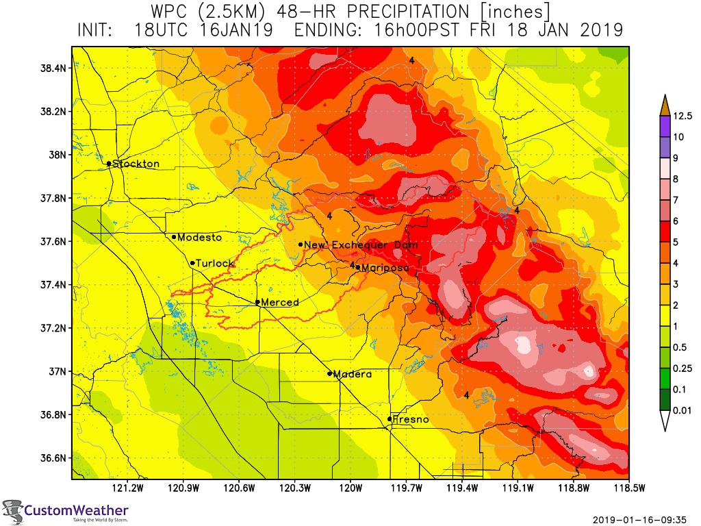
4 Maps: 6-Hr Weather Prediction Center (NOAA) Precipitation Forecast 24-Hr Weather Prediction Center (NOAA) Quantitative Precipitation Forecast 48-Hr Weather Prediction Center (NOAA) Quantitative Precipitation Forecast Total Period Weather Prediction Center (NOAA) Quantitative Precipitation Forecast
 0.14 0.1 0.06 0.")
5 Maps: 24-Hr USL Evapotranspiration Forecast 24-Hr USL Evapotranspiration Forecast 0.18 Evapotranspiration New Exchequer Dam, United States ETo (inches) Wed, 16Jan Wed, 16Jan Mon, 21Jan Mon, 21Jan
6 NWS Alerts & CW Advisories: NWS Alerts There are no NWS Alerts for your location! Anticipated advisories: Updated: Wednesday, 16 Jan :20 AM PST Day Time of Day Advisory Wed Morning Floods anticipated Wed Afternoon Floods anticipated Wed Evening Floods anticipated Wed Evening Floods anticipated Thu Morning Floods anticipated Thu Afternoon Floods anticipated Thu Evening Floods anticipated Thu Evening Floods anticipated Thu Evening Fog anticipated
California OES Weather Threat Briefing
 California OES Weather Threat Briefing Wednesday, January 16, 2019 9:00 AM PST Day 1: Strong winds, heavy mountain snow and heavy rain with isolated thunderstorms across much of the state through Thursday
IWT Scenario 1 Integrated Warning Team Workshop National Weather Service Albany, NY October 31, 2014
 Integrated Warning Team Workshop National Weather Service Albany, NY October 31, 2014 23 24 25 26 27 Scenario 1 Timeline November 23-27 Sun Mon Tue Wed Thu Thanksgiving Day Sunday, Nov. 23 @ 430 pm NWS
TFS WEATHER BRIEF. Monday, March 25
 TFS WEATHER BRIEF Monday, March 25 Review: The leading edge of cooler and drier air was pushing through Central and East TX this morning. A few lingering thunderstorms were in progress south of I-20 in
Spring Water Supply and Weather Outlook How about that near Miracle March?
 Spring Water Supply and Weather Outlook How about that near Miracle March? tim.bardsley@noaa.gov NWS Reno 4.10.18 1 Out the Window March and early April have been Boom not Bust Key Points Up Front Wet
Weekly Weather Briefing. NWS Albuquerque. Wet, Then Dry, Then Wet. NWS Albuquerque August 4, Weekly Weather Briefing
 Weekly Weather Briefing Weekly Weather Briefing Wet, Then Dry, Then Wet August 4, 2014 Weekly Weather Briefing Most Recent Temperatures Weekly Weather Briefing Today s Max Temp Departure from Normal Weekly
IWT Scenario 2 Integrated Warning Team Workshop National Weather Service Albany, NY October 31, 2014
 IWT Scenario 2 Integrated Warning Team Workshop National Weather Service Albany, NY October 31, 2014 09 10 11 12 13 Scenario 2 Timeline December 9-13 Tue Wed Thu Fri Sat Tue, Dec. 9 @ 5 am 2014 2014 2014
California OES Atmospheric River Events Weather Threat Briefing
 California OES Atmospheric River Events Weather Threat Briefing 23 February 2017 10:00 AM PST Day 1: Flooding continues along small streams and creeks and some main stem rivers. National Weather Service
A Prepared Marylander Creates a Resilient Maryland
 Maryland Emergency Management Agency Operations Directorate Hazardous Winter Weather Outlook Briefing March 5, 2013 0800 A Prepared Marylander Creates a Resilient Maryland A strong low pressure will track
CropCast Corn and Soybean Report Kenny Miller Monday, March 13, 2017
 Accumulated Rainfall (inches) Accumulated GDDs Temperature ( F)/Wind Speed (mph) Precipitation (inches) CropCast Corn and Soybean Report Kenny Miller Monday, March 13, 2017 Peoria, IL Regional Forecast
CropCast Corn and Soybean Report Kenny Miller Friday, March 17, 2017
 Accumulated Rainfall (inches) Accumulated GDDs Temperature ( F)/Wind Speed (mph) Precipitation (inches) CropCast Corn and Soybean Report Kenny Miller Friday, March 17, 2017 Peoria, IL Regional Forecast
CropCast Corn and Soybean Report Kyle Tapley Monday, March 20, 2017
 Accumulated Rainfall (inches) Accumulated GDDs Temperature ( F)/Wind Speed (mph) Precipitation (inches) CropCast Corn and Soybean Report Kyle Tapley Monday, March 20, 2017 Peoria, IL Regional Forecast
Weather Briefing. Coastal Storm Monday-Wednesday Dec 8-10, National Weather Service. Prepared 12/8/14 6:30 AM
 Weather Briefing Coastal Storm Monday-Wednesday Dec 8-10, 2014 National Weather Service http://www.weather.gov/nyc Prepared 12/8/14 6:30 AM Overview of Potential Hazards A strong low pressure system will
CW3E Atmospheric River Outlook Update on Atmospheric River Forecast to Impact California This Week - Light to moderate precipitation has begun
 CW3E Atmospheric River Outlook Update on Atmospheric River Forecast to Impact California This Week - Light to moderate precipitation has begun falling over portions of California - GFS Ensemble members
CropCast Corn and Soybean Report Kenny Miller Tuesday, March 14, 2017
 Accumulated Rainfall (inches) Accumulated GDDs Temperature ( F)/Wind Speed (mph) Precipitation (inches) CropCast Corn and Soybean Report Kenny Miller Tuesday, March 14, 2017 Peoria, IL Regional Forecast
WEEKLY WEATHER OUTLOOK BELIZE, CENTRAL AMERICA
 WEEKLY WEATHER OUTLOOK BELIZE, CENTRAL AMERICA PERIOD: Sunday, June 17 until Monday, June 25, 2012 DATE ISSUED: Sunday, June 17, 2012; 3:00 pm RFrutos EcoSolutions & Services SYNOPSIS: An upper level trough
Potentially Wet Wed-Fri
 Potentially Wet Wed-Fri August 18, 2014 Last Week s Lightning Trends TUE 8/12 WED 8/13 THU 8/14 FRI 8/15 t SAT 8/16 SUN 8/17 August 1-16 Precipitation Anomaly: 2013 VS. 2014 AUG 1-16, 2013 AUG 1-16, 2014
Significant Coastal Storm Today through Thursday, 11/7-8. Weather Briefing
 Significant Coastal Storm Today through Thursday, 11/7-8 Weather Briefing Prepared 10:00 am EST Wednesday, November 7, 2012 Presented by Gary Conte, Warning Coordination Meteorologist NOAA s National Weather
Severe Weather Watches, Advisories & Warnings
 Severe Weather Watches, Advisories & Warnings Tornado Watch Issued by the Storm Prediction Center when conditions are favorable for the development of severe thunderstorms and tornadoes over a larger-scale
Weekly Weather Briefing. NWS Albuquerque. Severe Threat Central & East through Tonight, then Drying. NWS Albuquerque September 29, 2014
 Severe Threat Central & East through Tonight, then Drying September 29, 2014 Today s Max Temp Departure from Normal Notable Severe Weather Events in September* September 30, 1998 Los Lunas: 4.5 Hail*
Coastal Storm. Wednesday through Friday, 3/6-8/2013 Weather Briefing
 Coastal Storm Wednesday through Friday, 3/6-8/2013 Weather Briefing Prepared 2:00 PM EST Wednesday, March 6, 2013 National Weather Service New York, NY Purpose of Briefing Promote Situational Awareness
TROPICAL STORM HARVEY COE Navigation Call - Update
 TROPICAL STORM HARVEY COE Navigation Call - Update 10:00 AM CDT Tuesday, August 29, 2017 Prepared by: NWS LIX NWSNewOrleans www.weather.gov/neworleans Situation Overview New Information Drifting ENE at
CW3E Atmospheric River Outlook
 CW3E Atmospheric River Outlook Update on Atmospheric River Forecast to Impact California This Week - Precipitation continues to fall across portions of California - The AR will begin to propagate southward
Weekly Weather Briefing. NWS Albuquerque. Tuesday Soaker. NWS Albuquerque August 25, Weekly Weather Briefing
 Weekly Weather Briefing Weekly Weather Briefing Tuesday Soaker August 25, 2014 August 2014 vs. 2013 Precipitation Percent of Average August 1-24, 2014 August 2013 Weekly Weather Briefing ABQ **Preliminary**
West Henrico Co. - Glen Allen Weather Center N W. - Koontz
 PAGE #1 Oct 2017 West Henrico Co. - Glen Allen Weather Center 37.6554 N. 77.5692 W. - Koontz 1 2 3 4 5 6 7 8 9 10 11 12 13 14 15 16 17 18 19 Oct Week TEMPERATURE F TEMPERATURE F SKY PRECIPITATION FROZ.
CW3E Atmospheric River Update and Outlook
 Summary by C. Hecht and F.M. Ralph 3 PM PT Thurs 19 Jan. 2017 CW3E Atmospheric River Update and Outlook Update on 3 ARs Forecast to Impact the West Coast Over Next Several Days - AR 1 made landfall over
Coastal Storm Potential
 Coastal Storm Potential Event Date/Time: 11/12/2009-11/14/2009 Today through Saturday National Weather Service Newport/Morehead City, NC Date: 11/12/2009 1000 am Coastal Storm Remnants of Ida, coupled
Significant Flooding Expected
 Significant Flooding Expected Decision Support Briefing #5 As of: 9:00 AM September 14, 2018 What Has Changed? Flash Flood Watch now in effect for part of area, will be expanded later today 9/14/2018 9:23
An upper to mid level circulation (Low) in the NW Caribbean is
 in the NW Caribbean is") WEEKLY WEATHER OUTLOOK BELIZE, CENTRAL AMERICA PERIOD: Monday-Monday, Oct. 1 October 8, 2012 DATE ISSUED: Monday, Oct 1, 2012 6:00 am RFrutos EcoSolutions & Services SYNOPSIS: An upper to mid level circulation
WEEKLY WEATHER OUTLOOK BELIZE, CENTRAL AMERICA PERIOD: Monday-Monday, Oct. 1 October 8, 2012 DATE ISSUED: Monday, Oct 1, 2012 6:00 am RFrutos EcoSolutions & Services SYNOPSIS: An upper to mid level circulation
WEEKLY WEATHER OUTLOOK BELIZE, CENTRAL AMERICA
 WEEKLY WEATHER OUTLOOK BELIZE, CENTRAL AMERICA PERIOD: Sunday, July 1 until Monday, July 9, 2012 DATE ISSUED: Sunday, July 1, 2012 3:00 pm RFrutos EcoSolutions & Services SYNOPSIS: The features of interest
Monday, October 19, CDT Brian Hoeth
 Monday, October 19, 2015 1400 CDT Brian Hoeth Some of the briefing presented is worstcase scenario and may differ in detail from local NWS Weather Forecast Offices. National Weather Service Southern Region
Jan 7, 2017 Winter Weather Event
 Jan 7, 2017 Winter Weather Event Decision Support Briefing # 5 Assessment for northeast South Carolina & southeast North Carolina National Weather Service Wilmington NC 4 PM EST Friday January 6, 2017
Winter Storm Update. Through Late Afternoon: Jacksonville, FL Weather Forecast Office. Northeast Florida and Southeast Georgia
 Winter Storm Update Through Late Afternoon: Winter Storm Warning for all of Southeast GA and portions of Suwannee Valley and I-10 Corridor west of Jacksonville. Dangerous ice storm expected from Live Oak
CW3E Atmospheric River Update Outlook Strong AR forecast to impact California this weekend - A strong AR with IVT as high as 1000 kg m -1 s -1 is
 CW3E Atmospheric River Update Outlook Strong AR forecast to impact California this weekend - A strong AR with IVT as high as 1000 kg m -1 s -1 is forecast make landfall over the West Coast this Weekend
Severe Weather Potential for Southeast Texas
 Severe Weather Potential for Southeast Texas Dan Reilly, Kent Prochazka, Scott Overpeck National Weather Service Houston/Galveston 10 am Synopsis Storm to likely bring severe weather to Southeast Texas
DEPARTMENT OF EARTH & CLIMATE SCIENCES Name SAN FRANCISCO STATE UNIVERSITY Nov 29, ERTH 360 Test #2 200 pts
 DEPARTMENT OF EARTH & CLIMATE SCIENCES Name SAN FRANCISCO STATE UNIVERSITY Nov 29, 2018 ERTH 360 Test #2 200 pts Each question is worth 4 points. Indicate your BEST CHOICE for each question on the Scantron
Forecasting Challenges
 Forecasting Challenges 2017-18 Alex Tardy- NWS San Diego Alexander.Tardy@noaa.gov CW3E meetings April 2018 Atmospheric Rivers Climate Forecast System by NOAA 100-h fuel moisture all-time low for South
FEMA RIX. Daily Situational Awareness Brief
 RIX Daily Situational Awareness Brief Monday, October 3, 2016 POC: Region IX Regional Watch Center 888-709-3362 fema-r9watchofficer@fema.dhs.gov CURRENT OPERATIONS STATUS OPERATIONS STATUS IMAT I AVAILABLE
WEEKEND WEATHER OUTLOOK BELIZE, CENTRAL AMERICA
 WEEKEND WEATHER OUTLOOK BELIZE, CENTRAL AMERICA PERIOD: Friday, July 13 until Monday, July 16, 2012 DATE ISSUED: Friday, June 13, 2012, 9:00 am RFrutos SYNOPSIS: A weak pressure gradient over the NW Caribbean
Atmospheric River Simulation
 Atmospheric River Simulation One of the most impressive AR setups forecasters have seen in years Saturday AM Saturday PM Sunday AM Sunday PM Peak intensity! Integrated Vapor Transport (wind energy + moisture)
LOCAL CLIMATOLOGICAL DATA Monthly Summary November 2006
 Deg. Days Precip Ty Precip Wind Sun Hu- Adj. to Sea Level mid- ity Avg Res Res Peak Minute 1 fog 2 hvy fog 3 thunder 4 ice plt 5 hail 6 glaze 7 duststm 8 smk, hz 9 blw snw 1 2 3 4A 4B 5 6 7 8 9 12 14 15
January 2006 Climate Summary
 Ashley Brooks (765) 494-6574 Feb 9, 2006 http://www.iclimate.org January 1-3 January 2006 Climate Summary Unseasonably warm conditions welcomed in the New Year with highs in the 40s across the northern
Tropical Storm Colin Briefing Last Briefing on this System
 Tropical Storm Colin Briefing Last Briefing on this System NWS WFO Jacksonville, Florida Tuesday, June 07, 2016 6:00 a.m. EDT Tropical Storm Colin s Impacts SE Georgia & North Florida Local Watches & Warnings:
Nor easter Monday Night Wednesday December 8 10, 2014
 Nor easter Monday Night Wednesday December 8 10, 2014 Prepared 400 PM EST Monday, December 8, 2014 Mitchell Gaines NOAA s Philadelphia/Mount Holly NJ Forecast Office www.weather.gov/phi/ Purpose of Briefing
Weather Briefing for Pennsylvania January 5-8, 2014 Prepared 01/05/14 (1:30 PM EST)
") Weather Briefing for Pennsylvania January 5-8, 2014 Prepared 01/05/14 (1:30 PM EST) Prepared by: National Weather Service State College, PA (john.lacorte@noaa.gov) Latest Radar Latest Surface Weather Plots
Weather Briefing for Pennsylvania January 5-8, 2014 Prepared 01/05/14 (1:30 PM EST) Prepared by: National Weather Service State College, PA (john.lacorte@noaa.gov) Latest Radar Latest Surface Weather Plots
Coastal Storm this Weekend
 Weather Briefing Prepared 9 AM EST Feb 5, 2010 Joe Miketta Warning Coordination Meteorologist NOAA s National Weather Service Philadelphia/Mt. Holly NJ Forecast Office 609-261 261-6602 6602 x223 Joseph.Miketta@noaa.gov
Tropical Storm Harvey: SE Texas Impacts. 10 AM CDT UPDATE Sunday August 27, 2017 Prepared by: Lance Wood
 Tropical Storm Harvey: SE Texas Impacts 10 AM CDT UPDATE Sunday August 27, 2017 Prepared by: Lance Wood Situation Overview Catastrophic flooding is ongoing with flash flood emergencies remaining in effect.
LOCAL CLIMATOLOGICAL DATA Monthly Summary July 2013
 Deg. Days Precip Ty Precip Wind Solar Hu- Adj. to Sea Level mid- ity Avg Res Res Peak Minute 1 fog 2 hvy fog 3 thunder 4 ice plt 5 hail 6 glaze 7 duststm 8 smk, hz 9 blw snw 1 2 3 4A 4B 5 6 7 8 9 12 14
'Day in the Life' Physical Data 10/18/11. RM : cm site tube. typical fall, sun, clouds, small rain mostly 1 South calm
 RM Site Time Time 24 hr clock Air Temp. C Air Temp. F RM 300 6:00 3.33 38 clear RM 200 10:07 12 52 cloudy RM 153 9:52 20 62 rain Weather Today Weather Last 3 days cool, slight rain, rain last night windy,
Hurricane Harvey: SE Texas Impacts. 10 AM CDT UPDATE Saturday, August 26, 2017 Prepared by: Dan Reilly, Brian Kyle
 Hurricane Harvey: SE Texas Impacts 10 AM CDT UPDATE Saturday, August 26, 2017 Prepared by: Dan Reilly, Brian Kyle Latest Observations and Radar Hurricane Harvey centered near Victoria and weakening Wind
LOCAL CLIMATOLOGICAL DATA Monthly Summary September 2016
 Deg. Days Precip Ty Precip Wind Solar Hu- Adj. to Sea Level mid- ity Avg Res Res Peak 2 Minute 1 fog 2 hvy fog 3 thunder 4 ice plt 5 hail 6 glaze 7 duststm 8 smk, hz 9 blw snw 1 2 3 4A 4B 5 6 7 8 9 11
2017 Fire Season Outlook
 2017 Fire Season Outlook Staring Nicolas Cage as Don Boland 6 Fire & Rescue Mutual Aid Regions 64 Operational Areas FIRESCOPE - SEMS/NIMS 154 Engines (114 Type I Engines, 40 Type III Engines) 12 Tactical
Tuesday, January 16, AM
 Tuesday, January 16, 2018 10 AM Weather Forecast Office Peachtree City, GA Disclaimer: The Information Contained within this Briefing is Time Sensitive, and Could Affect its Validity as the Date/Time Moves
TROPICAL STORM HARVEY BRIEFING
 TROPICAL STORM HARVEY BRIEFING 2:00 PM CDT Tuesday, August 29, 2017 Prepared by: NWS LIX NWSNewOrleans www.weather.gov/neworleans Situation Overview New Information Moving NNE Max sustained wind 45 mph
NOAA s National Weather Service Philadelphia/Mt. Holly NJ
 Next Briefing Package: Friday, October 2, 2015 no later than 300 PM Hazards and Impacts: Overview: A dangerous weather pattern still threatens our region. Threats include very heavy rainfall, inland river
Arizona Climate Summary
 May 2015 Temperature and Precipitation Summary Arizona Climate Summary June 2015 Summary of conditions for May 2015 May 1 st 14 th : May began with high pressure in the west, and May 1 st was dry statewide,
Arizona Climate Summary February 2016 Summary of conditions for January 2016
 January 2016 Temperature and Precipitation Summary Arizona Climate Summary February 2016 Summary of conditions for January 2016 January 1 st 14 th : The new year began with high pressure over the southwest
Major Hurricane Earl
 Major Hurricane Earl Advisory 33 North Carolina Threat Assessment Prepared at: 11 AM Thursday September 2, 2010 Hurricane and Tropical Storm Warnings in effect for the North Carolina Coast and Sounds NWS
Custom Weather Forecast
 1 of 23 Custom Weather Forecast 2018 Chicago Yacht Club s Race To Mackinac- Cruising Division Disclaimer: The user assumes all risk related to the use of this Custom Weather Forecast. The crew of the participating
Heavy Rain and Potential for Dangerous Flooding for northeast SC and southeast NC
 US National Weather Service Wilmington NC @NWSWilmingtonNC http://weather.gov/ilm ***Life Threatening Flooding Possible*** Heavy Rain and Potential for Dangerous Flooding for northeast SC and southeast
Sunday, June 3, :30 a.m. EDT
 Sunday, June 3, 2018 8:30 a.m. EDT Significant Activity June 2-3 Significant Events: None Tropical Activity: Atlantic No tropical cyclones expected next 48 hours Eastern Pacific Disturbance 1: HIGH (90%)
A surge in the easterlies and an influx of moisture and instability is inducing
 WEEKLY WEATHER OUTLOOK BELIZE, CENTRAL AMERICA PERIOD: Monday-Monday, July 16-23, 2012 DATE ISSUED: Monday, July 16, 2012 6:00 am RFrutos EcoSolutions & Services SYNOPSIS: A number of features of interest
Jan 7, 2017 Winter Weather Event
 Jan 7, 2017 Winter Weather Event Decision Support Briefing # 4 Assessment for northeast South Carolina & southeast North Carolina National Weather Service Wilmington NC 8 AM EST Friday January 6, 2017
Wind field has expanded and is very large. Hurricane Wind field = 100 miles wide, Tropical Storm Wind field = 360 miles wide
 HURRICANE IRMA 12 PM ET Sunday, September 10 2017 Prepared by: Keith Stellman / Kyle Thiem www.weather.gov/atlanta/briefings @NWSAtlanta www.weather.gov/atlanta Situation Overview 11:10 AM EDT Sun Sep
National Situation Report As of 5:00 a.m. EDT Tuesday, April 4, 2017
 Overview National Situation Report As of 5:00 a.m. EDT Tuesday, April 4, 2017 Table Of Contents Current Operations Monitoring Recovery National Response Coordination Center: Not Activated National Watch
A Complex Weather System: Tuesday Afternoon into Thursday March 3 5, 2015
 A Complex Weather System: Tuesday Afternoon into Thursday March 3 5, 2015 Briefing #1, prepared 900 AM EST Tuesday, March 3, 2015 by Meteorologists at NWS - WFO Mount Holly, NJ To promote situational awareness
HURRICANE HARVEY COE Navigation BRIEFING
 HURRICANE HARVEY COE Navigation BRIEFING 10:00 AM CDT Friday, August 25, 2017 NWSNewOrleans www.weather.gov/neworleans Situation Overview New Information Harvey continues to strengthen Max sustained winds
Major Hurricane Earl
 Major Hurricane Earl Advisory 32 North Carolina Threat Assessment Prepared at: 8 AM Thursday September 2, 2010 Hurricane and Tropical Storm Warnings in effect for the North Carolina Coast and Sounds. NWS
TROPICAL STORM NATE BRIEFING
 TROPICAL STORM NATE BRIEFING 5:00 AM CDT Friday, October 6, 2017 Prepared by: NWS NWSNewOrleans www.weather.gov/neworleans Situation Overview No significant changes to the track forecast this morning.
Winter Storm Today into Tonight
 Winter Storm Today into Tonight Decision Support Briefing #2 As of 6 AM Wednesday, February 20, 2019 What Has Changed? Minor adjustments to forecast snow and ice amounts. Main Points Hazard Impacts Location
CALIFORNIA GOVERNOR'S OFFICE OF EMERGENCY SERVICES CAL OES CALIFORNIA DEPARTMENT OF FORESTRY AND FIRE PROTECTION CAL FIRE
 CALIFORNIA GOVERNOR'S OFFICE OF EMERGENCY SERVICES CAL OES CALIFORNIA DEPARTMENT OF FORESTRY AND FIRE PROTECTION CAL FIRE California Joint Incident Briefing 7/4/28 4: hours Weather Report - Northern Region
Storm Summary for Hurricane Joaquin
 Storm Summary for Hurricane Joaquin Wednesday, September 30, 2015 at 5 PM EDT (Output from Hurrevac, based on National Hurricane Center Forecast Advisory #12) Joaquin is currently a Category 1 hurricane
DEPARTMENT OF EARTH & CLIMATE SCIENCES SAN FRANCISCO STATE UNIVERSITY. Metr Fall 2014 Test #1 September 30, 2014
 DEPARTMENT OF EARTH & CLIMATE SCIENCES SAN FRANCISCO STATE UNIVERSITY NAME Metr 302.02 Fall 2014 Test #1 September 30, 2014 200 pts (4 pts each answer) Part I. Surface Chart Interpretation. Questions 1
Arizona Climate Summary October 2015 Summary of conditions for September 2015
 September 2015 Temperature and Precipitation Summary Arizona Climate Summary October 2015 Summary of conditions for September 2015 September 1 st 18 th : September began with high pressure over southern
Hydrologic Briefing Tropical Storm Harvey
 Hydrologic Briefing Tropical Storm Harvey 5:00 PM CDT Sunday, August 27, 2017 Prepared by: Jennifer Dunn/Christina Barron NWSCorpus www.weather.gov/corpuschristi Situation Overview Tropical Storm Harvey
Winter Storm Briefing #3 Monday Evening Wednesday Evening
 Winter Storm Briefing #3 Monday Evening Wednesday Evening Tuesday March 14, 2017 Disclaimer: The information contained within this briefing is time-sensitive. Do not use after 4AM Wednesday. Applies to
Rooster Comb Ridge Cornice Incident
 Rooster Comb Ridge Cornice Incident April 3, 2011 Date/time: Sunday, April 3, 2011 / ~12:45pm PDT Submitted by: Patty Morrison Stevens Pass Winter Resort Snow Safety; Mark Moore NWAC Place: High point
Subtropical Storm Ana
 Subtropical Storm Ana Threat Assessment for northeast South Carolina & southeast North Carolina Created 745 AM Fri May 8, 2015 Reid Hawkins, Science Officer National Weather Service Wilmington, NC 1 New
Snow Tonight and Sunday
 Snow Tonight and Sunday Decision Support Briefing #4 As of 4:00 PM Saturday, Jan. 12, 2019 What Has Changed? Winter Storm Warning has been issued for portions of Delmarva and the Winter Weather Advisory
Weather Briefing Mixed Winter Storm Event February 26-27, 2013
 Weather Briefing Mixed Winter Storm Event February 26-27, 2013 Prepared 1200 PM EST Tuesday, February 26th, 2013 Joe Miketta NOAA s NJ Forecast Office http://www.erh.noaa.gov/phi/ Purpose of Briefing Briefing
NOAA s National Weather Service Philadelphia/Mt. Holly NJ
 Next Briefing Package: Thursday, October 1, 2015 no later than 300 PM Hazards and Impacts: Overview: A dangerous weather pattern is developing for our region. Threats include very heavy rainfall, inland
Monday, May 28, :30 a.m. EDT
 Monday, May 28, 2018 8:30 a.m. EDT Significant Activity May 27-28 Significant Events: Subtropical Storm Alberto; Ellicott City, MD flooding Tropical Activity: Atlantic Subtropical Storm Alberto Significant
HURRICANE IRMA. 12 PM ET Saturday, September Prepared by: Kyle Thiem / Sid King.
 HURRICANE IRMA 12 PM ET Saturday, September 9 2017 Prepared by: Kyle Thiem / Sid King www.weather.gov/atlanta/briefings @NWSAtlanta www.weather.gov/atlanta Situation Overview 11:00 AM EDT Sat Sep 9 Location:
Major Hurricane Matthew Briefing Situation Overview
 Major Hurricane Matthew Briefing Situation Overview At 5 p.m. Tuesday, Category 4 Hurricane Matthew was about 860 miles South-Southeast of Mayport, Florida, moving north around 10 mph. Maximum sustained
CW3E Atmospheric River Update
 CW3E Atmospheric River Update Update on ARs Currently Impacting and Forecast to Impact West Coast As much as 6.5 inches of precipitation has fallen over the high elevations of CA over the previous 48 hours
-Assessment of current water conditions. - Precipitation Forecast. - Recommendations for Drought Monitor
 April 27, 2010 -Assessment of current water conditions - Precipitation Forecast - Recommendations for Drought Monitor 7 Day Precipitation 19-25 April 2010 Month-to-Date Precipitation 1-25 April 2010
Winter Weather Threat Friday night and Saturday January 7, 2017
 Winter Weather Threat Friday night and Saturday January 7, 2017 National Weather Service Newport/Morehead City, NC Date/Time Created: 1/6/2017, 6 AM EST Winter Weather Threat Summary Tonight and Saturday
Appendix A Public Notification that a potential event was occurring (40 CFR 50.14(c)(1)(i))
(1)(i))") Public Notification that a potential event was occurring (40 CFR 50.14(c)(1)(i)) FIGURE A-1 NATIONAL WEATHER SERVICE PUBLIC ZONES Fig. A-1: Illustrates the public zones that are serviced by the National
Public Notification that a potential event was occurring (40 CFR 50.14(c)(1)(i)) FIGURE A-1 NATIONAL WEATHER SERVICE PUBLIC ZONES Fig. A-1: Illustrates the public zones that are serviced by the National
DEPARTMENT OF GEOSCIENCES SAN FRANCISCO STATE UNIVERSITY. Metr Fall 2012 Test #1 200 pts. Part I. Surface Chart Interpretation.
 DEPARTMENT OF GEOSCIENCES SAN FRANCISCO STATE UNIVERSITY NAME Metr 356.01 Fall 2012 Test #1 200 pts Part I. Surface Chart Interpretation. Figure 1. Surface Chart for 1500Z 7 September 2007 1 1. Pressure
1st Annual Southwest Ohio Snow Conference April 8, 2010 Abner F. Johnson, Office of Maintenance - RWIS Coordinator
 1st Annual Southwest Ohio Snow Conference April 8, 2010 Abner F. Johnson, Office of Maintenance - RWIS Coordinator The Ohio Department of Transportation ODOT has approximately 5500 full-time employees
Hurricane Matthew Life Threatening Flash Flooding Likely
 Hurricane Matthew Life Threatening Flash Flooding Likely Threat Assessment for northeast South Carolina & southeast North Carolina National Weather Service Wilmington NC 12 AM EDT Saturday October 8, 2016
TROPICAL STORM HARVEY BRIEFING
 TROPICAL STORM HARVEY BRIEFING 10:00 AM CDT Sunday, August 27, 2017 Prepared by: NWS LIX NWSNewOrleans www.weather.gov/neworleans Situation Overview New Information Tropical Storm Winds 40mph Immediate
WEATHER FORECAST DHAKA
 WEATHER FORECAST DHAKA 02.01.2019 Hourly 2 PM 4 PM 8 PM 11 PM Temp. / Dew Point 26 / 12 25 / 12 20 / 12 18 / 13 Wind 15 km/h WNW 13 km/h WNW 4 km/h WNW 6 km/h WNW Humidity 41% 43% 62% 71% Chance of Precip
Major Winter Storm to impact Western Washington. 17 January 2012 National Weather Service Seattle/Tacoma
 Major Winter Storm to impact Western Washington 17 January 2012 National Weather Service Seattle/Tacoma Current Warnings Winter Storm Warning for all of Western Washington, except: Northwest interior Extreme
ERTH 365 Homework #2: Hurricane Harvey. 100 points
 ERTH 365 Homework #2: Hurricane Harvey 100 points Due by 6pm, Tuesday 30 October 2018, ELECTRONIC SUBMISSON BY EMAIL ONLY BY 6PM (send to klevey@sfsu.edu) (acceptable formats: MS Word, Google Doc, plain
Forecast for 6/28-7/31. Forecaster: Matthew Brewer Forecast made at: 12z 6/27/2017
 Forecast for 6/28-7/31 Forecaster: Matthew Brewer Forecast made at: 12z 6/27/2017 Whiteface lodge Mesonet Meteogram for the past 24 hours http://www.nysmesonet.org/data/meteogram#?stid=wfmb Whiteface Summit
WEDNESDAY 30 TH AUGUST, :57 p.m. Tropical Storm Irma forms in the Atlantic. Don t let your guard down, always #Be Ready.
 Chapter 1 - The Set Up In the days leading up to Irma a series of composed and sobering text messages, presented in truncated form below, from Department of Disaster Management warned us of the pending
Weather Practice. 4. As wind velocity decreases, the distance between isobars on a weather map will A) decrease B) increase C) remain the same
 decrease B) increase C) remain the same") 1. The chart below shows the air temperature and the dewpoint temperature near the ground at a given location for four consecutive days. All temperatures were recorded at noon. Which statement is best
1. The chart below shows the air temperature and the dewpoint temperature near the ground at a given location for four consecutive days. All temperatures were recorded at noon. Which statement is best
Precipitation AOSC 200 Tim Canty. Cloud Development: Orographic Lifting
 Precipitation AOSC 200 Tim Canty Class Web Site: http://www.atmos.umd.edu/~tcanty/aosc200 Topics for today: Precipitation formation Rain Ice Lecture 14 Oct 11 2018 1 Cloud Development: Orographic Lifting
August 2006 Summary. August 1-5
 Ashley Brooks (765) 494-6574 Sep 8, 2006 http://www.iclimate.org August 1-5 August 2006 Summary The heat wave that started during the end of July continued into the beginning parts of August with temperatures
Natural Event Documentation
 ADDENDUM Natural Event Documentation Corcoran, Oildale and Bakersfield, California September 22, 2006 San Joaquin Valley Unified Air Pollution Control District May 23, 2007 Natural Event Documentation