St. Tammany: Transportation Systems Management Study (Covington) RPC Project No. (LA21-COV) State Project No F.A.P. No.
|
|
|
- Sabrina Hill
- 5 years ago
- Views:
Transcription
 RPC Project o. (LA21-COV) State Project o.")
 LA 21 (Boston Street) Lee Lane to ew")
1 St. Tammany: Transportation Systems Management Study (Covington) RPC Project o. (LA21-COV) State Project o F.A.P. o. P-5208(514) LA 21 (Boston Street) Lee Lane to ew Hampshire Street Prepared for: May 31, 2010
 State Project o.")
 LA 21 (Boston Street) Lee Lane to ew Hampshire Street Prepared for: Conducted by:")
2 St. Tammany: Transportation Systems Management Study (Covington) RPC Project o. (LA21-COV) State Project o F.A.P. o. P-5208(514) LA 21 (Boston Street) Lee Lane to ew Hampshire Street Prepared for: Conducted by: eel-schaffer, Inc. eel-schaffer, Inc. eel-schaffer, Inc Bricksome Avenue P.O. Box Jackson Street Baton Rouge, LA Lafayette, LA Mandeville, LA 70448
3 Table of Contents xecutive Summary I Introduction... 1 II xisting Conditions... 2 III Conceptual Plan / Recommendations APPDIX eel-schaffer, Inc. LA\St Tammany\7807\Report\7807 Report..doc i
4 List of Figures Figure 1: Vicinity Map... 1 Figure 2: Street etwork... 3 Figure 3: Major Facilities... 4 Figure 4: Intersection LA 21 (Boston Street) and Lee Lane... 6 Figure 5: Intersection LA 21 (Boston Street) and Florida Street... 7 Figure 6: Intersection LA 21 (Boston Street) and Columbia Street... 8 Figure 7: Intersection LA 21 (Boston Street) and ew Hampshire Street... 9 Figure 8: xisting AM Peak Hour Volumes Figure 9: xisting oon Peak Hour Volumes Figure 10: xisting PM Peak Hour Volumes Figure 11: 24 hour counts List of Tables Table 1: Intersection of LA 21 (Boston Street) at Lee Lane Table 2: Intersection of LA 21 (Boston Street at Florida Street Table 3: Intersection of LA 21 (Boston Street at. Columbia Street Table 4: Intersection of LA 21 (Boston Street at. ew Hampshire Street Table 5: Intersection Cycle Lengths and Offsets Table 6: Intersection of LA 21 (Boston Street) at Lee Lane - Recommended Table 7: Intersection of LA 21 (Boston Street) at Florida Street - Recommended Table 8: Intersection of LA 21 (Boston Street) at. Columbia Street - Recommended Table 9: Intersection of LA 21 (Boston Street) at. ew Hampshire Street - Recommended Table 10: stimated Quantities and stimated Opinion of Probable Construction Cost eel-schaffer, Inc. LA\St Tammany\7807\Report\7807 Report..doc ii
5 xecutive Summary This study is in reference to the Regional Planning Commission (RPC) Project o. LA 21-COV, St. Tammany: Transportation Systems Management Study (Covington). The purpose of this study is to evaluate traffic signal operations and develop traffic signal upgrade plans at four intersections on the LA 21 (Boston Street) corridor within the City of Covington. The limits of the study area along LA 21 (Boston Street) include the following intersections. 1. LA 21 (Boston Street) at Lee Lane 2. LA 21 (Boston Street) at Florida Street 3. LA 21 (Boston Street) at. Columbia Street 4. LA 21 (Boston Street) at. ew Hampshire Street The scope of work required to complete this study includes the following: Develop existing intersection layouts and base map of the study area. Obtain existing Traffic Signal Inventory (TSI) forms from LADOTD, District 62. Conduct existing average daily traffic counts along LA 21 (Boston Street) and AM, oon and PM peak hour turning movement counts at each intersection. Determine existing capacity and LOS of each signalized intersection using the HCM Signalized module of the Synchro Software (Version 7). Develop recommended signal timing plans, capacity and LOS for AM, oon and PM peak periods using HCM Signalized module of the Synchro Software (Version 7). Develop signal equipment upgrade plans for each intersection. Determine estimated opinion of probable construction cost to implement the signal Based on the existing analyses, recommendations along the corridor were determined. These proposed recommendations are likely to improve pedestrian and vehicular safety and also enhance the vehicle flow along the corridor. The proposed recommendations emphasize upgrading the study area intersections with new signal timing and coordination, crosswalks and decorative mast arms. Additionally, new handicap ramps and sidewalks are proposed in areas where the existing handicap ramps and sidewalks are impacted by the installation of the proposed signal equipment. xisting handicap ramps and sidewalks not impacted by the installation of the proposed signal equipment are not proposed to be replaced under this project. Intersection specific proposed recommendations are provided as follows. LA 21 (Boston Street) at Lee Lane o ew ornamental dual mast arm signal pole in the southeast quadrant of the intersection. o ew ornamental single mast arm signal poles on the northeast and northwest quadrants. o Video detection installation for the northbound and the southbound approaches on Lee Lane and also for the left turn lanes on LA 21. eel-schaffer, Inc. LA\St Tammany\7807\Report\7807 Report..doc
6 o Installation of a new Type 6 cabinet with GPS and a TS-2 controller in the southeast quadrant. o ew pedestrian crosswalks, signal heads and push buttons for all approaches. o ew handicap ramps on the northwest and southwest quadrants. LA 21 (Boston Street) at Florida Street o ew ornamental single mast arm signal poles installed on existing pole foundations in all the four (4) quadrants of the intersection. o Installation of a new Type 6 cabinet with GPS and a TS-2 controller in the southwest quadrant. o Video detection installation for the northbound and the southbound approaches on Florida Street and left turn lanes on LA 21 (Boston Street). o ew pedestrian crosswalks on all four (4) approaches of the intersection. o ew handicap ramps on the northeast, southeast, northwest and southwest quadrants. LA 21 (Boston Street) at. Columbia Street o ew ornamental dual mast arm signal poles in the southeast and northwest quadrants of the intersection. o Installation of a new pole mounted Type 3 cabinet with GPS and a TS-2 controller pole mounted on the proposed dual mast arm signal pole located in the southeast quadrant. o Video detection installation for the northbound and the southbound approaches on. Columbia Street and left turn lanes on LA 21 (Boston Street). o ew pedestrian crosswalks on all four (4) approaches of the intersection. o ew handicap ramps on the northeast and southeast quadrants. LA 21 (Boston Street) at. ew Hampshire Street o ew ornamental dual mast arm signal poles installed on existing pole foundations in the southeast and northwest quadrants of the intersection. o Installation of a new pole mounted Type 3 cabinet with GPS and a TS-2 controller pole mounted on the proposed dual mast arm signal pole located in the southeast quadrant. o Video detection installation for the northbound and the southbound approaches on. ew Hampshire Street and left turn lanes on LA 21 (Boston Street). o ew pedestrian crosswalks on all four (4) approaches of the intersection. o ew handicap ramps on the northwest and southwest quadrants. Additionally, new signal timings were recommended for all intersections. These signal timing and coordination plans were developed using Synchro Software (Version 7), to optimize the traffic flow on the corridor. Based on the estimated quantities required to upgrade these four signalized intersections on LA 21 (Boston Street), the estimated opinion of probable construction cost is $666, eel-schaffer, Inc. LA\St Tammany\7807\Report\7807 Report..doc
 corridor within the City of Covington as")
7 I Introduction This study is in reference to Regional Planning Commission (RPC) Project o. LA 21-COV, St. Tammany: Transportation Systems Management Study (Covington). The purpose of this study is to evaluate traffic signal operations and develop traffic signal upgrade plans at four intersections on the LA 21 (Boston Street) corridor within the City of Covington as indicated on the vicinity map in Figure 1. The four intersections included in this study are as follows. 1. LA 21 (Boston Street) at Lee Lane 2. LA 21 (Boston Street) at Florida Street 3. LA 21 (Boston Street) at. Columbia Street 4. LA 21 (Boston Street) at. ew Hampshire Street The scope of work required to complete this study includes the following: Develop existing intersection layouts and base map of the study area. Obtain existing Traffic Signal Inventory (TSI) forms from LADOTD, District 62. Conduct existing average daily traffic counts along LA 21 (Boston Street) and AM, oon and PM peak hour turning movement counts at each intersection. Determine existing capacity and LOS of each signalized intersection using the HCM Signalized module of the Synchro Software (Version 7). Develop recommended signal timing plans and capacity and LOS for AM, oon and PM peak periods using HCM Signalized module of the Synchro Software (Version 7). Develop signal equipment upgrade plans for each intersection. Determine estimated opinion of probable construction cost to implement the signal equipment upgrades. Figure 1: Vicinity Map eel-schaffer, Inc. 1
8 II xisting Conditions The study area for this study consists of four (4) signalized intersections on LA 21 (Boston Street) from Lee Lane to. ew Hampshire Street. LA 21 (Boston Street) within the study area is a two (2) lane principal arterial roadway with exclusive turn lanes at each of the four (4) signalized intersections. The posted speed limit on LA 21 (Boston Street) is 25 mph. The existing roadway street network and Covington City limits are indicated in Figure 2. The roadway street network indicates roadway classifications for all city streets, collector streets, minor arterial and principal arterials in the vicinity of the study area. Additionally, existing major facilities in the vicinity of the study area are shown in Figure 3. These facilities consist of cemeteries, churches, fire stations, government offices, schools, libraries and parks. eel-schaffer, Inc. 2


9 IS RR HA 28 SU A LY Y H V A 29 R L TY DU TC H AL Y O F RS AD RD A S O PK JA H CK RS F J F S HA V S V R M O T SO S O R MO S A RD S J FF R 2 0T C S T Y 190 T SI U S H C T HA V L A D TT S 9T 1 O FR U 17 P RA PD DR 1 M ID L CH T DI Prepared For: PARK TA V A BA Source: O ALY S ALY RU T HIR R ALK M PS GIBS DR OH HA 2 1S T PLAZA J T 20 D T TO S B OS City Streets K AL BU S O 3R D JA C Collector L L KS 2 BL VD Y 1 90 US H D 4T H K O O S Covington City Outline T 22 2 LO C RD A RD 23 M O L AD RO M 2 5T H KIRK Minor Arterial B RO I O L OD Y 190 O SO CK JA IS J F VA AG VILL LL I US H R BU T H A ORID CO FL T S 19 Principal Arterial CLARK HA R MO V FIGUR 2 Downtown Covington Street etwork Study Traffic Signals O IS RR 25 BIA S LU M CO 21 µ Boston Street Study 2,160 Feet 1,620 CLAIBOR 1,080 Legend LY PO S JSSI JO 30 SS A AL Y LK UL VO AL Y 30T 0 L RD TC H T DU 29 JOS CHROK L O PO OR TA YL SI J S LL S SP 31 T LK 31S Prepared By:


10 IS RR HA 28 SU A LY Y H V A 29 PO R L TY 27 DU TC H AL Y O F RS O AD RD 3R D RD A S O PK JA H CK RS F J F S C S T HA V S V R M O T SO S O R MO S A RD S J FF R 2 0T 1 T SI Y 190 Source: U S H C Covington City Outline O FR T HA V L TT S 9T DI U 17 P RA PD DR 1 M ID A BA CH T IBSO School Prepared For: PARK TA V Library G L A D Law City Streets DR ALY S ALY RU T HIR PLAZA R ALK M PS j k OH HA 2 1S T c Æ K AL G Government Park J T 20 OOD T TO S B OS ³ ² BL VD BU S O S L L KS 2 JA C D 4T H K A VILL Fire LL I Y 1 90 US H 22 2 LO C A RD 23 M O RO M 2 5T H KIR K L AD SO CK JA IS J F VA 2 6T H Church RO BI O O DL Y 190 R BU 24 A ORID T FL CO Cemetary US H T S 19 æ CLARK HA R MO V ï O IS RR 25 BIA S LU M CO 21 Study Traffic Signals FIGUR 3 Downtown Covington Major Facilities CLAIBOR 26 µ Boston Street Study 2,080 Feet Legend LY 1, SS A AL Y LK UL VO AL Y 30T JSSI ,040 JOS L RD TC H T DU 29 JOS CHROK L O PO OR TA YL SI J S LL S SP 31 T LK 31S Prepared By:
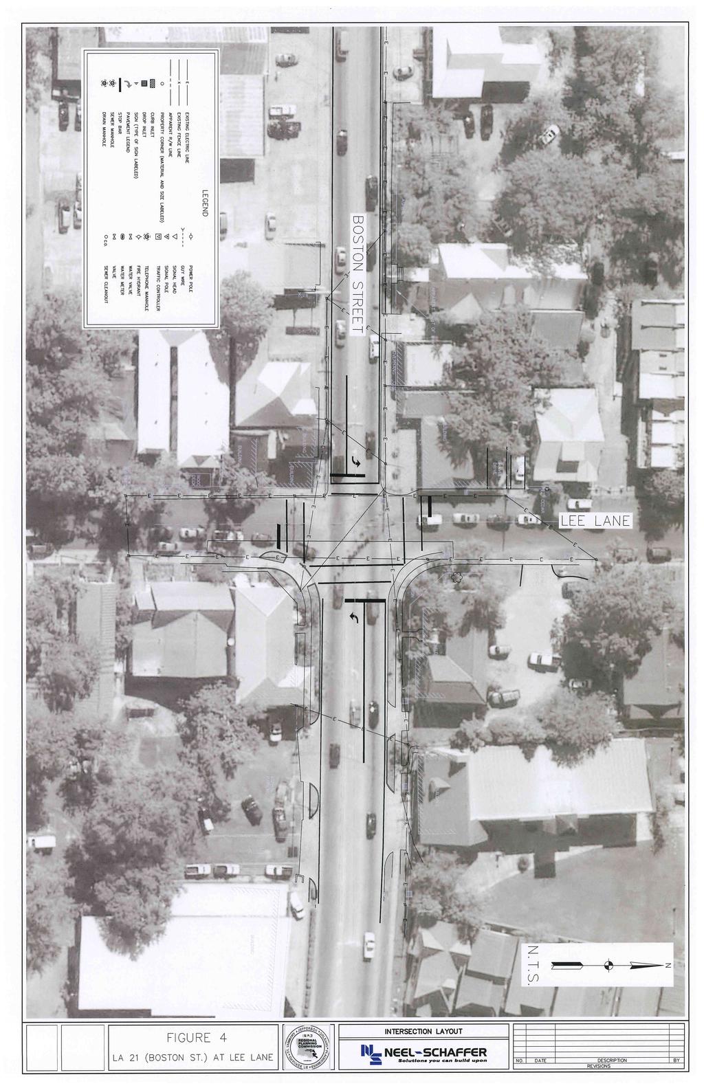
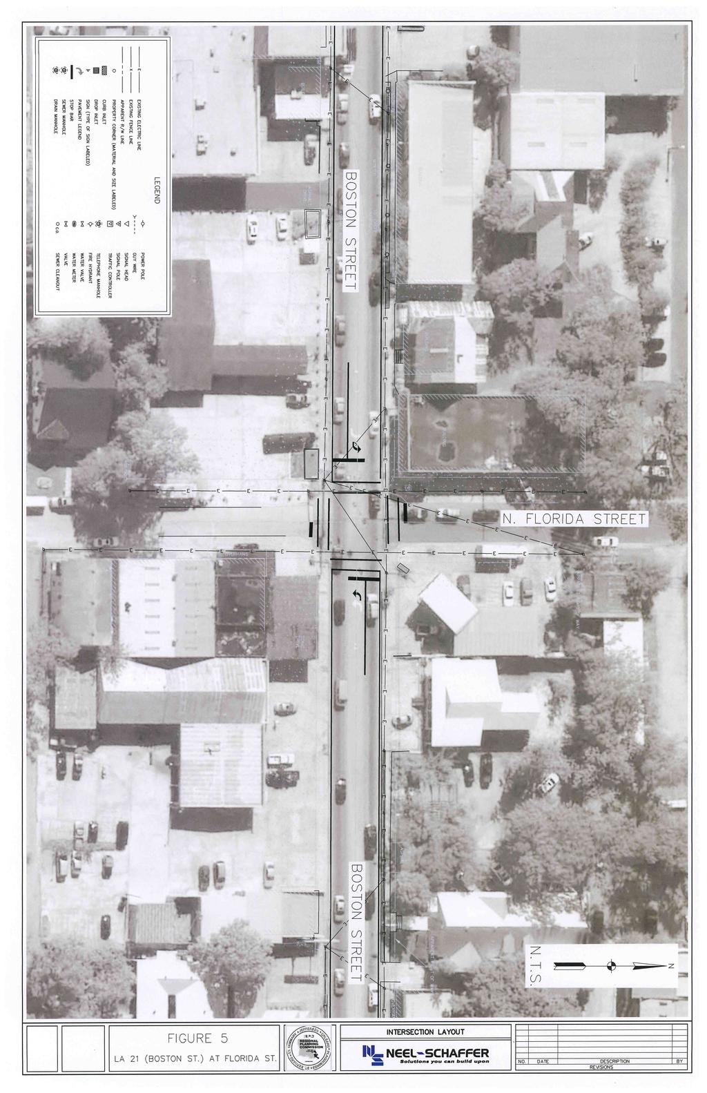
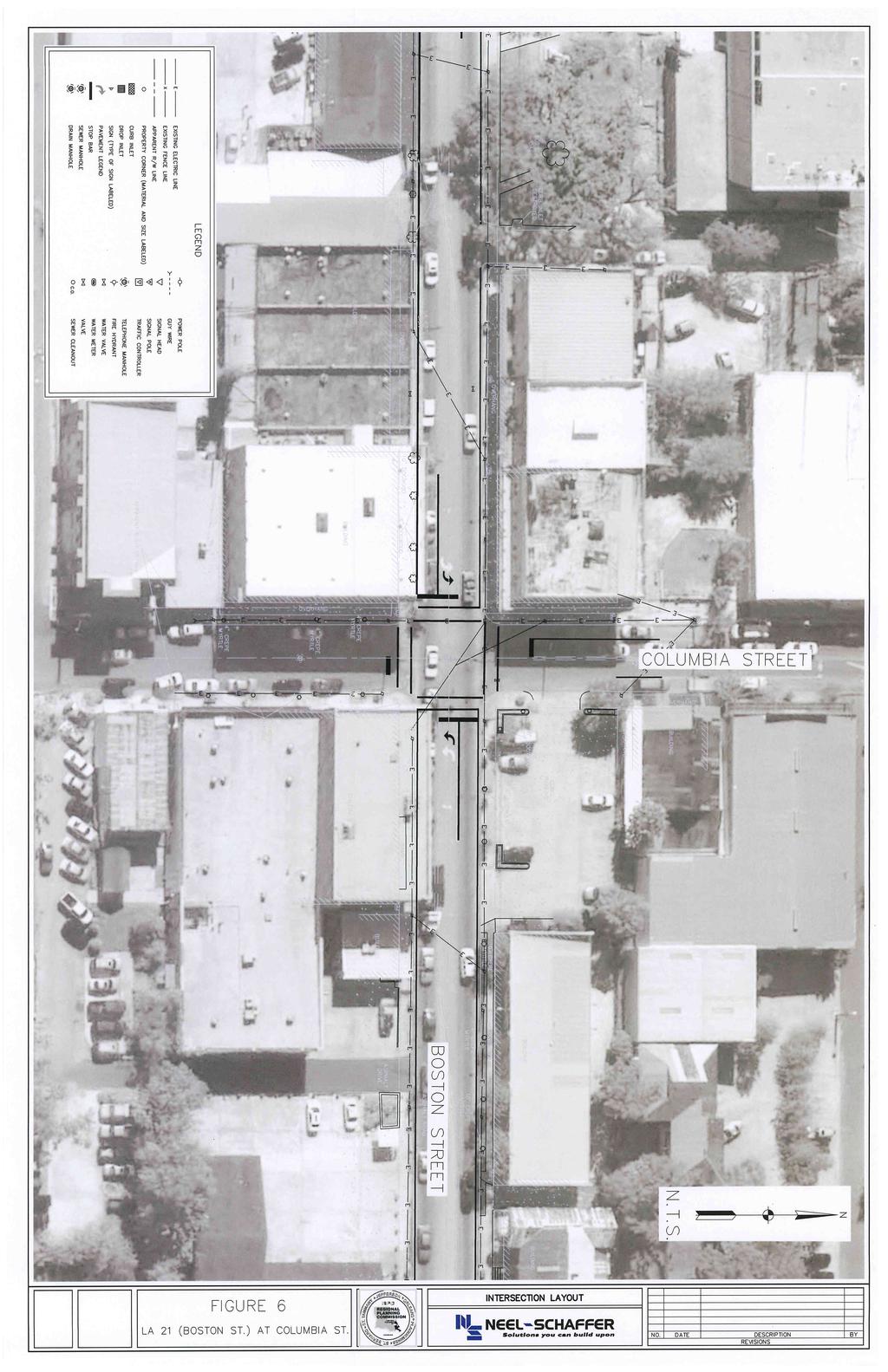
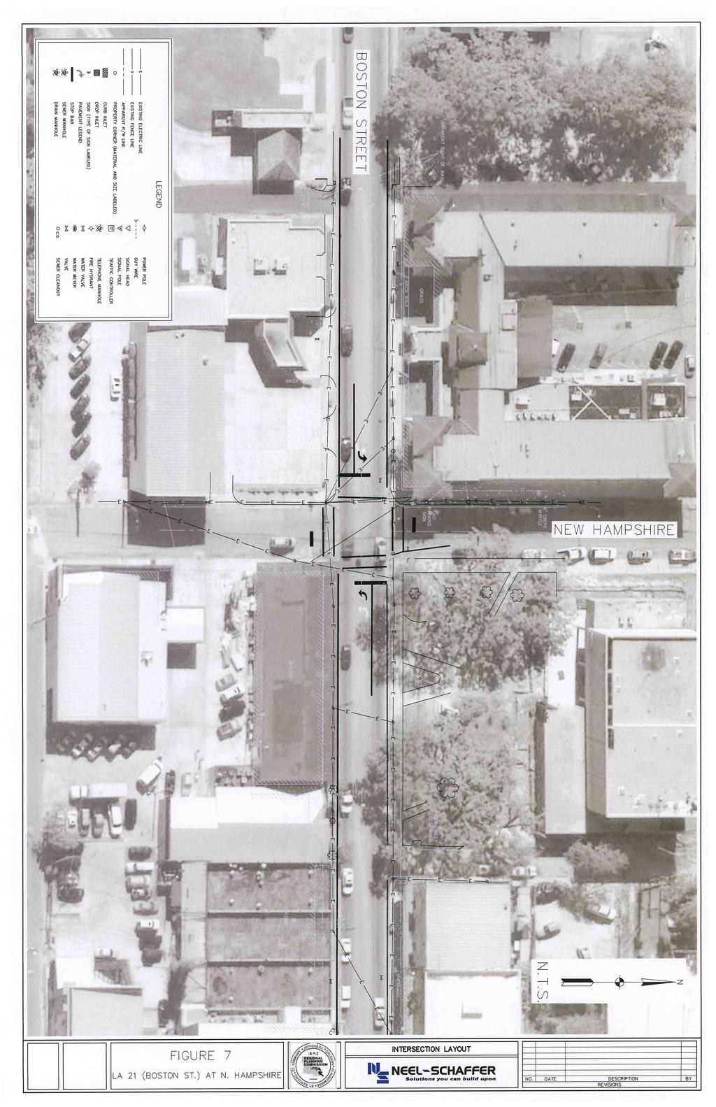
11 Intersection Layouts/Traffic Signal Information The intersection of LA 21 (Boston Street) at Lee Lane is a four legged intersection controlled by a semi-actuated traffic signal with vehicle detection on the side street and the eastbound left turn lane. The signal layout consists of a diagonal span with a ground mounted controller cabinet. The intersection is coordinated via Time Based coordination. The AM peak cycle length is 90 seconds and the noon and PM peak cycle lengths are 100 seconds. This intersection includes pedestrian pushbuttons and pedestrian signal heads. The signal phasing consists of protected/permitted left turns on LA 21 (Boston Street) and only permitted left turns on Lee Lane. In addition, a right turn overlap phase is provided for the south approach on Lee Lane. The existing Traffic Signal Inventory (TSI) form was obtained from LADOTD, District 62 and is included in the Appendix. Additionally, an intersection layout is shown in Figure 4. The intersection of LA 21 (Boston Street) at Florida Street is a four legged intersection controlled by a fixed time traffic signal. The signal layout consists of a diagonal span with a pole mounted controller cabinet. The intersection is coordinated via Time Based coordination. The AM peak cycle length is 90 seconds and the noon and PM peak cycle lengths are 100 seconds. The signal phasing consists of only permitted left turns on LA 21 (Boston Street) and Florida Street. The existing Traffic Signal Inventory (TSI) form was obtained from LADOTD, District 62 and is included in the Appendix. It should be noted that four (4) existing signal pole foundations are installed on all four quadrants of this intersection but are not currently being utilized. Additionally, an intersection layout is shown in Figure 5. The intersection of LA 21 (Boston Street) at. Columbia Street is a four legged intersection controlled by a fixed time traffic signal. The signal layout consists of a diagonal span with a pole mounted controller cabinet. The intersection is coordinated via Time Based coordination. The AM peak cycle length is 90 seconds and the noon and PM peak cycle lengths are 100 seconds. The signal phasing consists of only permitted left turns on LA 21 (Boston Street) and. Columbia Street. The existing Traffic Signal Inventory (TSI) form was obtained from LADOTD, District 62 and is included in the Appendix. Additionally, an intersection layout is shown in Figure 6. The intersection of LA 21 (Boston Street) at. ew Hampshire Street is a four legged intersection controlled by a semi-actuated traffic signal with vehicle detection on the side street. The signal layout consists of a diagonal span with a pole mounted controller cabinet. The intersection is coordinated via Time Based coordination. The AM peak cycle length is 90 seconds and the noon and PM peak cycle lengths are 100 seconds. The signal phasing consists of only permitted left turns on LA 21 (Boston Street) and. Columbia Street. The existing Traffic Signal Inventory (TSI) form was obtained from LADOTD, District 62 and is included in the Appendix. Additionally, an intersection layout is shown in Figure 7. eel-schaffer, Inc. 5
12
13
14
15
16 Traffic Data xisting 24 hour tube counts and turning movement counts for the intersections within the study area were performed by eel-schaffer, Inc. The twenty-four (24) hour tube counts and six (6) hours turning movement counts (vehicular and pedestrians) were performed at these intersections on Thursday, October 15, The six (6) hours turning movement counts included three (3) hours during the AM peak period from 6:00 am 9:00 am, four (4) hours during the oon peak period from 11:00 am 3:00 pm and three (3) hours during the PM peak period from 3:00 pm 6:00 pm. These counts are shown in Figures These counts are provided in the Appendix. In addition, twenty-four (24) hour tube counts were performed at two (2) locations on LA 21 (Boston Street), between Vermont Street and ew Hampshire Street, and between Florida Street and Lee Lane are shown in Figure 11. These counts are provided in Appendix. eel-schaffer, Inc. 10
17 Figure 8: xisting AM Peak Hour Volumes Figure 8 : xisting AM Peak Hour Volumes Covington, LA LA 21 Corridor. ew Hampshire. Columbia Florida Lee Street Street Street Lane LA 21 LA Peak Hr: Peak Hr: Peak Hr: Peak Hr: 7:15-8:15 AM 7:30-8:30 AM 7:45-8:45 AM 7:15-8:15 AM KY: Signalized Intersection Pedestrians x eel-schaffer, Inc. 11
18 Figure 9: xisting oon Peak Hour Volumes. Figure 9 : xisting oon Peak Hour Volumes Covington, LA LA 21 Corridor. ew Hampshire. Columbia Florida Lee Street Street Street Lane LA 21 LA Peak Hr: Peak Hr: Peak Hr: Peak Hr: 11:30 AM - 12:30 PM 11:00 AM - 12:00 PM 11:15 AM - 12:15 PM 12:00-1:00 PM KY: Signalized Intersection Pedestrians x eel-schaffer, Inc. 12
19 Figure 10: xisting PM Peak Hour Volumes Figure 10 : xisting PM Peak Hour Volumes Covington, LA LA 21 Corridor. ew Hampshire. Columbia Florida Lee Street Street Street Lane LA 21 LA Peak Hr: Peak Hr: Peak Hr: Peak Hr: 2:30-3:30 PM 2:30-3:30 PM 2:30-3:30 PM 4:30-5:30 PM KY: Signalized Intersection Pedestrians x eel-schaffer, Inc. 13
20 Figure 11: 24 hour counts Figure 11 : 24-Hour Counts Covington, LA LA 21 Corridor 2009 ADT's Lee Lane ew Hampshire Columbia Florida Street Street Street 40% 55% 7,682 8,327 LA 21 LA 21 11,878 6,561 60% 45% Columbia Florida Lee Street Street Lane ew Hampshire Street KY: Signalized Intersection eel-schaffer, Inc. 14
21 Traffic Analysis By using existing peak hour turning movement counts and signal timing information provided by LADOTD District 62, signalized intersection analyses were performed for the intersections on LA 21 (Boston Street) at Lee Lane, at Florida Street, at. Columbia Street and at. ew Hampshire Street. The signalized intersection analysis was performed using the HCM Signalized module of the Synchro Software (Version 7). LA 21 (Boston Street) at Lee Lane The Level of Service (LOS) for this intersection for the AM, oon and PM peaks for existing volumes are presented in Table 1. These analyses are presented in the Appendix. Table 1: Intersection of LA 21 (Boston Street) at Lee Lane Period B B B SB Overall AM Peak B / 10.9 C / 24.1 C / 31.5 F / C / 25.4 oon Peak B / 14.0 B / 17.4 C / 32.4 / 71.8 C / 21.4 PM Peak B / 18.8 C / 31.8 D / 35.9 F / / 61.8 These analyses indicate that this intersection does not operate at an acceptable Level of Service (LOS) during PM peak hour. In addition, the southbound approach fails to operate at an acceptable Level of Service (LOS) during both AM and PM peak hours. LA 21 (Boston Street) at Florida Street The Level of Service (LOS) for this intersection for the AM, oon and PM peaks for existing volumes are presented in Table 2. These analyses are presented in the Appendix. Table 2: Intersection of LA 21 (Boston Street at Florida Street Period B B B SB Overall AM Peak A / 3.5 A / 1.3 D / 35.2 D / 41.7 A / 4.4 oon Peak A / 5.3 A / 4.2 C / 34.7 D / 39.9 A / 7.9 PM Peak A / 5.4 A / 2.3 C / 35.0 D / 36.1 A / 6.1 These analyses indicate that this intersection operates at an acceptable Level of Service (LOS) during AM, oon and PM peak hours. eel-schaffer, Inc. 15
22 LA 21 (Boston Street) at. Columbia Street The Level of Service (LOS) for this intersection for the AM, oon and PM peaks for existing volumes are presented in Table 3. These analyses are presented in the Appendix. Table 3: Intersection of LA 21 (Boston Street at. Columbia Street Period B B B SB Overall AM Peak B / 10.6 A / 6.3 C / 23.6 C / 29.5 B / 10.8 oon Peak B / 15.9 A / 8.0 C / 24.3 C / 30.3 B / 14.6 PM Peak B / 15.2 A / 8.8 C / 24.8 C / 29.1 B / 14.2 These analyses indicate that this intersection operates at an acceptable Level of Service (LOS) during AM, oon and PM peak hours. LA 21 (Boston Street) at ew Hampshire Street The Level of Service (LOS) for this intersection for the AM, oon and PM peaks for existing volumes are presented in Table 4. These analyses are presented in the Appendix. Table 4: Intersection of LA 21 (Boston Street at. ew Hampshire Street Period B B B SB Overall AM Peak A / 3.7 A / 1.0 D / 41.1 D / 42.0 A / 6.8 oon Peak A / 3.9 A / 0.9 D / 46.0 / 55.0 A / 9.1 PM Peak A / 3.7 A / 0.9 D / 44.6 D / 49.2 A / 7.2 These analyses indicate that this intersection operates at an acceptable Level of Service (LOS) during AM, oon and PM peak hours. eel-schaffer, Inc. 16
23 III Conceptual Plan / Recommendations eel-schaffer, Inc has collected traffic data and existing conditions along the corridor LA 21 (Boston Street) in the study area. Based on the existing analyses, recommendations along the corridor were determined. These proposed recommendations are likely to improve pedestrian and vehicular safety and also enhance the vehicle flow along the corridor. The proposed recommendations emphasize upgrading the study area intersections with new signal timing and coordination, crosswalks and decorative mast arms. Additionally, new handicap ramps and sidewalks are proposed in areas where the existing handicap ramps and sidewalks are impacted by the installation of the proposed signal equipment. xisting handicap ramps and sidewalks not impacted by the installation of the proposed signal equipment are not proposed to be replaced under this project. The design plans for the decorative mast arm poles are being developed by Union Metal Corporation. A copy of the proposed decorative mast arm pole design is provided in the Appendix. Additionally, due to potential conflicts with numerous utilities within the corridor, it was determined that all conduit that is typically directionally drilled on these type projects should be installed by saw cutting the existing roadway, trenching and installing conduit. However, due to an overlay project currently scheduled for construction, it was determined to have the conduit required beneath roadways be installed as part of the overlay project. SI personnel work with LADOTD District 62 personnel to develop quantities and details for this work to be included in the overlay project. The information provided to LADOTD is provided in the Appendix. Intersection specific proposed recommendations are provided as follows. Traffic Signal quipment Upgrades LA 21 (Boston Street) at Lee Lane The intersection of LA 21 (Boston Street) at Lee Lane is recommended to be upgraded with a new dual mast arm signal pole on the southeast quadrant and new single mast arm signal poles on the northeast and northwest quadrants of the intersection. A new ground mounted Type 6 cabinet with GPS and a TS-2 controller is proposed to be located in the southeast quadrant. The GPS will allow these intersections to be Time Based coordinated. Video detection is recommended to be installed for the northbound and the southbound approaches on Lee Lane and also for the left turn lanes on LA 21 (Boston Street). In addition, pedestrian crossings are proposed along all four (4) approaches including new crosswalks along all the four (4) approaches with pedestrian signal heads and push buttons on the four (4) corners of the intersection. Handicap ramps are also proposed in the following quadrants of this intersection to replace existing handicap ramps and sidewalk impacted by the installation of the proposed signal equipment. eel-schaffer, Inc. 17
24 One (1) handicap ramp in the southwest quadrant Two (2) handicap ramps in the northwest quadrant The proposed signal upgrade design plans with these proposed recommendations are provided in the Appendix. LA 21 (Boston Street) at Florida Street The intersection of LA 21 (Boston Street) at Florida Street is recommended to be upgraded with new single mast arm signal poles on all the four (4) quadrants of the intersection. Based on the Plan In Hand (PIH) visit, it was noted that four (4) existing unused signal pole foundations are located at this intersection. It was determined all parties present at the PIH that these existing signal pole foundations should be utilized for the installation of these new signal mast arm poles versus installing new foundations due to the potential conflicts with numerous utilities. A new ground mounted Type 6 cabinet with GPS and a TS-2 controller is proposed to be located in the southwest quadrant. The GPS will allow these intersections to be Time Based coordinated. The existing signal phasing consisting of only permitted left turns on LA 21 (Boston Street) is proposed to be modified to protected/permitted left turn phasing. Video detection is recommended to be installed for the northbound and the southbound approaches on Florida Street and also for the left turn lanes on LA 21 (Boston Street). In addition, new pedestrian cross walks are proposed along all four (4) approaches of the intersections. However, no pedestrian signal heads or push buttons are being considered at this intersection at the request of LADOTD personnel present at the PIH. Although no pedestrian signals or push buttons are being proposed, the placement of the vehicular signal heads and minimum signal timing for the side street movements was calculated to assure that pedestrians would have sufficient time to cross LA 21 (Boston Street). Handicap ramps are also proposed in the following quadrants of this intersection to replace existing handicap ramps and sidewalk impacted by the installation of the proposed signal equipment. One (1) handicap ramp in the southwest quadrant Two (2) handicap ramps in the northwest quadrant One (1) handicap ramp in the southeast quadrant One (1) handicap ramp in the northeast quadrant The proposed signal upgrade design plans with these proposed recommendations are provided in the Appendix. LA 21 (Boston Street) at. Columbia Street The intersection of LA 21 (Boston Street) at. Columbia Street is recommended to be upgraded with new dual mast arm signal poles on the southeast and northwest quadrants of the intersection. eel-schaffer, Inc. 18
25 A new pole mounted Type 3 cabinet with GPS and a TS-2 controller is proposed to be pole mounted on the proposed dual mast arm signal pole located in the southeast quadrant. The GPS will allow these intersections to be Time Based coordinated. The existing signal phasing consisting of only permitted left turns on LA 21 (Boston Street) is proposed to be modified to protected/permitted left turn phasing. Video detection is recommended to be installed for the northbound and the southbound approaches on. Columbia Street and also for the left turn lanes on LA 21 (Boston Street). In addition, new pedestrian cross walks are proposed along all four (4) approaches of the intersections. However, no pedestrian signal heads or push buttons are being considered at this intersection at the request of LADOTD personnel present at the PIH. Although no pedestrian signals or push buttons are being proposed, the placement of the vehicular signal heads and minimum signal timing for the side street movements was calculated to assure that pedestrians would have sufficient time to cross LA 21 (Boston Street). Handicap ramps are also proposed in the following quadrants of this intersection to replace existing handicap ramps and sidewalk impacted by the installation of proposed the signal equipment. One (1) handicap ramp in the northeast quadrant Two (2) handicap ramps in the southeast quadrant The proposed signal upgrade design plans with these proposed recommendations are provided in the Appendix. LA 21 (Boston Street) at. ew Hampshire Street The intersection of LA 21 (Boston Street) at. ew Hampshire Street is recommended to be upgraded with new dual mast arm signal poles on southeast and northwest quadrants of the intersection. It is recommended that these new dual mast arm signal poles be installed on existing signal pole foundations due to limited right of way and potential conflicts with numerous utilities. This will require for the existing signal poles to be removed prior to the installation of the new dual mast arm poles. This may require this intersection to be controlled temporarily with a four-way stop during construction until the new dual mast arm poles are installed and operational. A new pole mounted Type 3 cabinet with GPS and a TS-2 controller is proposed to be pole mounted on the proposed dual mast arm signal pole located in the southeast quadrant. The GPS will allow these intersections to be Time Based coordinated. The existing signal phasing consisting of only permitted left turns on LA 21 (Boston Street) is proposed to be modified to protected/permitted left turn phasing. Video detection is recommended to be installed for the northbound and the southbound approaches on. ew Hampshire Street and also for the left turn lanes on LA 21 (Boston Street). In addition, new pedestrian cross walks are proposed along all four (4) approaches of the eel-schaffer, Inc. 19
26 intersections. However, no pedestrian signal heads or push buttons are being considered at this intersection at the request of LADOTD personnel present at the PIH. Although no pedestrian signals or push buttons are being proposed, the placement of the vehicular signal heads and minimum signal timing for the side street movements was calculated to assure that pedestrians would have sufficient time to cross LA 21 (Boston Street). Handicap ramps are also proposed in the following quadrants of this intersection to replace existing handicap ramps and sidewalk impacted by the installation of proposed the signal equipment. Two (2) handicap ramp in the northwest quadrant Two (2) handicap ramps in the southwest quadrant The proposed signal upgrade design plans with these proposed recommendations are provided in the Appendix. eel-schaffer, Inc. 20
27 Coordinated Traffic Signal Timing Plan Analysis By using existing peak hour volumes and the proposed signal upgrade recommendations, the signalized intersection analyses were performed for the study area intersections on LA 21 (Boston Street). Recommended signal timing and coordination plans were developed at these intersections, using Synchro Software (Version 7), to optimize the traffic flow on the corridor. It should be noted that the intersection of LA 21 (Boston Street) at Lee Lane was considered the master location. The new cycle lengths and offsets developed for the peak periods are shown in the Table 5. Table 5: Intersection Cycle Lengths and Offsets Intersection of LA 21 (Boston Street) at AM Peak Cycle Length / Offset (sec) oon Peak Cycle Length / Offset (sec) PM Peak Cycle Length / Offset (sec) Lee Lane 90.0 / / / 0.0 Florida Street 90.0 / / / 2.0 Columbia Street 90.0 / / / 99.0 ew Hampshire Street 90.0 / / / 8.0 Using the proposed timing information, the signalized intersection analysis was performed using the HCM Signalized module of the Synchro Software (Version 7). It should be noted that the methodology for the development of the coordination plans was to limit the amount of green time assigned to the side streets while maximizing the amount of green time on LA 21 (Boston Street) and providing protected left turn phases on LA 21 (Boston Street). Additionally, proposed clearance intervals were determined based on the proposed stop bar locations shown on the proposed signal upgrade design plans. These clearance interval calculations are presented in the Appendix. LA 21 (Boston Street) at Lee Lane The Level of Service (LOS) for this intersection during the AM, oon and PM peaks for the proposed recommended signal timing with existing volumes are presented in Table 6. These analyses are presented in the Appendix. Table 6: Intersection of LA 21 (Boston Street) at Lee Lane - Recommended Period B B B SB Overall AM Peak B / 19.3 C / 26.3 C / 31.1 F / C / 27.7 oon Peak B / 13.7 B / 14.2 D / 36.4 F / C / 27.9 PM Peak D / 37.5 D / 48.1 C / 33.3 F / D / 53.9 eel-schaffer, Inc. 21
28 The analyses indicate that the overall intersection operates at an acceptable LOS during AM, oon and PM peak hours. However, the southbound approach fails to operate at an acceptable Level of Service (LOS) during the peak hours. LA 21 (Boston Street) at Florida Street The Level of Service (LOS) for this intersection during the AM, oon and PM peaks for the proposed recommended signal timing with existing volumes are presented in Table 7. These analyses are presented in the Appendix. Table 7: Intersection of LA 21 (Boston Street) at Florida Street - Recommended Period B B B SB Overall AM Peak A / 5.2 A / 1.3 D / 38.4 D / 46.3 A / 5.4 oon Peak A / 6.1 A / 2.5 D / 41.3 D / 53.8 A / 8.6 PM Peak A / 4.3 A / 1.7 D / 45.5 D / 47.0 A / 6.1 The analyses indicate that the overall intersection operates at an acceptable Level of Service (LOS) during AM, oon and PM peak hours. LA 21 (Boston Street) at. Columbia Street The Level of Service (LOS) for this intersection during the AM, oon and PM peaks for the proposed recommended signal timing with existing volumes are presented in Table 8. These analyses are presented in the Appendix. Table 8: Intersection of LA 21 (Boston Street) at. Columbia Street - Recommended Period B B B SB Overall AM Peak A / 6.1 A / 8.4 C / 31.1 D / 43.7 B / 11.9 oon Peak A / 8.2 A / 7.5 C / 34.3 D / 48.0 B / 13.8 PM Peak A / 7.7 A / 7.4 D / 35.5 D / 46.0 B / 13.0 The analyses indicate that the overall intersection operates at an acceptable Level of Service (LOS) during AM, oon and PM peak hours. LA 21 (Boston Street) at. ew Hampshire Street The Level of Service (LOS) for this intersection during the AM, oon and PM peaks for the proposed recommendations and signal timing with existing volumes are presented in Table 9. These analyses are presented in the Appendix. eel-schaffer, Inc. 22
29 Table 9: Intersection of LA 21 (Boston Street) at. ew Hampshire Street - Recommended Period B B B SB Overall AM Peak A / 7.3 A / 2.4 D / 41.1 D / 42.0 A / 8.9 oon Peak A / 8.0 A / 2.0 D / 45.0 D / 51.9 B / 11.1 PM Peak A / 7.5 A / 1.5 D / 44.6 D / 49.2 A / 9.1 The analyses indicate that the overall intersection operates at an acceptable Level of Service (LOS) during AM, oon and PM peak hours. stimated Opinion of Probable Construction Cost Based on the estimated quantities required to upgrade these four signalized intersections on LA 21 (Boston Street), the estimated opinion of probable cost is $666, This opinion of probable cost is based on recent unit prices for the proposed estimated quantities. A summary of the estimated quantities and estimated opinion of probable cost are show in Table 10. A detail estimate opinion of probable cost is show in the Appendix. eel-schaffer, Inc. 23
30 Table 10: stimated Quantities and stimated Opinion of Probable Construction Cost Description Unit of Measure Total s Unit Cost Removal of Concrete alks and Drives Square Yard 180 $60.00 $10, Removal of Signal quipment Lump Sum Lump $10, $10, Concrete alk (6" Thick) Square Yard 104 $ $13, Incidental Concrete Paving (6" Thick) Square Yard 43 $ $10, Handicapped Curb Ramps ach 15 $3, $48, Temporary Signs and Barricades Lump Sum Lump $15, $15, Mobilization Lump Sum Lump $10, $10, Sign (Type A) Square Foot 46.0 $60.00 $2, Plastic Pavement Striping (6" idth) (Thermoplastic 125 mil) Linear Foot 1200 $1.15 $1, Plastic Pavement Striping (24" idth) (Thermoplastic 125 mil) Linear Foot 290 $4.00 $1, Trenching and Backfilling Linear Foot 400 $4.00 $1, Jacked or Bored Conduit (2 HDP, Schedule 80) Linear Foot 65 $10.00 $ Jacked or Bored Conduit (3 HDP, Schedule 80) Linear Foot 195 $12.00 $2, Signal Support (20' Single Mast Arm) ach 2 $17, $35, Signal Support (25' Single Mast Arm) ach 1 $18, $18, Signal Support (30' Single Mast Arm) ach 2 $18, $37, Signal Support (35' Single Mast Arm) ach 4 $19, $79, Signal Support (40' Single Mast Arm) ach 2 $20, $41, Signal Support (Clamp on 30' Arm) ach 4 $8, $32, Signal Support (Clamp on 45' Arm) ach 1 $9, $9, Signal Heads (3 Section, 12" Led Lens, R, Y, G) ach 32 $1, $38, Signal Heads (5 Section, 12" Led Lens, R, Y, LT.Y, G, LT.G) ach 8 $1, $15, Signal Service (xisting Pole) ach 4 $1, $4, Signal Controller (TS-2, Type 2; Type 3 Cabinet) ach 2 $15, $30, Signal Controller (TS-2, Type 2; Type 6 Cabinet) ach 2 $22, $44, Underground Junction Box (Type F) ach 16 $ $11, Underground Junction Box (Type H) ach 4 $1, $4, Conduit (2" HDP, Schedule 80) Linear Foot 170 $4.00 $ Conduit (3" HDP, Schedule 80) Linear Foot 230 $5.75 $1, Conductor (2c, Loop Lead in, IMSA 50-2, #14 awg, Twisted Pair) Linear Foot 605 $1.00 $ Conductor (3c, 6 gauge/#6 awg) Linear Foot 250 $4.00 $1, Conductor (6c, #14 awg) Linear Foot 605 $2.00 $1, Conductor (10c, #14 awg) Linear Foot 1365 $2.90 $3, Video Detector (MVP) Device ach 16 $6, $100, Video Detector System ach 4 $4, $16, GPS ach 4 $1, $6, LD Pedestrian Signal Head ach 8 $ $4, Pedestrian Pushbuttons ach 8 $90.00 $ stimated Opinion of Probable Construction Cost = $666, Cost eel-schaffer, Inc. 24
31 APPDIX eel-schaffer, Inc. 25
JEP John E. Jack Pflum, P.E. Consulting Engineering 7541 Hosbrook Road, Cincinnati, OH Telephone:
 JEP John E. Jack Pflum, P.E. Consulting Engineering 7541 Hosbrook Road, Cincinnati, OH 45243 Email: jackpflum1@gmail.com Telephone: 513.919.7814 MEMORANDUM REPORT Traffic Impact Analysis Proposed Soccer
Franklin County Engineer's Office - Highway Design Dublin Road And Fishinger Road Improvements Rebid Bid Tabulation
 2/20/2015 Page 1 of 16 Strawser Paving Co., Inc. Double Z Construction Co Decker Construction Company Shelly & Sands, Inc. 1595 Frank Road 2550 Harrison Road 3040 McKinley Avenue P.O.Box 2469 Columbus,
WEBER ROAD RESIDENTIAL DEVELOPMENT Single Family Residential Project
 WEBER ROAD RESIDENTIAL DEVELOPMENT Single Family Residential Project WEBER ROAD RESIDENTIAL DEVELOPMENT TRAFFIC IMPACT STUDY TABLE OF CONTENTS 1.0 Executive Summary Page 2.0 Introduction 2.1 DEVELOPMENT
NATHAN HALE HIGH SCHOOL PARKING AND TRAFFIC ANALYSIS. Table of Contents
 Parking and Traffic Analysis Seattle, WA Prepared for: URS Corporation 1501 4th Avenue, Suite 1400 Seattle, WA 98101-1616 Prepared by: Mirai Transportation Planning & Engineering 11410 NE 122nd Way, Suite
CVS Derwood. Local Area Transportation Review
 CVS Derwood Montgomery County, Maryland May 27, 2016 Local Area Transportation Review Prepared for: JC Bar Properties, Inc. Steve Fleming, PE 415 Fallowfield Road, Suite 301 Camp Hill, Pennsylvania 17011
HALFF 16196? TRAFFIC MANAGEMENT PLAN. Richardson ISD Aikin Elementary School Dallas, Texas North Bowser Road Richardson, Texas 75081
 30280 16196? TRAFFIC MANAGEMENT PLAN Exhibit 572B Aikin Elementary School Planned Development District No. 572 Approved City Plan Commission October20, 2016 July 12, 2016 Prepared for HALFF AVO 31586 PHO1
SHORT NIGHTTIME WATER SHUTDOWN TO OCCUR IN EARLY HOURS OF MAY 29
 Thank you for your interest in the Center City Connector Streetcar. In this weekly update, you ll find information about ongoing construction for the 1st phase of utility work in Pioneer Square. UPDATES
Market Street PDP. Nassau County, Florida. Transportation Impact Analysis. VHB/Vanasse Hangen Brustlin, Inc. Nassau County Growth Management
 Transportation Impact Analysis Market Street PDP Nassau County, Florida Submitted to Nassau County Growth Management Prepared for TerraPointe Services, Inc. Prepared by VHB/Vanasse Hangen Brustlin, Inc.
April 10, Mr. Curt Van De Walle, City Manager City of Castle Hills 209 Lemonwood Drive Castle Hills, Texas 78213
 Mr. Curt Van De Walle, City Manager City of Castle Hills 209 Lemonwood Drive Castle Hills, Texas 78213 Subject: Revised Castle Hills BASIS Charter School Traffic Impact Analysis Review City of Castle Hills,
The Highline Development Traffic Impact Study
 The Highline Development Traffic Impact Study Columbia Falls, Montana Prepared For: TD&H Engineering 450 Corporate Drive, Suite 101 Kalispell, MT 59901 June, 2018 130 South Howie Street Helena, Montana
RESOLUTION NO
 RESOLUTION NO. 14-31 A RESOLUTION OF THE CITY COMMISSION OF THE CITY OF TREASURE ISLAND APPROVING THE EXECUTION OF A WORK AUTHORIZATION WITH MICHAEL BAKER JR., INC ENGINEERING TO COMPLETE ENGINEERING AND
MEMORANDUM. The study area of the analysis was discussed with City staff and includes the following intersections:
 MEMORANDUM DATE: JULY 6, 2012 TO: FROM: RE: CC: MELANIE KNIGHT BRAD BYVELDS/ JENNIFER LUONG 1050 SOMERSET STREET PRELIMINARY TRAFFIC ANALYSIS OUR FILE NO. 111152 NEIL MALHOTRA The purpose of this memo
6711 LEE HIGHWAY TRAFFIC IMPACT STUDY ARLINGTON, VIRGINIA
 6711 TRAFFIC IMPACT STUDY ARLINGTON, VIRGINIA Prepared for: NVR, Inc. Prepared by: Wells + Associates, Inc. Michael J. Workosky, PTP, TOPS, TSOS John J. Andrus William L. Zeid, PE 703.917.6620 May 4, 2017
Prepared for. 3D/International, Inc West Loop South, Suite 400 Houston, Texas November 2006
 DRAFT TRAFFIC IMPACT STUDY FOR PHASED DEVELOPMENT OF TAMU CC Prepared for 3D/International, Inc. 1900 West Loop South, Suite 400 Houston, Texas 77027 November 2006 Interim Review Only Document Incomplete:
TRAFFIC IMPACT STUDY. Platte Canyon Villas Arapahoe County, Colorado (Arapahoe County Case Number: Z16-001) For
 For") TRAFFIC IMPACT STUDY For Platte Canyon Villas Arapahoe County, Colorado (Arapahoe County Case Number: Z16-001) February 2015 Revised: August 2015 April 2016 July 2016 September 2016 Prepared for: KB Home
TRAFFIC IMPACT STUDY For Platte Canyon Villas Arapahoe County, Colorado (Arapahoe County Case Number: Z16-001) February 2015 Revised: August 2015 April 2016 July 2016 September 2016 Prepared for: KB Home
Traffic Impact Study
 Traffic Impact Study Statham DRI One University Parkway Prepared for: Barrow County Prepared by: October 2012 Table of Contents Executive Summary i Section 1. Introduction 1 Project Description 1 Methodology
CHAPTER 3. CAPACITY OF SIGNALIZED INTERSECTIONS
 CHAPTER 3. CAPACITY OF SIGNALIZED INTERSECTIONS 1. Overview In this chapter we explore the models on which the HCM capacity analysis method for signalized intersections are based. While the method has
TRANSPORTATION AND TRAFFIC ANALYSIS REPORT
 Square One Drive Extension Municipal Class Environmental Assessment Environmental Study Report Appendix B Transportation and Traffic Analysis Report TRANSPORTATION AND TRAFFIC ANALYSIS REPORT FINAL DRAFT
TRAFFIC IMPACT STUDY MANUFACTURING COMPANY
 TRAFFIC IMPACT STUDY For MANUFACTURING COMPANY Prepared For: Airway Heights, WA Prepared By: SUNBURST ENGINEERING, P. S. 4310 S. Ball Dr. Veradale, WA 99037 April, 2013 TRAFFIC IMP ACT STUDY Manufacturing
Table of Contents Introduction... 4 Study Area... 5
 Table of Contents Introduction... 4 Study Area... 5 Streets and s... 5 Traffic Volumes... 8 Recent and Anticipated Development... 10 Crash Analysis... 10 Projected Traffic Volumes... 11 Trip Generation...
Appendix I: Traffic Study
 City of Fontana Sierra Lakes Commerce Center Draft EIR Appendix I: Traffic Study FirstCarbon Solutions H:\Client (PN JN)\0144\01440050\EIR\1 ADEIR\01440050 Sec99 99 Appendix Dividers.doc THIS PAGE INTENTIONALLY
ROAD SAFETY AUDIT. South Street / Electric Avenue / Old South Street. City of Fitchburg. October 26, Prepared For: MassDOT
 ROAD SAFETY AUDIT / Electric Avenue / Old City of Fitchburg October 26, 2015 Prepared For: MassDOT On Behalf Of: City of Fitchburg Prepared By: TEC, Inc. 65 Glenn Street Lawrence, MA 01843 Road Safety
PW 001 SNOW REMOVAL AND SANDING FOR ROADWAYS AND SIDEWALKS October 6, 2014 (#223-14) Original October 19, 2015; October 15, 2018 Public Works
 Original October 19, 2015; October 15, 2018 Public Works") Policy Statement: The Village of Kitscoty will provide snow and ice control on municipal streets and sidewalks according to determined priorities. Purpose: To provide direction and information to employees
Policy Statement: The Village of Kitscoty will provide snow and ice control on municipal streets and sidewalks according to determined priorities. Purpose: To provide direction and information to employees
FY 2010 Continuing i Planning Program Product Report. Local Transportation and Traffic Data. Wood-Washington-Wirt Interstate Planning Commission
 FY 2010 Continuing i Planning Program Product Report Local Transportation and Traffic Data Travel Time and Delay Data for Belpre and Marietta, Ohio Wood-Washington-Wirt Interstate Planning Commission CONTINUING
12"CMP DIA. ELEV. PVC CI DI CMP VCP RCP RCAP LRCP LCPP STA. LA LB BM-2 ROW PI POT LF TH PVC
 PLANS FOR X-REFS: FILE PATH: Z:\WEST BRANCH 3682 MAIN STREET SIDEWALK IMPROVEMENTS - PHASE 3\DRAWINGS\_PRODUCTION DRAWINGS\TITLE & INDEX PLOTTED: Thursday, May 26, 216 4:7:42 PM MAIN STREET SIDEWALK PHASE
TRAFFIC STUDY FOR THE GAFFEY POOL PROJECT LOS ANGELES, CALIFORNIA CITY OF LOS ANGELES, BUREAU OF ENGINEERING OCTOBER 2013 PREPARED FOR PREPARED BY
 TRAFFIC STUDY FOR THE GAFFEY POOL PROJECT LOS ANGELES, CALIFORNIA OCTOBER 2013 PREPARED FOR CITY OF LOS ANGELES, BUREAU OF ENGINEERING PREPARED BY DRAFT TRAFFIC STUDY FOR THE GAFFEY POOL PROJECT October
Appendixx C Travel Demand Model Development and Forecasting Lubbock Outer Route Study June 2014
 Appendix C Travel Demand Model Development and Forecasting Lubbock Outer Route Study June 2014 CONTENTS List of Figures-... 3 List of Tables... 4 Introduction... 1 Application of the Lubbock Travel Demand
I-95/I-85 INTERCHANGE ROADWAY SAFETY ASSESSMENT
 FINAL REPORT I-95/I-85 INTERCHANGE ROADWAY SAFETY ASSESSMENT Prepared for: Prepared by: 117306012.B MARCH 2013 Final Report March 2013 I-95/I-85 Interchange ROADWAY SAFETY ASSESSMENT Prepared for: Prepared
PLAZA MEXICO RESIDENCES
 PLAZA MEXICO RESIDENCES TRAFFIC STUDY PREPARED FOR: 3000 E. IMPERIAL, LLC. 6940 Beach Boulevard, D-501 Buena Park, California 90621 PREPARED BY: OCTOBER 5, 2017 translutions the transportatio n solutions
KAISER SOUTH NORTHERN VIRGINIA HUB TRAFFIC IMPACT STUDY PRINCE WILLIAM COUNTY, VIRGINIA TABLE OF CONTENTS. Section 2 BACKGROUND INFORMATION 12
 KAISER SOUTH NORTHERN VIRGINIA HUB TRAFFIC IMPACT STUDY PRINCE WILLIAM COUNTY, VIRGINIA TABLE OF CONTENTS Page EXECUTIVE SUMMARY 1 Purpose of Report and Study Objectives... 1 Site Location and Study Area...
Signalized Intersections
 Signalized Intersections Kelly Pitera October 23, 2009 Topics to be Covered Introduction/Definitions D/D/1 Queueing Phasing and Timing Plan Level of Service (LOS) Signal Optimization Conflicting Operational
City of Laramie, Wyoming SNOW AND ICE POLICY
 City of Laramie, Wyoming SNOW AND ICE POLICY 11/02/89; rev 10/15/2007 I. INTRODUCTION The intention of this Policy is to set reasonable goals and general practices as a guide for the conduct of snow and
CITY OF NEW LONDON WINTER ROAD & SIDEWALK MAINTENANCE POLICY
 CITY OF NEW LONDON WINTER ROAD & SIDEWALK MAINTENANCE POLICY GENERAL The purpose of this policy is to set up acceptable procedures and policies for the winter maintenance of public areas in the City of
TRAFFIC IMPACT STUDY
 TRAFFIC IMPACT STUDY TERRE HAUTE CONVENTION CENTER WABASH AVENUE & 9 TH STREET TERRE HAUTE, INDIANA PREPARED FOR 8365 Keystone Crossing, Suite 201 Indianapolis, IN 46240 Phone: (317) 202-0864 Fax: (317)
FINAL Traffic Report for the Proposed Golden Valley Road and Newhall Ranch Road Projects in the City of Santa Clarita, California May 5, 2005
 FINAL Traffic Report for the Proposed Golden Valley Road and Newhall Ranch Road Projects in the City of Santa Clarita, California May 5, 2005 Prepared For: EDAW, Inc. 1420 Kettner Boulevard, Suite 620
Focused Traffic Analysis for the One Lincoln Park Project
 September 15, 2015 Mr. Bill Johnson Coldwell Banker 511 Sir Francis Drake Boulevard Greenbrae, CA 94904 Focused Traffic Analysis for the One Lincoln Park Project Dear Mr. Johnson; As requested, W-Trans
Speed Limit Review. Montague Road, West End. Prepared for Brisbane City Council CEB06842 CEB06842
 Speed Limit Review Montague Road, West End CEB06842 CEB06842 Prepared for Brisbane City Council 2 November 2016 Speed Limit Review Montague Road, West End Document Information Prepared for Brisbane City
SUBJECT: SUMMARY OF FINDINGS. October 29, Mr. Carter Redish Carter Group Architects, Inc S. El Camino Real, Suite F San Clemente, CA 92672
 October 29, 2018 Mr. Carter Redish Carter Group Architects, Inc. 1810 S. El Camino Real, Suite F San Clemente, CA 92672 SUBJECT: CANYON STEEL FOCUSED TRAFFIC IMPACT ANALYSIS Dear Mr. Carter Redish: Urban
MADISON, WI STONE HOUSE DEVELOPMENT 1000 E. WASHINGTON AVENUE REDEVELOPMENT TRANSPORTATION STUDY DECEMBER 14, 2015
 MADISON, WI STONE HOUSE DEVELOPMENT 1000 E. WASHINGTON AVENUE REDEVELOPMENT TRANSPORTATION STUDY DECEMBER 14, 2015 TABLE OF CONTENTS... 3 Proposed Development... 3 Methodology... 3 Phase 1 Development...
Addendum No: 1 THE FOLLOWING IS BEING ISSUED AS ADDENDUM NO. 1 PLEASE REVIEW THE FOLLOWING PAGES. Firm: Address
 CITY OF WACO Purchasing Services Post Office Box 2570 Waco, Texas 76702-2570 254 / 750-6640 Fax: 254 / 750-8063 www.waco-texas.com Date: 11/6/17 RFB No: 2017-066 Commodity: Sidewalk Improvement Plans Closing
Appendix C Traffic Study
 Final Environmental Impact Statement Appendix C Traffic Study Schofield Generating Station Project, Hawaii October 2015 C-1 Final Environmental Impact Statement This page intentionally left blank. Schofield
Travel Demand Management Plan
 Travel Demand Management Plan Tryg s & Apartment Building 8 West Lake Street Minneapolis, MN AUTHORIZED PROPERTY REPRESENTATIVE: By Dated: Mr. Johnny Carlson Trammell Crow Chicago Development, Inc. 5 South
MEMORANDUM (DRAFT) DRAFT
 DRAFT") 117 Commercial St. NE, Suite 310 Salem, OR 97301 503.391.8773 www.dksassociates.com MEMORANDUM (DRAFT) DATE: February 15, 2017 TO: FROM: SUBJECT: Alex Dupey, MIG Scott Mansur, PE, PTOE; Garth Appanaitis,
117 Commercial St. NE, Suite 310 Salem, OR 97301 503.391.8773 www.dksassociates.com MEMORANDUM (DRAFT) DATE: February 15, 2017 TO: FROM: SUBJECT: Alex Dupey, MIG Scott Mansur, PE, PTOE; Garth Appanaitis,
CONTINUING PLANNING PROGRAM LOCAL TRANSPORTATION AND TRAFFIC DATA PRODUCT REPORT [OH Corridors]
![CONTINUING PLANNING PROGRAM LOCAL TRANSPORTATION AND TRAFFIC DATA PRODUCT REPORT [OH Corridors]](/thumbs/94/120123757.jpg "CONTINUING PLANNING PROGRAM LOCAL TRANSPORTATION AND TRAFFIC DATA PRODUCT REPORT [OH Corridors]") CONTINUING PLANNING PROGRAM LOCAL TRANSPORTATION AND TRAFFIC DATA PRODUCT REPORT [OH Corridors] Travel Time and Delay Analysis for Belpre (OH) and Marietta (OH) Fiscal Year 2009 Report WOOD WASHINGTON
CONTINUING PLANNING PROGRAM LOCAL TRANSPORTATION AND TRAFFIC DATA PRODUCT REPORT [OH Corridors] Travel Time and Delay Analysis for Belpre (OH) and Marietta (OH) Fiscal Year 2009 Report WOOD WASHINGTON
ROAD SAFETY AUDIT. VFW Parkway at Spring Street at Bridge Street (Route 109) City of Boston. November 13, Prepared For: MassDOT Highway Division
 City of Boston. November 13, Prepared For: MassDOT Highway Division") ROAD SAFETY AUDIT VFW Parkway at Spring Street at Bridge Street (Route 109) City of Boston November 13, 2015 Prepared For: MassDOT Highway Division Prepared By: Nitsch Engineering 2 Center Plaza, Suite
ROAD SAFETY AUDIT VFW Parkway at Spring Street at Bridge Street (Route 109) City of Boston November 13, 2015 Prepared For: MassDOT Highway Division Prepared By: Nitsch Engineering 2 Center Plaza, Suite
1.0 INTRODUCTION AND SUMMARY...
 TABLE OF CONTENTS 1.0 INTRODUCTION AND SUMMARY... 1 1.1 Purpose and Study Objective... 1 1.2 Executive Summary... 1 2.0 ROADWAY CONDITIONS... 5 2.1 Granville Parkway (South Intersection)... 8 2.2 Tuscany
City of Saginaw Right of Way Division Snow and Ice Removal Policy January 18, 2016
 Snow and Ice Removal Policy January 18, 2016 It is the policy of the to provide snowplowing and ice removal services in order to: Provide safe traveling conditions for motorists and pedestrians Assist
VIRGINIA S I-77 VARIABLE SPEED LIMIT SYSTEM FOR LOW VISIBILITY CONDITIONS
 VIRGINIA S I-77 VARIABLE SPEED LIMIT SYSTEM FOR LOW VISIBILITY CONDITIONS Christopher D. McDonald, PE, PTOE Regional Operations Director, Southwest Region NRITS and ITS Arizona Annual Conference October
ADAPTIVE SIGNAL CONTROL IV
 ADAPTIVE SIGNAL CONTROL IV Evaluation of the Adaptive Traffic Control System in Park City, Utah Dr. Peter T. Martin Associate Professor Aleksandar Stevanovic Research Associate Ivana Vladisavljevic Research
A Study of Red Light Cameras in Kansas City, MO
 A Study of Red Light s in Kansas City, MO Prepared by the Special Operations Division Executive Summary This paper will analyze the crash data for the 29 red light cameras located in 17 intersections in
Metro Emergency Security Operations Center (ESOC) 410 Center Street City of Los Angeles
 410 Center Street City of Los Angeles") Metro Emergency Security Operations Center (ESOC) 410 Center Street City of Los Angeles Traffic Study August 31, 2015 AECOM 515 South Flower Street, 4 th Floor Los Angeles, CA 90071 Job Number: 60323255
Metro Emergency Security Operations Center (ESOC) 410 Center Street City of Los Angeles Traffic Study August 31, 2015 AECOM 515 South Flower Street, 4 th Floor Los Angeles, CA 90071 Job Number: 60323255
New Jersey Department of Transportation DATE : 04/10/12 PAGE : TABULATION OF BIDS
 PAGE : 421-1 CONTRACT TIME : 12/15/12 COMPLETION DATE CONTRACT DESCRIPTION : PROJECT(S) : 100% STATE MAINTENANCE ROADWAY REPAIR CONTRACT CENTRAL, CONTRACT NO. C204, DP 11421 ROUTES US 1 NB & SB, 18 NB
SNOW REMOVAL - REQUEST FOR PROPOSAL. Snow Removal/Clearing and Sanding/Salting for Winter Fundy Ocean Research Center for Energy
 Fundy Ocean Research Center for Energy SNOW REMOVAL - REQUEST FOR PROPOSAL Snow Removal/Clearing and Sanding/Salting for Winter 2016-17 Sites 1. FORCE Sub-Station Driveway (portion of Old Black Rock Road),
Appendix B.1 EMME Model Calibration Memo
 Appendix B.1 EMME Model Calibration Memo itrans 144 Front Street West, Suite 655 Toronto, ON M5J 2L7 Tel: (416) 847-0005 Fax: (905) 882-1557 www.hdrinc.com www.itransconsulting.com File: 2.0 Memorandum
CITY OF MINOT SNOW REMOVAL PLAN October 2018
 CITY OF MINOT SNOW REMOVAL PLAN October 2018 1.0 GENERAL This plan has been written to provide information regarding snow removal procedures and policies. The plan provides guidance, while maintaining
City of Camrose Winter Road Maintenance Policy
 City of Camrose Winter Road Maintenance Policy The purpose of this policy is to outline the level of service that the City of Camrose delivers regarding the maintenance of roads in winter conditions. 1.
DOLLAR GENERAL PROJECT FOCUSED TRAFFIC ANALYSIS (REVISED) May 20, 2015
 May 20, 2015") DOLLAR GENERAL PROJECT FOCUSED TRAFFIC ANALYSIS (REVISED) May 20, 2015 May 20, 2015 Mr. Dan Biswas, VP of Development CJS DEVELOPMENT II, LLC 5111 North Scottsdale Road, Suite 200 Scottsdale, CA 85250
DOLLAR GENERAL PROJECT FOCUSED TRAFFIC ANALYSIS (REVISED) May 20, 2015 May 20, 2015 Mr. Dan Biswas, VP of Development CJS DEVELOPMENT II, LLC 5111 North Scottsdale Road, Suite 200 Scottsdale, CA 85250
Bruce Freeman Rail Trail
 Functional Design Report Bruce Freeman Rail Trail Station Road to Concord Town Line Sudbury, Massachusetts PREPARED FOR Town of Sudbury Planning and Community Development 287 Old Sudbury Road Sudbury,
WHITE POINT LANDSLIDE GEOTECHNICAL INVESTIGATION November 29, 2012 Status Report
 Gary Lee Moore, P.E., City Engineer Vince Jones, P.E., Deputy City Engineer WHITE POINT LANDSLIDE GEOTECHNICAL INVESTIGATION November 29, 2012 Status Report White Point Landslide Geotechnical Investigation
2015 Grand Forks East Grand Forks TDM
 GRAND FORKS EAST GRAND FORKS 2015 TRAVEL DEMAND MODEL UPDATE DRAFT REPORT To the Grand Forks East Grand Forks MPO October 2017 Diomo Motuba, PhD & Muhammad Asif Khan (PhD Candidate) Advanced Traffic Analysis
Brandywine Road Speed Study FINAL REPORT
 Brandywine Road Speed Study FINAL REPORT City of Albuquerque Brandywine Road Speed Study Final Report Albuquerque, New Mexico City of Albuquerque May, 2016 Brandywine Road Speed Study Final Report City
20217 CLEAR STONE TON $14.20 $5, $ $ $ %
 ACCOUNT NO: 10332-84-174-84300: 54250(91223) ACCOUNT NO: 10529-403-172: 54440 (91226) ACCOUNT NO: 10463-51-130: 54250 (91223) ACCOUNT NO: 10332-84-174-84300: 54250 (91223) 20217 CLEAR STONE 375.00 TON
Snow and Ice Removal
 Policy # 6.6 Procedure # - Replaces 5.10 & 5.10A Revises - Date Approved February 10, 2014 Method of Approval Resolution #17 1. PRINCIPLES The City of Dauphin desires to maintain the City streets, lanes,
A L A BA M A L A W R E V IE W
 A L A BA M A L A W R E V IE W Volume 52 Fall 2000 Number 1 B E F O R E D I S A B I L I T Y C I V I L R I G HT S : C I V I L W A R P E N S I O N S A N D TH E P O L I T I C S O F D I S A B I L I T Y I N
CE351 Transportation Systems: Planning and Design
 CE351 Transportation Systems: Planning and Design TOPIC: Level of Service (LOS) at Traffic Signals 1 Course Outline Introduction to Transportation Highway Users and their Performance Geometric Design Pavement
Municipal Act, 2001 Loi de 2001 sur les municipalités
 Municipal Act, 2001 Loi de 2001 sur les municipalités ONTARIO REGULATION 239/02 MINIMUM MAINTENANCE STANDARDS FOR MUNICIPAL HIGHWAYS Consolidation Period: From January 25, 2013 to the e-laws currency date.
Critchfield Rd / SR-129
 NOVEMBER 27, 2017 Critchfield Rd / SR-129 Intersection Safety Study Alternatives Report CRITCHFIELD INTERSECTION SAFETY STUDY Contents Introduction...1 Purpose...2 Existing Conditions...2 Proposed Alternatives...2
Town of Bowden Province of Alberta Policy Document ( ) SNOW REMOVAL POLICY
 SNOW REMOVAL POLICY") Town of Bowden Box 338, 2101 20 th Ave Bowden, Alberta, T0M 0K0 Town of Bowden Province of Alberta Policy Document (2019-01) SNOW REMOVAL POLICY 1 INTRODUCTION The purpose of this policy is to establish
Town of Bowden Box 338, 2101 20 th Ave Bowden, Alberta, T0M 0K0 Town of Bowden Province of Alberta Policy Document (2019-01) SNOW REMOVAL POLICY 1 INTRODUCTION The purpose of this policy is to establish
I-10 East at Redd closes for 24 hours this Sunday, Feb 11. Then, I-10 West at Resler closes for 27 hours on Feb 25
 NEWS RELEASE a TxDOT Project For immediate release EL PASO DISTRICT Jennifer Wright (915) 790-4340 Jennifer.Wright3@txdot.gov February 9, 2018 I-10 East at Redd closes for 24 hours this Sunday, Feb 11
FIG. A1 TODDY THOMAS SCHOOL - NORTH SAFE ROUTES TO SCHOOL CONCEPTUAL LAYOUT CITY OF FORTUNA TODDY THOMAS SCHOOL - NORTH GENERAL NOTES KEYNOTES
 GENERAL NOTES. NEW & RELOCATED ROADWAY SIGNS NOT SHOWN FOR CLARITY BUT, ARE INCLUDING IN CONCEPTUAL DESIGN COST ESTIMATE. KEYNOTES E X I S T I N G D E V E L O P M E N T. NEW 5' WIDE CONCRETE SIDEWALK.
The Urbana Free Library Parking and Transportation Study
 CHAMPAIGN COUNTY REGIONAL PLANNING COMMISSION The Urbana Free Library Parking and Transportation Study Final Report 7/18/2013 Champaign Urbana Urbanized Area Transportation Study (CUUATS) TABLE OF CONTENTS
Prepared for: U.S. Army Corps of Engineers, Mobile District 109 St. Joseph Street, Mobile, Alabama Prepared by:
 Final Site-Specific Unexploded Ordnance Safety Plan Attachment Site Investigation at Artillery and Mortar Impact Areas South of Bains Gap Road, Parcels 138Q-X, 139Q-X, 140Q-X, 141Q-X, and 142Q-X Fort McClellan,
S.170 th Street Micro-Simulation Seattle-Tacoma International Airport Port of Seattle/Aviation Planning
 Seattle-acoma International Airport Port of Seattle/Aviation Planning Port of Seattle PO OF SEAE Aviation Planning Airport Operations January 24, 2013 Summary he Port is planning to relocate the cell phone
Per your request and authorization, we have prepared this traffic evaluation for the above referenced project.
 Memorandum To: From: Re: Marc Stout, P.E. City Engineer, City of Roseville Chris Gregerson, P.E., T.E. Matt Weir, P.E., T.E., PTOE Douglas Boulevard Coffee Kiosk Traffic Evaluation Roseville, California
US 169/I-70 North Loop Planning & Environmental Linkages Study
 US 169/I-70 North Loop Planning & Environmental Linkages Study VISSIM Calibration Document Draft April 13, 2018 Page i Table of Contents 1. Overview... 1 2. Data Types... 2 3. Model Parameter Adjustments...
Public Open House Meeting Thursday, February 22, Broken Arrow to Tulsa Mass Transit Feasibility Study
 Public Open House Meeting Thursday, February 22, 2007 Broken Arrow to Tulsa Mass Transit Feasibility Study Meeting Agenda Welcome Where we Are What we ve Learned Corridor Study Map Stations (Commuter Rail
COUNCIL POLICY MANUAL
 COUNCIL POLICY MANUAL SECTION: PUBLIC WORKS SUBJECT: SNOW & ICE CONTROL POLICY 2012/2013 GOAL: Pages: 1 of 10 Approval Date: Dec. 3, 2012 Res. # 1001/2012 To annually identify the winter maintenance costs
LIC SR INTERCHANGE OPERATIONS STUDY
 LIC SR 16 18.20 - INTERCHANGE OPERATIONS STUDY Project Summary Location SR 16 & W. Church St. Interchange Newark, Ohio Licking County PID 99478 Study Sponsor ODOT District 5 Proposed Work Add Left Turn
Expanding the GSATS Model Area into
 Appendix A Expanding the GSATS Model Area into North Carolina Jluy, 2011 Table of Contents LONG-RANGE TRANSPORTATION PLAN UPDATE 1. Introduction... 1 1.1 Background... 1 1.2 Existing Northern Extent of
Facilities Operations Procedure for the Management of Snow and Ice
 Facilities Operations Procedure for the Management of Snow and Ice EFSOPS-005 Issued 4/25/02 Revised 9/1/02; 11/5/03; 4/29/05; 11/12/08; 11/18/14 Please direct any questions or comments about the applicability
20217 CLEAR STONE TON $14.20 $5, $ $ $ %
 ACCOUNT NO: 10332-84-174-84300: 54250(91223) ACCOUNT NO: 10529-403-172: 54440 (91226) ACCOUNT NO: 10463-51-130: 54250 (91223) ACCOUNT NO: 10332-84-174-84300: 54250 (91223) 20217 CLEAR STONE 375.00 TON
CITY OF MINOT SNOW REMOVAL PLAN November 2017
 CITY OF MINOT SNOW REMOVAL PLAN November 2017 1.0 GENERAL This plan has been written to provide information regarding snow removal procedures and policies. The plan provides guidance, while maintaining
NORTH HOUSTON HIGHWAY IMPROVEMENT PROJECT (NHHIP)
") NORTH HOUSTON HIGHWAY IMPROVEMENT PROJECT (NHHIP) Planning for a Mega Project in a Metropolitan Area TxDOT Short Course October 13, 2015 RECOMMENDED ALTERNATIVES Environmental Impact Statement (EIS) Project
NORTH HOUSTON HIGHWAY IMPROVEMENT PROJECT (NHHIP) Planning for a Mega Project in a Metropolitan Area TxDOT Short Course October 13, 2015 RECOMMENDED ALTERNATIVES Environmental Impact Statement (EIS) Project
TREASURE COAST REGIONAL PLANNING COUNCIL M E M O R A N D U M. To: Council Members AGENDA ITEM 4B10
 TREASURE COAST REGIONAL PLANNING COUNCIL M E M O R A N D U M To: Council Members AGENDA ITEM 4B10 From: Date: Subject: Staff December 14, 2018 Council Meeting Local Government Comprehensive Plan Review
AUTHORITY: Town Council POLICY NUMBER:
 TOWN OF RAINBOW LAKE POLICY TITLE: Town Snow Clearing Policy AUTHORITY: Town Council POLICY NUMBER: 2009-04 APPROVAL DATE: EFFECTIVE DATE: Policy Statement: The purpose of this policy is to regulate a
Trip Generation Study: A 7-Eleven Gas Station with a Convenience Store Land Use Code: 945
 Trip Generation Study: A 7-Eleven Gas Station with a Convenience Store Land Use Code: 945 Introduction The Brigham Young University Institute of Transportation Engineers student chapter (BYU ITE) completed
DOCUMENTATION WORKBOOK FY 2018
 DOCUMENTATION WORKBOOK SPECIFIC TASK TRAINING PROGRAM Conducted by the ILLINOIS CENTER FOR TRANSPORTATION (ICT) AND IDOT BUREAU OF CONSTRUCTION FY 2018 WORKBOOK TABLE OF CONTENTS Workbook Page 1... Maximum
COUNCIL POLICY BACKGROUND
 COUNCIL POLICY Policy Title: Snow and Ice Control Policy Policy Number: TP004 Report Number: TTP2003-39, C2007-44, LPT2011-57 Approved by: City Council Effective Date: Interim policy approved 2009 December
1. Departmental Presentation - Away Goes Trouble Down the Drain - Highway Division. 3. Continued Discussion an Ordinance for Disorderly Residences
 City of Keene New Hampshire MUNICIPAL SERVICES, FACILITIES AND INFRASTRUCTURE COMMITTEE AGENDA Council Chambers B October 11, 2017 6:00 PM Janis O. Manwaring Randy L. Filiault Robert J. O'Connor Stephen
FINAL REPORT. City of Toronto. Contract Project No: B
 City of Toronto SAFETY IMPACTS AND REGULATIONS OF ELECTRONIC STATIC ROADSIDE ADVERTISING SIGNS TECHNICAL MEMORANDUM #2B BEFORE/AFTER COLLISION ANALYSIS AT MID-BLOCK LOCATIONS FINAL REPORT 3027 Harvester
1 h. Page 1 of 12 FINAL EXAM FORMULAS. Stopping Sight Distance. (2 ) N st U Where N=sample size s=standard deviation t=z value for confidence level
 N st U Where N=sample size s=standard deviation t=z value for confidence level") Page 1 of 12 FINAL EXAM FORMULAS Stopping Sight Distance 2 2 V V d 1.47Vt 1.075 i f a 2 2 Vi Vf d 1.47Vt 30( f 0.01 G) Where d = distance (ft) V = speed (mph) t = time (sec) a=deceleration rate (ft/sec
Page 1 of 12 FINAL EXAM FORMULAS Stopping Sight Distance 2 2 V V d 1.47Vt 1.075 i f a 2 2 Vi Vf d 1.47Vt 30( f 0.01 G) Where d = distance (ft) V = speed (mph) t = time (sec) a=deceleration rate (ft/sec
2011 South Western Region Travel Time Monitoring Program Congestion Management Process. Executive Summary
 2011 South Western Region Travel Monitoring Program Executive Summary Prepared by: South Western Regional Planning Agency 888 Washington Blvd, 3rd Floor Stamford, CT 06901 Telephone: 203.6.5190 Facsimile:
Parking Regulations Dundas Street West, from Bathurst Street to Dovercourt Road
 STAFF REPORT ACTION REQUIRED Parking Regulations Dundas Street West, from Bathurst Street to Dovercourt Road Date: October 28, 2008 To: From: Toronto and East York Community Council Director, Transportation
Area Classification of Surrounding Parking Facility Based on Land Use Functionality
 Open Journal of Applied Sciences, 0,, 80-85 Published Online July 0 in SciRes. http://www.scirp.org/journal/ojapps http://dx.doi.org/0.4/ojapps.0.709 Area Classification of Surrounding Parking Facility
TRANSPORTATION IMPACT STUDY WHEELER STREET CLOSURE
 TRANSPORTATION IMPACT STUDY WHEELER STREET CLOSURE Village of Greene, Chenango County, New York Prepared for: VILLAGE OF GREENE 49 Genesee Street Greene, NY 13778 Prepared by: LARSON DESIGN GROUP 1000
Policy Title: Snow Removal & Ice Control Policy #: PW
 Village of Fruitvale Corporate Policy Manual Policy Title: Snow Removal & Ice Control Policy #: PW-2012-01 Section: PUBLIC WORKS Initially Approved: 2012 06 04 Last Reviewed: 2013 05 06 Council Approval:
1.0 BACKGROUND. January 6, 2006 Proj #
 January 6, 2006 Proj # 4565-01 Mr. Eugene Wat Director of Engineering City of Port Moody 100 Newport Drive Box 36 Port Moody, BC V3H 3E1 Dear Mr. Wat: RE: ALDERSIDE ROAD & IOCO ROAD PEDESTRIAN CROSSING
PROPOSED PROJECT. Section PROJECT DESCRIPTION
 1 2 3 4 5 6 7 8 9 10 11 12 13 14 15 16 17 18 19 20 21 22 23 24 25 26 27 28 29 30 31 32 33 34 35 36 37 38 39 40 41 42 43 1.1 PROJECT DESCRIPTION This Environmental Assessment describes the proposed improvements
ALTA VISTA COMMERCIAL/ RESIDENTIAL PROJECT
 ALTA VISTA COMMERCIAL/ RESIDENTIAL PROJECT TRAFFIC IMPACT ANALYSIS Prepared For: Paul Conzelman SC Development 2151 Michelson Drive, Suite 140 Irvine, CA 92612 Prepared By: 2030 Main Street, Suite 1200
Snow and Ice Control POLICY NO. P-01/2015. CITY OF AIRDRIE Snow and Ice Control Policy
 Page 1 CITY OF AIRDRIE Snow and Ice Control Effective Date: Approved By: Approved On: March 17, 2015 City Council March 16, 2015 Revision Date: Resolution #: ------ PURPOSE: The City of Airdrie is responsible