VIRGINIA S I-77 VARIABLE SPEED LIMIT SYSTEM FOR LOW VISIBILITY CONDITIONS
|
|
|
- Bryce Mosley
- 5 years ago
- Views:
Transcription

1


2 VIRGINIA S I-77 VARIABLE SPEED LIMIT SYSTEM FOR LOW VISIBILITY CONDITIONS Christopher D. McDonald, PE, PTOE Regional Operations Director, Southwest Region NRITS and ITS Arizona Annual Conference October 23, 2018


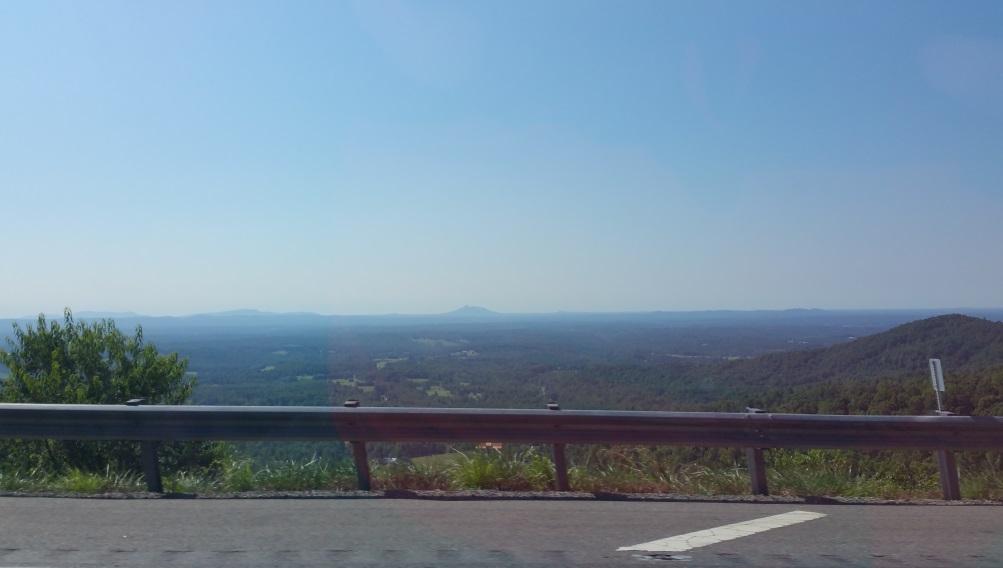
3 Transition from Blue Ridge/Appalachian Mountains to North Carolina Piedmont 1,000 elevation drop over 11 horizontal curves 4% grade Area subject to dense fog and severe cross winds rapid changes Lack of power and communications infrastructure Traffic Volume 38,000 AADT 25% trucks Speed Limit - 65 MPH I-77 at Fancy Gap Mountain 3


4 Problem Statement Motorists transition from sunny skies 4


5 To Thickening Fog MM 5.3, Visibility 197 ft MM 4.3, Visibility 430 ft MM 1.9, Visibility 2000 ft 5
6 Resulting in Rear-end Crashes Before Yes, this project is a image 39 Visibility crashes from??? a 63% traffic of Camera all Crashes were Rear Ends 6 year period 6
7 I-77 at Fancy Gap Mountain Significant Fog Related Incidents Date of Crash Vehicles Fatalities Injured Direction March 31, Southbound Nov. 16, Southbound Oct. 27, Southbound Sept. 25, Both Jan. 21, Both May 21, Southbound Jan. 18, N/A Southbound Oct. 5, Northbound Feb. 14, Southbound 16 years, 9 crashes, 482+ vehicles, 7 fatalities, 114+ injuries 7

8 March 31, 2013 Incident Summary 96 Total Vehicles Involved 17 Separate Crashes 15 Vehicles on Escape Ramp 3 Fatalities 10 hrs/ 42 min Incident Duration 167 feet Shortest Visibility >60 MPH Speeds 8

9 Previous Safety Improvements Increased Frequency of Skip Lines Diagonal striping on shoulders Increased frequency of roadway delineators Resulted in minimal safety benefit: Improvements addressed Run off the Road Crashes Did not address Rear End Crashes
10 Fog Characteristics Fog occurs 425+ hours /year (5%) Most likely from MM 4 to MM 7 Unpredictable any month, day, or hour 10
11 Monthly Climatology Days with less than 300 feet of visibility January February March April May June July August September October November December Limited visibility can occur during any month 11
 Count by Hour 2010-2014 Limited visibility can occur any")
12 Hourly Climatology Hours when visibility falls below 300 feet in that hour. (only one count per day per hour) Count by Hour Limited visibility can occur any hour of the day 12

13 Concept Development and Key Challenges Problem approach concept of operations Virginia Code Speed recommendations, changes, approach Scenario based modules fog, snow, wind Algorithm development Lack of power and communications infrastructure Data collection System monitoring and control Spreadsheet tool Field device polling/data acquisition Speed recommendations Sign operation


14 Fog on the road How the system works? Weather Station Traffic Operations Center Strategically placed weather detection stations determines sight distance When sight distance falls below visibility threshold Drivers slow down Speed limit reduced 14

 are in place")

15 Signs A total of 69 signs of various types (static, VMS, etc.) are in place in support of the variable speed limit system. 16

16 Corridor Device Map 17
17 Adjusted Step Model Speed (MPH) Collected Speeds Model Fit Adjusted - Day Model Fit Adjusted - Night 10 Speed = 69.7 (4059/visibility) *Day_Night - Step Visibility (feet) SSD 18

18 I-77 VSL Visibility Module 19


19 System Outputs Output for State Police Situational awareness, enforcement documentation Output to Vanguard DMS Software sign control Output to Datasummary file VA Code documentation 20

20 Results - Mean speeds are reduced Before Project After Project 21

21 Posted vs Observed Speed Differentials 24

22 Preliminary Results: Rear end crashes reduced Overall number of crashes reduced Reduction in crash severity Crash Data

23 Summary of Results Speed reductions lag until drivers enter fog Speeds still above posted speed limit but closer to safe stopping speeds Continuing analysis on compliance and crash experience 26
24 Chris McDonald 1596 Deborah Lane Salem, Virginia
Active Traffic & Safety Management System for Interstate 77 in Virginia. Chris McDonald, PE VDOT Southwest Regional Operations Director
 Active Traffic & Safety Management System for Interstate 77 in Virginia Chris McDonald, PE VDOT Southwest Regional Operations Director Interstate 77 at Fancy Gap Mountain Mile markers 0-15 Built in late
EXAMINATION OF THE SAFETY IMPACTS OF VARYING FOG DENSITIES: A CASE STUDY OF I-77 IN VIRGINIA
 0 0 0 EXAMINATION OF THE SAFETY IMPACTS OF VARYING FOG DENSITIES: A CASE STUDY OF I- IN VIRGINIA Katie McCann Graduate Research Assistant University of Virginia 0 Edgemont Road Charlottesville, VA 0 --
Weather Responsive Traffic Management. WYDOT VSL Project. October 2011
 Weather Responsive Traffic Management Portland, OR WYDOT VSL Project October 2011 Variable Speed Limits I 80 Background Information >50% of I 80 traffic in Wyoming is commercial vehicles Rural AADT 11,000
Investigation of Driver Speed Choice and Crash Characteristics During Low Visibility Events
 Investigation of Driver Speed Choice and Crash Characteristics During Low Visibility Events http://www.virginiadot.org/vtrc/main/online_reports/pdf/17-r4pdf KATIE McCANN Operations Planning Analyst Operations
Weather Responsive Traffic Management. Wyoming DOT Variable Speed Limit (VSL) Project. March 2012
 Project. March 2012") Weather Responsive Traffic Management Wyoming DOT Variable Speed Limit (VSL) Project March 2012 I-80 Background Information >50% of I-80 traffic in Wyoming is commercial vehicles Rural AADT 11,000 vehicles
Weather Responsive Traffic Management Wyoming DOT Variable Speed Limit (VSL) Project March 2012 I-80 Background Information >50% of I-80 traffic in Wyoming is commercial vehicles Rural AADT 11,000 vehicles
Impacts of the I-77 Variable Speed Limit System on Speed and Crash Characteristics During Low Visibility Conditions
 Impacts of the I-77 Variable Speed Limit System on Speed and Crash Characteristics During Low Visibility Conditions http://www.virginiadot.org/vtrc/main/online_reports/pdf/19-r6.pdf DANIELA E. GONZALES
Evaluation of NDDOT Fixed Automated Spray Technology (FAST) Systems November 24, 2009
 Systems November 24, 2009") Evaluation of NDDOT Fixed Automated Spray Technology (FAST) Systems November 4, 009 Shawn Birst, PE Program Director, ATAC Associate Research Fellow Upper Great Plains Transportation Institute North Dakota
Evaluation of NDDOT Fixed Automated Spray Technology (FAST) Systems November 4, 009 Shawn Birst, PE Program Director, ATAC Associate Research Fellow Upper Great Plains Transportation Institute North Dakota
Annual Collision Report
 2016 Annual Collision Report Contents The Annual Collision Report is a summary of statistics associated with traffic collisions that occurred in the City of Winnipeg. This information is provided by Manitoba
National Rural ITS Conference 2006
 National Rural ITS Conference 2006 Design of Automated Variable Speed Limits and Lane Assignments in Rural Areas Presented by: Tom Blaine P. E., POE New Mexico Department of Transportation Intelligent
Evaluation of fog-detection and advisory-speed system
 Evaluation of fog-detection and advisory-speed system A. S. Al-Ghamdi College of Engineering, King Saud University, P. O. Box 800, Riyadh 11421, Saudi Arabia Abstract Highway safety is a major concern
Responsive Traffic Management Through Short-Term Weather and Collision Prediction
 Responsive Traffic Management Through Short-Term Weather and Collision Prediction Presenter: Stevanus A. Tjandra, Ph.D. City of Edmonton Office of Traffic Safety (OTS) Co-authors: Yongsheng Chen, Ph.D.,
Jackson County 2013 Weather Data
 Jackson County 2013 Weather Data 61 Years of Weather Data Recorded at the UF/IFAS Marianna North Florida Research and Education Center Doug Mayo Jackson County Extension Director 1952-2008 Rainfall Data
STATISTICAL ANALYSIS OF LAW ENFORCEMENT SURVEILLANCE IMPACT ON SAMPLE CONSTRUCTION ZONES IN MISSISSIPPI (Part 1: DESCRIPTIVE)
") STATISTICAL ANALYSIS OF LAW ENFORCEMENT SURVEILLANCE IMPACT ON SAMPLE CONSTRUCTION ZONES IN MISSISSIPPI (Part 1: DESCRIPTIVE) Tulio Sulbaran, Ph.D 1, David Marchman 2 Abstract It is estimated that every
STATISTICAL ANALYSIS OF LAW ENFORCEMENT SURVEILLANCE IMPACT ON SAMPLE CONSTRUCTION ZONES IN MISSISSIPPI (Part 1: DESCRIPTIVE) Tulio Sulbaran, Ph.D 1, David Marchman 2 Abstract It is estimated that every
Quality Pavement Markings
 Quality Pavement Markings Idaho Asphalt Conference Moscow, Idaho October 26, 2006 Purpose of Pavement Markings Provide the visual information needed by the driver to guide their vehicle Ed Lagergren,,
TMC Monthly Operational Summary
 TMC Monthly Operational Summary March Bureau of Transportation Systems Management & Operations (TSMO) NH Department of Transportation s Mission Transportation excellence enhancing the quality of life in
TABLE -I RAINFALL RECORDED AT PORT BLAIR (MM) FROM 1949 TO 2009
 FROM 1949 TO 2009") A. RAINFALL TABLE -I RAINFALL RECORDED AT PORT BLAIR (MM) FROM 1949 TO 2009 MONTH/YEAR 1949 1950 1951 1952 1953 1954 1955 1956 1957 1958 JANUARY 0.0 0.8 82.5 0.0 26.9 37.3 71.4 46.2 10.2 28.7 FEBRUARY
A. RAINFALL TABLE -I RAINFALL RECORDED AT PORT BLAIR (MM) FROM 1949 TO 2009 MONTH/YEAR 1949 1950 1951 1952 1953 1954 1955 1956 1957 1958 JANUARY 0.0 0.8 82.5 0.0 26.9 37.3 71.4 46.2 10.2 28.7 FEBRUARY
Transportation Management Center s Mission
 Bureau of Transportation Systems Management & Operations (TSMO) NH Department of Transportation s Mission Transportation excellence enhancing the quality of life in New Hampshire. Transportation Management
TMC Monthly Operational Summary
 TMC Monthly Operational Summary July 1 Bureau of Transportation Systems Management & Operations (TSMO) NH Department of Transportation s Mission Transportation excellence enhancing the quality of life
WRTM and Active Transportation and Demand Management
 The Future of Transportation - 2010 APWA Annual Congress and Exposition WRTM and Active Transportation and Demand Management Weather Responsive Traffic Management Workshop October 7, 2011 Jim Hunt F d
Montmorency County Traffic Crash Data & Year Trends. Reporting Criteria
 June 2018 Revised 8/3/2018 2017 Reporting Criteria Please pay particular attention to the wording when interpreting the three levels of data gathered for this report. Crash The Crash Level analyzes data
WHEN IS IT EVER GOING TO RAIN? Table of Average Annual Rainfall and Rainfall For Selected Arizona Cities
 WHEN IS IT EVER GOING TO RAIN? Table of Average Annual Rainfall and 2001-2002 Rainfall For Selected Arizona Cities Phoenix Tucson Flagstaff Avg. 2001-2002 Avg. 2001-2002 Avg. 2001-2002 October 0.7 0.0
collision analyses...
 collision analyses. 28 INJURY SUMMARY YEAR COLLISION NON-INJURY INJURY FATAL TOTAL TOTAL PERCENT TOTAL PERCENT TOTAL PERCENT 2004 7410 5124 69.15% 2259 30.49% 27 0.36% 2005 6767 4538 67.06% 2214 32.72%
Montmorency County Traffic Crash Data & Year Trends. Reporting Criteria
 June 2017 Revised 10/3/17 2016 Reporting Criteria Please pay particular attention to the wording when interpreting the three levels of data gathered for this report. Crash The Crash Level analyzes data
Transportation Management Center s Mission
 Bureau of Transportation Systems Management & Operations (TSMO) NH Department of Transportation s Mission Transportation excellence enhancing the quality of life in New Hampshire. Transportation Management
Vehicle Motion Equations:
 1 Vehicle Motion Equations: v = at + v (2.2.4) x x = v2 2 v 2a (2.2.6) v 2 = v 2 + 2a(x x ) (2.2.6) x = 1 2 at2 + v t + x (2.2.7) D b = x cos α (2.2.10) x = vt D b = v 2 v 2 2g(f G) (2.2.14) e + f s =
PENNSTATE COMMONWEALTH OF PENNSYLVANIA DEPARTMENT OF TRANSPORTATION
 COMMONWEALTH OF PENNSYLVANIA DEPARTMENT OF TRANSPORTATION PENNDOT RESEARCH EFFECTIVENESS OF SPEED MINDERS IN REDUCING DRIVING SPEEDS ON RURAL HIGHWAYS IN PENNSYLVANIA PennDOT/MAUTC Partnership Research
Western States Rural Transportation Consortium Meeting. June 14, 2011
 Western States Rural Transportation Consortium Meeting June 14, 2011 1 Overview/Agenda Welcome / Introductions / Recent ITS Activities General Status of the WSRTC Clarus One Stop Shop Update Year 1 Incubator
Dust Storms in Arizona: The Challenge to Ensure Motorist Safety Jennifer Toth, P.E. Deputy Director for Transportation
 Dust Storms in Arizona: The Challenge to Ensure Motorist Safety Jennifer Toth, P.E. Deputy Director for Transportation Arizona Department of Transportation AASHTO Extreme Weather Event Symposium May 21,
Transportation and Road Weather
 Portland State University PDXScholar TREC Friday Seminar Series Transportation Research and Education Center (TREC) 4-18-2014 Transportation and Road Weather Rhonda Young University of Wyoming Let us know
Grade 6 Standard 2 Unit Test Astronomy
 Grade 6 Standard 2 Unit Test Astronomy Multiple Choice 1. Why does the air temperature rise in the summer? A. We are closer to the sun. B. The air becomes thicker and more dense. C. The sun s rays are
Drivers in Crashes Per 10K Population. *2013 Population of Michigan Counties (by single- year of age) not yet available from U.S.
 not yet available from U.S.") Delta County 165 Crash and Injuries by Month Month Fatal Injury Persons Property Damage Only Fatality Injury January 145 2 17 126 2 26 February 115 0 9 106 0 12 March 80 1 6 73 2 8 April 103 1 13 89 1
Delta County 165 Crash and Injuries by Month Month Fatal Injury Persons Property Damage Only Fatality Injury January 145 2 17 126 2 26 February 115 0 9 106 0 12 March 80 1 6 73 2 8 April 103 1 13 89 1
Drought Characterization. Examination of Extreme Precipitation Events
 Drought Characterization Examination of Extreme Precipitation Events Extreme Precipitation Events During the Drought For the drought years (1999-2005) daily precipitation data was analyzed to find extreme
New Jersey Department of Transportation Extreme Weather Asset Management Pilot Study
 New Jersey Department of Transportation Extreme Weather Asset Management Pilot Study Overview Prepared for: June 26, 2018 Introduction Overview of Pilot Study New Jersey s Climate New Jersey s Transportation
EVALUATION OF SAFETY PERFORMANCES ON FREEWAY DIVERGE AREA AND FREEWAY EXIT RAMPS. Transportation Seminar February 16 th, 2009
 EVALUATION OF SAFETY PERFORMANCES ON FREEWAY DIVERGE AREA AND FREEWAY EXIT RAMPS Transportation Seminar February 16 th, 2009 By: Hongyun Chen Graduate Research Assistant 1 Outline Introduction Problem
APPENDIX G-7 METEROLOGICAL DATA
 APPENDIX G-7 METEROLOGICAL DATA METEOROLOGICAL DATA FOR AIR AND NOISE SAMPLING DAYS AT MMR Monthly Normals and Extremes for Honolulu International Airport Table G7-1 MMR RAWS Station Hourly Data Tables
Mountain View Community Shuttle Monthly Operations Report
 Mountain View Community Shuttle Monthly Operations Report December 6, 2018 Contents Passengers per Day, Table...- 3 - Passengers per Day, Chart...- 3 - Ridership Year-To-Date...- 4 - Average Daily Ridership
The Climate of Kiowa County
 The Climate of Kiowa County Kiowa County is part of the Central Great Plains, encompassing some of the best agricultural land in Oklahoma. Average annual precipitation ranges from about 24 inches in northwestern
Colorado State University, Fort Collins, CO Weather Station Monthly Summary Report
 Colorado State University, Fort Collins, CO Weather Station Monthly Summary Report Month: December Year: 2017 Temperature: Mean T max was 47.2 F which is 4.4 above the 1981-2010 normal for the month. This
1.0 INTRODUCTION AND SUMMARY...
 TABLE OF CONTENTS 1.0 INTRODUCTION AND SUMMARY... 1 1.1 Purpose and Study Objective... 1 1.2 Executive Summary... 1 2.0 ROADWAY CONDITIONS... 5 2.1 Granville Parkway (South Intersection)... 8 2.2 Tuscany
Jackson County 2018 Weather Data 67 Years of Weather Data Recorded at the UF/IFAS Marianna North Florida Research and Education Center
 Jackson County 2018 Weather Data 67 Years of Weather Data Recorded at the UF/IFAS Marianna North Florida Research and Education Center Doug Mayo Jackson County Extension Director 1952-2008 Rainfall Data
FDOT Level 2 Roundabout b/c Evaluation
 FDOT Level 2 Roundabout b/c Evaluation This spreadsheet tool compares the cost of a roundabout to the cost of a traditional intersection, as specified by the user. A traditional intersection is defined
WEBER ROAD RESIDENTIAL DEVELOPMENT Single Family Residential Project
 WEBER ROAD RESIDENTIAL DEVELOPMENT Single Family Residential Project WEBER ROAD RESIDENTIAL DEVELOPMENT TRAFFIC IMPACT STUDY TABLE OF CONTENTS 1.0 Executive Summary Page 2.0 Introduction 2.1 DEVELOPMENT
Organized Chain-Up and VSL
 Organized Chain-Up and VSL Jim Mahugh, PE WSDOT SC Region Traffic Engineer North/West Passage VSL Peer Exchange January 28, 2015 Snoqualmie Pass 2 Limits of VSL EB: MP 48.12 to 66.56 WB: MP 46.69 to 66.90
Changing Hydrology under a Changing Climate for a Coastal Plain Watershed
 Changing Hydrology under a Changing Climate for a Coastal Plain Watershed David Bosch USDA-ARS, Tifton, GA Jeff Arnold ARS Temple, TX and Peter Allen Baylor University, TX SEWRU Objectives 1. Project changes
GREEN SHEET. California Department of Forestry and Fire Protection (CAL FIRE)
") GREEN SHEET California Department of Forestry and Fire Protection (CAL FIRE) Informational Summary Report of Serious CAL FIRE Injuries, Illnesses, Accidents and Near Serious Accidents Fire Engine Rollover
GREEN SHEET California Department of Forestry and Fire Protection (CAL FIRE) Informational Summary Report of Serious CAL FIRE Injuries, Illnesses, Accidents and Near Serious Accidents Fire Engine Rollover
What are Intelligent Transportation Systems? Major ITS Areas
 Intelligent Transportation Systems in Small Cities and Rural Areas Indiana Road School March 20, 2001 Steven Beningo Federal Highway Administration Midwestern Resource Center What are Intelligent Transportation
JEP John E. Jack Pflum, P.E. Consulting Engineering 7541 Hosbrook Road, Cincinnati, OH Telephone:
 JEP John E. Jack Pflum, P.E. Consulting Engineering 7541 Hosbrook Road, Cincinnati, OH 45243 Email: jackpflum1@gmail.com Telephone: 513.919.7814 MEMORANDUM REPORT Traffic Impact Analysis Proposed Soccer
Monroe County: Key West and Lower Keys
 FDOT PROJECT UPDATES June 15-21, 2015 Monroe County: Key West and Lower Keys Monroe County projects website: www.fdotmonroe.com Opt Out: If you no longer wish to receive these weekly notifications, please
Traffic Control Weather Policy
 Traffic Control Policy can plan a huge factor in our ability to set up, maintain and remove a closure safely. There are many weather factors that require consideration when traffic control is to be in
Cost-Benefit Analysis of the Pooled- Fund Maintenance Decision Support System: Case Study
 Cost-Benefit Analysis of the Pooled- Fund Maintenance Decision Support System: Case Study Zhirui Ye (WTI) Xianming Shi (WTI) Christopher K. Strong (City of Oshkosh) 12 th AASHTO-TRB TRB Maintenance Management
[Lee, 5(1): January 2018] ISSN DOI /zenodo Impact Factor
![[Lee, 5(1): January 2018] ISSN DOI /zenodo Impact Factor](/thumbs/95/126338257.jpg "[Lee, 5(1): January 2018] ISSN DOI /zenodo Impact Factor") GLOBAL JOURNAL OF ENGINEERING SCIENCE AND RESEARCHES EVALUATION OF IMPROVED VARIABLE SPEED LIMIT SIGNS UNDER FOGGY CONDITIONS Minsoo Jin 1, Sukki Lee *2, Wonil Park 3 & Chulyong Kim 4 1,3 Research Specialist,
GLOBAL JOURNAL OF ENGINEERING SCIENCE AND RESEARCHES EVALUATION OF IMPROVED VARIABLE SPEED LIMIT SIGNS UNDER FOGGY CONDITIONS Minsoo Jin 1, Sukki Lee *2, Wonil Park 3 & Chulyong Kim 4 1,3 Research Specialist,
8.1 Attachment 1: Ambient Weather Conditions at Jervoise Bay, Cockburn Sound
 8.1 Attachment 1: Ambient Weather Conditions at Jervoise Bay, Cockburn Sound Cockburn Sound is 20km south of the Perth-Fremantle area and has two features that are unique along Perth s metropolitan coast
The Climate of Payne County
 The Climate of Payne County Payne County is part of the Central Great Plains in the west, encompassing some of the best agricultural land in Oklahoma. Payne County is also part of the Crosstimbers in the
Table of Contents Introduction... 4 Study Area... 5
 Table of Contents Introduction... 4 Study Area... 5 Streets and s... 5 Traffic Volumes... 8 Recent and Anticipated Development... 10 Crash Analysis... 10 Projected Traffic Volumes... 11 Trip Generation...
NEWS RELEASE. Province boosts winter highway safety measures
 For Immediate Release 2018TRAN0045-000567 April 4, 2018 NEWS RELEASE Province boosts winter highway safety measures VICTORIA Following an intense winter, the is undertaking several improvements to make
The Weather Wire. Current Colorado Snowpack. Contents:
 The Weather Wire December 2018 Volume 25 Number 12 Contents: Current Colorado Snowpack Drought Monitor November Summary/Statistics December Preview Snowfall Totals Current Colorado Snowpack Although snowfall
TRAFFIC ALERT FOR WEEK OF February 4 8, 2008
 TRAFFIC ALERT FOR WEEK OF February 4 8, 2008 Highway work zones in the Staunton District The following is a list of highway work that might affect traffic in the Staunton transportation district during
The Climate of Murray County
 The Climate of Murray County Murray County is part of the Crosstimbers. This region is a transition between prairies and the mountains of southeastern Oklahoma. Average annual precipitation ranges from
PRELIMINARY DRAFT FOR DISCUSSION PURPOSES
 Memorandum To: David Thompson From: John Haapala CC: Dan McDonald Bob Montgomery Date: February 24, 2003 File #: 1003551 Re: Lake Wenatchee Historic Water Levels, Operation Model, and Flood Operation This
Road Safety Audit NH 10/Manning Hill Road, Winchester, NH Road Safety Audit NH 10/Manning Hill Road Winchester, NH
 Road Safety Audit NH 10/Manning Hill Road Winchester, NH August 31, 2009 0 1.0 Introduction 1.1 Scope and purpose of Road Safety Audit A Road Safety Audit (RSA) is a formal, proactive safety performance
The Climate of Grady County
 The Climate of Grady County Grady County is part of the Central Great Plains, encompassing some of the best agricultural land in Oklahoma. Average annual precipitation ranges from about 33 inches in northern
Historical Patterns In Loss-of-Control Events At Specific Road Locations
 Historical Patterns In Loss-of-Control Events At Specific Road Locations Posting Date: April 2, 2018 As demonstrated in previous research by Gorski Consulting, police collision data is not likely to be
Jackson County 2014 Weather Data
 Jackson County 2014 Weather Data 62 Years of Weather Data Recorded at the UF/IFAS Marianna North Florida Research and Education Center Doug Mayo Jackson County Extension Director 1952-2008 Rainfall Data
The Climate of Texas County
 The Climate of Texas County Texas County is part of the Western High Plains in the north and west and the Southwestern Tablelands in the east. The Western High Plains are characterized by abundant cropland
Brandywine Road Speed Study FINAL REPORT
 Brandywine Road Speed Study FINAL REPORT City of Albuquerque Brandywine Road Speed Study Final Report Albuquerque, New Mexico City of Albuquerque May, 2016 Brandywine Road Speed Study Final Report City
The Climate of Marshall County
 The Climate of Marshall County Marshall County is part of the Crosstimbers. This region is a transition region from the Central Great Plains to the more irregular terrain of southeastern Oklahoma. Average
The Climate of Bryan County
 The Climate of Bryan County Bryan County is part of the Crosstimbers throughout most of the county. The extreme eastern portions of Bryan County are part of the Cypress Swamp and Forest. Average annual
P7.7 A CLIMATOLOGICAL STUDY OF CLOUD TO GROUND LIGHTNING STRIKES IN THE VICINITY OF KENNEDY SPACE CENTER, FLORIDA
 P7.7 A CLIMATOLOGICAL STUDY OF CLOUD TO GROUND LIGHTNING STRIKES IN THE VICINITY OF KENNEDY SPACE CENTER, FLORIDA K. Lee Burns* Raytheon, Huntsville, Alabama Ryan K. Decker NASA, Marshall Space Flight
Champaign-Urbana 2000 Annual Weather Summary
 Champaign-Urbana 2000 Annual Weather Summary ILLINOIS STATE WATER SURVEY 2204 Griffith Dr. Champaign, IL 61820 wxobsrvr@sws.uiuc.edu Maria Peters, Weather Observer January: January started on a mild note,
CHARACTERISTICS OF TRAFFIC ACCIDENTS IN COLD, SNOWY HOKKAIDO, JAPAN
 CHARACTERISTICS OF TRAFFIC ACCIDENTS IN COLD, SNOWY HOKKAIDO, JAPAN Motoki ASANO Director Traffic Engineering Division Civil Engineering Research Institute of 1-3 Hiragishi, Toyohira-ku, Sapporo, 062-8602,
APPENDIX M LAKE ELEVATION AND FLOW RELEASES SENSITIVITY ANALYSIS RESULTS
 APPENDIX M LAKE ELEVATION AND FLOW RELEASES SENSITIVITY ANALYSIS RESULTS Appendix M Lake Elevation and Flow Releases Sensitivity Analysis Results Figure M-1 Lake Jocassee Modeled Reservoir Elevations (Current
Local Calibration Factors for Implementing the Highway Safety Manual in Maine
 Local Calibration Factors for Implementing the Highway Safety Manual in Maine 2017 Northeast Transportation Safety Conference Cromwell, Connecticut October 24-25, 2017 MAINE Darryl Belz, P.E. Maine Department
The Climate of Haskell County
 The Climate of Haskell County Haskell County is part of the Hardwood Forest. The Hardwood Forest is characterized by its irregular landscape and the largest lake in Oklahoma, Lake Eufaula. Average annual
The Climate of Pontotoc County
 The Climate of Pontotoc County Pontotoc County is part of the Crosstimbers. This region is a transition region from the Central Great Plains to the more irregular terrain of southeast Oklahoma. Average
Chill Hour Assessment for the Yuma Area
 Chill Hour Assessment for the Yuma Area Item Type text; Article Authors Brown, Paul W. Publisher College of Agriculture, University of Arizona (Tucson, AZ) Journal Deciduous Fruit and Nut: A College of
LEVERAGING HIGH-RESOLUTION TRAFFIC DATA TO UNDERSTAND THE IMPACTS OF CONGESTION ON SAFETY
 LEVERAGING HIGH-RESOLUTION TRAFFIC DATA TO UNDERSTAND THE IMPACTS OF CONGESTION ON SAFETY Tingting Huang 1, Shuo Wang 2, Anuj Sharma 3 1,2,3 Department of Civil, Construction and Environmental Engineering,
Colorado State University, Fort Collins, CO Weather Station Monthly Summary Report
 Colorado State University, Fort Collins, CO Weather Station Monthly Summary Report Month: December Year: 2016 Temperature: Mean T max was 39.7 F which is 3.1 below the 1981-2010 normal for the month. This
Winter Maintenance on Ontario s Highways
 Ministry of Transportation Winter Maintenance on Ontario s Highways MTO Eastern Region November 18, 2015, Northumberland County Council Outline 1. Winter Maintenance Areas - Eastern Region 2. Winter Maintenance
IN-NETWORK CHLORINE RESIDUAL MANAGEMENT
 IN-NETWORK CHLORINE RESIDUAL MANAGEMENT Using GIS to assess flush point efficacy Ian Toohey, P.E. Systems Planning Austin Water TABLE OF CONTENTS 1. Background 3. Surface Creation 2. Residual Sampling
Third Grade Math and Science DBQ Weather and Climate/Representing and Interpreting Charts and Data - Teacher s Guide
 Third Grade Math and Science DBQ Weather and Climate/Representing and Interpreting Charts and Data - Teacher s Guide A document based question (DBQ) is an authentic assessment where students interact with
MODELING OF 85 TH PERCENTILE SPEED FOR RURAL HIGHWAYS FOR ENHANCED TRAFFIC SAFETY ANNUAL REPORT FOR FY 2009 (ODOT SPR ITEM No.
 MODELING OF 85 TH PERCENTILE SPEED FOR RURAL HIGHWAYS FOR ENHANCED TRAFFIC SAFETY ANNUAL REPORT FOR FY 2009 (ODOT SPR ITEM No. 2211) Submitted to: Ginger McGovern, P.E. Planning and Research Division Engineer
The Climate of Seminole County
 The Climate of Seminole County Seminole County is part of the Crosstimbers. This region is a transition region from the Central Great Plains to the more irregular terrain of southeastern Oklahoma. Average
Solar Powered Illuminated RPMs
 Report Title Report Date: 2000 Solar Powered Illuminated RPMs Principle Investigator Name Meyer, Eric Affiliation Meyer ITS Address 2617 W 27th Terrace Lawrence, KS 66047 Vendor Name and Address Interplex
Local Ctimatotogical Data Summary White Hall, Illinois
 SWS Miscellaneous Publication 98-5 STATE OF ILLINOIS DEPARTMENT OF ENERGY AND NATURAL RESOURCES Local Ctimatotogical Data Summary White Hall, Illinois 1901-1990 by Audrey A. Bryan and Wayne Armstrong Illinois
Smoke Fog Superfog - Smoke and Fog mixture Heavy rain and wind
 Smoke Fog Superfog - Smoke and Fog mixture Heavy rain and wind Florida Highway Patrol Training Academy Fog forms when water evaporates from a surface or is added to the air. Super fog is a combination
Wind Resource Data Summary Cotal Area, Guam Data Summary and Transmittal for December 2011
 Wind Resource Data Summary Cotal Area, Guam Data Summary and Transmittal for December 2011 Prepared for: GHD Inc. 194 Hernan Cortez Avenue 2nd Floor, Ste. 203 Hagatna, Guam 96910 January 2012 DNV Renewables
Subject: Desert Palisades Specific Plan - Tram Way Access Sight Distance
 Endo Engineering Traffic Engineering Air Quality Studies Noise Assessments July 13, 2015 Mr. Ed Freeman Pinnacle View, LLC P.O. Box 1754 Lake Oswego, OR 97035-0579 Subject: Desert Palisades Specific Plan
9. PROBABLE MAXIMUM PRECIPITATION AND PROBABLE MAXIMUM FLOOD
 9. PROBABLE MAXIMUM PRECIPITATION AND PROBABLE MAXIMUM FLOOD 9.1. Introduction Due to the size of Watana Dam and the economic importance of the Project to the Railbelt, the Probable Maximum Flood (PMF)
RICHARDS BAY CLEAN AIR ASSOCIATION
 RICHARDS BAY CLEAN AIR ASSOCIATION ANNUAL REPORT FOR THE PERIOD June 2006 to May 2007 For Attention: Mr. Q. Hurt Report Date: September 2007 Project Leader: Project Officers: H J Annegarn L. Khumalo T.
I-95/I-85 INTERCHANGE ROADWAY SAFETY ASSESSMENT
 FINAL REPORT I-95/I-85 INTERCHANGE ROADWAY SAFETY ASSESSMENT Prepared for: Prepared by: 117306012.B MARCH 2013 Final Report March 2013 I-95/I-85 Interchange ROADWAY SAFETY ASSESSMENT Prepared for: Prepared
Effectiveness of Seasonal Deer Advisories on Changeable Message Signs as a Deer Crash Reduction Tool
 Effectiveness of Seasonal Deer Advisories on Changeable Message Signs as a Deer Crash Reduction Tool http://www.virginiadot.org/vtrc/main/online_reports/pdf/19-r8.pdf BRIDGET M. DONALDSON Associate Principal
Drought in Southeast Colorado
 Drought in Southeast Colorado Nolan Doesken and Roger Pielke, Sr. Colorado Climate Center Prepared by Tara Green and Odie Bliss http://climate.atmos.colostate.edu 1 Historical Perspective on Drought Tourism
Final Report. COMET Partner's Project. University of Texas at San Antonio
 Final Report COMET Partner's Project University: Name of University Researcher Preparing Report: University of Texas at San Antonio Dr. Hongjie Xie National Weather Service Office: Name of National Weather
Making a Climograph: GLOBE Data Explorations
 Making a Climograph: A GLOBE Data Exploration Purpose Students learn how to construct and interpret climographs and understand how climate differs from weather. Overview Students calculate and graph maximum
Monthly Magnetic Bulletin
 BRITISH GEOLOGICAL SURVEY Ascension Island Observatory Monthly Magnetic Bulletin December 2008 08/12/AS Crown copyright; Ordnance Survey ASCENSION ISLAND OBSERVATORY MAGNETIC DATA 1. Introduction Ascension
Winter Climate Forecast
 Winter 2018-2019 Climate Forecast 26 th Winter Weather Meeting, OMSI and Oregon AMS, Portland Kyle Dittmer Hydrologist-Meteorologist Columbia River Inter-Tribal Fish Commission Portland, Oregon Professor
Session 6: and Evaluation. M c Farland Management, LLC
 Session 6: Performance Measurement and Evaluation State of the Practice Overview 1 Why Evaluate WRTM Strategies Understand system performance and benefits Specific benefits directly attributable to WRTM
1st Annual Southwest Ohio Snow Conference April 8, 2010 Abner F. Johnson, Office of Maintenance - RWIS Coordinator
 1st Annual Southwest Ohio Snow Conference April 8, 2010 Abner F. Johnson, Office of Maintenance - RWIS Coordinator The Ohio Department of Transportation ODOT has approximately 5500 full-time employees
DAILY QUESTIONS 28 TH JUNE 18 REASONING - CALENDAR
 DAILY QUESTIONS 28 TH JUNE 18 REASONING - CALENDAR LEAP AND NON-LEAP YEAR *A non-leap year has 365 days whereas a leap year has 366 days. (as February has 29 days). *Every year which is divisible by 4
Case Histories and Practical Examples
 SUMMER SCHOOL SIIV 2012 - ROAD SAFETY MANAGEMENT Theoretical principles and practical application in the framework of the European Directive 2008/96/CE Catania 24-28 September 2012 Case Histories and Practical