Western States Rural Transportation Consortium Meeting. June 14, 2011
|
|
|
- Dwayne Lee
- 5 years ago
- Views:
Transcription
1 Western States Rural Transportation Consortium Meeting June 14,
2 Overview/Agenda Welcome / Introductions / Recent ITS Activities General Status of the WSRTC Clarus One Stop Shop Update Year 1 Incubator Project Update/Overview COATS Phase 4 Project Follow-up Other discussions (as needed) 2
3 Roundtable of Recent ITS Activities 3
4 General Status of the Western States Rural Transportation Consortium 4
5 Clarus One Stop Shop 5
6 Broad Agency Announcement No. DTFH61-10-R Posted by FHWA on March 15, 2010 Proposals Due April 14, 2010 The goal of this Broad Agency Announcement (BAA) is to support research and scientific study on the use of Clarus System data to improve surface transportation weather management/operations, create innovative interfaces, and/or develop new applications including weather-responsive traffic management tools. The FHWA anticipates making up to seven (7) awards, but reserves the right to make more or fewer than seven (7) awards. 6
7 WTI Proposal Proposal Submitted on Time Included signed letters of support from WSRTC member states: California, Oregon, Washington and Nevada GOAL: Expand the One-Stop-Shop Prototype to Cover all of California, Oregon, Washington and Nevada to address the shortcomings of current (multi-state) webbased weather information sources for travelers (and DOT personnel) Project awarded on 9/24/2010 7
8 Progress We re close to having the site ready for review by FHWA and Consortium members. We need to check functionality and address what is missing. In general, we have included all of the anticipated data sets, including coverage of Washington with nearly all layers. 8
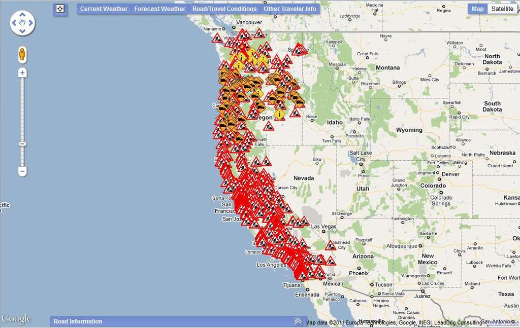
9 A Preview 9
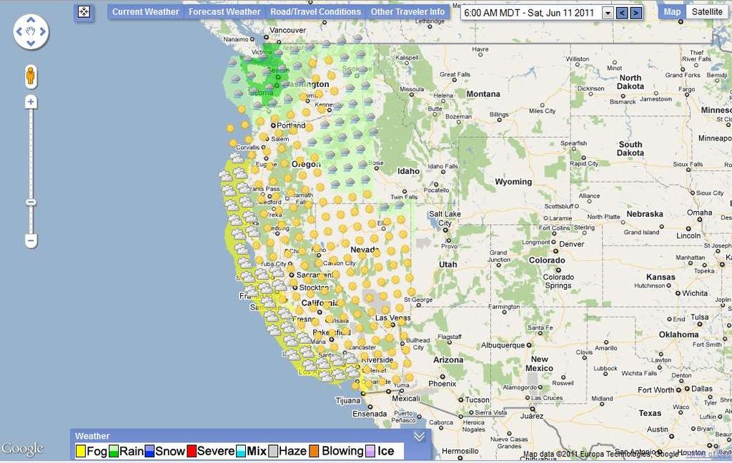
10 10


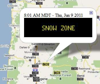
11 The Layers 11


12 Clarus Data 12
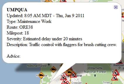
13 13
14 14


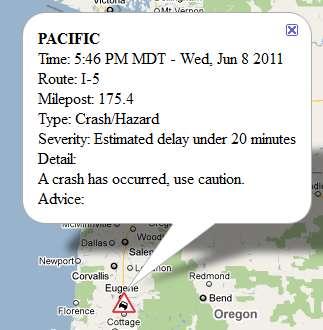
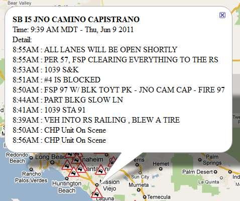
15 CCTV Images 15


16 16 Route Coverage: Los Angeles to Seattle


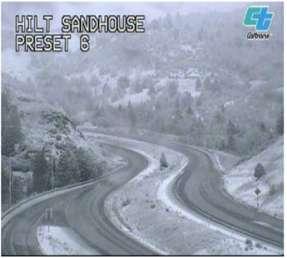

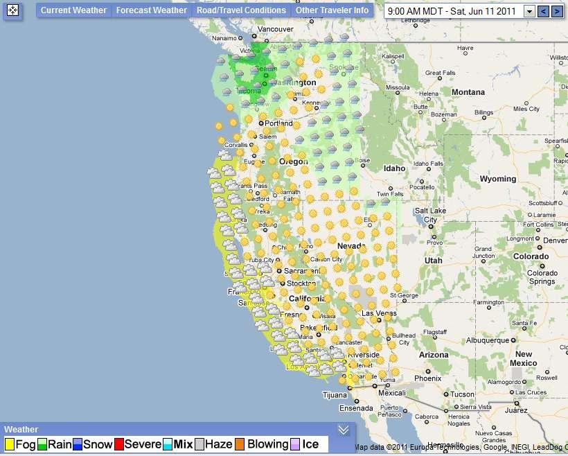
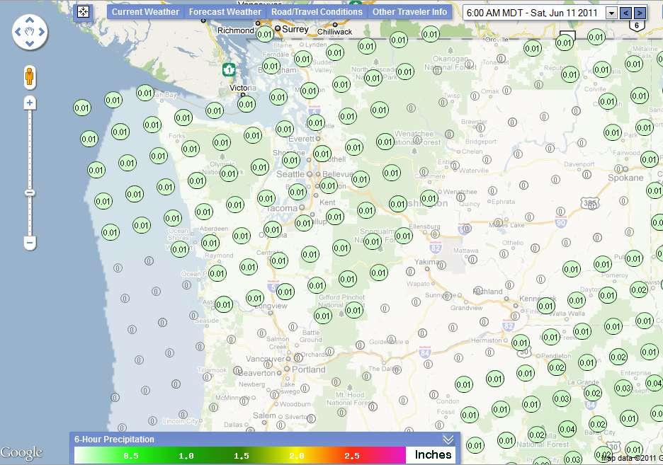
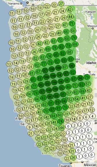
17 CCTV Images convey a lot of information 17
18 18 CMS


19 19
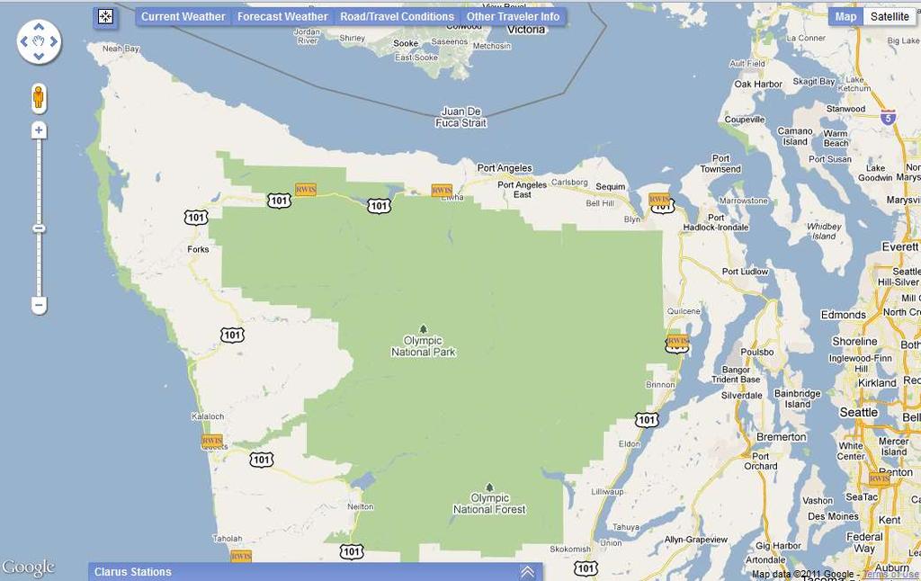
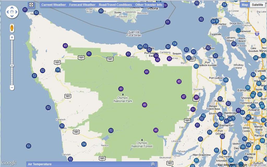
20 20 Road Information


21 21

22 22 Incidents


23 23

24 Weather Forecasts 24
25 25
26 26


27 Information at a Glance 27


28 28 Further Detail Upon Zoom
29 Brief Live Demonstration If time, network, etc. allow 29
30 Tasks and Deliverables Contract Start = 9/24/2010 Actual Start = 11/1/2010 End=9/23/2011 project 1 month System Concept Concept Report D Requirements Technical Memorandum Requirements D Design and Development Technical Memorandum System Design D Technical Memorandum System Documentation D Completed System D User Guide D Evaluation/User Survey Survey Instrument D Final Report D D Duration = 12 months Amount of Award = $79,995
31 Year 1 Incubators 31
32 Year One Projects Survey of Western State Safety Warning Devices Regional Integrated Corridor Management Planning Status Startup pending contract execution, anticipated June/July Workplans finalized 32
33 Survey of Safety Warning Devices Synthesis of existing safety warning devices in the western U.S. Contact entities to obtain specific information of interest Identify location of existing deployments, their function/purpose, and other info 33
34 Survey of Safety Warning Devices Approach Identify devices of interest and develop questionnaire Work in conjunction with WSRTC members Identify and contact agencies/staff Personal contact via telephone calls Summarize data and produce report 12 month timeline 34
35 Regional ICM Planning Revised based on steering comm. Feedback at November meeting Establish guidance and criteria to initiate, plan and develop rural ICM plans Define what rural ICM is and establish factors to consider Apply results of USDOT Integrated Corridor Management initiative to the rural environment 35
36 Approach Regional ICM Planning Literature review Document current ICM planning protocols i.e. USDOT ICM initiative Document current emergency operations center protocols i.e. what are WSRTC agencies doing Develop rural ICM planning protocols/ process Solicit Steering Comm. feedback on candidate test route(s) 36
37 Regional ICM Planning Approach cont d Route inventory for selected route(s) Apply developed criteria to study route(s) Final report Timeline 12 months 37
38 COATS Phase 4 Project Updates Rural Deployment Assistance Fredonyer Pass Icy Curve Warning System (ICWS) 38
39 Rural Deployment Assistance: Analysis and Recommendations for Optimization and Deployment of WeatherShare and Related Web-Based Projects 39
40 Multiple Projects on a Similar Platform WeatherShare Integrated Corridor Management Clearinghouse (ICM) Caltrans One Stop Shop for Traveler Information Integration of Aviation Automated Weather Observation Systems (AWOS) with Roadside Weather Information Systems (RWIS) Clarus One Stop Shop WSRTC One Stop Shop (Phase 2) 40
41 Challenges Still in research and development mode need to move to production Fragmented code-base with a lot of redundant code, data, etc. Non-optimal code Lack of scalability Poor logging/tracking made analysis difficult. Hard to characterize use seasonal components, mixed user types, etc. Use has been relatively limited Need to plan for expanded coverage area Hosted at Montana State University 41
42 Analysis System Performance Networking (incoming and outgoing) Storage CPU Memory Implementation Software Database Documentation Support 42
43 Hosting Alternatives Dedicated Server Dynamic Cloud Server Elastic Cloud Server 43
44 Recommendations Implement optimizations such as server-side compression of text files Determine whether or not archiving is necessary Re-factor code Put greater emphasis on system documentation, on-going support, maintenance, re-use and scalability Investigate hosting options further, particularly elastic options dynamic expansion 44
45 Fredonyer Pass Icy Curve Warning System 45
46 Fredonyer ICWS Project objective: evaluate the operational, safety and maintenance aspects of the ICWS Status: Revising analysis to incorporate chain control data and finishing report Preliminary results: indicate system appears to have reduced crashes and lowered speeds 46
47 Tasks: Fredonyer ICWS Literature review update Analysis of radar speed data Analysis of crash data Document maintenance aspects 47
48 Fredonyer ICWS Crash Analysis Examine crash data and trends before and after the deployment of ICWS Used observational before-after study method employing the Empirical Bayes technique Addresses concerns such as regression to the mean, changes in traffic flow, and other factors Used 4.5 years of before data (January 1, 1998 June 30, 2002) and 1.5 years of after data (July 1, 2008 December 31, 2009) 48
49 Fredonyer ICWS Crash Analysis Results Calculating the index of effectiveness (θ), ICWS reduced crashes by 18% during after period (annual) Assumption that changes in crashes attributed to presence of the ICWS, as no other geometric or safety improvements were made during the study period Ongoing work examining chain control status and crashes has indicated that only two crashes occurred shortly before R-1 chain control implemented (data available from ) 49
50 Fredonyer ICWS Crash Analysis Observed crash rates by severity also improved Crash Rate (ice-related crashes per winter season) Study Period Total PDO Injury Fatality Fatality + Injury (F+I) Before After Indicates that vehicles may be traveling slower = lower severity Based on these improvements, estimated safety benefit of $1.7 million 50
51 Fredonyer ICWS Speed Analysis T-tests employed to determine statistical significance between speeds Speeds differences of 0 mph, 3 mph and 5 mph examined Speeds evaluated for system state (on/off), day/night and weather 51
52 Fredonyer ICWS Speed Analysis System state Speeds were significantly lower at 0 mph, 3 mph and 5 mph when system was on Day/Night Speeds were significantly lower at 0 mph, 3 mph and 5 mph when system was on during both day and night 52
53 Fredonyer ICWS Speed Analysis Weather Speeds were significantly lower at 0 mph, 3 mph and 5 mph when system was on during both day and night Day - mean speeds fell between 6.20 mph and Night - mean speeds fell between mph and mph 53
54 Fredonyer ICWS Speed Analysis Clear Cold Dry/Not Dry Mean speeds different at 0 mph during day and night when signs on Mean speeds different at 3 mph during day and night when signs on Only limited number of mean speed differences greater than 5 mph Appears ICWS prompts approximately 3 mph speed reductions when icy roads are not necessarily expected 54
55 Fredonyer ICWS Conclusions Crashes initial results indicate that crashes have been reduced by approximately 18% Only evaluated 1 ½ years of after data Speeds system appears to reduce speeds by approximately 3 mph during clear, cold and not dry conditions Results pertain to sites prior to curves; greater reductions are possible/hypothesized as vehicles traverse curves 55
56 Discussion 56
57 Items Upcoming meetings Next Consortium meeting August at NRITS in Coeur d Alene, Idaho Scheduled for Wednesday, August 31 st from 1:00 4:00 PDT November Steering Committee Meeting tentatively scheduled for November 8, 2011 in Yreka 57
58 Wrap-up 58
Deploying the Winter Maintenance Support System (MDSS) in Iowa
 in Iowa") Deploying the Winter Maintenance Support System (MDSS) in Iowa Dennis A. Kroeger Center for Transportation Research and Education Iowa State University Ames, IA 50010-8632 kroeger@iastate.edu Dennis Burkheimer
Deploying the Winter Maintenance Support System (MDSS) in Iowa Dennis A. Kroeger Center for Transportation Research and Education Iowa State University Ames, IA 50010-8632 kroeger@iastate.edu Dennis Burkheimer
Transportation and Road Weather
 Portland State University PDXScholar TREC Friday Seminar Series Transportation Research and Education Center (TREC) 4-18-2014 Transportation and Road Weather Rhonda Young University of Wyoming Let us know
National Rural ITS Conference 2006
 National Rural ITS Conference 2006 Design of Automated Variable Speed Limits and Lane Assignments in Rural Areas Presented by: Tom Blaine P. E., POE New Mexico Department of Transportation Intelligent
VIRGINIA S I-77 VARIABLE SPEED LIMIT SYSTEM FOR LOW VISIBILITY CONDITIONS
 VIRGINIA S I-77 VARIABLE SPEED LIMIT SYSTEM FOR LOW VISIBILITY CONDITIONS Christopher D. McDonald, PE, PTOE Regional Operations Director, Southwest Region NRITS and ITS Arizona Annual Conference October
Western States One-Stop Shop for Rural Traveler Information Research on Clarus System Data
 Western States One-Stop Shop for Rural Traveler Information Research on Clarus System Data www.its.dot.gov/index.htm Final Report September 30, 2011 FHWA-JPO-11-153 Produced by FHWA Road Weather Management
Steven Chien Kung-E Cheng New Jersey Institute of Technology. David Bowlby New Jersey Department of Transportation
 Steven Chien Kung-E Cheng New Jersey Institute of Technology David Bowlby New Jersey Department of Transportation The 11th MDSS Stakeholder Meeting Charlotte, NC September 16, 2009 NJ-MDSS Goals Improve
UDOT Weather Program Traffic Operations Center
 UDOT Weather Program Traffic Operations Center Presentation Goals You MUST account for weather in your Traffic Management program Provide you with information on proven tools and strategies You NEED a
Road Weather Management Program
 Road Weather Management Program AASHTO/TRB Joint Maintenance Conference: Highway Safety & Reliability (Winter Maintenance and Highway Safety and Reliability) 7/22/2015 Gabe Guevara. P.E. FHWA Office of
Caltrans Aviation Weather Information (AWI) from Surface Transportation and Concept to Aviation and Implementation
 from Surface Transportation and Concept to Aviation and Implementation") Caltrans Aviation Weather Information (AWI) from Surface Transportation and Concept to Aviation and Implementation Doug Galarus Senior Research Scientist Western Transportation Institute, Montana State
Caltrans Aviation Weather Information (AWI) from Surface Transportation and Concept to Aviation and Implementation Doug Galarus Senior Research Scientist Western Transportation Institute, Montana State
Weather Responsive Traffic Management. WYDOT VSL Project. October 2011
 Weather Responsive Traffic Management Portland, OR WYDOT VSL Project October 2011 Variable Speed Limits I 80 Background Information >50% of I 80 traffic in Wyoming is commercial vehicles Rural AADT 11,000
Responsive Traffic Management Through Short-Term Weather and Collision Prediction
 Responsive Traffic Management Through Short-Term Weather and Collision Prediction Presenter: Stevanus A. Tjandra, Ph.D. City of Edmonton Office of Traffic Safety (OTS) Co-authors: Yongsheng Chen, Ph.D.,
FHWA Road Weather Management Program Update
 FHWA Road Weather Management Program Update 2015 Winter Maintenance Peer Exchange Bloomington, MN September 21-25, 2015 Gabe Guevara FHWA Office of Operations Road Weather Management Team 2015 Winter Maintenance
Evaluating the Potential of Remote Sensing Rural Road and Travel Conditions
 82 TRANSPORTATION RESEARCH RECORD 1409 Evaluating the Potential of Remote Sensing Rural Road and Travel Conditions KEVIN A. FRENCH AND EUGENE M. WILSON Communication of current road and travel conditions
Evaluation of the Fredonyer Pass Icy Curve Warning System
 Evaluation of the Fredonyer Pass Icy Curve Warning System A Project Completed for Completion under the California Oregon Advanced Transportation System (COATS) Project Prepared by David Veneziano Ph.D.
USDOT Applications Utilizing RWIS
 USDOT Applications Utilizing RWIS Benjamin McKeever, P.E. Program Manager, Traveler Info & Road Weather Research & Innovative Technology Administration U.S. Department of Transportation September 4, 2008
facilitate and improve access to RWIS observations in Arizona, Idaho, Nevada, Montana, Utah, and Wyoming,
 Application of Local Data Assimilation in Complex Terrain FHWA/COMET Award No: S01-24244 Award Period: March 1, 2001- October 31, 2003 Principal Investigators: J. Horel, Mike Splitt, CIRP, University of
Session 6: and Evaluation. M c Farland Management, LLC
 Session 6: Performance Measurement and Evaluation State of the Practice Overview 1 Why Evaluate WRTM Strategies Understand system performance and benefits Specific benefits directly attributable to WRTM
The WeatherShare Project: Aggregation and Dissemination of Weather Information for Public Safety
 slide1 The WeatherShare Project: Aggregation and Dissemination of Weather Information for Public Safety National Rural ITS Conference 2006 Big Sky Montana Monday, August 14th, 2006 12:30 pm Session B4:
Speed Impacts of an Icy Curve Warning System. * Corresponding author. 6,181 words 5 tables and figures = 1,250 words 7,431 words total
 Speed Impacts of an Icy Curve Warning System David Veneziano Ph.D. Western Transportation Institute Montana State University P.O. Box 0 Bozeman, MT -0 Phone: (0) -0, Fax: (0) - Email: david.veneziano@coe.montana.edu
MeteoGroup RoadMaster. The world s leading winter road weather solution
 MeteoGroup RoadMaster The world s leading winter road weather solution Discover why RoadMaster is the world s leading winter road weather solution. Managing winter road maintenance means that you carry
Center for Transportation Research and Education. Winter Maintenance Operations & Maintenance Decision Support System TRANS 691 Seminar March 5, 2004
 Center for Transportation Research and Education Winter Maintenance Operations & Maintenance Decision Support System TRANS 691 Seminar March 5, 2004 1 Why Winter Maintenance? Weather related traffic accidents
Weather Information for Road Managers
 Weather Information for Road Managers by Paul A. Pisano, Lynette C. Goodwin and Andrew D. Stern How Does Weather Affect Roads? The complex interactions between weather and roads have major affects on traffic
Safety Effects of Icy-Curve Warning Systems
 Safety Effects of Icy-Curve Warning Systems Zhirui Ye, David Veneziano, and Ian Turnbull The California Department of Transportation (Caltrans) deployed an icy-curve warning system (ICWS) on a 5-mi section
LRS Task Force June 13, REVISION HISTORY
 North Carolina Department of Transportation Geographic Information Systems (GIS) Unit LINEAR REFERENCING SYSTEM (LRS) PROJECT DEFINITION Version 1.0 REVISION HISTORY Date Document Manager Revision Purpose
Meridian Environmental Technology, Inc.
 Meridian Environmental Technology, Inc. Providing Tomorrow s Technology Today Meridian is committed to the support of its clients through advancement of science and technology A National Leader in Road
Maintenance Decision Support System (MDSS): A Practical Tool for All Maintenance Managers. What is MDSS? Route Specific Information 4/28/ NASC
: A Practical Tool for All Maintenance Managers. What is MDSS? Route Specific Information 4/28/ NASC") Maintenance Decision Support System (MDSS): A Practical Tool for All Maintenance Managers Phillip Anderle Colorado Department of Transportation Ben Hershey & Bob Hart Meridian Environmental Technology,
Maintenance Decision Support System (MDSS): A Practical Tool for All Maintenance Managers Phillip Anderle Colorado Department of Transportation Ben Hershey & Bob Hart Meridian Environmental Technology,
COMPARATIVE EVALUATION OF AUTOMATED WIND WARNING SYSTEMS
 COMPARATIVE EVALUATION OF AUTOMATED WIND WARNING SYSTEMS Showcase Evaluation #15 : Safety Benefits By Christopher Strong, P.E. and Manjunathan Kumar, P.E. Western Transportation Institute College of Engineering
Weather Responsive Traffic Management. Wyoming DOT Variable Speed Limit (VSL) Project. March 2012
 Project. March 2012") Weather Responsive Traffic Management Wyoming DOT Variable Speed Limit (VSL) Project March 2012 I-80 Background Information >50% of I-80 traffic in Wyoming is commercial vehicles Rural AADT 11,000 vehicles
Weather Responsive Traffic Management Wyoming DOT Variable Speed Limit (VSL) Project March 2012 I-80 Background Information >50% of I-80 traffic in Wyoming is commercial vehicles Rural AADT 11,000 vehicles
Oregon Department of Transportation. Geographic Information Systems. Implementation Plan. Adopted November, 2000 By the GIS Steering Committee
 Oregon Department of Transportation Geographic Information Systems Implementation Plan Adopted November, 2000 By the GIS Steering Committee Introduction The Oregon Department of Transportation (ODOT) GIS
Plan for operational nowcasting system implementation in Pulkovo airport (St. Petersburg, Russia)
") Plan for operational nowcasting system implementation in Pulkovo airport (St. Petersburg, Russia) Pulkovo airport (St. Petersburg, Russia) is one of the biggest airports in the Russian Federation (150
Plan for operational nowcasting system implementation in Pulkovo airport (St. Petersburg, Russia) Pulkovo airport (St. Petersburg, Russia) is one of the biggest airports in the Russian Federation (150
Plow Camera and Location Sharing Practices. National Rural ITS Conference October 23, 2018
 Plow Camera and Location Sharing Practices National Rural ITS Conference October 23, 2018 Outline NWP Program Overview Project Background Purpose What we did State Summaries ID, MT, ND, MN, IA, PA Project
A Summary of State DOT GIS Activities. Presented at the 2004 AASHTO GIS-T Symposium Rapid City, SD
 A Summary of State DOT GIS Activities Presented at the 2004 AASHTO GIS-T Symposium Rapid City, SD Information Sources E-mail survey of state DOT GIS managers All 51 State DOTs (and DC) responded in 2004
Weather Information for Surface Transportation (WIST): Update on Weather Impacts and WIST Progress
: Update on Weather Impacts and WIST Progress") Weather Information for Surface Transportation (WIST): Update on Weather Impacts and WIST Progress Samuel P. Williamson Office of the Federal Coordinator for Meteorological Services and Supporting Research
Weather Information for Surface Transportation (WIST): Update on Weather Impacts and WIST Progress Samuel P. Williamson Office of the Federal Coordinator for Meteorological Services and Supporting Research
CITY OF BEAVER DAM SNOW & ICE REMOVAL POLICY
 CITY OF BEAVER DAM SNOW & ICE REMOVAL POLICY Revised January, 2016 Approved by Operations Committee: February 1, 2016 This snow and ice removal policy guides Public Works personnel with deicing, plowing,
WRTM and Active Transportation and Demand Management
 The Future of Transportation - 2010 APWA Annual Congress and Exposition WRTM and Active Transportation and Demand Management Weather Responsive Traffic Management Workshop October 7, 2011 Jim Hunt F d
Annual TTFO Meeting April 10, 2018 Michael J. Wittman, P.S. Chief Surveyor / GIS Coordinator
 Annual TTFO Meeting April 10, 2018 Michael J. Wittman, P.S. Chief Surveyor / GIS Coordinator Text Book Definition: Layman Terms: An organized collection of hardware, software and geographic data designed
HSIP FUNDING APPLICATION
 Page 1 Lucas County - Sylvania Ave at Centennial Rd DATE 5/1/2013 Project Information: COUNTY Lucas County LOCATION TYPE PROJECT SERVICE LIFE 20 years SEGMENT INFORMATION ROUTE BEGIN SLM END SLM PRESENT
NJDOT Pedestrian Safety Analysis Tool 2015 GIS T Conference
 NJDOT Pedestrian Safety Analysis Tool 2015 GIS T Conference NJDOT Pedestrian Safety Analysis Tool Justin Furch GIT Department Manager Michael Baker International Pedestrian Safety in NJ: Has the highest
A Proposed Driver Assistance System in Adverse Weather Conditions
 1 A Proposed Driver Assistance System in Adverse Weather Conditions National Rural ITS Conference Student Paper Competition Second runner-up Ismail Zohdy Ph.D. Student, Department of Civil & Environmental
10/18/2016 The Hoosier Co. Inc W. 86th Street, Indianapolis, IN
 10/18/2016 The Hoosier Co. Inc. 5421 W. 86th Street, Indianapolis, IN 46268 1 Today s Topics Weather impacts What is RWIS? How old is this tool? Key RWIS Technology/Innovation Key RWIS sensing parameters
Kansas Next Generation 911 Data Remediation Program. Esri Imagery Forum June 26, 2016
 Kansas Next Generation 911 Data Remediation Program Esri Imagery Forum June 26, 2016 Kansas NextGen 911 Project Overview Development of statewide Emergency Services IP Network (ESINet) GIS database development,
Help from above. used in road weather information. system (RWIS) applications and, to a lesser extent, as components of recent
 applications and, to a lesser extent, as components of recent") WINTER MAINTENANCE By Levi Ewan, Ahmed Al-Kaisy, Ph.D., P.E., and David Veneziano, Ph.D. Contributing Authors Help from above Noninvasive sensors assist with pavement condition Road weather sensors are
WINTER MAINTENANCE By Levi Ewan, Ahmed Al-Kaisy, Ph.D., P.E., and David Veneziano, Ph.D. Contributing Authors Help from above Noninvasive sensors assist with pavement condition Road weather sensors are
United States Multi-Hazard Early Warning System
 United States Multi-Hazard Early Warning System Saving Lives Through Partnership Lynn Maximuk National Weather Service Director, Central Region Kansas City, Missouri America s s Weather Enterprise: Protecting
Enterprise Linear Referencing at the NYS Department of Transportation
 Enterprise Linear Referencing at the NYS Department of Transportation One Highway Network to Support Many Business Processes May 9, 2018 May 9, 2018 2 Agenda An overview of Linear Referencing How NYSDOT
A Guideline for Training Patrol Staff Ontario Good Roads Association
 A Guideline for Training Patrol Staff Ontario Good Roads Association A Guideline for Training Patrol Staff Rationale A patroller is required to observe both weather and road conditions either in the field
GEOGRAPHIC INFORMATION SYSTEMS Session 8
 GEOGRAPHIC INFORMATION SYSTEMS Session 8 Introduction Geography underpins all activities associated with a census Census geography is essential to plan and manage fieldwork as well as to report results
ROAD PAVEMENT TEMPERATURES AND THEIR IMPACT ON TRAVEL DURING SNOW STORMS. Donald M. Moore, NOAA/NWS, Billings, MT; and R. J.
 ROAD PAVEMENT TEMPERATURES AND THEIR IMPACT ON TRAVEL DURING SNOW STORMS Donald M. Moore, NOAA/NWS, Billings, MT; and R. J. Miller 1. INTRODUCTION The National Weather Service issues a variety of products
2014 Annual Mitigation Plan Review Meeting
 2014 Annual Mitigation Plan Review Meeting Highland County EMA MEETING OBJECTIVES Understand Your Natural Disaster Risk Review of Previous Plans Current Plan Status Future Activity Plan/Needs of Each Community
Advanced GIS Applications in Transit
 Advanced GIS Applications in Transit Case Studies of Five Large Transit Agencies presented to GIS in Transit Conference presented by John Sutton, Ph.D. Cambridge Systematics, Inc. November 1, 2005 Transportation
Acquisition of Multi-Function Equipment at DIA: Conditions, Factors, Considerations & Integration. Presented by Mike Carlson September 20, 2012
 Acquisition of Multi-Function Equipment at DIA: Conditions, Factors, Considerations & Integration Presented by Mike Carlson September 20, 2012 1 Denver International Airport 5 Runways 12,000 /. (3,658m)
What is 511? Need for 511 Services. Development & Deployment of Regional Road and Weather Information Supporting 511 Traveler Services
 Development & Deployment of Regional Road and Weather Information Supporting 511 Traveler Services Leon F. Osborne University of North Dakota Regional Weather Information Center Grand Forks, ND David L.
Winter Maintenance on Ontario s Highways
 Ministry of Transportation Winter Maintenance on Ontario s Highways MTO Eastern Region November 18, 2015, Northumberland County Council Outline 1. Winter Maintenance Areas - Eastern Region 2. Winter Maintenance
Using Winter Severity Indices for Winter Maintenance Performance Management. TRB Winter Maintenance Committee AHD65
 Using Winter Severity Indices for Winter Maintenance Performance Management TRB Winter Maintenance Committee AHD65 https://sites.google.com/site/trbcommitteeahd65/ Max Perchanok July 29 2015 Winter Maintenance
Weather for the Road: a Mobile Solution
 Weather for the Road: a Mobile Solution Philippe Tissot & Darius Stephen Conrad Blucher Institute David Fonseca, Hoang Chau, Duc Tran, Laura Pulgarin & Selvy Letlora The Innovation Center Texas A&M University-Corpus
Annual Collision Report
 2016 Annual Collision Report Contents The Annual Collision Report is a summary of statistics associated with traffic collisions that occurred in the City of Winnipeg. This information is provided by Manitoba
Active Traffic & Safety Management System for Interstate 77 in Virginia. Chris McDonald, PE VDOT Southwest Regional Operations Director
 Active Traffic & Safety Management System for Interstate 77 in Virginia Chris McDonald, PE VDOT Southwest Regional Operations Director Interstate 77 at Fancy Gap Mountain Mile markers 0-15 Built in late
Synthetic Weather Radar: Offshore Precipitation Capability
 Synthetic Weather Radar: Offshore Precipitation Capability Mark S. Veillette 5 December 2017 Sponsors: Randy Bass, FAA ANG-C6 and Rogan Flowers, FAA AJM-33 DISTRIBUTION STATEMENT A: Approved for public
Snow and Ice Control POLICY NO. P-01/2015. CITY OF AIRDRIE Snow and Ice Control Policy
 Page 1 CITY OF AIRDRIE Snow and Ice Control Effective Date: Approved By: Approved On: March 17, 2015 City Council March 16, 2015 Revision Date: Resolution #: ------ PURPOSE: The City of Airdrie is responsible
Weather Responsive. in Maryland. Richard R. Dye Maryland State Highway Administration. Maryland State Highway Administration
 Weather Responsive Traffic Management in Maryland Richard R. Dye Maryland State Highway Administration i ti 1st Stakeholder Workshop on Weather Responsive Traffic Mgt October 6-7, 2011 1 RWIS Grew From
Organized Chain-Up and VSL
 Organized Chain-Up and VSL Jim Mahugh, PE WSDOT SC Region Traffic Engineer North/West Passage VSL Peer Exchange January 28, 2015 Snoqualmie Pass 2 Limits of VSL EB: MP 48.12 to 66.56 WB: MP 46.69 to 66.90
Comprehensive Winter Maintenance Management System BORRMA-web MDSS inside to increase Road Safety and Traffic Flow
 Thorsten Cypra 1 Comprehensive Winter Maintenance Management System BORRMA-web MDSS inside to increase Road Safety and Traffic Flow American Public Works Association (APWA) Monday, 04/14/2008 3:30 4:30
A Tale of Time Travel Year 2018
 A Tale of Time Travel Year 2018 1 1 Question: 2 2 Answer: Integrated Modeling for Road Condition Prediction (IMRCP) Kyle Garrett, Synesis Partners Nancy Powell, MoDOT/KC Scout 3 So what is it? Historic
INTEGRATING IMPROVED WEATHER FORECAST DATA WITH TFM DECISION SUPPORT SYSTEMS Joseph Hollenberg, Mark Huberdeau and Mike Klinker
 INTEGRATING IMPROVED WEATHER FORECAST DATA WITH TFM DECISION SUPPORT SYSTEMS Joseph Hollenberg, Mark Huberdeau and Mike Klinker The MITRE Corporation Center for Advanced Aviation System Development (CAASD)
The World Bank Heilongjiang Cold Weather Smart Public Transportation System (P133114)
") Public Disclosure Authorized EAST ASIA AND PACIFIC China Transport Global Practice IBRD/IDA Investment Project Financing FY 2014 Seq No: 2 ARCHIVED on 09-Dec-2014 ISR17411 Implementing Agencies: Heilongjiang
Public Disclosure Authorized EAST ASIA AND PACIFIC China Transport Global Practice IBRD/IDA Investment Project Financing FY 2014 Seq No: 2 ARCHIVED on 09-Dec-2014 ISR17411 Implementing Agencies: Heilongjiang
INTEGRATING IMPROVED WEATHER FORECAST DATA WITH TFM DECISION SUPPORT SYSTEMS Joseph Hollenberg, Mark Huberdeau and Mike Klinker
 INTEGRATING IMPROVED WEATHER FORECAST DATA WITH TFM DECISION SUPPORT SYSTEMS Joseph Hollenberg, Mark Huberdeau and Mike Klinker The MITRE Corporation Center for Advanced Aviation System Development (CAASD)
Cost-Benefit Analysis of the Pooled- Fund Maintenance Decision Support System: Case Study
 Cost-Benefit Analysis of the Pooled- Fund Maintenance Decision Support System: Case Study Zhirui Ye (WTI) Xianming Shi (WTI) Christopher K. Strong (City of Oshkosh) 12 th AASHTO-TRB TRB Maintenance Management
Evaluation of fog-detection and advisory-speed system
 Evaluation of fog-detection and advisory-speed system A. S. Al-Ghamdi College of Engineering, King Saud University, P. O. Box 800, Riyadh 11421, Saudi Arabia Abstract Highway safety is a major concern
EBS IT Meeting July 2016
 EBS IT Meeting 18 19 July 2016 Conference Call Details Conference call: UK Numbers Tel: 0808 238 9819 or Tel: 0207 950 1251 Participant code: 4834 7876... Join online meeting https://meet.nationalgrid.com/antonio.delcastillozas/hq507d31
2008 SEAUPG CONFERENCE-BIRMINGHAM, ALABAMA
 Introduction Overview M E E Design Inputs MEPDG Where are we now MEPDG Inputs, Outputs, and Sensitivity Southeast Asphalt User Producer Group Bill Vavrik 19 November 2008 2 Implementation Timeframe DARWin
Flood Map. National Dataset User Guide
 Flood Map National Dataset User Guide Version 1.1.5 20 th April 2006 Copyright Environment Agency 1 Contents 1.0 Record of amendment... 3 2.0 Introduction... 4 2.1 Description of the Flood Map datasets...4
Road Weather Research Mike Chapman
 Road Weather Research Mike Chapman mchapman@ucar.edu NCAR Research Applications Lab Boulder, CO Why Invest in Road Weather Research Safety Over 1,500,000, crashes occur each year during poor weather conditions,
Injury Related Morbidity and Mortality Following Tornadoes in Alabama on April 27, 2011: Survey Instrument Training
 Injury Related Morbidity and Mortality Following Tornadoes in Alabama on April 27, 2011: Survey Instrument Training Live Webcast Monday, November 7, 2011 1:00 3:00 p.m. Central Time Produced by the Alabama
Inclement Weather Preparedness. Tornadoes and Severe Thunderstorms
 Inclement Weather Preparedness Tornadoes and Severe Thunderstorms Let s find out How do we prepare ahead of time? What is the difference between a watch and a warning? What are the severe weather communications
Using GIS Online for tracking development of roadway construction plans. Tom Cox Viraj Perera
 Using GIS Online for tracking development of roadway construction plans Tom Cox Viraj Perera 9 Districts District 6 Located in the Capital City Springfield, IL LAND OF LINCOLN Home to: Abraham Lincoln
Dust Storms in Arizona: The Challenge to Ensure Motorist Safety Jennifer Toth, P.E. Deputy Director for Transportation
 Dust Storms in Arizona: The Challenge to Ensure Motorist Safety Jennifer Toth, P.E. Deputy Director for Transportation Arizona Department of Transportation AASHTO Extreme Weather Event Symposium May 21,
U.S. Geological Survey Agency Briefing for MAPPS Mark L. DeMulder Director, National Geospatial Program. March 12, 2013
 + U.S. Geological Survey Agency Briefing for MAPPS Mark L. DeMulder Director, National Geospatial Program March 12, 2013 + 3D Elevation Program (3DEP) National Leadership The National Enhanced Elevation
6TH ANNUAL BUILDING EMERGENCY PLAN SUMMIT
 CAMPUS EMERGENCY PREPAREDNESS TRAINING SERIES 6TH ANNUAL BUILDING EMERGENCY PLAN SUMMIT Ron Wright, Director Jefferson Howells, Asst Director Campus Emergency Preparedness & Planning Office 205 South Martin
Emergency Traffic Management In the Case of Severe Winter Conditioins
 Emergency Traffic Management In the Case of Severe Winter Conditioins Presentation on the Project Workshop Organizing Emergency Management Strategies for the Transport Sector with the Use of innovative
Tippecanoe County ARES Net Formats NET 1-4. Net Formats
 1. Introduction Net Formats To provide a basis for carrying out the mission of the Tippecanoe County, Indiana, Amateur Radio Emergency Service (ARES ), guidelines must be in place to meet the communications
INTEGRATED REMOTE SENSING AND VISUALIZATION (IRSV) SYSTEM FOR TRANSPORTATION INFRASTRUCTURE. Project Description and Year I Achievement Report
 SYSTEM FOR TRANSPORTATION INFRASTRUCTURE. Project Description and Year I Achievement Report") INTEGRATED REMOTE SENSING AND VISUALIZATION (IRSV) SYSTEM FOR TRANSPORTATION INFRASTRUCTURE OPERATIONS AND MANAGEMENT Project Description and Year I Achievement Report p PROJECT OVERVIEW Project Goals:
INTEGRATED REMOTE SENSING AND VISUALIZATION (IRSV) SYSTEM FOR TRANSPORTATION INFRASTRUCTURE OPERATIONS AND MANAGEMENT Project Description and Year I Achievement Report p PROJECT OVERVIEW Project Goals:
An Internet-Based Integrated Resource Management System (IRMS)
") An Internet-Based Integrated Resource Management System (IRMS) Third Quarter Report, Year II 4/1/2000 6/30/2000 Prepared for Missouri Department of Natural Resources Missouri Department of Conservation
An Internet-Based Integrated Resource Management System (IRMS) Third Quarter Report, Year II 4/1/2000 6/30/2000 Prepared for Missouri Department of Natural Resources Missouri Department of Conservation
A Regional Pilot Weather Information System for Surface Transportation and Incident Management
 Xianming Shi, Shaowei Wang, Ian Turnbull, Mandy Chu, and Stephen Albert 1 A Regional Pilot Weather Information System for Surface Transportation and Incident Management Xianming Shi, Ph.D.* Program Manager,
City of Saginaw Right of Way Division Snow and Ice Removal Policy January 18, 2016
 Snow and Ice Removal Policy January 18, 2016 It is the policy of the to provide snowplowing and ice removal services in order to: Provide safe traveling conditions for motorists and pedestrians Assist
MULTI-AGENCY COORDINATION SYSTEM PUBLICATION CALIFORNIA FIRE WEATHER PROGRAM RISK PREPAREDNESS GUIDE MACS 410-3
 MULTI-AGENCY COORDINATION SYSTEM PUBLICATION CALIFORNIA FIRE WEATHER PROGRAM RISK PREPAREDNESS GUIDE MACS 410-3 August 26, 2013 California Fire Weather Program Risk Preparedness Guide Table of Contents
Opportunities to Improve Work Zone & Road Weather Management with Connected Vehicles
 Connected Vehicle Tracking to Improve Operational Efficiency Opportunities to Improve Work Zone & Road Weather Management with Connected Vehicles August 26, 2015 Gabriel Guevara TRB Webinar: Connected
MTO s Road Weather Information System (RWIS)
") MTO s Road Weather Information System (RWIS) Ontario Good Roads Association Managing Winter Operations Workshop October 19, 2017 Overview of MTO s Road Weather Information Station (RWIS) RWIS for Winter
MTO s Road Weather Information System (RWIS) Ontario Good Roads Association Managing Winter Operations Workshop October 19, 2017 Overview of MTO s Road Weather Information Station (RWIS) RWIS for Winter
MDSS Functional Prototype Display System Preview April 2002
 MDSS Functional Prototype Display System Preview April 2002 Bill Mahoney National Center for Atmospheric Research Images shown are valid as of 15 April 2002 NCAR MDSS Display System - Overview The MDSS
Educational Objectives
 MDSS and Anti-Icing: How to Anti-Ice with Confidence Wilf Nixon, Ph.D., P.E. IIHR Hydroscience and Engineering University of Iowa Iowa City And Asset Insight Technologies, LLC Educational Objectives At
ELKO COUNTY WINTER MAINTENANCE AND SNOW REMOVAL POLICY RELATING TO THE ELKO COUNTY ROAD SYSTEM
 ELKO COUNTY WINTER MAINTENANCE AND SNOW REMOVAL POLICY RELATING TO THE ELKO COUNTY ROAD SYSTEM NOVEMBER 3, 2004 GENERAL The purpose of this policy is to set up acceptable procedures and policies for the
What are Intelligent Transportation Systems? Major ITS Areas
 Intelligent Transportation Systems in Small Cities and Rural Areas Indiana Road School March 20, 2001 Steven Beningo Federal Highway Administration Midwestern Resource Center What are Intelligent Transportation
Ice Hazard Mitigation and Monitoring on the Veterans Glass City Skyway Bridge
 Ice Hazard Mitigation and Monitoring on the Veterans Glass City Skyway Bridge Presenters: T. Audet, L. Istefan, D. Nims Authors: A. Abdelaal 1, D. Nims 1, L. Istefan 2, T. Audet 2, A. Helmicki 3, V. Hunt
Seasonal Hazard Outlook
 Winter 2016-2017 Current as of: October 21 Scheduled Update: December 614-799-6500 emawatch@dps.ohio.gov Overview Executive Summary Seasonal Forecast Heating Fuel Supply Winter Driving Preparedness Scheduled
REVISED UPDATED PREPARED DIRECT SAFETY ENHANCEMENT COST ALLOCATION TESTIMONY OF GARY LENART SAN DIEGO GAS & ELECTRIC COMPANY AND
 Application No: Exhibit No.: Witness: A.--00 ) In the Matter of the Application of San Diego Gas & ) Electric Company (U 0 G) and Southern California ) Gas Company (U 0 G) for Authority to Revise ) Their
MDSS and Advanced Forecasting STSMO Weather Workshop Dave Huft, SDDOT Research Program Manager September 12, 2017
 Connecting South Dakota and the Nation MDSS and Advanced Forecasting STSMO Weather Workshop Dave Huft, SDDOT Research Program Manager September 12, 2017 1 Weather Impacts & Strategies Winter perceived
Committee Meeting November 6, 2018
 Committee Meeting November 6, 2018 Agenda Where we are in the process Land Use Plan Transportation Element Housing & Neighborhoods Elements Next Steps Schedule November 6: Plan Elements December: Plan
NEWS RELEASE. Province boosts winter highway safety measures
 For Immediate Release 2018TRAN0045-000567 April 4, 2018 NEWS RELEASE Province boosts winter highway safety measures VICTORIA Following an intense winter, the is undertaking several improvements to make
GREEN SHEET. California Department of Forestry and Fire Protection (CAL FIRE)
") GREEN SHEET California Department of Forestry and Fire Protection (CAL FIRE) Informational Summary Report of Serious CAL FIRE Injuries, Illnesses, Accidents and Near Serious Accidents Fire Engine Rollover
GREEN SHEET California Department of Forestry and Fire Protection (CAL FIRE) Informational Summary Report of Serious CAL FIRE Injuries, Illnesses, Accidents and Near Serious Accidents Fire Engine Rollover
Economic and Social Council
 United Nations Economic and Social Council Distr.: General 2 July 2012 E/C.20/2012/10/Add.1 Original: English Committee of Experts on Global Geospatial Information Management Second session New York, 13-15
The Inter-Agency Space Debris Coordination Committee (IADC)
") The Inter-Agency Space Debris Coordination Committee (IADC) An overview of IADC s annual activities Mitsuru Ohnishi, JAXA, Japan IADC Chair www.iadc-online.org 55 th Session of the Scientific and Technical
The Inter-Agency Space Debris Coordination Committee (IADC) An overview of IADC s annual activities Mitsuru Ohnishi, JAXA, Japan IADC Chair www.iadc-online.org 55 th Session of the Scientific and Technical
Missouri River Basin Water Management
 Missouri River Basin Water Management US Army Corps of Engineers Missouri River Navigator s Meeting February 12, 2014 Bill Doan, P.E. Missouri River Basin Water Management US Army Corps of Engineers BUILDING