GEOGRAPHIC INFORMATION SYSTEMS Session 8
|
|
|
- Ariel West
- 6 years ago
- Views:
Transcription
1 GEOGRAPHIC INFORMATION SYSTEMS Session 8
2 Introduction Geography underpins all activities associated with a census Census geography is essential to plan and manage fieldwork as well as to report results GIS, GNSS (i.e., GPS), and the availability of affordable aerial and satellite imagery have enabled NSOs to collect more accurate and timely geospatial information about their populations GIS technology and other geospatial tools have enabled more efficient production of both enumerator maps and thematic maps of census results, improving the overall census data quality and supporting more efficient and impactful analysis of census data
3 The Global Statistical Geospatial Framework The importance of integrating statistical and geospatial data has been recognised at the international level, through the endorsement and adoption of the Five Global Statistical Geospatial Principles, under the Global Statistical Geospatial Framework (GSGF). 6th Session of the United Nations Committee of Experts on Global Geospatial Information Management (Augusts 2016) - Decision 6/107 Reiterated that the 2030 Agenda and the 2020 Round of Censuses are important drivers for the integration of geospatial and statistical information in support of evidence-based decision-making across many sectors, whether public or private, at the national and global levels, Adopted the five guiding principles as referenced in the report as the foundation of the Global Statistical Geospatial Framework,
4 The Five Principles of the Global Geospatial Statistical Framework: 1. Use of fundamental geospatial infrastructure and geocoding; 2. Geocoded unit record data in a data management environment; 3. Common geographies for dissemination of statistics; 4. Interoperable data and metadata standards; 5. Accessible and usable geospatially enabled statistics. Adds an X-Y coordinate (or several) for each unit of census data
5 Geocoding: Locating Census Data on a Map Principle 1 of the GSGF considers the use of fundamental geospatial infrastructure and geocoding. Geocoding provides a systematic approach to dealing with all geographies that underpin census operations through X-Y coordinates or polygons enumeration area, census block, a building, or parcel/property Geocoding is census data integration by another name: Establishes a consistent geography language through the systematic labelling of geographic phenomena Ensures that all census phenomena are linked to these geospatial entities through X-Y coordinates
6 Geocoding is vital for the census Geocoding is vital for producing high quality maps and performing census tasks such as: the operational planning of the census; modelling and delineating administrative and enumeration area boundaries; point locations of census units, even point locations of housing units and collective living quarters; locating other relevant geographic features such as roads, rivers and landmarks (which can be useful for delineating enumeration areas or for providing navigational information); and, supporting the dissemination, aggregation and disaggregation of data aggregate data into new/customized units of analysis satisfying users requirements; and, generate customizable map outputs.
7 Geographic Databases Geodatabases allows for data to be (re)utilised for future purposes and needs, including for creating new geographies in a time-efficient and geographically consistent manner A comprehensive census database usually consists the following elements: spatial boundary database, consisting of area features (polygons) that represent the census units (e.g. EAs and administrative/territorial/statistical divisions). geographic attributes table, a database file linked internally to the spatial database that contains one record for each polygon. This table contains the unique identifier for each census unit and possibly some additional static or unchanging variables, such as the unit s area in km 2. census data tables containing non-spatial attributes, i.e., the census indicators for the spatial census units. Each of these files must contain the unique identifier of the census unit that provides the link to the corresponding polygon attribute table records. There will be one record for each census unit. other vector (point or area) features, such as building/housing unit points, landmarks, roads, waterways, schools, health facilities or other buildings may be useful for orienting fieldworkers during the enumeration. Such features are usually recorded during preliminary field-canvassing or house-listing.
8 Role of geospatial information in census operations Role of maps in the census process has expanded Traditionally: to support enumeration, operations management and dissemination Today, modern GIS systems: improve efficiencies and accuracy of the overall census project and products optimize enumeration areas, workforce assignments and field offices cost savings (e.g. labour and transport)
9 Role of geospatial information in census operations: Pre-enumeration Creation/updates to census geographic database Creation/updates to Base Maps Creation of Map Services (this is the way to make maps available through the web) Creation or updating of enumeration areas (EAs) Production of digital EA maps for fieldwork and operations Use of remote sensed data (images from satellite and aerial imagery) in EA creation Integrating fieldwork using remote sensed data Validation of EA s Conducting GIS analysis to ensure complete and balanced coverage (no omissions or duplications) Applying GIS analysis to facilitate efficient census operations (analysis on most efficient placement of field offices and allocation of field workers
10 During enumeration: Workforce management Assign work to individual enumerators, monitor their activities and provide necessary assistance Improved time and resource management reduce labour costs optimize travel time, travel costs improve the overall quality of the census Create efficiencies and providing transparency across the workforce forecasting of workload and required staff management of working times suggest best possible scenarios for completion of work deploy technical or specialized skills and equipment
11 Complex scheduling analysis and assignments GIS solutions allow for complex scheduling analysis and assignments. optimize routes by determining quickest/shortest/most cost-effective route through EA find closest facilities in order to estimate cost of traveling between locations pre-plan routes, saving time, labour and fuel for transport

12 Example of daily optimized routes for one enumerator. The routes for each day are depicted in different colors and include the optimal stop sequence number for each site visit
13 During enumeration: Monitoring and operation management Support planning and control tasks by supervisors make assignments, reallocate tasks, with the aim of ensuring a smooth and timely completion of the enumeration real-time transmission of geo-data of enumerator route and household locations enable the supervisor to monitor the progress of the census enumeration locally facilitate better management of the enumerator s workload by checking the effective progress, comparing the actual completions rates compared with those expected identify problem areas and implement remedial action quickly knowing they are being monitored, the enumerators are discouraged from making any fraudulent returns, knowing that their outputs can be easily verified by the supervisor.
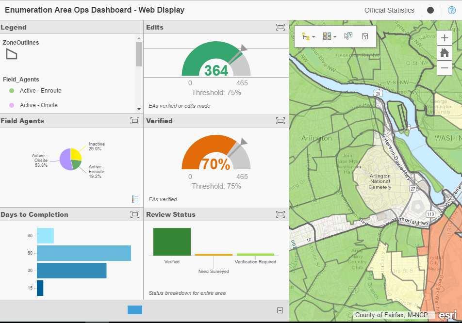
14 During enumeration: Monitoring and operation management GIS operational dashboards bring together a common view of the progress of the enumeration allow for monitoring of real-time data feeds for day-to-day operations monitoring progress at any level of geographic aggregation deliver information products needed throughout the operations processes including; maps, charts, and operational dashboards that provide an overview of the project status. Give decision makers updates on progress


15 Enforcing high data quality standards Example of an attempt to complete a questionnaire at a location beyond the boundary of an enumerator s EA
16 During enumeration: Support the work of enumerators Putting GIS mapping in the hands of the field staff improves the accuracy of census data. Ensure enumerators can easily identify their assigned geographic areas, follow a pre-determined path, and know their exact location in real time makes it easy for enumerators to organize their daily workloads by determining the optimum route to each household, report progress an alert function on the mobile application could ensure enumerators' safety through notification of supervisor in any emergency situations and the provision of support
17 During enumeration: Updating and correction of EA maps during enumeration Census maps are usually prepared several months, or even years, ahead of the actual enumeration new constructions and infrastructure developments may not be shown in the EA maps census maps may contain errors that may lead to either under- or over-coverage It is usual practice to verify EAs and units to be covered just prior to the actual enumeration. this round of validation of EAs is aimed verifying the existence of buildings and supplementing the address list with missing address points this data will allow the statistical agency to correct and update the digital maps in good time for the enumeration itself
18
19 Role of geospatial information in census operations: Post-enumeration GIS and interactive mapping capabilities make it easier to present, analyse and disseminate census results at various levels of geographical disaggregation Provides a powerful means for visualizing the results of a census - identification of patterns and the analysis of important demographic and social indicators Data at census unit level can be aggregated to new units of analysis (such as climatic zones or ethnic regions) Link information from many different subject areas, leading to a much wider use of statistical information Provide advanced visualization techniques, animation and three-dimensional modelling capabilities Make accessible vast amounts of spatial information to users through the Internet
20 Example: Geo-coding census and survey data and deep learning In 2016, Stanford researchers used geo-coded DHS data (with a significant scatter) to train a neural network to predict poverty rates by only looking at a satellite image The result: a function that would take a satellite image as an input, and (no other socioeconomic data) and output a poverty rate (wealth index) The model in its very earliest form had an R-squared of about 76%--using nothing but an image Computational sustainability researchers in the AI world are actively pursuing prototypes that use geospatial information for a range of incredibly innovative applications Expect the range of new uses of geocoded census information to expand dramatically over the next decade
21 Planning considerations for developing a census geographic program Key considerations include: Needs assessment Inventory of existing data sources Collection of new geographic data Geospatial data management system Identification of geographic products and services Staff skills and capacity Outsourcing
22 Inventory of existing data sources Identification of maps and other geographic information (both digital and hard-copy) reduce need to collect additional data using fieldwork and/or imagery save time by keeping field-checking to a minimum, and focusing on rapidly changing areas Cooperation with National Mapping Agencies, relevant government agencies, private sector Leverage resources of National Spatial Data Infrastructure (NSDI) institutions Data from external providers should be verified During incorporation into a GIS database, ensure the correct spatial relationships In order to ensure that these census maps can be integrated with other data sources, the census geographic programmes must adhere to existing national geospatial and geographic data standards
23 Staff skills and capacity Technical capacity and skills held by GIS staff critical Increased use of GIS packages requires considerable training Developing GIS capacity may entail reorganization and expanding the existing cartographic unit NSOs must evaluate training options Skills needed include: planning and project management; systems administration. geographical data conversion; map scanning and digitizing; cartographic design; field work with GNSS devices
Brazil Paper for the. Second Preparatory Meeting of the Proposed United Nations Committee of Experts on Global Geographic Information Management
 Brazil Paper for the Second Preparatory Meeting of the Proposed United Nations Committee of Experts on Global Geographic Information Management on Data Integration Introduction The quick development of
The Global Statistical Geospatial Framework and the Global Fundamental Geospatial Themes
 The Global Statistical Geospatial Framework and the Global Fundamental Geospatial Themes Sub-regional workshop on integration of administrative data, big data and geospatial information for the compilation
Geography for the 2020 Round of Census
 Boundaries Key Census Data EA Id Population Male Female EA Id Area EA Id Num HH Avg HH size Geography for the 2020 Round of Census Linda Peters, Esri lpeters@esri.com Integration of Statistical and Geospatial
Second High Level Forum on GGIM Seminar on Regional Cooperation in Geospatial Information Management Doha, Qatar, 7 February 2013
 Second High Level Forum on GGIM Seminar on Regional Cooperation in Geospatial Information Management Doha, Qatar, 7 February 2013 Overview on Geospatial Activities in Egypt BY : Eng.Nahla Seddik Mohamed
Economic and Social Council
 United Nations Economic and Social Council Distr.: General 2 July 2012 E/C.20/2012/10/Add.1 Original: English Committee of Experts on Global Geospatial Information Management Second session New York, 13-15
Combining Geospatial and Statistical Data for Analysis & Dissemination
 Combining Geospatial and Statistical Data for Analysis & Dissemination (with Special Reference to Qatar Census 2010) Presentation by Mansoor Al Malki, Director of IT Department Qatar Statistics Authority
Digitization in a Census
 Topics Connectivity of Geographic Data Sketch Maps Data Organization and Geodatabases Managing a Digitization Project Quality and Control Topology Metadata 1 Topics (continued) Interactive Selection Snapping
Presented to Sub-regional workshop on integration of administrative data, big data and geospatial information for the compilation of SDG indicators
 Presented to Sub-regional workshop on integration of administrative data, big data and geospatial information for the compilation of SDG indicators 23-25 April,2018 Addis Ababa, Ethiopia By: Deogratius
Land Use in the context of sustainable, smart and inclusive growth
 Land Use in the context of sustainable, smart and inclusive growth François Salgé Ministry of sustainable development France facilitator EUROGI vice president AFIGéO board member 1 Introduction e-content+
ArcGIS. for Server. Understanding our World
 ArcGIS for Server Understanding our World ArcGIS for Server Create, Distribute, and Manage GIS Services You can use ArcGIS for Server to create services from your mapping and geographic information system
Country Report on SDI Activities in Singapore *
 UNITED NATIONS E/CONF.100/CRP.9 ECONOMIC AND SOCIAL COUNCIL Eighteenth United Nations Regional Cartographic Conference for Asia and the Pacific Bangkok, 26-29 October 2009 Item 7(a) of the provisional
US National Spatial Data Infrastructure A Spatial Framework for Governance and Policy Development to Enable a Location-Based Digital Ecosystem
 GeoPlatform Workshop 7 Dec 2016, Department of the Interior Washington, D.C. US National Spatial Infrastructure A Spatial Framework for Governance and Policy Development to Enable a Location-Based Digital
Integration for Informed Decision Making
 Geospatial and Statistics Policy Intervention: Integration for Informed Decision Making Greg Scott Global Geospatial Information Management United Nations Statistics Division Department of Economic and
Foundation Geospatial Information to serve National and Global Priorities
 Foundation Geospatial Information to serve National and Global Priorities Greg Scott Inter-Regional Advisor Global Geospatial Information Management United Nations Statistics Division UN-GGIM: A global
Putting the U.S. Geospatial Services Industry On the Map
 Putting the U.S. Geospatial Services Industry On the Map December 2012 Definition of geospatial services and the focus of this economic study Geospatial services Geospatial services industry Allow consumers,
Disaster Management & Recovery Framework: The Surveyors Response
 Disaster Management & Recovery Framework: The Surveyors Response Greg Scott Inter-Regional Advisor Global Geospatial Information Management United Nations Statistics Division Department of Economic and
Implementing the Sustainable Development Goals: The Role of Geospatial Technology and Innovation
 Fifth High Level Forum on UN Global Geospatial Information Management Implementing the Sustainable Development Goals: The Role of Geospatial Technology and Innovation 28-30 November 2017 Sheraton Maria
Principle 3: Common geographies for dissemination of statistics Poland & Canada. Janusz Dygaszewicz Statistics Poland
 Principle 3: Common geographies for dissemination of statistics Poland & Canada Janusz Dygaszewicz Statistics Poland Reference materials Primary: Ortophotomap, Cadastral Data, Administrative division borders,
SUPPORTS SUSTAINABLE GROWTH
 DDSS BBUUN NDDLLEE G E O S P AT I A L G O V E R N A N C E P A C K A G E SUPPORTS SUSTAINABLE GROWTH www.digitalglobe.com BRISBANE, AUSTRALIA WORLDVIEW-3 30 CM International Civil Government Programs US
CENSUS MAPPING WITH GIS IN NAMIBIA. BY Mrs. Ottilie Mwazi Central Bureau of Statistics Tel: October 2007
 CENSUS MAPPING WITH GIS IN NAMIBIA BY Mrs. Ottilie Mwazi Central Bureau of Statistics E-mail: omwazi@npc.gov.na Tel: + 264 61 283 4060 October 2007 Content of Presentation HISTORICAL BACKGROUND OF CENSUS
Spatial Statistical Information Services in KOSTAT
 Distr. GENERAL WP.30 12 April 2010 ENGLISH ONLY UNITED NATIONS ECONOMIC COMMISSION FOR EUROPE (UNECE) CONFERENCE OF EUROPEAN STATISTICIANS EUROPEAN COMMISSION STATISTICAL OFFICE OF THE EUROPEAN UNION (EUROSTAT)
Census Undertaking in Pastoral Areas and Application of New Technologies in the 2007 Population and Housing Census
 Census Undertaking in Pastoral Areas and Application of New Technologies in the 2007 Population and Housing Census By: Yakob Mudesir Seid & Samia Zekaria Gutu Central Statistical Agency of Ethiopia Abstract
Oregon Department of Transportation. Geographic Information Systems Strategic Plan
 Oregon Department of Transportation Geographic Information Systems Strategic Plan Adopted May, 2000 By the GIS Steering Committee Last printed 10/2/2012 4:20:00 PM Page Geographic Information Systems Strategic
The Geospatial Census: plans and progress for the 2010 round of population censuses
 The Geospatial Census: plans and progress for the 2010 round of population censuses David Rain, Assistant Professor of Geography & International Affairs, and Consultant to the United Nations/UNSD drain@gwu.edu
Mission Report. Charles Brigham Reese GIS Specialist, UN Statistics Division
 Mission Report on The Geographic Preparatory Activities for the 2010 Population and Housing Census of Sri Lanka United Nations Statistics Division (22 24 September 2008) By Charles Brigham Reese GIS Specialist,
Egyptian E-Census 2017
 Egyptian E-Census 2017 Central Agency for Public Mobilization And Statistics An Integration between Spatial and Statistical information Prepared by: Nahla Seddik Mohamed General Director Mennat-Allah Anwar
Finding Common Ground Through GIS
 Finding Common Ground Through GIS Matthew Stone, MPH Special Unit for Technical Assistance Chronic Disease and Injury Control California Department of Public Health ESRI Health GIS Conference Scottsdale,
Economic and Social Council
 United Nations Economic and Social Council Distr.: General 18 July 2016 Original: English Committee of Experts on Global Geospatial Information Management Sixth session New York, 3-5 August 2016 Item 2
Economic and Social Council
 United Nations E/CN.3/2019/31 Economic and Social Council Distr.: General 19 December 2018 Original: English Statistical Commission Fiftieth session 5-8 March 2019 Item 4(i) of the provisional agenda*
Use of Geospatial Data: Philippine Statistics Authority 1
 Use of Geospatial Data: Philippine Statistics Authority 1 1 Presentation by Lisa Grace S. Bersales at the UNSC 2016 side event on Geospatial information and earth observations: supporting official statistics
Indicator: Proportion of the rural population who live within 2 km of an all-season road
 Goal: 9 Build resilient infrastructure, promote inclusive and sustainable industrialization and foster innovation Target: 9.1 Develop quality, reliable, sustainable and resilient infrastructure, including
APPLICATION OF GIS IN ELECTRICAL DISTRIBUTION NETWORK SYSTEM
 See discussions, stats, and author profiles for this publication at: https://www.researchgate.net/publication/305263658 APPLICATION OF GIS IN ELECTRICAL DISTRIBUTION NETWORK SYSTEM Article October 2015
GIS = Geographic Information Systems;
 What is GIS GIS = Geographic Information Systems; What Information are we talking about? Information about anything that has a place (e.g. locations of features, address of people) on Earth s surface,
Colin Bray, OSi CEO. Collaboration to develop a data platform for geospatial and statistical information in Ireland
 Colin Bray, OSi CEO Collaboration to develop a data platform for geospatial and statistical information in Ireland Organisations Ireland s National Mapping Agency Established in 1824 Operates under the
UTAH S STATEWIDE GEOGRAPHIC INFORMATION DATABASE
 UTAH S STATEWIDE GEOGRAPHIC INFORMATION DATABASE Data Information and Knowledge Management NASCIO Awards 2009 STATE GEOGRAPHIC INFORMATION DATABASE B. EXECUTIVE SUMMARY Utah has developed one of the most
GIS Workshop Data Collection Techniques
 GIS Workshop Data Collection Techniques NOFNEC Conference 2016 Presented by: Matawa First Nations Management Jennifer Duncan and Charlene Wagenaar, Geomatics Technicians, Four Rivers Department QA #: FRG
Spatial Data Infrastructure Concepts and Components. Douglas Nebert U.S. Federal Geographic Data Committee Secretariat
 Spatial Data Infrastructure Concepts and Components Douglas Nebert U.S. Federal Geographic Data Committee Secretariat August 2009 What is a Spatial Data Infrastructure (SDI)? The SDI provides a basis for
ENV208/ENV508 Applied GIS. Week 1: What is GIS?
 ENV208/ENV508 Applied GIS Week 1: What is GIS? 1 WHAT IS GIS? A GIS integrates hardware, software, and data for capturing, managing, analyzing, and displaying all forms of geographically referenced information.
Welcome. C o n n e c t i n g
 Welcome C o n n e c t i n g YOU D i s c i p l i n e s Why is This Meeting......So Important Now? OUR WORLD Is Increasingly Challenged The Evidence Is Clear We Need Better Understanding and More Collaboration
Oman NSDI Business Values and Future Directions. Hassan Alawi Alghazali Acting Director General National Spatial Data Infrastructure
 Oman NSDI Business Values and Future Directions Hassan Alawi Alghazali Acting Director General National Spatial Data Infrastructure Presentation Outline Geospatial Maturity Current Challenges NCSI s Role
Common geographies for dissemination of SDG Indicators
 5 th High Level Forum on United Nations GGIM, Mexico 2017 Common geographies for dissemination of SDG Indicators Understanding statistical and geodetic division of territory Janusz Dygaszewicz Central
GEOGRAPHICAL INFORMATION SYSTEMS. GIS Foundation Capacity Building Course. Introduction
 GEOGRAPHICAL INFORMATION SYSTEMS. GIS Foundation Capacity Building Course. Introduction In recent times digital mapping has become part and parcel of our daily lives with experience from Google Maps on
Health GIS Tools and Applications Informing Decisions in Yemen
 Health GIS Tools and Applications Informing Decisions in Yemen Prepared by: Carleen Ghio 1, Mark Landry 1, Abdulkadir Nueman 2, and Ahmed Attieg 3 Presented at: Map Middle East Conference April 23-25,
Economic and Social Council 2 July 2015
 ADVANCE UNEDITED VERSION UNITED NATIONS E/C.20/2015/11/Add.1 Economic and Social Council 2 July 2015 Committee of Experts on Global Geospatial Information Management Fifth session New York, 5-7 August
Preparing the GEOGRAPHY for the 2011 Population Census of South Africa
 Preparing the GEOGRAPHY for the 2011 Population Census of South Africa Sharthi Laldaparsad Statistics South Africa; E-mail: sharthil@statssa.gov.za Abstract: Statistics South Africa (Stats SA) s Geography
GIS Geographical Information Systems. GIS Management
 GIS Geographical Information Systems GIS Management Difficulties on establishing a GIS Funding GIS Determining Project Standards Data Gathering Map Development Recruiting GIS Professionals Educating Staff
STATE GEOGRAPHIC INFORMATION DATABASE
 STATE GEOGRAPHIC INFORMATION DATABASE Data Information and Knowledge Management STATE GEOGRAPHIC INFORMATION DATABASE EXECUTIVE SUMMARY Utah has developed one of the most comprehensive statewide GIS resources
IMPLEMENTING GOVERNMENT-WIDE ENTERPRISE GIS; THE FEDERATED MODEL
 IMPLEMENTING GOVERNMENT-WIDE ENTERPRISE GIS; THE FEDERATED MODEL James E. Mitchell, Ph. D. IT GIS Manager Louisiana Department of Transportation and Development presented at the ESRI International Users
Egypt Public DSS. the right of access to information. Mohamed Ramadan, Ph.D. [R&D Advisor to the president of CAPMAS]
![Egypt Public DSS. the right of access to information. Mohamed Ramadan, Ph.D. [R&D Advisor to the president of CAPMAS]](/thumbs/89/98483713.jpg "Egypt Public DSS. the right of access to information. Mohamed Ramadan, Ph.D. [R&D Advisor to the president of CAPMAS]") Egypt Public DSS ì the right of access to information Central Agency for Public Mobilization and Statistics Arab Republic of Egypt Mohamed Ramadan, Ph.D. [R&D Advisor to the president of CAPMAS] Egypt
Egypt Public DSS ì the right of access to information Central Agency for Public Mobilization and Statistics Arab Republic of Egypt Mohamed Ramadan, Ph.D. [R&D Advisor to the president of CAPMAS] Egypt
Realizing benefits of Spatial Data Infrastructure A user s perspective from Environment Agency - Abu Dhabi
 Realizing benefits of Spatial Data Infrastructure A user s perspective from Environment Agency - Abu Dhabi Anil Kumar Director, Environment Information Management 26 April 2012 Geospatial World Forum,
Cartographic and Geospatial Futures
 Cartographic and Geospatial Futures 1. Web Cartography, WebGIS, & Virtual Globes--New Roles for Maps, GIS, and GIS professionals 2. Map Mashups, the Neo Neo-geography Movement, & Crowd-sourcing Geospatial
Globally Estimating the Population Characteristics of Small Geographic Areas. Tom Fitzwater
 Globally Estimating the Population Characteristics of Small Geographic Areas Tom Fitzwater U.S. Census Bureau Population Division What we know 2 Where do people live? Difficult to measure and quantify.
OC Enterprise GIS. Kevin Hills, PLS Cameron Smith, GISP. OC Survey
 OC Enterprise GIS Kevin Hills, PLS Cameron Smith, GISP OC Survey Discussion Points Background & Organizational Structure of OCPW Past practices prior to Enterprise Wide GIS License (ELA) Participating
2007 / 2008 GeoNOVA Secretariat Annual Report
 2007 / 2008 GeoNOVA Secretariat Annual Report Prepared for: Assistant Deputy Minister and Deputy Minister of Service Nova Scotia and Municipal Relations BACKGROUND This report reflects GeoNOVA s ongoing
Bentley Map Advancing GIS for the World s Infrastructure
 Bentley Map Advancing GIS for the World s Infrastructure Presentation Overview Why would you need Bentley Map? What is Bentley Map? Where is Bentley Map Used? Why would you need Bentley Map? Because your
The econ Planning Suite: CPD Maps and the Con Plan in IDIS for Consortia Grantees Session 1
 The econ Planning Suite: CPD Maps and the Con Plan in IDIS for Consortia Grantees Session 1 1 Training Objectives Use CPD Maps to analyze, assess, and compare levels of need in your community Use IDIS
Integrating Official Statistics and Geospatial Information NBS Experience
 Integrating Official Statistics and Geospatial Information NBS Experience Presented by Eng. Reda AL Sabbagh Director of IT Dept. Prepared by Eng. Adham Makky GIS Specialist Topics to be covered: Background
2018 NASCIO Award Submission Category: Cross-Boundary Collaboration and Partnerships. Project Title: Tennessee Wildfires: A Coordinated GIS Response
 2018 NASCIO Award Submission Category: Cross-Boundary Collaboration and Partnerships Project Title: Tennessee Wildfires: A Coordinated GIS Response Sevier County, Tennessee State of Tennessee, Emergency
HIGH RESOLUTION BASE MAP: A CASE STUDY OF JNTUH-HYDERABAD CAMPUS
 HIGH RESOLUTION BASE MAP: A CASE STUDY OF JNTUH-HYDERABAD CAMPUS K.Manjula Vani, Abhinay Reddy, J. Venkatesh, Ballu Harish and R.S. Dwivedi ABSTRACT The proposed work High Resolution Base map: A Case study
BACHELOR OF GEOINFORMATION TECHNOLOGY (NQF Level 7) Programme Aims/Purpose:
 Programme Aims/Purpose:") BACHELOR OF GEOINFORMATION TECHNOLOGY ( Level 7) Programme Aims/Purpose: The Bachelor of Geoinformation Technology aims to provide a skilful and competent labour force for the growing Systems (GIS) industry
BACHELOR OF GEOINFORMATION TECHNOLOGY ( Level 7) Programme Aims/Purpose: The Bachelor of Geoinformation Technology aims to provide a skilful and competent labour force for the growing Systems (GIS) industry
Nomination Form. Clearinghouse. New York State Office for Technology. Address: State Capitol-ESP, PO Box
 NASIRE 2001 RECOGNITION AWARDS Recognizing Outstanding Achievement in the Field of Innovative Use of Technology Nomination Form Title of Nomination: Manager/Job Title: Agency: NYS Geographic Information
Oakland County Parks and Recreation GIS Implementation Plan
 Oakland County Parks and Recreation GIS Implementation Plan TABLE OF CONTENTS 1.0 Introduction... 3 1.1 What is GIS? 1.2 Purpose 1.3 Background 2.0 Software... 4 2.1 ArcGIS Desktop 2.2 ArcGIS Explorer
ArcGIS for Desktop. ArcGIS for Desktop is the primary authoring tool for the ArcGIS platform.
 ArcGIS for Desktop ArcGIS for Desktop ArcGIS for Desktop is the primary authoring tool for the ArcGIS platform. Beyond showing your data as points on a map, ArcGIS for Desktop gives you the power to manage
Better Topographic Map Production Using ArcGIS. A Comprehensive Solution for Mapping Organizations
 Better Topographic Map Production Using ArcGIS A Comprehensive Solution for Mapping Organizations The World Is Always Changing As a member of a national mapping organization, you know this is true. You
A proposal for building an infrastructure for European geospatial statistics
 A proposal for building an infrastructure for European geospatial statistics Marie Haldorson, Statistics Sweden Ekkehard Petri, Eurostat What is geospatial statistics? The location, extent or spatial relations
MALDIVES. Regional Expert Workshop On Land Accounting For SDG Monitoring & Reporting (25-27 th Sept 2017) - Fathimath Shanna, Aishath Aniya -
 - Fathimath Shanna, Aishath Aniya -") MALDIVES Regional Expert Workshop On Land Accounting For SDG Monitoring & Reporting (25-27 th Sept 2017) - Fathimath Shanna, Aishath Aniya - ABOUT MALDIVES Approximately 860 km long and 120 km wide Consists
MALDIVES Regional Expert Workshop On Land Accounting For SDG Monitoring & Reporting (25-27 th Sept 2017) - Fathimath Shanna, Aishath Aniya - ABOUT MALDIVES Approximately 860 km long and 120 km wide Consists
UN GGIM and National SDI Strategy
 MSDI Open Forum on 26 th January 2016 Contributing to the successful delivery of MSDI UN GGIM and National SDI Strategy Hiroshi Murakami Deputy Administrator Geospatial Information Authority of Japan Geospatial
The Road to Improving your GIS Data. An ebook by Geo-Comm, Inc.
 The Road to Improving your GIS Data An ebook by Geo-Comm, Inc. An individual observes another person that appears to be in need of emergency assistance and makes the decision to place a call to 9-1-1.
GIS Visualization: A Library s Pursuit Towards Creative and Innovative Research
 GIS Visualization: A Library s Pursuit Towards Creative and Innovative Research Justin B. Sorensen J. Willard Marriott Library University of Utah justin.sorensen@utah.edu Abstract As emerging technologies
Facilitating Survey Sampling in Low- and Middle-Income Contexts Through Satellite Maps and Basic Mobile Computing Technology
 Facilitating Survey Sampling in Low- and Middle-Income Contexts Through Satellite Maps and Basic Mobile Computing Technology 6 th European Survey Association Conference Survey Research in Developing Countries
A Summary of State DOT GIS Activities. Presented at the 2000 AASHTO GIS-T Symposium Minneapolis, MN
 A Summary of State DOT GIS Activities Presented at the 2000 AASHTO GIS-T Symposium Minneapolis, MN Information Sources E-mail survey of state DOT GIS managers 49 State DOTs responded in 2000 Results compared
Compact guides GISCO. Geographic information system of the Commission
 Compact guides GISCO Geographic information system of the Commission What is GISCO? GISCO, the Geographic Information System of the COmmission, is a permanent service of Eurostat that fulfils the requirements
Fundamental Geospatial Datasets in Africa. Andre Nonguierma New York, 03 August 2015
 Fundamental Geospatial Datasets in Africa United Nations Economic Commission for Africa Geoinformation & Spatial Statistics Andre Nonguierma New York, 03 August 2015 Core Data : Lack of consistency Infrastructure
An online data and consulting resource of THE UNIVERSITY OF TOLEDO THE JACK FORD URBAN AFFAIRS CENTER
 An online data and consulting resource of THE JACK FORD URBAN AFFAIRS CENTER THE CENTER FOR GEOGRAPHIC INFORMATION SCIENCE AND APPLIED GEOGRAPHICS DEPARTMENT OF GEOGRAPHY AND PLANNING THE UNIVERSITY OF
GIS Building Communities beyond National Borders (Building Successful Spatial Data Infrastructures) Nick Land, ESRI Europe
 Nick Land, ESRI Europe") GIS Building Communities beyond National Borders (Building Successful Spatial Data Infrastructures) Nick Land, ESRI Europe UK worst flooding in the last 60 years 350,000 households without drinking water
GIS Building Communities beyond National Borders (Building Successful Spatial Data Infrastructures) Nick Land, ESRI Europe UK worst flooding in the last 60 years 350,000 households without drinking water
The 2010 Census Successful Because of GIS
 The 2010 Census Successful Because of GIS Timothy F. Trainor Chief, Geography Division, U.S. Census Bureau Vice President, International Cartographic Association Establishing the Framework of the Operation
1. Omit Human and Physical Geography electives (6 credits) 2. Add GEOG 677:Internet GIS (3 credits) 3. Add 3 credits to GEOG 797: Final Project
 2. Add GEOG 677:Internet GIS (3 credits) 3. Add 3 credits to GEOG 797: Final Project") The Department of Geography and the Office of Professional Studies propose to modify the Master of Professional Studies in Geospatial Information Sciences (GIS) as follows: 1. Omit Human and Physical Geography
The Department of Geography and the Office of Professional Studies propose to modify the Master of Professional Studies in Geospatial Information Sciences (GIS) as follows: 1. Omit Human and Physical Geography
A/AC.105/C.1/2012/CRP.10
 A/AC.105/C.1/2012/CRP.10 1 February 2012 English only Committee on the Peaceful Uses of Outer Space Scientific and Technical Subcommittee Forty-ninth session Vienna, 6-17 February 2012 Item 6 of the provisional
Martin MENSA, Eli SABLAH, Emmanuel AMAMOO-OTCHERE and Foster MENSAH, Ghana. Key words: Feeder Roads Condition Survey, Database Development
 Digital Mapping and GIS-Driven Feeder Road Network Database Management System for Road Project Planning and Implementation Monitoring in the Feeder Road Sector Martin MENSA, Eli SABLAH, Emmanuel AMAMOO-OTCHERE
A proposal for building an infrastructure for European geospatial statistics. Marie Haldorson, Statistics Sweden Ekkehard Petri, Eurostat
 A proposal for building an infrastructure for European geospatial statistics Marie Haldorson, Statistics Sweden Ekkehard Petri, Eurostat What is geospatial statistics? The location, extent or spatial relations
The Use of Geographic Information Systems (GIS) by Local Governments. Giving municipal decision-makers the power to make better decisions
 by Local Governments. Giving municipal decision-makers the power to make better decisions") The Use of Geographic Information Systems (GIS) by Local Governments Giving municipal decision-makers the power to make better decisions Case Study: Examples of GIS Usage by Local Governments in North
The Use of Geographic Information Systems (GIS) by Local Governments Giving municipal decision-makers the power to make better decisions Case Study: Examples of GIS Usage by Local Governments in North
S/He reports to the Programme Effectiveness Manager. Lead, review and process the development of NO GIS framework and tools.
 GIS Coordinator Location: [Africa] [Ghana] Town/City: Accra Category: Knowledge Management GIS Coordinator To provide leadership and management to cluster staff (of 2 to 3 Area Programs) by ensuring that
Esri Overview for Mentor Protégé Program:
 Agenda Passionate About Helping You Succeed Esri Overview for Mentor Protégé Program: Northrop Grumman CSSS Jeff Dawley 3 September 2010 Esri Overview ArcGIS as a System ArcGIS 10 - Map Production - Mobile
What s New in Collector for ArcGIS (Aurora)
") What s New in Collector for ArcGIS (Aurora) Derek Law (dlaw@esri.com) Esri Apps Product Management @GIS_Bandit Oct 10 th, 2018 Agenda Product overview Use cases Preparing data for Collector for ArcGIS
What s New in Collector for ArcGIS (Aurora) Derek Law (dlaw@esri.com) Esri Apps Product Management @GIS_Bandit Oct 10 th, 2018 Agenda Product overview Use cases Preparing data for Collector for ArcGIS
GEOGRAPHIC INFORMATION SYSTEMS SPECIALIST FOR INCIDENT MANAGEMENT
 GEOGRAPHIC INFORMATION SYSTEMS SPECIALIST FOR INCIDENT MANAGEMENT Incident Command System A standardized, on-scene, all-hazard incident management concept. Co-ordinates ordinates multiple agencies to make
Basic Act on the Advancement of Utilizing Geospatial Information
 Basic Act on the Advancement of Utilizing Geospatial Information (Act No. 63 of May 30, 2007) Table of Contents Chapter I General Provisions (Articles 1 to 8) Chapter II Basic Plan for the Advancement
GIS at UCAR. The evolution of NCAR s GIS Initiative. Olga Wilhelmi ESIG-NCAR Unidata Workshop 24 June, 2003
 GIS at UCAR The evolution of NCAR s GIS Initiative Olga Wilhelmi ESIG-NCAR Unidata Workshop 24 June, 2003 Why GIS? z z z z More questions about various climatological, meteorological, hydrological and
DATA SOURCES AND INPUT IN GIS. By Prof. A. Balasubramanian Centre for Advanced Studies in Earth Science, University of Mysore, Mysore
 DATA SOURCES AND INPUT IN GIS By Prof. A. Balasubramanian Centre for Advanced Studies in Earth Science, University of Mysore, Mysore 1 1. GIS stands for 'Geographic Information System'. It is a computer-based
Geographical Information Systems Energy Database Report. WP1 T1.3- Deliverable 1.9
 Geographical Information Systems Energy Database Report WP1 T1.3- Deliverable 1.9 March 2015 1 314164 (ENER/FP7/314164) Project acronym: InSMART Project full title: Integrative Smart City Planning Coordination
Challenges and Successes in Sharing Geospatial Data in Africa
 Challenges and Successes in Sharing Geospatial Data in Africa 2018 GeoNode Summit Torino, Italy March 26-28, 2018 Bernard Justus Muhwezi Manager, Geo-Information Services Uganda Bureau of Statistics, Kampala,
GIS Integration to Maximo
 GIS Integration to Maximo Tuesday 15 th January 2008 Mahmoud Jaafar Systems Director GISTEC Agenda Introduction Why AMS & GIS Integration? ESRI GIS Enabling Technology. Integrating GIS & Maximo. What do
Your web browser (Safari 7) is out of date. For more security, comfort and. the best experience on this site: Update your browser Ignore
 is out of date. For more security, comfort and. the best experience on this site: Update your browser Ignore") Your web browser (Safari 7) is out of date. For more security, comfort and Activityengage the best experience on this site: Update your browser Ignore Introduction to GIS What is a geographic information
Your web browser (Safari 7) is out of date. For more security, comfort and Activityengage the best experience on this site: Update your browser Ignore Introduction to GIS What is a geographic information
Arctic Spatial Data Infrastructure Enabling Access to Arctic Location-Based Information
 Arctic Spatial Data Infrastructure Enabling Access to Arctic Location-Based Information Arctic SDI Side Event Co-Chairs: Arvo Kokkonen Arctic SDI Board Chair & Director General, National Land Survey of
Department of Statistics Malaysia
 Department of Statistics Malaysia 1 2 1 2 3 4 5 Introduction Geographic Information Systems (GIS) Geospatial activities for 2020 Modernisation Way Forward 3 Malaysia Population (Millions) Census 2010 2018
Gridded Population of the World Version 4 (GPWv4)
") Gridded Population of the World Version 4 (GPWv4) Greg Yetman Chris Small Erin Doxsey-Whitfield Kytt MacManus May 28, 2015 Global Urbanization Workshop http://sedac.ciesin.columbia.edu 1 Focus on applying
Gridded Population of the World Version 4 (GPWv4) Greg Yetman Chris Small Erin Doxsey-Whitfield Kytt MacManus May 28, 2015 Global Urbanization Workshop http://sedac.ciesin.columbia.edu 1 Focus on applying
Spatially Enabled Society
 International Seminar on Land Administration Trends and Issues in Asia and the Pacific Region Spatially Enabled Society Abbas Rajabifard Vice Chair PCGIAP-WG3 Vice-President (President Elect), GSDI Association
A Modern Odyssey in Search of Relevance
 A Modern Odyssey in Search of Relevance Paul KELLY, Australia Key words: Capacity building, GIM, spatial data infrastructure. SUMMARY A modern country has a voracious appetite for spatial information.
Support to Statistics. Kosovo
 TWINNING CONTRACT Support to Statistics Kosovo MISSION REPORT on Visualization of statistics using GIS software Component no 4.3.2 Mission carried out by Troels Aksel Vestergaard, Statistics Denmark 18-20
The Global Statistical Geospatial Framework. Martin Brady Director Geospatial Solutions Australian Bureau of Statistics Australia
 The Global Statistical Geospatial Framework Martin Brady Director Geospatial Solutions Australian Bureau of Statistics Australia Outline 1. Origins of the Global Statistical Geospatial Framework 2. Global
STEREO ANALYST FOR ERDAS IMAGINE Stereo Feature Collection for the GIS Professional
 STEREO ANALYST FOR ERDAS IMAGINE Stereo Feature Collection for the GIS Professional STEREO ANALYST FOR ERDAS IMAGINE Has Your GIS Gone Flat? Hexagon Geospatial takes three-dimensional geographic imaging