Trip Generation Study: A 7-Eleven Gas Station with a Convenience Store Land Use Code: 945
|
|
|
- Augusta Jordan
- 6 years ago
- Views:
Transcription

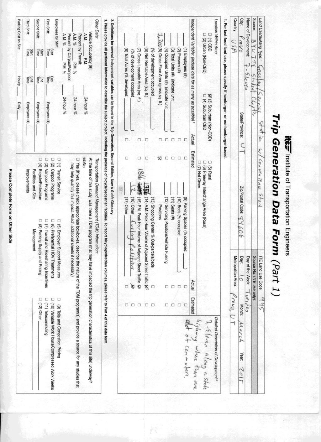
1 Trip Generation Study: A 7-Eleven Gas Station with a Convenience Store Land Use Code: 945 Introduction The Brigham Young University Institute of Transportation Engineers student chapter (BYU ITE) completed a trip generation study, as proposed to the ITE Western District. The data were collected at a 7-Eleven in Provo, Utah. This corresponds to Trip Generation Land Use Code 945 as a convenience store with a gas station. This project was a great learning experience for the student chapter and for those who were involved in the process. Ryan Hales, P.E., PTOE, AICP, of Hales Engineering, provided mentoring support and project review for this data collection effort. Dr. Mitsuru Saito and Dr. Grant Schultz, both of BYU, have provided valuable help and support and data collection equipment for the project. Site Information Data used in the study were collected from March 10-12, An aerial photo of the study location is provided in Figure 1. The blue box represents the where the site is located. The red bars represent the location of the two accesses at the site. The purple circle shows the location of the data collection trailer. Figure 2 shows a closer view of the study site with the accesses along opposite edges of the screen. The 7-Eleven site is located at the northeast corner of 1860 South & State St. (US-89) in Provo, Utah. The site has a convenience store and a gas station, constructed within the past three years. There are two accesses, including a west access and south access that allow traffic to enter and exit the site. The west access is approximately 160 ft. north of the US-89/1860 South intersection on US-89. The South access is located on 1860 South, approximately 60 ft. east of the intersection. The site characteristics are presented in Table 1. 1


2 N Figure 1 Aerial View of Study Location Figure 2 The Study Site 2
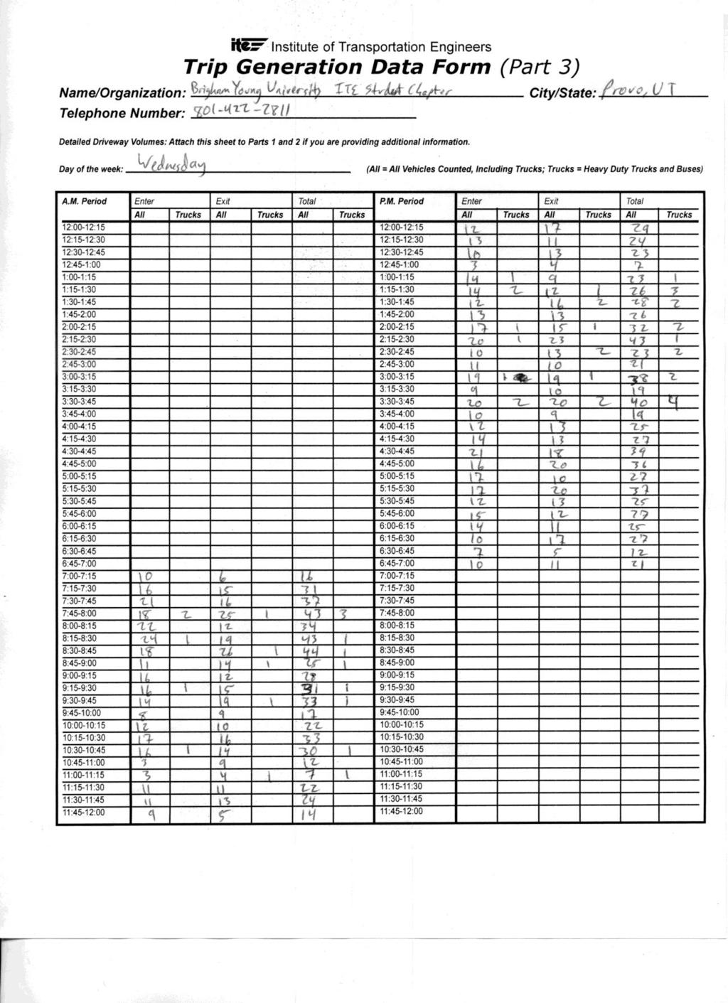
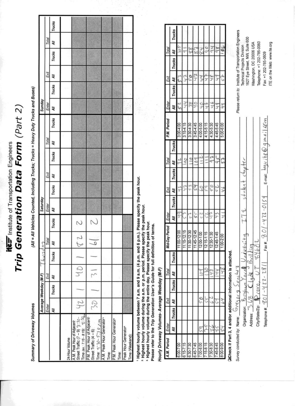
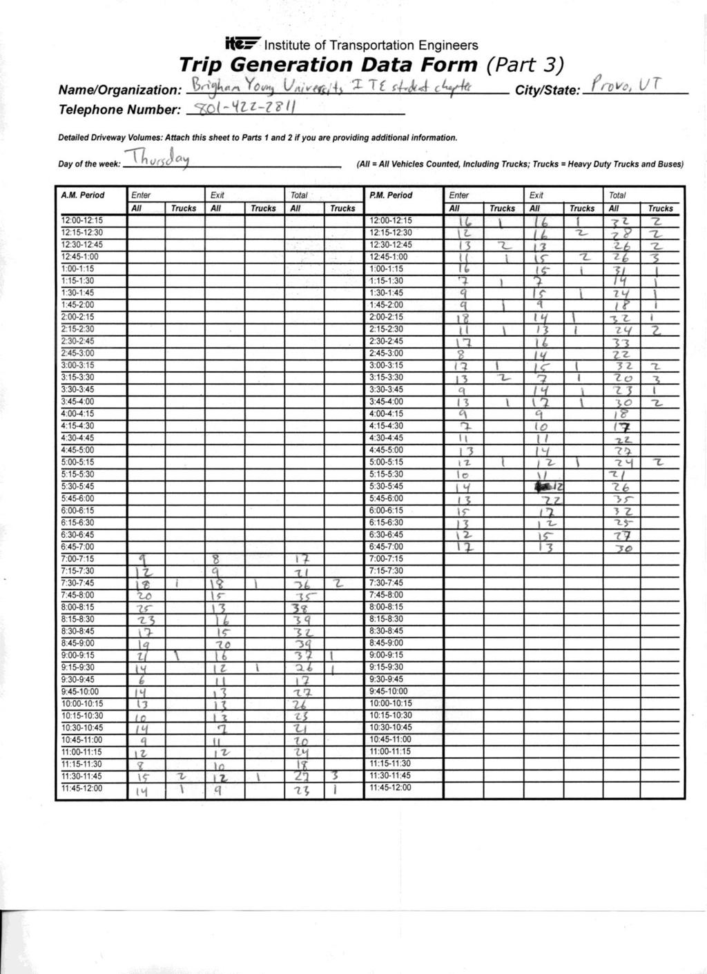
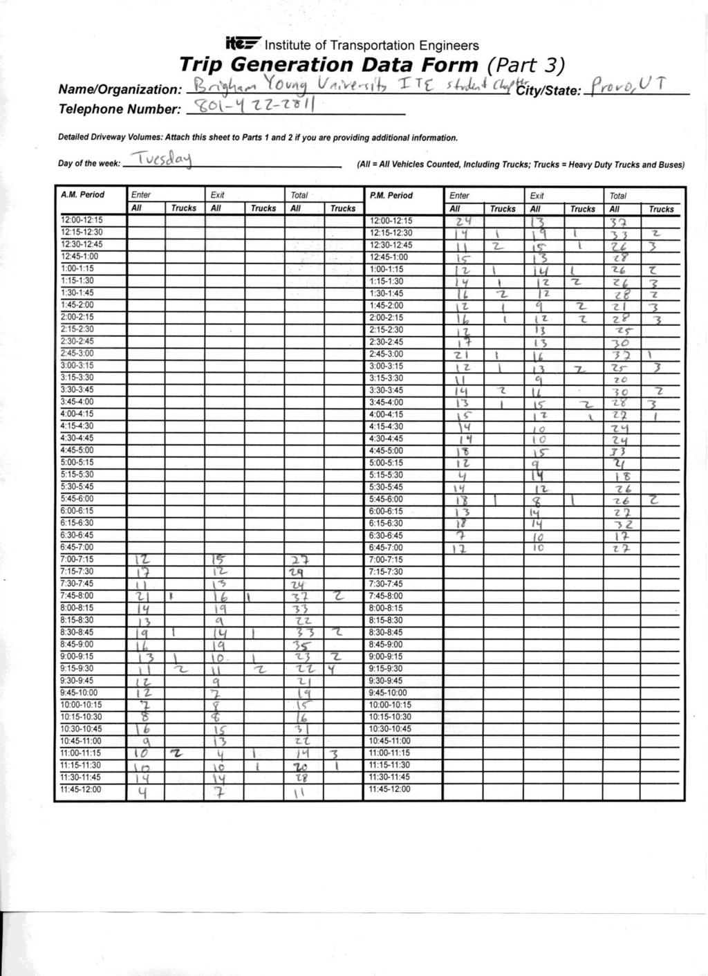
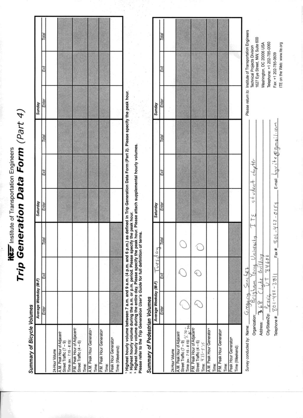
3 Table 1 Site Characteristics Characteristic Value Gross Floor Area (GFA) 3,200 ft 2 No. of Fueling Positions 12 AM Avg. Peak Hour Adjacent Traffic 1,727 PM Avg. Peak Hour Adjacent Traffic 2,073 Methodology Data were collected from Tuesday, March 10, 2015 through Thursday, March 12, 2015, being three consecutive days of data were collected as stated in our proposal. Data collected on these days of the week tend to provide a closer representation of normal weekday. Trip generation was counted between the hours of 7 AM and 7 PM for all three days and adjacent street counts were collected from 7-9 AM and 4-6 PM for all three days. For the study, the BYU Traffic Data Collection Trailer was used to collect data at the site. The trailer is equipped with two video cameras that recorded each access point to the site during the specified hours. The camera which was facing the west access along State St. (US-89) was also used to count adjacent street volumes. The view from the location of the data collection trailer at the site is presented in Figure 3. The recorded videos from the data collection trailer were used to manually count vehicles entering and exiting the site through each access and the volume for the adjacent street using JAMAR counters and a tabular sheet, as shown in Figure 4. The total counts for the two access points were taken for each hour. The results of the trip generation for each of the three days are summarized in the attached Trip Generation Data Forms. 3


4 Figure 3 View from Data Collection Trailer Location Figure 4 Data Reduction from Traffic Trailer Footage 4
5 Results The trip data for the AM peak period and the PM peak period of the days data were collected are shown in Table 2 and Table 3, respectively. The trip rates shown are rates per number of fueling stations, 1000 square feet of gross floor area (sq. ft. GFA), and peak hour traffic on the adjacent street. These rates are also calculated using specifically the data collected during the same day. A summary of trips counted each day of the study along with the entry/exit distribution is presented in Table 4. Table 2 AM Peak Period Trip Data by Day for the Convenience Store w/ Gas Station Variable Tuesday Wednesday Thursday 3/10/2014 3/11/2014 3/12/2014 Peak Hour 7:30-8:30 AM 7:45-8:45 AM 7:30-8:30 AM Total Trips Trip Rate (per fueling station) Trip Rate (per 1,000 sq. ft. GFA) Trip Rate (per AM Peak Hour Traffic on Adjacent Street) % Entering 50.9% 50.0% 58.1% % Exiting 49.1% 50.0% 41.9% Table 3 PM Peak Period Trip Data by Day for the Convenience Store w/ Gas Station Variable Tuesday 3/10/2014 Wednesday 3/11/2014 Thursday 3/12/2014 Peak Hour 5:00-6:00 PM 5:15-6:15 PM 4:30-5:30 PM Total Trips Trip Rate (per fueling station) Trip Rate (per 1,000 sq. ft. GFA) Trip Rate (per PM Peak Hour Traffic on Adjacent Street) % Entering 56.9% 52.6% 48.9% % Exiting 43.1% 47.4% 51.1% 5
6 Table 4 Summary of Daily Trip Data Tuesday (3/10/2015) Wednesday (3/11/2015) Thursday (3/12/2015) Peak Entering Exiting Total Entering Exiting Total Entering Exiting Total AM PM % 49.1% 100.0% 50.0% 50.0% 100.0% 58.1% 41.9% 100.0% % 43.1% 100.0% 52.6% 47.4% 100.0% 48.9% 51.1% 100% The trips generated from this study have been calculated and are shown in Table 5 alongside average trip rates from ITE Trip Generation, 9 th Edition for comparison. Since the ITE trip generation data were based on small samples of similar locations, it is important to create more samples to more accurately predict trip generation rates for future developments. The comparison of the actual counted number of trips in this study and the predicted number of trips based on ITE trip generation rates are presented in Table 6. Table 5 Comparison of Calculated Average Trip Rate and ITE Trip Generation Rates for AM and PM Peak Hours Independent Variable Trip Rate (per fueling station) Trip Rate (per 1,000 sqft. GFA) Trip Rate (per AM/PM Peak Hour Traffic on Adjacent Street) Weekday AM Peak Hour Weekday PM Peak Hour Calculated ITE Calculated ITE
7 Table 6 Comparison of the Average Observed Trips and ITE Predicted Trips for AM and PM Peak Hours Independent Variable Trip Rate (per fueling station) Trip Rate (per 1,000 sqft. GFA) Trip Rate (per AM/PM Peak Hour Traffic on Adjacent Street) Weekday AM Peak Hour Weekday PM Peak Hour Observed Predicted Observed Predicted The number of samples used in creating the ITE Trip Generation rates ranged from 11 to 78. This provides a reasonable sample and also enough to compare the rates. The rates can be observed from Tables 5 and 6 and are somewhat similar to the ITE rates. The most significant differences are in the PM peak hour vs sq. ft. GFA and in PM peak hour vs. fueling stations. Both of these rates are derived from samples of 78 and 54, respectively. An important note is the small sample size of eight used in calculating these sample rates. The data shows the largest difference from the predicted values using the ITE rates was during the PM peak showing that the observed counts were significantly less by 107 trips. The study site is located along the southern border of Provo, near the town of Springville. State Street is a major corridor, connecting the towns along the base of the Wasatch Front Mountain Range. The nature of the location of this site and the adjacent highway might account for the variance between observed and predicted trip generation. The site is not located in a central business district (CBD) or near major residential areas, and thus would be classified as a suburban non-cdb location. Figures 5, 6 and 7 show the hourly variations for entering vehicles, exiting vehicles, and total trips for Tuesday, Wednesday, and Thursday. The total trips to the site by day are summarized in Figure 8. Table 7 compares the directional distribution percentages for these trips by percentage to the percentages provided by ITE. It can be observed that the overall distribution percentages are relatively similar. 7
8 Total Trips Total Trips Hourly Trip Variation on 3/10/ Time of Day (Military Time) Entering Trips Exiting Trips Total Trips Figure 5 Hourly Counts for Tuesday, 3/10/15 Hourly Trip Variation on 3/11/ Time of Day (Military Time) Entering Trips Exiting Trips Total Trips Figure 6 - Hourly Counts for Wednesday, 3/11/15 8
9 Total Trips Total Trips Hourly Trip Variation on 3/12/ Time of Day (Military Time) Entering Trips Exiting Trips Total Trips Figure 7 - Hourly Counts for Thursday, 3/12/15 Total Entering + Exiting Trips to Site Time of Day (Military Time) 3/10/2015 3/11/2015 3/12/2015 Figure 8- Total Trips by Day 9
10 Table 7: Directional Summary Time Direction Actual ITE AM Peak Hour PM Peak Hour Entering 53% 50% Exiting 47% 50% Entering 53% 50% Exiting 47% 50% In this study, it was observed that there were never any long queues of more than two cars at a pump over the course of the data collection period. The high number of fueling positions available for use allowed for the customers to purchase fuel without waiting. There were a few pedestrians and no bicyclists over the course of the data collection period. These observations are presented in the data collection forms. The site is not located within walking distance of any major location or housing communities from which pedestrians would come from and its location along a state highway, which explain its low pedestrian counts. For this reason, the focus of the study was vehicular trips due to the lack of significant pedestrian or bicycle volumes. Conclusion The results from this data collection provide another sample for the ITE Trip Generation data. The calculated trip rates for this sample of data will allow ITE s trip rates to be a better representation of existing conditions. This sample had a large difference in rates regarding trips per fueling stations and trips per 1,000 GSA. However, the trip rates calculated by using AM and PM peak hours did not vary much from ITE s trip generation rates. Adding these rates to the pool of sample sites will allow for a better representation of trips generated by similar sites and will be beneficial to providing accurate traffic impact analyses of future developments as they are created. Level of Effort Approximately 20 different BYU ITE student members were involved in this study. BYU ITE student chapter officers spent numerous hours organizing and carrying out the data collection efforts. A summary of hours spent on the project by student members is shown in Table 8. Table 8: Level of Effort Task Number of Total Students Hours Training & Planning 5 10 Repair & Set-up Equipment 2 5 Data Collection 1 42 Data Reduction Write Report 3 13 Total:
11 Tip Generation Forms 11
12 12
13 13
14 14

15 15
16 16
17 17
18 18

19 19
20 20

21 21
22 22
23 23
24 Parking Demand Survey Form Institute of Transportation Engineers (fill in all highlighted cells - * are required data) Land Use Code* 945 Name of Site 7-Eleven Brief Description of Site Transit* No 7-Eleven Convenience store with Gas Station Area* Suburb non-cbd City Provo TMP* No State Utah Country USA Parking Price* $ - Daily Rate 0 Hourly Rate Site Size* 3,200 Units* Square Feet Occupancy* 100% Site Size 12 Units Fueling Pos. Occupancy Site Size Units Occupancy Site Size Units Occupancy Land Use Number of Parking Spaces Provided at Site 14 Highest Observed Parking Demand for the following hours of the day (hour beginning)* Date 10-Mar Mar Mar-15 Day Tuesday Wednesday Thursday 12 Mid 1:00 AM 2:00 AM 3:00 AM 4:00 AM 5:00 AM 6:00 AM 7:00 AM :00 AM :00 AM :00 AM :00 AM Noon :00 PM :00 PM :00 PM :00 PM :00 PM :00 PM :00 PM 8:00 PM 9:00 PM 10:00 PM 11:00 PM Person Gregory Sanchez Organization BYU ITE Student Chapter Phone Fax byuite@gmail.com Notes Enter data on the w eb at w w w.ite.org IF not entered on w eb site, please mail to: Institute of Transportation Engineers, 1627 Eye Street, NW Suite 600; Washington, DC Comments to: ite_staff@ite.org 24
Trip and Parking Generation Study of Orem Fitness Center-Abstract
 Trip and Parking Generation Study of Orem Fitness Center-Abstract The Brigham Young University Institute of Transportation Engineers student chapter (BYU ITE) completed a trip and parking generation study
2014 Data Collection Project ITE Western District
 2014 Data Collection Project ITE Western District Project Completed By: Oregon State University OSU ITE Student Chapter 101 Kearney Hall Corvallis, OR 97331 Student Coordinator: Sarah McCrea (OSU ITE Student
Trip Generation Characteristics of Super Convenience Market Gasoline Pump Stores
 Trip Generation Characteristics of Super Convenience Market Gasoline Pump Stores This article presents the findings of a study that investigated trip generation characteristics of a particular chain of
California Urban Infill Trip Generation Study. Jim Daisa, P.E.
 California Urban Infill Trip Generation Study Jim Daisa, P.E. What We Did in the Study Develop trip generation rates for land uses in urban areas of California Establish a California urban land use trip
NATHAN HALE HIGH SCHOOL PARKING AND TRAFFIC ANALYSIS. Table of Contents
 Parking and Traffic Analysis Seattle, WA Prepared for: URS Corporation 1501 4th Avenue, Suite 1400 Seattle, WA 98101-1616 Prepared by: Mirai Transportation Planning & Engineering 11410 NE 122nd Way, Suite
MEMORANDUM. The study area of the analysis was discussed with City staff and includes the following intersections:
 MEMORANDUM DATE: JULY 6, 2012 TO: FROM: RE: CC: MELANIE KNIGHT BRAD BYVELDS/ JENNIFER LUONG 1050 SOMERSET STREET PRELIMINARY TRAFFIC ANALYSIS OUR FILE NO. 111152 NEIL MALHOTRA The purpose of this memo
January 12, Mr. Ryan Granger TMGB Wilson, LLC 2221 Health Drive SW, Suite 2200 Wyoming, Michigan 49519
 January 12, 2018 Mr. Ryan Granger TMGB Wilson, LLC 2221 Health Drive SW, Suite 2200 Wyoming, Michigan 49519 Re: Proposed Reserve at Rivertown Mixed-Use Development Updated Trip Generation and Site Driveway
City of Hermosa Beach Beach Access and Parking Study. Submitted by. 600 Wilshire Blvd., Suite 1050 Los Angeles, CA
 City of Hermosa Beach Beach Access and Parking Study Submitted by 600 Wilshire Blvd., Suite 1050 Los Angeles, CA 90017 213.261.3050 January 2015 TABLE OF CONTENTS Introduction to the Beach Access and Parking
Focused Traffic Analysis for the One Lincoln Park Project
 September 15, 2015 Mr. Bill Johnson Coldwell Banker 511 Sir Francis Drake Boulevard Greenbrae, CA 94904 Focused Traffic Analysis for the One Lincoln Park Project Dear Mr. Johnson; As requested, W-Trans
CVS Derwood. Local Area Transportation Review
 CVS Derwood Montgomery County, Maryland May 27, 2016 Local Area Transportation Review Prepared for: JC Bar Properties, Inc. Steve Fleming, PE 415 Fallowfield Road, Suite 301 Camp Hill, Pennsylvania 17011
MADISON, WI STONE HOUSE DEVELOPMENT 1000 E. WASHINGTON AVENUE REDEVELOPMENT TRANSPORTATION STUDY DECEMBER 14, 2015
 MADISON, WI STONE HOUSE DEVELOPMENT 1000 E. WASHINGTON AVENUE REDEVELOPMENT TRANSPORTATION STUDY DECEMBER 14, 2015 TABLE OF CONTENTS... 3 Proposed Development... 3 Methodology... 3 Phase 1 Development...
Traffic Impact Study
 Traffic Impact Study Statham DRI One University Parkway Prepared for: Barrow County Prepared by: October 2012 Table of Contents Executive Summary i Section 1. Introduction 1 Project Description 1 Methodology
HALFF 16196? TRAFFIC MANAGEMENT PLAN. Richardson ISD Aikin Elementary School Dallas, Texas North Bowser Road Richardson, Texas 75081
 30280 16196? TRAFFIC MANAGEMENT PLAN Exhibit 572B Aikin Elementary School Planned Development District No. 572 Approved City Plan Commission October20, 2016 July 12, 2016 Prepared for HALFF AVO 31586 PHO1
Parking Study MAIN ST
 Parking Study This parking study was initiated to help understand parking supply and parking demand within Oneida City Center. The parking study was performed and analyzed by the Madison County Planning
2129 NORTH MAIN STREET HOTE PROJECT ULI SHARED PARKING STUDY City of Santa Ana, California
 2129 NORTH MAIN STREET HOTE PROJECT ULI SHARED PARKING STUDY City of Santa Ana, California Prepared for: NET DEVELOPMENT COMPANY 3130 Airway Avenue Costa Mesa, CA 92626 Prepared by: RK ENGINEERING GROUP,
Encapsulating Urban Traffic Rhythms into Road Networks
 Encapsulating Urban Traffic Rhythms into Road Networks Junjie Wang +, Dong Wei +, Kun He, Hang Gong, Pu Wang * School of Traffic and Transportation Engineering, Central South University, Changsha, Hunan,
Establishment of Local Trip Generation Rates or Equations for Mixed-Use Developments in Kansas
 Report No. K-TRAN: KU-11-7 FINAL REPORT October 2012 Establishment of Local Trip Generation Rates or Equations for Mixed-Use Developments in Kansas Mehrdad Givechi, P.E., PTOE George Sarkodee The University
The Urbana Free Library Parking and Transportation Study
 CHAMPAIGN COUNTY REGIONAL PLANNING COMMISSION The Urbana Free Library Parking and Transportation Study Final Report 7/18/2013 Champaign Urbana Urbanized Area Transportation Study (CUUATS) TABLE OF CONTENTS
MEMORANDUM. Trip Generation Analysis
 MEMORANDUM To: RMC Architects From: Matthew Palmer, PE Subject: Trip Generation, Parking Analysis & Level of Service Project: Port of Everett, GTC #13-053 Date: August 25, 2014 The trip generation and
JEP John E. Jack Pflum, P.E. Consulting Engineering 7541 Hosbrook Road, Cincinnati, OH Telephone:
 JEP John E. Jack Pflum, P.E. Consulting Engineering 7541 Hosbrook Road, Cincinnati, OH 45243 Email: jackpflum1@gmail.com Telephone: 513.919.7814 MEMORANDUM REPORT Traffic Impact Analysis Proposed Soccer
Unit 1, Lesson 3 What Tools and Technologies Do Geographers Use?
 Unit 1, Lesson 3 What Tools and Technologies Do Geographers Use? Geographers use a variety of tools and technologies in investigating geographic questions. Maps and globes both represent the earth, but
WEBER ROAD RESIDENTIAL DEVELOPMENT Single Family Residential Project
 WEBER ROAD RESIDENTIAL DEVELOPMENT Single Family Residential Project WEBER ROAD RESIDENTIAL DEVELOPMENT TRAFFIC IMPACT STUDY TABLE OF CONTENTS 1.0 Executive Summary Page 2.0 Introduction 2.1 DEVELOPMENT
April 10, Mr. Curt Van De Walle, City Manager City of Castle Hills 209 Lemonwood Drive Castle Hills, Texas 78213
 Mr. Curt Van De Walle, City Manager City of Castle Hills 209 Lemonwood Drive Castle Hills, Texas 78213 Subject: Revised Castle Hills BASIS Charter School Traffic Impact Analysis Review City of Castle Hills,
TEEN DRIVER ELECTRONIC DEVICE OBSERVATION FORM
 TEEN OBSERVATION FORM High Schools will count only teen drivers. If your school does not have many teen drivers, please use the Junior High form to count adult drivers. Choose a day to conduct your pre-observations.
930 Old Northern Rd & 4 Post Office Rd, Glenorie
 Proposed Mixed Use Development 930 Old Northern & 4, Glenorie TRAFFIC AND PARKING ASSESSMENT REPORT 13 December 2016 Ref 16264 Suite 6, 20 Young Street, Neutral Bay NSW 2089 - PO Box 1868, Neutral Bay
Unit 1, Lesson 2. What is geographic inquiry?
 What is geographic inquiry? Unit 1, Lesson 2 Understanding the way in which social scientists investigate problems will help you conduct your own investigations about problems or issues facing your community
2011 South Western Region Travel Time Monitoring Program Congestion Management Process. Executive Summary
 2011 South Western Region Travel Monitoring Program Executive Summary Prepared by: South Western Regional Planning Agency 888 Washington Blvd, 3rd Floor Stamford, CT 06901 Telephone: 203.6.5190 Facsimile:
Morgantown, West Virginia. Adaptive Control Evaluation, Deployment, & Management. Andrew P. Nichols, PhD, PE
 Morgantown, West Virginia Adaptive Control Evaluation, Deployment, & Management Andrew P. Nichols, PhD, PE Program Director of ITS Nick J. Rahall II, Appalachian Transportation Inst. Marshall University
The Sunland Park flyover ramp is set to close the week of March 19 until early summer
 March 2, 2018 The Sunland Park flyover ramp is set to close the week of March 19 until early summer GO 10 is targeting the week of March 19 to close the Sunland Park Drive flyover entrance ramp to I 10
UNIVERSITY OF CAMBRIDGE INTERNATIONAL EXAMINATIONS International General Certificate of Secondary Education
 UNIVERSITY OF CAMBRIDGE INTERNATIONAL EXAMINATIONS International General Certificate of Secondary Education *6894851605* GEOGRAPHY 0460/42 Paper 4 Alternative to Coursework October/November 2012 1 hour
Border Crossing Freight Delay Data Collection and Analysis World Trade Bridge Laredo International Bridge 4 Laredo, Texas
 Border Crossing Freight Delay Data Collection and Analysis World Trade Bridge Laredo International Bridge 4 Laredo, Texas The border crossing freight delay data collection and analysis project was conducted
Appendix C Final Methods and Assumptions for Forecasting Traffic Volumes
 Fairview Ave. and Main St. Improvements and Local Streets Plan Appendices Ada County Highway District Appendix C Final Methods and Assumptions for Forecasting Traffic Volumes January 3, 207 Appendices
TEEN DRIVER SEAT BELT OBSERVATION FORM
 TEEN DRIVER SEAT BELT OBSERVATION FORM High Schools will count only teen drivers and passengers. If the vehicle is being driven by an adult, only count teen passengers. DO NOT notify students that counts
Speed Limit Review. Montague Road, West End. Prepared for Brisbane City Council CEB06842 CEB06842
 Speed Limit Review Montague Road, West End CEB06842 CEB06842 Prepared for Brisbane City Council 2 November 2016 Speed Limit Review Montague Road, West End Document Information Prepared for Brisbane City
ASTR 101L: Motion of the Sun Take Home Lab
 Name: CWID: Section: Introduction Objectives This lab is designed to help you understand the Sun s apparent motion in the sky over the course of the year. In Section 2 you are asked to answer some questions
Density and Walkable Communities
 Density and Walkable Communities Reid Ewing Professor & Chair City and Metropolitan Planning University of Utah ewing@arch.utah.edu Department of City & Metropolitan Planning, University of Utah MRC Research
Honorable Mayor and Members of the City Council
 TO: ATTENTION: FROM: SUBJECT: Honorable Mayor and Members of the City Council Jeffrey L. Stewart, City Manager Len Gorecki, Director of Public Works Jerry Stock, City Engineer Public Hearing to Consider
Accessing and Using Indiana Traffic Data
 Accessing and Using Indiana Traffic Data Purdue Road School March 6, 2013 Presented by: Gregory Katter, PE Asset Planning Indiana Traffic Data 1. Overview of Traffic Data Collection Program 2. Accessing
Non-Motorized Traffic Exploratory Analysis
 Non-Motorized Traffic Exploratory Analysis --------------------------------------------------------------- Chao Wu Advisor: Professor Greg Lindsey Humphrey School of Public Affairs University of Minnesota
Market Street PDP. Nassau County, Florida. Transportation Impact Analysis. VHB/Vanasse Hangen Brustlin, Inc. Nassau County Growth Management
 Transportation Impact Analysis Market Street PDP Nassau County, Florida Submitted to Nassau County Growth Management Prepared for TerraPointe Services, Inc. Prepared by VHB/Vanasse Hangen Brustlin, Inc.
ACCESSIBILITY OF INTERMODAL CENTERS STUDY
 ACCESSIBILITY OF INTERMODAL CENTERS STUDY Presentation for VDOT Forum - Coordinating Transportation Planning and Land Use Wednesday, April 2, 2014 Vlad Gavrilovic, AICP - Renaissance Planning Group Tasks
VHD Daily Totals. Population 14.5% change. VMT Daily Totals Suffolk 24-hour VMT. 49.3% change. 14.4% change VMT
 6.9 Suffolk 6-54 VMT Population and Travel Characteristics Population 14.5% change 2014 1,529,202 VHD Daily Totals 2014 251,060 49.3% change 2040 1,788,175 2040 374,850 VMT Daily Totals 2014 39,731,990
225 Bush Street Suite 1700 San Francisco, CA phone fax
 225 Bush Street Suite 1700 San Francisco, CA 94104 415.896.5900 phone 415.896.0332 fax www.esassoc.com memorandum date July 29, 2009 to from subject Craig Nikitas, San Francisco Planning Department Daniel
6711 LEE HIGHWAY TRAFFIC IMPACT STUDY ARLINGTON, VIRGINIA
 6711 TRAFFIC IMPACT STUDY ARLINGTON, VIRGINIA Prepared for: NVR, Inc. Prepared by: Wells + Associates, Inc. Michael J. Workosky, PTP, TOPS, TSOS John J. Andrus William L. Zeid, PE 703.917.6620 May 4, 2017
ALTA VISTA COMMERCIAL/ RESIDENTIAL PROJECT
 ALTA VISTA COMMERCIAL/ RESIDENTIAL PROJECT TRAFFIC IMPACT ANALYSIS Prepared For: Paul Conzelman SC Development 2151 Michelson Drive, Suite 140 Irvine, CA 92612 Prepared By: 2030 Main Street, Suite 1200
Town of Davie B-2 (Community Business) Zoning:
 Zoning:") Town of Davie B-2 (Community Business) Zoning: Commercial Conservation Districts: These districts are intended to preserve the character of existing nonresidential or commercial areas, neighborhoods and
Town of Davie B-2 (Community Business) Zoning: Commercial Conservation Districts: These districts are intended to preserve the character of existing nonresidential or commercial areas, neighborhoods and
Montmorency County Traffic Crash Data & Year Trends. Reporting Criteria
 June 2018 Revised 8/3/2018 2017 Reporting Criteria Please pay particular attention to the wording when interpreting the three levels of data gathered for this report. Crash The Crash Level analyzes data
Montmorency County Traffic Crash Data & Year Trends. Reporting Criteria
 June 2017 Revised 10/3/17 2016 Reporting Criteria Please pay particular attention to the wording when interpreting the three levels of data gathered for this report. Crash The Crash Level analyzes data
Six (6) Unit Apartment Building Along Garfield Boulevard - Bank Owned WEST GARFIELD BOULEVARD CHICAGO, IL DETAILS PROPERTY OVERVIEW
 Unit Apartment Building Along Garfield Boulevard - Bank Owned WEST GARFIELD BOULEVARD CHICAGO, IL DETAILS PROPERTY OVERVIEW") 907-909 WEST GARFIELD BOULEVARD CHICAGO, IL 60621 DETAILS Sale Price $370,000 Lot Size 7,500 SF Building Size 8,538 SF Taxes (2016) $6,021.31 Zoning R-1, Low Density Residential Market South Chicago Cross
907-909 WEST GARFIELD BOULEVARD CHICAGO, IL 60621 DETAILS Sale Price $370,000 Lot Size 7,500 SF Building Size 8,538 SF Taxes (2016) $6,021.31 Zoning R-1, Low Density Residential Market South Chicago Cross
Travel Demand Management Plan
 Travel Demand Management Plan Tryg s & Apartment Building 8 West Lake Street Minneapolis, MN AUTHORIZED PROPERTY REPRESENTATIVE: By Dated: Mr. Johnny Carlson Trammell Crow Chicago Development, Inc. 5 South
Date: April 3, 2018 Revised May 15, Project #: Re: Burlington Mall Retail Collection Transportation Evaluation
 To: Chuck Schneider Burlington S&S, LLC 225 West Washington Street Indianapolis, IN 46204 From: Patrick Dunford, P.E. Senior Project Manager Date: April 3, 2018 Revised May 15, 2018 Project #: 13482.01
WOODRUFF ROAD CORRIDOR ORIGIN-DESTINATION ANALYSIS
 2018 WOODRUFF ROAD CORRIDOR ORIGIN-DESTINATION ANALYSIS Introduction Woodruff Road is the main road to and through the commercial area in Greenville, South Carolina. Businesses along the corridor have
of places Key stage 1 Key stage 2 describe places
 Unit 25 Geography and numbers ABOUT THE UNIT This continuous unit aims to show how geographical enquiry can provide a meaningful context for the teaching and reinforcement of many aspects of the framework
CHAPTER 3. CAPACITY OF SIGNALIZED INTERSECTIONS
 CHAPTER 3. CAPACITY OF SIGNALIZED INTERSECTIONS 1. Overview In this chapter we explore the models on which the HCM capacity analysis method for signalized intersections are based. While the method has
Prepared for: San Diego Association Of Governments 401 B Street, Suite 800 San Diego, California 92101
 Activity-Based Travel Model Validation for 2012 Using Series 13 Data: Coordinated Travel Regional Activity Based Modeling Platform (CT-RAMP) for San Diego County Prepared for: San Diego Association Of
APPENDIX I: Traffic Forecasting Model and Assumptions
 APPENDIX I: Traffic Forecasting Model and Assumptions Appendix I reports on the assumptions and traffic model specifications that were developed to support the Reaffirmation of the 2040 Long Range Plan.
Appendixx C Travel Demand Model Development and Forecasting Lubbock Outer Route Study June 2014
 Appendix C Travel Demand Model Development and Forecasting Lubbock Outer Route Study June 2014 CONTENTS List of Figures-... 3 List of Tables... 4 Introduction... 1 Application of the Lubbock Travel Demand
Logistical and Transportation Planning. QUIZ 1 Solutions
 QUIZ 1 Solutions Problem 1. Patrolling Police Car. A patrolling police car is assigned to the rectangular sector shown in the figure. The sector is bounded on all four sides by a roadway that requires
I. M. Schoeman North West University, South Africa. Abstract
 Urban Transport XX 607 Land use and transportation integration within the greater area of the North West University (Potchefstroom Campus), South Africa: problems, prospects and solutions I. M. Schoeman
River Realty Services Commercial
 1 4 6 N O R T H U S 9 W, C O N G E R S, N Y 1 0 9 2 0 TA B L E O F C O N T E N T S E X E C U T I V E S U M M A RY 03 Z O N I N G 09 R EG I S T R AT I O N S 04 S U B J EC T P H OTO S 10 M A P V I E W 05
RE: Existing and Future Parking Demand Analysis St. Joseph Center Expansion
 HAND DELIVERED December 12, 2003 Mr. James S. Bancroft Chair, Board of Directors St. Joseph Center 204 Hampton Drive Venice, California 90291-8633 RE: Existing and Future Parking Demand Analysis St. Joseph
ADAPTIVE SIGNAL CONTROL IV
 ADAPTIVE SIGNAL CONTROL IV Evaluation of the Adaptive Traffic Control System in Park City, Utah Dr. Peter T. Martin Associate Professor Aleksandar Stevanovic Research Associate Ivana Vladisavljevic Research
Project Appraisal Guidelines
 Project Appraisal Guidelines Unit 16.2 Expansion Factors for Short Period Traffic Counts August 2012 Project Appraisal Guidelines Unit 16.2 Expansion Factors for Short Period Traffic Counts Version Date
Winning Farm of Winchester
 Winning Farm of Winchester Planning Board Presentation Winning Farm of Winchester 12.9 acres of undeveloped forest on the former Winning Farm site Located north of Thornberry Road in the northwestern corner
US 169/I-70 North Loop Planning & Environmental Linkages Study
 US 169/I-70 North Loop Planning & Environmental Linkages Study VISSIM Calibration Document Draft April 13, 2018 Page i Table of Contents 1. Overview... 1 2. Data Types... 2 3. Model Parameter Adjustments...
KEY: R-1 Low Density Residential. R-2 Medium Density Residential. R-3 High Density Residential. S-C Service Commercial. D-C Downtown Commercial
 KEY: R-1 Low Density Residential R-2 Medium Density Residential R-3 High Density Residential S-C Service Commercial D-C Downtown Commercial M-C Medical Commercial H-I Heavy Industrial PARKING MATRIX A
Social Studies Grade 2 - Building a Society
 Social Studies Grade 2 - Building a Society Description The second grade curriculum provides students with a broad view of the political units around them, specifically their town, state, and country.
Cipra D. Revised Submittal 1
 Cipra D. Revised Submittal 1 Enhancing MPO Travel Models with Statewide Model Inputs: An Application from Wisconsin David Cipra, PhD * Wisconsin Department of Transportation PO Box 7913 Madison, Wisconsin
Appendix BAL Baltimore, Maryland 2003 Annual Report on Freeway Mobility and Reliability
 (http://mobility.tamu.edu/mmp) Office of Operations, Federal Highway Administration Appendix BAL Baltimore, Maryland 2003 Annual Report on Freeway Mobility and Reliability This report is a supplement to:
Automated Delay Estimation at Signalized Intersections: Phase I Concept and Algorithm Development
 Brigham Young University BYU ScholarsArchive All Theses and Dissertations 2011-03-16 Automated Delay Estimation at Signalized Intersections: Phase I Concept and Algorithm Development Taylor R. Forbush
FDOT Level 2 Roundabout b/c Evaluation
 FDOT Level 2 Roundabout b/c Evaluation This spreadsheet tool compares the cost of a roundabout to the cost of a traditional intersection, as specified by the user. A traditional intersection is defined
REO 100% Leased Four (4) Unit Mixed-Use Property Along Ashland
 Unit Mixed-Use Property Along Ashland") 5015 SOUTH ASHLAND AVENUE CHICAGO, IL 60609 DETAILS Sale Price $119,000 Lot Size 0.06 Acres Building Size 3,784 SF Occupancy 100% Year Built 1893 Market Cook County Sub Market South Chicago Cross Streets
5015 SOUTH ASHLAND AVENUE CHICAGO, IL 60609 DETAILS Sale Price $119,000 Lot Size 0.06 Acres Building Size 3,784 SF Occupancy 100% Year Built 1893 Market Cook County Sub Market South Chicago Cross Streets
NAME: DATE: Leaving Certificate GEOGRAPHY: Maps and aerial photographs. Maps and Aerial Photographs
 NAME: DATE: Leaving Certificate Geography Maps and Aerial Photographs Please see Teachers Notes for explanations, additional activities, and tips and suggestions. Learning Support Vocabulary, key terms
FINAL REPORT. City of Toronto. Contract Project No: B
 City of Toronto SAFETY IMPACTS AND REGULATIONS OF ELECTRONIC STATIC ROADSIDE ADVERTISING SIGNS TECHNICAL MEMORANDUM #2B BEFORE/AFTER COLLISION ANALYSIS AT MID-BLOCK LOCATIONS FINAL REPORT 3027 Harvester
Figure 8.2a Variation of suburban character, transit access and pedestrian accessibility by TAZ label in the study area
 Figure 8.2a Variation of suburban character, transit access and pedestrian accessibility by TAZ label in the study area Figure 8.2b Variation of suburban character, commercial residential balance and mix
Greater Toronto Area Cordon Count Summary Analysis of Traffic Trends 1985 to 2011
 Greater Toronto Area Cordon Count Summary Analysis of Traffic Trends 1985 to 2011 Prepared by: Data Management Group Department of Civil Engineering University of Toronto Telephone: (416) 978-3916 Table
One person killed when tornadoes hit Oklahoma, Arkansas (Update) 25 March 2015, byjustin Juozapavicius
 25 March 2015, byjustin Juozapavicius") One person killed when tornadoes hit Oklahoma, Arkansas (Update) 25 March 2015, byjustin Juozapavicius from those. A small tornado swept across parts of Moore, an Oklahoma City suburb where 24 people died
One person killed when tornadoes hit Oklahoma, Arkansas (Update) 25 March 2015, byjustin Juozapavicius from those. A small tornado swept across parts of Moore, an Oklahoma City suburb where 24 people died
SNOW REMOVAL - REQUEST FOR PROPOSAL. Snow Removal/Clearing and Sanding/Salting for Winter Fundy Ocean Research Center for Energy
 Fundy Ocean Research Center for Energy SNOW REMOVAL - REQUEST FOR PROPOSAL Snow Removal/Clearing and Sanding/Salting for Winter 2016-17 Sites 1. FORCE Sub-Station Driveway (portion of Old Black Rock Road),
Parking Regulations Dundas Street West, from Bathurst Street to Dovercourt Road
 STAFF REPORT ACTION REQUIRED Parking Regulations Dundas Street West, from Bathurst Street to Dovercourt Road Date: October 28, 2008 To: From: Toronto and East York Community Council Director, Transportation
AGENDA CLAYTON BOARD OF ADJUSTMENT
 AGENDA CLAYTON BOARD OF ADJUSTMENT APRIL 15, 2015 6:00 P.M. CLAYTON TOWN HALL 111 East Second Street, Clayton NC I. ROLL CALL II. III. IV. ANNOUNCEMENT OF QUORUM / VOTING MEMBERS ADJUSTMENTS TO AGENDA
DOWNTOWN SUB-AREA. Final Parking Study. Prepared for: City of Bellingham. March Prepared by:
 Final Parking Study DOWNTOWN SUB-AREA Prepared for: City of Bellingham March 2013 Prepared by: 11730 118 th Avenue NE, Suite 600 Kirkland, WA 98034-7120 Phone: 425-821-3665 Fax: 425-825-8434 www.transpogroup.com
Topographic Maps Lab
 Geoscience 190 Environmental Geoscience Topographic Maps Lab To represent mountain belts and landforms, geologists work extensively with maps. A very important type of map used for scientific, engineering,
PATREC PERSPECTIVES Sensing Technology Innovations for Tracking Congestion
 PATREC PERSPECTIVES Sensing Technology Innovations for Tracking Congestion Drivers have increasingly been using inexpensive mapping applications imbedded into mobile devices (like Google Maps, MapFactor,
Cambridge International Examinations Cambridge International General Certificate of Secondary Education
 Cambridge International Examinations Cambridge International General Certificate of Secondary Education *86769654* GEOGRAPHY 46/4 Paper 4 Alternative to Coursework May/June 4 Candidates answer on the Question
C) Discuss two factors that are contributing to the rapid geographical shifts in urbanization on a global scale.
 Discuss two factors that are contributing to the rapid geographical shifts in urbanization on a global scale.") AP Human Geography Unit VII. Cities and Urban Land Use Free Response Questions FRQ 1 Rapid urbanization in Least Developed Countries (LDCs) has many profound impacts for the world. Answer the following
AP Human Geography Unit VII. Cities and Urban Land Use Free Response Questions FRQ 1 Rapid urbanization in Least Developed Countries (LDCs) has many profound impacts for the world. Answer the following
Attachment E: CADP Design Shadow Analysis
 Attachment E: CADP Design Shadow Analysis June 6, 2016 TO: Don Lewis San Francisco Planning Department 1650 Mission Street, Suite 400 San Francisco, CA 94103 SUBJECT: 2060 Folsom Street 17 th & Folsom
MEI STRUCTURED MATHEMATICS 4767
 OXFORD CAMBRIDGE AND RSA EXAMINATIONS Advanced Subsidiary General Certificate of Education Advanced General Certificate of Education MEI STRUCTURED MATHEMATICS 4767 Statistics 2 Thursday 9 JUNE 2005 Morning
CAMPUS SNOW REMOVAL DARRIN BEAR EDSON AND CREW
 CAMPUS SNOW REMOVAL DARRIN BEAR EDSON AND CREW Meet the team: NIGHT EQUIPMENT CREW: NATHAN LEAD OPERATOR CASEY OPERATOR JOSHUA OPERATOR DAY EQUIPMENT CREW: IAN LEAD OPERATOR JAMIE OPERATOR TERRY OPERATOR
Appendix E FTA NOISE MODELING WORKSHEETS AND DETAILED METHODOLOGY
 Appendix E FTA NOISE MODELING WORKSHEETS AND DETAILED METHODOLOGY APPENDIX E General Noise Assessment The FTA General Noise Assessment procedure was used for calculating noise from transit sources associated
Employment Decentralization and Commuting in U.S. Metropolitan Areas. Symposium on the Work of Leon Moses
 Employment Decentralization and Commuting in U.S. Metropolitan Areas Alex Anas Professor of Economics University at Buffalo Symposium on the Work of Leon Moses February 7, 2014 9:30-11:15am, and 2:30-4:30pm
STATISTICAL ANALYSIS OF LAW ENFORCEMENT SURVEILLANCE IMPACT ON SAMPLE CONSTRUCTION ZONES IN MISSISSIPPI (Part 1: DESCRIPTIVE)
") STATISTICAL ANALYSIS OF LAW ENFORCEMENT SURVEILLANCE IMPACT ON SAMPLE CONSTRUCTION ZONES IN MISSISSIPPI (Part 1: DESCRIPTIVE) Tulio Sulbaran, Ph.D 1, David Marchman 2 Abstract It is estimated that every
STATISTICAL ANALYSIS OF LAW ENFORCEMENT SURVEILLANCE IMPACT ON SAMPLE CONSTRUCTION ZONES IN MISSISSIPPI (Part 1: DESCRIPTIVE) Tulio Sulbaran, Ph.D 1, David Marchman 2 Abstract It is estimated that every
WCTR-SIG1 (Special Interest Group on Transport and Spatial Development) Draft. Please do not quote. Paper presented at WCTR-SIG1 (Special Interest Gro
 Draft. Please do not quote. Paper presented at WCTR-SIG1 (Special Interest Gro") Draft. Please do not quote. Paper presented at 26,May 2003,Sendai, JAPAN DEVELOPING DRAMATIZING METHOD AS A TOOL FOR EVALUATION OF QUALITY OF LIFE IN CITIES Noriyasu KACHI*, Yukihiko YASUE, Hirokazu KATO,
Draft. Please do not quote. Paper presented at 26,May 2003,Sendai, JAPAN DEVELOPING DRAMATIZING METHOD AS A TOOL FOR EVALUATION OF QUALITY OF LIFE IN CITIES Noriyasu KACHI*, Yukihiko YASUE, Hirokazu KATO,
FINAL Traffic Report for the Proposed Golden Valley Road and Newhall Ranch Road Projects in the City of Santa Clarita, California May 5, 2005
 FINAL Traffic Report for the Proposed Golden Valley Road and Newhall Ranch Road Projects in the City of Santa Clarita, California May 5, 2005 Prepared For: EDAW, Inc. 1420 Kettner Boulevard, Suite 620
IN THE SUPREME COURT OF BELIZE, A.D KIRK HALL BOWEN & BOWEN LTD.
 IN THE SUPREME COURT OF BELIZE, A.D. 2006 CLAIM NO. 415 STACEY COLLINS CLAIMANT BETWEEN AND KIRK HALL BOWEN & BOWEN LTD. 1 st DEFENDANT 2 nd DEFENDANT Hearings 2009 28 th July 4 th September 18 th September
FIND PLACES ON GLOBES USING LATITUDE
 GLOBES, MAPS & GRAPHS FIND PLACES ON GLOBES USING LATITUDE AND LONGITUDE LINES FIND PLACES ON MAPS USING A GRID SYSTEM NAME SEVERAL TYPES OF MAP PROJECTIONS AND EXPLAIN THEIR BENEFITS AND SHORTCOMINGS
TAKE ROLL CALL TO DETERMINE IF THERE IS A QUORUM OF MEMBERS PRESENT
 LAWRENCE SIGN CODE BOARD OF APPEALS AGENDA JULY 5, 2018 6:35 P.M., CITY COMMISSION MEETING ROOM, FIRST FLOOR OF CITY HALL, SIXTH AND MASSACHUSETTS STREET, LAWRENCE, KANSAS CALL THE MEETING TO ORDER TAKE
Developing the Transit Demand Index (TDI) Gregory Newmark, Regional Transportation Authority Transport Chicago Presentation July 25, 2012
 Gregory Newmark, Regional Transportation Authority Transport Chicago Presentation July 25, 2012") Developing the Transit Demand Index (TDI) Gregory Newmark, Regional Transportation Authority Transport Chicago Presentation July 25, 2012 Outline Present RTA methodology Transit Demand Index (TDI) Demonstrate
Developing the Transit Demand Index (TDI) Gregory Newmark, Regional Transportation Authority Transport Chicago Presentation July 25, 2012 Outline Present RTA methodology Transit Demand Index (TDI) Demonstrate
SHADOW STUDY REPORT REGARDING
 SHADOW STUDY REPORT REGARDING an APPLICATION TO REDEVELOP Three 6 Storey Condominiums Regional Road 25 (Ontario Street) and Britannia Road Milton, Ontario KNYMH FILE # 17030 Prepared by: Krista Lilley
March 14 th March 18 th
 March 14 th March 18 th Unit 8: Linear Functions Jump Start Using your own words, what is the question asking? Explain a strategy you ve learned this year to solve this problem. Solve the problem! 1 Scatter
CE351 Transportation Systems: Planning and Design
 CE351 Transportation Systems: Planning and Design TOPIC: Level of Service (LOS) at Traffic Signals 1 Course Outline Introduction to Transportation Highway Users and their Performance Geometric Design Pavement