NATHAN HALE HIGH SCHOOL PARKING AND TRAFFIC ANALYSIS. Table of Contents
|
|
|
- Branden Glenn
- 5 years ago
- Views:
Transcription
1 Parking and Traffic Analysis Seattle, WA Prepared for: URS Corporation th Avenue, Suite 1400 Seattle, WA Prepared by: Mirai Transportation Planning & Engineering NE 122nd Way, Suite 320 Kirkland, WA 98034
2 Table of Contents Executive Summary... 1 Introduction... 3 Existing Conditions... 3 Traffic Conditions... 3 Level of Service Traffic Operations... 4 Level of Service Traffic Operations... 5 Existing Level of Service... 5 Parking Supply... 6 Parking Demand Summer Conditions... 8 Parking Demand School Conditions Future Conditions: Impact of the Proposed Project Analysis Assumptions Analysis Assumptions Future Traffic Conditions Future Level of Service Parking Demand Future Conditions Potential Mitigation List of Tables Table 1. Summary of Proposed Parking Supply...1 Table 2. Summary of Parking Demand...2 Table 3. Summary of Peak Hour and Daily Traffic Conditions...2 Table 4. Level of Service Definitions...5 Table 5. Existing (2007) LOS Results (School Year)...6 Table 6. Summary of Changes to Parking Areas...12 Table 7. Estimate of Future Peak Hour Trips Generated for 1,400 Students...14 Table 8. Intersection Level of Service with Proposed Project...16 Table 9. Estimate of Future Parking Demand and Supply at 1,400 Students...17 Page i
3 List of Figures Figure 1. Existing Traffic Volumes...4 Figure 2. Parking Supply at and Vicinity...7 Figure 3. Summer Parking Utilization...9 Figure 4. School Year Parking Utilization...11 Page ii
4 EXECUTIVE SUMMARY Mirai Transportation Planning and Engineering reviewed the parking and traffic impacts associated with the planned increase of the student population from 1,125 to 1,400 Nathan Hale High School. The following highlights the major findings of the study. Parking Supply The proposed project site plan would change the number of parking spaces within the school s main parking areas. Table 1 summarizes the proposed parking supply. The proposed project would provide 292 parking spaces on-campus, a net increase of 8 spaces. Currently there are approximately 284 parking spaces. In some parking areas, such as near the athletic fields, parking is poorly defined and was estimated. The proposed project would better define parking areas and provide additional parking to accommodate the increased student population. Table 1. Summary of Proposed Parking Supply Existing Proposed Change Main Parking Area Northwest Parking Area Athletic Fields Parking Area Maintenance Parking Area Total School Parking Parking Demand is planning for a future increase from 1,125 to 1,400 students. The following summarizes the impact of the additional students on parking demand. Table 2 summarizes the parking demand for a typical school day. With the increase in students from 1,125 to 1,400 the typical school parking demand would increase by 77 spaces to 289 spaces. Compared to the proposed supply, there would be a 3 space surplus. Page 1
5 Table 2. Summary of Parking Demand Existing (1125 Students) Proposed (1400 Students) Change School Day Parking Demand School Day Capacity School Day Surplus/Deficit Peak Hour Traffic Nathan High School s student population increase from 1,125 to 1,400 students in the future will increase the number of vehicles entering and exiting the school site during peak times. The following summarizes the impact of the additional students on the school driveways and intersections during the school s afternoon peak hour. Table 3 summarizes the total, entering and exiting trips during the peak hour of a typical school day (2:45 PM to 3:45 PM). Estimated daily trips are also reported. The total new trips generated by the increase in student population would be 77 during the PM peak hour and 470 daily. Traffic at adjacent study intersections, other than the student driveway, would continue to operate at acceptable conditions (LOS B or better) during the school s peak hour with the 1,400 student population. Under existing conditions, the main student access on 30th Avenue NE (west student driveway) currently operates at LOS E during the afternoon peak hour. Based on observations and traffic count data, this condition exists for 15 to 20 minutes. With the student population increase, the main student access on 30th Avenue NE, would operate at LOS F during the afternoon peak hour. It is expected that this condition would occur primarily during a 15 to 20 minute period following the school s dismissal. Creation of a left turn lane for vehicles exiting the main student access would improve the intersection s operation from LOS F to LOS D during the peak hour. Table 3. Summary of Peak Hour and Daily Traffic Conditions Existing (1125 Students) Proposed (1400 Students) Change Peak Hour Trips Entering Trips Exiting Trips Daily Trips 1,924 2, Page 2
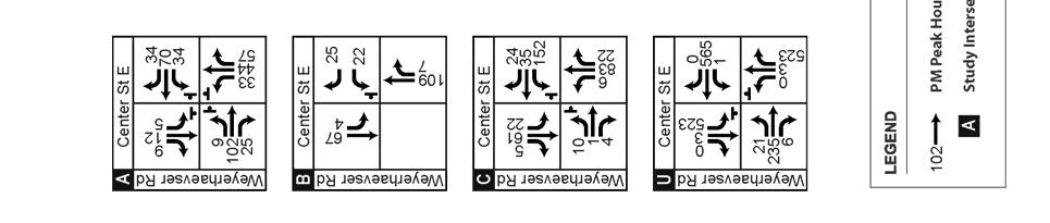
6 Parking and Traffic Impact Analysis INTRODUCTION Mirai Transportation Planning and Engineering reviewed the parking and traffic impacts associated with the modernization of the and the planned increase of the student population from 1,125 to 1,400. Mirai reviewed existing conditions and estimated the future impacts with proposed improvements. This project provides a supplement of previous analysis completed for the Building Excellence (BEX) II Draft and Final EIS. EXISTING CONDITIONS Mirai documented the existing traffic and parking conditions to understand the high school s impact on the surrounding street system and neighborhoods. Traffic counts were conducted at area intersections and school driveways during the school year. Parking data were collected prior to and after the beginning of the school year to identify differences in area parking demand. Traffic Conditions Traffic counts were collected by TC2.com, on Tuesday, September 18, This was a latestart day, with the final period ending at 3 pm. All traffic counts were conducted between 2 and 4 pm to capture the peak period of school activity. Traffic counts were collected at three locations: NE 110th Street/30th Avenue NE Northwest Driveway/30th Avenue NE NE 107th Street/30th Avenue NE (Driveway access) Of the driveways measured, nearly 320 trips were recorded either entering or exiting the site during the peak hour. The primary movement out of the driveways is to the south on 30th Avenue NE with about two-thirds of the exiting volumes (174 out of 258 trips). The south leg of NE 110th Street/30th Avenue NE is a major pedestrian corridor with more than 70 pedestrians crossing during a one-hour period. Figure 1 shows the traffic and pedestrian volumes during the school s afternoon peak hour. Page 3


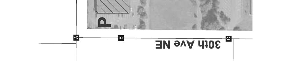
7 Figure 1. Existing Traffic Volumes Page 4
8 Level of Service Traffic Operations Level of Service (LOS) is a measure of the quality of traffic operations at an intersection. LOS is described using an A to F scale, with LOS A representing minimal traffic delays and LOS F representing severe congestion and long delays. The LOS is determined by measuring the average control delay per vehicle. For all-way stops, an overall intersection LOS and delay is reported. For intersections with stop controls only on the minor streets, the LOS and delay reported reflects the worst individual movement of the study intersection. Table 4 describes the LOS for unsignalized intersections. Table 4. Level of Service Definitions LOS Description Unsignalized Delay per Vehicle (sec/veh) A Few or no delays 0-10 B Short traffic delays >10-15 C Average traffic delays >15-25 D Long traffic delays >25-35 E Very long traffic delays >35-50 F Extreme traffic delays with intersection capacity exceeded >50 Source: Highway Capacity Manual (HCM 2000, Transportation Research Board) Existing Level of Service The LOS calculations reflect the worst or peak volumes during the school day, approximately 15 minutes after school is dismissed for the day. The collected traffic data were entered into a Synchro (Version 6, Build 614) intersection analysis program to calculate the existing delay and LOS. The Synchro program uses a variety of traffic data to calculate the operation of an intersection, including: traffic counts, lane configurations, pedestrian volumes and type of intersection controls. The end of the school day is clearly reflected in the results, particularly on the operating of the west driveway. The rush of students leaving the school lowers the driveway s operation to LOS E with a more than 300 feet of cars lined up to exit. The traffic counts indicate that this condition is short-lived and within 15 minutes, the exiting volume of the west driveway has dropped from 171 vehicles to 10 vehicles. Table 5 shows the results of the LOS analysis. The Synchro LOS analysis reports are found in the Appendix to this document. Page 5
9 Table 5. Existing (2007) LOS Results (School Year) Level of Service/Average Delay School Peak Hour Intersection (2:45 to 3:45 PM) NE 110th Street/30th Avenue NE A / 9.7 Northwest Driveway/30th Avenue NE B / 10.5 NE 107th Street/30th Avenue NE (West Driveway access) E / 12.3 Parking Supply Mirai conducted a count of parking spaces within the school campus and within the walking distance of campus along neighboring streets. Figure 2 identifies the number of legal parking spaces and parking controls along each block face. On-Campus Mirai conducted a count of available parking spaces within the school campus. There are four parking areas. The northwest and main parking areas are striped and are open to students and faculty. In contrast, the athletic fields parking area is largely undefined, with only a few areas of striped parking. A sign at the entrance indicates that parking is for only permitted vehicles. Within this area, there are areas that could be used for parking, but have been fenced off. In addition, there are offset T-shaped landscaped parking features which only provide a limited number of spaces. Other undefined parking areas occur along the outdoor basketball court, particularly along the southern fence. Based on our observation, we determined the total parking supply on-campus to be 284 parking spaces in four primary areas: Main parking lot This is the main parking area for students with 136 parking spaces, including eight handicapped spaces. Approximately 7 additional spaces are currently striped out in front of pathways to surrounding uses. Northwest parking lot This parking area has 74 spaces, including five handicapped spaces. Athletic fields parking area This parking area provides 58 spaces. Maintenance area There are approximately 16 spaces between the Main and the Northwest parking lots used for maintenance activities. Page 6

10 Figure 2. Parking Supply at and Vicinity Page 7
11 Neighboring Streets Mirai completed a parking supply analysis of streets within approximately 0.2 miles of the school entrance. The study area is bounded by NE 113th Street to the north, 35th Avenue NE to the east, NE 105th Street to the south and Lake City Way NE to the west. The intent of the parking supply analysis is to determine the number of spaces available and provide a base to determine parking occupancy rates. The parking supply follows the City of Seattle methodology used by the Department of Planning and Development (Client Assistance Memo #117). The analysis measures the length of the street edge available for parking; deducts from the measurement distances required from features such as driveways, intersections and fire hydrants; and then determines the number of legal parking spaces based on the remaining street lengths. In the adjacent neighborhoods, parking is largely undefined. As a result, in some areas, vehicles may park completely off the edge of the paved road, while in other areas vehicles may park partially on the paved roadway. Parking control signs are sporadic and seem to respond to streets where issues have arisen. In other locations, there are private parking areas where the parking or driveways for private buildings eliminate the possibility of parking along the roadway s edge. Parking Demand Summer Conditions Parking demand is the number of spaces needed to serve a particular use. One measure that relates the parking demand to the supply is Parking Utilization. Parking utlization indicates how full parking is along a particular street or within a parking lot. The measure is calculated by dividing the number of occupied spaces by the parking supply. Parking demand can exceed the legal parking supply and parking utilization rates may exceed 100 percent in areas where parking is in high demand. Generally, parking utilization levels above 80 percent for on-street and above 95 percent for parking lots are considered fully-occupied. Mirai counted the number of parked vehicles during the early afternoon (1 to 2 pm) during the last week of August to indicate a baseline of parking demand during summer conditions when school is not in session. Figure 3 shows the parking utilization during summer conditions. On-Campus On-campus parking lots were not counted during the summer, but were assumed to be lightly used. Page 8

12 Figure 3. Summer Parking Utilization Page 9
13 Neighboring Streets Parking throughout the neighborhood areas surrounding the school was generally light during the summer. Parking on the streets immediately adjacent to the school varies between 0 and 40 percent. Streets where the parking utilization was 50 percent or more includes: The west side of 31st Avenue NE between NE 110th St and NE 113th Street The east side of 34th Avenue NE between NE 110th St and NE 113th Street Both sides of NE 110th Street east of 35th Avenue NE The south side of NE 113th Street west of 27th Avenue NE The west side of 28th Avenue NE, north of NE 107th Street Parking Demand School Conditions A second parking demand count was conducted following the third week of school during the early afternoon (1 to 2 pm). This count identified the parking demand during the school year within the campus parking lots and on neighboring streets. The on-campus lots were counted during subsequent field visits to confirm the results. Figure 4 identifies the parking utilization during the school year. On-Campus Overall, parking in the school lots is approximately 75 percent of capacity during the school year. Observed parking on the campus varied between 52 and 92 percent of the parking supply. In the main parking area, approximately 100 of the 136 spaces were occupied during the peak demand period (74 percent utilized). Traffic counts at the driveway found 168 exiting trips during the peak 15 minute period, implying that pick-up activity is also occurring within the lot. The northwest parking area was 92 percent utilized with 68 out of the 74 spaces occupied. The athletic fields parking area was about 52 percent utilized, with 30 out of 58 spaces occupied. Page 10

14 Figure 4. School Year Parking Utilization Page 11
15 Neighboring Streets Parking demand during a typical school day seems to be largely handled on campus and has only a minimal impact on adjacent neighborhood areas. Compared with the summer parking conditions, our analysis of school conditions found: An increase from 0 to 20 percent utilization on NE 107th Street west of 30th Avenue NE. A 12 to 32 percent parking utilization on streets surrounding the High School campus similar to the summer conditions. A 75 percent parking utilization within the High School s parking lots. The results indicate that the campus parking lots accommodate the school s parking demand during the typical day with little impact to adjacent neighborhood streets. FUTURE CONDITIONS: IMPACT OF THE PROPOSED PROJECT The improvements at will provide for an increase in the student population from 1,125 to 1,400 students. Figure 5 shows the proposed site plan that responds to the expected increase in traffic and parking, while improving the on-campus facilities. The proposed project, part of the District s Building Excellence program, would add new facilities and replace older facilities including the library. Table 6 summarizes proposed changes to the parking areas. Main parking lot This parking area would be unchanged retaining 136 spaces. Northwest parking lot This parking area would be increased to 83 spaces, a 9 space increase. Athletic fields parking area This parking area would be better defined and re-striped to provide 62 spaces. Maintenance area There would be approximately 11 spaces between the Main and the Northwest parking lots used for maintenance activities. Overall, the project would provide 292 on-site parking spaces. Table 6. Summary of Changes to Parking Areas Existing Proposed Change Main Parking Lot Northwest Parking Lot Athletic Fields Parking Lot Maintenance Area Total Parking Page 12
16 Figure 5. Proposed Site Plan for Page 13
17 Analysis Assumptions Mirai investigated how these changes in parking would meet the anticipated student and staff demand and would affect the traffic operations at the study intersections. To estimate future traffic and parking demand, the study included the following assumptions: The existing (1,125 students) population would retain the current demand profile for parking facilities and for automobile trips. We do not anticipate a change in the commuting habits of this population. The existing trip rate is 0.28 trips per student during the afternoon peak hour, identical to the reported rate for high schools in the Institute for Transportation Engineers (ITE) Trip Generation Manual (2003). The trips associated with the 275 additional students are assumed at the ITE Trip Generation rates. This will provide a conservative estimate of the future travel demand at the school. Daily trips are based on the ITE Trip Generation Manual. A 1.0 percent growth rate on area roadways to reflect traffic increases. Review of City traffic data indicates that recent annual traffic growth in the area is approximately 0.7 percent annually. Growth rates were applied to non-school related traffic volumes for two years to reflect the near-term future traffic conditions. No roadway or intersection improvements are assumed. Future Traffic Conditions Future traffic conditions assume that area traffic growth increases at an average of 1 percent per year and 275 new students will be added to the population of. Table 7 shows the estimated peak hour and daily trips for the future student population. Table 7. Estimate of Future Peak Hour Trips Generated for 1,400 Students Entering Trips Exiting Trips Students Trip Rate Total Trips Peak Hour Existing Conditions Additional Students Future Conditions Daily Existing Conditions , Additional Students Future Conditions ,394 1,197 1,197 The additional student trips were assigned to the study intersections based on the location of future parking and current trip patterns. Figure 6 shows the future traffic volumes. The future volumes were calculated by multiplying the 1 percent growth factor to the existing traffic volumes for two years (non-school related) and then adding the new trips generated by the additional student population. Page 14


18 Figure 6. Future Peak Hour Traffic with 1400 Students Page 15
19 Future Level of Service The future traffic operations at the study intersections are acceptable, except for the main school driveway at NE 107th Street/30th Avenue NE. Based on the analysis, the West Driveway would operate at LOS F during the school s peak hour. As is the circumstance today, this poor operating condition would be related to left-turning vehicles exiting the site immediately after the day s dismissal and would be limited to only 15 to 20 minutes. Vehicle queue could extend to 400 feet (approximately 20 vehicles). Most of the impacts from the LOS F would be contained on-site, with the delays and vehicle queues primarily being experienced by vehicles exiting the site. Table 8 compares the existing and future conditions with the projected LOS for each of the study intersections. The future distribution of traffic to the site would change to reflect the location and size of the parking facilities. Table 8. Intersection Level of Service with Proposed Project Intersection Existing Level of Service/Average Delay (1125 students) Future Level of Service/Average Delay (1400 students) NE 110th Street/30th Avenue NE A / 9.7 B / 10.2 Northwest Driveway/30th Avenue NE B / 10.5 B / 10.7 NE 107th Street/30th Avenue NE (West Driveway access) E / 49.6 F / 60.3 Field Driveway/30th Avenue NE B / 10.5 B / 10.0 Parking Demand Future Conditions The estimate of future parking demand followed the methodology used in the traffic analysis. Mirai estimated the future parking demand based on the increase in the student population at. The parking demand for the existing student population was assumed to be captured in the field results (212 spaces). The parking demand for the additional 275 students was estimated using the ITE Parking Generation (3rd Edition) average demand rates for suburban schools. The analysis showed that 77 additional parking spaces would be required to meet the future peak parking demand. For the future population of 1,400 students, a total of 289 spaces (212+77) would be needed to meet the peak parking demand. Table 9 summarizes the peak parking demand calculation for the proposed student population. Page 16
20 Table 9. Estimate of Future Parking Demand and Supply at 1,400 Students Students Peak Demand Rate Peak Parking Demand Existing Peak Demand Additional Student/Staff Demand Total Future Demand The proposed project would provide 293 on-site spaces, exceeding the predicted demand by four spaces. If students and staff are allowed to use any available parking there would be more than adequate parking supply to meet the typical parking demand associated with the site. POTENTIAL MITIGATION Most of the project impacts will be contained within the Nathan Hale site. Only the intersection of NE 107th Street/30th Avenue NE (West Driveway access) will operate at a poor level of service (LOS F) during the afternoon peak period. This impact corresponds with the school s dismissal and is of only 15 to 20 minutes in duration. Page 17
April 10, Mr. Curt Van De Walle, City Manager City of Castle Hills 209 Lemonwood Drive Castle Hills, Texas 78213
 Mr. Curt Van De Walle, City Manager City of Castle Hills 209 Lemonwood Drive Castle Hills, Texas 78213 Subject: Revised Castle Hills BASIS Charter School Traffic Impact Analysis Review City of Castle Hills,
HALFF 16196? TRAFFIC MANAGEMENT PLAN. Richardson ISD Aikin Elementary School Dallas, Texas North Bowser Road Richardson, Texas 75081
 30280 16196? TRAFFIC MANAGEMENT PLAN Exhibit 572B Aikin Elementary School Planned Development District No. 572 Approved City Plan Commission October20, 2016 July 12, 2016 Prepared for HALFF AVO 31586 PHO1
TRAFFIC IMPACT STUDY. Platte Canyon Villas Arapahoe County, Colorado (Arapahoe County Case Number: Z16-001) For
 For") TRAFFIC IMPACT STUDY For Platte Canyon Villas Arapahoe County, Colorado (Arapahoe County Case Number: Z16-001) February 2015 Revised: August 2015 April 2016 July 2016 September 2016 Prepared for: KB Home
TRAFFIC IMPACT STUDY For Platte Canyon Villas Arapahoe County, Colorado (Arapahoe County Case Number: Z16-001) February 2015 Revised: August 2015 April 2016 July 2016 September 2016 Prepared for: KB Home
Appendix C Traffic Study
 Final Environmental Impact Statement Appendix C Traffic Study Schofield Generating Station Project, Hawaii October 2015 C-1 Final Environmental Impact Statement This page intentionally left blank. Schofield
Market Street PDP. Nassau County, Florida. Transportation Impact Analysis. VHB/Vanasse Hangen Brustlin, Inc. Nassau County Growth Management
 Transportation Impact Analysis Market Street PDP Nassau County, Florida Submitted to Nassau County Growth Management Prepared for TerraPointe Services, Inc. Prepared by VHB/Vanasse Hangen Brustlin, Inc.
JEP John E. Jack Pflum, P.E. Consulting Engineering 7541 Hosbrook Road, Cincinnati, OH Telephone:
 JEP John E. Jack Pflum, P.E. Consulting Engineering 7541 Hosbrook Road, Cincinnati, OH 45243 Email: jackpflum1@gmail.com Telephone: 513.919.7814 MEMORANDUM REPORT Traffic Impact Analysis Proposed Soccer
Appendixx C Travel Demand Model Development and Forecasting Lubbock Outer Route Study June 2014
 Appendix C Travel Demand Model Development and Forecasting Lubbock Outer Route Study June 2014 CONTENTS List of Figures-... 3 List of Tables... 4 Introduction... 1 Application of the Lubbock Travel Demand
CVS Derwood. Local Area Transportation Review
 CVS Derwood Montgomery County, Maryland May 27, 2016 Local Area Transportation Review Prepared for: JC Bar Properties, Inc. Steve Fleming, PE 415 Fallowfield Road, Suite 301 Camp Hill, Pennsylvania 17011
WEBER ROAD RESIDENTIAL DEVELOPMENT Single Family Residential Project
 WEBER ROAD RESIDENTIAL DEVELOPMENT Single Family Residential Project WEBER ROAD RESIDENTIAL DEVELOPMENT TRAFFIC IMPACT STUDY TABLE OF CONTENTS 1.0 Executive Summary Page 2.0 Introduction 2.1 DEVELOPMENT
Traffic Impact Study
 Traffic Impact Study Statham DRI One University Parkway Prepared for: Barrow County Prepared by: October 2012 Table of Contents Executive Summary i Section 1. Introduction 1 Project Description 1 Methodology
Trip and Parking Generation Study of Orem Fitness Center-Abstract
 Trip and Parking Generation Study of Orem Fitness Center-Abstract The Brigham Young University Institute of Transportation Engineers student chapter (BYU ITE) completed a trip and parking generation study
Focused Traffic Analysis for the One Lincoln Park Project
 September 15, 2015 Mr. Bill Johnson Coldwell Banker 511 Sir Francis Drake Boulevard Greenbrae, CA 94904 Focused Traffic Analysis for the One Lincoln Park Project Dear Mr. Johnson; As requested, W-Trans
Trip Generation Study: A 7-Eleven Gas Station with a Convenience Store Land Use Code: 945
 Trip Generation Study: A 7-Eleven Gas Station with a Convenience Store Land Use Code: 945 Introduction The Brigham Young University Institute of Transportation Engineers student chapter (BYU ITE) completed
Prepared for. 3D/International, Inc West Loop South, Suite 400 Houston, Texas November 2006
 DRAFT TRAFFIC IMPACT STUDY FOR PHASED DEVELOPMENT OF TAMU CC Prepared for 3D/International, Inc. 1900 West Loop South, Suite 400 Houston, Texas 77027 November 2006 Interim Review Only Document Incomplete:
2014 Data Collection Project ITE Western District
 2014 Data Collection Project ITE Western District Project Completed By: Oregon State University OSU ITE Student Chapter 101 Kearney Hall Corvallis, OR 97331 Student Coordinator: Sarah McCrea (OSU ITE Student
City of Hermosa Beach Beach Access and Parking Study. Submitted by. 600 Wilshire Blvd., Suite 1050 Los Angeles, CA
 City of Hermosa Beach Beach Access and Parking Study Submitted by 600 Wilshire Blvd., Suite 1050 Los Angeles, CA 90017 213.261.3050 January 2015 TABLE OF CONTENTS Introduction to the Beach Access and Parking
MEMORANDUM. The study area of the analysis was discussed with City staff and includes the following intersections:
 MEMORANDUM DATE: JULY 6, 2012 TO: FROM: RE: CC: MELANIE KNIGHT BRAD BYVELDS/ JENNIFER LUONG 1050 SOMERSET STREET PRELIMINARY TRAFFIC ANALYSIS OUR FILE NO. 111152 NEIL MALHOTRA The purpose of this memo
Table of Contents Introduction... 4 Study Area... 5
 Table of Contents Introduction... 4 Study Area... 5 Streets and s... 5 Traffic Volumes... 8 Recent and Anticipated Development... 10 Crash Analysis... 10 Projected Traffic Volumes... 11 Trip Generation...
Parking Analysis. Introduction. School Information. Parking Analysis. September 26, To:
 Parking Analysis To: Mr. Michael Longanecker Richardson Independent School District From: Christy Lambeth, P.E., PTOE Lambeth Engineering Associates, PLLC, F-19508 September 26, 2018 Date: September 26,
MEMORANDUM. Trip Generation Analysis
 MEMORANDUM To: RMC Architects From: Matthew Palmer, PE Subject: Trip Generation, Parking Analysis & Level of Service Project: Port of Everett, GTC #13-053 Date: August 25, 2014 The trip generation and
Appendix I: Traffic Study
 City of Fontana Sierra Lakes Commerce Center Draft EIR Appendix I: Traffic Study FirstCarbon Solutions H:\Client (PN JN)\0144\01440050\EIR\1 ADEIR\01440050 Sec99 99 Appendix Dividers.doc THIS PAGE INTENTIONALLY
VHD Daily Totals. Population 14.5% change. VMT Daily Totals Suffolk 24-hour VMT. 49.3% change. 14.4% change VMT
 6.9 Suffolk 6-54 VMT Population and Travel Characteristics Population 14.5% change 2014 1,529,202 VHD Daily Totals 2014 251,060 49.3% change 2040 1,788,175 2040 374,850 VMT Daily Totals 2014 39,731,990
PLAZA MEXICO RESIDENCES
 PLAZA MEXICO RESIDENCES TRAFFIC STUDY PREPARED FOR: 3000 E. IMPERIAL, LLC. 6940 Beach Boulevard, D-501 Buena Park, California 90621 PREPARED BY: OCTOBER 5, 2017 translutions the transportatio n solutions
FINAL Traffic Report for the Proposed Golden Valley Road and Newhall Ranch Road Projects in the City of Santa Clarita, California May 5, 2005
 FINAL Traffic Report for the Proposed Golden Valley Road and Newhall Ranch Road Projects in the City of Santa Clarita, California May 5, 2005 Prepared For: EDAW, Inc. 1420 Kettner Boulevard, Suite 620
TRAFFIC IMPACT STUDY MANUFACTURING COMPANY
 TRAFFIC IMPACT STUDY For MANUFACTURING COMPANY Prepared For: Airway Heights, WA Prepared By: SUNBURST ENGINEERING, P. S. 4310 S. Ball Dr. Veradale, WA 99037 April, 2013 TRAFFIC IMP ACT STUDY Manufacturing
6711 LEE HIGHWAY TRAFFIC IMPACT STUDY ARLINGTON, VIRGINIA
 6711 TRAFFIC IMPACT STUDY ARLINGTON, VIRGINIA Prepared for: NVR, Inc. Prepared by: Wells + Associates, Inc. Michael J. Workosky, PTP, TOPS, TSOS John J. Andrus William L. Zeid, PE 703.917.6620 May 4, 2017
Parking Regulations Dundas Street West, from Bathurst Street to Dovercourt Road
 STAFF REPORT ACTION REQUIRED Parking Regulations Dundas Street West, from Bathurst Street to Dovercourt Road Date: October 28, 2008 To: From: Toronto and East York Community Council Director, Transportation
I. M. Schoeman North West University, South Africa. Abstract
 Urban Transport XX 607 Land use and transportation integration within the greater area of the North West University (Potchefstroom Campus), South Africa: problems, prospects and solutions I. M. Schoeman
COUNCIL POLICY MANUAL
 COUNCIL POLICY MANUAL SECTION: PUBLIC WORKS SUBJECT: SNOW & ICE CONTROL POLICY 2012/2013 GOAL: Pages: 1 of 10 Approval Date: Dec. 3, 2012 Res. # 1001/2012 To annually identify the winter maintenance costs
California Urban Infill Trip Generation Study. Jim Daisa, P.E.
 California Urban Infill Trip Generation Study Jim Daisa, P.E. What We Did in the Study Develop trip generation rates for land uses in urban areas of California Establish a California urban land use trip
RE: Existing and Future Parking Demand Analysis St. Joseph Center Expansion
 HAND DELIVERED December 12, 2003 Mr. James S. Bancroft Chair, Board of Directors St. Joseph Center 204 Hampton Drive Venice, California 90291-8633 RE: Existing and Future Parking Demand Analysis St. Joseph
Appendix C Final Methods and Assumptions for Forecasting Traffic Volumes
 Fairview Ave. and Main St. Improvements and Local Streets Plan Appendices Ada County Highway District Appendix C Final Methods and Assumptions for Forecasting Traffic Volumes January 3, 207 Appendices
Date: April 3, 2018 Revised May 15, Project #: Re: Burlington Mall Retail Collection Transportation Evaluation
 To: Chuck Schneider Burlington S&S, LLC 225 West Washington Street Indianapolis, IN 46204 From: Patrick Dunford, P.E. Senior Project Manager Date: April 3, 2018 Revised May 15, 2018 Project #: 13482.01
City of Camrose Winter Road Maintenance Policy
 City of Camrose Winter Road Maintenance Policy The purpose of this policy is to outline the level of service that the City of Camrose delivers regarding the maintenance of roads in winter conditions. 1.
MnDOT Method for Calculating Measures of Effectiveness (MOE) From CORSIM Model Output
 From CORSIM Model Output") MnDOT Method for Calculating Measures of Effectiveness (MOE) From CORSIM Model Output Rev. April 29, 2005 MnDOT Method for Calculating Measures of Effectiveness (MOE) From CORSIM Model Output Table of
MnDOT Method for Calculating Measures of Effectiveness (MOE) From CORSIM Model Output Rev. April 29, 2005 MnDOT Method for Calculating Measures of Effectiveness (MOE) From CORSIM Model Output Table of
KAISER SOUTH NORTHERN VIRGINIA HUB TRAFFIC IMPACT STUDY PRINCE WILLIAM COUNTY, VIRGINIA TABLE OF CONTENTS. Section 2 BACKGROUND INFORMATION 12
 KAISER SOUTH NORTHERN VIRGINIA HUB TRAFFIC IMPACT STUDY PRINCE WILLIAM COUNTY, VIRGINIA TABLE OF CONTENTS Page EXECUTIVE SUMMARY 1 Purpose of Report and Study Objectives... 1 Site Location and Study Area...
TRANSPORTATION AND TRAFFIC ANALYSIS REPORT
 Square One Drive Extension Municipal Class Environmental Assessment Environmental Study Report Appendix B Transportation and Traffic Analysis Report TRANSPORTATION AND TRAFFIC ANALYSIS REPORT FINAL DRAFT
PW 001 SNOW REMOVAL AND SANDING FOR ROADWAYS AND SIDEWALKS October 6, 2014 (#223-14) Original October 19, 2015; October 15, 2018 Public Works
 Original October 19, 2015; October 15, 2018 Public Works") Policy Statement: The Village of Kitscoty will provide snow and ice control on municipal streets and sidewalks according to determined priorities. Purpose: To provide direction and information to employees
Policy Statement: The Village of Kitscoty will provide snow and ice control on municipal streets and sidewalks according to determined priorities. Purpose: To provide direction and information to employees
TRAFFIC IMPACT STUDY
 TRAFFIC IMPACT STUDY TERRE HAUTE CONVENTION CENTER WABASH AVENUE & 9 TH STREET TERRE HAUTE, INDIANA PREPARED FOR 8365 Keystone Crossing, Suite 201 Indianapolis, IN 46240 Phone: (317) 202-0864 Fax: (317)
3.0 ANALYSIS OF FUTURE TRANSPORTATION NEEDS
 3.0 ANALYSIS OF FUTURE TRANSPORTATION NEEDS In order to better determine future roadway expansion and connectivity needs, future population growth and land development patterns were analyzed as part of
MADISON, WI STONE HOUSE DEVELOPMENT 1000 E. WASHINGTON AVENUE REDEVELOPMENT TRANSPORTATION STUDY DECEMBER 14, 2015
 MADISON, WI STONE HOUSE DEVELOPMENT 1000 E. WASHINGTON AVENUE REDEVELOPMENT TRANSPORTATION STUDY DECEMBER 14, 2015 TABLE OF CONTENTS... 3 Proposed Development... 3 Methodology... 3 Phase 1 Development...
TREASURE COAST REGIONAL PLANNING COUNCIL M E M O R A N D U M. To: Council Members AGENDA ITEM 4B10
 TREASURE COAST REGIONAL PLANNING COUNCIL M E M O R A N D U M To: Council Members AGENDA ITEM 4B10 From: Date: Subject: Staff December 14, 2018 Council Meeting Local Government Comprehensive Plan Review
930 Old Northern Rd & 4 Post Office Rd, Glenorie
 Proposed Mixed Use Development 930 Old Northern & 4, Glenorie TRAFFIC AND PARKING ASSESSMENT REPORT 13 December 2016 Ref 16264 Suite 6, 20 Young Street, Neutral Bay NSW 2089 - PO Box 1868, Neutral Bay
ALTA VISTA COMMERCIAL/ RESIDENTIAL PROJECT
 ALTA VISTA COMMERCIAL/ RESIDENTIAL PROJECT TRAFFIC IMPACT ANALYSIS Prepared For: Paul Conzelman SC Development 2151 Michelson Drive, Suite 140 Irvine, CA 92612 Prepared By: 2030 Main Street, Suite 1200
Subject: Desert Palisades Specific Plan - Tram Way Access Sight Distance
 Endo Engineering Traffic Engineering Air Quality Studies Noise Assessments July 13, 2015 Mr. Ed Freeman Pinnacle View, LLC P.O. Box 1754 Lake Oswego, OR 97035-0579 Subject: Desert Palisades Specific Plan
SUBJECT: SUMMARY OF FINDINGS. October 29, Mr. Carter Redish Carter Group Architects, Inc S. El Camino Real, Suite F San Clemente, CA 92672
 October 29, 2018 Mr. Carter Redish Carter Group Architects, Inc. 1810 S. El Camino Real, Suite F San Clemente, CA 92672 SUBJECT: CANYON STEEL FOCUSED TRAFFIC IMPACT ANALYSIS Dear Mr. Carter Redish: Urban
MEMORANDUM (DRAFT) DRAFT
 DRAFT") 117 Commercial St. NE, Suite 310 Salem, OR 97301 503.391.8773 www.dksassociates.com MEMORANDUM (DRAFT) DATE: February 15, 2017 TO: FROM: SUBJECT: Alex Dupey, MIG Scott Mansur, PE, PTOE; Garth Appanaitis,
117 Commercial St. NE, Suite 310 Salem, OR 97301 503.391.8773 www.dksassociates.com MEMORANDUM (DRAFT) DATE: February 15, 2017 TO: FROM: SUBJECT: Alex Dupey, MIG Scott Mansur, PE, PTOE; Garth Appanaitis,
III. FORECASTED GROWTH
 III. FORECASTED GROWTH In order to properly identify potential improvement projects that will be required for the transportation system in Milliken, it is important to first understand the nature and volume
Morgantown, West Virginia. Adaptive Control Evaluation, Deployment, & Management. Andrew P. Nichols, PhD, PE
 Morgantown, West Virginia Adaptive Control Evaluation, Deployment, & Management Andrew P. Nichols, PhD, PE Program Director of ITS Nick J. Rahall II, Appalachian Transportation Inst. Marshall University
Freeway Work Zone Lane Capacity
 Report Title Report Date: 2009 Freeway Work Zone Lane Capacity Principle Investigator Vendor Name and Address Name Drakopoulos, Alex «Vendor» Affiliation Marquette University Address 263 Haggerty Hall
The Highline Development Traffic Impact Study
 The Highline Development Traffic Impact Study Columbia Falls, Montana Prepared For: TD&H Engineering 450 Corporate Drive, Suite 101 Kalispell, MT 59901 June, 2018 130 South Howie Street Helena, Montana
Metro Emergency Security Operations Center (ESOC) 410 Center Street City of Los Angeles
 410 Center Street City of Los Angeles") Metro Emergency Security Operations Center (ESOC) 410 Center Street City of Los Angeles Traffic Study August 31, 2015 AECOM 515 South Flower Street, 4 th Floor Los Angeles, CA 90071 Job Number: 60323255
Metro Emergency Security Operations Center (ESOC) 410 Center Street City of Los Angeles Traffic Study August 31, 2015 AECOM 515 South Flower Street, 4 th Floor Los Angeles, CA 90071 Job Number: 60323255
January 12, Mr. Ryan Granger TMGB Wilson, LLC 2221 Health Drive SW, Suite 2200 Wyoming, Michigan 49519
 January 12, 2018 Mr. Ryan Granger TMGB Wilson, LLC 2221 Health Drive SW, Suite 2200 Wyoming, Michigan 49519 Re: Proposed Reserve at Rivertown Mixed-Use Development Updated Trip Generation and Site Driveway
CHAPTER 3. CAPACITY OF SIGNALIZED INTERSECTIONS
 CHAPTER 3. CAPACITY OF SIGNALIZED INTERSECTIONS 1. Overview In this chapter we explore the models on which the HCM capacity analysis method for signalized intersections are based. While the method has
Incorporating the Effects of Traffic Signal Progression Into the Proposed Incremental Queue Accumulation (IQA) Method
 Method") #06-0107 Incorporating the Effects of Traffic Signal Progression Into the Proposed Incremental Queue Accumulation (IQA) Method Dennis W. Strong, President Strong Concepts 1249 Shermer Road, Suite 100 Northbrook,
#06-0107 Incorporating the Effects of Traffic Signal Progression Into the Proposed Incremental Queue Accumulation (IQA) Method Dennis W. Strong, President Strong Concepts 1249 Shermer Road, Suite 100 Northbrook,
S.170 th Street Micro-Simulation Seattle-Tacoma International Airport Port of Seattle/Aviation Planning
 Seattle-acoma International Airport Port of Seattle/Aviation Planning Port of Seattle PO OF SEAE Aviation Planning Airport Operations January 24, 2013 Summary he Port is planning to relocate the cell phone
Expanding the GSATS Model Area into
 Appendix A Expanding the GSATS Model Area into North Carolina Jluy, 2011 Table of Contents LONG-RANGE TRANSPORTATION PLAN UPDATE 1. Introduction... 1 1.1 Background... 1 1.2 Existing Northern Extent of
The Urbana Free Library Parking and Transportation Study
 CHAMPAIGN COUNTY REGIONAL PLANNING COMMISSION The Urbana Free Library Parking and Transportation Study Final Report 7/18/2013 Champaign Urbana Urbanized Area Transportation Study (CUUATS) TABLE OF CONTENTS
Freeway Work Zone Lane Capacity
 Freeway Work Zone Lane Capacity Thomas Notbohm, P.E. Wisconsin Department of Transportation Thomas.Notbohm@dot.state.wi.us Alex Drakopoulos Department of Civil & Environmental Engineering Marquette University,
Design Priciples of Traffic Signal
 Design Priciples of Traffic Signal Lecture Notes in Transportation Systems Engineering Prof. Tom V. Mathew Contents 1 Overview 1 2 Definitions and notations 2 3 Phase design 3 3.1 Two phase signals.................................
6 th Line Municipal Class Environmental Assessment
 6 th Line Municipal Class Environmental Assessment County Road 27 to St John s Road Town of Innisfil, ON September 6, 2016 APPENDIX L: TRAVEL DEMAND FORECASTING MEMORANDUM Accessible formats are available
Drehid MBT Facility- Waste Licence EIS
 11 TRAFFIC 11.1 INTRODUCTION This Chapter assesses the potential impact that both the construction and operational phases of the proposed Mechanical Biological Treatment (MBT) Facility will have on the
2015 Grand Forks East Grand Forks TDM
 GRAND FORKS EAST GRAND FORKS 2015 TRAVEL DEMAND MODEL UPDATE DRAFT REPORT To the Grand Forks East Grand Forks MPO October 2017 Diomo Motuba, PhD & Muhammad Asif Khan (PhD Candidate) Advanced Traffic Analysis
CHAPTER 3 TRANSPORTATION
 CHAPTER 3 TRANSPORTATION This chapter presents information on transportation impacts of Section 2 of the Project that have changed from those identified in the published Westside Subway Extension Final
DOLLAR GENERAL PROJECT FOCUSED TRAFFIC ANALYSIS (REVISED) May 20, 2015
 May 20, 2015") DOLLAR GENERAL PROJECT FOCUSED TRAFFIC ANALYSIS (REVISED) May 20, 2015 May 20, 2015 Mr. Dan Biswas, VP of Development CJS DEVELOPMENT II, LLC 5111 North Scottsdale Road, Suite 200 Scottsdale, CA 85250
DOLLAR GENERAL PROJECT FOCUSED TRAFFIC ANALYSIS (REVISED) May 20, 2015 May 20, 2015 Mr. Dan Biswas, VP of Development CJS DEVELOPMENT II, LLC 5111 North Scottsdale Road, Suite 200 Scottsdale, CA 85250
Travel Demand Management Plan
 Travel Demand Management Plan Tryg s & Apartment Building 8 West Lake Street Minneapolis, MN AUTHORIZED PROPERTY REPRESENTATIVE: By Dated: Mr. Johnny Carlson Trammell Crow Chicago Development, Inc. 5 South
Background and Planning Context 1.1 INTRODUCTION 1.2 PROJECT LOCATION
 Chapter 1: Background and Planning Context 1.1 INTRODUCTION Metro-North Commuter Railroad Company ( Metro-North or the Project Sponsor ) is proposing the construction of a new, expanded parking garage
CITY OF NEW LONDON WINTER ROAD & SIDEWALK MAINTENANCE POLICY
 CITY OF NEW LONDON WINTER ROAD & SIDEWALK MAINTENANCE POLICY GENERAL The purpose of this policy is to set up acceptable procedures and policies for the winter maintenance of public areas in the City of
Traffic Impact Analysis. for the STARBUCKS STORE. Located at 9900 BALBOA BOULEVARD. Submitted to CITY OF LOS ANGELES. January 2017.
 Traffic Impact Analysis for the STARBUCKS STORE Located at 9900 BALBOA BOULEVARD Submitted to CITY OF LOS ANGELES January 2017 Submitted By January 5, 2017 Ken A. Aitchison, P.E. Transportation Engineering
FY 2010 Continuing i Planning Program Product Report. Local Transportation and Traffic Data. Wood-Washington-Wirt Interstate Planning Commission
 FY 2010 Continuing i Planning Program Product Report Local Transportation and Traffic Data Travel Time and Delay Data for Belpre and Marietta, Ohio Wood-Washington-Wirt Interstate Planning Commission CONTINUING
CONTINUING PLANNING PROGRAM LOCAL TRANSPORTATION AND TRAFFIC DATA PRODUCT REPORT [OH Corridors]
![CONTINUING PLANNING PROGRAM LOCAL TRANSPORTATION AND TRAFFIC DATA PRODUCT REPORT [OH Corridors]](/thumbs/94/120123757.jpg "CONTINUING PLANNING PROGRAM LOCAL TRANSPORTATION AND TRAFFIC DATA PRODUCT REPORT [OH Corridors]") CONTINUING PLANNING PROGRAM LOCAL TRANSPORTATION AND TRAFFIC DATA PRODUCT REPORT [OH Corridors] Travel Time and Delay Analysis for Belpre (OH) and Marietta (OH) Fiscal Year 2009 Report WOOD WASHINGTON
CONTINUING PLANNING PROGRAM LOCAL TRANSPORTATION AND TRAFFIC DATA PRODUCT REPORT [OH Corridors] Travel Time and Delay Analysis for Belpre (OH) and Marietta (OH) Fiscal Year 2009 Report WOOD WASHINGTON
Traffic Progression Models
 Traffic Progression Models Lecture Notes in Transportation Systems Engineering Prof. Tom V. Mathew Contents 1 Introduction 1 2 Characterizing Platoon 2 2.1 Variables describing platoon............................
2129 NORTH MAIN STREET HOTE PROJECT ULI SHARED PARKING STUDY City of Santa Ana, California
 2129 NORTH MAIN STREET HOTE PROJECT ULI SHARED PARKING STUDY City of Santa Ana, California Prepared for: NET DEVELOPMENT COMPANY 3130 Airway Avenue Costa Mesa, CA 92626 Prepared by: RK ENGINEERING GROUP,
Snow and Ice Removal
 Policy # 6.6 Procedure # - Replaces 5.10 & 5.10A Revises - Date Approved February 10, 2014 Method of Approval Resolution #17 1. PRINCIPLES The City of Dauphin desires to maintain the City streets, lanes,
CHAPTER 5 DELAY ESTIMATION FOR OVERSATURATED SIGNALIZED APPROACHES
 CHAPTER 5 DELAY ESTIMATION FOR OVERSATURATED SIGNALIZED APPROACHES Delay is an important measure of effectiveness in traffic studies, as it presents the direct cost of fuel consumption and indirect cost
CHAPTER 2. CAPACITY OF TWO-WAY STOP-CONTROLLED INTERSECTIONS
 CHAPTER 2. CAPACITY OF TWO-WAY STOP-CONTROLLED INTERSECTIONS 1. Overview In this chapter we will explore the models on which the HCM capacity analysis method for two-way stop-controlled (TWSC) intersections
City of Saginaw Right of Way Division Snow and Ice Removal Policy January 18, 2016
 Snow and Ice Removal Policy January 18, 2016 It is the policy of the to provide snowplowing and ice removal services in order to: Provide safe traveling conditions for motorists and pedestrians Assist
IN THE SUPREME COURT OF BELIZE, A.D KIRK HALL BOWEN & BOWEN LTD.
 IN THE SUPREME COURT OF BELIZE, A.D. 2006 CLAIM NO. 415 STACEY COLLINS CLAIMANT BETWEEN AND KIRK HALL BOWEN & BOWEN LTD. 1 st DEFENDANT 2 nd DEFENDANT Hearings 2009 28 th July 4 th September 18 th September
CE351 Transportation Systems: Planning and Design
 CE351 Transportation Systems: Planning and Design TOPIC: Level of Service (LOS) at Traffic Signals 1 Course Outline Introduction to Transportation Highway Users and their Performance Geometric Design Pavement
ADAPTIVE SIGNAL CONTROL IV
 ADAPTIVE SIGNAL CONTROL IV Evaluation of the Adaptive Traffic Control System in Park City, Utah Dr. Peter T. Martin Associate Professor Aleksandar Stevanovic Research Associate Ivana Vladisavljevic Research
Town of Windsor. Department of Public Works
 Town of Windsor Department of Public Works 860.285.1855 TOWN OF WINDSOR PUBLIC WORKS SNOW REMOVAL PLAN In Windsor, as throughout the New England states, winter can bring a variety of weather conditions
CITY OF MINOT SNOW REMOVAL PLAN November 2017
 CITY OF MINOT SNOW REMOVAL PLAN November 2017 1.0 GENERAL This plan has been written to provide information regarding snow removal procedures and policies. The plan provides guidance, while maintaining
225 Bush Street Suite 1700 San Francisco, CA phone fax
 225 Bush Street Suite 1700 San Francisco, CA 94104 415.896.5900 phone 415.896.0332 fax www.esassoc.com memorandum date July 29, 2009 to from subject Craig Nikitas, San Francisco Planning Department Daniel
Trip Generation Characteristics of Super Convenience Market Gasoline Pump Stores
 Trip Generation Characteristics of Super Convenience Market Gasoline Pump Stores This article presents the findings of a study that investigated trip generation characteristics of a particular chain of
Final City of Colusa STREETS & ROADWAYS MASTER PLAN. October J Street Suite 390 Sacramento, CA 95814
 Final City of Colusa STREETS & ROADWAYS MASTER PLAN October 2009 660 J Street Suite 390 Sacramento, CA 95814 TABLE OF CONTENTS I. INTRODUCTION... 1 Report Organization...1 II. ANALYSIS METHODOLOGY... 2
106 PURDUE ENGINEERING EXTENSION DEPARTMENT
 106 PURDUE ENGINEERING EXTENSION DEPARTMENT distribution by stations can best be studied by examining Figs. 3 and 4. Figure 4 shows the frequency distribution between stations, and Fig. 3 shows the actual
Technical Memorandum. City of Salem, Stormwater Management Design Standards. Project No:
 Technical Memorandum 6500 SW Macadam Avenue, Suite 200 Portland, Oregon, 97239 Tel: 503-244-7005 Fax: 503-244-9095 Prepared for: Project Title: City of Salem, Oregon City of Salem, Stormwater Management
TRAFFIC STUDY FOR THE GAFFEY POOL PROJECT LOS ANGELES, CALIFORNIA CITY OF LOS ANGELES, BUREAU OF ENGINEERING OCTOBER 2013 PREPARED FOR PREPARED BY
 TRAFFIC STUDY FOR THE GAFFEY POOL PROJECT LOS ANGELES, CALIFORNIA OCTOBER 2013 PREPARED FOR CITY OF LOS ANGELES, BUREAU OF ENGINEERING PREPARED BY DRAFT TRAFFIC STUDY FOR THE GAFFEY POOL PROJECT October
Organized Chain-Up and VSL
 Organized Chain-Up and VSL Jim Mahugh, PE WSDOT SC Region Traffic Engineer North/West Passage VSL Peer Exchange January 28, 2015 Snoqualmie Pass 2 Limits of VSL EB: MP 48.12 to 66.56 WB: MP 46.69 to 66.90
International Journal of Scientific & Engineering Research Volume 9, Issue 6, June ISSN
 International Journal of Scientific & Engineering Research Volume 9, Issue 6, June-2018 109 Quantifying Traffic Congestion by Studying Traffic Flow Characteristics in Wolaita Sodo Town, Ethiopia Mengistu
Facilities Operations Procedure for the Management of Snow and Ice
 Facilities Operations Procedure for the Management of Snow and Ice EFSOPS-005 Issued 4/25/02 Revised 9/1/02; 11/5/03; 4/29/05; 11/12/08; 11/18/14 Please direct any questions or comments about the applicability
City of Grand Island Tuesday, August 14, 2018 Council Session
 City of Grand Island Tuesday, August 14, 2018 Council Session Item I-1 #2018-240 - Consideration of Approving Update to Resolution No. 2015-120; Designated Truck Routes within the City of Grand Island
SNOW REMOVAL GUIDE. City Of Orange Township. Public Works Snow Removal Hotline: (973) My Orange Hotline: (973)
 My Orange Hotline: (973)") Mayor Dwayne D. Warren, Esq. And The Orange Municipal Council MOVING ORANGE FORWARD City Of Orange Township SNOW REMOVAL GUIDE Public Works Snow Removal Hotline: (973) 266-4030 My Orange Hotline: (973)
Mayor Dwayne D. Warren, Esq. And The Orange Municipal Council MOVING ORANGE FORWARD City Of Orange Township SNOW REMOVAL GUIDE Public Works Snow Removal Hotline: (973) 266-4030 My Orange Hotline: (973)
Signalized Intersections
 Signalized Intersections Kelly Pitera October 23, 2009 Topics to be Covered Introduction/Definitions D/D/1 Queueing Phasing and Timing Plan Level of Service (LOS) Signal Optimization Conflicting Operational
Taming the Modeling Monster
 Taming the Modeling Monster Starring: Ellen Greenberg Scott McCarey Jim Charlier Audience Poll, part 1 Elected Officials Board Members Public Staff Consultants Journalists Other Audience Poll, part 2 Modeling
Prepared for: San Diego Association Of Governments 401 B Street, Suite 800 San Diego, California 92101
 Activity-Based Travel Model Validation for 2012 Using Series 13 Data: Coordinated Travel Regional Activity Based Modeling Platform (CT-RAMP) for San Diego County Prepared for: San Diego Association Of
SNOW CREW CALL IN SHEET
 Western State Colorado University Snow Removal The purpose of the Campus Snow Removal Information is to educate the campus, community as to the standard operating procedures used in the control of winter
DOWNTOWN SUB-AREA. Final Parking Study. Prepared for: City of Bellingham. March Prepared by:
 Final Parking Study DOWNTOWN SUB-AREA Prepared for: City of Bellingham March 2013 Prepared by: 11730 118 th Avenue NE, Suite 600 Kirkland, WA 98034-7120 Phone: 425-821-3665 Fax: 425-825-8434 www.transpogroup.com
HOTEL KANATA 160 HEARST WAY KANATA, ONTARIO SERVICING REPORT. Prepared for: David Johnston Architect. Prepared By:
 HOTEL KANATA 160 HEARST WAY KANATA, ONTARIO SERVICING REPORT Prepared for: David Johnston Architect Prepared By: BaseTech Consulting Inc. 309 Roywood Crescent Newmarket, Ontario L3Y 1A6 BCI Project No.
North Carolina s First Quadrant Left: History and Lessons Learned
 North Carolina s First Quadrant Left: History and Lessons Learned Michael P. Reese, P.E. (Corresponding Author) Congestion Management Section Project Engineer North Carolina Department of Transportation