PROPOSED PROJECT. Section PROJECT DESCRIPTION
|
|
|
- Oswin Wilkinson
- 6 years ago
- Views:
Transcription
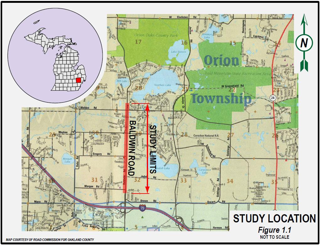
1 PROJECT DESCRIPTION This Environmental Assessment describes the proposed improvements to 2.05 miles of Baldwin Road from 0.15 miles south of Morgan Road to 0.27 miles north of Waldon Road, in Orion Township, located in Oakland County, Michigan (see Figure 1.1, page 1-2). Setting Orion Township is on the northern fringe of a major concentration of commercial development centered near the 1-75/M-59 interchange and is influenced by the growth of the Oakland County Automation Alley. The General Motors Orion Assembly Plant, located at Giddings and Silverbell, continues to be a major employer for the Township and surrounding areas providing jobs, tax base and as a magnet for other industrial expansion. Baldwin Road lies within the urban boundary limits of Oakland County and is classified as an urban minor arterial. This segment of Baldwin Road serves as a main north/south arterial roadway in this section of northern Oakland County. It provides a direct link to I-75 for Orion, Independence, Oxford and Brandon Townships as well as destinations further north in Lapeer County. Baldwin Road also provides an alternative route to M-24 in northern Oakland and southern Lapeer Counties. Baldwin Road in the study area is generally a two-lane undivided roadway with either gravel or paved shoulders. Over the years, several multi-lane improvements have been made at several high traffic volume intersections, such as Maybee Road and Waldon Road. Private development has added lanes at various locations throughout this portion of Baldwin Road to help facilitate turning movements into some commercial and residential developments. The portion of Baldwin Road under study is located 0.4 miles north of the I-75/Baldwin Road Interchange. It borders the Brown Road commercial area which is positioned between the north side of the freeway and Brown Road. Baldwin Road is a six-lane boulevard section from 0.64 miles south of the I-75 interchange up through Morgan Road. North of Morgan Road; Baldwin Road crests a sharp vertical curve and descends into the Gingellville area where it transitions to mainly a two-lane roadway. It widens to provide dedicated left-turn lanes and right-turn lanes at the signalized intersections of Gregory Road, Maybee Road and Waldon Road and at various business driveways with acceleration and deceleration tapers. The existing right-of-way (ROW) is predominantly 66 feet wide. ROW widths greater than 66 are found throughout the project area. There are 13 streets that intersect Baldwin Road within the study area and they are all twolane roads. September,
2 September,
3 Gingellville is an unincorporated area that stretches from Judah Road north to Maybee Road. Gingellville is comprised of several businesses, residences, community (churches, etc.) and municipal (fire station) facilities. The existing speed limit varies throughout the project limits. North of I-75 to Judah Road, the speed limit is 45 mph. It is 35 mph through Gingellville and increases back to 45 mph north of Maybee Road. Primary land use adjacent to the remainder of the Baldwin Road roadway is a combination of commercial, industrial, agricultural and residential (both multi-family and single-family). Study Background Increased development in Orion Township during the last two decades has been accompanied by increases in traffic congestion and crash frequency along Baldwin Road. Overall congestion and the potential hazard of making left turns into and out of residential driveways, subdivisions and businesses have been a primary concern voiced by residents to both Township and County officials for several years. RCOC s Master Plan ROW for this portion of Baldwin Road depicts a 150 width. Orion Township has a Master Land Use Plan as well as an Access Management Plan approved and in place. 1.2 PURPOSE FOR PROPOSED ACTION AND REGIONAL CONTEXT Purpose of the Project The purpose of this study is to evaluate proposed improvements to Baldwin Road between Morgan Road and Waldon Road and to enhance traffic safety while addressing mobility issues in the corridor by increasing capacity and improving access for the traveling public. Orion Township Officials have also expressed interest in multi-modal access, including pedestrian access, particularly in the Gingellville area. This will be accomplished by studying and evaluating road improvement alternatives that conform to current American Association of State Highway and Transportation Officials (AASHTO) design criteria. The proposed project will seek to improve traffic flow, mobility and safety for the users of the system, as well as encourage the economic development of the local community by: Providing a facility that will move traffic through the corridor safely and with minimal delays. Providing a facility that will help spur economic growth for this corridor in Orion September,
4 Township through increased capacity, safety and access with improved aesthetics. Providing a facility through Gingellville that addresses the mobility needs of the community while considering pedestrians and other modes of transportation. Providing a facility that will take into account the planned vision of the community as evidenced in the Gingellville Overlay District of the Orion Township Master Plan. Providing roadway improvements that consider the potential for the future streetscaping of the corridor. Existing Transportation Facilities Baldwin Road is the main transportation facility within the study area. Sidewalks are present but not uniform throughout the study area. Local public bus transportation in Oakland County is provided by the Southeast Michigan Area Rapid Transit (SMART). Currently, there are no bus routes operating directly along this portion of Baldwin Road however, SMART has a route that borders the southerly terminus of this study. Should a ridership need arise due to some future land use development, SMART could extend service northerly into the project corridor with minimum additional operational costs. Regional Growth and Development Orion Township is a member of the Southeast Michigan Council of Governments (SEMCOG), the metropolitan planning organization for this part of Michigan. SEMCOG provides a long-range forecast and comprehensive view of future demographic and economic changes. It provides base data for updating the long-range transportation plan and other regional planning projects. The SEMCOG data used in this document is reflective of the recent economic downturn as evidenced in the 2035 Regional Development Forecast (RDF) for Southeast Michigan. The data has not yet been changed to reflect the effects of the recent 2010 Census. Member communities still use the data in planning for infrastructure and development needs. SEMCOG's 2035 RDF provides detail on population, households and jobs for communities in Southeast Michigan. The forecast numbers are provided in five-year intervals from 2010 through future year The population and employment projections are discussed below: Population and Employment Projections Orion Township has experienced and is poised to continue to experience extensive residential, industrial and commercial development. This is mirrored by a continuing rapid increase in both population and employment in the Township. Table 1.1 presents the future growth in population and employment for Orion Township as projected by SEMCOG in its 2035 RDF. September,
5 131 Table Orion Township Projected Growth Year % Change Total Population 32,129 32,265 32,490 33,095 34,151 35, % Total Employment 11,896 11,905 12,390 13,174 14,237 15, % SOURCE: SEMCOG, 2035 Regional Development Forecast for Southeast Michigan Based on the data given in Table 1.1, SEMCOG has projected an approximate 11% population increase in Orion Township between 2010 and Employment in the Township is projected to increase by approximately 29% between 2010 and 2035 due to existing and planned industrial and commercial projects in the Township. As a comparison, over the same time period Oakland County s population is projected to increase by approximately 9.0%, while its employment is projected to increase by 10.7%. (See Table 1.2) Table 1.2 Oakland County Projected Growth Year % Change Total Population 1,226,169 1,235,849 1,249,154 1,272,065 1,303,678 1,336, % Total Employment 871, , , , , , % SOURCE: SEMCOG, 2035 Regional Development Forecast for Southeast Michigan In summary, the SEMCOG 2035 Forecast for Orion Township shows a continued growth trend in population and employment. Such growth, compounded by the general trend toward increased number of daily trips per household, is challenging the ability of local transportation agencies to address travel demands and system deficiencies. September,
6 Compatibility with Land Use and Transportation Plans SEMCOG has included the Baldwin Rd corridor in its long range Regional Transportation Plan (RTP) for a number of iterations of the plan. The preparation of this Environmental Assessment and the Preliminary Engineering efforts were funded in the Transportation Improvement Program (TIP) for FY The current TIP is showing the next phase, right-of-way acquisition, for FY-2013 based on widening the corridor from a two-lane road to a four-lane boulevard. The air conformity modeling done for the 2035 RTP assumes that this corridor will be widened to two travel lanes in each direction from north of I-75 to Waldon Rd. There are no other roadway improvements in the vicinity of Baldwin Rd assumed to be in place for the 2035 forecast. The Charter Township of Orion developed the latest version of their Township Master Plan in The existing land use within the Township and specifically the project corridor can be seen in Figure 1.2 on the next page. The Township has experienced significant changes in the land use characteristics of the community throughout the years. The following land use trends have been observed within the Township: As new roads were constructed or improved, housing development over the years has spread to the periphery of the Township. Since 1989, the Township has experienced a 41% increase in residential land use. Commercial uses, consisting primarily of local convenience businesses, service stations and restaurants, are scattered in individual locations throughout the study area. Office uses are primarily located along the main north/south arterials within the Township. Along Baldwin Road, small office nodes can be found at the intersections with Judah Road and Waldon Road. September,


7 Baldwin Road Study Corridor Waldon Maybee Baldwin Gregory Judah Morgan Figure 1.2: Existing Land Use Plan Orion Township (courtesy of Carlisle-Wortman Assoc., Inc.) As a growing community, future improvements in the Township will need to coordinate land use development and transportation planning. The future land use for the area within the project study corridor, as set forth in the Township s Master Plan, can be seen in Figure 1.3. September,
 As depicted in the exhibit, the majority of the area around Gingellville is labeled as Village Center.")
8 Gingellville Village Center Figure 1.3: Future Land Use Plan Orion Township (courtesy of Carlisle-Wortman Assoc., Inc.) As depicted in the exhibit, the majority of the area around Gingellville is labeled as Village Center. The Township envisions a village center that, through future development, would provide the important residential services needed for local neighborhood areas. The future developments would be connected through a system of pedestrian walkways. The Township has adopted the 2005 Gingellville Village Design Plan and Guidelines to help foster the Village Center concept for Gingellville. This plan is shown in Figure 1.4 on the next page. The congestion problems within the area, the abundance of available land and the desired intent to preserve the historical hamlet of Gingellville are the key elements this development concept will address. The Township policies for this sub-area focus on clustered, mixed use village style rather than strip commercial development land use patterns. September,
 239 240 241 242 243 244 245 246 247 248 249 250 251 252 253 254 255 256 257 258 259 260 261 262 263 264 265 266 267 268 269 270 271 272 273 274 275 276 277 278 279 280 281 Studies have found the")
9 Figure 1.4: 2005 Gingellville Village Design Plan Orion Township (Courtesy of Carlisle-Wortman Assoc., Inc.) Studies have found the number and location of driveways greatly influences how a roadway functions. Reducing the number of driveways, improving driveway spacing and providing other geometric improvements (e.g., exclusive turn lanes) improve traffic flow and reduce the number of crashes and pedestrian conflicts. Orion Township has prepared an Access Management Plan (AMP) and has included it as part of the Township s Master Plan. They recognize the benefits of a good AMP to improve traffic operations and safety along Baldwin Road. RCOC supports the Township s efforts to improve the safety and capacity of the Baldwin Road corridor by implementing facets of their AMP. The preferred alternative to be selected as a result of this study will need to be compatible with the ideals put forward with both the Gingellville Design Plan and Township Master Plan so the Township s vision for their community is realized. September,
10 NEED FOR PROPOSED ACTION The current roadway is inadequate to meet current and future transportation needs. Residential and commercial growth in and near the project area has caused increased traffic demands that require highway capacity to improve traffic flow and safety for the area residents. By the year 2035, traffic along Baldwin Road is projected to substantially increase. This increase will result in greater traffic congestion and lower levels of service on Baldwin Road and many of the adjacent cross streets. Factors directly affecting the need for this project include the following: Increased traffic congestion and travel delays in the corridor. Traffic flow is limited by both the nodes (intersections) and links (roadway width) found within the project area. Existing geometric deficiencies such as sub-standard sight distance. Inadequate roadway and shoulder width. Safety issues as evidenced by high crash rates within the project area. Crash types within the project area are consistent with those found in areas of high congestion. The existing pavement section does not have the structural capacity to handle the increased traffic loads and is the primary reason for the poor pavement condition. The entire pavement section needs to be reconstructed to handle the increase traffic demands. Lack of multimodal accommodations within the project area, specifically pedestrian facilities consistent with a walkable/bikeable community. Regional mobility constraints due to unimproved roadway segments, especially during peak hours and in consideration of future local events within the surrounding area. Desire of the local community to have a modern infrastructure to help support the community s vision for the corridor. System Capacity Traffic Growth Rates The Baldwin Road Environmental Assessment will account for the safety and capacity needs of the Baldwin Road corridor over the next 25 years, through the year As part of this analysis, current traffic volumes were collected and form the basis for the forecasting used to estimate future traffic volumes. The latest traffic growth data were obtained in November 2009 from SEMCOG. SEMCOG uses a travel demand model to analyze traffic patterns and congestion on a regional level. The data was further refined to be representative of traffic patterns at a community level as well as to account for local proposed developments in the September,
11 study area. For purposed of this report, the traffic growth rates shown are cumulative changes from 2010 to The refined SEMCOG growth rates are shown graphically and discussed thoroughly in Appendix A and are summarized in Table 1.3 below: Table 1.3 Traffic Growth Rates* Road Name Limits 2010 ADT 2035 ADT % Change** Baldwin Road North of Gregory 22,340 30,100 35% South of Gregory 24,680 31,160 25% Waldon Road West of Baldwin 3,840 4,320 15% East of Baldwin 8,150 8,640 5% Thornwood Road All 1,200 1,200 0% Maybee Road West of Baldwin 6,630 7,210 10% East of Baldwin 4,740 4,740 0% Hidden Timber All % Gregory Road All 1,940 1,940 0% Judah Road All % Morgan Road All 1,530 1,530 0% Brown Road*** North Side 15,570 28,040 80% * Growth Rate is the cumulative change between 2010 and 2035 ** Percent change focuses on anticipated peak volumes, not ADT *** Brown Road was included in the capacity analysis, although it is outside the project limits of the Environmental Assessment. Its inclusion is important because significant changes on Brown Road will have corresponding impacts to Baldwin Road in the study area. Brown Road is located just 0.2 miles south of Morgan, where several big-box stores (including Costco, Target and Meijer) and casual-dining are located on the south side of Brown Road within the City of Auburn Hills. Consequently, Brown carries significant traffic volumes at this time. The north side of Brown Road within Orion Township is currently undeveloped. As the properties along the north side of Brown are redeveloped, traffic volumes on Brown Road are expected to increase substantially with that could result in impacts to Baldwin Road within the study area. For this reason, a growth rate of 80% has been used for Brown Road. Traffic Volumes Baldwin Road carries a relatively large volume of traffic for a two-lane facility. As can be seen in the following two figures, the existing traffic volumes (Figure 1.5) are very high and they grow to larger levels in 2035 (Figure 1.6). The AM peak hour was identified as between 7:15 AM to 8: 15 AM and the PM peak was between 4:45 PM and 5:45 PM. There is a very distinct direction bias between the AM and PM peak hours. This is largely due to commuters traveling south in the morning to get to work and returning home in the northbound direction at night. September,
12 Figure 1.5: 2010 Peak Hour Volumes Baldwin Road September,

13 Section 1 Figure 1.6: 2035 Peak Hour Volumes Baldwin Road September,
14 According to the National Cooperative Highway Research Program (NCHRP) Report 330, Effective Utilization of Street Width on Urban Arterials (August 1990), two-lane roadways can generally accommodate 5,000 to 7,000 vehicles per day (vpd) at acceptable levels of service. Facilities without closely spaced signals or commercial development (or both) may provide adequate service on streets with traffic volumes up to 15,000 vpd. However, more typically, two-lane facilities above the 5,000 to 7,000 vpd level experience peak hour congestion and/or increased accidents suggesting the need to upgrade the facility with a multi-lane design alternative. Current Baldwin Road traffic volumes vary between 13,000 and 21,000 vpd. Future volumes range from 30,100 to 31,160 vpd. Hence, as a two-lane roadway, Baldwin Road is currently over capacity. Capacity Analysis and Corridor Modeling The intersections within the study area were analyzed using Synchro/SimTraffic V7 software, which generally conforms to the methodologies published in the Highway Capacity Manual (HCM), 2000 Edition. The newer 2010 Edition of the HCM became available after all the intersection analysis was completed for in this study. The analyses were used to determine the Level of Service (LOS) values for each intersection movement. LOS is based on factors such as number and types of lanes, intersection controls such as stop signs or traffic signals, traffic volumes, pedestrian volumes, etc. LOS is expressed as a letter grade, in a range from A through F. In this context, LOS A represents the best conditions, with very little or no average delay to vehicles. LOS F is the worst of conditions, equated with very large average delays and few gaps of acceptable length. Further explanation of LOS can be found in Appendix A. LOS C is considered by many traffic safety professionals to be the minimum acceptable condition in rural areas, and LOS D is the minimum for urban/suburban areas. Given the location of this site within the urbanized boundary, LOS D was utilized as the study's minimum goal. All stakeholders concur with this LOS goal. Capacity analyses were performed for each intersection during both the morning and afternoon peak periods. Existing conditions reflect the volumes observed during turning movement counts. Future conditions reflect the 2035 projected volumes and assumes Baldwin Road would remain a two-lane roadway with the same intersection lane configuration that exists today. For each scenario, using existing and future conditions, it was assumed all traffic signals within the study would be retimed and optimized. Table 1.4 shows both the existing and future LOS of the signalized intersections located within the project study limits. Table 1.5 shows the existing and future LOS for the primary unsignalized intersections. September,
15 Table Existing and Future LOS - Signalized Intersections (1) Intersection Baldwin Road and Waldon Road Baldwin Road and Maybee Road Baldwin Road and Gregory Road Existing (2010) Future (2035) PM AM LOS (DELAY 3 ) LOS (DELAY 3 ) AM LOS (DELAY 3 ) (1) Results from Synchro / SimTraffic, Version 7 software modeling. (3) Delay is measured in seconds/vehicle. (4) This movement is the critical movement for the intersection. PM LOS (DELAY 3 ) Overall C (24.0) C (24.6) D (45.0) E (55.3) NB (4) B (14.0) B (16.7) B (18.2) E (63.8) SB (4) C (21.4) B (16.7) D (47.6) C (20.6) Overall C (24.6) B (17.9) E (65.9) D (50.6) NB (4) A (6.7) B (10.9) A (5.9) E (65.5) SB (4) C (23.0) B (15.5) F (86.7) C (22.7) Overall C (23.4) B (14.1) F (124.4) E (66.3) NB (4) A (1.9) B (17.4) A (2.8) E (68.8) SB (4) C (26.0) A (3.3) F (148.7) D (43.7) Table Existing & Future LOS Primary Unsignalized Intersections (2) UNSIGNALIZED (HCM) Baldwin Road and Hidden Timber Drive Baldwin Road and Judah Road Baldwin Road and Morgan Road (2) Results from Highway Capacity Manual, 2000 edition modeling.. (3) Delay is measured in seconds/vehicle. (4) This movement is the critical movement for the intersection. Definitions: Err=delay per vehicle too large for software to calculate; lt = left Existing (2010) Future (2035) AM LOS (DELAY 3 ) PM LOS (DELAY 3 ) AM LOS (DELAY 3 ) PM LOS (DELAY 3 ) SB lt (4) A (7.9) D (29.5) B (8.1) F (495.3) WB (4) E (41.7) F (Err) F (137.8) F (Err) SB lt (4) A (0.1) A (0.5) A (0.0) A (2.7) WB (4) C (20.7) F (76.6) E (37.6) F (836.9) NB lt (4) B (13.6) A (9.6) C (17.3) B (10.6) EB (4) F (55.5) F (Err) F (183.9) F (Err) It should be noted that although an intersection may show an acceptable overall LOS, individual movements often fail at LOS D, E or F. The two tables show the intersections are currently operating with considerable delay. As can be expected, as traffic volumes on Baldwin Road grow, the delays shown for these intersections increase with a corresponding deterioration in LOS. Roadway Safety A safety review and crash analysis was performed for a 36-month period (January 1, 2007 through December 31, 2009) on Baldwin Road between Morgan Road and Waldon Road. Crash rates were computed for specific intersections within this area. The crash rates were then compared to region wide crash rates for similar types of intersections. The crash rates were measured as crashes per million entering vehicles (MEV). Table 1.6 presents the results of the crash analysis. September,
16 Table Intersection Crash Rates ( ) Baldwin Road Intersection Total # of Crashes Crash Rate (per MEV) Morgan/Jordan Judah Gregory Maybee Waldon Crash Type Breakdown 3 angle 4 rear-end 9 side-swipe 3 angle 10 rear-end 1 side-swipe 5 angle 9 rear-end 3 head-left 8 angle 34 rear-end 3 side-swipe 10 angle 5 head-left 1 head-on 19 rear-end 3 side-swipe The Oakland County average crash rate for a similar roadway facility during the same time period is 0.79 crashes per MEV. As can be seen in Table 1.5, there are several intersections with crash rates above the Oakland County average. From January 1, 2007 through December 31, 2009, there were a total of 244 crashes for the entire study area with 47 of them being injury crashes and no fatality crashes. Although some of the intersections have a higher than average crash rate, Baldwin Road in general has a relatively low crash rate when looked at from a regional perspective. This is illustrated in the most recent SEMCOG Safety Deficiency Analysis information shown in Figure 1.7 on the following page. September,

17 Baldwin Road Study Corridor Figure 1.7: SEMCOG Safety Deficiency Analysis for Southeast Michigan To meet the growth needs of this corridor, one specific component of all the alternatives being considered involves adding another lane in each direction of travel. This will have a dramatic effect on the overall safety of the corridor. According to NCHRP Report 330, the advantages of a multi-lane roadway over a two-lane roadway are discussed as follows: Provides additional lanes to increase capacity for through traffic movement. Reduces delay to through vehicles caused by left-turning vehicles. Reduces frequency of rear-end and angle crashes associated with left-turn maneuvers. Provides spatial separation between opposing lanes to reduce head-on crashes. Increases operational flexibility. The improved operations and geometry inherent in a multi-lane versus a two-lane facility create a safer roadway. Studies have shown the implementation of multi-lane roadways have reduced crash rates by 19 to 35%. Each alternative will also feature modern roundabouts for the major intersections. Roundabouts have proven to reduce overall crashes by up to 39% and injury-related crashes by 79%, according to the Insurance Institute for Highway Safety (IIHS) study done in That study evaluated 23 U.S. intersections that were converted from stop or signal controlled intersections to modern roundabouts. More recently, a NCHRP No (2006) has verified the collision reduction findings of the IIHS study, with a reduction for injury crashes of 75.8%. Looking at the conversion results of 90 U.S. locations, NCHRP 3-65 further separates the safety improvements by previous intersection control (two-way stop, all-way stop or signalized), study area (urban, suburban, rural) and number of entry lanes. September,
Market Street PDP. Nassau County, Florida. Transportation Impact Analysis. VHB/Vanasse Hangen Brustlin, Inc. Nassau County Growth Management
 Transportation Impact Analysis Market Street PDP Nassau County, Florida Submitted to Nassau County Growth Management Prepared for TerraPointe Services, Inc. Prepared by VHB/Vanasse Hangen Brustlin, Inc.
NATHAN HALE HIGH SCHOOL PARKING AND TRAFFIC ANALYSIS. Table of Contents
 Parking and Traffic Analysis Seattle, WA Prepared for: URS Corporation 1501 4th Avenue, Suite 1400 Seattle, WA 98101-1616 Prepared by: Mirai Transportation Planning & Engineering 11410 NE 122nd Way, Suite
Traffic Impact Study
 Traffic Impact Study Statham DRI One University Parkway Prepared for: Barrow County Prepared by: October 2012 Table of Contents Executive Summary i Section 1. Introduction 1 Project Description 1 Methodology
Appendixx C Travel Demand Model Development and Forecasting Lubbock Outer Route Study June 2014
 Appendix C Travel Demand Model Development and Forecasting Lubbock Outer Route Study June 2014 CONTENTS List of Figures-... 3 List of Tables... 4 Introduction... 1 Application of the Lubbock Travel Demand
III. FORECASTED GROWTH
 III. FORECASTED GROWTH In order to properly identify potential improvement projects that will be required for the transportation system in Milliken, it is important to first understand the nature and volume
Table of Contents Introduction... 4 Study Area... 5
 Table of Contents Introduction... 4 Study Area... 5 Streets and s... 5 Traffic Volumes... 8 Recent and Anticipated Development... 10 Crash Analysis... 10 Projected Traffic Volumes... 11 Trip Generation...
3.0 ANALYSIS OF FUTURE TRANSPORTATION NEEDS
 3.0 ANALYSIS OF FUTURE TRANSPORTATION NEEDS In order to better determine future roadway expansion and connectivity needs, future population growth and land development patterns were analyzed as part of
CVS Derwood. Local Area Transportation Review
 CVS Derwood Montgomery County, Maryland May 27, 2016 Local Area Transportation Review Prepared for: JC Bar Properties, Inc. Steve Fleming, PE 415 Fallowfield Road, Suite 301 Camp Hill, Pennsylvania 17011
WEBER ROAD RESIDENTIAL DEVELOPMENT Single Family Residential Project
 WEBER ROAD RESIDENTIAL DEVELOPMENT Single Family Residential Project WEBER ROAD RESIDENTIAL DEVELOPMENT TRAFFIC IMPACT STUDY TABLE OF CONTENTS 1.0 Executive Summary Page 2.0 Introduction 2.1 DEVELOPMENT
TRAFFIC IMPACT STUDY. Platte Canyon Villas Arapahoe County, Colorado (Arapahoe County Case Number: Z16-001) For
 For") TRAFFIC IMPACT STUDY For Platte Canyon Villas Arapahoe County, Colorado (Arapahoe County Case Number: Z16-001) February 2015 Revised: August 2015 April 2016 July 2016 September 2016 Prepared for: KB Home
TRAFFIC IMPACT STUDY For Platte Canyon Villas Arapahoe County, Colorado (Arapahoe County Case Number: Z16-001) February 2015 Revised: August 2015 April 2016 July 2016 September 2016 Prepared for: KB Home
JEP John E. Jack Pflum, P.E. Consulting Engineering 7541 Hosbrook Road, Cincinnati, OH Telephone:
 JEP John E. Jack Pflum, P.E. Consulting Engineering 7541 Hosbrook Road, Cincinnati, OH 45243 Email: jackpflum1@gmail.com Telephone: 513.919.7814 MEMORANDUM REPORT Traffic Impact Analysis Proposed Soccer
WOODRUFF ROAD CORRIDOR ORIGIN-DESTINATION ANALYSIS
 2018 WOODRUFF ROAD CORRIDOR ORIGIN-DESTINATION ANALYSIS Introduction Woodruff Road is the main road to and through the commercial area in Greenville, South Carolina. Businesses along the corridor have
April 10, Mr. Curt Van De Walle, City Manager City of Castle Hills 209 Lemonwood Drive Castle Hills, Texas 78213
 Mr. Curt Van De Walle, City Manager City of Castle Hills 209 Lemonwood Drive Castle Hills, Texas 78213 Subject: Revised Castle Hills BASIS Charter School Traffic Impact Analysis Review City of Castle Hills,
Expanding the GSATS Model Area into
 Appendix A Expanding the GSATS Model Area into North Carolina Jluy, 2011 Table of Contents LONG-RANGE TRANSPORTATION PLAN UPDATE 1. Introduction... 1 1.1 Background... 1 1.2 Existing Northern Extent of
Study Overview. the nassau hub study. The Nassau Hub
 Livable Communities through Sustainable Transportation the nassau hub study AlternativeS analysis / environmental impact statement The Nassau Hub Study Overview Nassau County has initiated the preparation
Focused Traffic Analysis for the One Lincoln Park Project
 September 15, 2015 Mr. Bill Johnson Coldwell Banker 511 Sir Francis Drake Boulevard Greenbrae, CA 94904 Focused Traffic Analysis for the One Lincoln Park Project Dear Mr. Johnson; As requested, W-Trans
6 th Line Municipal Class Environmental Assessment
 6 th Line Municipal Class Environmental Assessment County Road 27 to St John s Road Town of Innisfil, ON September 6, 2016 APPENDIX L: TRAVEL DEMAND FORECASTING MEMORANDUM Accessible formats are available
Committee Meeting November 6, 2018
 Committee Meeting November 6, 2018 Agenda Where we are in the process Land Use Plan Transportation Element Housing & Neighborhoods Elements Next Steps Schedule November 6: Plan Elements December: Plan
King City URA 6D Concept Plan
 King City URA 6D Concept Plan King City s Evolution Among the fastest growing cities 2000 Census 1,949 2010 Census 3,111 60% increase 2016 Census estimate 3,817 23% increase Average annual rate 4.3% Surpassing
COUNCIL POLICY MANUAL
 COUNCIL POLICY MANUAL SECTION: PUBLIC WORKS SUBJECT: SNOW & ICE CONTROL POLICY 2012/2013 GOAL: Pages: 1 of 10 Approval Date: Dec. 3, 2012 Res. # 1001/2012 To annually identify the winter maintenance costs
MEMORANDUM. The study area of the analysis was discussed with City staff and includes the following intersections:
 MEMORANDUM DATE: JULY 6, 2012 TO: FROM: RE: CC: MELANIE KNIGHT BRAD BYVELDS/ JENNIFER LUONG 1050 SOMERSET STREET PRELIMINARY TRAFFIC ANALYSIS OUR FILE NO. 111152 NEIL MALHOTRA The purpose of this memo
Technical Memorandum #2 Future Conditions
 Technical Memorandum #2 Future Conditions To: Dan Farnsworth Transportation Planner Fargo-Moorhead Metro Council of Governments From: Rick Gunderson, PE Josh Hinds PE, PTOE Houston Engineering, Inc. Subject:
PLAZA MEXICO RESIDENCES
 PLAZA MEXICO RESIDENCES TRAFFIC STUDY PREPARED FOR: 3000 E. IMPERIAL, LLC. 6940 Beach Boulevard, D-501 Buena Park, California 90621 PREPARED BY: OCTOBER 5, 2017 translutions the transportatio n solutions
I-95/I-85 INTERCHANGE ROADWAY SAFETY ASSESSMENT
 FINAL REPORT I-95/I-85 INTERCHANGE ROADWAY SAFETY ASSESSMENT Prepared for: Prepared by: 117306012.B MARCH 2013 Final Report March 2013 I-95/I-85 Interchange ROADWAY SAFETY ASSESSMENT Prepared for: Prepared
GIS ANALYSIS METHODOLOGY
 GIS ANALYSIS METHODOLOGY No longer the exclusive domain of cartographers, computer-assisted drawing technicians, mainframes, and workstations, geographic information system (GIS) mapping has migrated to
California Urban Infill Trip Generation Study. Jim Daisa, P.E.
 California Urban Infill Trip Generation Study Jim Daisa, P.E. What We Did in the Study Develop trip generation rates for land uses in urban areas of California Establish a California urban land use trip
MnDOT Method for Calculating Measures of Effectiveness (MOE) From CORSIM Model Output
 From CORSIM Model Output") MnDOT Method for Calculating Measures of Effectiveness (MOE) From CORSIM Model Output Rev. April 29, 2005 MnDOT Method for Calculating Measures of Effectiveness (MOE) From CORSIM Model Output Table of
MnDOT Method for Calculating Measures of Effectiveness (MOE) From CORSIM Model Output Rev. April 29, 2005 MnDOT Method for Calculating Measures of Effectiveness (MOE) From CORSIM Model Output Table of
Appendix C Traffic Study
 Final Environmental Impact Statement Appendix C Traffic Study Schofield Generating Station Project, Hawaii October 2015 C-1 Final Environmental Impact Statement This page intentionally left blank. Schofield
Final City of Colusa STREETS & ROADWAYS MASTER PLAN. October J Street Suite 390 Sacramento, CA 95814
 Final City of Colusa STREETS & ROADWAYS MASTER PLAN October 2009 660 J Street Suite 390 Sacramento, CA 95814 TABLE OF CONTENTS I. INTRODUCTION... 1 Report Organization...1 II. ANALYSIS METHODOLOGY... 2
GIS Analysis of Crenshaw/LAX Line
 PDD 631 Geographic Information Systems for Public Policy, Planning & Development GIS Analysis of Crenshaw/LAX Line Biying Zhao 6679361256 Professor Barry Waite and Bonnie Shrewsbury May 12 th, 2015 Introduction
APPENDIX I: Traffic Forecasting Model and Assumptions
 APPENDIX I: Traffic Forecasting Model and Assumptions Appendix I reports on the assumptions and traffic model specifications that were developed to support the Reaffirmation of the 2040 Long Range Plan.
Local Calibration Factors for Implementing the Highway Safety Manual in Maine
 Local Calibration Factors for Implementing the Highway Safety Manual in Maine 2017 Northeast Transportation Safety Conference Cromwell, Connecticut October 24-25, 2017 MAINE Darryl Belz, P.E. Maine Department
Appendix I: Traffic Study
 City of Fontana Sierra Lakes Commerce Center Draft EIR Appendix I: Traffic Study FirstCarbon Solutions H:\Client (PN JN)\0144\01440050\EIR\1 ADEIR\01440050 Sec99 99 Appendix Dividers.doc THIS PAGE INTENTIONALLY
APPENDIX IV MODELLING
 APPENDIX IV MODELLING Kingston Transportation Master Plan Final Report, July 2004 Appendix IV: Modelling i TABLE OF CONTENTS Page 1.0 INTRODUCTION... 1 2.0 OBJECTIVE... 1 3.0 URBAN TRANSPORTATION MODELLING
Forecasts for the Reston/Dulles Rail Corridor and Route 28 Corridor 2010 to 2050
 George Mason University Center for Regional Analysis Forecasts for the Reston/Dulles Rail Corridor and Route 28 Corridor 21 to 25 Prepared for the Fairfax County Department of Planning and Zoning Lisa
FY 2010 Continuing i Planning Program Product Report. Local Transportation and Traffic Data. Wood-Washington-Wirt Interstate Planning Commission
 FY 2010 Continuing i Planning Program Product Report Local Transportation and Traffic Data Travel Time and Delay Data for Belpre and Marietta, Ohio Wood-Washington-Wirt Interstate Planning Commission CONTINUING
Updating the Urban Boundary and Functional Classification of New Jersey Roadways using 2010 Census data
 Updating the Urban Boundary and Functional Classification of New Jersey Roadways using 2010 Census data By: Glenn Locke, GISP, PMP 1 GIS-T May, 2013 Presentation Overview Purpose of Project Methodology
TREASURE COAST REGIONAL PLANNING COUNCIL M E M O R A N D U M. To: Council Members AGENDA ITEM 4B10
 TREASURE COAST REGIONAL PLANNING COUNCIL M E M O R A N D U M To: Council Members AGENDA ITEM 4B10 From: Date: Subject: Staff December 14, 2018 Council Meeting Local Government Comprehensive Plan Review
CITY OF NEW LONDON WINTER ROAD & SIDEWALK MAINTENANCE POLICY
 CITY OF NEW LONDON WINTER ROAD & SIDEWALK MAINTENANCE POLICY GENERAL The purpose of this policy is to set up acceptable procedures and policies for the winter maintenance of public areas in the City of
Snow and Ice Control POLICY NO. P-01/2015. CITY OF AIRDRIE Snow and Ice Control Policy
 Page 1 CITY OF AIRDRIE Snow and Ice Control Effective Date: Approved By: Approved On: March 17, 2015 City Council March 16, 2015 Revision Date: Resolution #: ------ PURPOSE: The City of Airdrie is responsible
StanCOG Transportation Model Program. General Summary
 StanCOG Transportation Model Program Adopted By the StanCOG Policy Board March 17, 2010 What are Transportation Models? General Summary Transportation Models are technical planning and decision support
FINAL Traffic Report for the Proposed Golden Valley Road and Newhall Ranch Road Projects in the City of Santa Clarita, California May 5, 2005
 FINAL Traffic Report for the Proposed Golden Valley Road and Newhall Ranch Road Projects in the City of Santa Clarita, California May 5, 2005 Prepared For: EDAW, Inc. 1420 Kettner Boulevard, Suite 620
Roundabout Level of Service
 Roundabout Level of Service Rahmi Akçelik Director Akcelik & Associates Pty Ltd email: rahmi.akcelik@sidrasolutions.com web: www.sidrasolutions.com 8 January 2009 Contents 1. Introduction... 1 2. Fundamental
Brandywine Road Speed Study FINAL REPORT
 Brandywine Road Speed Study FINAL REPORT City of Albuquerque Brandywine Road Speed Study Final Report Albuquerque, New Mexico City of Albuquerque May, 2016 Brandywine Road Speed Study Final Report City
TRANSPORTATION IMPACT STUDY WHEELER STREET CLOSURE
 TRANSPORTATION IMPACT STUDY WHEELER STREET CLOSURE Village of Greene, Chenango County, New York Prepared for: VILLAGE OF GREENE 49 Genesee Street Greene, NY 13778 Prepared by: LARSON DESIGN GROUP 1000
Subject: Desert Palisades Specific Plan - Tram Way Access Sight Distance
 Endo Engineering Traffic Engineering Air Quality Studies Noise Assessments July 13, 2015 Mr. Ed Freeman Pinnacle View, LLC P.O. Box 1754 Lake Oswego, OR 97035-0579 Subject: Desert Palisades Specific Plan
CONTINUING PLANNING PROGRAM LOCAL TRANSPORTATION AND TRAFFIC DATA PRODUCT REPORT [OH Corridors]
![CONTINUING PLANNING PROGRAM LOCAL TRANSPORTATION AND TRAFFIC DATA PRODUCT REPORT [OH Corridors]](/thumbs/94/120123757.jpg "CONTINUING PLANNING PROGRAM LOCAL TRANSPORTATION AND TRAFFIC DATA PRODUCT REPORT [OH Corridors]") CONTINUING PLANNING PROGRAM LOCAL TRANSPORTATION AND TRAFFIC DATA PRODUCT REPORT [OH Corridors] Travel Time and Delay Analysis for Belpre (OH) and Marietta (OH) Fiscal Year 2009 Report WOOD WASHINGTON
CONTINUING PLANNING PROGRAM LOCAL TRANSPORTATION AND TRAFFIC DATA PRODUCT REPORT [OH Corridors] Travel Time and Delay Analysis for Belpre (OH) and Marietta (OH) Fiscal Year 2009 Report WOOD WASHINGTON
2014 Certification Review Regional Data & Modeling
 2014 Certification Review Regional Data & Modeling July 22, 2014 Regional Data Census Program Coordination PAG works with and for member agencies to ensure full participation in all Census Bureau programs
Appendix C Final Methods and Assumptions for Forecasting Traffic Volumes
 Fairview Ave. and Main St. Improvements and Local Streets Plan Appendices Ada County Highway District Appendix C Final Methods and Assumptions for Forecasting Traffic Volumes January 3, 207 Appendices
HORIZON 2030: Land Use & Transportation November 2005
 PROJECTS Land Use An important component of the Horizon transportation planning process involved reviewing the area s comprehensive land use plans to ensure consistency between them and the longrange transportation
MODELING OF 85 TH PERCENTILE SPEED FOR RURAL HIGHWAYS FOR ENHANCED TRAFFIC SAFETY ANNUAL REPORT FOR FY 2009 (ODOT SPR ITEM No.
 MODELING OF 85 TH PERCENTILE SPEED FOR RURAL HIGHWAYS FOR ENHANCED TRAFFIC SAFETY ANNUAL REPORT FOR FY 2009 (ODOT SPR ITEM No. 2211) Submitted to: Ginger McGovern, P.E. Planning and Research Division Engineer
Economic Activity Economic A ctivity
 5 Economic Economic Activity Activity ECONOMIC ACTIVITY 5.1 EMPLOYMENT... 5-7 5.1.1 OBJECTIVE... 5-7 5.1.2 POLICIES... 5-7 5.2 PROTECTING THE AREA OF EMPLOYMENT... 5-9 5.2.1 OBJECTIVE... 5-9 5.2.2 POLICIES...
I. M. Schoeman North West University, South Africa. Abstract
 Urban Transport XX 607 Land use and transportation integration within the greater area of the North West University (Potchefstroom Campus), South Africa: problems, prospects and solutions I. M. Schoeman
APPENDIX I - AREA PLANS
 ROUTE 37 WEST LAND USE PLAN ROUTE 37 WEST LAND USE PLAN Recent land use decisions and development trends have drawn attention to the land within the Route 37 western by-pass area between Route 50 and
North Carolina s First Quadrant Left: History and Lessons Learned
 North Carolina s First Quadrant Left: History and Lessons Learned Michael P. Reese, P.E. (Corresponding Author) Congestion Management Section Project Engineer North Carolina Department of Transportation
PW 001 SNOW REMOVAL AND SANDING FOR ROADWAYS AND SIDEWALKS October 6, 2014 (#223-14) Original October 19, 2015; October 15, 2018 Public Works
 Original October 19, 2015; October 15, 2018 Public Works") Policy Statement: The Village of Kitscoty will provide snow and ice control on municipal streets and sidewalks according to determined priorities. Purpose: To provide direction and information to employees
Policy Statement: The Village of Kitscoty will provide snow and ice control on municipal streets and sidewalks according to determined priorities. Purpose: To provide direction and information to employees
CHAPTER 3. CAPACITY OF SIGNALIZED INTERSECTIONS
 CHAPTER 3. CAPACITY OF SIGNALIZED INTERSECTIONS 1. Overview In this chapter we explore the models on which the HCM capacity analysis method for signalized intersections are based. While the method has
Environmental Analysis, Chapter 4 Consequences, and Mitigation
 Environmental Analysis, Chapter 4 4.17 Environmental Justice This section summarizes the potential impacts described in Chapter 3, Transportation Impacts and Mitigation, and other sections of Chapter 4,
Metrolinx Transit Accessibility/Connectivity Toolkit
 Metrolinx Transit Accessibility/Connectivity Toolkit Christopher Livett, MSc Transportation Planning Analyst Research and Planning Analytics Tweet about this presentation #TransitGIS OUTLINE 1. Who is
The effects of impact fees on urban form and congestion in Florida
 The effects of impact fees on urban form and congestion in Florida Principal Investigators: Andres G. Blanco Ruth Steiner Presenters: Hyungchul Chung Jeongseob Kim Urban and Regional Planning Contents
Regional Growth Strategy Work Session Growth Management Policy Board
 Regional Growth Strategy Work Session Growth Management Policy Board September 6, 2018 1 Overview Recap June GMPB work session Objectives and outcomes Regional geographies Growth scenarios Breakout Discussion:
International Journal of Scientific & Engineering Research Volume 9, Issue 6, June ISSN
 International Journal of Scientific & Engineering Research Volume 9, Issue 6, June-2018 109 Quantifying Traffic Congestion by Studying Traffic Flow Characteristics in Wolaita Sodo Town, Ethiopia Mengistu
City of Saginaw Right of Way Division Snow and Ice Removal Policy January 18, 2016
 Snow and Ice Removal Policy January 18, 2016 It is the policy of the to provide snowplowing and ice removal services in order to: Provide safe traveling conditions for motorists and pedestrians Assist
North Carolina s First Quadrant Left: History and Lessons Learned
 0 0 0 North Carolina s First Quadrant Left: History and Lessons Learned Michael P. Reese, P.E. (Corresponding Author) Congestion Management Section Project Engineer North Carolina Department of Transportation
Metro Emergency Security Operations Center (ESOC) 410 Center Street City of Los Angeles
 410 Center Street City of Los Angeles") Metro Emergency Security Operations Center (ESOC) 410 Center Street City of Los Angeles Traffic Study August 31, 2015 AECOM 515 South Flower Street, 4 th Floor Los Angeles, CA 90071 Job Number: 60323255
Metro Emergency Security Operations Center (ESOC) 410 Center Street City of Los Angeles Traffic Study August 31, 2015 AECOM 515 South Flower Street, 4 th Floor Los Angeles, CA 90071 Job Number: 60323255
US 20 Highway Safety Study
 US 20 Highway Safety Study Corvallis City Limits to Springhill Road, Albany Prepared for Prepared by December 2016 US 20 HIGHWAY SAFETY STUDY FINAL REPORT Benton County, Oregon Prepared for: Oregon Department
Typical information required from the data collection can be grouped into four categories, enumerated as below.
 Chapter 6 Data Collection 6.1 Overview The four-stage modeling, an important tool for forecasting future demand and performance of a transportation system, was developed for evaluating large-scale infrastructure
Palmerston North Area Traffic Model
 Palmerston North Area Traffic Model Presentation to IPWEA 7 November 2014 PNATM Presentation Overview Model Scope and type Data collected The model Forecasting inputs Applications PNCC Aims and Objectives
TRAFFIC IMPACT STUDY MANUFACTURING COMPANY
 TRAFFIC IMPACT STUDY For MANUFACTURING COMPANY Prepared For: Airway Heights, WA Prepared By: SUNBURST ENGINEERING, P. S. 4310 S. Ball Dr. Veradale, WA 99037 April, 2013 TRAFFIC IMP ACT STUDY Manufacturing
Regional Transit Development Plan Strategic Corridors Analysis. Employment Access and Commuting Patterns Analysis. (Draft)
") Regional Transit Development Plan Strategic Corridors Analysis Employment Access and Commuting Patterns Analysis (Draft) April 2010 Contents 1.0 INTRODUCTION... 4 1.1 Overview and Data Sources... 4 1.2
Regional Transit Development Plan Strategic Corridors Analysis Employment Access and Commuting Patterns Analysis (Draft) April 2010 Contents 1.0 INTRODUCTION... 4 1.1 Overview and Data Sources... 4 1.2
The Highline Development Traffic Impact Study
 The Highline Development Traffic Impact Study Columbia Falls, Montana Prepared For: TD&H Engineering 450 Corporate Drive, Suite 101 Kalispell, MT 59901 June, 2018 130 South Howie Street Helena, Montana
Alternatives Analysis
 Alternatives Analysis Prepared for: Metropolitan Atlanta Rapid Transit Authority Prepared by: AECOM/Jacobs-JJG Joint Venture Atlanta, GA November 2012 Page Left Intentionally Blank ii TABLE OF CONTENTS
COUNCIL POLICY BACKGROUND
 COUNCIL POLICY Policy Title: Snow and Ice Control Policy Policy Number: TP004 Report Number: TTP2003-39, C2007-44, LPT2011-57 Approved by: City Council Effective Date: Interim policy approved 2009 December
TRAVEL DEMAND MODEL. Chapter 6
 Chapter 6 TRAVEL DEMAND MODEL As a component of the Teller County Transportation Plan development, a computerized travel demand model was developed. The model was utilized for development of the Transportation
South Western Region Travel Time Monitoring Program Congestion Management Process Spring 2008 Report
 South Western Region Travel Monitoring Program Congestion Management Process Spring 2008 Report Prepared by: South Western Regional Planning Agency 888 Washington Boulevard Stamford, CT 06901 Telephone:
Development of modal split modeling for Chennai
 IJMTES International Journal of Modern Trends in Engineering and Science ISSN: 8- Development of modal split modeling for Chennai Mr.S.Loganayagan Dr.G.Umadevi (Department of Civil Engineering, Bannari
6711 LEE HIGHWAY TRAFFIC IMPACT STUDY ARLINGTON, VIRGINIA
 6711 TRAFFIC IMPACT STUDY ARLINGTON, VIRGINIA Prepared for: NVR, Inc. Prepared by: Wells + Associates, Inc. Michael J. Workosky, PTP, TOPS, TSOS John J. Andrus William L. Zeid, PE 703.917.6620 May 4, 2017
The CRP stresses a number of factors that point to both our changing demographics and our future opportunities with recommendations for:
 Plan Overview The CRP represents the first broad planning initiative covering Lake, Porter and LaPorte counties. Unlike previous plans released by NIRPC, which focused primarily on transportation, the
TRAFFIC FORECAST METHODOLOGY
 CHAPTER 5 TRAFFIC FORECAST METHODOLOGY Introduction Need for County-Level Traffic Forecasting 2030 HC-TSP Model Methodology Model Calibration Future Traffic Forecasts Hennepin County Transportation Systems
Traffic Demand Forecast
 Chapter 5 Traffic Demand Forecast One of the important objectives of traffic demand forecast in a transportation master plan study is to examine the concepts and policies in proposed plans by numerically
Appendix B. Land Use and Traffic Modeling Documentation
 Appendix B Land Use and Traffic Modeling Documentation Technical Memorandum Planning Level Traffic for Northridge Sub-Area Study Office of Statewide Planning and Research Modeling & Forecasting Section
FARM 1065 PORTION 1, ATLANTIS TRAFFIC IMPACT ASSESSMENT
 FARM 1065 PORTION 1, ATLANTIS TRAFFIC IMPACT ASSESSMENT February 2018 FIRST ISSUE Prepared by: JG AFRIKA (PTY) LTD Branch: Cape Town PO Box 38561 Postal code: 7430 Telephone: 021 530 1800 Email: wink@
1.0 INTRODUCTION AND SUMMARY...
 TABLE OF CONTENTS 1.0 INTRODUCTION AND SUMMARY... 1 1.1 Purpose and Study Objective... 1 1.2 Executive Summary... 1 2.0 ROADWAY CONDITIONS... 5 2.1 Granville Parkway (South Intersection)... 8 2.2 Tuscany
CLAREMONT MASTER PLAN 2017: LAND USE COMMUNITY INPUT
 Planning and Development Department 14 North Street Claremont, New Hampshire 03743 Ph: (603) 542-7008 Fax: (603) 542-7033 Email: cityplanner@claremontnh.com www.claremontnh.com CLAREMONT MASTER PLAN 2017:
Dunn County Snow Removal Policy
 Dunn County Snow Removal Policy OVERVIEW With the advent of another winter season in the northern plains comes the possibility of snow, freezing rain and slippery roadways, and area resident s concern
Perth County Road Fatal Head-on Collision - A Common and Dangerous Issue
 Perth County Road Fatal Head-on Collision - A Common and Dangerous Issue Posting Date: 25-Aug-2016 Figure 1: View looking east long "Speeders Alley" - a more appropriate name for the long, straight and
Date: June 19, 2013 Meeting Date: July 5, Consideration of the City of Vancouver s Regional Context Statement
 Section E 1.5 To: From: Regional Planning and Agriculture Committee Lee-Ann Garnett, Senior Regional Planner Planning, Policy and Environment Department Date: June 19, 2013 Meeting Date: July 5, 2013 Subject:
Advancing Transportation Performance Management and Metrics with Census Data
 Advancing Transportation Performance Management and Metrics with Census Data Authors: Ivana Tasic, University of Utah, Department of Civil and Environmental Engineering, 110 Central Campus Drive, Salt
HSIP FUNDING APPLICATION
 Page 1 Lucas County - Sylvania Ave at Centennial Rd DATE 5/1/2013 Project Information: COUNTY Lucas County LOCATION TYPE PROJECT SERVICE LIFE 20 years SEGMENT INFORMATION ROUTE BEGIN SLM END SLM PRESENT
Knowledge claims in planning documents on land use and transport infrastructure impacts
 Knowledge claims in planning documents on land use and transport infrastructure impacts Presentation at the Final Workshop of the research project "Innovations for sustainable public transport in Nordic
TRANSPORTATION AND TRAFFIC ANALYSIS REPORT
 Square One Drive Extension Municipal Class Environmental Assessment Environmental Study Report Appendix B Transportation and Traffic Analysis Report TRANSPORTATION AND TRAFFIC ANALYSIS REPORT FINAL DRAFT
Introduction of Information Feedback Loop To Enhance Urban Transportation Modeling System
 TRANSPORTATION RESEARCH RECORD 1493 81 Introduction of Information Feedback Loop To Enhance Urban Transportation Modeling System KYLE B. WINSLOW, ATHANASSIOS K. BLADIKAS, KENNETH J. HAUSMAN, AND LAZAR
VHD Daily Totals. Population 14.5% change. VMT Daily Totals Suffolk 24-hour VMT. 49.3% change. 14.4% change VMT
 6.9 Suffolk 6-54 VMT Population and Travel Characteristics Population 14.5% change 2014 1,529,202 VHD Daily Totals 2014 251,060 49.3% change 2040 1,788,175 2040 374,850 VMT Daily Totals 2014 39,731,990
Urban Planning Word Search Level 1
 Urban Planning Word Search Level 1 B C P U E C O S Y S T E M P A R E U O E U R B A N P L A N N E R T N S T D H E C O U N T Y G E R E R D W R E N I C I T Y C O U N C I L A A A S U G G C I L A G P R I R
Trip Generation Model Development for Albany
 Trip Generation Model Development for Albany Hui (Clare) Yu Department for Planning and Infrastructure Email: hui.yu@dpi.wa.gov.au and Peter Lawrence Department for Planning and Infrastructure Email: lawrence.peter@dpi.wa.gov.au
Regional Performance Measures
 G Performance Measures Regional Performance Measures Introduction This appendix highlights the performance of the MTP/SCS for 2035. The performance of the Revenue Constrained network also is compared to
MADISON, WI STONE HOUSE DEVELOPMENT 1000 E. WASHINGTON AVENUE REDEVELOPMENT TRANSPORTATION STUDY DECEMBER 14, 2015
 MADISON, WI STONE HOUSE DEVELOPMENT 1000 E. WASHINGTON AVENUE REDEVELOPMENT TRANSPORTATION STUDY DECEMBER 14, 2015 TABLE OF CONTENTS... 3 Proposed Development... 3 Methodology... 3 Phase 1 Development...
Regional Performance Measures
 G Performance Measures Regional Performance Measures Introduction This appendix highlights the performance of the MTP/SCS for 2035. The performance of the Revenue Constrained network also is compared to
Proposed Scope of Work Village of Farmingdale Downtown Farmingdale BOA Step 2 BOA Nomination Study / Draft Generic Environmental Impact Statement
 Proposed Scope of Work Village of Farmingdale Downtown Farmingdale BOA Step 2 BOA Nomination Study / Draft Generic Environmental Impact Statement The scope of work that follows incorporates and covers
KAISER SOUTH NORTHERN VIRGINIA HUB TRAFFIC IMPACT STUDY PRINCE WILLIAM COUNTY, VIRGINIA TABLE OF CONTENTS. Section 2 BACKGROUND INFORMATION 12
 KAISER SOUTH NORTHERN VIRGINIA HUB TRAFFIC IMPACT STUDY PRINCE WILLIAM COUNTY, VIRGINIA TABLE OF CONTENTS Page EXECUTIVE SUMMARY 1 Purpose of Report and Study Objectives... 1 Site Location and Study Area...