Per your request and authorization, we have prepared this traffic evaluation for the above referenced project.
|
|
|
- Ami Pitts
- 5 years ago
- Views:
Transcription
1 Memorandum To: From: Re: Marc Stout, P.E. City Engineer, City of Roseville Chris Gregerson, P.E., T.E. Matt Weir, P.E., T.E., PTOE Douglas Boulevard Coffee Kiosk Traffic Evaluation Roseville, California Date: July 19, 2018 Per your request and authorization, we have prepared this traffic evaluation for the above referenced project. Project Understanding Kimley Horn understands that a drive thru coffee kiosk is proposed for the vacant site located at 1017 Douglas Boulevard (see Exhibit 1). The adjacent properties (1025 and 1045 Douglas Boulevard) are under the same ownership as the proposed project and are described as sharing access and parking across all three parcels. According to the project applicant, when all three uses are considered, the parking supply required by the City will be exceeded. The proposed project consists of an approximately 800 square foot building and a drive thru lane that provides approximately 350 feet for vehicle stacking (see Exhibit 2). Access to the proposed project will be from Douglas Boulevard via the existing alley located between 1017 and 1025, as well as to and from Folsom Road through 1025 and The proposed site was examined in a previous traffic evaluation memorandum prepared by Kimley Horn dated January 26, Since that memo, an additional parcel at 229 Donner Way has been acquired in order to provide additional storage and parking on the site. The purpose of this analysis is to expand on the previous analysis of the proposed project s updated access points, to determine the amount of storage and/or driveway treatments that are necessary to ensure safe and efficient operations, to determine potential impacts to surrounding residential roadways, and to approximate and confirm adequate drive thru storage. Study Facilities and Evaluation Parameters The following two intersections (see Exhibit 3) are included in this access evaluation. Exhibit 3 details the study intersections geometries while Exhibit 4 details the peak hour volumes. Traffic counts are provided in Attachment A. For each location, traffic/access control and the primary evaluation parameter(s) are described below: 1. Douglas Existing Alley o Access assumed to be ingress only (was previously evaluated as full access) o Primary considerations are the need for turn restrictions, a right turn deceleration lane, and the minimum required throat depth (MRTD) 1 Although depicted as full access in Exhibit 2, this technical analysis assumes an ingress only configuration for the Douglas Boulevard access at the existing alley (Intersection #1). This assumption was incorporated primarily based on the access conflicts and other access concerns noted in previous iterations of this analysis. kimley horn.com 555 Capitol Mall, Suite 300, Sacramento, California
2 2. Douglas Folsom Road o Existing traffic signal o Primary consideration is anticipated mix of volumes with project volumes, with a focus on the left turn movements and queuing along Folsom Road The access evaluation was conducted for the weekday AM peak hour for the following conditions: A. Existing Conditions plus Proposed Project The access evaluation was performed for the time period and analysis scenario listed above. Methods defined in the Highway Capacity Manual, 2010, using appropriate traffic analysis software, were applied. Assessment of Proposed Project Trip Generation Kimley Horn completed a trip generation study in a manner consistent with the methodology contained in the Trip Generation Manual, 9 th Edition, published by the Institute of Transportation Engineers (ITE). According to ITE, five sites are preferred (three minimum) to complete this study. Using the square footages (gross floor area) for three sample locations with drive thru facilities (Starbucks, 1241 Pleasant Grove Boulevard Roseville; Dutch Bros., 1225 Baseline Road Roseville; Dutch Bros., 3450 Sunset Boulevard Rocklin), we were able to develop a unique local trip generation rate (trips per thousand square feet). The data associated with this evaluation are presented in Table 1. Table 1 Trip Generation Data Location Size (ksf) Ins Outs Max Queue Peak Hour Dutch Bros Rocklin :00 8:00 Dutch Bros Roseville :00 9:00 Starbucks Roseville :30 8:30 Calculated Rate (#trips/ksf): Proposed Project Local Pass by Reduction: Regional Pass by Reduction: Pass by Reduction ( 89%): Net new trips: Note: The Dutch Bros in Rocklin data is normalized using ksf to enable integration with the other sites' data. Pass by reduction is per ITE Land Use 938a The data contained in Table 1 indicate that the weighted average of the sample sites data (weighted by the sites square footage) is 332 total AM peak hour trips (166 in and 166 out) per thousand square feet (ksf). Using this unique, local rate and an appropriate pass by reduction as provided by ITE, the proposed project is anticipated to generate 15 new in, and 15 new out trips during the AM peak hour. However, the proposed project s 266 total peak hour trips are used to approximate driveway volumes in this analysis. Finally, the data collected show an average maximum drive thru queue of 14 vehicles (approximated to be 350 feet assuming each vehicle is 25 feet in length). It should be noted that the previous memorandum completed by Kimley Horn completed a trip generation for a 450 SF (0.45 ksf) facility. This facility was expected to generate 150 total AM peak hour trips (vs. 266 total AM peak hour trips), and 18 total new trips after the pass by reduction was taken (vs. 30 total new trips). Douglas Boulevard Coffee Kiosk Page 2 of 6 Traffic Evaluation July 19, 2018
3 Trip Distribution The distribution of project traffic was developed based on existing project area roadway volumes, general knowledge of project area traffic patterns, StreetLight origin destination (O D) data, and engineering judgement. StreetLight O D Data was obtained for an existing Dutch Brothers in Rocklin. This data provides an understanding on where vehicles are originating, allowing for the determination of whether traffic for the proposed development will be generated from the local area or a broader regional area. O D data was also utilized to determine the origin and destination of pass by trips to the development. Project trips were assigned to the study intersections and the surrounding roadway network according to these patterns. AM peak hour volumes for Existing and Existing (2016) plus Proposed Project Conditions are reflected in Exhibit 4. AM peak hour volumes for neighboring local roads are shown in Exhibit 5. Traffic Assessment Methodology As previously discussed, the purpose of this analysis is to evaluate the proposed project s access points, to determine the amount of storage and/or driveway treatments that are necessary to ensure safe and efficient operations, and to approximate and confirm adequate drive thru storage. This traffic evaluation included consideration of vehicle queuing entering the site and the Minimum Required Throat Depth (MRTD) at the Douglas Boulevard site driveway. For this evaluation, the City s guidelines 2 were referenced to determine the driveways MRTD and median left turn storage required for entering vehicles. In addition, these guidelines were referenced to determine the need for a right turn deceleration lane. Finally, Synchro was used to evaluate the anticipated operations at the adjacent signalized study intersection of Douglas Boulevard and Folsom Road. Minimum Required Throat Depth (MRTD) & Median Left Turn Storage The MRTD was calculated for the Douglas Boulevard site driveway. Table 2 summarizes the findings of the MRTD evaluation based on the City s guidelines 2. In addition, the minimum storage length was calculated for the median left turn entering the project site. INT Table 2 MRTD and Left Turn Storage for Douglas Boulevard Driveway, AM Peak Hour TS ConflVol (Left,Maj) ConflVol (Left,Minor) ConflVol (Right) LT In RT In App Vol RT% Required Storage Minimum Required Throat Depth (MRTD) % 75 N/A Note: All volumes come from the Existing plus Proposed Project scenario MRTD Intersection #1, as currently proposed per Exhibit 2, would not be restricted as ingress only. However, due to the potential conflict with egressing vehicles attempting to make a left turn, it is recommended by the City of Roseville that restricting Intersection #1 to ingress only should be studied as a viable option. As a result, the MRTD standards are not applicable. The purpose of the MRTD is to allow stacking distance for egressing vehicles 1, and with no egressing vehicles no throat depth is required. Left Turn Storage The existing storage for those left turns attempting to enter the project from eastbound Douglas Boulevard is sufficient for the calculated required distance of 75 feet. 2 Section 4 Traffic Impact Studies, City of Roseville Design Standards, January Douglas Boulevard Coffee Kiosk Page 3 of 6 Traffic Evaluation July 19, 2018
4 Right Turn Deceleration Lane The focus of this evaluation was on the right turn movement into the project site at the Douglas Boulevard site driveway. According to the City s guidelines 3. a right turn deceleration lane is required when all four of the following conditions are satisfied: A. The driveway is located on an arterial or expressway. B. Right turn ingress volume is expected to exceed fifty (50) during peak hour flows on the roadway. For right turn ingress volumes between ten (10) and fifty (50) a right turn curb taper shall be constructed in conformance with the Standard Drawings. C. There is ample room and frontage to fit a deceleration lane as determined by the City Engineer. D. The travel speed of the roadway, as determined by the City Engineer, equals or exceeds 45 mph. The requirements and the conditions are summarized in Table 3. Based on these guidelines, the Douglas Boulevard site driveway intersection does not require a right turn deceleration lane based on travel speed and the ample room and frontage requirements. A curb taper may be required at this location instead based on city guidelines. Table 3 Douglas Boulevard Deceleration Lane Roadway Time Period Located on Arterial or Expressway? Right Turn Volume Right Turn Volume over 50? Ample Room and Frontage? 85th Percentile Travel Speed Travel Speed 45 mph? Deceleration Lane Appropriate? Project Driveway AM Yes 69 Yes No 36.8 No No Signalized Intersection Queuing and Operations In an effort to confirm if the operations at the intersection of Douglas Boulevard and Folsom Road affect the project s Douglas Boulevard site driveway, Synchro was used to determine the anticipated 95 th percentile vehicle queues, delay, and Level of Service (LOS) under Existing plus Project Conditions. Table 4 summarizes the delay and LOS at the intersection while Table 5 summarizes the queuing for select movements. Analysis worksheets are provided in Attachment B. Table 4 Intersection Level of Service for Existing plus Project Conditions ID Intersection Existing (2016) Peak plus Project Hour Delay (sec) LOS Folsom Rd AM 14.6 B Table 5 Intersection Queuing for Existing plus Project Conditions Intersection / Analysis Scenario Movement AM Peak Hour Available Storage (ft) 95 th % Queue (ft) Folsom Rd EBL Existing plus Project EBT Existing plus Project 303 Source: Highway Capacity Manual (HCM) methodology per Synchro v9. Note: Site driveway is located approximately 140 feet west of Folsom Rd. 3 Section 5 Site Access, City of Roseville Design Standards, January Douglas Boulevard Coffee Kiosk Page 4 of 6 Traffic Evaluation July 19, 2018
5 As shown in Table 4, the intersection operates acceptably according to the City s Guidelines (75% of intersections at LOS C or better during the AM peak hour) during the peak hour. Table 5 displays that the eastbound through queuing extends past the site driveway during the AM peak hour. In addition, the City of Roseville provided videos of the eastbound approach of Douglas Boulevard from 6:00 AM 9:00 AM on May 22, 2018, May 23, 2018, and May 24, 2018 to confirm queueing. Over the course of the three day span, the eastbound through queue appeared to extend past the project driveway an average of nine (9) times per three hour span. Kimley Horn collected videos of the southbound approach of Folsom Road from 6:00 AM 9:00 AM on May 18, 2018 in an effort to confirm if the operations at the intersection of Douglas Boulevard at Folsom Road affect the project s shared Folsom Road site driveway. In review of this footage, it was found that queues extended past the driveway 25 total times during the three hours. However, in that three hour span, all vehicles in the queue were able to enter to the intersection allowing for egressing vehicles to turn onto Folsom Road. Therefore, it is assumed with the addition of the proposed project, egressing vehicles that will use the Folsom Road driveway will be able to do so without causing internal circulation issues on the site. Conclusions The following are the primary conclusions based on the analyses discussed herein: This study focused only on the AM peak hour. As a result, there could be trip characteristics that occur throughout the day that are different than those documented herein. Nevertheless, it is the AM peak hour during which the site s operations are anticipated to be critical. The following are the key findings of this evaluation: 1. City of Roseville MRTD standards are not applicable at the alley along Douglas Boulevard (Intersection #1) The driveway at Intersection #1 will be restricted to ingress only. As a result, MRTD standards are not applicable as they allow for egressing vehicles to stack. 2. The drive thru length is expected to be adequate for typical queues based on the sample sites observed queuing data, it is expected that the provided drive thru queue length will be adequate. In addition, combined with the alley driveway being restricted to ingressonly, any queue spillbacks are expected to be contained on site. Excessive queue spillbacks will be directed towards the Folsom Road driveway and it is recommended that KEEP CLEAR pavement markings be installed along the alley to limit any vehicle conflicts for exiting vehicles wishing to access Folsom Road. It is also recommended that a Traffic Management Plan be utilized during the first few months of operation with a person onsite directing vehicles to ensure they do not block the alley. 3. Potential right turn curb taper at the Douglas Boulevard driveway the adjacent parcel s restaurant has its patio located at the back of sidewalk. As a result, a right turn curb taper at the alley would conflict with and likely require the removal of this feature. In addition, the travel speed of this section does not require a curb taper be installed. 4. Current site access restricts egress to the north Currently, a concrete median prevents left turns from the site onto Folsom Road. Vehicles leaving the site and access points north will have to exit onto Folsom Road, turn right onto Douglas Boulevard, turn right onto Donner Avenue, and turn right onto Ben Ezra Avenue to reach northbound Folsom Road. Although the volume of traffic heading north on Folsom Road is expected to be low, this routing may not be desirable. As a way to mitigate this routing, the median on Folsom Road could be opened at the site to allow left turning traffic onto Folsom Road. KEEP CLEAR pavement markings should accompany the median opening so that southbound queues on Folsom Road do not restrict access out of the site. In addition, this modification should Douglas Boulevard Coffee Kiosk Page 5 of 6 Traffic Evaluation July 19, 2018
6 also restrict access from left turns in the northbound direction by installing a NO LEFT TURN sign at the median break. As a result, opening the median would not be anticipated to create a left turn conflict. 5. Queueing past the site driveway on Folsom Drive queueing along Folsom Road often extends past the site driveway during the AM Peak Hour. Despite this, the signal timing is such that the queue clears and any vehicles on the site wishing to access Folsom Road would be able to do so during a green light. KEEP CLEAR pavement markings proposed in Conclusion #4 above, while not required based on observations of the operation, would preserve access to the site when queues extend past the site driveway. Attachments: Exhibit 1 Vicinity Map Exhibit 2 Project Layout Exhibit 3 Study Intersections, Traffic Control, and Lane Geometries Exhibit 4 Existing (2016) and Existing (2016) plus Proposed Project Peak Hour Volumes Exhibit 5 Peak Hour Volumes for Local Roads. Attachment A Traffic Count Data Sheets Attachment B Analysis Worksheets Douglas Boulevard Coffee Kiosk Page 6 of 6 Traffic Evaluation July 19, 2018

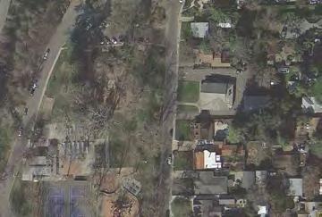
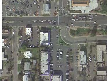
7 INTERSTATE City of Roseville: Douglas Boulevard Coffee Kiosk Harding Blvd NOT TO SCALE CALIFORNIA 80 Sunrise Ave Keehner Ave Donner Ave Folsom Rd Legend: Project Exhibit 1 Vicinity Map
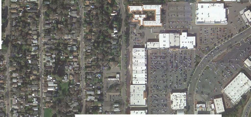
8 City of Roseville: Douglas Boulevard Coffee Kiosk Exhibit 2 Project Layout
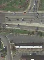
9 City of Roseville: Douglas Boulevard Coffee Kiosk NOT TO SCALE 1 Driveway is ingress only with project Alley Donner Ave Alley Folsom Rd Driveway Folsom Rd Keehner Ave # LEGEND Study Intersection Project Signalized Study Intersection Stop-controlled Approach Exhibit 3 Study Intersections, Traffic Control, and Lane Geometries
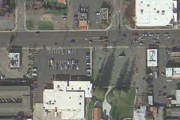
10 Driveway is ingress-only City of Roseville: Douglas Boulevard Coffee Kiosk Existing (2016) Existing (2016) plus Proposed Project NOT TO SCALE Alley Alley Donner Ave Alley Folsom Rd Driveway Folsom Rd Driveway Folsom Rd Keehner Ave LEGEND # Study Intersection Project ## Peak-Hour Volume Exhibit 4 Existing (2016) and Existing (2016) plus Proposed Project Peak-Hour Volumes


11 City of Roseville: Douglas Boulevard Coffee Kiosk NOT TO SCALE Ben Ezra Ave Legend: XX XX Project Site Existing AM Peak Volume AM Peak Project Trips Exhibit 5 Peak Hour Volumes for Local Roads
12 Douglas Boulevard Coffee Kiosk Traffic Evaluation Attachment A Traffic Count Data Sheets
13 City of Roseville All Vehicles & Uturns On Unshifted Nothing On Bank 1 National Data and Surveying Services (323) info@ndsdata.com File Name : Date : & Bet. Donner Ave and Folsom Rd 12/1/2016 Nothing On Bank 2 Unshifted Count = All Vehicles & Uturns Bet. Donner Ave and Folsom Rd Bet. Donner Ave and Folsom Rd Southbound Westbound Northbound Eastbound START TIME LEFT THRU RIGHT UTURNS APP.TOTAL LEFT THRU RIGHT UTURNS APP.TOTAL LEFT THRU RIGHT UTURNS APP.TOTAL LEFT THRU RIGHT UTURNS APP.TOTAL Uturns 6: : : : : : : : : : : : Grand Apprch % 10.0% 0.0% 90.0% 0.0% 0.0% 99.8% 0.1% 0.1% 0.0% 0.0% 0.0% 0.0% 0.7% 99.3% 0.0% 0.0% % 0.0% 0.0% 0.3% 0.0% 0.3% 0.0% 42.5% 0.1% 0.0% 42.6% 0.0% 0.0% 0.0% 0.0% 0.0% 0.4% 56.7% 0.0% 0.0% 57.1% 100.0% AM PEAK Bet. Donner Ave and Folsom Rd Bet. Donner Ave and Folsom Rd HOUR Southbound Westbound Northbound Eastbound START TIME LEFT THRU RIGHT UTURNS APP.TOTAL LEFT THRU RIGHT UTURNS APP.TOTAL LEFT THRU RIGHT UTURNS APP.TOTAL LEFT THRU RIGHT UTURNS APP.TOTAL Peak Hour Analysis From 07:30 to 08:30 Peak Hour For Entire Intersection Begins at 07:30 7: : : : Volume % App 0.0% 0.0% 100.0% 0.0% 0.0% 99.8% 0.2% 0.0% 0.0% 0.0% 0.0% 0.0% 0.4% 99.6% 0.0% 0.0% PHF
14 Turning Movement Volume Report Douglas & Folsom (332) Intersection: 63 12/1/2016 Date & Time N Left Thru Right App. S E W App. App. Left Thru Right Left Thru Right Left Thru Right 12/01/16 06:00-06: /01/16 06:15-06: /01/16 06:30-06: /01/16 06:45-06: /01/16 07:00-07: /01/16 07:15-07: /01/16 07:30-07: /01/16 07:45-07: /01/16 08:00-08: /01/16 08:15-08: /01/16 08:30-08: /01/16 08:45-08: : Approach%: 35% 29% 87% 91% 1% 8% 4% 95% 0% 1% 90% 7% Int. %: 0% 0% 0% 0% 17% 0% 1% 18% 1% 39% 0% 41% 0% 35% 3% 39% App. Int. 1
15 Turning Movement Volume Report Douglas & Keehner (332) Intersection: 64 12/1/2016 Date & Time N Left Thru Right App. E W App. App. Left Thru Right Left Thru Right Left Thru Right 12/01/16 06:00-06: /01/16 06:15-06: /01/16 06:30-06: /01/16 06:45-06: /01/16 07:00-07: /01/16 07:15-07: /01/16 07:30-07: /01/16 07:45-07: /01/16 08:00-08: /01/16 08:15-08: /01/16 08:30-08: /01/16 08:45-08: : Approach%: 20% 0% 79% 0% 98% 2% 13% 86% 0% 0% 0% 0% Int. %: 2% 0% 11% 14% 0% 45% 1% 45% 5% 34% 0% 39% 0% 0% 0% 0% App. Int. 1
16 Day: Tuesday Date: 5/15/2018 Prepared by NDS/ATD VOLUME Nevada Ave Bet. & Ben Ezra Ave City: Roseville Project #: CA18_7181_ AM Period TOTAL PM Period TOTAL 00: : : : : : : : : : : : : : : : : : : : : : : : : : : : : : : : : : : : : : : : : : : : : : : : : : : : : : : : : : : : : : : : : : : : : : : : : : : : : : : : : : : : : : : : : : : : : : : : TOTALS TOTALS SPLIT % 100.0% 31.3% SPLIT % 100.0% 68.7% AM Peak Hour 07:30 07:30 PM Peak Hour 16:45 16:45 AM Pk Volume PM Pk Volume Pk Hr Factor Pk Hr Factor Volume Volume Peak Hour 07:30 07: Peak Hour 16:45 16: Pk 7-9 Pk Volume Volume Pk Hr Factor Pk Hr Factor
17 Day: Wednesday Date: 5/16/2018 Prepared by NDS/ATD VOLUME Nevada Ave Bet. & Ben Ezra Ave City: Roseville Project #: CA18_7181_ AM Period TOTAL PM Period TOTAL 00: : : : : : : : : : : : : : : : : : : : : : : : : : : : : : : : : : : : : : : : : : : : : : : : : : : : : : : : : : : : : : : : : : : : : : : : : : : : : : : : : : : : : : : : : : : : : : : : TOTALS TOTALS SPLIT % 100.0% 37.1% SPLIT % 100.0% 62.9% AM Peak Hour 07:00 07:00 PM Peak Hour 17:00 17:00 AM Pk Volume PM Pk Volume Pk Hr Factor Pk Hr Factor Volume Volume Peak Hour 07:00 07: Peak Hour 17:00 17: Pk 7-9 Pk Volume Volume Pk Hr Factor Pk Hr Factor
18 Day: Thursday Date: 5/17/2018 Prepared by NDS/ATD VOLUME Nevada Ave Bet. & Ben Ezra Ave City: Roseville Project #: CA18_7181_ AM Period TOTAL PM Period TOTAL 00: : : : : : : : : : : : : : : : : : : : : : : : : : : : : : : : : : : : : : : : : : : : : : : : : : : : : : : : : : : : : : : : : : : : : : : : : : : : : : : : : : : : : : : : : : : : : : : : TOTALS TOTALS SPLIT % 100.0% 39.9% SPLIT % 100.0% 60.1% AM Peak Hour 07:00 07:00 PM Peak Hour 17:00 17:00 AM Pk Volume PM Pk Volume Pk Hr Factor Pk Hr Factor Volume Volume Peak Hour 07:00 07: Peak Hour 17:00 17: Pk 7-9 Pk Volume Volume Pk Hr Factor Pk Hr Factor
19 Day: Tuesday Date: 5/15/2018 Prepared by NDS/ATD VOLUME Donner Ave Bet. & Ben Ezra Ave City: Roseville Project #: CA18_7181_ AM Period TOTAL PM Period TOTAL 00: : : : : : : : : : : : : : : : : : : : : : : : : : : : : : : : : : : : : : : : : : : : : : : : : : : : : : : : : : : : : : : : : : : : : : : : : : : : : : : : : : : : : : : : : : : : : : : : TOTALS TOTALS SPLIT % 100.0% 37.8% SPLIT % 100.0% 62.2% AM Peak Hour 07:45 07:45 PM Peak Hour 15:45 15:45 AM Pk Volume PM Pk Volume Pk Hr Factor Pk Hr Factor Volume Volume Peak Hour 07:45 07: Peak Hour 16:00 16: Pk 7-9 Pk Volume Volume Pk Hr Factor Pk Hr Factor
20 Day: Wednesday Date: 5/16/2018 Prepared by NDS/ATD VOLUME Donner Ave Bet. & Ben Ezra Ave City: Roseville Project #: CA18_7181_ AM Period TOTAL PM Period TOTAL 00: : : : : : : : : : : : : : : : : : : : : : : : : : : : : : : : : : : : : : : : : : : : : : : : : : : : : : : : : : : : : : : : : : : : : : : : : : : : : : : : : : : : : : : : : : : : : : : : TOTALS TOTALS SPLIT % 100.0% 36.0% SPLIT % 100.0% 64.0% AM Peak Hour 07:45 07:45 PM Peak Hour 17:15 17:15 AM Pk Volume PM Pk Volume Pk Hr Factor Pk Hr Factor Volume Volume Peak Hour 07:45 07: Peak Hour 16:30 16: Pk 7-9 Pk Volume Volume Pk Hr Factor Pk Hr Factor
21 Day: Thursday Date: 5/17/2018 Prepared by NDS/ATD VOLUME Donner Ave Bet. & Ben Ezra Ave City: Roseville Project #: CA18_7181_ AM Period TOTAL PM Period TOTAL 00: : : : : : : : : : : : : : : : : : : : : : : : : : : : : : : : : : : : : : : : : : : : : : : : : : : : : : : : : : : : : : : : : : : : : : : : : : : : : : : : : : : : : : : : : : : : : : : : TOTALS TOTALS SPLIT % 100.0% 34.3% SPLIT % 100.0% 65.7% AM Peak Hour 08:15 08:15 PM Peak Hour 16:30 16:30 AM Pk Volume PM Pk Volume Pk Hr Factor Pk Hr Factor Volume Volume Peak Hour 07:45 07: Peak Hour 16:30 16: Pk 7-9 Pk Volume Volume Pk Hr Factor Pk Hr Factor
22 Day: Tuesday Date: 5/15/2018 Prepared by NDS/ATD VOLUME Ben Ezra Ave Bet. Donner Ave & Folsom Rd City: Roseville Project #: CA18_7181_ AM Period TOTAL PM Period TOTAL 00: : : : : : : : : : : : : : : : : : : : : : : : : : : : : : : : : : : : : : : : : : : : : : : : : : : : : : : : : : : : : : : : : : : : : : : : : : : : : : : : : : : : : : : : : : : : : : : : TOTALS TOTALS SPLIT % 64.5% 35.5% 37.9% SPLIT % 51.7% 48.3% 62.1% AM Peak Hour 08:00 10:00 08:00 PM Peak Hour 16:00 16:30 16:00 AM Pk Volume PM Pk Volume Pk Hr Factor Pk Hr Factor Volume Volume Peak Hour 08:00 07:30 08: Peak Hour 16:00 16:30 16: Pk 7-9 Pk Volume Volume Pk Hr Factor Pk Hr Factor
23 Day: Wednesday Date: 5/16/2018 Prepared by NDS/ATD VOLUME Ben Ezra Ave Bet. Donner Ave & Folsom Rd City: Roseville Project #: CA18_7181_ AM Period TOTAL PM Period TOTAL 00: : : : : : : : : : : : : : : : : : : : : : : : : : : : : : : : : : : : : : : : : : : : : : : : : : : : : : : : : : : : : : : : : : : : : : : : : : : : : : : : : : : : : : : : : : : : : : : : TOTALS TOTALS SPLIT % 67.0% 33.0% 35.8% SPLIT % 48.6% 51.4% 64.2% AM Peak Hour 08:00 11:15 08:00 PM Peak Hour 15:15 16:30 15:15 AM Pk Volume PM Pk Volume Pk Hr Factor Pk Hr Factor Volume Volume Peak Hour 08:00 07:45 08: Peak Hour 16:00 16:30 16: Pk 7-9 Pk Volume Volume Pk Hr Factor Pk Hr Factor
24 Day: Thursday Date: 5/17/2018 Prepared by NDS/ATD VOLUME Ben Ezra Ave Bet. Donner Ave & Folsom Rd City: Roseville Project #: CA18_7181_ AM Period TOTAL PM Period TOTAL 00: : : : : : : : : : : : : : : : : : : : : : : : : : : : : : : : : : : : : : : : : : : : : : : : : : : : : : : : : : : : : : : : : : : : : : : : : : : : : : : : : : : : : : : : : : : : : : : : TOTALS TOTALS SPLIT % 73.4% 26.6% 37.0% SPLIT % 54.5% 45.5% 63.0% AM Peak Hour 07:45 11:00 07:45 PM Peak Hour 14:00 17:30 17:30 AM Pk Volume PM Pk Volume Pk Hr Factor Pk Hr Factor Volume Volume Peak Hour 07:45 08:00 07: Peak Hour 16:45 17:00 16: Pk 7-9 Pk Volume Volume Pk Hr Factor Pk Hr Factor
25 Douglas Boulevard Coffee Kiosk Traffic Evaluation Attachment B Analysis Worksheets
26 Douglas Boulevard Coffee Kiosk Existing plus Proposed Project 1: & Project Dwy AM Peak Intersection Int Delay, s/veh 0.3 Movement EBL EBT WBT WBR SBL SBR Lane Configurations Traffic Vol, veh/h Future Vol, veh/h Conflicting Peds, #/hr Sign Control Free Free Free Free Stop Stop RT Channelized - None - None - None Storage Length Veh in Median Storage, # Grade, % Peak Hour Factor Heavy Vehicles, % Mvmt Flow Major/Minor Major1 Major2 Minor2 Conflicting Flow All Stage Stage Critical Hdwy Critical Hdwy Stg Critical Hdwy Stg Follow-up Hdwy Pot Cap-1 Maneuver Stage Stage Platoon blocked, % Mov Cap-1 Maneuver Mov Cap-2 Maneuver Stage Stage Approach EB WB SB HCM Control Delay, s HCM LOS A Minor Lane/Major Mvmt EBL EBT WBT WBR SBLn1 Capacity (veh/h) HCM Lane V/C Ratio HCM Control Delay (s) HCM Lane LOS B A HCM 95th %tile Q(veh) Kimley-Horn Synchro 9 Report HCM 2010 TWSC Page 1
27 Douglas Boulevard Coffee Kiosk Existing plus Proposed Project 2: Driveway/Folsom Rd & AM Peak Lane Group EBL EBT WBL WBT NBT SBL SBT SBR Lane Group Flow (vph) v/c Ratio Control Delay Queue Delay Delay Queue Length 50th (ft) Queue Length 95th (ft) Internal Link Dist (ft) Turn Bay Length (ft) Base Capacity (vph) Starvation Cap Reductn Spillback Cap Reductn Storage Cap Reductn Reduced v/c Ratio Intersection Summary Kimley-Horn Synchro 9 Report Queues Page 2
28 Douglas Boulevard Coffee Kiosk Existing plus Proposed Project 2: Driveway/Folsom Rd & AM Peak Movement EBL EBT EBR WBL WBT WBR NBL NBT NBR SBL SBT SBR Lane Configurations Traffic Volume (veh/h) Future Volume (veh/h) Number Initial Q (Qb), veh Ped-Bike Adj(A_pbT) Parking Bus, Adj Adj Sat Flow, veh/h/ln Adj Flow Rate, veh/h Adj No. of Lanes Peak Hour Factor Percent Heavy Veh, % Cap, veh/h Arrive On Green Sat Flow, veh/h Grp Volume(v), veh/h Grp Sat Flow(s),veh/h/ln Q Serve(g_s), s Cycle Q Clear(g_c), s Prop In Lane Lane Grp Cap(c), veh/h V/C Ratio(X) Avail Cap(c_a), veh/h HCM Platoon Ratio Upstream Filter(I) Uniform Delay (d), s/veh Incr Delay (d2), s/veh Initial Q Delay(d3),s/veh %ile BackOfQ(50%),veh/ln LnGrp Delay(d),s/veh LnGrp LOS D B B E B B E C B Approach Vol, veh/h Approach Delay, s/veh Approach LOS B B E C Timer Assigned Phs Phs Duration (G+Y+Rc), s Change Period (Y+Rc), s Max Green Setting (Gmax), s Max Q Clear Time (g_c+i1), s Green Ext Time (p_c), s Intersection Summary HCM 2010 Ctrl Delay 14.6 HCM 2010 LOS B Notes Kimley-Horn Synchro 9 Report HCM 2010 Signalized Intersection Summary Page 3
TRAFFIC IMPACT STUDY
 TRAFFIC IMPACT STUDY TERRE HAUTE CONVENTION CENTER WABASH AVENUE & 9 TH STREET TERRE HAUTE, INDIANA PREPARED FOR 8365 Keystone Crossing, Suite 201 Indianapolis, IN 46240 Phone: (317) 202-0864 Fax: (317)
Airline Road: is a two lane residential roadway adjacent to the west side of the proposed school site with a speed limit of 30 mph.
 HIGHLAND PARK ISD TRAFFIC IMPACT STUDY REPORT FOR PROPOSED HPISD ELEMENTARY SCHOOL SITE ON NORTHWEST HIGHWAY BETWEEN AIRLINE ROAD AND DURHAM IN THE CITY OF DALLAS, TEXAS PURPOSE OF STUDY The purpose of
WEBER ROAD RESIDENTIAL DEVELOPMENT Single Family Residential Project
 WEBER ROAD RESIDENTIAL DEVELOPMENT Single Family Residential Project WEBER ROAD RESIDENTIAL DEVELOPMENT TRAFFIC IMPACT STUDY TABLE OF CONTENTS 1.0 Executive Summary Page 2.0 Introduction 2.1 DEVELOPMENT
The Highline Development Traffic Impact Study
 The Highline Development Traffic Impact Study Columbia Falls, Montana Prepared For: TD&H Engineering 450 Corporate Drive, Suite 101 Kalispell, MT 59901 June, 2018 130 South Howie Street Helena, Montana
TRAFFIC IMPACT STUDY MANUFACTURING COMPANY
 TRAFFIC IMPACT STUDY For MANUFACTURING COMPANY Prepared For: Airway Heights, WA Prepared By: SUNBURST ENGINEERING, P. S. 4310 S. Ball Dr. Veradale, WA 99037 April, 2013 TRAFFIC IMP ACT STUDY Manufacturing
JEP John E. Jack Pflum, P.E. Consulting Engineering 7541 Hosbrook Road, Cincinnati, OH Telephone:
 JEP John E. Jack Pflum, P.E. Consulting Engineering 7541 Hosbrook Road, Cincinnati, OH 45243 Email: jackpflum1@gmail.com Telephone: 513.919.7814 MEMORANDUM REPORT Traffic Impact Analysis Proposed Soccer
Market Street PDP. Nassau County, Florida. Transportation Impact Analysis. VHB/Vanasse Hangen Brustlin, Inc. Nassau County Growth Management
 Transportation Impact Analysis Market Street PDP Nassau County, Florida Submitted to Nassau County Growth Management Prepared for TerraPointe Services, Inc. Prepared by VHB/Vanasse Hangen Brustlin, Inc.
TRAFFIC IMPACT STUDY. Platte Canyon Villas Arapahoe County, Colorado (Arapahoe County Case Number: Z16-001) For
 For") TRAFFIC IMPACT STUDY For Platte Canyon Villas Arapahoe County, Colorado (Arapahoe County Case Number: Z16-001) February 2015 Revised: August 2015 April 2016 July 2016 September 2016 Prepared for: KB Home
TRAFFIC IMPACT STUDY For Platte Canyon Villas Arapahoe County, Colorado (Arapahoe County Case Number: Z16-001) February 2015 Revised: August 2015 April 2016 July 2016 September 2016 Prepared for: KB Home
MEMORANDUM. The study area of the analysis was discussed with City staff and includes the following intersections:
 MEMORANDUM DATE: JULY 6, 2012 TO: FROM: RE: CC: MELANIE KNIGHT BRAD BYVELDS/ JENNIFER LUONG 1050 SOMERSET STREET PRELIMINARY TRAFFIC ANALYSIS OUR FILE NO. 111152 NEIL MALHOTRA The purpose of this memo
TRANSPORTATION IMPACT STUDY WHEELER STREET CLOSURE
 TRANSPORTATION IMPACT STUDY WHEELER STREET CLOSURE Village of Greene, Chenango County, New York Prepared for: VILLAGE OF GREENE 49 Genesee Street Greene, NY 13778 Prepared by: LARSON DESIGN GROUP 1000
April 10, Mr. Curt Van De Walle, City Manager City of Castle Hills 209 Lemonwood Drive Castle Hills, Texas 78213
 Mr. Curt Van De Walle, City Manager City of Castle Hills 209 Lemonwood Drive Castle Hills, Texas 78213 Subject: Revised Castle Hills BASIS Charter School Traffic Impact Analysis Review City of Castle Hills,
KAISER SOUTH NORTHERN VIRGINIA HUB TRAFFIC IMPACT STUDY PRINCE WILLIAM COUNTY, VIRGINIA TABLE OF CONTENTS. Section 2 BACKGROUND INFORMATION 12
 KAISER SOUTH NORTHERN VIRGINIA HUB TRAFFIC IMPACT STUDY PRINCE WILLIAM COUNTY, VIRGINIA TABLE OF CONTENTS Page EXECUTIVE SUMMARY 1 Purpose of Report and Study Objectives... 1 Site Location and Study Area...
CVS Derwood. Local Area Transportation Review
 CVS Derwood Montgomery County, Maryland May 27, 2016 Local Area Transportation Review Prepared for: JC Bar Properties, Inc. Steve Fleming, PE 415 Fallowfield Road, Suite 301 Camp Hill, Pennsylvania 17011
APPENDIX. Sutter Street Bicycle Lanes Stockton, CA January 2010
 APPENDIX reet Bicycle Lanes Stockton, CA January 2010 1. Traffic count locations 2. Turning movement counts o AM PEAK - El Dorado Street at Ingram Street o PM PEAK - El Dorado Street at Ingram Street o
PLAZA MEXICO RESIDENCES
 PLAZA MEXICO RESIDENCES TRAFFIC STUDY PREPARED FOR: 3000 E. IMPERIAL, LLC. 6940 Beach Boulevard, D-501 Buena Park, California 90621 PREPARED BY: OCTOBER 5, 2017 translutions the transportatio n solutions
ALTA VISTA COMMERCIAL/ RESIDENTIAL PROJECT
 ALTA VISTA COMMERCIAL/ RESIDENTIAL PROJECT TRAFFIC IMPACT ANALYSIS Prepared For: Paul Conzelman SC Development 2151 Michelson Drive, Suite 140 Irvine, CA 92612 Prepared By: 2030 Main Street, Suite 1200
TRAFFIC IMPACT STUDY FOR SOUTH BAY SALT POND RESTORATION PROJECT PHASE 2
 APPENDIX G TRAFFIC IMPACT STUDY FOR SOUTH BAY SALT POND RESTORATION PROJECT PHASE 2 South Bay Salt Pond Restoration Project Phase II May 2015 Draft Environmental Impact Statement/Report Traffic Impact
Travel Demand Management Plan
 Travel Demand Management Plan Tryg s & Apartment Building 8 West Lake Street Minneapolis, MN AUTHORIZED PROPERTY REPRESENTATIVE: By Dated: Mr. Johnny Carlson Trammell Crow Chicago Development, Inc. 5 South
LIC SR INTERCHANGE OPERATIONS STUDY
 LIC SR 16 18.20 - INTERCHANGE OPERATIONS STUDY Project Summary Location SR 16 & W. Church St. Interchange Newark, Ohio Licking County PID 99478 Study Sponsor ODOT District 5 Proposed Work Add Left Turn
DOLLAR GENERAL PROJECT FOCUSED TRAFFIC ANALYSIS (REVISED) May 20, 2015
 May 20, 2015") DOLLAR GENERAL PROJECT FOCUSED TRAFFIC ANALYSIS (REVISED) May 20, 2015 May 20, 2015 Mr. Dan Biswas, VP of Development CJS DEVELOPMENT II, LLC 5111 North Scottsdale Road, Suite 200 Scottsdale, CA 85250
DOLLAR GENERAL PROJECT FOCUSED TRAFFIC ANALYSIS (REVISED) May 20, 2015 May 20, 2015 Mr. Dan Biswas, VP of Development CJS DEVELOPMENT II, LLC 5111 North Scottsdale Road, Suite 200 Scottsdale, CA 85250
Focused Traffic Analysis for the One Lincoln Park Project
 September 15, 2015 Mr. Bill Johnson Coldwell Banker 511 Sir Francis Drake Boulevard Greenbrae, CA 94904 Focused Traffic Analysis for the One Lincoln Park Project Dear Mr. Johnson; As requested, W-Trans
Traffic Impact Study
 Traffic Impact Study Statham DRI One University Parkway Prepared for: Barrow County Prepared by: October 2012 Table of Contents Executive Summary i Section 1. Introduction 1 Project Description 1 Methodology
SUBJECT: SUMMARY OF FINDINGS. October 29, Mr. Carter Redish Carter Group Architects, Inc S. El Camino Real, Suite F San Clemente, CA 92672
 October 29, 2018 Mr. Carter Redish Carter Group Architects, Inc. 1810 S. El Camino Real, Suite F San Clemente, CA 92672 SUBJECT: CANYON STEEL FOCUSED TRAFFIC IMPACT ANALYSIS Dear Mr. Carter Redish: Urban
Table of Contents Introduction... 4 Study Area... 5
 Table of Contents Introduction... 4 Study Area... 5 Streets and s... 5 Traffic Volumes... 8 Recent and Anticipated Development... 10 Crash Analysis... 10 Projected Traffic Volumes... 11 Trip Generation...
Traffic Impact Analysis. for the STARBUCKS STORE. Located at 9900 BALBOA BOULEVARD. Submitted to CITY OF LOS ANGELES. January 2017.
 Traffic Impact Analysis for the STARBUCKS STORE Located at 9900 BALBOA BOULEVARD Submitted to CITY OF LOS ANGELES January 2017 Submitted By January 5, 2017 Ken A. Aitchison, P.E. Transportation Engineering
Signalized Intersections
 Signalized Intersections Kelly Pitera October 23, 2009 Topics to be Covered Introduction/Definitions D/D/1 Queueing Phasing and Timing Plan Level of Service (LOS) Signal Optimization Conflicting Operational
The Sunland Park flyover ramp is set to close the week of March 19 until early summer
 March 2, 2018 The Sunland Park flyover ramp is set to close the week of March 19 until early summer GO 10 is targeting the week of March 19 to close the Sunland Park Drive flyover entrance ramp to I 10
Appendix C Traffic Study
 Final Environmental Impact Statement Appendix C Traffic Study Schofield Generating Station Project, Hawaii October 2015 C-1 Final Environmental Impact Statement This page intentionally left blank. Schofield
NATHAN HALE HIGH SCHOOL PARKING AND TRAFFIC ANALYSIS. Table of Contents
 Parking and Traffic Analysis Seattle, WA Prepared for: URS Corporation 1501 4th Avenue, Suite 1400 Seattle, WA 98101-1616 Prepared by: Mirai Transportation Planning & Engineering 11410 NE 122nd Way, Suite
MEMORANDUM. Trip Generation Analysis
 MEMORANDUM To: RMC Architects From: Matthew Palmer, PE Subject: Trip Generation, Parking Analysis & Level of Service Project: Port of Everett, GTC #13-053 Date: August 25, 2014 The trip generation and
FINAL Traffic Report for the Proposed Golden Valley Road and Newhall Ranch Road Projects in the City of Santa Clarita, California May 5, 2005
 FINAL Traffic Report for the Proposed Golden Valley Road and Newhall Ranch Road Projects in the City of Santa Clarita, California May 5, 2005 Prepared For: EDAW, Inc. 1420 Kettner Boulevard, Suite 620
US 169/I-70 North Loop Planning & Environmental Linkages Study
 US 169/I-70 North Loop Planning & Environmental Linkages Study VISSIM Calibration Document Draft April 13, 2018 Page i Table of Contents 1. Overview... 1 2. Data Types... 2 3. Model Parameter Adjustments...
Prepared for. 3D/International, Inc West Loop South, Suite 400 Houston, Texas November 2006
 DRAFT TRAFFIC IMPACT STUDY FOR PHASED DEVELOPMENT OF TAMU CC Prepared for 3D/International, Inc. 1900 West Loop South, Suite 400 Houston, Texas 77027 November 2006 Interim Review Only Document Incomplete:
Appendix I: Traffic Study
 City of Fontana Sierra Lakes Commerce Center Draft EIR Appendix I: Traffic Study FirstCarbon Solutions H:\Client (PN JN)\0144\01440050\EIR\1 ADEIR\01440050 Sec99 99 Appendix Dividers.doc THIS PAGE INTENTIONALLY
6711 LEE HIGHWAY TRAFFIC IMPACT STUDY ARLINGTON, VIRGINIA
 6711 TRAFFIC IMPACT STUDY ARLINGTON, VIRGINIA Prepared for: NVR, Inc. Prepared by: Wells + Associates, Inc. Michael J. Workosky, PTP, TOPS, TSOS John J. Andrus William L. Zeid, PE 703.917.6620 May 4, 2017
MADISON, WI STONE HOUSE DEVELOPMENT 1000 E. WASHINGTON AVENUE REDEVELOPMENT TRANSPORTATION STUDY DECEMBER 14, 2015
 MADISON, WI STONE HOUSE DEVELOPMENT 1000 E. WASHINGTON AVENUE REDEVELOPMENT TRANSPORTATION STUDY DECEMBER 14, 2015 TABLE OF CONTENTS... 3 Proposed Development... 3 Methodology... 3 Phase 1 Development...
MnDOT Method for Calculating Measures of Effectiveness (MOE) From CORSIM Model Output
 From CORSIM Model Output") MnDOT Method for Calculating Measures of Effectiveness (MOE) From CORSIM Model Output Rev. April 29, 2005 MnDOT Method for Calculating Measures of Effectiveness (MOE) From CORSIM Model Output Table of
MnDOT Method for Calculating Measures of Effectiveness (MOE) From CORSIM Model Output Rev. April 29, 2005 MnDOT Method for Calculating Measures of Effectiveness (MOE) From CORSIM Model Output Table of
CE351 Transportation Systems: Planning and Design
 CE351 Transportation Systems: Planning and Design TOPIC: Level of Service (LOS) at Traffic Signals 1 Course Outline Introduction to Transportation Highway Users and their Performance Geometric Design Pavement
Appendix C Final Methods and Assumptions for Forecasting Traffic Volumes
 Fairview Ave. and Main St. Improvements and Local Streets Plan Appendices Ada County Highway District Appendix C Final Methods and Assumptions for Forecasting Traffic Volumes January 3, 207 Appendices
CHAPTER 3. CAPACITY OF SIGNALIZED INTERSECTIONS
 CHAPTER 3. CAPACITY OF SIGNALIZED INTERSECTIONS 1. Overview In this chapter we explore the models on which the HCM capacity analysis method for signalized intersections are based. While the method has
FINAL REPORT. City of Toronto. Contract Project No: B
 City of Toronto SAFETY IMPACTS AND REGULATIONS OF ELECTRONIC STATIC ROADSIDE ADVERTISING SIGNS TECHNICAL MEMORANDUM #2B BEFORE/AFTER COLLISION ANALYSIS AT MID-BLOCK LOCATIONS FINAL REPORT 3027 Harvester
S.170 th Street Micro-Simulation Seattle-Tacoma International Airport Port of Seattle/Aviation Planning
 Seattle-acoma International Airport Port of Seattle/Aviation Planning Port of Seattle PO OF SEAE Aviation Planning Airport Operations January 24, 2013 Summary he Port is planning to relocate the cell phone
Metro Emergency Security Operations Center (ESOC) 410 Center Street City of Los Angeles
 410 Center Street City of Los Angeles") Metro Emergency Security Operations Center (ESOC) 410 Center Street City of Los Angeles Traffic Study August 31, 2015 AECOM 515 South Flower Street, 4 th Floor Los Angeles, CA 90071 Job Number: 60323255
Metro Emergency Security Operations Center (ESOC) 410 Center Street City of Los Angeles Traffic Study August 31, 2015 AECOM 515 South Flower Street, 4 th Floor Los Angeles, CA 90071 Job Number: 60323255
TRANSPORTATION AND TRAFFIC ANALYSIS REPORT
 Square One Drive Extension Municipal Class Environmental Assessment Environmental Study Report Appendix B Transportation and Traffic Analysis Report TRANSPORTATION AND TRAFFIC ANALYSIS REPORT FINAL DRAFT
TRAFFIC STUDY FOR THE GAFFEY POOL PROJECT LOS ANGELES, CALIFORNIA CITY OF LOS ANGELES, BUREAU OF ENGINEERING OCTOBER 2013 PREPARED FOR PREPARED BY
 TRAFFIC STUDY FOR THE GAFFEY POOL PROJECT LOS ANGELES, CALIFORNIA OCTOBER 2013 PREPARED FOR CITY OF LOS ANGELES, BUREAU OF ENGINEERING PREPARED BY DRAFT TRAFFIC STUDY FOR THE GAFFEY POOL PROJECT October
Critchfield Rd / SR-129
 NOVEMBER 27, 2017 Critchfield Rd / SR-129 Intersection Safety Study Alternatives Report CRITCHFIELD INTERSECTION SAFETY STUDY Contents Introduction...1 Purpose...2 Existing Conditions...2 Proposed Alternatives...2
Subject: Desert Palisades Specific Plan - Tram Way Access Sight Distance
 Endo Engineering Traffic Engineering Air Quality Studies Noise Assessments July 13, 2015 Mr. Ed Freeman Pinnacle View, LLC P.O. Box 1754 Lake Oswego, OR 97035-0579 Subject: Desert Palisades Specific Plan
Approved Corrections and Changes for the Highway Capacity Manual 2000
 Approved Corrections and Changes for the Highway Capacity Manual 2000 Updated 7/8/2005 Previous update 2/27/2004 TRB Committee AHB40, Highway Capacity and Quality of Service Unless stated otherwise, corrections
FARM 1065 PORTION 1, ATLANTIS TRAFFIC IMPACT ASSESSMENT
 FARM 1065 PORTION 1, ATLANTIS TRAFFIC IMPACT ASSESSMENT February 2018 FIRST ISSUE Prepared by: JG AFRIKA (PTY) LTD Branch: Cape Town PO Box 38561 Postal code: 7430 Telephone: 021 530 1800 Email: wink@
Preliminary Access and Circulation Evaluation of the Rossmoor Town Center Project in Walnut Creek, CA
 Attachment 7 April 23, 2015 Dwight Belden Chief Operating Officer Citivest Commercial Investments, LLC 4340 Von Karman Avenue, Suite 110 Newport Beach, CA 92660 Subject: Preliminary Access and Circulation
Design Priciples of Traffic Signal
 Design Priciples of Traffic Signal Lecture Notes in Transportation Systems Engineering Prof. Tom V. Mathew Contents 1 Overview 1 2 Definitions and notations 2 3 Phase design 3 3.1 Two phase signals.................................
2129 NORTH MAIN STREET HOTE PROJECT ULI SHARED PARKING STUDY City of Santa Ana, California
 2129 NORTH MAIN STREET HOTE PROJECT ULI SHARED PARKING STUDY City of Santa Ana, California Prepared for: NET DEVELOPMENT COMPANY 3130 Airway Avenue Costa Mesa, CA 92626 Prepared by: RK ENGINEERING GROUP,
I-10 East at Redd closes for 24 hours this Sunday, Feb 11. Then, I-10 West at Resler closes for 27 hours on Feb 25
 NEWS RELEASE a TxDOT Project For immediate release EL PASO DISTRICT Jennifer Wright (915) 790-4340 Jennifer.Wright3@txdot.gov February 9, 2018 I-10 East at Redd closes for 24 hours this Sunday, Feb 11
1 h. Page 1 of 12 FINAL EXAM FORMULAS. Stopping Sight Distance. (2 ) N st U Where N=sample size s=standard deviation t=z value for confidence level
 N st U Where N=sample size s=standard deviation t=z value for confidence level") Page 1 of 12 FINAL EXAM FORMULAS Stopping Sight Distance 2 2 V V d 1.47Vt 1.075 i f a 2 2 Vi Vf d 1.47Vt 30( f 0.01 G) Where d = distance (ft) V = speed (mph) t = time (sec) a=deceleration rate (ft/sec
Page 1 of 12 FINAL EXAM FORMULAS Stopping Sight Distance 2 2 V V d 1.47Vt 1.075 i f a 2 2 Vi Vf d 1.47Vt 30( f 0.01 G) Where d = distance (ft) V = speed (mph) t = time (sec) a=deceleration rate (ft/sec
Date: April 3, 2018 Revised May 15, Project #: Re: Burlington Mall Retail Collection Transportation Evaluation
 To: Chuck Schneider Burlington S&S, LLC 225 West Washington Street Indianapolis, IN 46204 From: Patrick Dunford, P.E. Senior Project Manager Date: April 3, 2018 Revised May 15, 2018 Project #: 13482.01
FY 2010 Continuing i Planning Program Product Report. Local Transportation and Traffic Data. Wood-Washington-Wirt Interstate Planning Commission
 FY 2010 Continuing i Planning Program Product Report Local Transportation and Traffic Data Travel Time and Delay Data for Belpre and Marietta, Ohio Wood-Washington-Wirt Interstate Planning Commission CONTINUING
HALFF 16196? TRAFFIC MANAGEMENT PLAN. Richardson ISD Aikin Elementary School Dallas, Texas North Bowser Road Richardson, Texas 75081
 30280 16196? TRAFFIC MANAGEMENT PLAN Exhibit 572B Aikin Elementary School Planned Development District No. 572 Approved City Plan Commission October20, 2016 July 12, 2016 Prepared for HALFF AVO 31586 PHO1
January 12, Mr. Ryan Granger TMGB Wilson, LLC 2221 Health Drive SW, Suite 2200 Wyoming, Michigan 49519
 January 12, 2018 Mr. Ryan Granger TMGB Wilson, LLC 2221 Health Drive SW, Suite 2200 Wyoming, Michigan 49519 Re: Proposed Reserve at Rivertown Mixed-Use Development Updated Trip Generation and Site Driveway
WOODRUFF ROAD CORRIDOR ORIGIN-DESTINATION ANALYSIS
 2018 WOODRUFF ROAD CORRIDOR ORIGIN-DESTINATION ANALYSIS Introduction Woodruff Road is the main road to and through the commercial area in Greenville, South Carolina. Businesses along the corridor have
Planning Commission Staff Report
 Planning Commission Staff Report April 7, 2016 PROJECT: Dutch Bros Coffee at Sheldon FILE: EG-15-042 REQUEST: Conditional Use Permit (CUP) and Major Design Review Amendment (DR) LOCATION: 8821, 8829, 8835,
MEMORANDUM (DRAFT) DRAFT
 DRAFT") 117 Commercial St. NE, Suite 310 Salem, OR 97301 503.391.8773 www.dksassociates.com MEMORANDUM (DRAFT) DATE: February 15, 2017 TO: FROM: SUBJECT: Alex Dupey, MIG Scott Mansur, PE, PTOE; Garth Appanaitis,
117 Commercial St. NE, Suite 310 Salem, OR 97301 503.391.8773 www.dksassociates.com MEMORANDUM (DRAFT) DATE: February 15, 2017 TO: FROM: SUBJECT: Alex Dupey, MIG Scott Mansur, PE, PTOE; Garth Appanaitis,
CITY OF MINOT SNOW REMOVAL PLAN November 2017
 CITY OF MINOT SNOW REMOVAL PLAN November 2017 1.0 GENERAL This plan has been written to provide information regarding snow removal procedures and policies. The plan provides guidance, while maintaining
Appendixx C Travel Demand Model Development and Forecasting Lubbock Outer Route Study June 2014
 Appendix C Travel Demand Model Development and Forecasting Lubbock Outer Route Study June 2014 CONTENTS List of Figures-... 3 List of Tables... 4 Introduction... 1 Application of the Lubbock Travel Demand
PW 001 SNOW REMOVAL AND SANDING FOR ROADWAYS AND SIDEWALKS October 6, 2014 (#223-14) Original October 19, 2015; October 15, 2018 Public Works
 Original October 19, 2015; October 15, 2018 Public Works") Policy Statement: The Village of Kitscoty will provide snow and ice control on municipal streets and sidewalks according to determined priorities. Purpose: To provide direction and information to employees
Policy Statement: The Village of Kitscoty will provide snow and ice control on municipal streets and sidewalks according to determined priorities. Purpose: To provide direction and information to employees
City of Camrose Winter Road Maintenance Policy
 City of Camrose Winter Road Maintenance Policy The purpose of this policy is to outline the level of service that the City of Camrose delivers regarding the maintenance of roads in winter conditions. 1.
TRAFFIC ALERT FOR WEEK OF February 4 8, 2008
 TRAFFIC ALERT FOR WEEK OF February 4 8, 2008 Highway work zones in the Staunton District The following is a list of highway work that might affect traffic in the Staunton transportation district during
Control Delay at Signalized Diamond Interchanges Considering Internal Queue Spillback Paper No
 Publish Information: Xu, H., H. Liu, and Z. Tian (00). Control Delay at Signalized Interchanges Considering Internal Queue Spillback. Journal of Transportation Research Record, No.73, 3 3. Control Delay
CONTINUING PLANNING PROGRAM LOCAL TRANSPORTATION AND TRAFFIC DATA PRODUCT REPORT [OH Corridors]
![CONTINUING PLANNING PROGRAM LOCAL TRANSPORTATION AND TRAFFIC DATA PRODUCT REPORT [OH Corridors]](/thumbs/94/120123757.jpg "CONTINUING PLANNING PROGRAM LOCAL TRANSPORTATION AND TRAFFIC DATA PRODUCT REPORT [OH Corridors]") CONTINUING PLANNING PROGRAM LOCAL TRANSPORTATION AND TRAFFIC DATA PRODUCT REPORT [OH Corridors] Travel Time and Delay Analysis for Belpre (OH) and Marietta (OH) Fiscal Year 2009 Report WOOD WASHINGTON
CONTINUING PLANNING PROGRAM LOCAL TRANSPORTATION AND TRAFFIC DATA PRODUCT REPORT [OH Corridors] Travel Time and Delay Analysis for Belpre (OH) and Marietta (OH) Fiscal Year 2009 Report WOOD WASHINGTON
CITY OF MINOT SNOW REMOVAL PLAN October 2018
 CITY OF MINOT SNOW REMOVAL PLAN October 2018 1.0 GENERAL This plan has been written to provide information regarding snow removal procedures and policies. The plan provides guidance, while maintaining
CHAPTER 3 TRANSPORTATION
 CHAPTER 3 TRANSPORTATION This chapter presents information on transportation impacts of Section 2 of the Project that have changed from those identified in the published Westside Subway Extension Final
North Carolina s First Quadrant Left: History and Lessons Learned
 North Carolina s First Quadrant Left: History and Lessons Learned Michael P. Reese, P.E. (Corresponding Author) Congestion Management Section Project Engineer North Carolina Department of Transportation
Roundabout Level of Service
 Roundabout Level of Service Rahmi Akçelik Director Akcelik & Associates Pty Ltd email: rahmi.akcelik@sidrasolutions.com web: www.sidrasolutions.com 8 January 2009 Contents 1. Introduction... 1 2. Fundamental
ADAPTIVE SIGNAL CONTROL IV
 ADAPTIVE SIGNAL CONTROL IV Evaluation of the Adaptive Traffic Control System in Park City, Utah Dr. Peter T. Martin Associate Professor Aleksandar Stevanovic Research Associate Ivana Vladisavljevic Research
Expanding the GSATS Model Area into
 Appendix A Expanding the GSATS Model Area into North Carolina Jluy, 2011 Table of Contents LONG-RANGE TRANSPORTATION PLAN UPDATE 1. Introduction... 1 1.1 Background... 1 1.2 Existing Northern Extent of
Trip Generation Study: A 7-Eleven Gas Station with a Convenience Store Land Use Code: 945
 Trip Generation Study: A 7-Eleven Gas Station with a Convenience Store Land Use Code: 945 Introduction The Brigham Young University Institute of Transportation Engineers student chapter (BYU ITE) completed
North Carolina s First Quadrant Left: History and Lessons Learned
 0 0 0 North Carolina s First Quadrant Left: History and Lessons Learned Michael P. Reese, P.E. (Corresponding Author) Congestion Management Section Project Engineer North Carolina Department of Transportation
Impact of Day-to-Day Variability of Peak Hour Volumes on Signalized Intersection Performance
 Impact of Day-to-Day Variability of Peak Hour Volumes on Signalized Intersection Performance Bruce Hellinga, PhD, PEng Associate Professor (Corresponding Author) Department of Civil and Environmental Engineering,
CHAPTER 2. CAPACITY OF TWO-WAY STOP-CONTROLLED INTERSECTIONS
 CHAPTER 2. CAPACITY OF TWO-WAY STOP-CONTROLLED INTERSECTIONS 1. Overview In this chapter we will explore the models on which the HCM capacity analysis method for two-way stop-controlled (TWSC) intersections
City of Hermosa Beach Beach Access and Parking Study. Submitted by. 600 Wilshire Blvd., Suite 1050 Los Angeles, CA
 City of Hermosa Beach Beach Access and Parking Study Submitted by 600 Wilshire Blvd., Suite 1050 Los Angeles, CA 90017 213.261.3050 January 2015 TABLE OF CONTENTS Introduction to the Beach Access and Parking
I-95/I-85 INTERCHANGE ROADWAY SAFETY ASSESSMENT
 FINAL REPORT I-95/I-85 INTERCHANGE ROADWAY SAFETY ASSESSMENT Prepared for: Prepared by: 117306012.B MARCH 2013 Final Report March 2013 I-95/I-85 Interchange ROADWAY SAFETY ASSESSMENT Prepared for: Prepared
1.0 INTRODUCTION AND SUMMARY...
 TABLE OF CONTENTS 1.0 INTRODUCTION AND SUMMARY... 1 1.1 Purpose and Study Objective... 1 1.2 Executive Summary... 1 2.0 ROADWAY CONDITIONS... 5 2.1 Granville Parkway (South Intersection)... 8 2.2 Tuscany
CITY OF MINOT SNOW REMOVAL PLAN JANUARY 2015
 CITY OF MINOT SNOW REMOVAL PLAN JANUARY 2015 1.0 GENERAL This plan has been written to provide information regarding snow removal procedures and policies. The plan provides guidance, while maintaining
Signalized Intersection Delay Models
 Chapter 35 Signalized Intersection Delay Models 35.1 Introduction Signalized intersections are the important points or nodes within a system of highways and streets. To describe some measure of effectiveness
Automated Delay Estimation at Signalized Intersections: Phase I Concept and Algorithm Development
 Brigham Young University BYU ScholarsArchive All Theses and Dissertations 2011-03-16 Automated Delay Estimation at Signalized Intersections: Phase I Concept and Algorithm Development Taylor R. Forbush
US 20 Highway Safety Study
 US 20 Highway Safety Study Corvallis City Limits to Springhill Road, Albany Prepared for Prepared by December 2016 US 20 HIGHWAY SAFETY STUDY FINAL REPORT Benton County, Oregon Prepared for: Oregon Department
St. Tammany: Transportation Systems Management Study (Covington) RPC Project No. (LA21-COV) State Project No F.A.P. No.
 RPC Project No. (LA21-COV) State Project No F.A.P. No.") St. Tammany: Transportation Systems Management Study (Covington) RPC Project o. (LA21-COV) State Project o. 700-52-0197 F.A.P. o. P-5208(514) LA 21 (Boston Street) Lee Lane to ew Hampshire Street Prepared
St. Tammany: Transportation Systems Management Study (Covington) RPC Project o. (LA21-COV) State Project o. 700-52-0197 F.A.P. o. P-5208(514) LA 21 (Boston Street) Lee Lane to ew Hampshire Street Prepared
Traffic flow theory involves the development of mathematical relationships among
 CHAPTER 6 Fundamental Principles of Traffic Flow Traffic flow theory involves the development of mathematical relationships among the primary elements of a traffic stream: flow, density, and speed. These
Final City of Colusa STREETS & ROADWAYS MASTER PLAN. October J Street Suite 390 Sacramento, CA 95814
 Final City of Colusa STREETS & ROADWAYS MASTER PLAN October 2009 660 J Street Suite 390 Sacramento, CA 95814 TABLE OF CONTENTS I. INTRODUCTION... 1 Report Organization...1 II. ANALYSIS METHODOLOGY... 2
Freeway Work Zone Lane Capacity
 Freeway Work Zone Lane Capacity Thomas Notbohm, P.E. Wisconsin Department of Transportation Thomas.Notbohm@dot.state.wi.us Alex Drakopoulos Department of Civil & Environmental Engineering Marquette University,
SHORT NIGHTTIME WATER SHUTDOWN TO OCCUR IN EARLY HOURS OF MAY 29
 Thank you for your interest in the Center City Connector Streetcar. In this weekly update, you ll find information about ongoing construction for the 1st phase of utility work in Pioneer Square. UPDATES
California Urban Infill Trip Generation Study. Jim Daisa, P.E.
 California Urban Infill Trip Generation Study Jim Daisa, P.E. What We Did in the Study Develop trip generation rates for land uses in urban areas of California Establish a California urban land use trip
6 th Line Municipal Class Environmental Assessment
 6 th Line Municipal Class Environmental Assessment County Road 27 to St John s Road Town of Innisfil, ON September 6, 2016 APPENDIX L: TRAVEL DEMAND FORECASTING MEMORANDUM Accessible formats are available
Traffic signal design-ii
 CHAPTER 4. TRAFFIC SIGNAL DESIGN-II NPTEL May 3, 007 Chapter 4 Traffic signal design-ii 4.1 Overview In the previous chapter, a simple design of cycle time was discussed. Here we will discuss how the cycle
CITY OF NEW LONDON WINTER ROAD & SIDEWALK MAINTENANCE POLICY
 CITY OF NEW LONDON WINTER ROAD & SIDEWALK MAINTENANCE POLICY GENERAL The purpose of this policy is to set up acceptable procedures and policies for the winter maintenance of public areas in the City of
III. FORECASTED GROWTH
 III. FORECASTED GROWTH In order to properly identify potential improvement projects that will be required for the transportation system in Milliken, it is important to first understand the nature and volume
APPENDIX IV MODELLING
 APPENDIX IV MODELLING Kingston Transportation Master Plan Final Report, July 2004 Appendix IV: Modelling i TABLE OF CONTENTS Page 1.0 INTRODUCTION... 1 2.0 OBJECTIVE... 1 3.0 URBAN TRANSPORTATION MODELLING
Appendix B.1 EMME Model Calibration Memo
 Appendix B.1 EMME Model Calibration Memo itrans 144 Front Street West, Suite 655 Toronto, ON M5J 2L7 Tel: (416) 847-0005 Fax: (905) 882-1557 www.hdrinc.com www.itransconsulting.com File: 2.0 Memorandum
A Study of Red Light Cameras in Kansas City, MO
 A Study of Red Light s in Kansas City, MO Prepared by the Special Operations Division Executive Summary This paper will analyze the crash data for the 29 red light cameras located in 17 intersections in
VHD Daily Totals. Population 14.5% change. VMT Daily Totals Suffolk 24-hour VMT. 49.3% change. 14.4% change VMT
 6.9 Suffolk 6-54 VMT Population and Travel Characteristics Population 14.5% change 2014 1,529,202 VHD Daily Totals 2014 251,060 49.3% change 2040 1,788,175 2040 374,850 VMT Daily Totals 2014 39,731,990
CHAPTER 5 DELAY ESTIMATION FOR OVERSATURATED SIGNALIZED APPROACHES
 CHAPTER 5 DELAY ESTIMATION FOR OVERSATURATED SIGNALIZED APPROACHES Delay is an important measure of effectiveness in traffic studies, as it presents the direct cost of fuel consumption and indirect cost