noaa fisheries service
|
|
|
- Silas Cobb
- 5 years ago
- Views:
Transcription
 noaa fisheries service Mandatory speed restrictions of 10 knots or less are required in Seasonal Management Areas along the U.S. East Coast during times when right whales are likely to be present.")

1 Science, Service, Stewardship Compliance Guide for Right Whale Ship Strike Reduction Rule (50 CFR ) noaa fisheries service Mandatory speed restrictions of 10 knots or less are required in Seasonal Management Areas along the U.S. East Coast during times when right whales are likely to be present. The purpose of this regulation is to reduce the likelihood of deaths and serious injuries to these endangered whales that result from collisions with ships. Attention: All vessels greater than or equal to 65 ft (19.8 m) in overall length and subject to the jurisdiction of the United States and all vessels greater than or equal to 65 ft in overall length entering or departing a port or place subject to the jurisdiction of the United States. You must slow to speeds of 10 knots or less in Seasonal Management Areas Northeast U.S. Seasonal Management Areas Feeding Areas NOAA Vessels may operate at a speed greater than 10 knots only if necessary to maintain a safe maneuvering speed in an area where conditions severely restrict vessel maneuverability as determined by the pilot or master. If a deviation from the 10 knot speed restriction is necessary, the following information must be entered into the logbook: - Reasons for deviation - Speed at which vessel is operated - Latitude and longitude at time of deviation - Time and duration of deviation - Master of the vessel shall sign and date the logbook entry Page 1 of 2 Feeding Areas Cape Cod Bay Off Race Point Great South Channel January 1 - May 15 March 1 - April 30 April 1 - July 31 Includes all waters of Waters Bounded by: Waters Bounded by: Cape Cod Bay with 42º04'56.5"N 070º12'W 42º30'N, 069º45'W Northern Boundary of 42º12'N, 070º12'W 42º30'N, 067º27'W 42º04'56.5"N, 070º12'W to 42º12'N, 070º30'W 42º09'N, 067º08'24"W 42º12'N, 070º12'W 42º30'N, 070º30'W 41º00'N, 069º05'W then due west back to shore. 42º30'N, 069º45'W 41º40'N, 069º45'W 41º40'N, 069º45'W then back to starting pt. then due west back to shore. The rule does not apply to waters inshore of COLREGS lines. U.S. Department of Commerce National Oceanic and Atmospheric Administration National Marine Fisheries Service

: 38º52'27.4\"N 075º01'32.1\"W -Entrance to the Chesapeake Bay (Ports of Hampton Roads and Baltimore): 37º00'36.9\"N 075º57'50.")

2 Science, Service, Stewardship Migratory Route November 1 through April 30 Vessel speed is restricted in the following areas: Block Island Sound waters bounded by: 40º51'53.7" N 070º36'44.9" W 41º20'14.1" N 070º49'44.1" W 41º04'16.7" N 071º51'21.0" W 40º35'56.5" N 071º38'25.1" W then back to starting point. Within a 20-nm (37 km) radius of the following (as measured seaward from the COLREGS lines): -Ports of New York/New Jersey: 40º29'42.2"N 073º55'57.6"W -Entrance to the Delaware Bay (Ports of Philadelphia and Wilmington): 38º52'27.4"N 075º01'32.1"W -Entrance to the Chesapeake Bay (Ports of Hampton Roads and Baltimore): 37º00'36.9"N 075º57'50.5"W -Ports of Morehead City and Beaufort, NC: 34º41'32.0"N '08.3"W Within a continuous area 20 nm from shore between Wilmington, NC, to Brunswick, GA, bounded by the following: Point Latitude Longitude A 34º10'30"N 077º49'12"W B 33º56'42"N 077º31'30"W C 33º36'30"N 077º47'06"W D 33º28'24"N 078º32'30"W E 32º59'06"N 078º50'18"W F 31º50'00"N 080º33'12"W G 31º27'00"N 080º51'36"W and west back to the shore. Mid-Atlantic U.S. Seasonal Management Areas Migratory Route & Calving Grounds November 1 through April 30 Southeast U.S. Seasonal Management Area Calving and Nursery Grounds November 15 through April 15 Calving and Nursery Grounds November 15 through April 15 Vessel speed is restricted in the area bounded to the north by latitude 31º27'N; to the south by latitude 29º45'N; to the east by longitude 080º51'36"W. For more information, visit: Right Whale Ship Strike Reduction Rule expires on December 9, 2013 Page 2 of 2 The rule does not apply to waters inshore of COLREGS lines. Voluntary Dynamic Management Areas (DMAs) may also be established by NOAA Fisheries Service. Mariners are encouraged to avoid these areas or reduce speeds to 10 knots or less while transiting through these areas. NOAA Fisheries Service will announce DMAs to mariners through its customary maritime communication media. This serves as NOAA's small entity compliance guide. OMB Control # U.S. Department of Commerce National Oceanic and Atmospheric Administration National Marine Fisheries Service

3 Right Whale Mandatory Ship Reporting System All commercial ships of 300 gross tons and greater are required to report in when they enter either of two designated right whale reporting areas along the U.S. East Coast. All ships equipped with INMARSAT C must report in IMO standard format as provided in the table below. For further information on reporting procedures please consult 33 CFR Part 169, the Coast Pilot, or the Mandatory Ship Reporting (MSR) System web site at: Mandatory Reporting Requirements: (Report to: rightwhale.msr@noaa.gov or Telex: ) Paragraph Function Information Required System Name Area Identifier Reporting system area name (WHALESNORTH). M INMARSAT Number 9-digit vessel INMARSAT number. A Ship Vessel name and call sign. B Date, time, and month 6-digit group giving day of month and time, single letter indicating time zone, and three letters of report indicating month. E True course 3-digit number indicating true course. F Speed in knots and tenths 3-digit group indicating knots and tenths. H Date, time, and point of entry into system WHALESNORTH BOUNDARY The area coordinates (NAD 83) are as follows: from a point on Cape Ann, Massachusetts at N, W; then northeast to N, W; then southeast to N, W; then south to N, W; then west to N, W; then northwest to N, W, then west to N, W; and then along the Massachusetts shoreline of Cape Cod Bay and Massachusetts Bay back to the point on Cape Ann at N, W. Date and time expressed as in (B) and latitude and longitude expressed as a four digit group giving latitude, the letter N indicating north, followed by a /, a five digit group giving longitude, and the letter W indicating west. I Destination and ETA Name of port and arrival time expressed as in (B). L Route information and speed Route information should be reported as direct rhumbline to port (RL) and intended speed or a series of way points (WP). Vessels reporting waypoints should include latitude and longitude, expressed as in (H), and intended speed between waypoints. For vessels transiting within a traffic separation scheme (TSS), give only the WP on entry and departure of TSS. WHALESNORTH (operates year round) EXAMPLE REPORT: Please follow the format exactly as outlined below. WHALESNORTH// M/ // A/CALYPSO/NRUS// B/031401Z APR// E/345// F/15.5// H/031410Z APR/4104N/06918W// I/BOSTON/032345Z APR// L/WP/4104N/06918W/15.5// L/WP/4210N/06952W/15.5// L/WP/4230N/07006W/15.5// NOAA Chart #13009 *Vessels not equipped with INMARSAT C should still report via alternate satellite communications equipment to rightwhale.msr@noaa.gov or Telex: *Vessels unable to use satellite communications equipment should contact the U.S. Coast Guard Communication Area Master Station, Chesapeake, VA via published voice frequencies on 2182 khz, 4125 khz, 6215 khz, 8291 khz, khz, khz 24 hours per day or by phone at ext. 0. Update 11/2008 **WARNING** DO NOT INCLUDE ADDITIONAL MESSAGES OR CHARACTERS IN YOUR REPORT. FAILURE TO FOLLOW THE EXACT FORMAT WILL CAUSE THE MSR COMPUTER SYSTEM TO REJECT YOUR REPORT. OMB Control #


4 Right Whale Mandatory Ship Reporting System All commercial ships of 300 gross tons and greater are required to report in when they enter either of two designated right whale reporting areas along the U.S. East Coast. All ships equipped with INMARSAT C must report in IMO standard format as provided in the table below. For further information on reporting procedures please consult 33 CFR Part 169, the Coast Pilot, or the Mandatory Ship Reporting (MSR) System web site at: Mandatory Reporting Requirements: (Report to: rightwhale.msr@noaa.gov or Telex: ) Paragraph Function Information Required System Name Area Identifier Reporting system area name (WHALESSOUTH). M INMARSAT Number 9-digit vessel INMARSAT number. A Ship Vessel name and call sign. B Date, time, and month 6-digit group giving day of month and time, single letter indicating time zone, and three letters of report indicating month. E True course 3-digit number indicating true course. F Speed in knots and tenths 3-digit group indicating knots and tenths. H WHALESSOUTH BOUNDARY The area (NAD 83) extends from the shoreline east to longitude W with the southern and norther boundaries at latitude N and N., respectively. *Vessels not equipped with INMARSAT C should still report via alternate satellite communications equipment to rightwhale.msr@noaa. gov or Telex: *Vessels unable to use satellite communications equipment should contact the U.S. Coast Guard Communication Area Master Station, Chesapeake, VA via published voice frequencies on 2182 khz, 4125 khz, 6215 khz, 8291 khz, khz, khz 24 hours per day or by phone at ext. 0. Update 11/2008 Date, time, and point of entry into system Date and time expressed as in (B) and latitude and longitude expressed as a four digit group giving latitude, the letter N indicating north, followed by a /, a five digit group giving longitude, and the letter W indicating west. I Destination and ETA Name of port and arrival time expressed as in (B). L Route information and speed Route information should be reported as direct rhumbline to port (RL) and intended speed or a series of way points (WP). Vessels reporting waypoints should include latitude and longitude, expressed as in (H), and intended speed between waypoints. For vessels transiting within a traffic separation scheme (TSS), give only the WP on entry and departure of TSS. WHALESSOUTH (operates 15 Nov. to 16 April) NOAA Chart #11480 EXAMPLE REPORT: Please follow the format exactly as outlined below. WHALESSOUTH// M/ // A/BEAGLE/NVES// B/270810Z MAR// E/250// F/17.0// H/270810ZMAR/3030N/080 52W// I/MAYPORT/271215Z MAR// L/RL/17.0// **WARNING** DO NOT INCLUDE ADDITIONAL MESSAGES OR CHARACTERS IN YOUR REPORT. FAILURE TO FOLLOW THE EXACT FORMAT WILL CAUSE THE MSR COMPUTER SYSTEM TO REJECT YOUR REPORT. OMB Control #


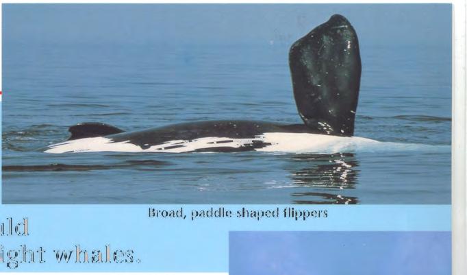
5 CAUTION MARINERS PLEASE AVOID COLLISIONS WITH RIGHT WHALES The North Atlantic right whale is the most endangered large whale only about 450 remain. Right whales are protected in Canadian waters under the Species at Risk Act. DISTINCTIVE FEATURES Adult length metres Weigh up to tonnes Slow swimmers, seldom moving faster than 3-5 knots Can stay submerged for 10 to 20 minutes and may appear quite suddenly when surfacing to breathe Often seen alone or in small groups SOCIAL BEHAVIOUR At times, right whales form large courtship groups of 20 to 30 + animals. TAIL Black, deeply notched tail flukes are raised vertically when diving. V-SHAPED BLOW The whale s profile on the surface is low; they are not easily seen except for their V-shaped blow when surfacing and flukes when diving. NO DORSAL FIN Smooth black back. CALLOSITIES Rough gray and whitish patches of raised skin on the top and sides of the head. Used by researchers to identify individuals. PLEASE AVOID CLOSE APPROACHES. RIGHT WHALES ARE DIFFICULT TO SEE AND MIGHT NOT BE AWARE OF VESSELS. FLIPPERS Short paddle-shaped. FOR MORE INFORMATION SEE CANADIAN COAST GUARD ANNUAL NOTICES TO MARINERS, AND Habitat Stewardship Program for Species At Risk

.")
6 North Atlantic right whales are Endangered Right whales in Atlantic Canada Right whales are found in the waters of Atlantic Canada from June through December. Their range extends from their critical habitat in the lower Bay of Fundy to the Roseway Basin Area To Be Avoided and the Scotian Shelf, with occasional sightings in the Gulf of St. Lawrence. Grand Manan Basin Right Whale Critical Habitat. Roseway Basin Right Whale Critical Habitat and IMO-ADOPTED Area To Be Avoided for ships of 300 gross tonnage and upwards during the period of 1 June through 31 December, (SN.1/Circ.263). A) B) C) D) 43 16'.0 N 42 47'.0 N 42 39'.0 N 42 52'.0 N 64 55'.0 W 64 59'.0 W 65 31'.0 W 66 05'.0 W A D B C Not to be used for navigation. See Canadian Hydrographic Service charts 4003 (2003 edition), 4011 and Right whales are injured or killed by collisions with vessels and entanglement in fishing gear. If you see a right whale, be aware that there may be more in your immediate area. Do not assume the whales will get out of your way. Please report sightings of injured, entangled, or dead right whales to Canadian Coast Guard 2182 khz or VHF 16, Fundy Traffic VHF 14 or the Whale Emergency Network Your help is greatly needed and appreciated. Canadian Whale Institute 2010
.")
7 Science, Service, Stewardship noaa fisheries service Reduce Collisions with North Atlantic Right Whales Use Two-Way Routes To Avoid Whales PURPOSE: To minimize vessel collisions with endangered right whales during the winter/spring feeding season in Cape Cod Bay (January through May). These two-way routes and two-way track were established based on historical patterns of right whale distribution during this time frame. WHO, WHERE, WHEN: The two-way routes and track shown in the chart to the right are STRONGLY RECOMMENDED for use by all vessels when transiting within or through Cape Cod Bay from January through May. The majority of Cape Cod Bay is designated Right Whale Critical Habitat. NORTHEAST REGION JANUARY - MAY HOW: The two-way routes and track may, at times, have opposing vessel traffic and all mariners should navigate with caution. Mariners are warned that some vessels may not be able to keep the starboard side of the routes at all times. CAUTION: Full bottom coverage surveys have not been conducted within the entire routes, so uncharted dangers may exist. This chart is for informational purposes only and is not to be used for navigation. For navigation, refer to the current version of NOAA Chart The area shaded in blue is designed critical habitat for North Atlantic right whales 50 CFR (b)). This area is a critical feeding area for whales between January and May each year. REMEMBER: Speed restrictions of 10 knots or less are mandatory in Seasonal Management Areas along the U.S. East Coast during times when right whales are likely present (See 50 CFR ). It is illegal to approach right whales closer than 500 yards (See 50 CFR (c), regulations, and exceptions). For more information visit: or U.S. Department of Commerce National Oceanic and Atmospheric Administration National Marine Fisheries Service

8 Science, Service, Stewardship Reduce Collisions with North Atlantic Right Whales noaa fisheries service Use Two-Way Routes To Avoid Whales SOUTHEAST REGION NOVEMBER - APRIL PURPOSE: To minimize vessel collisions with endangered right whales during the winter calving season from November through April. These two-way routes were established based on historical patterns of right whale distribution during this time frame. WHO, WHERE, WHEN: The two-way routes shown in the chart to the right are STRONGLY RECOMMENDED for use by all vessels when traveling into or out of the Florida ports of Jacksonville and Fernandina Beach, as well as Brunswick Harbor, Georgia, from November through April. HOW: The two-way routes may, at times, have opposing vessel traffic and all mariners should navigate with caution. Mariners are warned that some vessels might not be able to keep the starboard side of the routes at all times. CAUTION: Full bottom coverage surveys have not been conducted within the entire routes, so uncharted dangers may exist. TRANSITING BETWEEN ADJACENT PORTS: When transiting between adjacent ports within the critical habitat area, it is not necessary to use the two-way routes; however, mariners should minimize travel distance and use slowest safe speed when transiting outside the lanes. REMEMBER: Speed restrictions of 10 knots or less are mandatory in Seasonal Management Areas along the U.S. East Coast during times when right whales are likely present (See 50 CFR ). It is illegal to approach right whales closer than 500 yards (See 50 CFR (c), regulations, and exceptions). This chart is for informational purposes only and is not to be used for navigation. For navigation, refer to the current version of NOAA Chart The area shaded in blue is a calving area of North Atlantic right whales November 15 through April 15. This area encompasses the northern portion of the designated critical habitat for the whales (see 50 CFR (c)). The red dashed line extending East from Florida coastline, then North parallel to shore is the Mandatory Ship Reporting boundary line. For more information: visit or U.S. Department of Commerce National Oceanic and Atmospheric Administration National Marine Fisheries Service


9
10 THE MANDATORY SHIP REPORTING SYSTEM FACT SHEET The mandatory ship reporting system is aimed at increasing mariners awareness of the severity of the problem of ship strikes of the highly endangered Northern right whale and to seek their help in minimizing the threat. Starting July 1, 1999, all commercial ships of 300 gross tons and greater will be required to report to a shore-based station when they enter two areas off the east coast of the United States: one off Massachusetts and one off Georgia and Florida. The reporting system off Massachusetts will operate year round while the one off Georgia and Florida will operate each year from 15 November to 15 April, which corresponds with periods of right whale occurrence. Ships will be required to report their name, call sign, course, speed, location, destination, and route. In return, a vessel receives an automated message that provides where the latest information about right whale sightings and avoidance procedures that may prevent a collision may be found. For example, mariners will be advised to refer to navigational publications such as the U.S. Coast Pilot, Sailing Directions, and nautical charts for information on relevant regulations, and the boundaries of right whale critical habitats. The reporting system will affect no other aspect of vessel operation and there is no cost the mariner. For the large majority of ships, the information is transmitted in minutes by satellite to the ship s bridge computer. Information about the location of right whales is also being provided to mariners through various broadcast media, including the U.S. Coast Guard's Broadcasts to Mariners, satellite-linked marine safety broadcasts, and NOAA Weather Radio. Mariners will be advised that information placards, videos, and other educational materials are available from shipping agents, port authorities, relevant state agencies, the Coast Guard, and the National Marine Fisheries Service. Collectively, the reports will yield data on ship number and routes in right whale habitat, which will be useful in identifying possible further measures to reduce ship/whale interactions. The entire program will be reviewed in three to five years to assess its effectiveness, and to introduce advances in ship communication technologies that have become available. ###
ANNEX 23 RESOLUTION MSC.231(82) ADOPTION OF AMENDMENTS TO THE EXISTING MANDATORY SHIP REPORTING SYSTEM IN THE GULF OF FINLAND
 ADOPTION OF AMENDMENTS TO THE EXISTING MANDATORY SHIP REPORTING SYSTEM IN THE GULF OF FINLAND") RESOLUTION MSC.231(82) (adopted on 5 December 2006) ADOPTION OF AMENDMENTS TO THE EXISTING MANDATORY SHIP REPORTING SYSTEM IN THE GULF OF FINLAND THE MARITIME SAFETY COMMITTEE, RECALLING Article 28(b)
RESOLUTION MSC.231(82) (adopted on 5 December 2006) ADOPTION OF AMENDMENTS TO THE EXISTING MANDATORY SHIP REPORTING SYSTEM IN THE GULF OF FINLAND THE MARITIME SAFETY COMMITTEE, RECALLING Article 28(b)
Produced by Canadian Ice Service of. 2 December Seasonal Outlook Gulf of St Lawrence and East Newfoundland Waters Winter
 Environment Canada Environnement Canada Produced by Canadian Ice Service of Environment Canada 2 December 2010 Seasonal Outlook Gulf of St Lawrence and East Newfoundland Waters Winter 2010-2011 2010 Canadian
Kate Labrum
 2010-2011 Bren Group Project Proposal Boats, Whales, & the Santa Barbara Channel: An economic analysis & policy options for reducing the risk of vessel strikes to endangered whales Bren Student Proposers
NOAA Nautical Charts and Coastal and Marine Spatial Planning. Meredith Westington Chief Geographer NOAA/NOS/Office of Coast Survey
 NOAA Nautical Charts and Coastal and Marine Spatial Planning Meredith Westington Chief Geographer NOAA/NOS/Office of Coast Survey Ocean Policy Task Force What is CMSP? A comprehensive, adaptive, integrated,
VOYAGE (PASSAGE) PLANNING
 PLANNING") VOYAGE (PASSAGE) PLANNING Introduction O Passage planning or voyage planning is a procedure of developing a complete description of a vessel's voyage from start to finish. O Production of a passage plan
VOYAGE (PASSAGE) PLANNING Introduction O Passage planning or voyage planning is a procedure of developing a complete description of a vessel's voyage from start to finish. O Production of a passage plan
NAVIGATION AND VESSEL INSPECTION CIRCULAR NO
 COMDTPUB P16700.4 NVIC 13-92 15 Dec 1992 NAVIGATION AND VESSEL INSPECTION CIRCULAR NO. 13-92 Electronic Version for Distribution Via the World Wide Web Subj: Captain of the Port Zone Boundaries 1. PURPOSE.
On establishing the traffic separation schemes, separation of sea corridors and maritime special areas in the territorial sea of Georgia
 THE ORDER OF THE PRESIDENT OF GEORGIA 380 June 21, 2007 Tbilisi On establishing the traffic separation schemes, separation of sea corridors and maritime special areas in the territorial sea of Georgia
BookletChart. Intracoastal Waterway Bahia Honda Key to Sugarloaf Key NOAA Chart A reduced-scale NOAA nautical chart for small boaters
 BookletChart Intracoastal Waterway Bahia Honda Key to Sugarloaf Key NOAA Chart 11445 A reduced-scale NOAA nautical chart for small boaters When possible, use the full-size NOAA chart for navigation. Published
How and why is the timing and occurrence of seasonal migrants in the Gulf of Maine changing due to climate?
 How and why is the timing and occurrence of seasonal migrants in the Gulf of Maine changing due to climate? Dan Pendleton, ACCOL @ the New England Aquarium with PIs Michelle Staudinger & Adrian Jordaan
Prepared by the North American Ice Service. 4 December Seasonal Outlook Great Lakes Winter
 Prepared by the North American Ice Service A collaboration of the Canadian Ice Service and the National/Naval Ice Center 4 December 2008 Seasonal Outlook Great Lakes Winter 2008-2009 - 1 - Table of contents
IMO ROUTEING OF SHIPS, SHIP REPORTING AND RELATED MATTERS. Amendments to the existing mandatory ship reporting system In the Gulf of Finland
 INTERNATIONAL MARITIME ORGANIZATION E IMO SUB-COMMITTEE ON SAFETY OF NAVIGATION 52nd session Agenda item 3 NAV 52/3/5 12 April 2006 Original: ENGLISH ROUTEING OF SHIPS, SHIP REPORTING AND RELATED MATTERS
Real-time monitoring of right whales using autonomous underwater vehicles
 Real-time monitoring of right whales using autonomous underwater vehicles Dr. Kimberley Davies 1, Dr. Mark Baumgartner 2, Delphine Durette Morin 1, Hansen Johnson 1,2, Dr. Christopher Taggart 1 1. Department
National / Naval Ice Center (NIC) Operations Brief This brief is UNCLASSIFIED
 Operations Brief This brief is UNCLASSIFIED") National / Naval Ice Center (NIC) Operations Brief This brief is UNCLASSIFIED Christopher Szorc, Senior Ice Analyst/Forecaster USCG USN NOAA Outline NIC s mission is to provide timely, accurate and relevant
National / Naval Ice Center (NIC) Operations Brief This brief is UNCLASSIFIED Christopher Szorc, Senior Ice Analyst/Forecaster USCG USN NOAA Outline NIC s mission is to provide timely, accurate and relevant
Fish and Fish Habitat Follow-up Program. Scotian Basin Exploration Project
 Fish and Fish Habitat Follow-up Program Scotian Basin Exploration Project April 2018 Contents 1 Introduction... 1 2 Scope... 1 3 EIS Commitments and Predictions... 2 4 Methodology and Reporting... 2 4.1
Darren Wright Maritime Services Program Manager Center for Operational Oceanographic Products and Services (CO-OPS)
") Darren Wright Maritime Services Program Manager Center for Operational Oceanographic Products and Services (CO-OPS) Center for Operational Oceanographic Products and Services (CO-OPS) National Water Level
Darren Wright Maritime Services Program Manager Center for Operational Oceanographic Products and Services (CO-OPS) Center for Operational Oceanographic Products and Services (CO-OPS) National Water Level
Boundary Expansion of Thunder Bay National Marine Sanctuary; Correction and Expansion of Fagatele Bay National Marine
 This document is scheduled to be published in the Federal Register on 12/23/2015 and available online at http://federalregister.gov/a/2015-32265, and on FDsys.gov Billing Code 3510-NK-P DEPARTMENT OF COMMERCE
[50/16] WMO SURVEY. Admiralty Charts affected by the Publication List
![[50/16] WMO SURVEY. Admiralty Charts affected by the Publication List](/thumbs/91/106481495.jpg "[50/16] WMO SURVEY. Admiralty Charts affected by the Publication List") Admiralty Charts affected by the Publication List [50/16] Admiralty Chart Admiralty Chart 410 AUS 58 536 AUS 60 1444 AUS 510 1534 AUS 621 1535 INT 1160 2014 INT 1201 2015 INT 1202 2018 INT 1218 2040 INT
Admiralty Charts affected by the Publication List [50/16] Admiralty Chart Admiralty Chart 410 AUS 58 536 AUS 60 1444 AUS 510 1534 AUS 621 1535 INT 1160 2014 INT 1201 2015 INT 1202 2018 INT 1218 2040 INT
Advancing Real Time Observations and Coastal Modeling Forecasts-
 Advancing Real Time Observations and Coastal Modeling Forecasts- Moving Forward in a Changing Coastal Landscape Next Generation Navigation-Coastal Operations- Coastal and Nearshore Coastal Operational
Routeing. Voyage preparation, -planning and -implementation
 Routeing Voyage preparation, -planning and -implementation Routeing possibilities Weather routeing By own information By external party Climatologic Routeing By charts and books Weather Routeing Basis
DFO Maritimes Region Update. Gulf of Maine Council - Coastal and Marine Spatial Planning (CMSP) Committee Web-Ex May 16, 2017
 Committee Web-Ex May 16, 2017") DFO Maritimes Region Update Gulf of Maine Council - Coastal and Marine Spatial Planning (CMSP) Committee Web-Ex May 16, 2017 1 National Oceans Priorities Marine Conservation Targets Oceans Protection Plan
DFO Maritimes Region Update Gulf of Maine Council - Coastal and Marine Spatial Planning (CMSP) Committee Web-Ex May 16, 2017 1 National Oceans Priorities Marine Conservation Targets Oceans Protection Plan
NATIONAL REPORT OF HYDROGRAPHIC SERVICE OF THE RUSSIAN FEDERATION NAVY
 2nd Meeting Arctic Regional Hydrographic Commission Copenhagen Denmark September 28-29, 2011 ARHC2-02B National report Russian Federation NATIONAL REPORT OF HYDROGRAPHIC SERVICE OF THE RUSSIAN FEDERATION
1 Executive summary. 2 Principles of SAT-OCEAN service
 S SCOPE OF WORK FOR ROUTING SERVICES 1 Executive summary SAT-OCEAN has developed an innovative routing service enabling for significant time and energy savings. This solution is going beyond traditional
NEWS RELEASE. Province boosts winter highway safety measures
 For Immediate Release 2018TRAN0045-000567 April 4, 2018 NEWS RELEASE Province boosts winter highway safety measures VICTORIA Following an intense winter, the is undertaking several improvements to make
Movements of striped bass in response to extreme weather events
 Movements of striped bass in response to extreme weather events Helen Bailey and David Secor E-mail: hbailey@umces.edu 1 Background 2 Outline What is movement ecology? Methods for analyzing animal tracks
Draft exercise for share fair at Bozeman workshop only. This exercise is not ready for distribution. Please send helpful suggestions to
 Draft exercise for share fair at Bozeman workshop only. This exercise is not ready for distribution. Please send helpful suggestions to foleyd@plu.edu Figure list 1. Trailer photograph 2. Location map
BOWDITCH PLUS! The Complete Navigator s Library Table of Contents
 STARPATH BOWDITCH PLUS! The Complete Navigator s Library Table of Contents The American Practical Navigator (Bowditch 2002) The US encyclopedia of navigation, some 1000 pages covers all aspects of navigation,
Vessel Strikes to Large Whales Before and After the 2008 Ship Strike Rule
 LETTER Vessel Strikes to Large Whales Before and After the 2008 Ship Strike Rule Julie M. van der Hoop 1, Angelia S. M. Vanderlaan 2, Timothy V. N. Cole 3, Allison G. Henry 3, Lanni Hall 4, Blair Mase-Guthrie
Marine Weather Hazards, Manual: West Coast Edition By Environment Canada READ ONLINE
 Marine Weather Hazards, Manual: West Coast Edition By Environment Canada READ ONLINE The trail runs along the west to Environment canada s Marine Weather Hazards Manual. mouth of large inlets in the winter.
GC Briefing. Weather Sentinel Hurricane Florence. Status at 5 PM EDT (21 UTC) Today (NHC) Discussion. September 13, 2018
 Today (NHC) Discussion. September 13, 2018") GC Briefing September 13, 2018 Weather Sentinel Hurricane Florence Tropical storm conditions have been reported for areas of North Carolina and will continue to spread inland to the west and south. Hurricane
GC Briefing September 13, 2018 Weather Sentinel Hurricane Florence Tropical storm conditions have been reported for areas of North Carolina and will continue to spread inland to the west and south. Hurricane
NOAA s National Weather Service Philadelphia/Mt. Holly NJ. Summary. Changes
 Summary A crippling and potentially historic east coast snow storm will lead to blizzard conditions and major coastal flooding for portions of the area this weekend. Changes Blizzard Warning has been expanded
Your web browser (Safari 7) is out of date. For more security, comfort and the best experience on this site: Update your browser Ignore
 is out of date. For more security, comfort and the best experience on this site: Update your browser Ignore") Your web browser (Safari 7) is out of date. For more security, comfort and the best experience on this site: Update your browser Ignore Activitydevelop NO RTH ATL ANTIC RIGHT W HALES How can you use maps
Your web browser (Safari 7) is out of date. For more security, comfort and the best experience on this site: Update your browser Ignore Activitydevelop NO RTH ATL ANTIC RIGHT W HALES How can you use maps
Presentation of the system
 Limiting the risks of collision between commercial vessels and large cetaceans Presentation of the system Last updated : 7 th March 2012 REPCET V.1 Souffleurs d Ecume Scientific association for the protection
Analysis of Satellite AIS Data to Derive Weather Judging Criteria for Voyage Route Selection
 http://www.transnav.eu the International Journal on Marine Navigation and Safety of Sea Transportation Volume 11 Number 2 June 2017 DOI: 10.12716/1001.11.02.09 Analysis of Satellite AIS Data to Derive
Severe Weather Hazards Are Real
 Severe Weather Hazards Are Real In the past 10 years, more than 40 people have died and dozens more injured as a result of weatherrelated events in Minnesota (not including motor vehicles.) The top severe
Notice to Mariners. Rampion Offshore Wind Farm Date of Issue: 12/01/2018 Notice Expires: Ongoing
 Dear Authorities, Owners, Ships Agents, Masters, Pilots and Fishermen, Re: - Installation of New East Export cable update. This NTM supersedes and closes out NTM 87 The Stemat Spirit has completed removal
Ocean Currents Student Activity Book
 Ocean Currents Student Activity Book I. Introduction Ocean currents influence the weather in coastal areas. They also influence sailing vessels. Though they visibly affect many people's lives, they are
Near-Field Sturgeon Monitoring for the New NY Bridge at Tappan Zee. Quarterly Report October 1 December 31, 2014
 Near-Field Sturgeon Monitoring for the New NY Bridge at Tappan Zee Quarterly Report October 1 December 31, 2014 Prepared by AKRF, Inc. 7250 Parkway Drive, Suite 210 Hanover, MD 21076 for New York State
Background Information
 Oceanography LAB #1: Marine Charts and Navigation Background Information Latitude and Longitude A coordinate is an address a means of designating location. Most coordinate systems involve a network of
REVIEW OF ALTERNATE BALLAST WATER EXCHANGE ZONES FOR VESSEL TRAFFIC TO NEWFOUNDLAND AND LABRADOR AND THE CANADIAN ARCTIC
 Canadian Science Advisory Secretariat Science Advisory Report 2010/026 REVIEW OF ALTERNATE BALLAST WATER EXCHANGE ZONES FOR VESSEL TRAFFIC TO NEWFOUNDLAND AND LABRADOR AND THE CANADIAN ARCTIC Figure 1:
PUBLIC SAFETY POWER SHUTOFF POLICIES AND PROCEDURES
 PACIFIC GAS AND ELECTRIC COMPANY PUBLIC SAFETY POWER SHUTOFF POLICIES AND PROCEDURES SEPTEMBER 2018 1 PACIFIC GAS AND ELECTRIC COMPANY PUBLIC SAFETY POWER SHUTOFF POLICIES AND PROCEDURES SEPTEMBER 2018
Introduction to Google Earth
 Introduction to Google Earth Name Goals 1. To become proficient at using the basic features of Google Earth. 2. To recognize differences in coastal features between the east and west coast of North America.
Northeast U.S. Early Season Preview 2017 FISHING ACTION STARTING TO WARM UP ALREADY WITH LOTS OF FISH EXPECTED IN MAY
 Northeast U.S. Early Season Preview 2017 FISHING ACTION STARTING TO WARM UP ALREADY WITH LOTS OF FISH EXPECTED IN MAY By Matthew A. Upton and Mitchell A. Roffer ROFFS concludes its 2017 spring preview
WEDNESDAY 30 TH AUGUST, :57 p.m. Tropical Storm Irma forms in the Atlantic. Don t let your guard down, always #Be Ready.
 Chapter 1 - The Set Up In the days leading up to Irma a series of composed and sobering text messages, presented in truncated form below, from Department of Disaster Management warned us of the pending
El Niño Update Impacts on Florida
 Current Issues in Emergency Management (CIEM) Sessions 1 &2 October 12 th and 26 th, 2006 Florida Division of Emergency Management Tallahassee, Florida El Niño Update Impacts on Florida Bart Hagemeyer
Tornado Hazard Risk Analysis: A Report for Rutherford County Emergency Management Agency
 Tornado Hazard Risk Analysis: A Report for Rutherford County Emergency Management Agency by Middle Tennessee State University Faculty Lisa Bloomer, Curtis Church, James Henry, Ahmad Khansari, Tom Nolan,
Maritime Weather Information: Automatic Reporting, A New Paradigm
 Maritime Weather Information: Automatic Reporting, A New Paradigm Joe Sienkiewicz, NOAA/NWS Ocean Prediction Center Responsibilities under SOLAS Met Services Contracting governments Observations Limited
Information Reception: Decision Support Standards: Public Notification Plan: Protection Program: Education:
 The National Weather Service (NWS) has implemented a voluntary recognition program to help large outdoor venues, including those on university campuses, better protect staff and patrons from the dangers
tornadoes in oklahoma Christi HAgen
 tornadoes in oklahoma Christi HAgen 17 Introduction Tornadoes are some of the world s most severe phenomena. They can be miles long, with wind speeds over two hundred miles per hour, and can develop in
Hurricane Matthew Threats and Impacts Briefing for Eastern NC
 Hurricane Matthew Threats and Impacts Briefing for Eastern NC October 6 th, 2016 Date/Time Created: 10/6/2016, Noon EDT National Weather Service Newport/Morehead City, NC Hurricane Matthew Key Points Changes
Responsive Traffic Management Through Short-Term Weather and Collision Prediction
 Responsive Traffic Management Through Short-Term Weather and Collision Prediction Presenter: Stevanus A. Tjandra, Ph.D. City of Edmonton Office of Traffic Safety (OTS) Co-authors: Yongsheng Chen, Ph.D.,
Relatively little hard substrate occurs naturally in the
 CHAPTER FIVE Rock Habitats Relatively little hard substrate occurs naturally in the estuary, owing mainly to the vast quantities of fine sediment that have been deposited by the rivers. Rock habitat is
Using GIS and Remote Sensing to Manage North Atlantic Right Whale Populations Eleni Gesch-Karamanlidis
 Using GIS and Remote Sensing to Manage North Atlantic Right Whale Populations Eleni Gesch-Karamanlidis Northern Right whales remain one of the most endangered mammals in the ocean (Ward-Geiger et al 2005,
Hurricane Season 2010 & NOAA s Deepwater Response
 Hurricane Season 2010 & NOAA s Deepwater Response What s Happened? What Will 2010 Bring? Possible Shoreline Effects Darin Figurskey Meteorologist-in-Charge NOAA s NWS Raleigh, NC NOAA s National Weather
APPENDIX B PHYSICAL BASELINE STUDY: NORTHEAST BAFFIN BAY 1
 APPENDIX B PHYSICAL BASELINE STUDY: NORTHEAST BAFFIN BAY 1 1 By David B. Fissel, Mar Martínez de Saavedra Álvarez, and Randy C. Kerr, ASL Environmental Sciences Inc. (Feb. 2012) West Greenland Seismic
KCC White Paper: The 100 Year Hurricane. Could it happen this year? Are insurers prepared? KAREN CLARK & COMPANY. June 2014
 KAREN CLARK & COMPANY KCC White Paper: The 100 Year Hurricane Could it happen this year? Are insurers prepared? June 2014 Copyright 2014 Karen Clark & Company The 100 Year Hurricane Page 1 2 COPLEY PLACE
PARTICIPATION IN THE WMO VOLUNTARY OBSERVING SHIPS (VOS) SCHEME
 SCHEME") INTERNATIONAL MARITIME ORGANIZATION 4 ALBERT EMBANKMENT LONDON SE1 7SR Telephone: 020 7735 7611 Fax: 020 7587 3210 IMO E Ref. T2-OSS/1.4 MSC.1/Circ.1293 10 December 2008 PARTICIPATION IN THE WMO VOLUNTARY
INTERNATIONAL MARITIME ORGANIZATION 4 ALBERT EMBANKMENT LONDON SE1 7SR Telephone: 020 7735 7611 Fax: 020 7587 3210 IMO E Ref. T2-OSS/1.4 MSC.1/Circ.1293 10 December 2008 PARTICIPATION IN THE WMO VOLUNTARY
The Integrated Warning Partnership: Opportunities for Improved Community-Level Benefits. Dale Morris Oklahoma Climatological Survey April 18, 2006
 The Integrated Warning Partnership: Opportunities for Improved Community-Level Benefits Dale Morris Oklahoma Climatological Survey April 18, 2006 My Personal Motivation Sunday Evening, September 5, 1992
IN VEHICLES: Do not try to outrun a tornado. Abandon your vehicle and hide in a nearby ditch or depression and cover your head.
 TORNADO SAFETY TORNADO! The very word strikes fear in many people. While a tornado is perhaps nature's most destructive storm, deaths and injuries can be prevented. By following Tornado Safety Rules, lives
Eastern Shore Weather and Climate. Bill Sammler Warning Coordination Meteorologist National Weather Service Wakefield, VA
 Eastern Shore Weather and Climate Bill Sammler Warning Coordination Meteorologist National Weather Service Wakefield, VA About The NWS The National Weather Service is: A Federal Government Agency Part
HURRICANES AND TORNADOES
 HURRICANES AND TORNADOES The most severe weather systems are hurricanes and tornadoes. They occur in extremely low pressure systems, or cyclones, when the air spirals rapidly into the center of a low.
OCTOBER 24-26,1982, ATLANTIC COAST STORM: A CHRONOLOGY AND INSIGHT
 Severe Weather Volume 9 Number 1 OCTOBER 24-26,1982, ATLANTIC COAST STORM: A CHRONOLOGY AND INSIGHT David B. Caldwell (1) National Weather Service Forecast Office 5200 Aulh Road Washlnglon, D.C. 20233
Canadian Ice Service
 Canadian Ice Service Key Points and Details concerning the 2009 Arctic Minimum Summer Sea Ice Extent October 1 st, 2009 http://ice-glaces.ec.gc.ca 1 Key Points of Interest Arctic-wide The Arctic-wide minimum
National Maritime Center
 National Maritime Center Providing Credentials to Mariners (Sample Examination) Page 1 of 14 Choose the best answer to the following Multiple Choice Questions. 1. Sometimes foreign charts are reproduced
UNIVERSITY OF WISCONSIN-PARKSIDE TORNADO WARNINGS AND ALERT POLICY ADMINISTRATIVE POLICY NUMBER 39 TABLE OF CONTENTS
 UNIVERSITY OF WISCONSIN-PARKSIDE TORNADO WARNINGS AND ALERT POLICY ADMINISTRATIVE POLICY NUMBER 39 TABLE OF CONTENTS Page 1. PURPOSE 2 2. DEFINITIONS 2 3. GENERAL OVERVIEW 2 4. SPECIFIC PROCEDURES 3 4.1
EFFECTIVE TROPICAL CYCLONE WARNING IN BANGLADESH
 Country Report of Bangladesh On EFFECTIVE TROPICAL CYCLONE WARNING IN BANGLADESH Presented At JMA/WMO WORKSHOP ON EFFECTIVE TROPICAL CYCLONE WARNING IN SOUTHEAST ASIA Tokyo, Japan,11-14 March 2014 By Sayeed
Please give me the background details of the warning system the US had before and the new improvements now.
 ----- Original Message ----- From: VADM Conrad C. Lautenbacher Jr., USN (Ret.) To: Announcement@noaa.gov Sent: Friday, January 28, 2005 1:30 PM Subject: Message from the Under Secretary -- NOAA Tsunami
Serial No. N4470 NAFO SCR Doc. 01/83 SCIENTIFIC COUNCIL MEETING SEPTEMBER 2001
 NOT TO BE CITED WITHOUT PRIOR REFERENCE TO THE AUTHOR(S) Northwest Atlantic Fisheries Organization Serial No. N7 NAFO SCR Doc. /8 SCIENTIFIC COUNCIL MEETING SEPTEMBER Sea-surface Temperature and Water
Tropical Update. 5 PM EDT Sunday, September 10, 2017 Hurricane Irma, Hurricane Jose, Tropical Wave (60%)
") Tropical Update 5 PM EDT Sunday, September 10, 2017 Hurricane Irma, Hurricane Jose, Tropical Wave (60%) This update is intended for government and emergency response officials, and is provided for informational
Tropical Update 5 PM EDT Sunday, September 10, 2017 Hurricane Irma, Hurricane Jose, Tropical Wave (60%) This update is intended for government and emergency response officials, and is provided for informational
Tahlequah Public Schools Inclement Weather Transportation Plan
 Tahlequah Public Schools Inclement Weather Transportation Plan Inclement Weather with Ice and Snow From time to time throughout the school year, weather may force a change in the District s normal operating
Common Core Reading Passage
 Directions: Please read the following Common Core Reading passage and answer the questions that follow. Common Core Reading Passage Forecasting Severe Weather to Communities Helps Them Prepare By Alissa
What is a tsunami? Capital Regional District Tsunami Frequently Asked Questions (FAQ s) Tsunami (soo-nah-mee)
 Tsunami (soo-nah-mee)") Tsunami (soo-nah-mee) Tsunamis (Japanese translation harbour wave ) are waves with a great distance between crests, and are caused by any widespread, sudden movement of large volumes of water. The tsunami
Tsunami (soo-nah-mee) Tsunamis (Japanese translation harbour wave ) are waves with a great distance between crests, and are caused by any widespread, sudden movement of large volumes of water. The tsunami
Guide for planning international transit voyages on the NSR
 The Arctic 2030 Project: Feasibility and Reliability of Shipping on the Northern Sea Route and Modeling of an Arctic Marine Transportation & Logistics System 1-st Industry Seminar: NSR s Legislation, Tariff
FOURTH INTERNATIONAL PORT METEOROLOGICAL OFFICERS WORKSHOP AND SUPPORT TO GLOBAL OCEAN OBSERVATIONS USING SHIP LOGISTICS
 FOURTH INTERNATIONAL PORT METEOROLOGICAL OFFICERS WORKSHOP AND SUPPORT TO GLOBAL OCEAN OBSERVATIONS USING SHIP LOGISTICS PMO-IV 8-10 DEC 2010, ORLANDO, FLORIDA, USA 1 This presentation is generally for
WIND DATA REPORT FOR THE YAKUTAT JULY 2004 APRIL 2005
 WIND DATA REPORT FOR THE YAKUTAT JULY 2004 APRIL 2005 Prepared on July 12, 2005 For Bob Lynette 212 Jamestown Beach Lane Sequim WA 98382 By John Wade Wind Consultant LLC 2575 NE 32 nd Ave Portland OR 97212
No JANUARY 2014 UNITED STATES OF AMERICA. Contents
 2 11 JANUARY 2014 UNITED STATES OF AMERICA Published Weekly by the National Geospatial-Intelligence Agency Prepared Jointly with the National Ocean Service and U.S. Coast Guard Contents Section I Chart
The Information System in ECDIS
 The Information System in ECDIS Bjørn Åge Hjøllo Product Manager Weather/Routing/Piracy Jeppesen, Norway Nordic Institute of Navigation (NNF); Seminar on enavigation Bergen, May 2011 19 May 2011-1 - enavigation
CHAPTER 24 THE SAILINGS
 CHAPTER 24 THE SAILINGS INTRODUCTION 2400. Introduction Dead reckoning involves the determination of one s present or future position by projecting the ship s course and distance run from a known position.
A Boundary Delineation System for the Bureau of Ocean Energy Management
 A Boundary Delineation System for the Bureau of Ocean Energy Management Doug Vandegraft Chief, Mapping and Boundary Branch BOEM Coastal Geotools - 2015 Outline Introduction BOEM Marine Cadastre Background
CHAPTER 20 SIGHT REDUCTION
 CHAPTER 20 SIGHT REDUCTION BASIC PRINCIPLES 2000. Introduction Reducing a celestial sight to obtain a line of position consists of six steps: 1. Correcting sextant altitude (hs) to obtain observed altitude
Page 1. A Grieg Group Company
 Page 1 ECDIS PAST, PRESENT & Future 2000-2010 Past Present 2010-2015 2015... Future Page 2 History Page 3 DEEPLY - Past What is going on there????? I am Checking now Sir Page 4 ECDIS History ECDIS has
Marine Notice No. 13 of 2009
 Marine Notice No. 13 of 2009 NOTICE TO ALL SHIPOWNERS, FISHING VESSEL OWNERS, AGENTS, SHIPMASTERS, SHIP MANAGEMENT COMPANIES, SKIPPERS, FISHERMEN, YACHTSMEN AND SEAFARERS. HELP IMPROVE QUALITY OF WEATHER
Snow Removal Policy WARREN COUNTY ENGINEER S OFFICE (WCEO) WARREN COUNTY HIGHWAY DEPARTMENT. October 16, 2014
 WARREN COUNTY HIGHWAY DEPARTMENT. October 16, 2014") Snow Removal Policy WARREN COUNTY ENGINEER S OFFICE (WCEO) October 16, 2014 Presented by: Neil F. Tunison, Warren County Engineer Snow Removal Policy OPERATIONS SAFETY WARREN COUNTY ENGINEER S OFFICE (WCEO)
Snow Removal Policy WARREN COUNTY ENGINEER S OFFICE (WCEO) October 16, 2014 Presented by: Neil F. Tunison, Warren County Engineer Snow Removal Policy OPERATIONS SAFETY WARREN COUNTY ENGINEER S OFFICE (WCEO)
University of New Hampshire Scholars' Repository
 University of New Hampshire University of New Hampshire Scholars' Repository Center for Coastal and Ocean Mapping Center for Coastal and Ocean Mapping 3-2009 Environmental Response Management Application
The Climate of Payne County
 The Climate of Payne County Payne County is part of the Central Great Plains in the west, encompassing some of the best agricultural land in Oklahoma. Payne County is also part of the Crosstimbers in the
2004 State of the Ocean: Physical Oceanographic Conditions in the Newfoundland and Labrador Region
 Canadian Science Advisory Secretariat Science Advisory Report 25/18 Research vessel CCGS Teleost 24 State of the Ocean: Physical Oceanographic Conditions in the Newfoundland and Labrador Region Background
El Niño & Expected Florida Severe Weather
 El Niño & Expected Florida Severe Weather Brady Smith, AICP, CFM Tampa Bay Regional Planning Council brady@tbrpc.org ONE BAY Resilient Communities Working Group Meeting February 5, 2016 El Niño & Expected
REPUBLIC OF THE MARSHALL ISLANDS MARITIME ZONES DECLARATION ACT 2016.
 Republic of the Marshall Islands Maritime Zones Declaration Act 2016. 33MIRCCh.1Index TITLE 33 - MARINE ZONES AND PROTECTION OF MAMMALS CHAPTER 1 - MARITIME ZONE DECLARATION s Republic of the Marshall
WEATHER NOTIFICATION STATEMENT
 WEATHER NOTIFICATION STATEMENT NEW DATA SHOWS SNOWSTORM THREAT FOR JAN 13-14 LOOKS MUCH HEAVIER BIGGER COVERAGE northwest NC (ice) ALL OF VA (Except Hampton Roads) all of MD/ DEL eastern southern PA southern
HURRICANE Information for the Teacher
 HURRICANE Information for the Teacher This hurricane simulation activity and STELLA model were adapted from materials developed by Jan Mons and Cathy Eaton of the Glynns Integration of Systems Thinking
2011 Year in Review TORNADOES
 2011 Year in Review The year 2011 had weather events that will be remembered for a long time. Two significant tornado outbreaks in April, widespread damage and power outages from Hurricane Irene in August
Visual Notices to mariners & Navigational Warnings
 Visual Notices to mariners & Navigational Warnings 22 MAY, 2017 Hydrographic and Oceanographic Department Talking about: Visual Notices to Mariners & Navigational Warning System Text on a paper Text information
ENSO Cycle: Recent Evolution, Current Status and Predictions. Update prepared by Climate Prediction Center / NCEP 23 April 2012
 ENSO Cycle: Recent Evolution, Current Status and Predictions Update prepared by Climate Prediction Center / NCEP 23 April 2012 Outline Overview Recent Evolution and Current Conditions Oceanic Niño Index
Developed in Consultation with Florida Educators
 Developed in Consultation with Florida Educators Table of Contents Next Generation Sunshine State Standards Correlation Chart... 7 Benchmarks Chapter 1 The Practice of Science...................... 11
4th Grade Social Studies First Nine Weeks
 4th Grade Social Studies First Nine Weeks Multiple Choice Identify the choice that best completes the statement or answers the question. 1 Name the mountains that are located in the eastern United States.
METEOROLOGICAL WARNINGS STUDY GROUP (METWSG)
") METWSG/4-SN No. 6 12/3/12 METEOROLOGICAL WARNINGS STUDY GROUP (METWSG) FOURTH MEETING Montréal, 15 to 18 May 2012 Agenda Item 6: Wind shear, turbulence and tsunami warnings TSUNAMI INFORMATION (Presented
METWSG/4-SN No. 6 12/3/12 METEOROLOGICAL WARNINGS STUDY GROUP (METWSG) FOURTH MEETING Montréal, 15 to 18 May 2012 Agenda Item 6: Wind shear, turbulence and tsunami warnings TSUNAMI INFORMATION (Presented
WESTERN GRAY WHALE ADVISORY PANEL WGWAP 5/18 5 th Meeting December 2008 ENGLISH. Comparison of shore-based scan counts WGWAP 5/18
 WESTERN GRAY WHALE ADVISORY PANEL WGWAP 5/18 5 th Meeting December 2008 ENGLISH Comparison of shore-based scan counts WGWAP 5/18 Comparison of Shore-Based Scan Counts Background As part of the recommendations
PORTUGAL NATIONAL REPORT
 PORTUGAL NATIONAL REPORT 14 TH MEETING OF THE EASTERN ATLANTIC HYDROGRAPHIC COMMISSION Cadiz, Spain 18 th 20 th October 2016 INSTITUTO HIDROGRÁFICO Miguel Arenga IHPT Head of the Hydrography Division 2016-10-18
The Climate of Grady County
 The Climate of Grady County Grady County is part of the Central Great Plains, encompassing some of the best agricultural land in Oklahoma. Average annual precipitation ranges from about 33 inches in northern
1.6 Getting Started on Resources. Time for Trivial Pursuit!
 06, 12, and 18Z. Note this is easy to do if you are looking for data within the past 24 hours. It is doable but harder to sift through the archives to find older data. From a practical point of view this