Routeing. Voyage preparation, -planning and -implementation
|
|
|
- Zoe Austin
- 5 years ago
- Views:
Transcription

1 Routeing Voyage preparation, -planning and -implementation
2 Routeing possibilities Weather routeing By own information By external party Climatologic Routeing By charts and books
3 Weather Routeing Basis weather routeing Ships particulars 10 day forecast from which wind- and wave prognosis can be made By means of wave prognosis and ships particulars you determine timezones and the optimum route can be determined

4 Wind Today's wind chart created with windy.com

5 Waves Today s wave chart created with windy.com

6 Do not forget your Barometer!
7 Meteoconsult - SPOS SPOS bundles meteo information of: ECMWF (Europe) UKMO or Bracknell model (UK) NCEP (USA) To construct the so called NMB model
8 SPOS prognoses are the best available results NMB compared to individual models ECMWF UKMO NCEP Day 1 5% 9% 20% Day 2 8% 11% 21% Day 3 13% 14% 21% Day 4 16% 17% 27% Day 5 20% 11% 24% Day % -- 29% explanation: prediction for day 4: ECMWF prediction error is 16% larger than NMB prediction error, NCEP error is 27% larger
9 Climatologic routeing By experience and knowledge about the meteorologic- and oceanographic information obtained throughout many years a crossing is planned
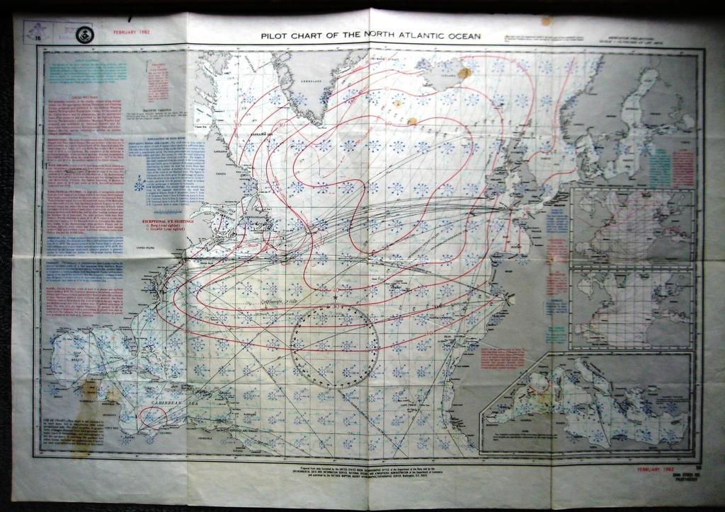
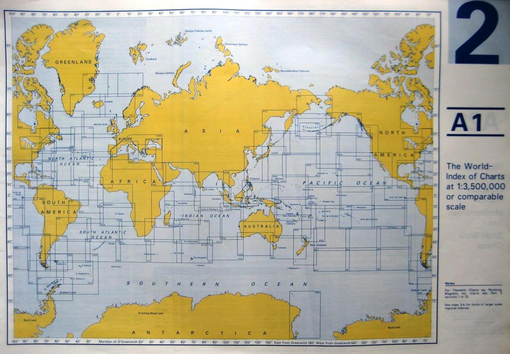
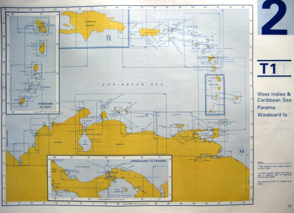
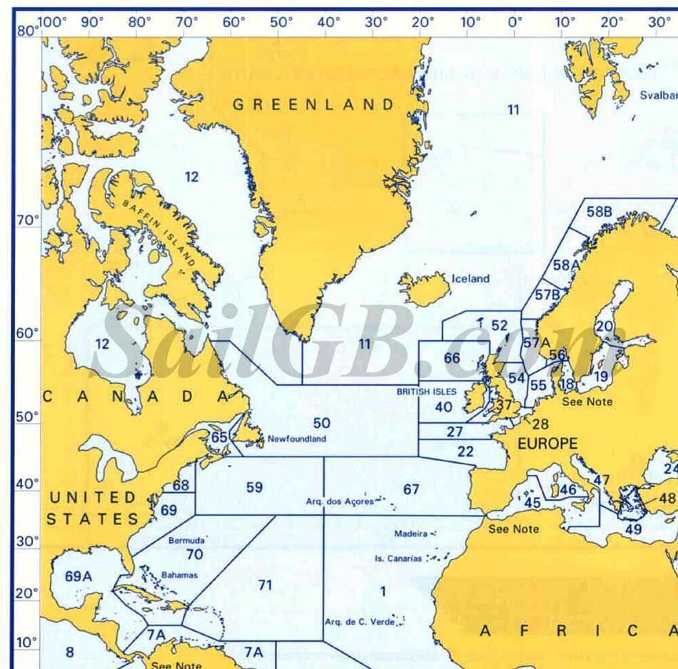
10 PILOTCHARTS
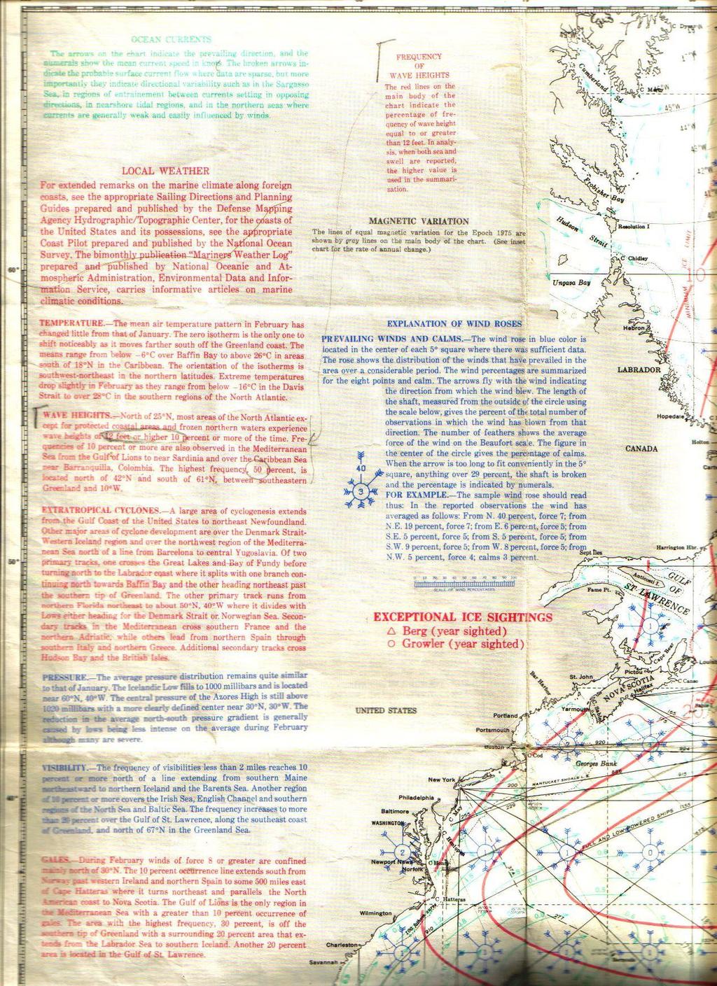
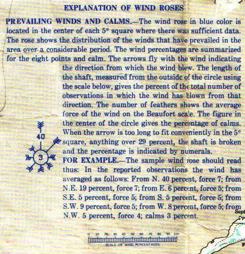
11 De PILOTCHART

12 Voyage preparation: Plan Weather Charts (corrected) Pilots Nautical Publications OPFTW / IMO ships routeing Plan B
13 Voyage plan Sailsperfect. datum... Harbor of Departure: Sailing area: (Lille Belt,English Channel) Arrival: Charts needed: Corrected until: Pilots: Tidal information: Communication info: Route expectation: Fuel and water: Emergency plan/port: Chart and pilots:

14 Charts and Books

15 Chart Catalogue
16 Catalogue
17 Catalogue
18 Catalogue
19 Catalogue
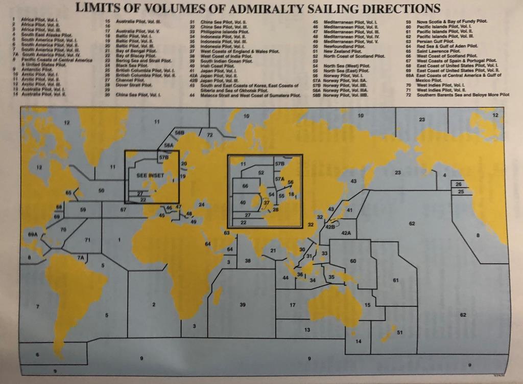
20 Books: ALRS (admiralty list of radio signals) Volume 1 (Part 1 and 2) Volume 2 Volume 3 (part 1 an 2) Volume 4 Volume 5 Volume 6 (part 1-6) Maritime Radio stations Radio Aids to navigation, Differential GPS, Legal Time, Electronic Time signals and Electronic position fixing system Maritime Weather Services Maritime Safety Information broadcasts worldwide NAVTEX and SafetyNET information Submarine and Gunnery Warning details (Subfacts and Gunfacts) Radio- Facsimile Stations, frequencies and weather map Meteorological observation stations GMDSS Pilot services, VTS and Port Operations
 -Ships Routeing (IMO) (for merchant shipping) -World Cruising Routes, Jimmy Cornell (Sailing")
21 PILOTS: Admiralty Sailing Directions Nautical Pillot 1 to 99 Nautical Pilot 100 Nautical Pilot 136 Routeing: World coverage (also available digital) Mariners handbook Opftw -Ocean Passages For the World (NP 136) -Ships Routeing (IMO) (for merchant shipping) -World Cruising Routes, Jimmy Cornell (Sailing Yachts)
22
23

24 Admiralty List of Lights (ALL) Volume A to L World coverage (also available digital)

25 Admiralty Tide Tables (ATT) Volume 1 to 8 World coverage (also available digital)

26 Ocean passages for the World How does the OPftW look like? Contents Gazetter Index
27 Ocean passages for the World Contant: Part I Ch1 Planning a Passage Ch 2-7 Ocean routes Power Driven Vessels Part II Ch 8-10 Ocean routes Sailing Ships and slow vessels Gazetter, Index

28 Planning a passage by OPftW

29 Planning a passage by OPftW

30 How do you find your route?
31 In what chapters-paragraphs do I find my route?
32 !
33

34 Sailing Routes described in chapter 8-10
35 Opftw available for use in the EZS library (previous century editions) New editions still available from admiralty
36 Charts Study Title meters-fathoms-reduction level-heights? notices and dangers? Course With (soft) pencil clearly and with number Practice course transfer to next chart Dangers Mark obviously Mark where you definitely don t want to be! (hatch) If needed note passing distances Obvious points like Capes, beacons, lights Mark clearly If needed note passing distances
37
38
39

40 Use Pilots
41 Boundaries Pilot

42 ALWAYS consult the latest SUPPLEMENT

43 By Index it is easy to find what is important to you.
44

45 USE list of lights

46 via Index to light

47 Ships Routeing (IMO publication)


48 2015 version Available to use in EZS library Please do not take home

49 World Cruising routes Jimmy Cornell
50 Manoeuvring near Pilot station Use manoeuvring board or booklet Use the given wind and wave information for determining your course upon pilot embarking. Pay attention to surrounding! (room)

51 3,1 mijl At 15 knots to 0 knots takes 72 min. Distance needed: 4,0 miles. From 14 to 3 knots takes 27 minuten. Distance is 3,1 miles.

52 Open water: Squat in meters= Cb x V (knots) ² 100 Cb=0,7 ; v= 9 knots Squat = 0,57 meter Channel conditions Squat open water X 2 Cb=0,8 ; v= 10 knots Squat = 1,6 meter Rather extreme graph!
53 Tidal calculation Make a rough tidal calculation for your arrival harbour Eef s lesson
54 Tidal calculationve Example required UKC 0,5 Draft 7,5 SQUAT 0,5 + Needed water 8,5 Chart depth 5,8 - Minimum waterlevel above chart datum 2,7 m Use this in tidal curve!
55 LW
56 Summary: Weather: Voyage planning: -plan -charts -pilots -Nautical publications -Opftw -plan B -Weather routing -Climatologic routing
VOYAGE (PASSAGE) PLANNING
 PLANNING") VOYAGE (PASSAGE) PLANNING Introduction O Passage planning or voyage planning is a procedure of developing a complete description of a vessel's voyage from start to finish. O Production of a passage plan
VOYAGE (PASSAGE) PLANNING Introduction O Passage planning or voyage planning is a procedure of developing a complete description of a vessel's voyage from start to finish. O Production of a passage plan
ANNEX 23 RESOLUTION MSC.231(82) ADOPTION OF AMENDMENTS TO THE EXISTING MANDATORY SHIP REPORTING SYSTEM IN THE GULF OF FINLAND
 ADOPTION OF AMENDMENTS TO THE EXISTING MANDATORY SHIP REPORTING SYSTEM IN THE GULF OF FINLAND") RESOLUTION MSC.231(82) (adopted on 5 December 2006) ADOPTION OF AMENDMENTS TO THE EXISTING MANDATORY SHIP REPORTING SYSTEM IN THE GULF OF FINLAND THE MARITIME SAFETY COMMITTEE, RECALLING Article 28(b)
RESOLUTION MSC.231(82) (adopted on 5 December 2006) ADOPTION OF AMENDMENTS TO THE EXISTING MANDATORY SHIP REPORTING SYSTEM IN THE GULF OF FINLAND THE MARITIME SAFETY COMMITTEE, RECALLING Article 28(b)
The Information System in ECDIS
 The Information System in ECDIS Bjørn Åge Hjøllo Product Manager Weather/Routing/Piracy Jeppesen, Norway Nordic Institute of Navigation (NNF); Seminar on enavigation Bergen, May 2011 19 May 2011-1 - enavigation
THAILAND NATIONAL REPORT
 NIOHC18 TH National Report THAILAND NATIONAL REPORT 18 th NORTH INDIAN OCEAN HYDROGRAPHIC COMMISSION (NIOHC) CONFERENCE Goa, India 9 th 12 th April 2018-1 - CONTENTS 1. Hydrographic Office / Service 3
Navigation: Maritime Safety Information (MSI)
") MARINE GUIDANCE NOTE MGN 375 (M+F) Navigation: Maritime Safety Information (MSI) Notice to all Shipowners, Masters, Superintendents and Skippers of Fishing Vessels, Yachts and Other Seagoing Craft This
MARINE GUIDANCE NOTE MGN 375 (M+F) Navigation: Maritime Safety Information (MSI) Notice to all Shipowners, Masters, Superintendents and Skippers of Fishing Vessels, Yachts and Other Seagoing Craft This
PORTUGAL NATIONAL REPORT
 PORTUGAL NATIONAL REPORT 14 TH MEETING OF THE EASTERN ATLANTIC HYDROGRAPHIC COMMISSION Cadiz, Spain 18 th 20 th October 2016 INSTITUTO HIDROGRÁFICO Miguel Arenga IHPT Head of the Hydrography Division 2016-10-18
09 November 2017 (Week ) NEW BRITISH ADMIRALTY PUBLICATIONS AVAILABLE NOW
 NEW BRITISH ADMIRALTY PUBLICATIONS AVAILABLE NOW") 09 November 2017 (Week 45 2017) NEW BRITISH ADMIRALTY PUBLICATIONS AVAILABLE NOW CODE TITLE AVAILABLE PRICE GBP NP057B Norway Pilot Volume 2B, 10th Edition, 2017 WK 45/17 60.60 NP207-18 ADMIRALTY Tide
09 November 2017 (Week 45 2017) NEW BRITISH ADMIRALTY PUBLICATIONS AVAILABLE NOW CODE TITLE AVAILABLE PRICE GBP NP057B Norway Pilot Volume 2B, 10th Edition, 2017 WK 45/17 60.60 NP207-18 ADMIRALTY Tide
THAILAND NATIONAL REPORT
 NIOHC14 TH National Report THAILAND NATIONAL REPORT 14 th NORTH INDIAN OCEAN HYDROGRAPHIC COMMISSION (NIOHC) CONFERENCE Bangkok, Thailand 26 th 28 th February 2014 1 CONTENTS 1. Hydrographic Office / Service...
PARTICIPATION IN THE WMO VOLUNTARY OBSERVING SHIPS (VOS) SCHEME
 SCHEME") INTERNATIONAL MARITIME ORGANIZATION 4 ALBERT EMBANKMENT LONDON SE1 7SR Telephone: 020 7735 7611 Fax: 020 7587 3210 IMO E Ref. T2-OSS/1.4 MSC.1/Circ.1293 10 December 2008 PARTICIPATION IN THE WMO VOLUNTARY
INTERNATIONAL MARITIME ORGANIZATION 4 ALBERT EMBANKMENT LONDON SE1 7SR Telephone: 020 7735 7611 Fax: 020 7587 3210 IMO E Ref. T2-OSS/1.4 MSC.1/Circ.1293 10 December 2008 PARTICIPATION IN THE WMO VOLUNTARY
Acknowledgments Piloting The Art of Navigation p. 3 The Shipboard Navigation Department Organization p. 6 Duties of the Navigator p.
 Foreword p. xiii Acknowledgments p. xv Piloting The Art of Navigation p. 3 The Shipboard Navigation Department Organization p. 6 Duties of the Navigator p. 7 Relationship of the Navigator to the Command
Maciej Szymański, Bernard Wiśniewski
 Scientific Journals of the Maritime University of Szczecin Zeszyty Naukowe Akademii Morskiej w Szczecinie 2016, 48 (120), 182 186 ISSN 1733-8670 (Printed) Received: 29.04.2016 ISSN 2392-0378 (Online) Accepted:
THAILAND NATIONAL REPORT
 NIOHC19 TH National Report THAILAND NATIONAL REPORT 19 th MEETING OF THE NORTH INDIAN OCEAN HYDROGRAPHIC COMMISSION (NIOHC19) MUSCAT, OMAN 25 th 28 th March 2019-1 - CONTENTS 1. Hydrographic Office / Service
[50/16] WMO SURVEY. Admiralty Charts affected by the Publication List
![[50/16] WMO SURVEY. Admiralty Charts affected by the Publication List](/thumbs/91/106481495.jpg "[50/16] WMO SURVEY. Admiralty Charts affected by the Publication List") Admiralty Charts affected by the Publication List [50/16] Admiralty Chart Admiralty Chart 410 AUS 58 536 AUS 60 1444 AUS 510 1534 AUS 621 1535 INT 1160 2014 INT 1201 2015 INT 1202 2018 INT 1218 2040 INT
Admiralty Charts affected by the Publication List [50/16] Admiralty Chart Admiralty Chart 410 AUS 58 536 AUS 60 1444 AUS 510 1534 AUS 621 1535 INT 1160 2014 INT 1201 2015 INT 1202 2018 INT 1218 2040 INT
IMO ROUTEING OF SHIPS, SHIP REPORTING AND RELATED MATTERS. Amendments to the existing mandatory ship reporting system In the Gulf of Finland
 INTERNATIONAL MARITIME ORGANIZATION E IMO SUB-COMMITTEE ON SAFETY OF NAVIGATION 52nd session Agenda item 3 NAV 52/3/5 12 April 2006 Original: ENGLISH ROUTEING OF SHIPS, SHIP REPORTING AND RELATED MATTERS
Marine Notice No. 13 of 2009
 Marine Notice No. 13 of 2009 NOTICE TO ALL SHIPOWNERS, FISHING VESSEL OWNERS, AGENTS, SHIPMASTERS, SHIP MANAGEMENT COMPANIES, SKIPPERS, FISHERMEN, YACHTSMEN AND SEAFARERS. HELP IMPROVE QUALITY OF WEATHER
CONSIDERATION OF DESCRIPTIONS OF MARITIME SERVICES FROM DOMAIN COORDINATING BODIES
 INTERNATIONAL HYDROGRAPHIC ORGANIZATION E IMO/IHO HARMONIZATION GROUP ON DATA MODELLING Agenda item 5 30 October 2018 ENGLISH ONLY CONSIDERATION OF DESCRIPTIONS OF MARITIME SERVICES FROM DOMAIN COORDINATING
Maritime Standards. Rafael Ponce Tom De Puyt
 Maritime Standards Rafael Ponce Tom De Puyt Content The International Hydrographic Organization - Overview - Existing Support - Committees and Working Groups - Technology - Runtime - MCS Next Generation
NOAA Nautical Charts and Coastal and Marine Spatial Planning. Meredith Westington Chief Geographer NOAA/NOS/Office of Coast Survey
 NOAA Nautical Charts and Coastal and Marine Spatial Planning Meredith Westington Chief Geographer NOAA/NOS/Office of Coast Survey Ocean Policy Task Force What is CMSP? A comprehensive, adaptive, integrated,
NATIONAL REPORT OF THE HYDROGRAPHIC DEPARTMENT, ROYAL THAI NAVY
 NATIONAL REPORT OF THE HYDROGRAPHIC DEPARTMENT, ROYAL THAI NAVY to 11 th NORTH INDIAN OCEAN HYDROGRAPHIC COMMISSION MEETING NEW DELHI, INDIA 1-2 MARCH 2011 1. Hydrographic Office / Service Established
REPORT BY THE HYDROGRAPHIC AND GEODETIC SERVICE OF THE REPUBLIC OF CUBA. 18 th MESO AMERICAN AND CARIBBEAN SEA HYDROGRAPHIC COMMISSION MEETING
 REPORT BY THE HYDROGRAPHIC AND GEODETIC SERVICE OF THE REPUBLIC OF CUBA 18 th MESO AMERICAN AND CARIBBEAN SEA HYDROGRAPHIC COMMISSION MEETING 1. STRUCTURE OF THE HYDROGRAPHIC AND GEODETIC SERVICE OF THE
BookletChart. Intracoastal Waterway Bahia Honda Key to Sugarloaf Key NOAA Chart A reduced-scale NOAA nautical chart for small boaters
 BookletChart Intracoastal Waterway Bahia Honda Key to Sugarloaf Key NOAA Chart 11445 A reduced-scale NOAA nautical chart for small boaters When possible, use the full-size NOAA chart for navigation. Published
Global Positioning System (G.P.S.)
") Title: Global Positioning System (G.P.S.) (Navigation) Grade(s): 6-8 Introduction: The Global Positioning System (G.P.S.) Is a worldwide radio-navigation system formed from a constellation of 24 satellites
Title: Global Positioning System (G.P.S.) (Navigation) Grade(s): 6-8 Introduction: The Global Positioning System (G.P.S.) Is a worldwide radio-navigation system formed from a constellation of 24 satellites
: : User Manual: : - 10 December
 : : User Manual: : - 0 December 06 - : : User Manual: : Table of Contents. Map Control. How to move a map. How to zoom in and out a map 4. How to inquire Ocean Currents. How to inquire predicted current
Maritime Weather Information: Automatic Reporting, A New Paradigm
 Maritime Weather Information: Automatic Reporting, A New Paradigm Joe Sienkiewicz, NOAA/NWS Ocean Prediction Center Responsibilities under SOLAS Met Services Contracting governments Observations Limited
14 th NIOHC, Myanmar National Report MYANMAR NAVAL HYDROGRAPHIC CENTRE (MNHC) NATIONAL REPORT HYDROGRAPHIC DEPARTMENT, ROYAL THAI NAVY-HDRTN
 NATIONAL REPORT HYDROGRAPHIC DEPARTMENT, ROYAL THAI NAVY-HDRTN") 14 th NIOHC, Myanmar National Report MYANMAR NAVAL HYDROGRAPHIC CENTRE (MNHC) NATIONAL REPORT 14 th NORTH INDIAN OCEAN HYDROGRAPHIC COMMISSION CONFERENCE HYDROGRAPHIC DEPARTMENT, ROYAL THAI NAVY-HDRTN
14 th NIOHC, Myanmar National Report MYANMAR NAVAL HYDROGRAPHIC CENTRE (MNHC) NATIONAL REPORT 14 th NORTH INDIAN OCEAN HYDROGRAPHIC COMMISSION CONFERENCE HYDROGRAPHIC DEPARTMENT, ROYAL THAI NAVY-HDRTN
The Mid Latitude Low trends Check the clouds: Check the barometer: Check the wind: Check the temperature:
 The Mid Latitude Low Mid Latitude lows tend to develop along stationary fronts. In particular, they tend to develop along a boundary between a cold, polar air mass and a warm, tropical air mass. As they
Higher National Unit Specification. General information for centres. Applied Marine Meteorology. Unit code: F0LP 35
 Higher National Unit Specification General information for centres Unit title: Applied Marine Meteorology Unit code: F0LP 35 Unit purpose: This Unit is about interpreting and evaluating meteorological,
Texas Coastal Ocean Observation Network. Richard Edwing Director, Center for Operational Oceanographic Products and Services November 2016
 Texas Coastal Ocean Observation Network Richard Edwing Director, Center for Operational Oceanographic Products and Services November 2016 What is CO-OPS? Meaningful oceanographic data for the Nation CO-OPS
NATIONAL REPORT OF HYDROGRAPHIC SERVICE OF THE RUSSIAN FEDERATION NAVY
 2nd Meeting Arctic Regional Hydrographic Commission Copenhagen Denmark September 28-29, 2011 ARHC2-02B National report Russian Federation NATIONAL REPORT OF HYDROGRAPHIC SERVICE OF THE RUSSIAN FEDERATION
On an Advanced Shipboard Information and Decision-making System for Safe and Efficient Passage Planning
 International Journal on Marine Navigation and Safety of Sea Transportation Volume 2 Number 1 March 28 On an Advanced Shipboard Information and Decision-making System for Safe and Efficient Passage Planning
PAKISTAN NATIONAL REPORT
 PAKISTAN NATIONAL REPORT 16 th MEETING NORTH INDIAN OCEAN HYDROGRAPHIC COMMISSION (NIOHC) CHITTAGONG, BANGLADESH 14-16 MARCH 2016 BY PAKISTAN NAVY HYDROGRAPHIC DEPARTMENT HYDROGRAPHIC DEPARTMENT OF PAKISTAN
PAKISTAN NATIONAL REPORT. 3 rd ROPME Sea Area Hydrographic Commission (RSAHC) Meeting 8 and 9 June Monaco PAKISTAN NAVY HYDROGRAPHIC DEPARTMENT
 Meeting 8 and 9 June Monaco PAKISTAN NAVY HYDROGRAPHIC DEPARTMENT") PAKISTAN NATIONAL REPORT 3 rd ROPME Sea Area Hydrographic Commission (RSAHC) Meeting 8 and 9 June 2009 Monaco PAKISTAN NAVY HYDROGRAPHIC DEPARTMENT HYDROGRAPHIC DEPARTMENT OF PAKISTAN (NATIONAL REPORT
PAKISTAN NATIONAL REPORT 3 rd ROPME Sea Area Hydrographic Commission (RSAHC) Meeting 8 and 9 June 2009 Monaco PAKISTAN NAVY HYDROGRAPHIC DEPARTMENT HYDROGRAPHIC DEPARTMENT OF PAKISTAN (NATIONAL REPORT
COXSWAIN NAVIGATION EXERCISES AUS197 NAME:
 COXSWAIN NAVIGATION EXERCISES AUS197 NAME: A deviation card is supplied at the end of this workbook. Check the answers EXERCISE NO. 1 CHART INFORMATION Question 1 (Validates to TDMMH1207B Element 1a) The
National Maritime Center
 National Maritime Center Providing Credentials to Mariners (Sample Examination) Page 1 of 5 Choose the best answer to the following Multiple Choice Questions. 1. Fog is formed when which condition exists?
NAVIGATION READER 10th edition October 2015
 NAVIGATION READER 10 th edition 13-18 October 2015 TABLE OF CONTENTS 1. Introduction p. 3 2. The earth p. 4 A layout of the earth p. 4 Latitude and longitude p. 4 3. The sea chart p. 6 Determining latitude
[05/18] Admiralty Charts affected by the Publication List
![[05/18] Admiralty Charts affected by the Publication List](/thumbs/76/73897105.jpg "[05/18] Admiralty Charts affected by the Publication List") Admiralty Charts affected by the Publication List [05/18] ADMIRALTY Charts International Charts 105 INT 636 108 INT 1040 129 INT 1041 134 INT 1400 701 INT 1401 804 INT 1402 1405 INT 1403 1427 INT 1404
Admiralty Charts affected by the Publication List [05/18] ADMIRALTY Charts International Charts 105 INT 636 108 INT 1040 129 INT 1041 134 INT 1400 701 INT 1401 804 INT 1402 1405 INT 1403 1427 INT 1404
The STATE HYDROGRAPHIC SERVICE OF GEORGIA
 The STATE HYDROGRAPHIC SERVICE OF GEORGIA NATIONAL REPORT OF GEORGIA TO 11th MEETING OF THE WORKING GROUP ON THE SAFETY OF NAVIGATION IN THE BLACK AND AZOV SEAS (BASWG11) The STATE HYDROGRAPHIC SERVICE
PAKISTAN NATIONAL REPORT. 12 th MEETING NORTH INDIAN OCEAN HYDROGRAPHIC COMMISSION (NIOHC) Colombo, Sri Lanka March 2012
 Colombo, Sri Lanka March 2012") PAKISTAN NATIONAL REPORT 12 th MEETING NORTH INDIAN OCEAN HYDROGRAPHIC COMMISSION (NIOHC) Colombo, Sri Lanka 20-23 March 2012 BY PAKISTAN NAVY HYDROGRAPHIC DEPARTMENT HYDROGRAPHIC DEPARTMENT OF PAKISTAN
PAKISTAN NATIONAL REPORT 12 th MEETING NORTH INDIAN OCEAN HYDROGRAPHIC COMMISSION (NIOHC) Colombo, Sri Lanka 20-23 March 2012 BY PAKISTAN NAVY HYDROGRAPHIC DEPARTMENT HYDROGRAPHIC DEPARTMENT OF PAKISTAN
No JANUARY 2014 UNITED STATES OF AMERICA. Contents
 2 11 JANUARY 2014 UNITED STATES OF AMERICA Published Weekly by the National Geospatial-Intelligence Agency Prepared Jointly with the National Ocean Service and U.S. Coast Guard Contents Section I Chart
MeteoGroup FleetGuard. The world s most comprehensive SaaS fleet management system
 MeteoGroup FleetGuard The world s most comprehensive SaaS fleet management system The fleet management challenge Whether you are fleet operator or charter owner, you bear great responsibility for revenue,
PORTUGAL NATIONAL REPORT
 PORTUGAL NATIONAL REPORT 13 TH SOUTHERN AFRICA AND ISLANDS HYDROGRAPHIC COMMISSION MEETING Cape Town, South Africa 29 th 31 st August 2016 INSTITUTO HIDROGRÁFICO Miguel Arenga IHPT Head of the Hydrography
List Of Lights Vol D - Eastern Atlantic Ocean, Western Indian Ocean & Arabian Sea (Admiralty List Of Lights)
") List Of Lights Vol D - Eastern Atlantic Ocean, Western Indian Ocean & Arabian Sea (Admiralty List Of Lights) NP283(1) Admiralty List of Radio Signals: Volume 3 - Admiralty List of Radio Signals: Volume
List Of Lights Vol D - Eastern Atlantic Ocean, Western Indian Ocean & Arabian Sea (Admiralty List Of Lights) NP283(1) Admiralty List of Radio Signals: Volume 3 - Admiralty List of Radio Signals: Volume
Ship weather routing using pathfinding algorithms: the case of Barcelona Palma de Mallorca
 Ship weather routing using pathfinding algorithms: the case of Barcelona Palma de Mallorca Manel Grifoll Barcelona Innovation in Transport (BIT), Universitat Politècnica de Catalunya (UPC BarcelonaTech),
National Maritime Center
 National Maritime Center Providing Credentials to Mariners (Sample Examination) Page 1 of 5 Choose the best answer to the following Multiple Choice Questions. 1. In a weather report, the term "visibility"
NEW ZEALAND NOTICES TO MARINERS
 EDITION 10 18 May 2018 NEW ZEALAND NOTICES TO MARINERS Notices NZ 79-82 Crown Copyright 2018. All rights Reserved. Permission is not required to make analogue copies of these Notices but such copies are
National Report Suriname 2014
 MARITIEME AUTHORITY SURINAME National Report Suriname 2014 15th MEETING OF THE MESO AMERICAN AND CARIBBEAN SEA HYDROGRAPHIC COMMISSION (MACHC) 10 13 December 2013 Manzanillo, Mexico 1. Hydrographic Office
WEATHERNAV & PIRACY. As available in OceanView 4.3 & SDK 4.3 and later. Bjørn Åge Hjøllo
 WEATHERNAV & PIRACY As available in OceanView 4.3 & SDK 4.3 and later Bjørn Åge Hjøllo Product Manager Weather Services safenav@jeppesen.com December 2009 14 December 2009-1 - AGENDA Quality of input data
NEW ZEALAND NOTICES TO MARINERS
 EDITION 20 29 September 2017 NEW ZEALAND NOTICES TO MARINERS Notices NZ 173 177 Crown Copyright 2017. All rights Reserved. Permission is not required to make analogue copies of these Notices but such copies
Development of a 3D Dynamic Programming Method for Weather Routing
 International Journal on Marine Navigation and Safety of Sea Transportation Volume Number 1 March 1 Development of a 3D Dynamic Programming Method for Weather Routing S. Wei & P. Zhou Department of Naval
NATIONAL REPORT OF ESTONIA
 BSHC 21 th Conference 27-29 Sept 2016 Klaipeda, Lithuania NATIONAL REPORT OF ESTONIA Executive summary This report summarizes the activities of the Estonian Maritime Administration in the field of hydrography
NATIONAL REPORT OF UKRAINE TO 16 th CONFERENCE OF THE MEDITERRANEAN AND BLACK SEAS HYDROGRAPHIC COMMISSION (MBSHC)
") NATIONAL REPORT OF UKRAINE TO 16 th CONFERENCE OF THE MEDITERRANEAN AND BLACK SEAS HYDROGRAPHIC COMMISSION (MBSHC) 1. Hydrographic Service a) State Hydrographic Service of Ukraine (SHS) is the national
NATIONAL REPORT OF UKRAINE TO 16 th CONFERENCE OF THE MEDITERRANEAN AND BLACK SEAS HYDROGRAPHIC COMMISSION (MBSHC) 1. Hydrographic Service a) State Hydrographic Service of Ukraine (SHS) is the national
AMERICAN PRACTICAL NAVIGATOR
 Pub. No. 9 AMERICAN PRACTICAL NAVIGATOR AN EPITOME OF NAVIGATION ORIGINALLY BY NATHANIEL BOWDITCH, LL.D. VOLUME II USEFUL TABLES CALCULATIONS GLOSSARY OF MARINE NAVIGATION 0 EDITION Prepared and published
BRÂNDUŞA CHIOTOROIU 1, E. ȘEMȘEDIN 2
 Riscuri şi catastrofe, an XV, vol. 19, nr. 2/2016 Information on weather and sea conditions onboard polar cruise ships BRÂNDUŞA CHIOTOROIU 1, E. ȘEMȘEDIN 2 ABSTRACT. Information on weather and sea conditions
Higher National Unit Specification. General information for centres. Unit title: Meteorology 2. Unit code: D78H 35
 Higher National Unit Specification General information for centres Unit code: D78H 35 Unit purpose: This Unit is about interpreting and evaluating meteorological and climatological data, with the objective
ISRAEL NATIONAL REPORT 2015
 State of Israel Ministry of Construction Survey of Israel Geodesy, Cadastre, Hydrography, Mapping and GIS ISRAEL NATIONAL REPORT 2015 to the 19 th MEDITERRANEAN AND BLACK SEA HYDROGRAPHIC COMMISSION (MBSHC)
THE VOLUNTARY OBSERVING SHIPS SCHEME A FRAMEWORK DOCUMENT
 THE VOLUNTARY OBSERVING SHIPS SCHEME A FRAMEWORK DOCUMENT WMO/TD-No. 1009 JCOMM Technical Report No. 4 WORLD METEOROLOGICAL ORGANIZATION INTERGOVERNMENTAL OCEANOGRAPHIC COMMISSION (OF UNESCO) THE VOLUNTARY
Common Core Reading Passage
 Directions: Please read the following Common Core Reading passage and answer the questions that follow. Common Core Reading Passage Forecasting Severe Weather to Communities Helps Them Prepare By Alissa
National Maritime Center
 National Maritime Center Providing Credentials to Mariners (Sample Examination) Page 1 of 14 Choose the best answer to the following Multiple Choice Questions. 1. Sometimes foreign charts are reproduced
e-navigation: From Paper to Digital
 e-navigation: From Paper to Digital General overview Neptune Vessel Information System Preserve the navigator avoid a play station mode on bridge Handling the weather by Seaware StormGeo Jan B. Stockfleth,
noaa fisheries service
 Science, Service, Stewardship Compliance Guide for Right Whale Ship Strike Reduction Rule (50 CFR 224.105) noaa fisheries service Mandatory speed restrictions of 10 knots or less are required in Seasonal
NEW ZEALAND NOTICES TO MARINERS
 EDITION 24 24 November 2017 NEW ZEALAND NOTICES TO MARINERS Notices NZ 194 197 Crown Copyright 2017. All rights Reserved. Permission is not required to make analogue copies of these Notices but such copies
PAKISTAN NAVY HYDROGRAPHIC DEPARTMENT
 PAKISTAN NATIONAL REPORT 5th MEETING ROPME SEA ARAE HYDROGRAPHIC COMMISSION (RASHC) Riyadh, Saudi Arabia 04-06 March 2013 PAKISTAN NAVY HYDROGRAPHIC DEPARTMENT HYDROGRAPHIC DEPARTMENT OF PAKISTAN (NATIONAL
Analysis of Satellite AIS Data to Derive Weather Judging Criteria for Voyage Route Selection
 http://www.transnav.eu the International Journal on Marine Navigation and Safety of Sea Transportation Volume 11 Number 2 June 2017 DOI: 10.12716/1001.11.02.09 Analysis of Satellite AIS Data to Derive
Page 1. A Grieg Group Company
 Page 1 ECDIS PAST, PRESENT & Future 2000-2010 Past Present 2010-2015 2015... Future Page 2 History Page 3 DEEPLY - Past What is going on there????? I am Checking now Sir Page 4 ECDIS History ECDIS has
Get Instant Access to ebook Nautical Tables PDF at Our Huge Library NAUTICAL TABLES PDF. ==> Download: NAUTICAL TABLES PDF
 NAUTICAL TABLES PDF ==> Download: NAUTICAL TABLES PDF NAUTICAL TABLES PDF - Are you searching for Nautical Tables Books? Now, you will be happy that at this time Nautical Tables PDF is available at our
WMO, Polar Code & Climate Change. Prof. Petteri Taalas Secretary General
 WMO, Polar Code & Climate Change Prof. Petteri Taalas Secretary General World Meteorological Organization WMO HQ in Geneva UN Specialized Agency on weather, climate & water 191 Members, HQ in Geneva 2
Meeting July 2018 Agenda Item 7.1. Tsunami Service Provider Messages for the Maritime Community. Submitted by IOC Secretariat SUMMARY
 WWNWS WWNWS10/7/1 Meeting 10 19 July 2018 Agenda Item 7.1 Tsunami Service Provider Messages for the Maritime Community Submitted by IOC Secretariat SUMMARY Executive Summary: This document provides details
Digitization of the Kobe Collection
 Digitization of the Kobe Collection Akiko Shouji, Takashi Aizawa and Takashi Yoshida Climate and Marine Department, Japan Meteorological Agency Introduction The Japan Meteorological Agency (JMA) carried
NOAA s National Ocean Service. Center for Operational Oceanographic Products and Services
 NOAA s National Ocean Service Center for Operational Oceanographic Products and Services Richard Edwing, CO-OPS Acting Director January 27, 2010 Outline CO-OPS Overview Programs Observing Systems PORTS
DRAFT - Tsunami Response Plan Playbook Santa Cruz Harbor Maritime Community
 DRAFT - Tsunami Response Plan Playbook Santa Cruz Harbor Maritime Community Page 1 Best to display on 11X17 paper Purpose and Use of this Real-time Tsunami Response Plan Playbook PURPOSE: This product
Comparison of ship performance optimization systems and the bon voyage onboard routing system
 Scientific Journals of the Maritime University of Szczecin Zeszyty Naukowe Akademii Morskiej w Szczecinie 2016, 47 (119), 106 115 ISSN 1733-8670 (Printed) Received: 29.04.2016 ISSN 2392-0378 (Online) Accepted:
CANADIAN HYDROGRAPHIC SERVICE
 CANADIAN HYDROGRAPHIC SERVICE Surveying and Charting Canada s Waters Since 1883 Ilulisat Maritime Workshop 2017 The Importance and Need for Hydrography Denis Hains, Hydrographer General of Canada & Director
23 rd BSHC Meeting Agenda item B August 2018 National Report of Sweden Aalborg, DENMARK
 23 rd BSHC Meeting Agenda item B 3.9 27 29 August 2018 National Report of Sweden Aalborg, DENMARK NATIONAL REPORT OF SWEDEN Executive summary This report gives a summary of the main activities within the
Quick Reference Manual. Ver. 1.3
 Quick Reference Manual Ver. 1.3 1 EXASITE Voyage EXSITE Voyage is a web-based communication tool designed to support the following users; Ship operators who utilize Optimum Ship Routing (OSR) service in
Digitalization in Shipping
 Digitalization in Shipping Tom Sundell VP Products, NAPA www.napa.fi NAPA Solutions for Safe and Efficient Ship Operations NAPA A very short introduction to NAPA NAPA for safety and efficiency of the industry
REPUBLIC OF THE MARSHALL ISLANDS MARITIME ZONES DECLARATION ACT 2016.
 Republic of the Marshall Islands Maritime Zones Declaration Act 2016. 33MIRCCh.1Index TITLE 33 - MARINE ZONES AND PROTECTION OF MAMMALS CHAPTER 1 - MARITIME ZONE DECLARATION s Republic of the Marshall
No JUNE 2013 UNITED STATES OF AMERICA. Contents
 26 29 JUNE 2013 UNITED STATES OF AMERICA Published Weekly by the National Geospatial-Intelligence Agency Prepared Jointly with the National Ocean Service and U.S. Coast Guard Contents Section I Chart Corrections............................................
National Maritime Center
 National Maritime Center Providing Credentials to Mariners Q191 Navigation General-Oceans (Sample Examination) Page 1 of 12 Choose the best answer to the following Multiple Choice Questions. 1. Under the
Marine Weather Hazards, Manual: West Coast Edition By Environment Canada READ ONLINE
 Marine Weather Hazards, Manual: West Coast Edition By Environment Canada READ ONLINE The trail runs along the west to Environment canada s Marine Weather Hazards Manual. mouth of large inlets in the winter.
IHO Input to the Report of the UN Secretary General on Oceans and Law of the Sea Executive Summary General
 IHO Input to the Report of the UN Secretary General on Oceans and Law of the Sea The following notes provide information on activities of the International Hydrographic Organization that are relevant to
Arctic Regional Hydrographic Commission (ARHC) Portsmouth, New Hampshire, United States, January 29-30, Hydrographic National Report of Denmark
 Portsmouth, New Hampshire, United States, January 29-30, Hydrographic National Report of Denmark") ARHC4-2.2 Arctic Regional Hydrographic Commission (ARHC) Portsmouth, New Hampshire, United States, January 29-30, 2014 Hydrographic National Report of Denmark January 2014 1. Hydrographic Office January
ARHC4-2.2 Arctic Regional Hydrographic Commission (ARHC) Portsmouth, New Hampshire, United States, January 29-30, 2014 Hydrographic National Report of Denmark January 2014 1. Hydrographic Office January
New Artificial Intelligence Technology Improving Fuel Efficiency and Reducing CO 2 Emissions of Ships through Use of Operational Big Data
 New Artificial Intelligence Technology Improving Fuel Efficiency and Reducing CO 2 Emissions of Ships through Use of Operational Big Data Taizo Anan Hiroyuki Higuchi Naoki Hamada Fuel cost and CO 2 emissions
Marine Navigation Pt. 1. Marine Navigation Pt. 2
 Marine Navigation Marine Navigation Pt. 1 Introduction to Navigation Coordinate Systems Nautical Charts Aids to Navigation Tides Marine Navigation Pt. 2 The Magnetic Compass Obtaining a Fix Dead Reckoning
GEOL- 270: Issues in Oceanography Developed by Jessica Kleiss, Lewis & Clark College
 GEOL- 270: Issues in Oceanography Developed by Jessica Kleiss, Lewis & Clark College Lab 02: Ocean floor bathymetry. Material for students to bring: A calculator A ruler Pens and pencils Objectives: Interpret
INTEGRATION OF HYDROGRAPHIC AND TOPOGRAPHIC DATA FOR COASTAL GIS SOLUTIONS
 Integration of data for coastal GIS INTEGRATION OF HYDROGRAPHIC AND TOPOGRAPHIC DATA FOR COASTAL GIS SOLUTIONS Igor KARNIČNIK (Geodetic Institute of Slovenia, Jamova 2, Ljubljana, Slovenia; igor.karnicnik@geod-is.si)
Visual Notices to mariners & Navigational Warnings
 Visual Notices to mariners & Navigational Warnings 22 MAY, 2017 Hydrographic and Oceanographic Department Talking about: Visual Notices to Mariners & Navigational Warning System Text on a paper Text information
1 Executive summary. 2 Principles of SAT-OCEAN service
 S SCOPE OF WORK FOR ROUTING SERVICES 1 Executive summary SAT-OCEAN has developed an innovative routing service enabling for significant time and energy savings. This solution is going beyond traditional
Weather services. World Meteorological Organization
 Weather services Weather is a phenomenon of atmosphere, at a given time, within troposphere level. Weather is basically day-to-day atmospheric conditions; on the other hand climate is the average atmospheric
Connecting weather to boaters. Neal Moodie National Manager, Marine Weather Services May 2015
 Connecting weather to boaters Neal Moodie National Manager, Marine Weather Services May 2015 Supporting services with education Talk outline Weather education challenges and options How do boaties use/think
Advancing Real Time Observations and Coastal Modeling Forecasts-
 Advancing Real Time Observations and Coastal Modeling Forecasts- Moving Forward in a Changing Coastal Landscape Next Generation Navigation-Coastal Operations- Coastal and Nearshore Coastal Operational
Marine Information Objects (MIOs)
") Marine Information Objects (MIOs) Part 1: What They Are and Why Important Dr. Lee Alexander, Univ. of New Hampshire Michel Huet, IHB Marine Information Objects (MIOs) - Chart and navigation-related information
Marine Information Objects (MIOs) Part 1: What They Are and Why Important Dr. Lee Alexander, Univ. of New Hampshire Michel Huet, IHB Marine Information Objects (MIOs) - Chart and navigation-related information
[03/18] Admiralty Charts affected by the Publication List. denotes chart available in the Admiralty Raster Chart Service series. 1.
![[03/18] Admiralty Charts affected by the Publication List. denotes chart available in the Admiralty Raster Chart Service series. 1.](/thumbs/77/75945417.jpg "[03/18] Admiralty Charts affected by the Publication List. denotes chart available in the Admiralty Raster Chart Service series. 1.") Admiralty Charts affected by the Publication List [03/18] Admiralty Charts International Charts 107 INT 1040 129 INT 1041 134 INT 1146 275 INT 1148 281 INT 1152 286 INT 1400 288 INT 1401 299 INT 1402 777
Admiralty Charts affected by the Publication List [03/18] Admiralty Charts International Charts 107 INT 1040 129 INT 1041 134 INT 1146 275 INT 1148 281 INT 1152 286 INT 1400 288 INT 1401 299 INT 1402 777
CHAPTER 24 THE SAILINGS
 CHAPTER 24 THE SAILINGS INTRODUCTION 2400. Introduction Dead reckoning involves the determination of one s present or future position by projecting the ship s course and distance run from a known position.
Bayview Marina. Cyclone Response Plan
 Bayview Marina Cyclone Response Plan November 2015 1 Cyclone Emergency Response Plan Purpose Being prepared to handle an event be it Cyclonic, Marine Accident or Oil Spill is the major factor in ensuring
BOWDITCH PLUS! The Complete Navigator s Library Table of Contents
 STARPATH BOWDITCH PLUS! The Complete Navigator s Library Table of Contents The American Practical Navigator (Bowditch 2002) The US encyclopedia of navigation, some 1000 pages covers all aspects of navigation,
Physical Oceanography and Meteorology, Navy Search and Rescue Operation
 1 Physical Oceanography and Meteorology, Navy Search and Rescue Operation Science Topic: Meteorology and Physical Oceanography Grades: 9 th 12 th Essential Questions: What are the physical conditions of
MaxSea Time Zero. Strength and Features: is the most intuitive navigation software ever! Product catalogue 2009
 Strength and Features: All in one : software + charts + data New speed and smooth chart engine with 3D display Charts, 3D data and satellite pictures are mixed A worldwide coverage with Raster and Vector.mm3d
Baltic Sea Hydrographic Commission 22nd meeting
 Agenda item B3.1 Baltic Sea Hydrographic Commission 22nd meeting Rostock, Germany, 19 21 September 2017 National Report of Denmark August 2017 Executive summary This report gives a summary of the main
2 nd Tidal and Water Level Working Group Meeting
 2 nd Tidal and Water Level Working Group Meeting Norwegian Hydrographic Service, Stavanger, Norway 27 29 April 2010 Vertical Offshore Reference Framework (VORF) Chris Jones United Kingdom Hydrographic
Hindcast Arabian Gulf
 Hindcast Arabian Gulf Image of isobars of atmospheric pressure and hindcast wind- and wave field over the Arabian Gulf during a storm in January 1993. Detailed wave studies are supported by nesting of