NATIONAL REPORT OF HYDROGRAPHIC SERVICE OF THE RUSSIAN FEDERATION NAVY
|
|
|
- Tracey Jenkins
- 5 years ago
- Views:
Transcription
1 2nd Meeting Arctic Regional Hydrographic Commission Copenhagen Denmark September 28-29, 2011 ARHC2-02B National report Russian Federation NATIONAL REPORT OF HYDROGRAPHIC SERVICE OF THE RUSSIAN FEDERATION NAVY to the 2-nd ARCTIC REGIONAL HYDROGRAPHIC COMMISSION MEETING St Petersburg 2011


2 THE HYDROGRAPHIC SERVICE OF THE RUSSIAN FEDERATION NAVY The Hydrographic Service is one of the important national bodies responsible for the safety of navigation. Although the Hydrographic Service forms a part of the Navy, it also meets the requirement of merchant and fishing fleets and vessels of other ministries and agencies. The Hydrographic Service is under the direction of the Department of Navigation and Oceanography of the RF MD (DNO of the RF MD), which is traditionally located in St Petersburg. The principle functions of DNO of the RF MD are: to carry out hydrographic works and geophysical and oceanographical investigations of the World Ocean to compile and produce Nautical Charts, Publications and Guides to Navigation to develop and produce Guides, Instructions, Regulations and Methodical Directions on carrying out the World Ocean investigations and processing of its results to equip the coast of the Russian Federation by aids to navigation to organize mariner notification about changes in navigational conditions and regime to develop navigational instruments and complexes. To carry out oceanographic surveys some special units have been created as a part of the Hydrographic Service of the Navy, such as expeditions and parties. The investigations are effected by (oceanographic and hydrographic) ships of up to 9000 tons displacement equipped with modern navigational and oceanographic facilities.


3 The results of the oceanographic surveys are submitted to the Navy Charts Division where they are used for compilation and updating of Nautical Charts and Sailing Directions. The Hydrographic Service of the Navy provides the operation of over 5000 aids to navigation objects. The DNO of the RF MD guides the development of navigational and oceanographic facilities and fitting out with them the naval ships and vessels of other departments, arranges their operation and maintenance as well. In special aspect the DNO of the RF MD has in its subordination the Hydrographic services of the Fleets. It has in direct subordination: Lighthouse service of the RF, Navy Charts Division, Navy Centre for Automatic Acquisition and Processing of Operational Hydro meteorological Information, Long-Range Radionavigation Centre and other units. The DNO of the RF MD participates in realization of a series of regional projects of IOC UNESCO on charting of oceans. It is due to participation in these projects the DNO of the RF MD obtains new bathymetric data for the World Ocean and uses them for compilation of nautical charts and also takes into account advanced technologies and methods of charting used by leading countries in its work.
 Sounding")
4 SURVEY COVERAGE OF THE ARCTIC OCEAN Area of Activity Kind of Activity Scale Year of Activity Barents Sea Approaches to Ostrov Novyy Kil din Bukhta Sounding and topographic survey 1: Mogil naya Varandeyskaya Guba Entrance to Bukhta Sounding and topographic survey 1: Ozerko Guba Motka Sounding and topographic survey 1: Southern Part of the sea (area L 4) Sounding 1: Kol skiy Zaliv. Bukhta Vayenga Sounding 1: Water Area of Murmanskiy Commercial Port Sounding and topographic survey 1: S Reach of Kol skiy Zaliv Sounding and topographic survey 1: Middle Reach of Kol skiy Zaliv Navitronic sounder survey 1: Proliv Kuvshinskaya Salma Sounding and topographic survey 1: Middle Reach of Kol skiy Zaliv S Reach of Area survey 1: Kol skiy Zaliv Teriberskaya Guba, Guba Lodeynaya Sounding and topographic survey 1: Iokan gskiy Zaliv Svyatonosskiy Zaliv Sounding and topographic survey 1: Svyatonosskiy Zaliv, patches Navitronic sounder survey Pomorskiy Proliv Sounding 1: Murmanskiy Maritime Fishing Port Sounding Area survey 1: Southern Part of the sea Sounding 1: Water Area of Port Murmansk Area survey 1: Kol skiy Zaliv. Bukhta Varlamova Sounding 1: Severomorsk Concrete Product Plant Area survey Southern Part of the sea Sounding 1: Water Area of Murmanskiy Commercial Area survey 1: Port N Reach of Kol skiy Zaliv Sounding with instrumental estimate 1: Southern Part of the sea Sounding 1: White Sea Severodvinskiy Channel Approach Channel to Port Vitino Navitronic sounder survey 1: Dvinskiy Zaliv The area of Ostrov Mud yugskiy Sounding 1: Central Port of the sea Sounding 1: Kandalakshskiy Zaliv The area of Maritime Specialized Port Sounding with instrumental estimate 1: Vitino Kandalakshskiy Zaliv Approach Channel to Port Vitino Area survey 1:

5 Bathymetric model of the Arctic Ocean

6 3 D bathymetric model of the Arctic Southern Ocean

7
8

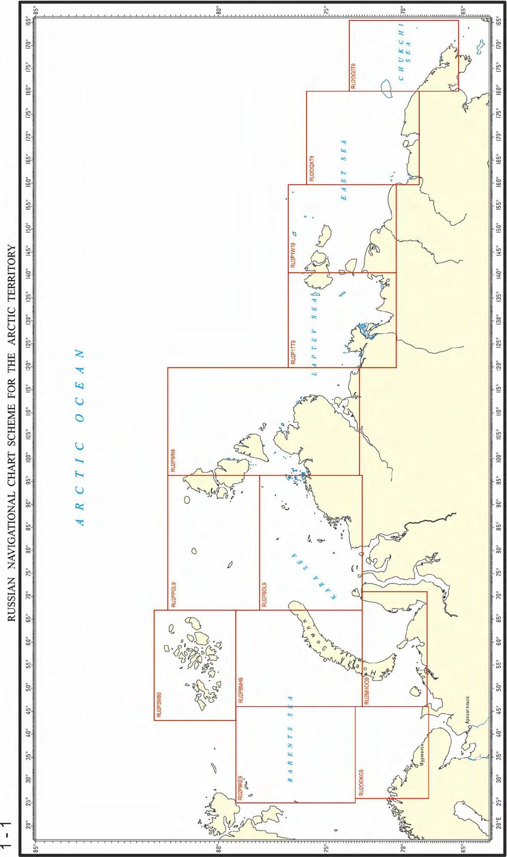
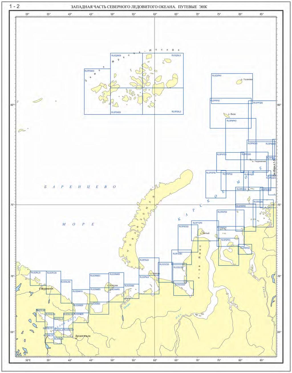
9 ENCs of the Arctic Ocean Nowadays, the cell collection for the seas of Arctic Ocean includes 256 of which: 14 cells on a scale of cell on a scale of cell on a scale of cell on a scale of cell on a scale of cell on a scale of cell on a scale of cell on a scale of cell on a scale of cell on a scale of NATIONAL PAPER CHARTS For waters under jurisdiction of Russia in the Arctic Ocean, the DNO of the MD has a collection of National paper charts, which includes 986 units. With account of scales it is shown by the following way: Central Arctic Basin 1: National charts 1: National charts 1: National charts 1: National charts Scale 1: and larger scales 724
10
11

12
13 REFERENCE ON THE OPERATIVE NAVIGATIONAL INFORMATION SYSTEM IN THE ARCTIC OCEAN MSI transmission for Arctic Regions is realized: S of latitude 76 within international frame of safety SafetyNet from INMARSAT satellites; within NAVTEX-system from available NAVTEX-stations; N of latitude 76 (out of INMARSAT zone of action) radio stations working on international frequencies are planned to use. The Russian Federation has at its disposal three NAVTEX-stations in Arctic Seas: Barents Sea (Murmansk), White Sea (Arkhangel sk), Laptev Sea (Tiksi). Ministry of Transport (Mintrans) plans for the future to put 8 additional NAVTEX-stations into operation along Northern Sea Route. In order to perform functions of area and nation co-ordination in bringing of navigational information to mariners in Arctic Regions, the following zones of responsibility are defined for: Hydrographic Service of Northern Fleet Murmansk PRIP Region (Barents Sea) Information is transmitted by Murmansk NAVTEX-station Arkhangel sk PRIP Region (White Sea). Information is transmitted by Arkhangel sk NAVTEX-station. FSUE (Federal State Unitary Enterprise) «Hydrographic Enterprise» ZAPAD PRIP Region (Western Part of Northern Sea Route) Information is transmitted by Tiksi NAVTEX-station and INMARSAT technical means. VOSTOK PRIP Region (Eastern Part of Northern Sea Route) Information is transmitted by Tiksi NAVTEX-station and INMARSAT technical means. WWNWS NAVAREA XX and NAVAREA XXI Regions (beginning on 1 January, 2001) Information is transmitted by INMARSAT technical means. Besides the Ministry of transport considers possibility to transmit information on international frequencies. Hydrographic Enterprise of Ministry of Transport on behalf of the Russian Federation is entrusted with co-ordinator function for NAVAREA XX and NAVAREA XXI Regions. In November, 2007, changes were made in the Charter of FSUE HE by the order of Federal Agency of Marine and River Transport (No DD-148-r of 26 November 2007, namely the enterprise is entrusted with national coordinator function of collection, preparation and transmission of maritime safety information for WWNWS NAVAREA XX and NAVAREA XXI Regions. Beginning on 1 July, 2010, MSI service of FSUE HE has started to transmit real NAVAREA warnings for NAVAREA XX and NAVAREA XXI Regions (in mode of «Initial Operational Capability» (IOC)).
 further north along the 030 00.00E meridian to: 90 00.00N 030 00.00E, 90 00.00N 125 00.")

14 Arctic NAVAREA/METAREA Boundary limits: NAVAREA/METAREA XX bound by: From the border between Norway and Russia (Inland) to: N E, N E, N E, N E, From this geographical position ( N E) further north along the E meridian to: N E, N E, then south to the Russian Federation coastline along the E meridian; NAVAREA/METAREA XXI bound by: From a geographical position on the Russian Federation coastline at the E meridian to: N E, N W, N W, west to a geographical position on the Russian Federation coastline along the N parallel Arctic NAVAREA Broadcast Schedules: NAVAREA XX (IOR) at 0530UTC and1730utc NAVAREA XXI (POR) at 0630UTC and 1830UC
15 Telephone: fax: , 11 Liniya, B-34 St.Petersburg,
PAKISTAN NATIONAL REPORT
 PAKISTAN NATIONAL REPORT 16 th MEETING NORTH INDIAN OCEAN HYDROGRAPHIC COMMISSION (NIOHC) CHITTAGONG, BANGLADESH 14-16 MARCH 2016 BY PAKISTAN NAVY HYDROGRAPHIC DEPARTMENT HYDROGRAPHIC DEPARTMENT OF PAKISTAN
PARTICIPATION IN THE WMO VOLUNTARY OBSERVING SHIPS (VOS) SCHEME
 SCHEME") INTERNATIONAL MARITIME ORGANIZATION 4 ALBERT EMBANKMENT LONDON SE1 7SR Telephone: 020 7735 7611 Fax: 020 7587 3210 IMO E Ref. T2-OSS/1.4 MSC.1/Circ.1293 10 December 2008 PARTICIPATION IN THE WMO VOLUNTARY
INTERNATIONAL MARITIME ORGANIZATION 4 ALBERT EMBANKMENT LONDON SE1 7SR Telephone: 020 7735 7611 Fax: 020 7587 3210 IMO E Ref. T2-OSS/1.4 MSC.1/Circ.1293 10 December 2008 PARTICIPATION IN THE WMO VOLUNTARY
R E P U B L I C O F C Y P R U S NATIONAL REPORT OF CYPRUS TO THE MEDITERRANEAN AND BLACK SEAS HYDROGRAPHIC COMMISSION (MBSHC)
") R E P U B L I C O F C Y P R U S NATIONAL REPORT OF CYPRUS TO THE MEDITERRANEAN AND BLACK SEAS HYDROGRAPHIC COMMISSION (MBSHC) ISTANBUL MEETING 25-27 SEPTEMBER 2013 NATIONAL REPORT OF CYPRUS TO THE MEDITERRANEAN
R E P U B L I C O F C Y P R U S NATIONAL REPORT OF CYPRUS TO THE MEDITERRANEAN AND BLACK SEAS HYDROGRAPHIC COMMISSION (MBSHC) ISTANBUL MEETING 25-27 SEPTEMBER 2013 NATIONAL REPORT OF CYPRUS TO THE MEDITERRANEAN
ANNEX 23 RESOLUTION MSC.231(82) ADOPTION OF AMENDMENTS TO THE EXISTING MANDATORY SHIP REPORTING SYSTEM IN THE GULF OF FINLAND
 ADOPTION OF AMENDMENTS TO THE EXISTING MANDATORY SHIP REPORTING SYSTEM IN THE GULF OF FINLAND") RESOLUTION MSC.231(82) (adopted on 5 December 2006) ADOPTION OF AMENDMENTS TO THE EXISTING MANDATORY SHIP REPORTING SYSTEM IN THE GULF OF FINLAND THE MARITIME SAFETY COMMITTEE, RECALLING Article 28(b)
RESOLUTION MSC.231(82) (adopted on 5 December 2006) ADOPTION OF AMENDMENTS TO THE EXISTING MANDATORY SHIP REPORTING SYSTEM IN THE GULF OF FINLAND THE MARITIME SAFETY COMMITTEE, RECALLING Article 28(b)
Arctic Regional Hydrographic Commission (ARHC) Portsmouth, New Hampshire, United States, January 29-30, Hydrographic National Report of Denmark
 Portsmouth, New Hampshire, United States, January 29-30, Hydrographic National Report of Denmark") ARHC4-2.2 Arctic Regional Hydrographic Commission (ARHC) Portsmouth, New Hampshire, United States, January 29-30, 2014 Hydrographic National Report of Denmark January 2014 1. Hydrographic Office January
ARHC4-2.2 Arctic Regional Hydrographic Commission (ARHC) Portsmouth, New Hampshire, United States, January 29-30, 2014 Hydrographic National Report of Denmark January 2014 1. Hydrographic Office January
PAKISTAN NATIONAL REPORT. 12 th MEETING NORTH INDIAN OCEAN HYDROGRAPHIC COMMISSION (NIOHC) Colombo, Sri Lanka March 2012
 Colombo, Sri Lanka March 2012") PAKISTAN NATIONAL REPORT 12 th MEETING NORTH INDIAN OCEAN HYDROGRAPHIC COMMISSION (NIOHC) Colombo, Sri Lanka 20-23 March 2012 BY PAKISTAN NAVY HYDROGRAPHIC DEPARTMENT HYDROGRAPHIC DEPARTMENT OF PAKISTAN
PAKISTAN NATIONAL REPORT 12 th MEETING NORTH INDIAN OCEAN HYDROGRAPHIC COMMISSION (NIOHC) Colombo, Sri Lanka 20-23 March 2012 BY PAKISTAN NAVY HYDROGRAPHIC DEPARTMENT HYDROGRAPHIC DEPARTMENT OF PAKISTAN
SUMMARY. Executive Summary: NAVAREA VIII provides the paper of MSI Self Assessment for CPRNW 10
 CPRNW Meeting 10 Agenda Item 3.2.1 CPRNW10/3/2/VIII MSI Self Assessment - NAVAREA VIII Submitted by INDIA SUMMARY Executive Summary: NAVAREA VIII provides the paper of MSI Self Assessment for CPRNW 10
PAKISTAN NAVY HYDROGRAPHIC DEPARTMENT
 PAKISTAN NATIONAL REPORT 5th MEETING ROPME SEA ARAE HYDROGRAPHIC COMMISSION (RASHC) Riyadh, Saudi Arabia 04-06 March 2013 PAKISTAN NAVY HYDROGRAPHIC DEPARTMENT HYDROGRAPHIC DEPARTMENT OF PAKISTAN (NATIONAL
NATIONAL REPORT OF ESTONIA
 BSHC 21 th Conference 27-29 Sept 2016 Klaipeda, Lithuania NATIONAL REPORT OF ESTONIA Executive summary This report summarizes the activities of the Estonian Maritime Administration in the field of hydrography
Marine Notice No. 13 of 2009
 Marine Notice No. 13 of 2009 NOTICE TO ALL SHIPOWNERS, FISHING VESSEL OWNERS, AGENTS, SHIPMASTERS, SHIP MANAGEMENT COMPANIES, SKIPPERS, FISHERMEN, YACHTSMEN AND SEAFARERS. HELP IMPROVE QUALITY OF WEATHER
Meeting July 2018 Agenda Item 7.1. Tsunami Service Provider Messages for the Maritime Community. Submitted by IOC Secretariat SUMMARY
 WWNWS WWNWS10/7/1 Meeting 10 19 July 2018 Agenda Item 7.1 Tsunami Service Provider Messages for the Maritime Community Submitted by IOC Secretariat SUMMARY Executive Summary: This document provides details
PAKISTAN NATIONAL REPORT. 3 rd ROPME Sea Area Hydrographic Commission (RSAHC) Meeting 8 and 9 June Monaco PAKISTAN NAVY HYDROGRAPHIC DEPARTMENT
 Meeting 8 and 9 June Monaco PAKISTAN NAVY HYDROGRAPHIC DEPARTMENT") PAKISTAN NATIONAL REPORT 3 rd ROPME Sea Area Hydrographic Commission (RSAHC) Meeting 8 and 9 June 2009 Monaco PAKISTAN NAVY HYDROGRAPHIC DEPARTMENT HYDROGRAPHIC DEPARTMENT OF PAKISTAN (NATIONAL REPORT
PAKISTAN NATIONAL REPORT 3 rd ROPME Sea Area Hydrographic Commission (RSAHC) Meeting 8 and 9 June 2009 Monaco PAKISTAN NAVY HYDROGRAPHIC DEPARTMENT HYDROGRAPHIC DEPARTMENT OF PAKISTAN (NATIONAL REPORT
Hydrographic National Report of Denmark
 18th Conference Agenda item B.2 Tallinn, Estonia National report 16-18 September 2013 Denmark Hydrographic National Report of Denmark Marts 2013 1. Hydrographic Office January 1, 2013 Kort & Matrikelstyrelsen
Arctic Hydrographic Adequacy an Update
 Arctic Hydrographic Adequacy an Update Lt Cmd. Samuel F. Greenaway 1 and Amber Batts 1,2 1. NOAA Office of Coast Survey Development Lab, Hydrographic Systems & Technology Branch, Silver Spring, Maryland,
THAILAND NATIONAL REPORT
 NIOHC18 TH National Report THAILAND NATIONAL REPORT 18 th NORTH INDIAN OCEAN HYDROGRAPHIC COMMISSION (NIOHC) CONFERENCE Goa, India 9 th 12 th April 2018-1 - CONTENTS 1. Hydrographic Office / Service 3
THAILAND NATIONAL REPORT
 NIOHC14 TH National Report THAILAND NATIONAL REPORT 14 th NORTH INDIAN OCEAN HYDROGRAPHIC COMMISSION (NIOHC) CONFERENCE Bangkok, Thailand 26 th 28 th February 2014 1 CONTENTS 1. Hydrographic Office / Service...
14 th NIOHC, Myanmar National Report MYANMAR NAVAL HYDROGRAPHIC CENTRE (MNHC) NATIONAL REPORT HYDROGRAPHIC DEPARTMENT, ROYAL THAI NAVY-HDRTN
 NATIONAL REPORT HYDROGRAPHIC DEPARTMENT, ROYAL THAI NAVY-HDRTN") 14 th NIOHC, Myanmar National Report MYANMAR NAVAL HYDROGRAPHIC CENTRE (MNHC) NATIONAL REPORT 14 th NORTH INDIAN OCEAN HYDROGRAPHIC COMMISSION CONFERENCE HYDROGRAPHIC DEPARTMENT, ROYAL THAI NAVY-HDRTN
14 th NIOHC, Myanmar National Report MYANMAR NAVAL HYDROGRAPHIC CENTRE (MNHC) NATIONAL REPORT 14 th NORTH INDIAN OCEAN HYDROGRAPHIC COMMISSION CONFERENCE HYDROGRAPHIC DEPARTMENT, ROYAL THAI NAVY-HDRTN
THAILAND NATIONAL REPORT
 NIOHC19 TH National Report THAILAND NATIONAL REPORT 19 th MEETING OF THE NORTH INDIAN OCEAN HYDROGRAPHIC COMMISSION (NIOHC19) MUSCAT, OMAN 25 th 28 th March 2019-1 - CONTENTS 1. Hydrographic Office / Service
PORTUGAL NATIONAL REPORT
 PORTUGAL NATIONAL REPORT 14 TH MEETING OF THE EASTERN ATLANTIC HYDROGRAPHIC COMMISSION Cadiz, Spain 18 th 20 th October 2016 INSTITUTO HIDROGRÁFICO Miguel Arenga IHPT Head of the Hydrography Division 2016-10-18
HYDROGRAPHIC SECTION QATAR NATIONAL REPORT TO THE 6 TH ROPME SEA AREA HYDROGRAPHIC COMMISSION MEETING
 HYDROGRAPHIC SECTION QATAR NATIONAL REPORT TO THE 6 TH ROPME SEA AREA HYDROGRAPHIC COMMISSION MEETING ABU DHABI, UNITED ARAB EMIRATES 9 11 FEBRUARY 2015 Page left intentionally blank 1. Hydrographic Section
CANADIAN HYDROGRAPHIC SERVICE & OCEANOGRAPHIC SERVICES
 CANADIAN HYDROGRAPHIC SERVICE & OCEANOGRAPHIC SERVICES Presentation to Warming of the North Conference Ottawa, March 2 nd, 2015 Denis Hains, Director General & Hydrographer General of Canada TIP OF THE
National Report Suriname 2014
 MARITIEME AUTHORITY SURINAME National Report Suriname 2014 15th MEETING OF THE MESO AMERICAN AND CARIBBEAN SEA HYDROGRAPHIC COMMISSION (MACHC) 10 13 December 2013 Manzanillo, Mexico 1. Hydrographic Office
R E P U B L I C O F C Y P R U S. NATIONAL REPORT OF CYPRUS TO THE 19 th MEDITERRANEAN AND BLACK SEAS HYDROGRAPHIC COMMISSION (MBSHC)
") R E P U B L I C O F C Y P R U S NATIONAL REPORT OF CYPRUS TO THE 19 th MEDITERRANEAN AND BLACK SEAS HYDROGRAPHIC COMMISSION (MBSHC) BATUMI MEETING 30 JUNE TO 02 JULY 2015 NATIONAL REPORT OF CYPRUS TO THE
R E P U B L I C O F C Y P R U S NATIONAL REPORT OF CYPRUS TO THE 19 th MEDITERRANEAN AND BLACK SEAS HYDROGRAPHIC COMMISSION (MBSHC) BATUMI MEETING 30 JUNE TO 02 JULY 2015 NATIONAL REPORT OF CYPRUS TO THE
FOURTH INTERNATIONAL PORT METEOROLOGICAL OFFICERS WORKSHOP AND SUPPORT TO GLOBAL OCEAN OBSERVATIONS USING SHIP LOGISTICS
 FOURTH INTERNATIONAL PORT METEOROLOGICAL OFFICERS WORKSHOP AND SUPPORT TO GLOBAL OCEAN OBSERVATIONS USING SHIP LOGISTICS PMO-IV 8-10 DEC 2010, ORLANDO, FLORIDA, USA 1 This presentation is generally for
ISRAEL NATIONAL REPORT 2015
 State of Israel Ministry of Construction Survey of Israel Geodesy, Cadastre, Hydrography, Mapping and GIS ISRAEL NATIONAL REPORT 2015 to the 19 th MEDITERRANEAN AND BLACK SEA HYDROGRAPHIC COMMISSION (MBSHC)
WMO Liaison Report. Submitted by WMO SUMMARY
 WWNWS WWNWS1/3/3/3 Meeting 1 30 July 2009 Agenda Item 3.3.3 WMO Liaison Report Submitted by WMO SUMMARY Executive Summary: This document provides the report of the major activities, challenges and requirements
NATIONAL REPORT OF POLAND
 NATIONAL REPORT OF Executive summary This report summarizes activities of the Hydrographic Office/Service in the field of hydrography since the previous Baltic Sea Hydrographic Commission 18th Conference
PORTUGAL NATIONAL REPORT
 PORTUGAL NATIONAL REPORT 13 TH SOUTHERN AFRICA AND ISLANDS HYDROGRAPHIC COMMISSION MEETING Cape Town, South Africa 29 th 31 st August 2016 INSTITUTO HIDROGRÁFICO Miguel Arenga IHPT Head of the Hydrography
STATUS QUO REPORT ON ENC ACTIVITIES
 NETWORK OF DANUBE WATERWAY ADMINISTRATIONS South-East European Transnational Cooperation Programme STATUS QUO REPORT ON ENC ACTIVITIES UA - SHS Document ID: Activity: 5.2 Author / Project Partner: Date:
On strategy for the development of the Russian Federation activities in the Antarctic for the period until 2020 and longer-term perspective
 Agenda Item: ATCM 5 Presented by: Original: Russian Federation Russian, English On strategy for the development of the Russian Federation activities in the Antarctic for the period until 2020 and longer-term
Visual Notices to mariners & Navigational Warnings
 Visual Notices to mariners & Navigational Warnings 22 MAY, 2017 Hydrographic and Oceanographic Department Talking about: Visual Notices to Mariners & Navigational Warning System Text on a paper Text information
On establishing the traffic separation schemes, separation of sea corridors and maritime special areas in the territorial sea of Georgia
 THE ORDER OF THE PRESIDENT OF GEORGIA 380 June 21, 2007 Tbilisi On establishing the traffic separation schemes, separation of sea corridors and maritime special areas in the territorial sea of Georgia
Hydrometeorological support of the safety of marine activity in the Arctic
 International Conference "Through the Northern Sea Route to strategic stability in the Arctic" Hydrometeorological support of the safety of marine activity in the Arctic Alexander Frolov Head of Roshydromet
Options in Capacity Building. Underpinning the Blue Economy. Slide 1/78. Derrick R. Peyton. 14 th MACHC Meeting. IIC Technologies. December 9-13, 2013
 Options in Capacity Building Underpinning the Blue Economy Derrick R. Peyton IIC Technologies 14 th MACHC Meeting December 9-13, 2013 Slide 1/78 Overview Blue Economy Defined Challenges (SDI, MSDI, Standards)
The route towards a new GEBCO grid
 The route towards a new GEBCO grid Pauline Weatherall, GEBCO Digital Atlas Manager British Oceanographic Data Centre (BODC) GEBCO TSCOM/SCRUM meeting, Monaco, October 2012 The route towards a new GEBCO
RUSSIAN FEDERATION (EUROPE)
") RUSSIAN FEDERATION (EUROPE) Maritime Radio Station: Arkhangel'sk VI 64 51'N 40 17'E UGE XX North Atlantic to Barents Sea - Arctic coast RT (MF) B 2 595 khz Arkhangel'sk Radio 0510, 0530, 1710, 1730 B Navigational
RUSSIAN FEDERATION (EUROPE) Maritime Radio Station: Arkhangel'sk VI 64 51'N 40 17'E UGE XX North Atlantic to Barents Sea - Arctic coast RT (MF) B 2 595 khz Arkhangel'sk Radio 0510, 0530, 1710, 1730 B Navigational
Baltic Sea Hydrographic Commission 22nd meeting
 Agenda item B3.1 Baltic Sea Hydrographic Commission 22nd meeting Rostock, Germany, 19 21 September 2017 National Report of Denmark August 2017 Executive summary This report gives a summary of the main
Acknowledgments Piloting The Art of Navigation p. 3 The Shipboard Navigation Department Organization p. 6 Duties of the Navigator p.
 Foreword p. xiii Acknowledgments p. xv Piloting The Art of Navigation p. 3 The Shipboard Navigation Department Organization p. 6 Duties of the Navigator p. 7 Relationship of the Navigator to the Command
Baltic Marine Environment Protection Commission
 Baltic Marine Environment Protection Commission Maritime Group Klaipeda, Lithuania, 23-25 November 2015 MARITIME 15-2015 Document title FAMOS Finalising Surveys for the Baltic Motorways of the Sea Code
National Report of Finland
 National Report of 1. Finnish Hydrographic Office The Finnish Hydrographic Office (FHO) is responsible for nautical charting over the Finnish sea area and the most important inland water bodies. This covers
NATIONAL REPORT OF THE HYDROGRAPHIC DEPARTMENT, ROYAL THAI NAVY
 NATIONAL REPORT OF THE HYDROGRAPHIC DEPARTMENT, ROYAL THAI NAVY to 11 th NORTH INDIAN OCEAN HYDROGRAPHIC COMMISSION MEETING NEW DELHI, INDIA 1-2 MARCH 2011 1. Hydrographic Office / Service Established
The role of the Italian Navy Hydrographic Institute in the Arctic activities
 The role of the Italian Navy Hydrographic Institute in the Arctic activities Luigi Sinapi Director of the Italian Hydrographic Institute Early Arctic hydrographic surveys ICE ICE Arctic hydrographic monitoring
Routeing. Voyage preparation, -planning and -implementation
 Routeing Voyage preparation, -planning and -implementation Routeing possibilities Weather routeing By own information By external party Climatologic Routeing By charts and books Weather Routeing Basis
This page intentionally left blank
 Version 3.0.1 October 2011 This page intentionally left blank Copyright Notice Copyright International Hydrographic Organization 2011 This work is copyright. Apart from any use permitted in accordance
This report addresses the Arctic-related activities of the Canadian Hydrographic Service since last ARHC meeting.
 ARHC4-2.1 Canadian Hydrographic Service Report to the 4th meeting of the Arctic Regional Hydrographic Commission January 29-30, 2014 Portsmouth, New Hampshire, USA This report addresses the Arctic-related
REPORT BY THE HYDROGRAPHIC AND GEODETIC SERVICE OF THE REPUBLIC OF CUBA. 18 th MESO AMERICAN AND CARIBBEAN SEA HYDROGRAPHIC COMMISSION MEETING
 REPORT BY THE HYDROGRAPHIC AND GEODETIC SERVICE OF THE REPUBLIC OF CUBA 18 th MESO AMERICAN AND CARIBBEAN SEA HYDROGRAPHIC COMMISSION MEETING 1. STRUCTURE OF THE HYDROGRAPHIC AND GEODETIC SERVICE OF THE
Maritime Standards. Rafael Ponce Tom De Puyt
 Maritime Standards Rafael Ponce Tom De Puyt Content The International Hydrographic Organization - Overview - Existing Support - Committees and Working Groups - Technology - Runtime - MCS Next Generation
NATIONAL REPORT OF UKRAINE TO 16 th CONFERENCE OF THE MEDITERRANEAN AND BLACK SEAS HYDROGRAPHIC COMMISSION (MBSHC)
") NATIONAL REPORT OF UKRAINE TO 16 th CONFERENCE OF THE MEDITERRANEAN AND BLACK SEAS HYDROGRAPHIC COMMISSION (MBSHC) 1. Hydrographic Service a) State Hydrographic Service of Ukraine (SHS) is the national
NATIONAL REPORT OF UKRAINE TO 16 th CONFERENCE OF THE MEDITERRANEAN AND BLACK SEAS HYDROGRAPHIC COMMISSION (MBSHC) 1. Hydrographic Service a) State Hydrographic Service of Ukraine (SHS) is the national
NATIONAL REPORT TO THE 7 TH SOUTHERN AFRICAN AND ISLANDS HYDROGRAPHIC COMMISSION
 THE UNITED REPUBLIC OF TANZANIA SAIHC7-5.3M NATIONAL REPORT TO THE 7 TH SOUTHERN AFRICAN AND ISLANDS HYDROGRAPHIC COMMISSION TO BE HELD IN LA REUNION, 14 TH 17 TH SEPTEMBER, 2009 PREPARED BY IGNATIOUS
Guide for planning international transit voyages on the NSR
 The Arctic 2030 Project: Feasibility and Reliability of Shipping on the Northern Sea Route and Modeling of an Arctic Marine Transportation & Logistics System 1-st Industry Seminar: NSR s Legislation, Tariff
Efficiencies in Data Acquisition and Transformation
 Efficiencies in Data Acquisition and Transformation Andrew LEYZACK Canada Key words: Hydrography, IHO S-57, Nautical Chart SUMMARY For many hydrographic offices, the introduction of electronic nautical
The STATE HYDROGRAPHIC SERVICE OF GEORGIA
 The STATE HYDROGRAPHIC SERVICE OF GEORGIA NATIONAL REPORT OF GEORGIA TO 11th MEETING OF THE WORKING GROUP ON THE SAFETY OF NAVIGATION IN THE BLACK AND AZOV SEAS (BASWG11) The STATE HYDROGRAPHIC SERVICE
SOUTH AFRICAN NAVY HYDROGRAPHIC OFFICE
 SOUTH AFRICAN NAVY HYDROGRAPHIC OFFICE GLOSS National Report for South Africa 2011 Compiled by Ms Ruth Farre Superintendent Tidal Information 1. Introduction The South African coastline is approximately
IHO HYDROGRAPHIC COMMISION ON ANTARCTICA (HCA) 9 th Meeting, Simon's Town, Cape Town, South Africa, October 2009
 9 th Meeting, Simon's Town, Cape Town, South Africa, October 2009") HCA9-07.4Ac IHO HYDROGRAPHIC COMMISION ON ANTARCTICA (HCA) 9 th Meeting, Simon's Town, Cape Town, South Africa, 12-14 October 2009 National Report - JAPAN Hydrographic and Oceanographic Department of Japan
HCA9-07.4Ac IHO HYDROGRAPHIC COMMISION ON ANTARCTICA (HCA) 9 th Meeting, Simon's Town, Cape Town, South Africa, 12-14 October 2009 National Report - JAPAN Hydrographic and Oceanographic Department of Japan
This page intentionally left blank
 Version 3.0.6 December 2016 1 This page intentionally left blank 2 Copyright Notice Copyright International Hydrographic Organization 2016 This work is copyright. Apart from any use permitted in accordance
BRÂNDUŞA CHIOTOROIU 1, E. ȘEMȘEDIN 2
 Riscuri şi catastrofe, an XV, vol. 19, nr. 2/2016 Information on weather and sea conditions onboard polar cruise ships BRÂNDUŞA CHIOTOROIU 1, E. ȘEMȘEDIN 2 ABSTRACT. Information on weather and sea conditions
IMO ROUTEING OF SHIPS, SHIP REPORTING AND RELATED MATTERS. Amendments to the existing mandatory ship reporting system In the Gulf of Finland
 INTERNATIONAL MARITIME ORGANIZATION E IMO SUB-COMMITTEE ON SAFETY OF NAVIGATION 52nd session Agenda item 3 NAV 52/3/5 12 April 2006 Original: ENGLISH ROUTEING OF SHIPS, SHIP REPORTING AND RELATED MATTERS
Global Geospatial Information Management in Tunisia Situation and Future prospects
 Republic of Tunisia Ministry of National Defense National Mapping and Remote Sensing Center (NMRC) Global Geospatial Information Management in Tunisia Situation and Future prospects Qatar, February 2013
National Report of Finland
 of Executive Summary This Report highlights the main activities and achievements of the Finnish Hydrographic Office since BSHC 22 nd Conference in September 2017. - The amount of Hydrographic surveys has
Second Session of the Pan-Arctic Regional Climate Outlook Forum (PARCOF-2), virtual forum, October 2018
, virtual forum, October 2018") Second Session of the Pan-Arctic Regional Climate Outlook Forum (PARCOF-2), virtual forum, October 2018 Consensus Statement for the Arctic Winter 2018-2019 Season Outlook Climate change in the Arctic is
Second Session of the Pan-Arctic Regional Climate Outlook Forum (PARCOF-2), virtual forum, October 2018 Consensus Statement for the Arctic Winter 2018-2019 Season Outlook Climate change in the Arctic is
IHO Input to the Report of the UN Secretary General on Oceans and Law of the Sea Executive Summary General
 IHO Input to the Report of the UN Secretary General on Oceans and Law of the Sea The following notes provide information on activities of the International Hydrographic Organization that are relevant to
STATUS QUO REPORT ON ENC ACTIVITIES
 NETWORK OF DANUBE WATERWAY ADMINISTRATIONS South-East European Transnational Cooperation Programme STATUS QUO REPORT ON ENC ACTIVITIES UA - ONMA Document ID: Activity: 5.2 Author / Project Partner: Date:
VOYAGE (PASSAGE) PLANNING
 PLANNING") VOYAGE (PASSAGE) PLANNING Introduction O Passage planning or voyage planning is a procedure of developing a complete description of a vessel's voyage from start to finish. O Production of a passage plan
VOYAGE (PASSAGE) PLANNING Introduction O Passage planning or voyage planning is a procedure of developing a complete description of a vessel's voyage from start to finish. O Production of a passage plan
SCIENCE OF TSUNAMI HAZARDS
 SCIENCE OF TSUNAMI HAZARDS ISSN 8755-6839 Journal of Tsunami Society International Volume 32 Number 1 2013 THE FRENCH TSUNAMI WARNING CENTER FOR THE MEDITERRANEAN AND NORTHEAST ATLANTIC: CENALT P. Roudil,
Sea Level Monitoring and the GLOSS Programme
 Sea Level Monitoring and the GLOSS Programme Philip L. Woodworth Permanent Service for Mean Sea Level Proudman Oceanographic Laboratory, UK Port Meteorological Officers Meeting, IMO, 25 July 2003 www.pol.ac.uk
Prepared by the North American Ice Service. 4 December Seasonal Outlook Great Lakes Winter
 Prepared by the North American Ice Service A collaboration of the Canadian Ice Service and the National/Naval Ice Center 4 December 2008 Seasonal Outlook Great Lakes Winter 2008-2009 - 1 - Table of contents
09 November 2017 (Week ) NEW BRITISH ADMIRALTY PUBLICATIONS AVAILABLE NOW
 NEW BRITISH ADMIRALTY PUBLICATIONS AVAILABLE NOW") 09 November 2017 (Week 45 2017) NEW BRITISH ADMIRALTY PUBLICATIONS AVAILABLE NOW CODE TITLE AVAILABLE PRICE GBP NP057B Norway Pilot Volume 2B, 10th Edition, 2017 WK 45/17 60.60 NP207-18 ADMIRALTY Tide
09 November 2017 (Week 45 2017) NEW BRITISH ADMIRALTY PUBLICATIONS AVAILABLE NOW CODE TITLE AVAILABLE PRICE GBP NP057B Norway Pilot Volume 2B, 10th Edition, 2017 WK 45/17 60.60 NP207-18 ADMIRALTY Tide
Finnish Maritime Administration BULLETIN 5/
 Finnish Maritime Administration BULLETIN 5/23.5.2008 VOLUNTARY BALLAST WATER EXCHANGE IN THE NORTH-EAST ATLANTIC AND THE BALTIC SEA Invasive non-indigenous species, contained in ships ballast water, may
Hydrographic National Report of Denmark
 Hydrographic National Report of Denmark April 2008 1. Hydrographic Office The present report outlines and summaries the activities carried out in 2007 by The Danish Maritime Safety Administration, and
IHO STAKEHOLDERS FORUM. Hydrographic data and its role in MSDI. Thursday 27 September Jens Peter Hartmann KMS
 IHO STAKEHOLDERS FORUM Hydrographic data and its role in MSDI Thursday 27 September Jens Peter Hartmann KMS Agenda Traditional approach to hydrographic data Expectations within the marine / maritime field
Seatrack Web Developments
 Seatrack Web Seatrack Web Developments HELCOM RESPONSE 16/2012, 21 November 2012 Johan Mattsson, DCOO Seatrack Web Contents Short overview Recent developments Online demonstration (experimental) Questions
Pan American Institute of Geography and History. 12th MACHC 5-9 December 2011
 Pan American Institute of Geography and History 12th MACHC 5-9 December 2011 1 PAIGH Mission and Objectives To encourage, coordinate, and publicize cartographical, geographical, geophysical and historical
P1.25 DATABASE FOR ECOLOGICAL STUDIES OF THE ARCTIC SEAS: BARENTS, KARA, LAPTEV, AND WHITE SEAS ( )
") P1.25 DATABASE FOR ECOLOGICAL STUDIES OF THE ARCTIC SEAS: BARENTS, KARA, LAPTEV, AND WHITE SEAS (181-21) I. Smolyar*, R. Locarnini, R. Tatusko, T. Boyer, S. Levitus (Ocean Climate Laboratory, NOAA/NESDIS/NODC)
P1.25 DATABASE FOR ECOLOGICAL STUDIES OF THE ARCTIC SEAS: BARENTS, KARA, LAPTEV, AND WHITE SEAS (181-21) I. Smolyar*, R. Locarnini, R. Tatusko, T. Boyer, S. Levitus (Ocean Climate Laboratory, NOAA/NESDIS/NODC)
Maritime Weather Information: Automatic Reporting, A New Paradigm
 Maritime Weather Information: Automatic Reporting, A New Paradigm Joe Sienkiewicz, NOAA/NWS Ocean Prediction Center Responsibilities under SOLAS Met Services Contracting governments Observations Limited
[50/16] WMO SURVEY. Admiralty Charts affected by the Publication List
![[50/16] WMO SURVEY. Admiralty Charts affected by the Publication List](/thumbs/91/106481495.jpg "[50/16] WMO SURVEY. Admiralty Charts affected by the Publication List") Admiralty Charts affected by the Publication List [50/16] Admiralty Chart Admiralty Chart 410 AUS 58 536 AUS 60 1444 AUS 510 1534 AUS 621 1535 INT 1160 2014 INT 1201 2015 INT 1202 2018 INT 1218 2040 INT
Admiralty Charts affected by the Publication List [50/16] Admiralty Chart Admiralty Chart 410 AUS 58 536 AUS 60 1444 AUS 510 1534 AUS 621 1535 INT 1160 2014 INT 1201 2015 INT 1202 2018 INT 1218 2040 INT
CANADIAN HYDROGRAPHIC SERVICE
 CANADIAN HYDROGRAPHIC SERVICE Surveying and Charting Canada s Waters Since 1883 Ilulisat Maritime Workshop 2017 The Importance and Need for Hydrography Denis Hains, Hydrographer General of Canada & Director
noaa fisheries service
 Science, Service, Stewardship Compliance Guide for Right Whale Ship Strike Reduction Rule (50 CFR 224.105) noaa fisheries service Mandatory speed restrictions of 10 knots or less are required in Seasonal
Bathymetry. EMODnet Stakeholder Conference & Sea-basin Workshops February Bathymetry
 EMODnet Stakeholder Conference & Sea-basin Workshops 14-15 February 2017 Arctic checkpoint Belinda Kater On behalf of all Checkpoints http://www.emodnet.eu 1 ? is the study of the "beds" or "floors" of
Future Ocean Floor Mapping: Ocean Stewardship & Initial Industry Contributions. U.S Hydro Galveston, TX March 23, 2017 David Millar - Fugro
 Future Ocean Floor Mapping: Ocean Stewardship & Initial Industry Contributions U.S Hydro 2017 - Galveston, TX March 23, 2017 David Millar - Fugro Presentation Outline The Need for Ocean Mapping GEBCO GEBCO
1.1 GENERAL 1.2 COMMUNICATIONS. Icebreaking and Shipping Support Services ICEBREAKING AND SHIPPING SUPPORT SERVICES
 Canadian Coast Guard Ice Navigation in Canadian Waters CHAPTER 1 ICEBREAKING AND SHIPPING SUPPORT SERVICES 1.1 GENERAL There are a variety of icebreaking and support services available to ships transiting
Coast Survey Providing Improved Access to Maritime Navigation Products and Services
 Coast Survey Providing Improved Access to Maritime Navigation Products and Services Kurt A. Nelson, Branch Chief CGTP Leland Snyder, Branch Chief FADS Office of Coast Survey Agenda Current Coast Survey
Council conclusions on Arctic issues. 2985th FOREIGN AFFAIRS Council meeting Brussels, 8 December 2009
 COU CIL OF THE EUROPEA U IO EN Council conclusions on Arctic issues 2985th FOREIGN AFFAIRS Council meeting Brussels, 8 December 2009 The Council adopted the following conclusions: The Council recalls its
No JANUARY 2014 UNITED STATES OF AMERICA. Contents
 2 11 JANUARY 2014 UNITED STATES OF AMERICA Published Weekly by the National Geospatial-Intelligence Agency Prepared Jointly with the National Ocean Service and U.S. Coast Guard Contents Section I Chart
Tore Henriksen a & Geir Ulfstein b a Faculty of Law, University of Tromsø, Tromsø, Norway. Available online: 18 Feb 2011
 This article was downloaded by: [Bibliotheek van het Vredespaleis] On: 03 May 2012, At: 03:44 Publisher: Taylor & Francis Informa Ltd Registered in England and Wales Registered Number: 1072954 Registered
National / Naval Ice Center (NIC) Operations Brief This brief is UNCLASSIFIED
 Operations Brief This brief is UNCLASSIFIED") National / Naval Ice Center (NIC) Operations Brief This brief is UNCLASSIFIED Christopher Szorc, Senior Ice Analyst/Forecaster USCG USN NOAA Outline NIC s mission is to provide timely, accurate and relevant
National / Naval Ice Center (NIC) Operations Brief This brief is UNCLASSIFIED Christopher Szorc, Senior Ice Analyst/Forecaster USCG USN NOAA Outline NIC s mission is to provide timely, accurate and relevant
Navigation: Maritime Safety Information (MSI)
") MARINE GUIDANCE NOTE MGN 375 (M+F) Navigation: Maritime Safety Information (MSI) Notice to all Shipowners, Masters, Superintendents and Skippers of Fishing Vessels, Yachts and Other Seagoing Craft This
MARINE GUIDANCE NOTE MGN 375 (M+F) Navigation: Maritime Safety Information (MSI) Notice to all Shipowners, Masters, Superintendents and Skippers of Fishing Vessels, Yachts and Other Seagoing Craft This
NATIONAL HYDROMETEOROLOGICAL SERVICE OF REPUBLIC KAZAKHSTAN
 KAZHYDROMET- NATIONAL HYDROMETEOROLOGICAL SERVICE OF REPUBLIC KAZAKHSTAN ASTANA, 2010 The ministry of preservation of the environment of Republic Kazakhstan The republican State Enterprise «Kazhydromet»
Current Hydrographic Projects at BSH
 7 th Workshop Seabed Acoustics, Rostock, November 19/20, 2015 P01-1 Current Hydrographic Projects at BSH Thomas Dehling Federal Maritime and Hydrographic Agency (BSH) Germany Contact Address Website BSH
Updating the GEBCO_08 Grid with regional compilations and surveys
 Updating the GEBCO_08 Grid with regional compilations and surveys Pauline Weatherall, GEBCO Digital Atlas Manager, British Oceanographic Data Centre (BODC) GEBCO TSCOM/iSCRUM meeting, SIO, October 2011
Produced by Canadian Ice Service of. 2 December Seasonal Outlook Gulf of St Lawrence and East Newfoundland Waters Winter
 Environment Canada Environnement Canada Produced by Canadian Ice Service of Environment Canada 2 December 2010 Seasonal Outlook Gulf of St Lawrence and East Newfoundland Waters Winter 2010-2011 2010 Canadian
Ocean Observation from Haiyang Satellites:
 SPACE SCIENCE ACTIVITIES IN CHINA Ocean Observation from Haiyang Satellites: 2012 2014 AUTHORS JIANG Xingwei LIN Mingsen National Satellite Ocean Application Service, Beijing 100081 ABSTRACT During 2012
Ice surveys, meteorological and oceanographic data What is available and up-to-date?
 Ice surveys, meteorological and oceanographic data What is available and up-to-date? Leader of the Norwegian Ice Service +47 77 62 13 15 - nick.hughes@met.no Norwegian Meteorological Institute met.no 1
The Arctic - A New Frontier The geological, environmental and engineering challenges for submarine telecommunication cables
 The Arctic - A New Frontier The geological, environmental and engineering challenges for submarine telecommunication cables Ryan Wopschall 5 September 2013 Oceanology International China, Shanghai Fugro
INTEGRATION OF HYDROGRAPHIC AND TOPOGRAPHIC DATA FOR COASTAL GIS SOLUTIONS
 Integration of data for coastal GIS INTEGRATION OF HYDROGRAPHIC AND TOPOGRAPHIC DATA FOR COASTAL GIS SOLUTIONS Igor KARNIČNIK (Geodetic Institute of Slovenia, Jamova 2, Ljubljana, Slovenia; igor.karnicnik@geod-is.si)
Coordinates : A - of midpoint or summit : Lat., Long. } to. Description (kind of feature) : seachannel
 : seachannel") INTERNATIONAL HYDROGRAPHIC ORGANIZATION INTERGOVERNMENTAL OCEANOGRAPHIC COMMISSION (of UNESCO) IHO/IOC Form No. 1 UNDERSEA FEATURE NAME PROPOSAL (See NOTE overleaf) Ocean or Sea Japan Sea Name proposed
INTERNATIONAL HYDROGRAPHIC ORGANIZATION INTERGOVERNMENTAL OCEANOGRAPHIC COMMISSION (of UNESCO) IHO/IOC Form No. 1 UNDERSEA FEATURE NAME PROPOSAL (See NOTE overleaf) Ocean or Sea Japan Sea Name proposed
[03/18] Admiralty Charts affected by the Publication List. denotes chart available in the Admiralty Raster Chart Service series. 1.
![[03/18] Admiralty Charts affected by the Publication List. denotes chart available in the Admiralty Raster Chart Service series. 1.](/thumbs/77/75945417.jpg "[03/18] Admiralty Charts affected by the Publication List. denotes chart available in the Admiralty Raster Chart Service series. 1.") Admiralty Charts affected by the Publication List [03/18] Admiralty Charts International Charts 107 INT 1040 129 INT 1041 134 INT 1146 275 INT 1148 281 INT 1152 286 INT 1400 288 INT 1401 299 INT 1402 777
Admiralty Charts affected by the Publication List [03/18] Admiralty Charts International Charts 107 INT 1040 129 INT 1041 134 INT 1146 275 INT 1148 281 INT 1152 286 INT 1400 288 INT 1401 299 INT 1402 777
Updating the GEBCO Grid
 Updating the GEBCO Grid PAULINE WEATHERALL, GEBCO DIGITAL ATLAS MANAGER, BRITISH OCEANOGRAPHIC DATA CENTRE (BODC), NATIONAL OCEANOGRAPHY CENTRE (NOC), LIVERPOOL, UK. GEBCO TSCOM and SCRUM meeting, Kuala
NOAA Nautical Charts and Coastal and Marine Spatial Planning. Meredith Westington Chief Geographer NOAA/NOS/Office of Coast Survey
 NOAA Nautical Charts and Coastal and Marine Spatial Planning Meredith Westington Chief Geographer NOAA/NOS/Office of Coast Survey Ocean Policy Task Force What is CMSP? A comprehensive, adaptive, integrated,
Marine environment monitoring : The basic requirements to support Marine Renewable Energies
 Marine environment monitoring : The basic requirements to support Marine Renewable Energies SHOM in brief SHOM is the French Government agency in charge of Hydrography and Oceanography SHOM s vocation
UNDERSEA FEATURE NAME PROPOSAL. Name Proposed: Kiminu Seamount. to Long.
 INTERNATIONAL HYDROGRAPHIC ORGANIZATION INTERNATIONAL OCEANOGRAPHIC COMMISSION (of UNESCO) UNDERSEA FEATURE NAME PROPOSAL Ocean or Sea: East Sea Name Proposed: Coordinates: A of midpoint or summit: Lat.