VOYAGE (PASSAGE) PLANNING
|
|
|
- Alicia Turner
- 5 years ago
- Views:
Transcription
1 VOYAGE (PASSAGE) PLANNING
2 Introduction O Passage planning or voyage planning is a procedure of developing a complete description of a vessel's voyage from start to finish. O Production of a passage plan prior to departure is a legal requirement. O The practice of voyage planning has evolved from drawing lines on nautical charts to a process of risk management.
3 What to include? The plan should include: O leaving the dock and harbor area, O the enroute portion of a voyage, O approaching the destination, O and mooring.
4 How to do it? Passage planning consists of four stages: O appraisal, O planning, O execution, O and monitoring
5 Appraisal The appraisal stage consists of gathering and contemplating all information relevant to the voyage. By consulting: O nautical charts, O nautical publications and O performing tasks such as O weather forecasting, O prediction of tides and currents, and O checking of local regulations and warnings.

6
7 Planning The process involves projecting various future events including landfalls, narrow passages, and course changes expected during the voyage. The mental model becomes the standard by which later on the navigator measures progress toward the goal.
8 Planning The plan should include the following factors: O the plotting of the intended route on appropriate scale charts O the main elements to ensure safety of life at sea, safety and efficiency of navigation, and protection of the marine environment during the voyage O safe speed, O necessary speed alterations en route, O minimum clearance required under the keel in critical areas with restricted water depth, O course alteration points etc.
9 Execution A number of tasks has to be executed during the course of the voyage. The captain's responsibility is to treat the plan as a "living document" and to review or change it in case of any special circumstances that should arise.
10 Execution Factors which should be taken into account when executing the plan, or deciding on any changes of it include: O the reliability and condition of the vessel's navigational equipment, O estimated times of arrival at critical points for tide heights and flow, O meteorological conditions, O daytime versus night-time passing of danger points, and O traffic conditions, especially at navigational focal points.
11 Monitoring Once the voyage has begun the progress of the vessel along its planned route must be monitored. This requires that the ship's position be determined.
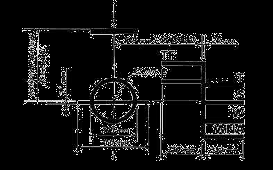
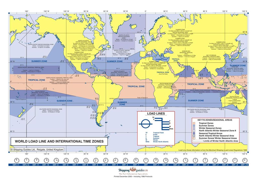
12 Load Line
13
14 Economic aspect The economic objectives of time and distance saving are to be secondary to safe navigation, and are to be ignored whenever the master assesses it necessary.


15 O NavTools Route XP Computer aids O Global fleet control O - PC-Planner


16 Deviations O Results that are different to the planned ones O Can occur on daily basis

, O fuel price changes, O hull or")
17 Deviations It is importnat to determine their source: O internal or O external reasons. Possible reasons for deviations in maritime tr.: O bad weather conditions, O delays in ports, O route deviations (eg. due to medical condition of crew memeber), O fuel price changes, O hull or engine condition, O poor planning etc.

18 WEATHER ROUTEING The selection of best route that accounts for: O Weather forecasts O Estimated sea conditions O Vessel characteristics
19 Sources of Information O Pilot Chart Atlases O Routeing Charts O Admiralty Sailing Directions O Ocean Passages for the World O Monthly Climate Charts O Weather Forecasts and Synopsis
20 Simplified Ship Performance Curves Generally derived from either scale-modelling or from a ship s logbook data. Following Sea Ship Speed Beam Sea Wave Height Head Sea
21 Climatic Considerations O Recommended routes O Vessel type & condition (loaded/ ballast) O Time of year anticipated weather O Probability of gales & fog O Is vessel ice strengthened? O Direction & rate of ocean currents. O Operations to be conducted en-route.
22 Types of Route Available Can be ship based or shore based. Services are available under the following general headings (Types of Routes): O Least Time Tankers & bulk carriers cargoes relatively robust. Urgent Cargo delivery O Least Damage Time not a priority- sensitive cargoes. Live animals, towing, etc. O Least Time with Least Damage A compromise, but the main focus is reducing damage. O Constant Speed To comply with charter party stipulations. Port arrival time pre-arranged. O Fuel Saving O Towing Generally involves avoiding head seas, market driven, e.g. high bunkers price. Usually involves advice upon sailing date & time. Special speed and or manoeuvring requirements.

23 Using a Wave Details Chart
24 Construction of a Least Time Track O 1) Mark destination & GC track on polar stereographic/gnomic chart. Plot GC track to Destination
25 Construction of a Least Time Track Use wave height forecast for next 12 hour and ship s performance curves to lay-off 12 hour distance at approximately 10 intervals. Head Sea
26 Repeat the calculation for 10 intervals & construct time front for next 12 hours. O 12 Hour Time Front or Position Locus Positions Too far from the GC are rejected At this stage

27 Choosing points on the 12 hour time front, construct a time front for the next 24 hours.
28 The process is repeated for all available 12/24 hour forecasts. Recommended Route Closest Point Following Sea Last Time Front Head Sea
29 Current Charts Three main types: O Current Rose Charts O Vector Mean Current Charts O Predominant Current Charts

30 Current Rose Chart
31 Vector Mean Chart
32 Predominant Current Chart
33 Shore Based Routeing O Advantages O Access of operatives to a wide range of information. O Personnel are experts in analysing the above. O Tends to save money on longer voyages- over 1500 miles. O Considerations O Weather needs to be a major factor in route choice. O Few navigation restrictions along the route. O Extremes of weather occurring in changing patterns along the track.
34 Ship Based Routeing O The Master uses his/her experience to route the vessel utilising the information that can be obtained by FAX machine, websites and other media. O Master has ultimate responsibility for the safety of the crew, ship and cargo. O Master is in situ (at the location) O Master is fully aware of the effect of the environment on the vessel O Master has fewer resources
35 Other Factors To Consider when deciding on Routeing 1. Navigational factors such as under keel clearance (UKC) 2. Ballast or loaded passage 3. Ocean currents 4. Areas of fog (reduced speed) 5. Ice limits (danger, reduced speed, ice class/ strengthened) 6. Ice accretion 7. Length of voyage (Over 1,500 nm) 8. East or Westbound (Westbound will have seas on bow) 9. Latitude (Mid Latitude) 10. Charter party limitations
36 Problems with weather routeing. O Forecast Accuracy Affected by the problems of obtaining data as inaccurate location of the storm centre affects the accuracy of wave height predictions. Quality of data can vary with geographical area. O Ship Performance Curves Based on observation of waves-difficult to ascertain. Also difficult to measure the ship s speed. O Swell & Waves May not be a simple trochoidal shape (i.e. irregular waves affect the way in which a ship will be affected slamming, etc.)
37 Usefulness of Weather Routeing O Claimed Benefits O Saves Fuel O Damage Reduction vessels & cargo O Voyage Time Reduced O Comfortable experience for people O Effectiveness O Voyages 1500 miles+ O Weather a major factor-extreme conditions with changing patterns O Waters clear of navigational dangers (plenty of searoom). O Westbound in middle latitudes most effective
38 Usefulness to Fleet Managers O Can provide good quality weather forecasts and reports. O Enables the vessels progress and position to be monitored more closely O Monitor Ship and Fleet Status O Monitor ETAs O Monitor actual ship performance O Improve environmental performance fuel virtual arrival, efficiency, etc. O Can provide quality historical data for analysis
Page 1. A Grieg Group Company
 Page 1 ECDIS PAST, PRESENT & Future 2000-2010 Past Present 2010-2015 2015... Future Page 2 History Page 3 DEEPLY - Past What is going on there????? I am Checking now Sir Page 4 ECDIS History ECDIS has
Digitalization in Shipping
 Digitalization in Shipping Tom Sundell VP Products, NAPA www.napa.fi NAPA Solutions for Safe and Efficient Ship Operations NAPA A very short introduction to NAPA NAPA for safety and efficiency of the industry
ANNEX 23 RESOLUTION MSC.231(82) ADOPTION OF AMENDMENTS TO THE EXISTING MANDATORY SHIP REPORTING SYSTEM IN THE GULF OF FINLAND
 ADOPTION OF AMENDMENTS TO THE EXISTING MANDATORY SHIP REPORTING SYSTEM IN THE GULF OF FINLAND") RESOLUTION MSC.231(82) (adopted on 5 December 2006) ADOPTION OF AMENDMENTS TO THE EXISTING MANDATORY SHIP REPORTING SYSTEM IN THE GULF OF FINLAND THE MARITIME SAFETY COMMITTEE, RECALLING Article 28(b)
RESOLUTION MSC.231(82) (adopted on 5 December 2006) ADOPTION OF AMENDMENTS TO THE EXISTING MANDATORY SHIP REPORTING SYSTEM IN THE GULF OF FINLAND THE MARITIME SAFETY COMMITTEE, RECALLING Article 28(b)
Routeing. Voyage preparation, -planning and -implementation
 Routeing Voyage preparation, -planning and -implementation Routeing possibilities Weather routeing By own information By external party Climatologic Routeing By charts and books Weather Routeing Basis
Higher National Unit Specification. General information for centres. Applied Marine Meteorology. Unit code: F0LP 35
 Higher National Unit Specification General information for centres Unit title: Applied Marine Meteorology Unit code: F0LP 35 Unit purpose: This Unit is about interpreting and evaluating meteorological,
On an Advanced Shipboard Information and Decision-making System for Safe and Efficient Passage Planning
 International Journal on Marine Navigation and Safety of Sea Transportation Volume 2 Number 1 March 28 On an Advanced Shipboard Information and Decision-making System for Safe and Efficient Passage Planning
PARTICIPATION IN THE WMO VOLUNTARY OBSERVING SHIPS (VOS) SCHEME
 SCHEME") INTERNATIONAL MARITIME ORGANIZATION 4 ALBERT EMBANKMENT LONDON SE1 7SR Telephone: 020 7735 7611 Fax: 020 7587 3210 IMO E Ref. T2-OSS/1.4 MSC.1/Circ.1293 10 December 2008 PARTICIPATION IN THE WMO VOLUNTARY
INTERNATIONAL MARITIME ORGANIZATION 4 ALBERT EMBANKMENT LONDON SE1 7SR Telephone: 020 7735 7611 Fax: 020 7587 3210 IMO E Ref. T2-OSS/1.4 MSC.1/Circ.1293 10 December 2008 PARTICIPATION IN THE WMO VOLUNTARY
Quick Reference Manual. Ver. 1.3
 Quick Reference Manual Ver. 1.3 1 EXASITE Voyage EXSITE Voyage is a web-based communication tool designed to support the following users; Ship operators who utilize Optimum Ship Routing (OSR) service in
Maritime Weather Information: Automatic Reporting, A New Paradigm
 Maritime Weather Information: Automatic Reporting, A New Paradigm Joe Sienkiewicz, NOAA/NWS Ocean Prediction Center Responsibilities under SOLAS Met Services Contracting governments Observations Limited
Marine Notice No. 13 of 2009
 Marine Notice No. 13 of 2009 NOTICE TO ALL SHIPOWNERS, FISHING VESSEL OWNERS, AGENTS, SHIPMASTERS, SHIP MANAGEMENT COMPANIES, SKIPPERS, FISHERMEN, YACHTSMEN AND SEAFARERS. HELP IMPROVE QUALITY OF WEATHER
Maciej Szymański, Bernard Wiśniewski
 Scientific Journals of the Maritime University of Szczecin Zeszyty Naukowe Akademii Morskiej w Szczecinie 2016, 48 (120), 182 186 ISSN 1733-8670 (Printed) Received: 29.04.2016 ISSN 2392-0378 (Online) Accepted:
CHAPTER 37 WEATHER ROUTING
 CHAPTER 37 WEATHER ROUTING PRINCIPLES OF WEATHER ROUTING 3700. Introduction Ship weather routing develops an optimum track for ocean voyages based on forecasts of weather, sea conditions, and a ship s
ADOPTED ISOCHRONES METHOD IMPROVING SHIP SAFETY IN WEATHER ROUTING WITH EVOLUTIONARY APPROACH
 ADOPTED ISOCHRONES METHOD IMPROVING SHIP SAFETY Szłapczyńska Joanna, Śmierzchalski Roman Maritime University, Gdynia, Poland Keywords weather routing, isochrones method Abstract The paper is focused on
CANADIAN HYDROGRAPHIC SERVICE & OCEANOGRAPHIC SERVICES
 CANADIAN HYDROGRAPHIC SERVICE & OCEANOGRAPHIC SERVICES Presentation to Warming of the North Conference Ottawa, March 2 nd, 2015 Denis Hains, Director General & Hydrographer General of Canada TIP OF THE
Maritime Safety Services. Supporting Safe and Efficient Transfer Operations
 Maritime Safety Services Supporting Safe and Efficient Transfer Operations Charles Tait 06 Ship to Ship (STS) Transfer is a critical and important, daily activity in the support of, and delivery of, Offshore
CHAPTER 41 WEATHER ROUTING
 CHAPTER 41 WEATHER ROUTING PRINCIPLES OF WEATHER ROUTING 4100. Introduction Ship weather routing develops an optimum track for ocean voyages based on forecasts of weather, sea conditions, and a ship s
Guide for planning international transit voyages on the NSR
 The Arctic 2030 Project: Feasibility and Reliability of Shipping on the Northern Sea Route and Modeling of an Arctic Marine Transportation & Logistics System 1-st Industry Seminar: NSR s Legislation, Tariff
Ship weather routing using pathfinding algorithms: the case of Barcelona Palma de Mallorca
 Ship weather routing using pathfinding algorithms: the case of Barcelona Palma de Mallorca Manel Grifoll Barcelona Innovation in Transport (BIT), Universitat Politècnica de Catalunya (UPC BarcelonaTech),
NOAA Nautical Charts and Coastal and Marine Spatial Planning. Meredith Westington Chief Geographer NOAA/NOS/Office of Coast Survey
 NOAA Nautical Charts and Coastal and Marine Spatial Planning Meredith Westington Chief Geographer NOAA/NOS/Office of Coast Survey Ocean Policy Task Force What is CMSP? A comprehensive, adaptive, integrated,
Higher National Unit Specification. General information for centres. Unit title: Meteorology 2. Unit code: D78H 35
 Higher National Unit Specification General information for centres Unit code: D78H 35 Unit purpose: This Unit is about interpreting and evaluating meteorological and climatological data, with the objective
A case study on operational limitations by means of navigation simulation
 Proceedings of the 16 th International Ship Stability Workshop, 5-7 June 2017, Belgrade, Serbia 1 A case study on operational limitations by means of navigation simulation Hirotada Hashimoto, Kobe University,
On establishing the traffic separation schemes, separation of sea corridors and maritime special areas in the territorial sea of Georgia
 THE ORDER OF THE PRESIDENT OF GEORGIA 380 June 21, 2007 Tbilisi On establishing the traffic separation schemes, separation of sea corridors and maritime special areas in the territorial sea of Georgia
An Attempt to Predict Manoeuvring Indices Using AIS Data for Automatic OD Data Acquisition
 An Attempt to Predict Manoeuvring Indices Using AIS Data for Automatic OD Data Acquisition Takeshige Nakano.* Kazuhiko Hasegawa.** *Graduate School of Engineering, Osaka University, Osaka Japan (Tel: +81-6-6877-5111,
Analysis of Satellite AIS Data to Derive Weather Judging Criteria for Voyage Route Selection
 http://www.transnav.eu the International Journal on Marine Navigation and Safety of Sea Transportation Volume 11 Number 2 June 2017 DOI: 10.12716/1001.11.02.09 Analysis of Satellite AIS Data to Derive
BOONE COUNTY Snow Removal Program and Policy SECTION 1, INTRODUCTION:
 BOONE COUNTY Snow Removal Program and Policy SECTION 1, INTRODUCTION: The Roads Department of Boone County is responsible for providing snow removal for approximately 1100 miles of county roads. The Roads
Exploitation of Ocean Predictions by the Oil and Gas Industry. GODAE OceanView Symposium 2013
 Exploitation of Ocean Predictions by the Oil and Gas Industry GODAE OceanView Symposium 2013 Introduction Information needs Challenges Acknowledgements IMarEST/SUT Metocean Awareness Course Colleagues
DRAFT - Tsunami Response Plan Playbook Santa Cruz Harbor Maritime Community
 DRAFT - Tsunami Response Plan Playbook Santa Cruz Harbor Maritime Community Page 1 Best to display on 11X17 paper Purpose and Use of this Real-time Tsunami Response Plan Playbook PURPOSE: This product
OFFSHORE. Advanced Weather Technology
 Contents 3 Advanced Weather Technology 5 Working Safely, While Limiting Downtime 6 Understanding the Weather Forecast Begins at the Tender Stage 7 Reducing Time and Costs on Projects is a Priority Across
IMO ROUTEING OF SHIPS, SHIP REPORTING AND RELATED MATTERS. Amendments to the existing mandatory ship reporting system In the Gulf of Finland
 INTERNATIONAL MARITIME ORGANIZATION E IMO SUB-COMMITTEE ON SAFETY OF NAVIGATION 52nd session Agenda item 3 NAV 52/3/5 12 April 2006 Original: ENGLISH ROUTEING OF SHIPS, SHIP REPORTING AND RELATED MATTERS
Development of a 3D Dynamic Programming Method for Weather Routing
 International Journal on Marine Navigation and Safety of Sea Transportation Volume Number 1 March 1 Development of a 3D Dynamic Programming Method for Weather Routing S. Wei & P. Zhou Department of Naval
Abstract. 1 Introduction
 Ship's movement prediction in the Maritime Traffic Image Advanced System (MATIAS) T. Degre, C. Guedes Scares Institut National de Recherche sur les Transports et leur Securite (INRETS),F-94114 Arcueil
The known requirements for Arctic climate services
 The known requirements for Arctic climate services based on findings described in STT White paper 8/2015 Johanna Ekman / EC PHORS STT Regional drivers The Arctic region is home to almost four million people
MeteoGroup FleetGuard. The world s most comprehensive SaaS fleet management system
 MeteoGroup FleetGuard The world s most comprehensive SaaS fleet management system The fleet management challenge Whether you are fleet operator or charter owner, you bear great responsibility for revenue,
REVIEW OF ALTERNATE BALLAST WATER EXCHANGE ZONES FOR VESSEL TRAFFIC TO NEWFOUNDLAND AND LABRADOR AND THE CANADIAN ARCTIC
 Canadian Science Advisory Secretariat Science Advisory Report 2010/026 REVIEW OF ALTERNATE BALLAST WATER EXCHANGE ZONES FOR VESSEL TRAFFIC TO NEWFOUNDLAND AND LABRADOR AND THE CANADIAN ARCTIC Figure 1:
StormGeo is the global provider of advanced analytics and meteorological services delivering decision support for weather sensitive operations.
 StormGeo is the global provider of advanced analytics and meteorological services delivering decision support for weather sensitive operations. agenda Part 1 Part 2 Part 3 Part 4 Who are we? What do we
Acknowledgments Piloting The Art of Navigation p. 3 The Shipboard Navigation Department Organization p. 6 Duties of the Navigator p.
 Foreword p. xiii Acknowledgments p. xv Piloting The Art of Navigation p. 3 The Shipboard Navigation Department Organization p. 6 Duties of the Navigator p. 7 Relationship of the Navigator to the Command
1 Executive summary. 2 Principles of SAT-OCEAN service
 S SCOPE OF WORK FOR ROUTING SERVICES 1 Executive summary SAT-OCEAN has developed an innovative routing service enabling for significant time and energy savings. This solution is going beyond traditional
FOURTH INTERNATIONAL PORT METEOROLOGICAL OFFICERS WORKSHOP AND SUPPORT TO GLOBAL OCEAN OBSERVATIONS USING SHIP LOGISTICS
 FOURTH INTERNATIONAL PORT METEOROLOGICAL OFFICERS WORKSHOP AND SUPPORT TO GLOBAL OCEAN OBSERVATIONS USING SHIP LOGISTICS PMO-IV 8-10 DEC 2010, ORLANDO, FLORIDA, USA 1 This presentation is generally for
e-navigation: From Paper to Digital
 e-navigation: From Paper to Digital General overview Neptune Vessel Information System Preserve the navigator avoid a play station mode on bridge Handling the weather by Seaware StormGeo Jan B. Stockfleth,
Advancing Real Time Observations and Coastal Modeling Forecasts-
 Advancing Real Time Observations and Coastal Modeling Forecasts- Moving Forward in a Changing Coastal Landscape Next Generation Navigation-Coastal Operations- Coastal and Nearshore Coastal Operational
Nautical Meteorology and Oceanography
 Coordinating unit: Teaching unit: Academic year: Degree: ECTS credits: 2018 280 - FNB - Barcelona School of Nautical Studies 742 - CEN - Department of Nautical Sciences and Engineering BACHELOR'S DEGREE
6 CONTACT DRIFT MODEL
 Report No.859.6/TECH_DOC/ 77 6 CONTACT DRIFT MODEL A drifting collision is the result of an event that cannot be stopped by the crew on board, which causes a ship to lose power and starts drifting. The
WMO, Polar Code & Climate Change. Prof. Petteri Taalas Secretary General
 WMO, Polar Code & Climate Change Prof. Petteri Taalas Secretary General World Meteorological Organization WMO HQ in Geneva UN Specialized Agency on weather, climate & water 191 Members, HQ in Geneva 2
Naturally. Westport... Wet and Wild...
 Westport... Wet and Wild... Naturally A revitalization concept for the City of Westport and Port of Grays Harbor presented by FOGH (Friends of Grays Harbor), Wildlife Forever of Grays Harbor and other
Weather and ice information as a tool for arctic marine and offshore services
 Weather and ice information as a tool for arctic marine and offshore services World Meteorological Organization Executive Council Panel of Experts on Polar Observations, Research and Services President
EONav Satellite data in support of maritime route optimization
 EONav Satellite data in support of maritime route optimization Leif Eriksson Department of Space, Earth and Environment Chalmers University of Technology Outline Why is maritime navigation support needed?
Weather Information for Surface Transportation (WIST): Update on Weather Impacts and WIST Progress
: Update on Weather Impacts and WIST Progress") Weather Information for Surface Transportation (WIST): Update on Weather Impacts and WIST Progress Samuel P. Williamson Office of the Federal Coordinator for Meteorological Services and Supporting Research
Weather Information for Surface Transportation (WIST): Update on Weather Impacts and WIST Progress Samuel P. Williamson Office of the Federal Coordinator for Meteorological Services and Supporting Research
WEATHERNAV & PIRACY. As available in OceanView 4.3 & SDK 4.3 and later. Bjørn Åge Hjøllo
 WEATHERNAV & PIRACY As available in OceanView 4.3 & SDK 4.3 and later Bjørn Åge Hjøllo Product Manager Weather Services safenav@jeppesen.com December 2009 14 December 2009-1 - AGENDA Quality of input data
The Information System in ECDIS
 The Information System in ECDIS Bjørn Åge Hjøllo Product Manager Weather/Routing/Piracy Jeppesen, Norway Nordic Institute of Navigation (NNF); Seminar on enavigation Bergen, May 2011 19 May 2011-1 - enavigation
Unit title: Marine Meteorology: An Introduction (SCQF level 7)
") Higher National Unit Specification General information Unit code: HT6M 34 Superclass: XQ Publication date: September 2017 Source: Scottish Qualifications Authority Version: 2 Unit purpose This unit introduces
Higher National Unit Specification General information Unit code: HT6M 34 Superclass: XQ Publication date: September 2017 Source: Scottish Qualifications Authority Version: 2 Unit purpose This unit introduces
SEVERE WEATHER PLAN FOR INSTITUTE OF TECHNOLOGY TALLAGHT
 SEVERE WEATHER PLAN FOR INSTITUTE OF TECHNOLOGY TALLAGHT I. GENERAL A. This plan identifies IT Tallaght s response to severe weather warnings or conditions as experienced on campus or as communicated by
To: Vessel Managers, Masters, Officers, Deputy Registrars, Surveyors and Other Interested Parties
 Circular 130 / 2016 To: Vessel Managers, Masters, Officers, Deputy Registrars, Surveyors and Other Interested Parties Subject: UKHO warns of dangers posed by counterfeit ADMIRALTY products Date: 15 th
E x a m p l e s o f t o o l s f o r s e a s i t u a t i o n a l a w a r e n e s s u s i n g C M E M S d a t a. Copernicus EU
 E x a m p l e s o f t o o l s f o r s e a s i t u a t i o n a l a w a r e n e s s u s i n g C M E M S d a t a Copernicus EU Copernicus EU Copernicus EU www.copernicus.eu S e a S i t u a t i o n a l A w
Development of Marine Risk Information for Safety Traditional Sailing Cenderawasih Bay, Eastern Maritime Continent (WTP- 717)
") Development of Marine Risk Information for Safety Traditional Sailing Cenderawasih Bay, Eastern Maritime Continent (WTP- 717) Furqon Alfahmi Bluepoint,Bali Marine Meteorology Center Agency for Meteorology,
Development of Marine Risk Information for Safety Traditional Sailing Cenderawasih Bay, Eastern Maritime Continent (WTP- 717) Furqon Alfahmi Bluepoint,Bali Marine Meteorology Center Agency for Meteorology,
Your web browser (Safari 7) is out of date. For more security, comfort and the best experience on this site: Update your browser Ignore
 is out of date. For more security, comfort and the best experience on this site: Update your browser Ignore") Your web browser (Safari 7) is out of date. For more security, comfort and the best experience on this site: Update your browser Ignore Activityengage O CEAN AND SEA BO RDERS Who has the rights to valuable
Your web browser (Safari 7) is out of date. For more security, comfort and the best experience on this site: Update your browser Ignore Activityengage O CEAN AND SEA BO RDERS Who has the rights to valuable
Nautical Meteorology and Oceanography
 Coordinating unit: Teaching unit: Academic year: Degree: ECTS credits: 2017 280 - FNB - Barcelona School of Nautical Studies 742 - CEN - Department of Nautical Sciences and Engineering BACHELOR'S DEGREE
CANADIAN HYDROGRAPHIC SERVICE
 CANADIAN HYDROGRAPHIC SERVICE Surveying and Charting Canada s Waters Since 1883 Ilulisat Maritime Workshop 2017 The Importance and Need for Hydrography Denis Hains, Hydrographer General of Canada & Director
New Artificial Intelligence Technology Improving Fuel Efficiency and Reducing CO 2 Emissions of Ships through Use of Operational Big Data
 New Artificial Intelligence Technology Improving Fuel Efficiency and Reducing CO 2 Emissions of Ships through Use of Operational Big Data Taizo Anan Hiroyuki Higuchi Naoki Hamada Fuel cost and CO 2 emissions
Hurricanes, Sea Level Rise, and South Florida s Challenging Future
 Hurricanes, Sea Level Rise, and South Florida s Challenging Future Brian McNoldy Senior Research Associate University of Miami Tropical Weather Expert Washington Post Scientific Advisor Coastal Risk Consulting
CONSIDERATION OF DESCRIPTIONS OF MARITIME SERVICES FROM DOMAIN COORDINATING BODIES
 INTERNATIONAL HYDROGRAPHIC ORGANIZATION E IMO/IHO HARMONIZATION GROUP ON DATA MODELLING Agenda item 5 30 October 2018 ENGLISH ONLY CONSIDERATION OF DESCRIPTIONS OF MARITIME SERVICES FROM DOMAIN COORDINATING
Reducing Risk When Coastal or Blue Water Cruising. Lee S Chesneau Lee Chesneau s Marine Weather
 Reducing Risk When Coastal or Blue Water Cruising Lee S Chesneau Lee Chesneau s Marine Weather www.weatherbylee.com lee@chesneaumarineweather.com Expect the Unexpected When anyone asks me how I can best
Doppler Weather Radars and Weather Decision Support for DP Vessels
 Author s Name Name of the Paper Session DYNAMIC POSITIONING CONFERENCE October 14-15, 2014 RISK SESSION Doppler Weather Radars and By Michael D. Eilts and Mike Arellano Weather Decision Technologies, Inc.
REPUBLIC OF THE MARSHALL ISLANDS MARITIME ZONES DECLARATION ACT 2016.
 Republic of the Marshall Islands Maritime Zones Declaration Act 2016. 33MIRCCh.1Index TITLE 33 - MARINE ZONES AND PROTECTION OF MAMMALS CHAPTER 1 - MARITIME ZONE DECLARATION s Republic of the Marshall
National Report Suriname 2014
 MARITIEME AUTHORITY SURINAME National Report Suriname 2014 15th MEETING OF THE MESO AMERICAN AND CARIBBEAN SEA HYDROGRAPHIC COMMISSION (MACHC) 10 13 December 2013 Manzanillo, Mexico 1. Hydrographic Office
Local government of El Prat de Llobregat is working with the Metropolitan Area of Barcelona teamwork on resilience to climate change
 Local government of El Prat de Llobregat is working with the Metropolitan Area of Barcelona teamwork on resilience to climate change Adaptation plan to climate change at AMB Barcelona, resilient city on
SITE-SPECIFIC HAIL ANALYSIS
 SITE-SPECIFIC HAIL ANALYSIS PREPARED FOR: Beneficial Insurance Attn: Jeff Marker June 22, 2010 Case Reference: Burke #2307IY PROJECT INFORMATION Report Completion Date: June 22, 2010 Prepared for: Beneficial
CHAPTER 24 THE SAILINGS
 CHAPTER 24 THE SAILINGS INTRODUCTION 2400. Introduction Dead reckoning involves the determination of one s present or future position by projecting the ship s course and distance run from a known position.
noaa fisheries service
 Science, Service, Stewardship Compliance Guide for Right Whale Ship Strike Reduction Rule (50 CFR 224.105) noaa fisheries service Mandatory speed restrictions of 10 knots or less are required in Seasonal
WEATHER SYSTEMS IMPACTING THE CAYMAN ISLANDS Prepared by the staff of the Cayman Islands National Weather Service
 WEATHER SYSTEMS IMPACTING THE CAYMAN ISLANDS 2008 Prepared by the staff of the Cayman Islands National Weather Service TROPICAL STORM DOLLY Formed 194 miles west of Grand Cayman July 19 th. The tropical
National Maritime Center
 National Maritime Center Providing Credentials to Mariners (Sample Examination) Page 1 of 5 Choose the best answer to the following Multiple Choice Questions. 1. Fog is formed when which condition exists?
Approved by: A. Cherrie Epps, Ph.D., President and Chief Executive Officer
 Page 1 of 5 Retired: Revised: Approved by: A. Cherrie Epps, Ph.D., President and Chief Executive Officer Subject: Office of General Counsel/Compliance - Inclement Weather and Emergency Closing Policy PURPOSE:
Captain of the Port Boston Guidance for Hurricanes & Severe Weather
 Captain of the Port Boston Guidance for Hurricanes & Severe Weather This publication is provided in continuing partnership with maritime stakeholders within the Sector Boston Area of Responsibility and
1839 Abram. ARCdoc UK WHALING LOGBOOKS
 SUPPORTING DOCUMENTATION Dataset 1839 Abram ARCdoc UK WHALING LOGBOOKS ARCdoc Data Pages CITATION: Ayre, Matthew (2014). ARCdoc UK Whaling Logbooks, in Nicholls, John (comp.) ARCdoc Data Pages, Hull: (http://www.hull.ac.uk/mhsc/arcdoc).
By Lillian Ntshwarisang Department of Meteorological Services Phone:
 By Lillian Ntshwarisang Department of Meteorological Services Phone: +267 3612200 Email: lntshwarisang@gov.bw/ lntshwarisang@gmail.com Introduction Mandate of DMS Function of the Department Services to
Acquisition of Multi-Function Equipment at DIA: Conditions, Factors, Considerations & Integration. Presented by Mike Carlson September 20, 2012
 Acquisition of Multi-Function Equipment at DIA: Conditions, Factors, Considerations & Integration Presented by Mike Carlson September 20, 2012 1 Denver International Airport 5 Runways 12,000 /. (3,658m)
Meteorological Cooperation in the Arctic. Perspectives from Finland
 Meteorological Cooperation in the Arctic Perspectives from Finland Improving public safety, better data coverage, enhancing arctic climate science VAWS Webinar Series Fairbanks, Alaska May 10th 2017 Finland
Appendix I. Discussion Exercise Summary - Antarctic Search-and-Rescue
 Appendix I Discussion Exercise Summary - Antarctic Search-and-Rescue Introduction An emergency incident response discussion exercise was conducted on Tuesday 26th September 2017 at the Institute for Marine
Unique Vaisala Global Lightning Dataset GLD360 TM
 Unique Vaisala Global Lightning Dataset GLD360 TM / THE ONLY LIGHTNING DETECTION NETWORK CAPABLE OF DELIVERING HIGH-QUALITY DATA ANYWHERE IN THE WORLD GLD360 provides high-quality lightning data anywhere
Contribution of Norwegian partners (Aanderaa Data Instruments and NIVA) to Safeport project ( ). Final report
 to Safeport project ( ). Final report") Contribution of Norwegian partners (Aanderaa Data Instruments and NIVA) to Safeport project (2010-2012). Final report NFR-196866 Entry and Berthing Ship and Port Advising System as an Element of Port ITS.
Contribution of Norwegian partners (Aanderaa Data Instruments and NIVA) to Safeport project (2010-2012). Final report NFR-196866 Entry and Berthing Ship and Port Advising System as an Element of Port ITS.
Seabed knowledge In support of UN SDGs
 Seabed knowledge In support of UN SDGs Evert Flier Fiskerifaglig forum 2. november 2017 Hydrography & small scale fishing Hydrography in Transition Serving the Maritime Community Hydrography in Transition
Snow / Inclement Weather Closure Policy
 Snow / Inclement Weather Closure Policy Balfour Primary School Date: January 2016 Date approved: 10 th February 2016 (FGB) Review Date: Feb 2018 Contents Snow/Inclement Weather Closure Policy... 3 Rationale...
Strategic and Operational Risk Management for Wintertime Maritime Transportation System
 Strategic and Operational Risk Management for Wintertime Maritime Transportation System PA SAFE Flagship Seminar Vantaa, Finland 25 November 2016 Floris Goerlandt Aalto University Research Group on Maritime
Planning of WMO Global Multihazard Alert System (GMAS) in relation to Tropical Cyclones. TECO Ha Noi, Viet Nam, Feb 2018 TONG Yu-fai
 in relation to Tropical Cyclones. TECO Ha Noi, Viet Nam, Feb 2018 TONG Yu-fai") Planning of WMO Global Multihazard Alert System (GMAS) in relation to Tropical Cyclones TECO Ha Noi, Viet Nam, 26 27 Feb 2018 TONG Yu-fai Outline Background of WMO GMAS Schematic of GMAS WMO Alert Hub
Planning of WMO Global Multihazard Alert System (GMAS) in relation to Tropical Cyclones TECO Ha Noi, Viet Nam, 26 27 Feb 2018 TONG Yu-fai Outline Background of WMO GMAS Schematic of GMAS WMO Alert Hub
Produced by Canadian Ice Service of. 2 December Seasonal Outlook Gulf of St Lawrence and East Newfoundland Waters Winter
 Environment Canada Environnement Canada Produced by Canadian Ice Service of Environment Canada 2 December 2010 Seasonal Outlook Gulf of St Lawrence and East Newfoundland Waters Winter 2010-2011 2010 Canadian
Use of GlobWave data by the Royal Australian Navy
 Use of GlobWave data by the Royal Australian Navy Martin Rutherford Director Maritime Military Geospatial Information Hydrography and METOC Branch Royal Australian Navy 07 November 2012 Outline Anti Piracy
The Pesticide Stewardship Alliance February 21-23, 23, Randy Hale NAAREF President Hale Dusting Service, Inc. Banquete, TX
 The Pesticide Stewardship Alliance February 21-23, 23, 2010 Randy Hale NAAREF President Hale Dusting Service, Inc. Banquete, TX Background President - National Agricultural Aviation Research and Education
Hurricane Preparation and Recovery. October 11, 2011 Jon Nance, Chief Engineer, NCDOT
 Hurricane Preparation and Recovery October 11, 2011 Jon Nance, Chief Engineer, NCDOT North Carolina & Severe Weather Our state often bears the brunt of storms, which include: Ice storms Snow storms Heavy
Deutscher Wetterdienst
 WakeNet3-Greenwake Workshop Wake Vortex & Wind Monitoring Sensors in all weather conditions DWD s new Remote Wind Sensing Equipment for an Integrated Terminal Weather System (ITWS) Frank Lehrnickel Project
Children needing support to achieve key skills. Children surpassing key skills. Geography Progression in Skills Key Stage One. Locational Knowledge
 Skills Locational Knowledge Geography Progression in Skills Key Stage One Children needing support to achieve key skills Children surpassing key skills To understand that the world extends outside their
CHAPTER 27 AN EVALUATION OF TWO WAVE FORECAST MODELS FOR THE SOUTH AFRICAN REGION. by M. Rossouw 1, D. Phelp 1
 CHAPTER 27 AN EVALUATION OF TWO WAVE FORECAST MODELS FOR THE SOUTH AFRICAN REGION by M. Rossouw 1, D. Phelp 1 ABSTRACT The forecasting of wave conditions in the oceans off Southern Africa is important
Improving global coastal inundation forecasting WMO Panel, UR2014, London, 2 July 2014
 Improving global coastal inundation forecasting WMO Panel, UR2014, London, 2 July 2014 Cyclone Sidr, November 2007 Hurricane Katrina, 2005 Prof. Kevin Horsburgh Head of marine physics, UK National Oceanography
COLLINS WXR-2100 MULTISCAN RADAR FULLY AUTOMATIC WEATHER RADAR. Presented by: Rockwell Collins Cedar Rapids, Iowa 52498
 COLLINS WXR-2100 MULTISCAN RADAR FULLY AUTOMATIC WEATHER RADAR Presented by: Rockwell Collins Cedar Rapids, Iowa 52498 TABLE OF CONTENTS MultiScan Overview....................................................................................1
Network shortest path application for optimum track ship routing
 Calhoun: The NPS Institutional Archive DSpace Repository Theses and Dissertations 1. Thesis and Dissertation Collection, all items 2005-06 Network shortest path application for optimum track ship routing
THE PORTUGUESE INSTITUTE FOR THE OCEAN AND ATMOSPHERE. Pedro Viterbo
 THE PORTUGUESE INSTITUTE FOR THE OCEAN AND ATMOSPHERE Pedro Viterbo pedro.viterbo@ipma.pt 2012 IPMA CREATION Before Now IM INRB/IPIMAR LNEG IPMA SOME NUMBERS: 506 Staff: Personnel 426 Budget 2014 11% 26%
1 City of Edmonton Quesnell Bridge, Roads and Associated Structures Assessment
 1 City of Edmonton Quesnell Bridge, Roads and Associated Structures Assessment 1.1 Background Within the First National Engineering Vulnerability Assessment, the Public Infrastructure Engineering Vulnerability
NGGPS Community Sea Ice Model Recommendation Workshop. Rebecca Heim / Gene Petrescu NOAA/NWS Alaska Region
 NGGPS Community Sea Ice Model Recommendation Workshop Rebecca Heim / Gene Petrescu NOAA/NWS Alaska Region NWS Alaska Region Ice Services Excerpts from NOAAs Arctic Action Plan NOAA s National Weather Service
Arctic Regional Hydrographic Commission (ARHC) Portsmouth, New Hampshire, United States, January 29-30, Hydrographic National Report of Denmark
 Portsmouth, New Hampshire, United States, January 29-30, Hydrographic National Report of Denmark") ARHC4-2.2 Arctic Regional Hydrographic Commission (ARHC) Portsmouth, New Hampshire, United States, January 29-30, 2014 Hydrographic National Report of Denmark January 2014 1. Hydrographic Office January
ARHC4-2.2 Arctic Regional Hydrographic Commission (ARHC) Portsmouth, New Hampshire, United States, January 29-30, 2014 Hydrographic National Report of Denmark January 2014 1. Hydrographic Office January
ECCC. Environment and Climate Change Canada. Organization contact. Paul Pestieau.
 ECCC Environment and Climate Change Canada http://www.ec.gc.ca Organization contact Paul Pestieau paul.pestieau@canada.ca Other contact 613-990-6855 Areas of contribution User-aspects and verification
COLLISION RISK ESTIMATION FOR MOTORWAYS OF THE SEA
 COLLISION RISK ESTIMATION FOR MOTORWAYS OF THE SEA A. Blokus-Roszkowska, L. Smolarek Gdynia Maritime University, Gdynia, Poland e-mail: ablokus@am.gdynia.pl ABSTRACT The Motorways of the Sea is rather
LAND USE PLANNING AND RISK: LESSONS FROM THREE AUSTRALIAN PORT CITIES
 LAND USE PLANNING AND RISK: LESSONS FROM THREE AUSTRALIAN PORT CITIES Ken Granger Disaster Risk Scientist Slide No. 1 Land use planning is the single most important mitigation measure for limiting future