No JANUARY 2014 UNITED STATES OF AMERICA. Contents
|
|
|
- Brenda Gilbert
- 5 years ago
- Views:
Transcription


1 2 11 JANUARY 2014 UNITED STATES OF AMERICA Published Weekly by the National Geospatial-Intelligence Agency Prepared Jointly with the National Ocean Service and U.S. Coast Guard Contents Section I Chart Corrections I-1.1 Chartlets / Depth Tabulations / Notes I-2.1 Charts Affected by Notice to Mariners I-3.1 Section II NGA/DLIS Catalog Corrections II-1.1 Navigation Publications Corrections II-2.1 USCG Light List Corrections / Radiobeacon Corrections II-3.1 NGA List of Lights / Radiobeacon / DGPS Corrections NONE Publications Affected by Notice to Mariners II-4.1 Section III Broadcast Warnings / MARAD Advisories / Special Warnings III-1.1 Marine Information III-2.1 Visit the Maritime Safety Web site at
2 IMPORTANT INFORMATION The Notice to Mariners is published by the National Geospatial-Intelligence Agency (NGA), under the authority of Department of Defense Directive , to advise mariners of important matters affecting navigational safety, including new hydrographic discoveries, changes in channels and navigational aids, etc. (U.S. Code Title 10, Sec. 442 and Title 44, Sec refer). Nothing in the arrangement of information implies endorsement or acceptance by NGA in matters affecting the status and boundaries of States and territories. The Notice to Mariners presents corrective information affecting charts, NGA/DLIS Catalog of Maps Charts and Related Products, Coast Pilots, USCG Light Lists, NGA List of Lights and other products produced by the National Geospatial-Intelligence Agency, National Ocean Service and U.S. Coast Guard. Information for the Notice to Mariners is contributed by the following Agencies: National Geospatial-Intelligence Agency (NGA) (Department of Defense) for waters outside the territorial limits of the United States; National Ocean Service (NOS) (Department of Commerce), which is charged with the surveys and charting of the coasts and harbors of the United States and its territories; the U.S. Coast Guard (USCG) (Department of Homeland Security), which is responsible for the safety of life at sea and the establishment and operation of aids to navigation; and the U.S. Army Corps of Engineers (Department of Defense), which is charged with the improvement of rivers and harbors of the United States. In addition, important contributions are made by foreign hydrographic offices and cooperating observers of all nationalities. For further information concerning NGA hydrographic products and services, including the Maritime Safety Web site, users may contact: Name Telephone DSN FAX Maritime Safety Office N/A World Wide Navigational Warning Service Maritime Safety Web site N/A Notice to Mariners: Regions 1 and Notice to Mariners: Regions 3 thru Sailing Directions, Fleet Guides Navigation Publications NGA/DLIS Catalog of Maps Charts and Related Products The Maritime Safety Web site can be accessed directly at For your convenience NGA provides four addresses. For information affecting Notice to Mariners use MCDNtM@nga.mil, for information affecting Sailing Directions and all other navigational publications use MCDPubs@nga.mil, for information concerning the Maritime Safety Web site, use webmaster_nss@nga.mil and for information concerning the World Wide Navigational Warning Service, use NavSafety@nga mil. Mariners are requested to notify NGA of discrepancies in charts and publications, using the Marine Information Report and Suggestion Sheet at the back of this Notice to Mariners. This form should also be used to report permanent changes, additions, or deletions from charted or published information. Reports which constitute an immediate hazard to navigation should be sent to the nearest NAVAREA Coordinator via coast radio stations. All reports are greatly appreciated. Marine Information Report and Suggestion sheets received during the past week were submitted by the following observers: Observer CDR Budd Bergloff Ship/Organization USS HARRY S. TRUMAN Cover Photo: The USS MINNESOTA (SSN-783) is the tenth fast attack submarine of the Virginia class, and was built at Newport News, VA under a teaming arrangement between General Dynamics Electric Boat and Huntington Ingalls Industries. She was commissioned September 7, 2013 and is named in honor of the citizens of the state of Minnesota and their continued support to our nation s military. The state is proud to be home to 46 Medal of Honor recipients, from the Civil War through the Vietnam War. MINNESOTA is the third naval vessel to bear the name. She is built to excel in anti-submarine warfare, antiship warfare; strike warfare; special operations; intelligence, surveillance, and reconnaissance; irregular warfare; and mine warfare missions. She is 377 feet long, has a beam of 34 feet, and displaces 7,800 tons. She carries Tomahawk missiles and MK-48 torpedoes. Her homeport is Norfolk, and her crew consists of 15 Officers and 117 Enlisted. ii
3 INFORMATION OF SPECIAL INTEREST OR IMPORTANCE TO MARINERS NM National Geospatial-Intelligence Agency Springfield, VA SPECIAL ANNOUNCEMENTS NEW PRODUCTS OR SERVICES IMPORTANT CHANGES 11 January 2014 NOAA CHART NEW EDITIONS AND THEIR AVAILABILITY NOAA RECOGNIZES TWO PAPER NAUTICAL CHART PRODUCTS: CHARTS-ON-DEMAND AND TRADITIONAL NOAA/NOS PAPER CHARTS. FOR ADDITIONAL INFORMATION, SEE SECTIONS II AND III. NATIONAL GEOSPATIAL-INTELLIGENCE AGENCY S IMPLEMENTATION OF A HARDCOPY TO DIGITAL TRANSITION STRATEGY THIS NOTICE IS A REMINDER OF THE NATIONAL GEOSPATIAL-INTELLIGENCE AGENCY (NGA) HARDCOPY TO DIGITAL TRANSITION PROGRAM. SEE SECTION III FOR DETAILS. iii
4 EXPLANATION OF CONTENTS The Notice to Mariners contains corrective information affecting nautical charts, the NGA/DLIS Catalog of Maps Charts and Related Products, Coast Pilots, USCG Light Lists, NGA List of Lights and other related nautical publications. The information contained in these corrections is important to safe navigation. It is the user s responsibility to decide which of their charts and publications require correction. Consult the U.S. Coast Guard Local Notice to Mariners for information pertaining to waterways within the United States that are not normally used by oceangoing vessels. Because of the sometimes transitory nature of aids to navigation, depths and port information, local area sources should be consulted whenever possible. This publication is not required to be maintained intact. Portions may be separated for correction or attachment to an affected product. The Notice to Mariners is divided into the following sections: Section I-1 contains corrections to nautical charts listed in numeric order by chart number. Each chart correction listed applies only to that particular chart. Related charts, if any, will have their own specific correction listed separately. Users should also refer to U.S. Chart 1 Nautical Chart Symbols, Abbreviations and Terms for additional information pertaining to the correcting of charts. The illustration below describes the elements that comprise a typical chart correction: International Series chart number U.S. Chart number Edition number Edition date Last Notice to Mariners that affected chart Current Notice to Mariners TP (INT 1234) 1Ed. 1/23/98 LAST NM 12/00 27/00 Add Depth 12 meters Obstn [K41] N E (12(345)00 Taunton) Corrective action Source of information Object of correction Chart 1 reference Position A chart correction preceded by: indicates that it is based upon original U.S. source information. T indicates that it is temporary in nature. P indicates that it is preliminary, and that permanent corrective action will appear in a future Notice to Mariners. The letter M immediately following the chart number indicates that the correction should be applied to the metric side of the chart only. The letter M is not a part of the chart number. The letter N preceding the current Notice to Mariners number indicates that the affected chart is on Limited Distribution and is normally only for use by U.S. Navy, government-owned or -chartered vessels. Position coordinates are referred to the horizontal datum of the affected chart. Courses and bearings are given in degrees true. Light sectors are expressed in degrees true from the vessel TOWARD the light. The visible range(s) listed for lights is normally the nominal range (the distance at which it can be seen in clear weather), expressed in nautical miles, except in the Great Lakes where it is expressed in statute miles. The colors of structures and lights of navigational aids are abbreviated in accordance with Chart 1. Section I-2* contains all chartlets, depth tabulations and notes associated with the chart corrections in Section I-1. Chartlets and depth tabulations supersede all previous information portrayed. Section I-3 lists all NGA and NOS charts which have been affected by Notice to Mariners and the notice numbers which have affected them since the date of the oldest Summary of Corrections or the chart s announcement, whichever is later. Section II-1 is a weekly listing of corrections to the NGA/DLIS Catalog of Maps Charts and Related Products, including new charts and publications. It also contains the latest price category information. Section II-2* contains corrections to navigation publications, including Coast Pilots, The American Practical Navigator, and other related nautical publications. Section II-3* lists weekly updates to the USCG Light Lists. Section II-4* lists weekly updates to the NGA List of Lights. Section II-5 lists all NGA, NOS and USCG navigation publications which have been affected by Notice to Mariners and the notice numbers which have affected them since the date of the publication s announcement. Section III-1 lists the message number of all in-force Navigational Warnings, and the text of those warnings promulgated during the previous week. Notice to Mariners Nos. 13, 26 and 39 list a summary of all in-force Navigational Warnings for the preceding quarter. Notice to Mariners 52 lists a complete summary of all in-force Navigational Warnings. Section III-2 contains miscellaneous information of particular interest to the maritime community. *The left-hand pages of these sections are intentionally blank. iv
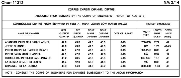
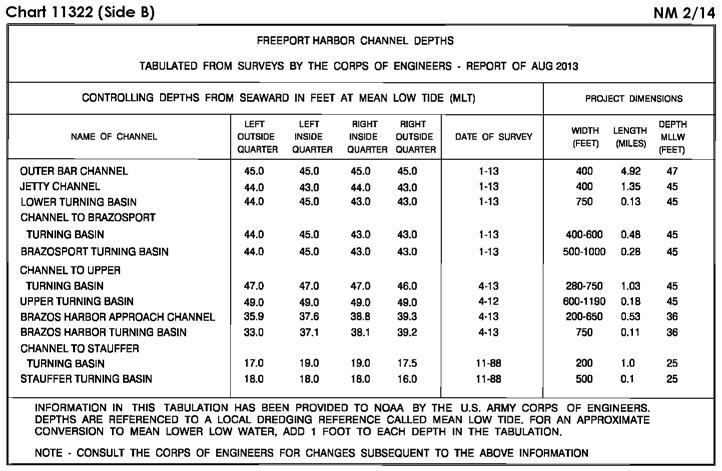
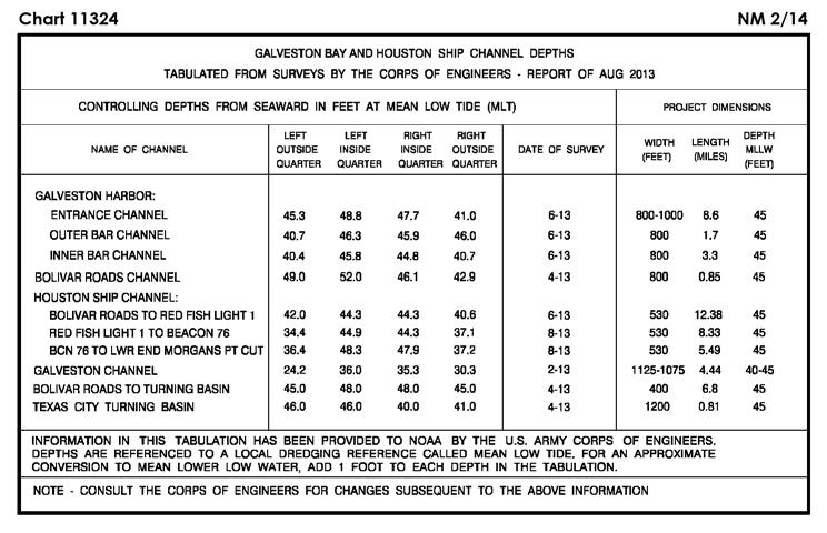
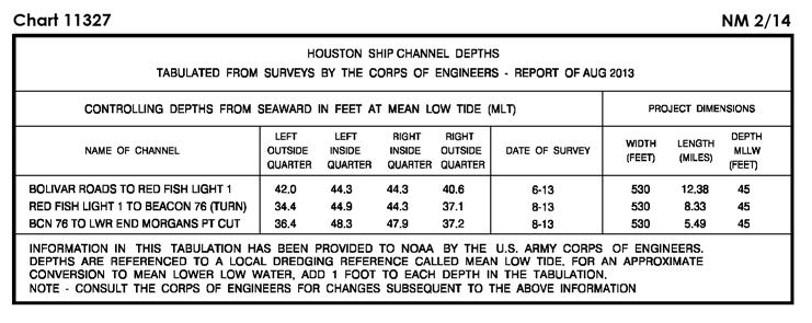
5 SECTION I NM CHART CORRECTIONS Ed. 5/08 LAST NM 49/13 Add Tabulation of controlling depths from Subsection I-2 (Supersedes 37/ ) (NOS) (NOS) Legend to BAYPORT SHIP CHANNEL 40 FT FOR WIDTH OF 300 FT JUL N W Legend to 42 FT AUG N W Ed. 9/11 LAST NM 49/13 (Side B) Add Tabulation of controlling depths from Subsection I-2 (Supersedes 37/ ) (NOS) Ed. 5/14/05 LAST NM N48/13 N Add Tabulation of controlling depths from Subsection I-2 (Supersedes N26/ ) (NOS) Ed. 4/12 LAST NM 52/13 Add Tabulation of controlling depths from Subsection I-2 (Supersedes 26/ ) (NOS) Ed. 5/14/05 LAST NM N52/13 N Add Tabulation of controlling depths from Subsection I-2 (Supersedes N26/ ) (NOS) Ed. 7/09 LAST NM 52/13 Add Tabulation of controlling depths from Subsection I-2 (Supersedes 26/ ) (NOS) Ed. 6/11 LAST NM 52/13 Add Tabulation of controlling depths from Subsection I-2 (Supersedes 1/ ) (NOS) Ed. 5/14/05 LAST NM N48/13 N Add Tabulation of controlling depths from Subsection I-2 (Supersedes N26/ ) (NOS) Ed. 5/12 LAST NM 37/12 (Side B) Add Tabulation of controlling depths from Subsection I-2 (See 37/ ) (NOS) Ed. 4/12 LAST NM 52/13 Add Tabulation of controlling depths from Subsection I-2 (Supersedes 26/ ) (NOS) Ed. 6/13 LAST NM 52/13 Add Tabulation of controlling depths from Subsection I-2 (NOS) Ed. 2/13 LAST NM 30/13 Add Tabulation of controlling depths from Subsection I-2 (Supersedes 26/ ) (NOS) Ed. 12/11 LAST NM 47/13 (Page A) Change Legend to 36 1 / 2 FT AUG N W Ed. 11/12 LAST NM 47/13 Change Legend to 36 1 / 2 FT AUG N W Legend to 40 FT FOR WIDTH OF 300 FT JUL N W Legend to 42 FT AUG N W (Supersedes 47/ ) Add Tabulation of controlling depths from Subsection I-2 (Supersedes 26/ ) (NOS) Ed. 1/13 LAST NM 35/13 Add Tabulation of controlling depths from Subsection I-2 (Supersedes 26/ ) (NOS) Ed. 5/08 LAST NM 35/13 Add Tabulation of controlling depths from Subsection I-2 (Supersedes 26/ ) (NOS) Ed. 10/12 LAST NM 37/13 Add Tabulation of controlling depths from Subsection I-2 (Supersedes 26/ ) (NOS) Ed. 4/07 LAST NM 37/13 Add Tabulation of controlling depths from Subsection I-2 (Supersedes 26/ ) (NOS) Ed. 5/13 LAST NM 47/13 Change Light to FY (Priv) N W (47/13 CG13) Ed. 10/11 LAST NM 47/13 (Page A) Change Light to FY (Priv) N W (Page B, Inset 1) Change Light to FY (Priv) N W (47/13 CG13) Ed. 2/11 LAST NM 2/13 Delete Light N W Add Light FY (Priv) N W (Inset) Delete Light N W Add Light FY (Priv) N W (47/13 CG13) Ed. 6/06 LAST NM 2/13 Add Height 16ft to light N W (47/13 CG13) Ed. 1/13 LAST NM 30/13 Add Height 16ft to light N W (47/13 CG13) I-1.1
6 NM SECTION I Ed. 6/12 LAST NM 49/13 Relocate Light 12 from N W to N W and change height to 24ft Change Height of light 33 to 26ft N W (47/13 CG13) Ed. 9/19/98 LAST NM 51/13 Change Platform to Lan Tay Mo(U) 15s Racon (T) N E Add Platform (lighted) [L10] N E Danger circle Wells [L20] N E Submarine pipeline (gas) [L40.1] between N E N E (8(129)13 Port Klang; 46(5159)12 Taunton; UKHO ARCS ) Ed. 8/18/12 LAST NM N1/14 N Substitute Dangerous wreck [K28] for stranded wreck N E (11(182)13 Port Klang) Ed. 5/8/04 LAST NM 52/13 Add Depth 7.2 meters Wk [K26] N E (Plan) Add Depth 7.2 meters Wk [K26] N E (11(181)13 Port Klang) Ed. 1/31/98 LAST NM 51/13 Add Stranded wreck [K24] (PA) N E (26T/13 Sabah; 8(130)13 Port Klang) Ed. 11/21/81 LAST NM 51/13 Add Stranded wreck [K24] (PA) N E (26T/13 Sabah; 8(130)13 Port Klang) Ed. 7/6/13 LAST NM N51/13 N Add Danger circle Well [L21.1] N E Danger circle Well [L21.1] N E Danger circle Well [L21.1] N E Danger circle Well [L21.1] N E Danger circle Well [L21.1] N E Platform (lighted) [L10] Platform (lighted) [L10] (49T/13 Sarawak; 8(128, 129)13 Port Klang) N E N E Ed. 1/22/11 LAST NM N13/13 N Add Buoy (mooring) [Q40] SBM N E Buoy (mooring) [Q40] SBM N E (8(129)13 Port Klang) Ed. 3/1/86 LAST NM 23/11 Add Stranded wreck [K24] (PA) N E (26T/13 Sabah; 8(130)13 Port Klang) I-1.2

7 SECTION I NM I-2.1


8 SECTION I NM I-2.2


9 SECTION I NM I-2.3

10 SECTION I NM I-2.4


11 SECTION I NM I-2.5


12 SECTION I NM I-2.6
13 SECTION I NM I-2.7
14 SECTION I NM CHARTS AFFECTED BY NOTICE TO MARINERS NM 1/13 THROUGH NM Note: N indicates Not For Sale; P indicates Preliminary; T indicates Temporary; * indicates New Edition/New Chart; ** indicates Chart Canceled Chart Ed. Notice to Mariners / / / ,34/ ,34/ ,43,45/ / ,18/ / / ,31/ / / / ,9,21/ / / ,34/ / / /13*;1/ / ,3,7,12,17,28,32,34,36, 42,45,48/ ,12,17,34,48/ ,31,41/ / / ,13,34,36,42/ / / / / ,51/ ,42/ ,51/ / / / ,11,17,28,32,34,36,38, 42,43,45,48,50,51/ ,36/ ,43,51/ / ,13,40/ / / / / ,35,46/ / / ,51/ A 21*,35,36,37,46/13;1/ A 37,46/ A 1,2,3,5,9,14,20,27,35,40, 42,47/ A 23*,25,27,30,32,33,35, 37,40,43,44,47,48,49, 52/ A 5,13,14,17,21,37,43,47, 52/ ,14,21,27,32,33,42,43, 47,52/ /13*;1/ ,8,40,44/ ,14,23,30,36,49/13;1/ N1,N5,N6/ ,13,14,17,21,37,43,47, 52/ ,26,37,40,43,47,49/13; ,26,37,49/13; N6,N13,N26,N48/13; N / ,52/ ,5,6,13,26,48,52/13; N1,N6,N26,N52/13; N ,13,33,49/ ,5,6,13,26,48,52/13; ,9/ ,52/ ,5,9,49,52/13; Chart Ed. Notice to Mariners ,5,21,49,52/ N6,N13,N26,N48/13; N ,49/ N5,N52/ ,33/ ,2,6,13,14,17,26,27,40, 47,52/13; *,52/13; *,26,30/13; ,2,14,33,35,37,47/13; *,26,47/13; *,26,33,35/13; ,26,33,35/13; *,35,44,48,49,52/ / *,21,25,26,27,37,49, 52/ *,26,27,33,43,47/ *,27,30,32,33,35,37, 40,43,44,47,48,49,52/ *,25,26,37,43,47,49, 52/ *,13,14,18,26,37/13; ,26,37/13; ,13,18,20,25,26,43,47, 49/ / ,20,26,32,37,40,42,49, 52/ *,27,33,43,44,47/ *,43/ ,3,4,6,9,13,15,18,27,35, 37,40,48,52/ ,5,13,48,49/ ,27,40,52/ ,27,49/ /13* *,37,40,44,47,49,52/ ,2,3,9,15,21,27,33,37, 40,42,43,44,47,49,52/ ,6,20,32,33,37,40,43,49, 52/ / ,2,3,5,9,14,20,27,35,40, 42,47/ *,40,42,44,49,52/ N1,N2,N3,N5,N9,N14, N20,N27,N35,N40,N42, N47/ *,20,27,30/ *,20,27,37,49,52/ ,3,5,9,14,20,27,30,32, 33,35,37,40,42,43,47,49, 52/ / / /13* / ,30,33/ ,14,20,27,30,33,37, 42/ /13* ,42/ /13* /13* /13* /13* /14* /13* ,49/ / /13* *,26,49/ ,46/ /13* /13* /13* /13* /13* *,32/ /13* /13* *,43,44/13 Chart I-3.1 Ed. Notice to Mariners *,35,36,37,46/13;1/ N51/13*;N1/ ,46/ *,32,46/ ,43/13;1/ ,43/13;1/ /13* / / /13*;1/ N51/13*;N1/ /13* *,36/ *,27,29,35,36,50/ *,16,35,36,50/13;1/ / *,27,29,35,36,50/ /13* / ,30/13;1/ ,5,8,11,16,30/13;1/ / / ,8,15,30/13;1/ ,14,30/13;1/ *,30/ *,30/ ,5/ ,11,16,30/13;1/ ,15,16,29/13;1/ ,15,16,17,44,46/ ,16/ / ,15,44,46/ N5,N15/ ,15,29,40,44/ N15,N17/ / ,37/ ,40/ N8,N28,N29,N47/ *,27,29,46,47/ N43/13* ,11,26,32,36,44/ *,46,47/ N5/ / ,11/ ,11,36/ ,6,8,17,26,29,32,35,36, 44,47,50/ ,29,32,51/ ,32,51/13;1/ / N8,N16,N49,N50/ N6,N8,N16,N35,N49/ N45/13* ,47/ *,35,49,50/ ,44,47/ ,11,16,26,27,32,35,36, 51/ ,11,16,27,29,35,51/ ,26/ ,26,32,36/ / *,32,35,36,51/ ,36/ ,11,16,27,35,51/ ,35,49/ ,17,51/ / ,22,35,43,46/ / ,17,22,35,46/ ,8,11,16,17,22,27,35,37, 49,51/ N35*,N47/ ,16,25/ *,6,8,27,35,36,49/ /13* ,51/ *,28,40,42/ *,32,47/ /13* *,32,47/ /13 Chart Ed. Notice to Mariners *,42,47/ ,21,24,28,32,42,47/ /13* ,7,8,11,17,23,24,31,34, 40/ N39*,N40/ *,17/ ,31,41,44,47/ *,22/ *,31,41,44/ *,47/ /13* *,34/ / ,17,20,27,44,46,47/ *,27,30,44,45,47/ ,27/ ,7,8,20/ ,20/ / *,39,46/ ,39/ ,11,27,44,46/ / / ,17,27/ ,17,27,32/ / /13* *,44/ /13* *,34,43,44/ / ,30,45,47/ ,45/ ,30,45/ *,27/ ,25,27,46/ *,27/ /13* /14* /13* ,9,12,27,43,46/ ,43/ ,27,43/ *,12,14,27,32,46/ ,7,9,11,12,20,27,39,44, 46,47/ ,14,32,42,44,46/ / *,26,39/ ,10,26/ ,10,26/ /14* ,8,11,12,14,21,23,24,25, 30,40/ N47/13* ,26,42/ ,9,14,25,34,42,43/ ,8,9,13,25,41,43/ ,9,13,42,43/ ,18,42/ / ,14,23,24,25,39,40/ *,12,14,23,34,40,42/ ,12,23,34,42,49/ *,35,49/ ,13,18,25,27,28,29,32, 35,39,41,48,49/ ,28,39,49/ *,49/ *,13,19,28,32,49/ ,25,27,28,32,41,49/ ,27,29,32/ *,32/ *,29/ /13* / /13* *,22,27,36/ /13* / / ,11,13,17,18,25,35, 45/ ,35/ /13
15 NM SECTION I CHARTS AFFECTED BY NOTICE TO MARINERS NM 1/13 THROUGH NM Note: N indicates Not For Sale; P indicates Preliminary; T indicates Temporary; * indicates New Edition/New Chart; ** indicates Chart Canceled Chart Ed. Notice to Mariners ,18/ ,4,13,18/ / /13* /13* / ,18/ *,45/ ,11/ / / ,48,49/ ,49/ ,8,11,14,16,17,23,24,25, 34,40,45/ ,8,11,14,16,20,32,45/ ,11,16,20,32,36,45/ ,45/ N44*,N45/ /13* ,18,21,25,30,36/ ,21,25/ / /13* ,36/ ,30,36/ /13* /13* / ,16,17,19,32,37,40, 49/ *,39/ *,33,49/ ,19,33/ /13* / /13* ,43/ ,43/ ,43/ /13* / ,43/ ,27/ / ,16,20,32,45/ N39*,N45/ /13* ,40,41/ ,25,28,35,40,49/ ,16,17,35,41,48/ ,11/ ,11/ *,48/ ,35/ / /13* /13* ,20,32/ /13* ,36/ / /13* / /13* ,36/ ,25,35/ ,35/ ,25/ /13* /13* /13* /13* /13* /13* *,17/ /13* ,23/ / ,42/ ,31,45/ / / ,31/ / / ,42/13 Chart Ed. Notice to Mariners / / / ,2,33,37/ ,33,42,43,45/ /13* ,2,35,37/ *,40,42,43/ *,15,33,40,42,43/ /13* /14* ,42,43/ / ,2,35/ /14* / / ,2,35/ ,35/ ,50/ / / ,35,45,50/ ,45/ ,33,42,47,51/ ,51/ ,48/ ,33,35,42,47/ *,45,47,48,50/ ,33,35,42,47/ ,35/ ,35/ ,50/ / ,20,29,34,40/ ,14,31,34/ *,29,34,37,40,43/ ,37,45/ /14* ,34/ / ,31,34/ / / ,51/ ,45/ ,45/ *,37,43,46/ / ,34,37,45,46,47/ ,47/ ,47/ ,46/ *,14,47/ / /13* ,30/ /13* ,34/ / ,33,43/ / / ,35/ / ,40/ ,47/ ,33/ ,40,44/ N33/ N33/ / ,21/ ,30,33,37,51/ ,33,37,43,51/ / / /13* ,21/ /13* /13* ,26/ / / / / /13 Chart I-3.2 Ed. Notice to Mariners / / / / ,51/ / / ,51/ / ,8/ *,8,40/ *,8,40/ / / / / / / / ,29,34/ ,34/ / ,34/ / / ,36/ ,27,36/ *,6/ /13* /13* /13* /13* / / / /13* /13* /13* /13* /13* / /13* /14* /14* /14* N4/ N4/ /13* /14* N4/ N2,N27,N36/ ,7,14,16,17,35,43,48/ N12*,N14,N16,N17, N20,N26,N35,N39,N41, N43,N48,N49,N50/ ,20,24,27,31,36,42, 45/ N12*,N17,N32,N34, N38,N40,N48,N50/ N13*,N48/ ,20,27,28,31,34,36,40, 42,45/ N2,N20,N28,N31,N34, N36,N42,N45/ N12*,N33,N34,N40, N50/ ,18,27,28,31,33,34,40, 42,50/ N14/ ,7,11,12,14,16,17,20,28, 32,34,35,38,39,40,41,48, 49,50/ ,7,11,12,14,16,17,20,26, 27,32,33,34,35,38,39,40, 41,43,48,49,50/ ,6,24,27,33/ *,33,40,41,47/13; ,20,24,26,27,30,32,33, 40,41,42,47/13; /13; *,33,47/ ,42/ ,33/ / / ,41/13 Chart Ed. Notice to Mariners ,20,27,30,32,38,40,42, 45,47,49/ ,27,30,32,38,42,46/ / ,24,25,30,38,40,42,45, 46,47,49/ ,38/ ,38,40,45,47,49/ ,24,25,30,40,46,47/ *,20,24,30,40/ /13* N2,N38/ / *,27/ N40/ / ,27,32/ / ,32/ / ,24,25,30,40,45,46, 47/ / *,27,47/ /13; *,27,30/13; ,20,24,32,33,42/ ,24,32,33,35,40/ / ,19,20,24,42,45/ ,6,20,31,32,35,36,40,42, 46,47/ ,26,31,35,42,46,47/ ,31,38,41,42,46,49/ ,4,18,20,31,38,40,46,47, 49/13; ,4,18,31,38,40,46,49/ / / ,18,19,20,31,45,46/ ,47/ / / ,46/ ,24,39/ / ,31,45/ ,32/ ,39,41/ ,8,10,19,32,35,45/ ,10,24,26,31,38,42/ ,26,33/ ,18,34/ / / ,19/ ,20,28,42/ ,27,42,43/ / *,33,40/13;1/ *,40/13;1/ / *,39,40,42,45,46, 48/13;1/ ,9,11,12,16,21,31,33,35, 39,40,42,46,48/13;1/ / ,5,9,11,12,16,17,21,27, 28,31,33,35,39,40,42,43, 45,46,48,49/13;1/ *,18,21,27,35,39,45/ / / ,28,35,49/ ,35,49/ ,35/ / ,43/ ,28,43/ / / ,35/ *,34,43,50/13;1/ ,43,50/ /14* *,27,32,38,45/13;1/ ,45/13
16 SECTION I NM CHARTS AFFECTED BY NOTICE TO MARINERS NM 1/13 THROUGH NM Note: N indicates Not For Sale; P indicates Preliminary; T indicates Temporary; * indicates New Edition/New Chart; ** indicates Chart Canceled Chart Ed. Notice to Mariners *,39,50/ ,14,17,22,30,31,40/ *,39,43/ *,39/ / ,50/ N3/ *,40,41,42,43,45,49, 50/ N13*,N16,N23,N27, N28,N41,N43/ *,40,41,42,43,49/ ,12,19,20,28,31,32,40, 42,50/ ,19,20,28,40,50/ ,43,49/13;1/ / / / N12*,N14,N16,N20, N26,N27,N28,N33,N35, N39,N41,N43,N49, N50/ N12/ ,12/ ,12/ ,11,12,16,23,28,43/ ,11,16,23,28,43/ N12*,N16,N23,N28, N43/ N13*,N27/ ,11,23,38,43/ ,9,11,23,38,43,49/ ,9,28,41/ N12/ N9,N14,N30,N37,N44, N49/ ,14,30,37,44,49/ ,14,37,44/ ,14,37,44/ ,14,30,49/ ,14,30,37,44,49/ ,41/ / ,41/ ,41/ N9,N14,N17,N19,N30, N40,N49/ ,14,17,19,30,40,49/ / / *,25,27,32,40/ ,5/ ,32/ / *,19,25,35,45/ *,19,25,45/ N44/ / / /13* N44/ ,7/ ,7/ N6/13* ,9,11,17,19,42,51/ ,42/ / / ,16,23,43/ / / N4/ / /13* / / / / ,5,6,7,8,15/ ,5,6,10/ ,9/ ,4,17,43/ ,17,42/ ,11,15,16,51/ ,11,12,19/13 Chart Ed. Notice to Mariners ,4,7,12,13,14,19,20,21, 24,36,37,47/ ,11/ ,4,7,11,12,13,14,19,20, 21,24,36,47/ ,8,11/ ,13,42,51/ ,42/ ,13,42/ / / ,7,8,15,30/ / N11*,N51/ N8/13* ,8,14/ / ,5,6,7,11,30/ ,6,7,34,35/ / / ,4,5,6,9/ ,9,31/ ,4,9,31/ ,6,33/ ,6/ ,10/ / / ,6/ N10/13* N7/13* / / / / / / / / / / / / ,18/ ,26/ N3,N30/ N44/13* / / / N9/ N4/13* N4/13* N9/ N9/ ,17/ / ,17/ / N51/13* ,27/ / / N6/ N6/ / / / ,4,17,43/ ,17,45,46/ ,5/ ,17,22/ ,21,24/ N3,N19/ / ,5,22,40/ ,9,25/ N1/14* N4/13* N5,N9,N48/ N8/13* N5,N9,N25/ N5,N9,N25/ N9,N25/ N30/13* ,12,48/13 Chart I-3.3 Ed. Notice to Mariners N5*,N48/ ,5,19,22/ N12*,N48/ / / / ,27/ N7*,N20,N26,N27,N47, N48/ ,24/ N5,N10,N11,N15,N16, N27,N40,N45/ N9,N11,N16/ N12*,N26,N27,N40, N45,N47/ N6,N8,N20,N26/ N14,N15,N26,N32,N43, N44/ ,20,24/ N16/ / / / / / N35/13* N11/13* / / N19/ / N8,N13,N31/ N8,N11,N13/ ,35/ ,35/ / / / N42/13* N42/13* N12/13* N6/ / / ,8/ / / / / / / / ,29,42,51/ ,21,42/ ,27,32,41,44,48,49, 52/ N7,N32,N49/ N7,N32,N49/ / ,44/ ,44/ ,44/ ,47/ ,8,37/ / / / ,18,37/ ,7,37/ / N11/13* / ,15/ ,15/ ,30,37/ / ,7,17,18,24,25,27,36, 42/ / / / ,30/ ,25,27,47/ ,36/ ,14,27,30/ ,8,33/ ,17/13 Chart Ed. Notice to Mariners ,8,33/ ,17,18,24,25,43/ ,4,8,10,17,20,24,25,43, 47/ ,4,5,10,20,25/ ,8,10,43,47/ ,3,4,5,8,10,20,25,43, 47/ ,24,43/ ,18/ / / ,25,27,47/ ,34/ / N17,N34,N46,N47,N48, N49/ ,34,46,48,49/ ,27/ / / / / ,19/ ,19/ / ,34,37/ / / ,36/ / ,34/ *,17,37,43,46,48,49/ /14* *,36/ / ,17,43,47,48,49/ / / / / ,49/ / / *,13,29,43,46/ ,51/ ,46,51/ ,43,46,48/ /14* *,46/ / / *,17,43/ / /14* ,46,48/ / / / / / ,15,36,42,43/ ,16,36,41,42/ / /13* / N46/ N32,N48/ N17,N48/ ,23/ ,15/ ,42,43/ / ,42,51/ / / / / N51/13* / N34/13* N11/ / / ,33/ ,3,15/ /13
17 NM SECTION I CHARTS AFFECTED BY NOTICE TO MARINERS NM 1/13 THROUGH NM Note: N indicates Not For Sale; P indicates Preliminary; T indicates Temporary; * indicates New Edition/New Chart; ** indicates Chart Canceled Chart Ed. Notice to Mariners / ,5/ / / ,15,30/ / /13;1/ / / / / / /13;1/ / ,31/ / / ,21/ / / ,31/ / / ,32/ / / ,17,48/ ,34/ / / / ,34/ /13;1/ ,32/ ,13,15/ / / / / / / / / / N31/13* / / / / ,40/ ,22/ / / / / / / / ,33/ N33/ N8/13* N35/13* N9/ N9/ N9,N21,N32/ N9,N21,N32/ N8/13* N11/13* N9/13* N34/13* N35/13* N11/13* N11/13* N25/13* N25/13* N10/13* N8/13* N27/13* N25/13* N25/13* N18/13* N17/13* N35/13* N8/13* N9/ N8/13* N9/13 Chart Ed. Notice to Mariners N9,N32/ N9,N21,N32/ N10/13* N21/ N21/ N17/13* N21/ N21,N32/ N21/ N9/13* N11/13* N24/13* N37/13* N34/13* N35/13* N10/13* N37/13* N40/13* N9/13* / N7*,N8,N31,N33, N41/ N34/13* N25*,N27/ N22/13* ,8,33,41/ N27/ N34/13* N25/13* N31/13* N27/13* N18/13* N8/13* N40/13* N10/13* N40/13* N33/ N37/13* N51/13* ,8,23,33,36,37,41,43/ N6,N21,N36,N41, N43/ / N51/13* N21,N41/ N44/13* N26*,N31,N33,N41, N43,N44,N48/ ,5,9,23/ / ,10,49/ ,6,8,9,10,11,12,13,44, 45,46,48,49,51/ N6,N8,N10,N11,N12, N21,N22,N45,N46, N49/ ,9,11,31,49/ N9*,N10,N22/ N25*,N44,N46/ N16*,N45/ N18/13* N16/13* N5,N8,N10,N11,N12, N13,N43,N44,N45, N49/ N8,N12,N44,N45,N50, N51/ N10,N13,N46,N49/ ,10,51/ N21,N22/ N45/13* N4/ N51/13* N6,N10,N21,N23,N27, N29,N30,N34,N49/ N1,N6,N13,N22,N29, N34,N44/ N9,N23,N33,N37,N43, N44,N49/ N36/13* N43/13* N42/13* N45/13* N43/13* N1/13* N15/13* N15/13* Chart I-3.4 Ed. Notice to Mariners N1/13* N6/13* N39/13* N9,N13/ ,13/ / / / / / N36/13* / / / / N43/ /13* N15/13* / / / N25/13* / N9/13* N45/13* N22/13* / / / / / / N36/ ,33/ / / N24/13* ,31/ / N5/ / N30/13* ,2/ / / ,11,33,35,42/ / N2/ N18*,N28/ N36/13* N8,N10/ ,44,50/ / ,45/ N12,N45/ N1,N8,N12,N43/ ,10,11,13,45,50/ ,11,13,41,45/ ,11,12,45,49/ N43,N50/ / / / / ,5/ / N51/13* / / / N25/13* N26/13* ,40,47/ ,38,39,42,47/ N27/13* ,38,39,40,42,47/ N1*,N42/ N8*,N39,N40,N42, N47/ N7,N39/ ,36,38,40,42/13;1/ N32,N37,N52/ N32/ N7/ N35/13* N6*,N19,N24,N31/ ,51/13;1/14 Chart Ed. Notice to Mariners ,35/ ,20,33,38,39,40,42, 47/ N5,N10,N20,N43,N47, N52/ ,39,42,47/ ,42,43/ ,11,20,35,42,43,48/ N5,N42,N43,N47/ N5,N6,N52/ N47/ N11,N20,N35,N48/ /13** N8,N11,N12,N13, N25/ N8,N9,N10/ N8/ / N41/13* N33/ N25,N33/ / N43/13* / / N1/13* / / / N25/13* N41/13* N38/13* / N4/13* N25/13* N39/13* / N34/13* N52/13* N21/ / N21/ N48/13* ,43,44/ / ,30/ / N30/13* N27/13* / / N30/13* N1/14* N18/13* N36/13* N51/13* N18/ N4/13* / N5/ / / / / N21/13*;N1/ / N1/ N1/ / N4/13* / / / / / N11/13* N52/13* N36/13* N7/13* N12/13* / ,48/ N37/ / / ,49/ ,49/13
18 SECTION I NM CHARTS AFFECTED BY NOTICE TO MARINERS NM 1/13 THROUGH NM Note: N indicates Not For Sale; P indicates Preliminary; T indicates Temporary; * indicates New Edition/New Chart; ** indicates Chart Canceled Chart Ed. Notice to Mariners ,43,45/ ,6,43,45/ ,45/ / / / / / / ,4/ N2/ / / ,5/ / / / / / / N11/13* / / N12/13* ,5,6,48/ ,6/ ,6/ / ,44,48/ N12*,N44/ N6/13* / / / / ,27,44,46/ ,41,42,47/ ,35/ N43/13* N15*,N29,N35,N39, N40,N42,N47/ ,40,42,43,52/ ,23,30,46,52/ / ,52/ / N1,N3,N6,N49/ ,3/ / N24/13* N52/ / / / ,24,27/ ,23,24,26,47,52/ ,26,46,52/ ,27/ N9,N23,N25,N28/ ,26,28/ ,4,8,49/ / / ,48/ N23,N28/ ,26/ ,23,25,26,30,44,47, 52/ ,44,52/ N25,N27/ ,25/ / ,43/ N4/ ,8,24,25,27,31,49/ ,27/ ,30,49/ ,23,24,25,27,31/ ,23,25,27,30,47,48, 52/ / ,7,44,47/ / / / ,45,46/ /13 Chart Ed. Notice to Mariners N5/13* N5/13* N5/13* ,8/ ,34/ / N8/ ,42/ / ,14,15,16,19/ ,17,19/ N26/13* N1/13* / ,13,14,15,16/ N13/ ,14,16,19,26/ N14/ ,19/ ,17/ ,15,16/ ,14,15,16,17,36/ N15,N19,N26,N33/ N11,N19,N26,N33/ N15,N19/ N15/ ,17,36,37/ / / / ,16,17,37/ ,17,19,36,49/ N16,N19,N26,N49/ N11,N14,N16,N17, N36/ N11,N14/ N14/ / N18/ ,36/ ,15/ N15,N36/ N26/ / / ,37,38/ / / N21/ N21/ / /13;1/ / / N22,N35/ / ,10,13/ ,45/ ,48,49/ ,11,12,15,16,18,21,46, 47,48,49,51/ N6,N11,N12,N15,N16, N18,N21,N46,N47,N48, N49,N51/ ,21,45/ N18*,N21/ N1/ N1/ / / ,49/ / / N41/13* / N26/13*;N1/ ,10,13/ N6*,N45/ / ,49/ / N7*,N45/ N26/13* / ,44/ / /13 Chart I-3.5 Ed. Notice to Mariners ,45/ / N6*,N17,N27,N28,N38, N43/ N41*,N43/ ,43,46/ ,28/ ,44,46/ / ,23,24,27,28,30,44, 46/ ,18,27,28,44,47,48, 49/ N11,N18,N27,N28,N44, N47,N48,N49/ ,49/ ,25,27,44/ ,16,41,49/ N42/ ,48/ N35/13* N1/13* / ,10,47,48/ / / / / ,44,47/ N21*,N47/ / ,10,15,16,21,47/ ,11,20,22,31,34/ ,11,15,34/ / N1/13* /13;1/ ,11,12,14/13;1/ / / / N27/13* ,16/ ,10,15,21,46,47,52/13; 1/ / N35/13* N12/13* N21/ N31/13* N8,N15,N34/ N5/13* ,22/ /13;1/ ,47,48/13;1/ N5/13* N6/13* N20/ ,8,11,12,15,16,18,21,42, 46,47,48,49,51/13;1/ ,11,12,20,21,42,46/ N6,N45,N47/ N20,N45/ ,10,11,18,47,48/13;1/ N6,N10,N11,N18,N47, N48/13;N1/ ,10,15,16,21,46,47,48, 51/13;1/ N6,N10,N15,N16,N21, N46,N47,N48,N51/13; N1/ ,8,11,12,14,21,22,42, 46/ N6,N8,N11,N12,N14, N21,N42,N46/ ,18,20,21,23,24/ N15,N18,N20,N21,N23, N24/ ,8,11,21,22,46,48,51/ / ,21/ ,17,23/ ,16,17,20/ N11,N17,N20/ / ,27,34,37,48/ ,27,28,34,37/13 Chart Ed. Notice to Mariners ,22,29,30,35,40,46/ ,28/ ,45/ ,48,49/ ,49/ / ,21/ ,22,23,34,37,48,49/ ,27,34,37/ / ,37/ ,27,37/ ,34,35,37,45/ ,27,31,35,44,45/ ,27,28,34,37,45/ N24*,N37/ / N9,N22,N27,N31,N35, N44,N45/ N22,N27,N31/ N22,N31/ / N27/ N27/ ,44/ ,28/ ,27,28,29,34,35,37, 46/ ,34/ N28,N44/ N28,N34/ ,34/ / ,40/ N40/ / ,23/ N23/ ,22,27,44/ / ,28,34/ N23,N28/ N35/ / ,45/ ,47/ ,47/ ,42/ / N6*,N35/ / /13;1/ ,42/ N27,N42/ N42/ ,33,42/ ,38,51/13;1/ / / N26/13* ,16,29,30,31,38,39,43, 44,45,46,51/13; / ,37/ N22/ / / / N39/13;N1,N N28,N32/ N28,N29,N32/ N29,N32,N42/ /13; N34/13* ,6/ N26/13* N29/ N29/13;N1/ N4/ N31/13* N4,N6,N29,N48/ / ,6,16,29,40,48/ N6/ N6/ ,38,40,51/ /13
19 NM SECTION I CHARTS AFFECTED BY NOTICE TO MARINERS NM 1/13 THROUGH NM Note: N indicates Not For Sale; P indicates Preliminary; T indicates Temporary; * indicates New Edition/New Chart; ** indicates Chart Canceled Chart Ed. Notice to Mariners / ,42,51/13;1/ / /13; /13; ,51/13;1/ N45/13* N7/13* N42/ ,43,49,51,52/ ,49/ N43*,N44,N51/13;N N13/13;N ,45/ N45/13* ,45/ N51/ / / ,29,40,46,48,52/ / / / / / / / ,52/ / N15/13* / / / / / / / / ,7,9,11/ ,28/ ,4,13/ ,50/ / N51/ N23/13* / N24/13* N5,N6,N8,N9,N11, N38/ N11/ N8,N9,N11,N47/ N8,N9,N11/ / / N4,N51/ ,9/ ,48/ / N49/ ,49/ N47,N49/ N44/ N14/ / N47/ N50/ N49/ / N14/ ,43/ N43,N47/ N44/ N50/ N26/13* N44,N50/ N44,N50/ / N14,N51/ N14,N15/ N15/ ,15/ N26/13* / / / / N35/13 Chart Ed. Notice to Mariners N2,N3,N4,N43,N51/13; N1/ N25*,N35,N49/ N2,N3,N4,N14,N44/ N51/ N49/ / N10,N11,N13/ N4,N13/ N13/ N2,N3,N4,N14,N44, N49,N51/13;N1/ N2,N3,N4,N14,N49/13; N1/ ,4,50/13;1/ / / N3/ / / / N4,N20/ N20/ ,7,8,9,11/ / / N3/ N25/13* N24/13* / ,9,11,13/ N3/ N5,N8,N9,N11,N13/ N5,N6,N8,N9,N11,N14, N38,N39/ N14,N38,N39,N50/ N14,N38,N43/ N5,N6,N7,N8,N9,N11, N38,N39/ ,14,15/ / N26/13* / / ,15/ / / / / / / / / ,33/ ,28/ ,31/ ,41/ / / / N32,N41/ / / / *,18,44/ /13* /13* /13* /13* /13* / / / / / / N12/13* / / ,6,13/ ,11,33,44,52/ ,52/ / ,52/ ,8/ N51/13* /13 Chart I-3.6 Ed. Notice to Mariners / N34/13* / / N3,N4,N5,N8,N52/ N5,N8,N52/ ,8,52/ N43/13* N34/13* N35/13* ,5,14/ ,14/ ,29,35/ / ,14/ / / N10/13* / / N1/14* ,29,35/ / / ,18,28,33,35,36,39,44, 46,51/ ,29,37,40,41,43,44, 52/13;1/ ,37,40,41,43,44,52/13; 1/ ,12,14,24,30,46,50/13; 1/ / ,9,10/ ,21,46,50/ ,9,12,18,37,39,40/ N24*,N25,N28,N33, N36,N37,N39,N40,N46, N51/ / / / / ,42,49/ ,46,50/13;1/ ,44,46,52/ ,40,46,52/13;1/ N40,N44/ N39,N40/ / ,43,44/ N22,N37/ N45/13* / N10*,N22/ ,37/ N22,N47/ / / ,40,47/ ,41/ / N12/13* / N8/13* N22/13* N24/13* N8/13* N12/ N34/13* N6/13* ,12,18,37,39,40/ ,37,40/ ,9,10/ N9/ ,9/ N8,N9,N10/ ,9,10/ N31/13* N8,N9/ ,18,28,29,46/ N6,N9,N13,N27,N28, N29,N30,N32,N33,N38, N40,N44,N46,N48, N51/ ,33,42/13 Chart Ed. Notice to Mariners N6*,N9,N13,N18,N28, N29,N33,N35,N36,N39, N42,N44,N46,N48/ N5,N9,N13,N18,N26, N28,N42,N46,N48/ N13,N18,N26,N28,N46, N48/ N5,N26,N27/ N35/13* ,30,33,52/ ,12,30,31,36/ ,14,16,25,28,32,34,35, 42/ ,16,19,20,23,40,42/ / N1*,N43/ ,30,33/ ,13/ / ,46/ ,52/ ,30,32,33,35,43/ N35/13* N36*,N43/ ,11,31,40/ N33,N37,N40/ N28/ N28/ ,9,11,25,28,43,45/ ,14,25,26/ ,14,36/ ,35,36,42/ N41/ ,34/ / ,9,10,12,13,14,15,16,17, 34,35,36,39,41,45,52/ ,9,10,11,16,34,39,45/ N35,N52/ N35,N52/ N8,N46/ N8,N33/ N8,N46/ ,10/ N1*,N16,N36/ N1/13* N15/ ,8,12,13,36/ N7,N8,N10,N11,N12, N13/ / / N15,N20,N37/ N15,N20,N37,N44, N45/ N15,N19,N44,N45/ N11/13* ,37,39,40,42/ ,39/ N17,N19/ N18/ N16,N42/ N17*,N19,N23,N27, N34/ N23,N25,N30,N34/ N19,N20,N21,N22,N23, N24,N25,N26,N27,N29, N30,N31,N33,N34/ N22,N23,N24,N28,N29, N30/ N6*,N19,N20,N21,N22, N26,N28,N32,N33/ N11/13* N30/ N26,N27,N30,N31/ N26,N27,N31/ ,28,32,34/ N28,N34/ N27/ N32,N34/ N22/ N23,N28/ N28/ ,25,32,35/ N25/ N22,N25,N28/ /13
20 SECTION I NM CHARTS AFFECTED BY NOTICE TO MARINERS NM 1/13 THROUGH NM Note: N indicates Not For Sale; P indicates Preliminary; T indicates Temporary; * indicates New Edition/New Chart; ** indicates Chart Canceled Chart Ed. Notice to Mariners / N1/13* ,25,28,33,48/ N23,N25,N27,N28,N31, N32,N34,N37/ N32,N33,N48/ N28/ N32,N33,N48/ N29/ N45/13* N27/ N27/ N29,N33,N48/ N17/13* N10,N11/ N5/13** /13** N5/13* N1/13* / ,8/ ,21/ N1*,N35/ ,35,38/ / ,51/ / / / / / N42/13* / ,11/ ,25,28,35/ N21,N22,N32,N35/ / N16/13* N37/13* N1/13* N16/13* N36/13* /13** N30/13* / /13** N30/13* N37/13* /13** /13** /13** N27/13* /13** N40/13* / N42/13* N40/13* /13** / /13** ,28/ N16/ / / ,28,31/ N10/13* ,11/ N12/13* ,31/ / / N13/13** N12/ N21/13** N25/13** N25/13* N16,N48/ N46/ N4/ N12/ N5/ N48/13* N19,N20,N21,N22,N23, N24,N25,N27,N29,N30, N31,N33,N34/ N39/13** N20/13* Chart Ed. Notice to Mariners N23,N28/ N41/ N29/ N19,N20,N23,N24,N25, N27,N30,N31/ N49/13* N5/13* N40/13* N40/13* N25/13* N35/ N22,N23,N24,N27,N29, N30/ N11/ N5/ N25/13** N33,N34/ N19,N32/ N28,N32,N33,N48/ N11/ N49/ N25,N28,N32/ N25*,N52/ N29/ N27/ N33,N34/ N17*,N19,N20,N21, N26,N28,N32,N33/ N25/13* N13*,N23,N43/ N17,N48,N49/ N25/13** N39/13* N40*,N48/ N23,N25,N27,N28,N31, N32,N34,N37/ N17/13* N21*,N25,N40,N49/ N13/13* N25/13* N25/13* N38/13* N13/13** N38/13** I-3.7
21 SECTION II NM NGA/DLIS CATALOG CORRECTIONS Note: Underlining indicates that column in which a correction has been made or new information added. Edition NGA Ref. (National Stk. ) Title Scale = 1: Date Price Category NTM MISCELLANEOUS CHARTS AND PUBLICATIONS DNCDX026 ( ) British Columbia 28 11/13 DS Price Categories effective 1 October 2013 A D E F G 7.25 H CHS Canadian Hydrographic Service DS Distribution Limited GPO Government Printing Office NOS National Ocean Service UKHO United Kingdom Hydrographic Office DHO Danish Hydrographic Office AHS Australian Hydrographic Service JCG Japan Coast Guard * Not for sale or reproduction outside U.S.A. To locate the nearest FAA Sales Agents in your area, go to: Note: New editions cancel former editions. They include corrections published in the Notice to Mariners prior to the effective date of the new editions and/or important corrections from other sources. Mariners are warned against the use of obsolete charts and publications as new editions contain information essential to safe navigation; however, such new editions are not valid until their availability is announced in the weekly Notice to Mariners. DoD users and DoD contractors may direct questions concerning the availability and distribution of announced hardcopy charts to the Defense Logistics Agency (DLA) at or ; DSN ; Fax Civilian users can obtain information about ordering NGA paper charts at: II-1.1
22 SECTION II NM NAVIGATION PUBLICATIONS COAST PILOT CORRECTIONS COAST PILOT 2 43 Ed DEC 2013 LAST NM 52/13 Chapter 9 Paragraph 307; read: (307) Hutchinson River empties into the north end of Eastchester Bay. A dredged channel marked by buoys leads from the river mouth for about 2.5 miles to the head of navigation at the city of Pelham. (L ; DD 23813; LNM 48/13 CG1) COAST PILOT 4 45 Ed DEC 2013 LAST NM 47/13 Chapter 4 Paragraphs 178 to 179; read: (178) Scuppernong River empties into the eastern end of Bull Bay from southeastward. Lights and daybeacons mark the channel from the bay to Columbia. A marina on the south side of the river, 3 miles above the mouth, has berths with electricity, gasoline, diesel fuel, pump-out station, water, ice, some marine supplies, wet and dry storage, and a launching ramp. A 25-ton mobile lift is available; hull and engine repairs can be made. In 2013, the reported approach depth was 6 feet. (179) Columbia, a small town 4 miles above the mouth of the river, has two inactive oil docks and several landings. The landings have depths of 14 to 16 feet alongside, but are in poor condition and not able to accommodate more than one boat at a time. A marina, on the east side of the river has gasoline, diesel fuel, berthing and water. In 2013, the reported alongside depth was 8 feet. (DB small) COAST PILOT 7 46 Ed DEC 2013 LAST NM 1/14 Chapter 7 Paragraphs 293 to 294; read: (293) S of San Francisco, Point Avisadero, which is the E extremity of Hunters Point, Sierra Point, Oyster Point, Point San Bruno, and Coyote Point, all on the W shore of the bay, are prominent natural features. The Bayshore Freeway extends S on a filled area from the vicinity of Candlestick Point, and cuts back inland at Sierra Point. Sierra Point is the site of a small-boat harbor which can accommodate about 500 boats. Oyster Point Channel is marked by private lights and leads to a small basin. A spur channel, marked by private lights, branches off the N side of Oyster Point Channel and leads to the entrance to the smallboat harbor at Sierra Point. The basin at the end of Oyster Point Channel has two private wharves in ruins and sheds on the W side; a marina that can accommodate about 200 boats is on the S side. (294) Oyster Point, a low filled area, is the site of a smallboat harbor accommodating about 570 boats. An entrance channel E of the harbor is marked by private lights. Transients should report to the harbormaster s office for berth assignment. A prominent sculptured tower is on the hill 0.7 mile S of Oyster Point; the tower is floodlighted. (NOS 18561) Chapter 14 Paragraph 992; read: (992) Between Waimea River and Oomano Point, 2.3 miles to the W, a reef extends 0.4 mile from shore and breaks in heavy weather. Kikiaola Boat Harbor, 1.6 miles W of the river, is entered over the reef and is protected by breakwaters. The end of the west breakwater is marked by a privately maintained light. The harbor has a launching ramp and loading piers; the entrance is marked by a privately maintained lighted range. Caution should be exercised when entering or leaving the harbor due to the combined effects of the breakers and the 90 turn in the basin. (DD 23849) II-2.1
23 SECTION II CORRECTIONS TO C. G. LIGHT LIST, VOLUME I ATLANTIC COAST, 2013 (1) (2) Name and Location (3) Position (4) Characteristic (5) Height (6) Range (7) Structure (8) Remarks *10973 CHELSEA STREET BRIDGE NORTH SIDE BULKHEAD LIGHT * CHELSEA STREET BRIDGE SOUTH SIDE BULKHEAD LIGHT N W N W BRANFORD REEF LIGHT N W UPPER DIRECTIONAL LIGHT MIDDLE RANGE FRONT LIGHT N W N W STRAITS HILL LIGHT N W LIGHT N W LIGHT N W Q Y Q Y Fl W 6s 30 7 NR on skeleton tower. Private aid. Private aid. F W (G & R sector) 21 W 7 R 5 G 5 On pile. Shows green from to ; white from to ; red from to ; with a F W passing light. Q G 15 3 On pile. Visible all around; higher intensity on range line. Lighted throughout 24 hours. Q W 23 7 NR on skeleton tower. Higher intensity beam up river. Fl R 2.5s 30 3 TR on skeleton tower. Fl G 4s 30 3 SG on skeleton tower Buoy N W Green can Buoy N W Red nun. CORRECTIONS TO C. G. LIGHT LIST, VOLUME II ATLANTIC COAST, 2013 (1) (2) Name and Location (3) Position (4) Characteristic (5) Height (6) Range (7) Structure (8) Remarks Daybeacon 1 Remove from list Daybeacon N W TR on pile. Private aid. Note: Asterisks (*) indicate that column(s) in which a correction has been made or new information added. Denotes a new entry when preceding the station number. II Daybeacon N W SG on pile. Private aid Daybeacon N W SG on pile. Private aid Daybeacon N W SG on pile. Private aid JUNCTION LIGHT AR N W Fl (2+1) G 6s 15 5 JG on pile.
24 SECTION II CORRECTIONS TO C. G. LIGHT LIST, VOLUME II ATLANTIC COAST, 2013 (1) (2) Name and Location (3) Position (4) Characteristic (5) Height (6) Range (7) Structure (8) Remarks CHANNEL LIGHT N W CHANNEL LIGHT N W LIGHT N W Fl R 4s 15 5 TR on pile. Fl R 4s 15 4 TR on pile. * Fl R 2.5s 15 4 TR on pile. * * * LIGHT N W Fl R 4s 15 4 TR on pile. * * * LIGHT N W Fl R 2.5s 15 4 TR on pile. * * * Lighted Buoy N W Lighted Buoy 1SF N W Hatteras South Ferry Junction Lighted Buoy HS Buoy 2SF N W Q R 5 Red. Replaced by nun when endangered by ice. Fl G 2.5s 4 Green. Red nun. Remove from list Lighted Buoy 3SF N W Fl G 2.5s 4 Green LIGHT N W Fl G 4s 15 4 SG on pile LIGHT N W Fl G 2.5s 17 4 SG on pile Channel Lighted Buoy N W Fl G 4s 5 Green ROYAL SHOAL LIGHT 5RS N W Outer Shoal Daybeacon OS N W Buoy 160A N W Q G 40 5 SG on multi-pile structure. NB on pile. Red nun with yellow triangle. Maintained from Nov. 1 to May 1. Removed when endangered by ice. * Note: Asterisks (*) indicate that column(s) in which a correction has been made or new information added. Denotes a new entry when preceding the station number. II-3.2
25 SECTION II CORRECTIONS TO C. G. LIGHT LIST, VOLUME III ATLANTIC AND GULF COAST, 2013 (1) (2) Name and Location (3) Position (4) Characteristic (5) Height (6) Range (7) Structure (8) Remarks Lighted Buoy N W Terminal Lighted Buoy N W FRONT LIGHT N W REAR LIGHT 906 yards, from front light LOWER RANGE REAR LIGHT 899 yards, from front light N W Fl G 4s 5 Green. Fl R 6s 5 Red. Q W 46 KRW on square skeleton tower on piles. Note: Asterisks (*) indicate that column(s) in which a correction has been made or new information added. Denotes a new entry when preceding the station number. II-3.3 Visible 2 each side of rangeline. * Iso W 6s 65 KRW on square skeleton tower. Visible 2 each side of range line N W Iso G 6s 59 KRW on skeleton tower on piles. Visible 1.5 each side of rangeline. * * LIGHT N W Lighted Buoy N W *10351 SFOMF Restricted Area Lighted Buoy A * SFOMF Restricted Area Lighted Buoy B * SFOMF Restricted Area Lighted Buoy C * SFOMF Restricted Area Lighted Buoy D * SFOMF Restricted Area Lighted Buoy E * SFOMF Restricted Area Lighted Buoy F * SFOMF Restricted Area Lighted Buoy G * SFOMF Restricted Area Lighted Buoy H N W N W N W N W N W N W N W N W LIGHT N W Fl G 4s 16 5 SG on pile. Fl G 2.5s 5 Green. Fl (2) W 12s Fl (2) W 6s Fl (3) W 10s Fl W 2s Fl W 4s Fl W 6s Iso W 4s Fl W 9s White can with orange bands. White can with orange bands. White can with orange bands. White can with orange bands. White can with orange bands. White can with orange bands. White can with orange bands. White can with orange bands. Fl G 2.5s SG on pile. Private aid. Maintained by US Navy. Private aid. Maintained by US Navy. Private aid. Maintained by US Navy. Private aid. Maintained by US Navy. Private aid. Maintained by US Navy. Private aid. Maintained by US Navy. Private aid. Maintained by US Navy. Private aid. Maintained by US Navy. Private aid. * LIGHT N W ENTRANCE RANGE FRONT LIGHT Fl R 4s TR on pile. Private aid. * N W Q G 48 KRW on skeleton tower. *
26 SECTION II CORRECTIONS TO C. G. LIGHT LIST, VOLUME III ATLANTIC AND GULF COAST, 2013 (1) (2) Name and Location (3) Position (4) Characteristic (5) Height (6) Range (7) Structure (8) Remarks ENTRANCE RANGE REAR LIGHT 721 yards, from front light N W Iso G 6s 90 KRW on skeleton tower LIGHT N W East Featherbed Obstruction Daybeacon A * East Featherbed North Obstruction Daybeacon * East Featherbed Northwest Obstruction Daybeacon * East Featherbed West Obstruction Daybeacon * East Featherbed Southwest Obstruction Daybeacon East Featherbed Northeast Obstruction Daybeacon * East Featherbed Southeast Obstruction Daybeacon * East Featherbed NNE Obstruction Daybeacon * Middle Featherbed Southwest Obstruction Daybeacon * Middle Featherbed Northeast Obstruction Daybeacon * Middle Featherbed NNE Obstruction Daybeacon WEST FEATHERBED NORTH OBSTRUCTION LIGHT WEST FEATHERBED SOUTH OBSTRUCTION LIGHT * West Featherbed Southwest Obstruction Daybeacon * West Featherbed Northwest Obstruction Daybeacon *49731 Lewis Cut Obstruction Daybeacon N W * Fl G 4s 12 5 SG-SY on dolphin. NW on pile worded OBSTRUCTION. Private aid N W N W N W N W N W NW on pile worded OBSTRUCTION. NW on pile worded OBSTRUCTION. NW on pile worded OBSTRUCTION. NW on pile worded OBSTRUCTION. NW on pile worded OBSTRUCTION. Private aid. Private aid. Private aid. Private aid. Private aid. * N W N W N W N W N W N W NW on pile worded OBSTRUCTION. NW on pile worded OBSTRUCTION. NW on pile worded OBSTRUCTION. NW on pile worded OBSTRUCTION. NW on pile worded OBSTRUCTION. Fl R 2.5s 12 NW on pile worded OBSTRUCTION. Private aid. Private aid. Private aid. Private aid. Private aid. Private aid. * * N W Fl W 4s 14 NW on pile worded OBSTRUCTION. Private aid. * N W N W N W NW on pile worded OBSTRUCTION. NW on pile worded OBSTRUCTION. NW on pile worded OBSTRUCTION. Private aid. Private aid. Private aid. Note: Asterisks (*) indicate that column(s) in which a correction has been made or new information added. Denotes a new entry when preceding the station number. II-3.4
27 SECTION II CORRECTIONS TO C. G. LIGHT LIST, VOLUME III ATLANTIC AND GULF COAST, 2013 (1) (2) Name and Location (3) Position (4) Characteristic (5) Height (6) Range (7) Structure (8) Remarks Buoy 38A N W Red nun with yellow triangle LIGHT N W Fl G 4s 16 5 SG-SY on pile. CORRECTIONS TO C. G. LIGHT LIST, VOLUME IV GULF OF MEXICO, 2013 (1) (2) Name and Location (3) Position (4) Characteristic (5) Height (6) Range (7) Structure (8) Remarks *882 Tana Lighted Buoy N W 7143 ALGAE SYSTEMS AQUACULTURE SPECIAL LIGHTS (13) N W Fl W 2.5s Fl Y 2.5s White with orange bands. Marks aquaculture dock. SIGN: TANA-VE Private aid. Private aid. * LIGHT N W Fl R 2.5s 17 3 TR on pile. Ra ref. * * * LIGHT N W Fl R 6s 17 3 TR on pile. Ra ref. * * * LIGHT N W Fl (2) R 5s 17 3 TR on pile. Ra ref. * * * * Buoy N W Green can. CORRECTIONS TO C. G. LIGHT LIST, VOLUME VI PACIFIC COAST AND PACIFIC ISLANDS, 2013 (1) (2) Name and Location (3) Position (4) Characteristic (5) Height (6) Range (7) Structure (8) Remarks 196 NOAA Environmental Lighted Buoy NOAA Environmental Lighted Buoy PORT ORFORD JETTY LIGHT N W N W 1250 CAPE SENIAVIN LIGHT N W PANCAKE POINT DIKE LIGHT FISHER QUARRY CHANNEL RANGE REAR LIGHT 272 yards, from front light N W N W Fl (4) Y 20s Yellow 3-meter diskshaped buoy. Aid maintained by NOAA. * Fl (4) Y 20s Yellow 3-meter discshaped buoy. Aid maintained by NOAA. Fl W 6s NR on skeleton tower. Remove from list. Fl G 6s 24 4 SG on multi-pile structure. * Iso G 6s 59 KRB on skeleton tower. Visible 5.5 each side of range line. Note: Asterisks (*) indicate that column(s) in which a correction has been made or new information added. Denotes a new entry when preceding the station number. II-3.5
28 SECTION II CORRECTIONS TO C. G. LIGHT LIST, VOLUME VI PACIFIC COAST AND PACIFIC ISLANDS, 2013 (1) (2) Name and Location (3) Position (4) Characteristic (5) Height (6) Range (7) Structure (8) Remarks Daybeacon N W Daybeacon N W Daybeacon N W Daybeacon N W Daybeacon N W TR on pile. * TR on pile. * TR on pile. * TR on pile. * * TR on pile. * Point Wells Fog Signal Remove from list Yuzhni Point Buoy N W Red nun NORTH ENTRANCE LIGHT N W Fl G 2.5s 4 SG on spindle. * * * * ANDRONICA ISLAND LIGHT N W Fl W 4s On square frame. Obscured from 275 to and from 317 to 078. CORRECTIONS TO C. G. LIGHT LIST, VOLUME VII GREAT LAKES, 2013 (1) (2) Name and Location (3) Position (4) Characteristic (5) Height (6) Range (7) Structure (8) Remarks LIGHT N W LIGHT N W LIGHT N W LIGHT N W Fl R 2.5s Iso G 6s Iso R 6s Iso G 6s White cylindrical tower with red band. 3 White cylindrical tower with green band. 4 White cylindrical tower with red band. * 3 White cylindrical tower with green band. Note: Asterisks (*) indicate that column(s) in which a correction has been made or new information added. Denotes a new entry when preceding the station number. II-3.6
29 SECTION II NM PUBLICATIONS AFFECTED BY NOTICE TO MARINERS THROUGH NM Note: * indicates New Edition/New Publication; ** indicates Publication Canceled; N indicates Not For Sale Publication Ed. Notice to Mariners Publication Ed. Notice to Mariners Publication Ed. Notice to Mariners NGA/DLIS CATALOGS CATCDLIMDIS Region *,47,48,51,52/13; 1/14 Region *,51,52/13;1/14 Region *,51/13 Region *,51/13 Region *,48,51,52/13; 1/14 Region /13* Region /13* Region /13* Region *,51/13;1/14 Miscellaneous Charts and Publications *,47,48,49,51, 52/13;1, NGA LIST OF LIGHTS PUB *,21,22,23,24,25, 27,30,31,32,33,36, 37,39,40,41,42,43, 44,46,51/13 PUB *,34,35,39,41,43, 44,50,51/13 PUB *,47,51,52/13; 1/14 PUB *,44,49,51,52/13; 1/14 PUB *,32,34,44,46,49, 50/13 PUB *,39/13;1/14 PUB *,37,38,39,42,47, 49,50,52/13;1/14 SAILING DIRECTIONS PUB /13* PUB /13* PUB /13* PUB /13* PUB /13* PUB /13* PUB /11* PUB /11* PUB /13* PUB /13* PUB /13* PUB /11* PUB /13* PUB /13* PUB /13* PUB /13* PUB /13* PUB /13* PUB /13* PUB /13* PUB /12* PUB /11* PUB /13* PUB /13* PUB /11* PUB /11* PUB /11* PUB /13* PUB /12* PUB /13* PUB /13* PUB /10* PUB /13* PUB /10* PUB /13* PUB /13* PUB /13* PUB /13* PUB /13* PUB /13* PUB /13* PUB /11* USCG LIGHT LIST VOLUMES I - VII VOLUME I *,22,23,24,25,26, 27,28,29,30,31,32, 33,34,35,36,37,38, 39,40,41,42,43,44, 45,47,48,49,50,51, 52/13;1, VOLUME II *,21,22,23,24,25, 26,27,28,29,30,31, 32,33,34,35,36,37, 38,39,40,41,42,43, 44,45,46,47,48,49, 50,51,52/13;1, VOLUME III *,23,24,25,26,27, 28,29,30,31,32,33, 34,35,36,37,38,39, 40,41,42,43,44,45, 46,47,48,49,50,51, 52/13;1, VOLUME IV *,23,24,25,26,27, 28,29,30,31,32,33, 34,35,36,37,38,39, 40,41,42,43,44,45, 46,47,48,49,50, 52/13;1, VOLUME V /12* VOLUME VI *,20,21,22,23,24, 25,26,27,28,29,30, 31,32,33,34,35,36, 37,38,39,40,41,42, 43,44,45,46,47,48, 49,50,51,52/13;1, VOLUME VII *,21,22,23,26,27, 28,29,30,31,32,33, 34,35,36,39,42,43, 45,46,47,49,51/13;1, DIGITAL PUBS - QUARTERLY DIGITAL PUBS - QUARTERLY 2013 N42/13* FLEET GUIDES PUB N1/14* PUB N1/14* NOS MISCELLANEOUS PUBLICATIONS CATALOG A /12* CATALOG G /12* CATALOG K /12* CATALOG L /12* CATALOG P /12* ALMANACS AIR ALMANAC /13* NAUTICAL ALMANAC /13* COAST PILOT COAST PILOT *,27,28,31,37,47, 52/13 COAST PILOT *,41,47,52/13; COAST PILOT /13* COAST PILOT *,40,47/13; COAST PILOT *,21,23,27,29,31, 32,33,37,41,42, 47/13 COAST PILOT *,11,12,13,14,16, 19,20,27,31,32,33, 35,36,37,39,45,47, 48,51/13;1/14 COAST PILOT *,51,52/13;1, COAST PILOT *,31,37,47,51/13 COAST PILOT *,37,40,41,42,46, 47,48,49,52/13 RADIO NAVIGATIONAL AIDS PUB /05*;9,25/12 AMERICAN PRACTICAL NAVIGATOR PUB /02*;14,38/03; 40/05 INTERNATIONAL CODE OF SIGNALS PUB /03* WORLD PORT INDEX PUB /13* DISTANCES BETWEEN PORTS PUB /02* RADAR NAVIGATION AND MANEUVERING BOARD MANUAL PUB /01* SIGHT REDUCTION TABLES (MARINE) PUB 229 VOL /71* PUB 229 VOL /71* PUB 229 VOL /71* PUB 229 VOL /71* PUB 229 VOL /71* PUB 229 VOL /70* SIGHT REDUCTION TABLES (AIR) PUB 249 VOL /07* PUB 249 VOL /52* PUB 249 VOL /52* CHART NO. 1 CHART NO /13* CHART NO. 4 CHART NO N23/91* ATLAS OF PILOT CHARTS PUB /03* PUB /99* PUB /02* USCG NAVIGATION RULES COMDTINSTM D /99*;52/00;16/04; 24/13 NOS TIDE TABLES W PACIFIC/INDIAN 2014 N52/13* OCEAN WEST ATLANTIC 2014 N52/13* EUROPE/WEST 2014 N52/13* AFRICA EAST PACIFIC 2014 N52/13* TIDAL CURRENT TABLES ATLANTIC 2014 N52/13* PACIFIC 2014 N52/13* II-4.1
30 SECTION III NM BROADCAST WARNINGS Details concerning the particulars of the broadcasting of radio navigational warnings may be found in Radio Navigational Aids, Pub NAVAREA IV The summary of all NAVAREA IV messages in force as of 19 December 2013 is given in Section III of NM 52/ /13 and 822/13. CANCELED. Messages in force Z January 2014: 2011 series 707(27,28) 361(28) 727(28) 815(24) 2(GEN) 385(28) 2013 series 575(GEN) 764(11) 823(GEN) 3(12,25) 2012 series 208(GEN) 585(28) 779(24) 825(11,26) 40(28) 255(28) 596(28) 786(11) 826(15) 286(GEN) 286(24) 640(28) 807(11) 830(28) 610(GEN) 298(28) 711(11) 809(28) 2014 series NAVAREA IV WARNINGS issued from Z December 2013 to Z January /13(GEN). 1. NAVAREA IV WARNINGS IN FORCE Z DEC SERIES: 385(28) SERIES: 40(28), 286(GEN), 610(GEN), 707(27,28) SERIES: 208(GEN), 255(28), 286(24), 298(28), 361(28), 575(GEN), 585(28), 596(28), 633(15), 640(28), 711(11), 727(28), 746(11), 764(11), 779(24), 786(11), 807(11), 809(28), 815(24), 822(GEN). 2. THE SUMMARY OF ALL NAVAREA IV WARNINGS IN FORCE AS OF 19 DEC 2013 IS GIVEN IN SEC III OF NM 52/ CANCEL NAVAREA IV 812/13. (281032Z DEC 2013) 824/13. CANCELED. 825/13(11,26). WESTERN NORTH ATLANTIC. FLORIDA. ROCKETS. 1. HAZARDOUS OPERATIONS Z TO Z JAN 14, ALTERNATE Z TO Z JAN 14 IN AREAS BOUND BY: A N W, 28-48N W, 28-22N W, 28-13N W, 28-04N W, 28-28N W. B N W, 28-13N W, 27-40N W, 27-28N W, 27-12N W, 27-08N W, 27-23N W, 27-43N W. 2. CANCEL THIS MSG Z JAN /13(15). ARCTIC. CANADA-NORTH COAST. RADIO SERVICES. 1. MCTS IQALUIT SERVICES DISCONTINUED FOR SEASON. 2. CANCEL NAVAREA IV 633/ CANCEL THIS MSG 04 JAN 14. (290918Z DEC 2013) (291010Z DEC 2013) 827/13 thru 829/13. CANCELED. 830/13(28). GULF OF MEXICO. MEXICO. 1. SEISMIC SURVEY IN PROGRESS UNTIL 31 MAR 14 IN AREA BOUND BY N W, N W, N W, N W. WIDE BERTH REQUESTED. 2. CANCEL THIS MSG 01 APR 14. (302016Z DEC 2013) 831/13 and 832/13. CANCELED. III-1.1
31 NM SECTION III 1/14. CANCELED. (GEN). NORTH AMERICAN ICE SERVICE (NAIS) ICEBERG BULLETIN Z JAN ICEBERG LIMIT ALONG TRACKLINE JOINING 49-15N W, 49-15N W, 55-00N W, 60-00N W. 2. WESTERN ICEBERG LIMIT ALONG TRACKLINE BETWEEN 51-55N W AND 51-35N W. 3. SEA ICE LIMIT ALONG TRACKLINES JOINING: A N W, 46-30N W, 47-20N W, 48-55N W, 48-40N W, 49-10N W, 49-40N W, 49-40N W, 50-20N W. B N W, 47-30N W, 47-00N W, 47-10N W, 47-30N W, 47-35N W. C N W, 49-45N W, 48-25N W, 48-00N W. D N W, 49-25N W, 50-20N W, 50-45N W, 54-30N W, 56-00N W, 58-00N W, 61-00N W, 64-00N W. 4. REPORT POSITION AND TIME OF ANY ICEBERGS OR STATIONARY RADAR TARGETS THAT MAY LIKELY BE ICEBERGS TO THE NEAREST CANADIAN COAST GUARD MARINE COMMUNICATIONS AND TRAFFIC SERVICE STATION OR USING INMARSAT CODE CANCEL THIS MSG Z JAN 14. 3/14(12,25). WESTERN NORTH ATLANTIC. ROCKETS. 1. HAZARDOUS OPERATIONS Z TO Z JAN, ALTERNATE Z TO Z, Z TO Z, Z TO Z, Z TO Z, Z TO Z AND Z TO Z JAN IN AREAS BOUND BY: A N W, N W, N W, N W, N W. B N W, N W, N W, N W. C N W, N W, N W, N W. 2. CANCEL THIS MSG Z JAN 14. (012159Z JAN 2014) (021043Z JAN 2014) III-1.2
32 SECTION III NM HYDROLANTS The summary of all HYDROLANTS in force as of 19 December 2013 is given in Section III of NM 52/13. HYDROLANT WARNINGS issued from Z December 2013 to Z January /13 thru 3352/13. CANCELED. Messages in force Z January 2014: 2011 series 572(37) 2245(24) 3005(52) 3238(57) 3367(GEN) 483(24) 618(37) 2296(GEN) 3007(36) 3239(51) 3371(25) 881(56) 620(GEN) 2397(35,37) 3022(51) 3244(23) 3375(43) 1291(37) 846(51) 2530(24) 3034(57) 3251(24) 3382(55) 1331(37,43) 856(35) 2586(24) 3036(24) 3258(51) 3383(54,56) 1401(24) 857(35) 2624(24) 3047(57) 3285(55) 3385(24) 1652(35) 946(24) 2700(57) 3073(24) 3294(25) 3386(23,24) 1879(24) 1151(37) 2758(57) 3087(57) 3302(35) 3387(57) 1966(37) 1230(37) 2760(54) 3100(57) 3303(24) 3388(24,25) 2012 series 1390(55) 2771(36) 3103(51) 3305(52,53) 3389(51) 117(53) 1406(36) 2837(37) 3114(51) 3319(25) 3390(25) 641(35,43) 1565(55) 2845(24) 3133(51) 3321(36,37) 2014 series 751(37) 1566(55) 2849(35) 3134(37) 3323(51) 1(25) 2118(35) 1583(37) 2861(57) 3143(57) 3324(24) 2(23,24) 2305(24) 1605(57) 2937(35) 3145(11,26) 3336(12) 3(23,24) 2501(37) 1613(36) 2956(24) 3146(54,56) 3340(54) 4(54) 2839(37) 1637(37) 2958(52) 3147(55) 3353(51) 5(54) 2908(37) 1680(44) 2982(37,43) 3182(24) 3359(37) 6(54) 2013 series 1880(24) 2983(37) 3187(35) 3363(24) 7(54) 202(24) 1981(37) 2990(57) 3189(37) 3364(24) 345(24) 2044(35) 2994(37) 3198(37) 3365(24) 565(35,37) 2094(55) 3003(24) 3214(25) 3366(24) 3353/13(51). NORTH ATLANTIC. CAPE VERDE. VESSEL, ONE PERSON ON BOARD, REQUESTING ASSISTANCE IN N W AT Z DEC. VESSELS IN VICINITY REQUESTED TO KEEP A SHARP LOOKOUT, ASSIST IF POSSIBLE. REPORTS TO MRCC DAKAR, PHONE: , FAX: , MARINEAT@ORANGE.SN. 3354/13 thru 3358/13. CANCELED. 3359/13(37). SOUTHERN NORTH SEA. CHART ALL NAVIGATIONAL AIDS AT PLATFORM 49/17-CD, N E INOPERATIVE. 3360/13 thru 3362/13. CANCELED. 3363/13(24). BRAZIL-SOUTH COAST. 1. SEISMIC SURVEY IN PROGRESS UNTIL Z JAN 14 BY NPS WESTERN NEPTUNE TOWING 12 FIVE MILE LONG CABLES IN AREA BOUND BY 24-26S W, 25-08S W, 25-42S W, 24-59S W. SEVEN MILE BERTH REQUESTED. 2. CANCEL THIS MSG Z JAN /13(24). BRAZIL-SOUTHEAST COAST. 1. SEISMIC SURVEY IN PROGRESS UNTIL Z JAN 14 BY M/V OCEANIC CHAMPION TOWING 12 FIVE MILE LONG CABLES IN AREA BOUND BY S W, S W, S W, S W, S W, S W. SEVEN MILE BERTH REQUESTED. 2. CANCEL THIS MSG Z JAN 14. (262331Z DEC 2013) (271357Z DEC 2013) (280059Z DEC 2013) (280107Z DEC 2013) III-1.3
33 NM SECTION III 3365/13(24). BRAZIL-SOUTHEAST COAST. 1. SEISMIC SURVEY IN PROGRESS UNTIL Z JAN 14 BY M/V NPS SANCO SWIFT TOWING 12 FIVE MILE LONG CABLES IN AREA BOUND BY S W, S W, S W, S W. SEVEN MILE BERTH REQUESTED. 2. CANCEL THIS MSG Z JAN /13(24). BRAZIL-EAST COAST. HAZARDOUS OPERATIONS 1. HAZARDOUS OPERATIONS Z DEC TO Z JAN 14 IN AREA BOUND BY 19-39S W, 19-49S W, 20-24S W, 20-59S W, 21-14S W, 20-59S W, 20-24S W, 19-49S W. 2. CANCEL THIS MSG Z JAN /13(GEN). 1. HYDROLANT WARNINGS IN FORCE Z DEC 13. ONLY THOSE WARNINGS ISSUED DURING THE LAST SIX WEEKS ARE LISTED HEREIN SERIES: 2898(37), 2937(35), 2940(55), 2956(24), 2958(52), 2982(37,43), 2983(37), 2990(57), 2994(37), 3003(24), 3005(52), 3007(36), 3022(51), 3033(54), 3034(57), 3036(24), 3047(57), 3073(24), 3087(57), 3100(57), 3103(51), 3114(51), 3118(55), 3133(51), 3134(37), 3143(57), 3145(11,26), 3146(54,56), 3147(55), 3182(24), 3187(35), 3189(37), 3198(37), 3214(25), 3238(57), 3239(51), 3244(23), 3251(24), 3258(51), 3285(55), 3292(55), 3294(25), 3302(35), 3303(24), 3305(52,53), 3319(25), 3321(36,37), 3323(51), 3324(24), 3331(52), 3336(12), 3340(54), 3344(22,23), 3345(23,24), 3347(52), 3350(51), 3352(37), 3353(51), 3354(57), 3355(36), 3356(23,24), 3357(55), 3358(54,56), 3359(37), 3362(35), 3363(24), 3364(24), 3365(24), 3366(24). 2. THE SUMMARY OF ALL HYDROLANT WARNINGS IN FORCE AS OF 19 DEC 2013 IS GIVEN IN SEC III OF NM 52/ CANCEL HYDROLANT 1956/12, 277/13, 3296/13, 3298/13, 3300/13. (280117Z DEC 2013) (280135Z DEC 2013) (281034Z DEC 2013) 3368/13 thru 3370/13. CANCELED. 3371/13(25). WESTERN NORTH ATLANTIC. DISTRESS SIGNAL RECEIVED ON 406 MHZ IN 29-15N W AT Z DEC. VESSELS IN VICINITY REQUESTED TO KEEP A SHARP LOOKOUT, ASSIST IF POSSIBLE. REPORTS TO RCC NORFOLK, PHONE: , FAX: , D5CC@USCG.MIL. (281640Z DEC 2013) 3372/13 thru 3374/13. CANCELED. 3375/13(43). NORTH SEA. SEISMIC SURVEY IN PROGRESS UNTIL FURTHER NOTICE BY M/V HARRIER EXPLORER WITH SUBMERSIBLE IN AREA BOUND BY 60-38N E, 60-41N E, 60-56N E, 60-57N E, 60-42N E. WIDE BERTH REQUESTED. (290753Z DEC 2013) 3376/13 thru 3381/13. CANCELED. 3382/13(55). BLACK SEA. 1. GEOPHYSICAL OPERATIONS IN PROGRESS UNTIL 18 JAN 14 BY M/V ARTEMIS ARCTIC IN AREAS BOUND BY: A N E, N E, N E, N E, N E, N E. B N E, N E, III-1.4
34 SECTION III NM N E, N E, N E, N E, N E, N E, N E. WIDE BERTH REQUESTED. 2. CANCEL HYDROLANT 3118/ CANCEL THIS MSG 19 JAN /13(54,56). EASTERN MEDITERRANEAN SEA. CYPRUS. 1. SURVEY OPERATIONS IN PROGRESS UNTIL 31 JAN 14 BY M/V PRINCESS IN AREA BOUND BY N E, N E, N E, N E, N E, N E, N E, N E, N E, N E, N E, N E, N E, N E, N E, N E, N E, N E. 2. CANCEL HYDROLANT 3368/ CANCEL THIS MSG 01 FEB 14. (301006Z DEC 2013) (301309Z DEC 2013) 3384/13. CANCELED. 3385/13(24). BRAZIL-SOUTH COAST. HAZARDOUS OPERATIONS. 1. HAZARDOUS OPERATIONS Z TO Z JAN 14 IN AREA BETWEEN S S AND W W. 2. CANCEL THIS MSG Z JAN /13(23,24). WESTERN SOUTH ATLANTIC. URUGUAY. 1. SEISMIC CABLE ADRIFT IN 36-26S W. 2. CANCEL THIS MSG Z JAN /13(57). EASTERN SOUTH ATLANTIC. NAMIBIA. 1. UNDERWATER OPERATIONS IN PROGRESS UNTIL FURTHER NOTICE BY M/V CORAL SEA IN S E. TWO MILE BERTH REQUESTED. 2. CANCEL HYDROLANT 3354/ /13(24,25). WESTERN NORTH ATLANTIC. DISTRESS SIGNAL RECEIVED FROM S/V ESTANCIA OR SINDONEMO IN N W. VESSELS IN VICINITY REQUESTED TO KEEP A SHARP LOOKOUT, ASSIST IF POSSIBLE. REPORTS TO U.S. COAST GUARD SAN JUAN, PHONE: , SSJCC@USCG.MIL. 3389/13(51). EASTERN NORTH ATLANTIC. SENEGAL. THREE PERSONS OVERBOARD IN N W. VESSELS IN VICINITY REQUESTED TO KEEP A SHARP LOOKOUT, ASSIST IF POSSIBLE. REPORTS TO MRCC DAKAR, PHONE: , FAX: , MARINENAT@ORANGE.SN. 3390/13(25). EASTERN CARIBBEAN SEA. GUADELOUPE. MAN OVERBOARD VICINITY 16-27N W AT Z DEC. VESSELS IN VICINITY REQUESTED TO KEEP A SHARP LOOKOUT, ASSIST IF POSSIBLE. REPORTS TO MRCC FORT DE FRANCE, INMARSAT-C: , TELEX: , PHONE: , FAX: , ANTILLES@MRCCFR.EU. (302146Z DEC 2013) (302210Z DEC 2013) (310644Z DEC 2013) (311612Z DEC 2013) (311715Z DEC 2013) (312122Z DEC 2013) III-1.5
35 NM SECTION III 1/14(25). WESTERN NORTH ATLANTIC. DISTRESS SIGNAL RECEIVED VICINITY N W AT Z JAN. VESSELS IN VICINITY REQUESTED TO KEEP A SHARP LOOKOUT, ASSIST IF POSSIBLE. REPORTS TO RCC NORFOLK, PHONE: , FAX: , D5CC@USCG.MIL. (23,24). WESTERN SOUTH ATLANTIC. URUGUAY. 1. SEISMIC SURVEY BY M/V RAMFORM VANGUARD TOWING METER LONG CABLES: A. 01 JAN ALONG TRACKLINE BETWEEN S W AND S W. B. 01 JAN ALONG TRACKLINE BETWEEN S W AND S W. C. 02 JAN ALONG TRACKLINE BETWEEN S W AND S W. NINE MILE BERTH REQUESTED. 2. CANCEL THIS MSG 03 JAN 14. 3/14(23,24). WESTERN SOUTH ATLANTIC. URUGUAY. 1. SEISMIC SURVEY IN PROGRESS BY M/V WESTERN REGENT TOWING TEN 9260 METER LONG CABLES: A. 02 JAN ALONG TRACKLINE BETWEEN S W AND S W. B. 02 JAN ALONG TRACKLINE BETWEEN S W AND S W. EIGHT MILE BERTH REQUESTED. 2. CANCEL THIS MSG 03 JAN 14. 4/14(54). AEGEAN SEA. GUNNERY. MISSILES. 1. HAZARDOUS OPERATIONS 0530Z TO SUNSET DAILY WEDNESDAYS THRU FRIDAYS 01 JAN THRU 31 DEC, SATURDAYS 01 JAN THRU 31 MAR AND 01 NOV THRU 31 DEC: A. IN AREA BOUND BY N E, N E, N E, N E, N E, N E, N E. B. WITHIN 1000 METERS OF N E. C. WITHIN 1000 METERS OF N E. 2. CANCEL THIS MSG 01 JAN 15. 5/14(54). IONIAN SEA. HAZARDOUS OPERATIONS. 1. HAZARDOUS OPERATIONS FROM SUNRISE TO SUNSET MONDAYS, SUNRISE TO 2100Z DAILY TUESDAYS THRU THURSDAYS AND SUNRISE TO 1000Z FRIDAYS 01 JAN THRU 31 DEC EXCEPT HOLIDAYS WITHIN FOUR MILES OF N E. 2. CANCEL THIS MSG 01 JAN 15. 6/14(54). IONIAN SEA. HAZARDOUS OPERATIONS. 1. HAZARDOUS OPERATIONS 0500Z TO 2100Z DAILY MONDAYS THRU THURSDAYS AND 0500Z TO 1300Z FRIDAYS 01 JAN THRU 31 DEC EXCEPT HOLIDAYS IN AREA BOUND BY N E, N E, N E, N E. 2. CANCEL THIS MSG 01 JAN 15. (010247Z JAN 2014) (010720Z JAN 2014) (020045Z JAN 2014) (020130Z JAN 2014) (020145Z JAN 2014) (020158Z JAN 2014) III-1.6
36 SECTION III NM 7/14(54). AEGEAN SEA. HAZARDOUS OPERATIONS. 1. HAZARDOUS OPERATIONS SUNRISE TO SUNSET DAILY UNTIL 31 DEC IN AREA BOUND BY 38-02N E, 38-16N E, 37-48N E, 37-34N E, 37-42N E, 38-00N E. 2. CANCEL THIS MSG 01 JAN 15. (020208Z JAN 2014) III-1.7
37 SECTION III NM NAVAREA XII Messages in force Z January 2014: 2012 series 2013 series 153(21) 322(GEN) 2014 series 110(97) 95(GEN) 181(21) 323(21) 1(18) 334(21) 119(21) 235(GEN) 324(21) The summary of all NAVAREA XII messages in force as of 19 December 2013 is given in Section III of NM 52/13. NAVAREA XII WARNINGS issued from Z December 2013 to Z January /13(GEN). 1. NAVAREA XII WARNINGS IN FORCE AS OF Z DEC SERIES: 110(97), 334(21) SERIES: 95(GEN), 119(21), 153(21), 181(21), 235(GEN), 239(21), 268(21), 302(18). 2. THE SUMMARY OF ALL NAVAREA XII WARNINGS IN FORCE AS OF 19 DEC 2013 IS GIVEN IN SEC III OF NM 52/ CANCEL NAVAREA XII 321/ /13(21). BAJA CALIFORNIA. CHART DANGEROUS WRECK IN N W. 324/13(21). GOLFO DE CALIFORNIA. 1. UNDERWATER OPERATIONS IN PROGRESS UNTIL 03 MAR 14 IN AREA BOUND BY N W, N W, N W, N W, N W, N W. 2. CANCEL THIS MSG 04 MAR 14. 1/14(18). EASTERN NORTH PACIFIC. CALIFORNIA. MISSILES. 1. INTERMITTENT MISSILE FIRING OPERATIONS 0001Z TO 2359Z DAILY MONDAY THRU SUNDAY IN THE NAVAL AIR WARFARE CENTER SEA RANGE. THE MAJORITY OF MISSILE FIRINGS TAKE PLACE 1400Z TO 2359Z AND 0001Z TO 0200Z DAILY MONDAY THRU FRIDAY IN AREA BOUND BY 34-02N W, 33-52N W, 33-29N W, 33-20N W, 32-11N W, 31-54N W, 35-09N W, 35-29N W, 35-57N W, 34-04N W. 2. VESSELS MAY BE REQUESTED TO ALTER COURSE WITHIN THE ABOVE AREA DUE TO FIRING OPERATIONS AND ARE REQUESTED TO CONTACT PLEAD CONTROL ON VHF CHANNEL 11 OR 16 BEFORE ENTERING AREA AND MAINTAIN CONTINUOUS GUARD WHILE WITHIN THE RANGE. 3. VESSELS INBOUND AND OUTBOUND FOR SOUTHERN CALIFORNIA PORTS WILL CREATE THE LEAST INTERFERENCE TO FIRING OPERATIONS AS POSSIBLE DURING THE SPECIFIC PERIODS. AS WELL AS ENHANCE THE VESSEL'S SAFETY WHEN PASSING IN VICINITY OF THE SEA RANGE IF TRANSITING VIA THE SANTA BARBARA CHANNEL AND WITHIN NINE MILES OF POINT MUGU OR CROSS THE AREA SOUTHWEST OF SAN NICOLAS ISLAND BETWEEN SUNSET AND SUNRISE. 4. CANCEL NAVAREA XII 302/13. (281037Z DEC 2013) (302040Z DEC 2013) (302044Z DEC 2013) (010722Z JAN 2014). CANCELED. III-1.9
38 SECTION III NM HYDROPACS The summary of all HYDROPACS in force as of 19 December 2013 is given in Section III of NM 52/ /13. CANCELED. Messages in force Z January 2014: 2011 series 1076(63) 3389(61) 3853(62) 4012(93) 4059(63) 1561(56) 1178(63) 3405(97) 3890(22) 4013(97) 4060(22,23) 1701(63) 1356(74) 3406(62) 3899(62) 4020(63) 4065(96) 2286(71) 1394(62) 3410(74) 3916(61) 4023(97) 4068(63) 2812(71) 1791(74) 3429(74) 3943(93) 4024(94) 4069(73) 2877(96) 2019(62) 3520(61) 3949(74) 4028(21,22) 4071(63) 3552(96) 2249(71) 3561(92) 3958(94) 4031(21) 4072(63) 2012 series 2255(63) 3620(94) 3961(91) 4032(72) 4073(74) 408(94) 2493(93) 3622(93) 3966(21,22) 4039(GEN) 2014 series 1079(97) 2531(94) 3635(29) 3969(93) 4040(63) 4(GEN) 1222(97) 2668(62) 3636(29) 3970(63) 4041(94) 5(63) 1377(94,95) 2684(74) 3660(93) 3976(61) 4042(61) 7(95) 1555(96) 2738(62) 3708(74) 3983(96) 4043(18) 8(95) 1734(GEN) 2830(63) 3722(63) 3987(95) 4044(22) 9(95) 1824(76) 2832(GEN) 3738(63) 3988(95) 4047(93) 10(95) 1847(63) 2988(76,83) 3756(93) 3989(95) 4048(93) 12(63) 2920(22) 3004(63) 3800(61) 3990(22) 4051(93) 13(61) 3511(62) 3056(71) 3813(GEN) 3998(81) 4052(21) 15(63) 2013 series 3117(61) 3827(63) 3999(97) 4054(63) 18(63) 3276(74) 3837(83) 4006(71) 4056(61) 797(63) 3332(74) 3845(63) 4007(63) 4057(63) 899(75) 3355(22) 3849(61) 4009(61) 4058(93) HYDROPAC WARNINGS issued from Z December 2013 to Z January /13(93). SOUTH CHINA SEA. 1. SEISMIC SURVEY IN PROGRESS UNTIL 31 JAN BY VESSEL TOWING TEN 6000 METER LONG CABLES IN AREA BOUND BY N E, N E, N E, N E, N E. 2. CANCEL THIS MSG 01 FEB /13(97). WESTERN NORTH PACIFIC. JAPAN. NAMPO SHOTO. CHART VOLCANIC ACTIVITY REPORTED IN N E. 2. CANCEL HYDROPAC 3997/13. (261128Z DEC 2013) (261151Z DEC 2013) 4014/13 thru 4019/13. CANCELED. 4020/13(63). INDIA-EAST COAST. BAY OF BENGAL. HAZARDOUS OPERATIONS. 1. HAZARDOUS OPERATIONS 0230Z TO 1130Z DAILY 01 THRU 07 AND 15 THRU 21 JAN 14 WITHIN 15 MILES OF 13-50N E. 2. CANCEL THIS MSG Z JAN 14. (270717Z DEC 2013) 4021/13 and 4022/13. CANCELED. 4023/13(97). WESTERN NORTH PACIFIC. NAMPO SHOTO. GUNNERY. 1. GUNNERY EXERCISES 2300Z TO 0900Z COMMENCING DAILY 31 DEC THRU 30 JAN 14 IN AREA BOUND BY N E, N E, III-1.11
39 NM SECTION III N E, N E. 2. CANCEL HYDROPAC 4015/13(22). 3. CANCEL THIS MSG Z JAN /13(94). TAIWAN STRAIT. GUNNERY. 1. GUNNERY EXERCISES 0001Z TO 0900Z DAILY 01 THRU 03, 06 THRU 10, 13 THRU 17, 20 THRU 24 AND 27 THRU 31 JAN 14: A. IN AREA BETWEEN N N AND E E. B. WITHIN TEN MILES OF N E. 2. CANCEL THIS MSG Z JAN 14. (271146Z DEC 2013) (271159Z DEC 2013) 4025/13 thru 4027/13. CANCELED. 4028/13(21,22). EASTERN NORTH PACIFIC. PANAMA. 40 FOOT F/V APACHE DISABLED AND ADRIFT. LAST KNOWN POSITION 07-24N W. VESSELS IN VICINITY REQUESTED TO KEEP A SHARP LOOKOUT, ASSIST IF POSSIBLE. REPORTS TO U.S. COAST GUARD ALAMEDA, TELEX: , PHONE: , RCCALAMEDA@USCG.MIL. (271601Z DEC 2013) 4029/13 and 4030/13. CANCELED. 4031/13(21). EASTERN NORTH PACIFIC. 30 FOOT F/V CAPSIZED AND ADRIFT IN 11-20N W. VESSELS IN VICINITY REQUESTED TO KEEP A SHARP LOOKOUT, ASSIST IF POSSIBLE. REPORTS TO U.S. COAST GUARD ALAMEDA, TELEX: , PHONE: , RCCALAMEDA@USCG.MIL. 4032/13(72). INDONESIA. JAVA SEA. 1. SEISMIC SURVEY IN PROGRESS UNTIL 15 FEB 14 BY M/V CGG AMADEUS TOWING EIGHT 6000 METER LONG CABLES IN AREA BOUND BY S E, S E, S E, S E, S E. 2. CANCEL THIS MSG 16 FEB 14. (280038Z DEC 2013) (280211Z DEC 2013) 4033/13 thru 4038/13. CANCELED. 4039/13(GEN). 1. HYDROPAC WARNINGS IN FORCE Z DEC 13. ONLY THOSE WARNINGS ISSUED DURING THE LAST SIX WEEKS ARE LISTED HEREIN SERIES: 3583(92), 3620(94), 3621(94), 3622(93), 3635(29), 3636(29), 3650(63), 3657(63), 3658(97), 3660(93), 3703(97), 3706(94), 3708(74), 3715(63), 3722(63), 3723(94), 3738(63), 3756(93), 3792(96), 3800(61), 3808(93), 3813(GEN), 3827(63), 3836(92), 3837(83), 3843(76), 3845(63), 3849(61), 3853(62), 3861(63), 3866(93), 3868(74), 3890(22), 3899(62), 3914(93), 3915(93), 3916(61), 3940(97), 3943(93), 3949(74), 3958(94), 3961(91), 3966(21,22), 3969(93), 3970(63), 3976(61), 3983(96), 3986(63), 3987(95), 3988(95), 3989(95), 3990(22), 3991(29), 3998(81), 3999(97), 4000(83), 4004(22,23), 4005(73,82), 4006(71), 4007(63), 4008(93), 4009(61), 4010(63), 4011(93), 4012(93), 4013(97), 4014(93), 4018(94), 4019(91), 4020(63), 4023(97), 4024(94), 4026(71), 4028(21,22), 4029(22,83), 4030(71), 4031(21), 4032(72), 4035(74), 4036(22), 4037(22), 4038(22). 2. THE SUMMARY OF ALL HYDROPAC WARNINGS IN FORCE AS OF 19 DEC 2013 IS GIVEN IN SEC III OF NM 52/ CANCEL HYDROPAC 2726/13, 3960/13, 3965/13, 3968/13, 3974/13. (281040Z DEC 2013) III-1.12
40 SECTION III NM 4040/13(63). ANDAMAN SEA. HAZARDOUS OPERATIONS. 1. HAZARDOUS OPERATIONS 0230Z TO 0430Z DAILY 02 AND 03 JAN 14 IN AREA BETWEEN 10-00N 10-30N AND E E. 2. CANCEL THIS MSG Z JAN /13(94). TAIWAN STRAIT. GUNNERY. 1. GUNNERY EXERCISES 0001Z TO 0900Z DAILY 02, 03, 06 THRU 10, 13 THRU 17, 20 THRU 24 AND 27 THRU 29 JAN 14: A. IN AREA BETWEEN N N AND E E. B. WITHIN TEN MILES OF N E. 2. CANCEL THIS MSG Z JAN /13(61). WESTERN INDIAN OCEAN. TANZANIA. 1. HYDROGRAPHIC OPERATIONS 29 DEC THRU 24 JAN 14 IN AREA BETWEEN S S AND E E. TWO MILE BERTH REQUESTED. 2. CANCEL THIS MSG 25 JAN /13(18). EASTERN NORTH PACIFIC. CALIFORNIA. DISTRESS SIGNAL RECEIVED IN 34-58N W. VESSELS IN VICINITY REQUESTED TO KEEP A SHARP LOOKOUT, ASSIST IF POSSIBLE. REPORTS TO U.S. COAST GUARD ALAMEDA, TELEX: , PHONE: , RCCALAMEDA@USCG.MIL. 4044/13(22). EASTERN SOUTH PACIFIC. CHILE. HAZARDOUS OPERATIONS. 1. HAZARDOUS OPERATIONS 1300Z TO 1500Z DAILY 03 AND 04 JAN 14 IN AREA BETWEEN 26-50S 27-00S AND W W. 2. CANCEL HYDROPAC 4036/13, 4037/13, 4038/ CANCEL THIS MSG Z JAN /13 and 4046/13. CANCELED. 4047/13(93). SOUTH CHINA SEA. VIETNAM. SIX SWIMMERS MISSING VICINITY 10-23N E AT Z DEC. VESSELS IN VICINITY REQUESTED TO KEEP A SHARP LOOKOUT, ASSIST IF POSSIBE. REPORTS TO MRCC VIETNAM, PHONE: , FAX: , VMRCC@FPT.VN. 4048/13(93). SOUTH CHINA SEA. M/V FREE HERO DISABLED AND ADRIFT IN N E. VESSELS IN VICINITY REQUESTED TO KEEP A SHARP LOOKOUT, ASSIST IF POSSIBLE. REPORTS TO ANY COASTAL RADIO STATION. 4049/13 and 4050/13. CANCELED. 4051/13(93). GULF OF TONKIN. VIETNAM. F/V TH 91174TS SANK IN 19-56N E AT Z DEC. THREE PERSONS MISSING. VESSELS IN VICINITY REQUESTED TO KEEP A SHARP LOOKOUT, ASSIST IF POSSIBLE. REPORTS TO MRCC VIETNAM, PHONE: , FAX: , VMRCC@FPT.VN. (281132Z DEC 2013) (281157Z DEC 2013) (281703Z DEC 2013) (282006Z DEC 2013) (290531Z DEC 2013) (291210Z DEC 2013) (291245Z DEC 2013) (291408Z DEC 2013) III-1.13
41 NM SECTION III 4052/13(21). EASTERN NORTH PACIFIC. DISTRESS SIGNAL RECEIVED VICINITY 21-01N W. VESSELS IN VICINITY REQUESTED TO KEEP A SHARP LOOKOUT, ASSIST IF POSSIBLE. REPORTS TO U.S. COAST GUARD ALAMEDA, TELEX: , PHONE: , RCCALAMEDA@USCG.MIL. (300403Z DEC 2013) 4053/13. CANCELED. 4054/13(63). INDIA-WEST COAST. HAZARDOUS OPERATIONS. 1. HAZARDOUS OPERATIONS 0900Z TO 1200Z DAILY 03, 07, 10, 14, 17, 21, 24, 28 AND 31 JAN 14, 1230Z TO 1430Z DAILY 10 AND 21 JAN 14 IN AREA BOUND BY N E, N E, N E, N E. 2. CANCEL THIS MSG Z JAN 14. (301015Z DEC 2013) 4055/13. CANCELED. 4056/13(61). MOZAMBIQUE CHANNEL. MADAGASCAR-SOUTHWEST COAST. 1. SEISMIC SURVEY IN PROGRESS UNTIL 17 JAN 14 BY M/V BGP CHALLENGER TOWING METER LONG CABLE IN AREA BOUND BY S E, S E, S E, S E, S E, S E, S E, S E, S E, S E, S E. FIVE MILE BERTH REQUESTED. 2. CANCEL HYDROPAC 3396/13, 4026/13(71). 3. CANCEL THIS MSG 18 JAN /13(63). NORTHERN INDIAN OCEAN. SOUTHERN ARABIAN SEA METER F/V INOLI DUWA, RED AND WHITE HULL, FOUR PERSONS ON BOARD, DISABLED AND ADRIFT DUE TO ENGINE FAILURE IN 04-23N E AT Z DEC. VESSELS IN VICINITY REQUESTED TO KEEP A SHARP LOOKOUT, ASSIST IF POSSIBLE. REPORTS TO ANY COASTAL RADIO STATION. 4058/13(93). SOUTH CHINA SEA. VIETNAM. F/V PY TS, EIGHT PERSONS ON BOARD, DISABLED AND ADRIFT DUE TO ENGINE TROUBLE IN 13-22N E AT Z DEC. VESSELS IN VICINITY REQUESTED TO KEEP A SHARP LOOKOUT, ASSIST IF POSSIBLE. REPORTS TO MRCC VIETNAM, PHONE: , FAX: , VRMCC@FPT.VN. 4059/13(63). INDIA-EAST COAST. BAY OF BENGAL. ANDAMAN SEA. ROCKETS. 1. HAZARDOUS OPERATIONS 1000Z TO 1330Z DAILY 05 THRU 07 JAN 14: A. WITHIN 15 MILES OF N E. B. IN AREA BETWEEN N N AND E E C. IN AREA BETWEEN N N AND E E. D. IN AREA BETWEEN N N AND E E. 2. CANCEL THIS MSG Z JAN 14. (301049Z DEC 2013) (301055Z DEC 2013) (301124Z DEC 2013) (301213Z DEC 2013) III-1.14
42 SECTION III NM 4060/13 thru 4064/13. CANCELED. 4065/13(96). SEA OF JAPAN. TEN METER VESSEL, WHITE HULL, TWO PERSONS ON BOARD, UNREPORTED. LAST KNOWN POSITION VICINITY 45-00N E. VESSELS IN VICINITY REQUESTED TO KEEP A SHARP LOOKOUT, ASSIST IF POSSIBLE. REPORTS TO MRCC VLADIVOSTOK, INMARSAT-C: , PHONE: , FAX: , VLDVMRCC@VLD.PMA.RU. (310454Z DEC 2013) 4066/13 and 4067/13. CANCELED. 4068/13(63). INDIA-WEST COAST. 1. SEISMIC SURVEY IN PROGRESS UNTIL 15 JAN 14 BY M/V VYACHESLAV TIKHONOV TOWING SIX 4.7 MILE LONG CABLES IN AREA BOUND BY N E, N E, N E, N E. 6.5 MILE BERTH REQUESTED. 2. CANCEL HYDROPAC 3861/ CANCEL THIS MSG 16 JAN /13(73). INDONESIA. FLORES SEA. VESSEL REQUESTING ASSISTANCE VICINITY 08-00S E AT Z DEC. VESSELS IN VICINITY REQUESTED TO KEEP A SHARP LOOKOUT, ASSIST IF POSSIBLE. REPORTS TO RCC BASARNAS, PHONE: , FAX: , KAGAHAR@BASARNAS.GO.ID, KAGAHAR@YAHOO.COM, KAGAHAR@GMAIL.COM. 4070/13. CANCELED. 4071/13(63). ARABIAN SEA. PAKISTAN. HAZARDOUS OPERATIONS. 1. HAZARDOUS OPERATIONS 0400Z TO 1700Z DAILY 01, 03, 06 THRU 10, 13 THRU 17, 20 THRU 24 AND 27 THRU 31 JAN 14 IN AREAS BOUND BY: A N E, N E, N E, N E. B N E, N E, N E, N E. 2. CANCEL THIS MSG Z JAN /13(63). ARABIAN SEA. PAKISTAN. HAZARDOUS OPERATIONS. 1. HAZARDOUS OPERATIONS 0200Z TO 1300Z DAILY 01 THRU 05 JAN 14 WITHIN SIX MILES OF 25-11N E BETWEEN 220 DEGREES AND 310 DEGREES. 2. CANCEL THIS MSG Z JAN /13(74). AUSTRALIA-NORTHWEST COAST. CHART 74491, PORT HEDLAND C1 LIGHT S E UNLIT. 4074/13. CANCELED. (311030Z DEC 2013) (311115Z DEC 2013) (311430Z DEC 2013) (311518Z DEC 2013) (312254Z DEC 2013) 1/14 thru 3/14. CANCELED. 4/14(GEN). WESTERN NORTH PACIFIC. JAPAN TO PHILIPPINES. F/V MANDAI MARU, SIX PERSONS ON BOARD, UNREPORTED TANEGA SHIMA (30-22N E) TO PHILIPPINES. LAST KNOWN POSITION AMAMI-O SHIMA (28-23N E) AT Z DEC. VESSELS IN VICINITY REQUESTED TO KEEP A SHARP LOOKOUT, ASSIST IF POSSIBLE. REPORTS TO JAPAN COAST GUARD. (011031Z JAN 2014) III-1.15
43 NM SECTION III 5/14(63). ARABIAN SEA. INDIA-WEST COAST. 20 FOOT VESSEL FIBER VALLAM, BLUE HULL WITH YELLOW STRIPE, THREE PERSONS ON BOARD, UNREPORTED. LAST KNOWN POSITION VICINITY N E. VESSELS IN VICINITY REQUESTED TO KEEP A SHARP LOOKOUT, ASSIST IF POSSIBLE. REPORTS MRCC MUMBAI, PHONE/FAX: , INDSAR@VSNL.NET. (011356Z JAN 2014) 6/14. CANCELED. 7/14(95). YELLOW SEA. GUNNERY. 1. GUNNERY EXERCISES 0001Z TO 0800Z DAILY 06 THRU 10 JAN IN AREA BOUND BY N E, N E, N E, N E. 2. CANCEL HYDROPAC 4055/13(63). 3. CANCEL THIS MSG Z JAN 14. 8/14(95). YELLOW SEA. GUNNERY. 1. GUNNERY EXERCISES 0001Z TO 0800Z DAILY 06 THRU 10 JAN IN AREA BOUND BY N E, N E, N E, N E. 2. CANCEL THIS MSG Z JAN 14. 9/14(95). YELLOW SEA. GUNNERY. 1. GUNNERY EXERCISES 0001Z TO 0800Z DAILY 06 THRU 10 JAN IN AREA BOUND BY N E, N E, N E, N E. 2. CANCEL THIS MSG Z JAN /14(95). YELLOW SEA. GUNNERY. 1. GUNNERY EXERCISES 2300Z TO 0800Z COMMENCING DAILY 05 AND 06 JAN IN AREA BETWEEN 35-35N 36-00N AND E E. 2. CANCEL THIS MSG Z JAN 14. (011812Z JAN 2014) (011818Z JAN 2014) (011820Z JAN 2014) (011825Z JAN 2014) 11/14. CANCELED. 1(63). BAY OF BENGAL. 1. DERELICT 20 METER VESSEL ADRIFT VICINITY N E AT Z JAN. 2. CANCEL THIS MSG Z JAN /14(61). WESTERN INDIAN OCEAN. 1. DISTRESS SIGNAL RECEIVED FROM M/V PEACE IN S E AT Z JAN. VESSELS IN VICINITY REQUESTED TO KEEP A SHARP LOOKOUT, ASSIST IF POSSIBLE. REPORTS TO MRCC REUNION, INMARSAT-C: , TELEX: F, PHONE: , FAX: , REUNION@MRCCFR.EU. 2. CANCEL HYDROPAC 6/14. (020513Z JAN 2014) (020523Z JAN 2014) 14/14. CANCELED. III-1.16
44 SECTION III NM 15/14(63). BAY OF BENGAL. 1. DERELICT 10 METER F/V, BLUE AND YELLOW HULL, CAPSIZED AND ADRIFT VICINITY N E. 2. CANCEL THIS MSG Z JAN 14. (020535Z JAN 2014) 16/14. CANCELED. III-1.17
45 SECTION III NM HYDROARCS The summary of all HYDROARCS messages in force as of 19 December 2013 is given in Section III of NM 52/ /13. CANCELED. Messages in force Z January 2014: 2010 series 160(42) 256(16,96) 132(15) 229(16) 294(15) 56(15) 2012 series 260(42) 133(15) 238(42) 71(15) 112(15) 2013 series 171(GEN) 242(16) 102(15) 160(15,16) 96(16,96) 186(15) 258(16) 103(16,41) 193(15) 118(15) 187(15) 280(42) 2011 series 220(GEN) 127(41) 216(16) 282(GEN) HYDROARCS WARNINGS issued from Z December 2013 to Z January MARAD ADVISORIES MARAD ADVISORIES rapidly disseminate information on government policy, danger and safety issues pertaining to vessel operations and other timely maritime matters. They are periodically issued by the U.S. Maritime Administration (MARAD) to vessel masters, operators, and other U.S. maritime interests. The text of all in-force MARAD ADVISORIES may be obtained by accessing the NGA Maritime Safety Web site ( by referring to Section I (paragraph 49) of US Notice to Mariners 1/14 for those in-force as of 26 December 2013, or by contacting the Maritime Administration, Office of Security, Code MAR-420, Room W25-308, 1200 New Jersey Avenue S.E., Washington DC 20590, Telephone (202) , FAX (202) , Cell (202) MARAD ADVISORIES in force 2 January 2014: 00-7, 05-1, 06-1, 07-1, 10-6, 11-3, 11-5, 12-1, 13-1, 13-2, 13-3, 13-4 and SPECIAL WARNINGS SPECIAL WARNINGS, primarily intended to announce official government proclamations affecting shipping, are broadcast as needed. They are numbered consecutively and further promulgated in the Notice to Mariners. The text of all in-force SPECIAL WARNINGS may be obtained by accessing the NGA Maritime Safety Web site ( or by referring to Section I (paragraph 5) of US Notice to Mariners 1/14 for those in-force as of 26 December SPECIAL WARNINGS in force 2 January 2014: 1, 29, 77, 81, 82, 89, 92, 107, 108, 114, 115, 116, 117, 118, 119, 120, 121, 122, 123, 124 and 125. III-1.19
46 SECTION III NM MARINE INFORMATION NOAA CHART NEW EDITIONS AND THEIR AVAILABILITY NOAA recognizes two paper nautical chart products: Print-on-Demand (POD) and traditional paper charts. - Print-on-Demand (POD) charts are distributed by OceanGrafix ( and East View Geospatial, Inc. ( - Civilian users may obtain traditional NOAA/NOS paper charts through a local NOAA chart agent at (Note that this is an FAA site that lists both aeronautical and nautical chart agents), and - DOD and other authorized U.S. Government users may obtain traditional NOAA/NOS paper charts through the Defense Logistics Agency (DLA). The Print-on-Demand Chart is available one to two days after NOAA clears a New Edition for release. The Traditional Chart is available two to eight weeks later. Each is official, should be put into service immediately, and meets Federal chart carriage requirements immediately upon its release. Each should be updated from the dates shown in the lower left corner of the chart. For questions contact NOAA at help@nauticalcharts.gov or call x 105. Dates of Latest Editions for charts are listed at th Ed. Dec 2013 NEW EDITION NAD 83 (NOS Silver Spring, MD) EAST COAST - SOUTH CAROLINA - GEORGIA - ST HELENA SOUND TO SAVANNAH RIVER 1:80,000 (New edition due to numerous Notice to Mariner changes) nd Ed. Dec 2013 NEW EDITION NAD 83 (NOS Silver Spring, MD) EAST COAST - SOUTH CAROLINA - PORT ROYAL SOUND and Inland Passages 1:40,000 (New edition due to numerous Notice to Mariner changes) st Ed. Dec 2013 NEW EDITION NAD 83 (NOS Silver Spring, MD) EAST COAST - NORTH CAROLINA - PORTSMOUTH ISLAND TO BEAUFORT including Cape Lookout Shoals 1:80,000 (New edition due to numerous Notice to Mariner changes) th Ed. Dec 2013 NEW EDITION NAD 83 (NOS Silver Spring, MD) EAST COAST - NORTH CAROLINA - MOREHEAD CITY HARBOR 1:15,000 (New edition due to numerous Notice to Mariner changes) th Ed. Dec 2013 NEW EDITION NAD 83 (NOS Silver Spring, MD) WEST COAST - CALIFORNIA - SAN FRANCISCO BAY - CANDLESTICK POINT TO ANGEL ISLAND 1:20,000 (New edition due to numerous Notice to Mariner changes) th Ed. Dec 2013 NEW EDITION NAD 83 (NOS Silver Spring, MD) WEST COAST - CALIFORNIA - SAN FRANCISCO BAY - SOUTHERN PART 1:40,000 (New edition due to various general changes) NATIONAL GEOSPATIAL-INTELLIGENCE AGENCY S IMPLEMENTATION OF A HARDCOPY TO DIGITAL TRANSITION STRATEGY Since the mid-1990 s, the National Geospatial-Intelligence Agency (NGA) has been working to improve digital navigation product support for the US Navy and other US Government users. The US Navy is transitioning to digital navigation, thus reducing the need for NGA to continue production of hardcopy charts. Therefore, NGA has begun a gradual transition from hardcopy chart production to a digital data maintenance environment. This notice is to advise mariners, chart agents, and other users of this strategy. III-2.1
47 NM SECTION III During the gradual transition from hardcopy charts to digital charts, NGA will continue to make certain hardcopy charts available only to US Government-approved entities, in accordance with US law or international agreement. These particular charts will be identified as bilateral charts, since they are the product of international bilateral agreements and are duplicates of foreign copyright charts. Each bilateral chart will carry an NGA chart number, a National Stock Number (NSN), a bar code, and will show the number of any existing NGA chart that it replaces only when the chart is a one-for-one replacement. For those charts that are not a one-for-one replacement, no canceled chart number will appear. In the case where more than one new chart is being introduced to replace a single NGA chart, the existing chart will not be canceled until all new replacement charts have been announced in the Notice to Mariners. Bilateral charts are the result of NGA international agreements and are duplicates of foreign copyrighted charts. The charts are printed in English, use metric units, refer to WGS-84 datum and are marked as Distribution Limited. However, certain bilateral charts have not yet been converted to WGS-84 datum, and are of sufficiently large scale (generally larger than 1:50, 000) where the difference from WGS-84 datum is noticeable. These exception charts are printed with datum shift values, which must be applied in order to plot GPS-derived positions correctly. The exception charts are scheduled for eventual conversion to WGS-84 datum; until this occurs, their chart numbers will appear bold-faced in the announcement list below. Bilateral charts will contain references to host nation charts and publications, and may use symbology not yet found in US Chart 1. In most cases, NGA will not attempt to change these references to the equivalent US charts, publications or symbology. However, it should be noted that relevant maritime information referenced in a foreign publication can also usually be found within Sailing Directions, Notice to Mariners 1 (Special Paragraphs), List of Lights, Radio Navigational Aids, or Chart 1. Updates to Sailing Directions and other electronic publications can be made through the application of digital patch files (PDU files), available for download from the NGA Maritime Safety Web site. As the US Navy completes its transition to digital navigation, the use of bilateral charts will be gradually phased out. Until then, Section II of the Notice to Mariners, NGA/DLIS Catalog Corrections, will contain information about specific bilateral charts being announced as well as cancellation of any existing charts that they replace. Update information for bilateral charts will appear in Section I of the Notice to Mariners, Chart Corrections. Standard chart policy remains intact, in that NGA charts are not to be placed in service until their announcement appears in the US Notice to Mariners. NGA has begun adopting bilateral charts in waters of Australia, Canada, Japan, and the UK, with additional countries to follow. What this further means is that NGA no longer provides certain hardcopy charts (i.e., those replaced by bilateral charts) for public sale. To obtain these hardcopy charts, civilian users will be required to purchase bilateral chart equivalents from their producer nations and their agents. Contact information for purchasing Australian, Canadian, Japanese, and UK charts is listed below: Australian Hydrographic Service Web site: Australian Distribution Network: Canadian Hydrographic Service Web site: Canadian Sales Agents: Japan Coast Guard and List of Agents Web sites: UK Hydrographic Office Web site: UK Sales Agents: NGA issues this notice weekly. It will also appear in the What s Maritime section of the Maritime Safety Web site ( however, the following list of announced bilateral charts will only appear in the Notice to Mariners. NGA bilateral Australian, Canadian, Japanese, and UK charts announced to date: Former US Chart Current US Chart Foreign Chart Originally Announced in NTM Later Edition ACO14000 Can / ACO14001 Can /04 III-2.2
48 SECTION III NM ACO14334 Can / ACO14004 Can / ACO14011 Can / ACO14012 Can / ACO14013 Can / ACO14015 Can / ACO14013 Can / ACO14016 Can / XHA14019 Can / XHA14020 Can /05 35/ AHA14021 Can /05 42/ AHA14022 Can /05 36/ BHA14023 Can / XCO14025 Can / XCO14026 Can / BHA14027 Can / XCO14026 Can / XHA14028 Can / XHA14029 Can / XHA14030 Can / XHA14031 Can / XHA14029 Can / XHA14032 Can / XHA14032 Can / AHA14035 Can / AHA14036 Can /05 34/ AHA14037 Can / AHA14039 Can / AHA14047 Can / AHA14048 Can / AHA14049 Can / AHA14050 Can / AHA14051 Can / XHA14052 Can / XHA14053 Can / AHA14054 Can / XCO14058 Can / XHA14059 Can / XHA14060 Can / AHA14064 Can / XHA14072 Can / XHA14073 Can / AHA14075 Can / AHA14076 Can / XHA14143 Can /03 11/ AHA14077 Can / XHA14078 Can / XHA14079 Can / BHA14080 Can / ACO14096 Can / XHA14195 Can /03 11/ XHA14211 Can /03 5/ XHA14215 Can /03 38/ XHA14217 Can /03 38/ XHA14218 Can /03 38/ ACO14004 Can / ACO14334 Can /09 III-2.3
49 NM SECTION III BCO14336 Can / AHA14339 Can / AHA14334 Can / AHA14334 Can / ACO14348 Can / AHA14359 Can / AHA14359 Can / BHA14362 Can / ACO14377 Can / XHA14809 Can /09 39/ ACO15001 Can / ACO15002 Can / ACO15003 Can / ACO15004 Can / ACO15005 Can / ACO15007 Can / ACO15014 Can / BHA15024 Can / BHA15027 Can / ACO15030 Can / ACO15031 Can / ACO15032 Can / ACO15035 Can / XCO15672 Can / ACO17007 Can / XHA17410 Can / ACO17411 Can / BCO17415 Can / BCO17417 Can / BHA17418 Can / BHA17419 Can / BHA17440 Can / BHA17442 Can / BHA17447 Can / XHA17448 Can / BHA17439 Can / XHA17450 Can / XHA17451 Can / ACO17454 Can / XHA17456 Can / XCO17458 Can / XHA17488 Can / ACO17493 Can / XHA17497 Can /05 1/ XHA17496 Can / XHA17498 Can / BHA17499 Can / BHA17500 Can / ACO17501 Can / XCO17510 Can / BCO17511 Can / ACO17514 Can / BHA18404 Can /08 44/ BHA18426 Can /07 49/ BHA18435 Can /07 36/ BHA18436 Can / BHA18437 Can /08 III-2.4
50 SECTION III NM BHA18442 Can / XHA18451 Can / BHA18461 Can / AHA18462 Can / AHA18466 Can / BHA18467 Can /07 16/ XHA18472 Can / ACO35002 UK /04 3/ ACO35003 UK /04 1/ ACO35004 UK /04 1/ ACO35005 UK /04 4/ ACO35006 UK /04 8/ ACO35010 UK /04 12/ ACO35013 UK /04 35/ ACO35014 UK /04 33/ ACO35015 UK /06 31/ ACO35017 UK /08 21/ ACO35018 UK / ACO35019 UK /06 6/ ACO35020 UK / ACO35024 UK1123 3/07 20/ ACO35006 UK /04 8/ ACO35010 UK / ACO35014 UK /04 33/ BHA35035 UK /04 42/ BHA35037 UK /04 2/ BHA35045 UK /04 8/ BHA35048 UK /04 11/ BHA35050 UK /04 9/ ACO35013 UK /04 49/ BHA35052 UK /04 3/ ACO35055 UK /04 34/ ACO35056 UK /06 35/ ACO35057 UK /07 39/ ACO35058 UK /07 39/ ACO35059 UK /07 33/ XCO35062 UK /07 49/ ACO35063 UK /07 11/ ACO35064 UK / ACO35065 UK /07 39/ ACO35066 UK /07 11/ ACO35067 UK / ACO35068 UK /07 39/ ACO35071 UK /07 25/ ACO35072 UK /07 25/ ACO35001 UK /04 33/ ACO35073 UK /07 10/ ACO35074 UK /07 6/ ACO35075 UK /07 8/ ACO35078 UK /07 27/ AHA35079 UK /07 39/ AHA35089 UK /07 25/ AHA35090 UK /07 18/ BHA35091 UK /07 6/ ACO35092 UK /07 13/ AHA35093 UK /07 39/ BHA35094 UK /07 III-2.5
51 NM SECTION III BHA35095 UK /07 17/ AHA35096 UK / AHA35097 UK /07 35/ ACO35104 UK /07 8/ ACO35106 UK /07 33/ AHA35109 UK / ACO35110 UK / BHA35113 UK /06 7/ BHA35114 UK /06 51/ BHA35115 UK / BHA35116 UK /06 42/ BHA35117 UK / BHA35118 UK /07 33/ ACO35119 UK /06 5/ ACO35121 UK / ACO35123 UK / ACO35126 UK /06 8/ ACO35127 UK /06 44/ ACO35128 UK / ACO35131 UK / ACO35138 UK / ACO35139 UK / ACO35140 UK / ACO35147 UK /06 10/ AHA35148 UK / AHA35149 UK / AHA35151 UK /05 26/ XCO35172 UK 219 8/08 17/ ACO36000 UK / ACO36001 UK / ACO36002 UK / ACO36006 UK / BHA36007 UK / BHA36008 UK /06 44/ BHA36009 UK /07 9/ BHA36011 UK /07 11/ AHA36012 UK / BHA36014 UK / BHA36016 UK / BHA36017 UK /05 38/ BHA36018 UK /06 13/ BHA36019 UK /06 18/ BHA36020 UK / AHA36021 UK /05 26/ BHA36022 UK / BHA36023 UK / BHA36024 UK / ACO36025 UK /07 24/ BHA36030 UK /06 13/ BHA36030 UK /06 13/ AHA36032 UK /04 37/ AHA36033 UK /04 34/ BHA36034 UK /04 35/ ACO36035 UK /04 10/ BHA36036 UK /04 37/ BHA36039 UK /04 45/ BHA36041 UK /05 45/12 III-2.6
52 SECTION III NM BHA36042 UK /05 40/ BHA36044 UK /05 52/ ACO36049 UK /05 9/ AHA37003 UK / AHA37004 UK 30 25/05 39/ AHA37006 UK /05 34/ AHA37007 UK /05 25/ XHA37008 UK /05 22/ ACO36050 UK / ACO37015 UK /08 1/ AHA37016 UK /05 34/ AHA37017 UK /05 25/ AHA37019 UK /05 31/ AHA37020 UK /06 27/ AHA37021 UK /05 18/ AHA37027 UK /06 8/ AHA37028 UK /05 40/ AHA37040 UK /05 10/ AHA37051 UK /04 52/ BHA37052 UK /04 5/ ACO37055 UK /04 40/ ACO37057 UK /04 8/ ACO37058 UK /04 8/ ACO37059 UK /04 18/ AHA37062 UK /04 33/ BHA37066 UK /05 37/ BHA74072 Aus / BHA74073 Aus / BHA74074 Aus / XHA74142 Aus / XHA74143 Aus / AHA74154 Aus / BHA74150 Aus /07 44/ BHA74155 Aus / BCO74163 Aus / BCO74164 Aus / AHA74180 Aus / AHA74189 Aus / BHA74213 Aus / BHA74199 Aus / BHA74208 Aus / BHA74209 Aus / BHA74244 Aus / AHA74212 Aus / BCO74245 Aus / BCO74227 Aus / BHA74226 Aus / BCO74246 Aus / BCO74247 Aus /08 26/ BHA74226 Aus / BHA74216 Aus / BHA74237 Aus /07 45/ BHA74258 Aus / BCO74262 Aus / BCO74275 Aus / BCO74277 Aus / BHA74267 Aus /07 III-2.7
53 NM SECTION III BHA74279 Aus / ACO74311 Aus /06 25/ BCO74300 Aus / ACO74311 Aus / BCO74395 Aus / BCO74313 Aus / BCO74387 Aus / BCO74384 Aus / BCO74383 Aus /07 44/ BCO74377 Aus / BHA74390 Aus / BHA74396 Aus / BHA74397 Aus / BHA74397 Aus / ACO74416 Aus / ACO74431 Aus /08 48/ ACO74451 Aus /07 48/ ACO74031 Aus / AHA75147 Aus / ACO74593 Aus / AHA74585 Aus / ACO75111 Aus / ACO75114 Aus / ACO75111 Aus / ACO75114 Aus / BHA75137 Aus /06 42/ ACO75166 Aus / ACO75167 Aus / ACO75168 Aus / AHA75164 Aus / AHA75165 Aus /06 20/ AHA75174 Aus /06 25/ AHA75174 Aus / AHA75178 Aus /06 24/ AHA75274 Aus / AHA75269 Aus / AHA75267 Aus / AHA75266 Aus / BCO95263 Jpn. W145 9/ BHA95266 Jpn. W1155A 5/ BHA95122 Jpn. W1162A 52/ BHA95277 Jpn. W1183 5/ BHA95278 Jpn. W1162B 1/ BHA95279 Jpn. W1197 5/ BHA95284 Jpn. W / BHA95288 Jpn. W / BHA95289 Jpn. W / AHA95339 Jpn. W / BHA96933 Jpn. W7 51/ BHA96931 Jpn. W5 21/ BHA96951 Jpn. W1033A 46/ BHA97044 Jpn. W65 21/11 38/ XHA97045 Jpn. W71 46/ XHA97046 Jpn. W /11 12/ ACO97050 Jpn. W54 46/11 1/ XHA97054 Jpn. W / XHA97058 Jpn. W /13 III-2.8
54 SECTION III NM BHA97055 Jpn. W / BHA97084 Jpn. W64A 9/ BHA97085 Jpn. W64B 9/ BHA97095 Jpn. W /12 30/ BHA97132 Jpn. W / AHA97133 Jpn. W / AHA97134 Jpn. W1081 9/11 52/ AHA97135 Jpn. W / XHA97136 Jpn. W / AHA97137 Jpn. W66 46/ XHA97139 Jpn. W67 46/ AHA97168 Jpn. W / BHA97171 Jpn. W / AHA97172 Jpn. W / BHA97173 Jpn. W92 49/ BHA97089 Jpn. W / BHA97090 Jpn. W / BHA97028 Jpn. W95 16/ BHA97030 Jpn. W1055A 49/11 37/ BHA97031 Jpn. W1057B 49/ BHA97033 Jpn. W / BHA97034 Jpn. W1055B 49/ AHA97191 Jpn. W131 11/ BHA97216 Jpn. W134B 37/ AHA97197 Jpn. W / AHA97198 Jpn. W106 11/ AHA97210 Jpn. W150A 46/ XHA97211 Jpn. W1110 3/ XHA97212 Jpn. W / AHA97214 Jpn. W101A 29/ AHA97215 Jpn. W101B 20/ BHA97252 Jpn. W153 12/ BHA97253 Jpn. W137A 45/ BHA97254 Jpn. W165 27/ BHA97255 Jpn. W137B 46/ BHA97256 Jpn. W1121 6/ BHA97259 Jpn. W / BHA97293 Jpn. W141 12/11 49/ BHA97294 Jpn. W104 12/ BHA97295 Jpn. W132 9/ BHA97965 Jpn. W / BHA97306 Jpn. W126 46/ AHA97308 Jpn. W127 9/ AHA97311 Jpn. W / BHA97315 Jpn. W / AHA97319 Jpn. W /11 45/ AHA97321 Jpn. W /11 52/ AHA97322 Jpn. W / BHA97324 Jpn. W110 6/ ACO97327 Jpn. W / ACO97333 Jpn. W / BHA97337 Jpn. W206 3/ XHA97358 Jpn. W166 6/ BHA97370 Jpn. W222A 49/ AHA97371 Jpn. W243 13/ AHA97373 Jpn. W228B 48/ BCO97375 Jpn. W / AHA97568 Jpn. W50 4/12 III-2.9
55 MARINE INFORMATION REPORT AND SUGGESTION SHEET INSTRUCTIONS We value your suggestions to improve our products. The Marine Information Report and Suggestion Sheet is provided for users to submit corrective information. Please be complete and accurate in your description/suggestion and include the information as detailed below: Observer: name(s) of person(s) making observation and rank, rate or title. Ship/Organization: name of vessel or organization. Address: complete mailing address. Also include telephone number, fax, and/or address, if available, in case clarification is required. Date of Observation: day, month and year at which the observation was made. Time of Observation: local time at which the observation was made. Latitude/Longitude: exact position of the observation expressed as accurately as possible. Datum: horizontal datum to which the observed position is referred (e.g. WGS, NAD83, local foreign datum, etc.). Navigation System: method used to determine the position of the observation (e.g. radar, GPS, Loran, etc.). Include details about the equipment used, if deemed pertinent. Verified by Navigator: indicate whether observation was verified by navigator. Product(s) Affected: product number(s) and/or name(s) to which the observation applies (e.g. Chart 62400, Sailing Directions Pub. 127, etc.). Edition: edition number and/or year of affected product. Latest correction applied: the latest Notice to Mariners to which your copy of affected product has been corrected. Sounding sensor or method used: equipment or method used to collect soundings. When reporting soundings, please provide an annotated echogram, if available, for verification. Soundings corrected for draft: indicate whether soundings have been corrected for vessel s draft. If not, please include observed draft along with the details of information reported. Details of Information Reported: use this space to provide details of the observation/suggestion. When referring to a charted feature, please describe it exactly as it appears on the chart. When referring to a publication, please indicate page number(s) and line number(s) or station number(s) as applicable. Use additional sheets as necessary and include diagrams, photocopies of the product(s) involved and/or photographs to describe observations in greater detail. If possible, include the designation, point of contact, telephone number, fax number and/or address of the local port authority to enable NGA to update our records and obtain additional or later information. User Feedback: use this space to provide feedback and suggestions for improving NGA products and services. Please detach, fold and mail the pre-addressed form and include any other relevant material or supporting information. Reports which present an immediate hazard to navigation should be sent to the nearest NAVAREA Coordinator via coast radio stations. In general, these hazards would include major aids to navigation anomalies, discovery of obstructions or shoals with depths of less than 30 meters, floating dangers to shipping, and any situation deemed critical to safety of life at sea. For further information consult Notice to Mariners 1, paragraph 43 (Worldwide Navigational Warning Service). Due to the large volume of information received, NGA cannot acknowledge receipt of every report. Some reports containing useful data are filed for use in the compilation of the next edition of the affected product. Others confirm or clarify previously reported information. Echogram traces are digitized and become part of out Bathymetric Database. Acknowledgment is made by inclusion in the Observer s List of the Notice to Mariners (page ii), or in some cases by letter from the Agency involved. For additional information about various Hydrographic Reports, consult The American Practical Navigator (Chapter 30).
56 MARINE INFORMATION REPORT AND SUGGESTION SHEET Observer Ship/Organization Address address Date of Observation Time of Observation (Local) Latitude Longitude Datum Navigation System Verified by Navigator: Yes No Product(s) Affected Editionn Latest correction applied: N.M. Sounding sensor or method used Sounding(s) corrected for draft: Yes Noc Details of Information Reported (continue on additional sheets as necessary) User Feedback (continue on additional sheets as necessary)
57 FIRST-CLASS MAIL POSTAGE & FEES PAID NGA PERMIT NO. G-2 MARITIME SAFETY OFFICE MAIL STOP N64-SH NATIONAL GEOSPATIAL-INTELLIGENCE AGENCY 7500 GEOINT DRIVE SPRINGFIELD, VA
58 HYDROARC REPORT SHEET Observer Ship/Organization Phone Address Describe Hazard (e.g. dredge, buoy, current meter, operations): Is hazard remotely monitored? Yes No If yes, list Internet URL where most recent position will be posted (if any): Depth water column is occupied (e.g. bottom to surface, surface to 500m ): Date of Insertion Latitude Longitude Date of Expected Removal Most Recent Observation: Date Time (Local) Latitude Longitude Datum Navigation System Verified by Navigator: Yes No Sounding sensor or method used Sounding(s) corrected for draft: Yes Noc Details of Information Reported (continue on additional sheets as necessary):
59 FIRST-CLASS MAIL POSTAGE & FEES PAID NGA PERMIT NO. G-2 MARITIME SAFETY OFFICE MAIL STOP N64-SH NATIONAL GEOSPATIAL-INTELLIGENCE AGENCY 7500 GEOINT DRIVE SPRINGFIELD, VA

60 For chart numbering purposes, the world is divided into nine regions, each corresponding to the geographic limits of one of the nine regions in the NGA/DLIS Catalog of Maps Charts and Related Products. Each Region is further subdivided into the numbered Subregions in the above graphic. The first two digits of all five-digit chart numbers indicate the geographic subregion to which the chart pertains. Users can locate corrections in this Notice for charts of their immediate interest by determining the two-digit Subregion number of the pertinent geographic area, and then turning to the page or pages that list the chart numbers beginning with those two digits.
No JUNE 2013 UNITED STATES OF AMERICA. Contents
 26 29 JUNE 2013 UNITED STATES OF AMERICA Published Weekly by the National Geospatial-Intelligence Agency Prepared Jointly with the National Ocean Service and U.S. Coast Guard Contents Section I Chart Corrections............................................
No SEPTEMBER 2013 UNITED STATES OF AMERICA. Contents
 39 28 SEPTEMBER 2013 UNITED STATES OF AMERICA Published Weekly by the National Geospatial-Intelligence Agency Prepared Jointly with the National Ocean Service and U.S. Coast Guard Contents Section I Chart
No MARCH 2013 UNITED STATES OF AMERICA. Contents
 No. 13 30 MARCH 2013 UNITED STATES OF AMERICA Published Weekly by the National Geospatial-Intelligence Agency Prepared Jointly with the National Ocean Service and U.S. Coast Guard Contents Section I Chart
SUMMARY. Executive Summary: NAVAREA VIII provides the paper of MSI Self Assessment for CPRNW 10
 CPRNW Meeting 10 Agenda Item 3.2.1 CPRNW10/3/2/VIII MSI Self Assessment - NAVAREA VIII Submitted by INDIA SUMMARY Executive Summary: NAVAREA VIII provides the paper of MSI Self Assessment for CPRNW 10
AMERICAN PRACTICAL NAVIGATOR
 Pub. No. 9 AMERICAN PRACTICAL NAVIGATOR AN EPITOME OF NAVIGATION ORIGINALLY BY NATHANIEL BOWDITCH, LL.D. VOLUME II USEFUL TABLES CALCULATIONS GLOSSARY OF MARINE NAVIGATION 0 EDITION Prepared and published
Coast Survey Providing Improved Access to Maritime Navigation Products and Services
 Coast Survey Providing Improved Access to Maritime Navigation Products and Services Kurt A. Nelson, Branch Chief CGTP Leland Snyder, Branch Chief FADS Office of Coast Survey Agenda Current Coast Survey
ANNEX 23 RESOLUTION MSC.231(82) ADOPTION OF AMENDMENTS TO THE EXISTING MANDATORY SHIP REPORTING SYSTEM IN THE GULF OF FINLAND
 ADOPTION OF AMENDMENTS TO THE EXISTING MANDATORY SHIP REPORTING SYSTEM IN THE GULF OF FINLAND") RESOLUTION MSC.231(82) (adopted on 5 December 2006) ADOPTION OF AMENDMENTS TO THE EXISTING MANDATORY SHIP REPORTING SYSTEM IN THE GULF OF FINLAND THE MARITIME SAFETY COMMITTEE, RECALLING Article 28(b)
RESOLUTION MSC.231(82) (adopted on 5 December 2006) ADOPTION OF AMENDMENTS TO THE EXISTING MANDATORY SHIP REPORTING SYSTEM IN THE GULF OF FINLAND THE MARITIME SAFETY COMMITTEE, RECALLING Article 28(b)
THAILAND NATIONAL REPORT
 NIOHC18 TH National Report THAILAND NATIONAL REPORT 18 th NORTH INDIAN OCEAN HYDROGRAPHIC COMMISSION (NIOHC) CONFERENCE Goa, India 9 th 12 th April 2018-1 - CONTENTS 1. Hydrographic Office / Service 3
NATIONAL REPORT OF ESTONIA
 BSHC 21 th Conference 27-29 Sept 2016 Klaipeda, Lithuania NATIONAL REPORT OF ESTONIA Executive summary This report summarizes the activities of the Estonian Maritime Administration in the field of hydrography
PORTUGAL NATIONAL REPORT
 PORTUGAL NATIONAL REPORT 14 TH MEETING OF THE EASTERN ATLANTIC HYDROGRAPHIC COMMISSION Cadiz, Spain 18 th 20 th October 2016 INSTITUTO HIDROGRÁFICO Miguel Arenga IHPT Head of the Hydrography Division 2016-10-18
14 th NIOHC, Myanmar National Report MYANMAR NAVAL HYDROGRAPHIC CENTRE (MNHC) NATIONAL REPORT HYDROGRAPHIC DEPARTMENT, ROYAL THAI NAVY-HDRTN
 NATIONAL REPORT HYDROGRAPHIC DEPARTMENT, ROYAL THAI NAVY-HDRTN") 14 th NIOHC, Myanmar National Report MYANMAR NAVAL HYDROGRAPHIC CENTRE (MNHC) NATIONAL REPORT 14 th NORTH INDIAN OCEAN HYDROGRAPHIC COMMISSION CONFERENCE HYDROGRAPHIC DEPARTMENT, ROYAL THAI NAVY-HDRTN
14 th NIOHC, Myanmar National Report MYANMAR NAVAL HYDROGRAPHIC CENTRE (MNHC) NATIONAL REPORT 14 th NORTH INDIAN OCEAN HYDROGRAPHIC COMMISSION CONFERENCE HYDROGRAPHIC DEPARTMENT, ROYAL THAI NAVY-HDRTN
National Report Suriname 2014
 MARITIEME AUTHORITY SURINAME National Report Suriname 2014 15th MEETING OF THE MESO AMERICAN AND CARIBBEAN SEA HYDROGRAPHIC COMMISSION (MACHC) 10 13 December 2013 Manzanillo, Mexico 1. Hydrographic Office
BookletChart. Intracoastal Waterway Bahia Honda Key to Sugarloaf Key NOAA Chart A reduced-scale NOAA nautical chart for small boaters
 BookletChart Intracoastal Waterway Bahia Honda Key to Sugarloaf Key NOAA Chart 11445 A reduced-scale NOAA nautical chart for small boaters When possible, use the full-size NOAA chart for navigation. Published
Advancing Real Time Observations and Coastal Modeling Forecasts-
 Advancing Real Time Observations and Coastal Modeling Forecasts- Moving Forward in a Changing Coastal Landscape Next Generation Navigation-Coastal Operations- Coastal and Nearshore Coastal Operational
VOYAGE (PASSAGE) PLANNING
 PLANNING") VOYAGE (PASSAGE) PLANNING Introduction O Passage planning or voyage planning is a procedure of developing a complete description of a vessel's voyage from start to finish. O Production of a passage plan
VOYAGE (PASSAGE) PLANNING Introduction O Passage planning or voyage planning is a procedure of developing a complete description of a vessel's voyage from start to finish. O Production of a passage plan
The Creation of Accurate, Precise Charts
 The Creation of Accurate, Precise Charts Understanding U.S. Nautical Chart Updates and Their Distribution No doubt, a photo of a grounded vessel is intriguing. A sailboat trapped cockeyed in warm, teal
Routeing. Voyage preparation, -planning and -implementation
 Routeing Voyage preparation, -planning and -implementation Routeing possibilities Weather routeing By own information By external party Climatologic Routeing By charts and books Weather Routeing Basis
Acknowledgments Piloting The Art of Navigation p. 3 The Shipboard Navigation Department Organization p. 6 Duties of the Navigator p.
 Foreword p. xiii Acknowledgments p. xv Piloting The Art of Navigation p. 3 The Shipboard Navigation Department Organization p. 6 Duties of the Navigator p. 7 Relationship of the Navigator to the Command
CLICK HERE TO KNOW MORE
 CLICK HERE TO KNOW MORE GENERALIZATION OF TOPOGRAPHIC DATABASE FOR SERVING GEOSPATIAL DATA FOR MILITARY AND SOCIO-ECONOMIC TASKS IN VIETNAM Speaker: Lieutenant Colonel, Nguyen Dinh Minh GENERAL STAFF -
Meeting July 2018 Agenda Item 7.1. Tsunami Service Provider Messages for the Maritime Community. Submitted by IOC Secretariat SUMMARY
 WWNWS WWNWS10/7/1 Meeting 10 19 July 2018 Agenda Item 7.1 Tsunami Service Provider Messages for the Maritime Community Submitted by IOC Secretariat SUMMARY Executive Summary: This document provides details
PAKISTAN NATIONAL REPORT
 PAKISTAN NATIONAL REPORT 16 th MEETING NORTH INDIAN OCEAN HYDROGRAPHIC COMMISSION (NIOHC) CHITTAGONG, BANGLADESH 14-16 MARCH 2016 BY PAKISTAN NAVY HYDROGRAPHIC DEPARTMENT HYDROGRAPHIC DEPARTMENT OF PAKISTAN
NATIONAL REPORT OF HYDROGRAPHIC SERVICE OF THE RUSSIAN FEDERATION NAVY
 2nd Meeting Arctic Regional Hydrographic Commission Copenhagen Denmark September 28-29, 2011 ARHC2-02B National report Russian Federation NATIONAL REPORT OF HYDROGRAPHIC SERVICE OF THE RUSSIAN FEDERATION
THAILAND NATIONAL REPORT
 NIOHC14 TH National Report THAILAND NATIONAL REPORT 14 th NORTH INDIAN OCEAN HYDROGRAPHIC COMMISSION (NIOHC) CONFERENCE Bangkok, Thailand 26 th 28 th February 2014 1 CONTENTS 1. Hydrographic Office / Service...
THAILAND NATIONAL REPORT
 NIOHC19 TH National Report THAILAND NATIONAL REPORT 19 th MEETING OF THE NORTH INDIAN OCEAN HYDROGRAPHIC COMMISSION (NIOHC19) MUSCAT, OMAN 25 th 28 th March 2019-1 - CONTENTS 1. Hydrographic Office / Service
STATUS QUO REPORT ON ENC ACTIVITIES
 NETWORK OF DANUBE WATERWAY ADMINISTRATIONS South-East European Transnational Cooperation Programme STATUS QUO REPORT ON ENC ACTIVITIES UA - SHS Document ID: Activity: 5.2 Author / Project Partner: Date:
PORTUGAL NATIONAL REPORT
 PORTUGAL NATIONAL REPORT 13 TH SOUTHERN AFRICA AND ISLANDS HYDROGRAPHIC COMMISSION MEETING Cape Town, South Africa 29 th 31 st August 2016 INSTITUTO HIDROGRÁFICO Miguel Arenga IHPT Head of the Hydrography
COUNTRY REPORT ON CARTOGRAPHIC ACTIVITIES IN SINGAPORE ( ) Submitted by Singapore **
 Submitted by Singapore **") UNITED NATIONS E/CONF.97/5/CRP. 9 ECONOMIC AND SOCIAL COUNCIL Seventeenth United Nations Regional Cartographic Conference for Asia and the Pacific Bangkok, 18-22 September 2006 Item 6 (b) of the provisional
UNITED NATIONS E/CONF.97/5/CRP. 9 ECONOMIC AND SOCIAL COUNCIL Seventeenth United Nations Regional Cartographic Conference for Asia and the Pacific Bangkok, 18-22 September 2006 Item 6 (b) of the provisional
NOAA Nautical Charts and Coastal and Marine Spatial Planning. Meredith Westington Chief Geographer NOAA/NOS/Office of Coast Survey
 NOAA Nautical Charts and Coastal and Marine Spatial Planning Meredith Westington Chief Geographer NOAA/NOS/Office of Coast Survey Ocean Policy Task Force What is CMSP? A comprehensive, adaptive, integrated,
HYDROGRAPHIC SECTION QATAR NATIONAL REPORT TO THE 6 TH ROPME SEA AREA HYDROGRAPHIC COMMISSION MEETING
 HYDROGRAPHIC SECTION QATAR NATIONAL REPORT TO THE 6 TH ROPME SEA AREA HYDROGRAPHIC COMMISSION MEETING ABU DHABI, UNITED ARAB EMIRATES 9 11 FEBRUARY 2015 Page left intentionally blank 1. Hydrographic Section
National Report of Finland
 of Executive Summary This Report highlights the main activities and achievements of the Finnish Hydrographic Office since BSHC 22 nd Conference in September 2017. - The amount of Hydrographic surveys has
MILITARY SPECIFICATION DIGITAL LANDMASS BLANKING (DLMB) DATA PROGRAM
 DATA PROGRAM") METRIC MIL-D-89021 15 June 1991 SUPERSEDING PS/1CJ/010 September 1983 MILITARY SPECIFICATION DIGITAL LANDMASS BLANKING (DLMB) DATA PROGRAM This specification is approved for use by all Departments and
METRIC MIL-D-89021 15 June 1991 SUPERSEDING PS/1CJ/010 September 1983 MILITARY SPECIFICATION DIGITAL LANDMASS BLANKING (DLMB) DATA PROGRAM This specification is approved for use by all Departments and
[50/16] WMO SURVEY. Admiralty Charts affected by the Publication List
![[50/16] WMO SURVEY. Admiralty Charts affected by the Publication List](/thumbs/91/106481495.jpg "[50/16] WMO SURVEY. Admiralty Charts affected by the Publication List") Admiralty Charts affected by the Publication List [50/16] Admiralty Chart Admiralty Chart 410 AUS 58 536 AUS 60 1444 AUS 510 1534 AUS 621 1535 INT 1160 2014 INT 1201 2015 INT 1202 2018 INT 1218 2040 INT
Admiralty Charts affected by the Publication List [50/16] Admiralty Chart Admiralty Chart 410 AUS 58 536 AUS 60 1444 AUS 510 1534 AUS 621 1535 INT 1160 2014 INT 1201 2015 INT 1202 2018 INT 1218 2040 INT
[05/18] Admiralty Charts affected by the Publication List
![[05/18] Admiralty Charts affected by the Publication List](/thumbs/76/73897105.jpg "[05/18] Admiralty Charts affected by the Publication List") Admiralty Charts affected by the Publication List [05/18] ADMIRALTY Charts International Charts 105 INT 636 108 INT 1040 129 INT 1041 134 INT 1400 701 INT 1401 804 INT 1402 1405 INT 1403 1427 INT 1404
Admiralty Charts affected by the Publication List [05/18] ADMIRALTY Charts International Charts 105 INT 636 108 INT 1040 129 INT 1041 134 INT 1400 701 INT 1401 804 INT 1402 1405 INT 1403 1427 INT 1404
List Of Lights Vol D - Eastern Atlantic Ocean, Western Indian Ocean & Arabian Sea (Admiralty List Of Lights)
") List Of Lights Vol D - Eastern Atlantic Ocean, Western Indian Ocean & Arabian Sea (Admiralty List Of Lights) NP283(1) Admiralty List of Radio Signals: Volume 3 - Admiralty List of Radio Signals: Volume
List Of Lights Vol D - Eastern Atlantic Ocean, Western Indian Ocean & Arabian Sea (Admiralty List Of Lights) NP283(1) Admiralty List of Radio Signals: Volume 3 - Admiralty List of Radio Signals: Volume
National Maritime Center
 National Maritime Center Providing Credentials to Mariners (Sample Examination) Page 1 of 14 Choose the best answer to the following Multiple Choice Questions. 1. Sometimes foreign charts are reproduced
NATIONAL REPORT OF THE HYDROGRAPHIC DEPARTMENT, ROYAL THAI NAVY
 NATIONAL REPORT OF THE HYDROGRAPHIC DEPARTMENT, ROYAL THAI NAVY to 11 th NORTH INDIAN OCEAN HYDROGRAPHIC COMMISSION MEETING NEW DELHI, INDIA 1-2 MARCH 2011 1. Hydrographic Office / Service Established
Marine Navigation Pt. 1. Marine Navigation Pt. 2
 Marine Navigation Marine Navigation Pt. 1 Introduction to Navigation Coordinate Systems Nautical Charts Aids to Navigation Tides Marine Navigation Pt. 2 The Magnetic Compass Obtaining a Fix Dead Reckoning
STATUS QUO REPORT ON ENC ACTIVITIES
 NETWORK OF DANUBE WATERWAY ADMINISTRATIONS South-East European Transnational Cooperation Programme STATUS QUO REPORT ON ENC ACTIVITIES UA - ONMA Document ID: Activity: 5.2 Author / Project Partner: Date:
National / Naval Ice Center (NIC) Operations Brief This brief is UNCLASSIFIED
 Operations Brief This brief is UNCLASSIFIED") National / Naval Ice Center (NIC) Operations Brief This brief is UNCLASSIFIED Christopher Szorc, Senior Ice Analyst/Forecaster USCG USN NOAA Outline NIC s mission is to provide timely, accurate and relevant
National / Naval Ice Center (NIC) Operations Brief This brief is UNCLASSIFIED Christopher Szorc, Senior Ice Analyst/Forecaster USCG USN NOAA Outline NIC s mission is to provide timely, accurate and relevant
CHAPTER 11 USE OF SEXTANT IN PILOTING
 CHAPTER 11 USE OF SEXTANT IN PILOTING FUNDAMENTAL CONCEPTS 1100. Introduction The marine sextant has long been an accurate means for fixing a vessel s position in coastal and confined water circumstances.
National Report of Finland
 National Report of 1. Finnish Hydrographic Office The Finnish Hydrographic Office (FHO) is responsible for nautical charting over the Finnish sea area and the most important inland water bodies. This covers
CANADIAN HYDROGRAPHIC SERVICE & OCEANOGRAPHIC SERVICES
 CANADIAN HYDROGRAPHIC SERVICE & OCEANOGRAPHIC SERVICES Presentation to Warming of the North Conference Ottawa, March 2 nd, 2015 Denis Hains, Director General & Hydrographer General of Canada TIP OF THE
The Nautical Almanac For The Year 2015 READ ONLINE
 The Nautical Almanac For The Year 2015 READ ONLINE 2015 Nautical Almanac: 2015 Commercial Edition: Paradise A position solution for every second of every minute of every hour of every day of the year for
FOURTH INTERNATIONAL PORT METEOROLOGICAL OFFICERS WORKSHOP AND SUPPORT TO GLOBAL OCEAN OBSERVATIONS USING SHIP LOGISTICS
 FOURTH INTERNATIONAL PORT METEOROLOGICAL OFFICERS WORKSHOP AND SUPPORT TO GLOBAL OCEAN OBSERVATIONS USING SHIP LOGISTICS PMO-IV 8-10 DEC 2010, ORLANDO, FLORIDA, USA 1 This presentation is generally for
GEOL 308 Natural Hazards Activity 2: Weather and Flooding
 DUE Tuesday February 7 Note: You will need to complete Part I by February 3! Part I: Weather Visit http://www.weather.gov This is the National Weather Service site. It includes a quick overview of national
Get Instant Access to ebook Nautical Tables PDF at Our Huge Library NAUTICAL TABLES PDF. ==> Download: NAUTICAL TABLES PDF
 NAUTICAL TABLES PDF ==> Download: NAUTICAL TABLES PDF NAUTICAL TABLES PDF - Are you searching for Nautical Tables Books? Now, you will be happy that at this time Nautical Tables PDF is available at our
Seabed 2030: A Call to Action
 Seabed 2030: A Call to Action Rear Adm. Shepard Smith NOAA Office of Coast Survey shep.smith@noaa.gov Introduction Many people like me start speeches about mapping the ocean with we know more about the
Appendix I: Geographic Information System Data Sources
 Appendix I: Geographic Information System Data Sources Draft Environmental Impact Statement/Overseas Environmental Impact Statement Hawaii-Southern California Training and Testing TABLE OF CONTENTS...
National Waterway Network. Waterway Mile Marker Database. Waterway Network Link Commodity Data.
 National Waterway Network. Waterway Mile Marker Database. Waterway Network Link Commodity Data. Comments or Questions Contact: WCSC (504) 862-1424, or (504) 862-1441 http://www.iwr.usace.army.mil/about/technical-centers/wcsc-waterborne-commerce-statistics-center/
STUDY GUIDE TABLE OF CONTENTS WITH REPORT EXHIBITS. LIST OF ACRONYMS...iv. OVERVIEW OF THE STUDY GUIDE...v SECTION I - PREPARATION AND TOOLS...
 STUDY GUIDE TABLE OF CONTENTS WITH REPORT EXHIBITS SUBJECT-SECTION SECTION-PAGE LIST OF ACRONYMS...iv OVERVIEW OF THE STUDY GUIDE...v SECTION I - PREPARATION AND TOOLS...1-1 SECTION II- FEDERAL SHORT RANGE
Visual Notices to mariners & Navigational Warnings
 Visual Notices to mariners & Navigational Warnings 22 MAY, 2017 Hydrographic and Oceanographic Department Talking about: Visual Notices to Mariners & Navigational Warning System Text on a paper Text information
U.S. National Report
 U.S. National Report U.S.-Canada Regional Hydrographic Commission Meeting RDML Gerd F. Glang, National Hydrographer, Director Office Coast Survey RDML Timothy Gallaudet, Hydrographer of the Navy John E.
Cascadia Seismic Event Planning for the Maritime Community
 Cascadia Seismic Event Planning for the Maritime Community Jonathan Allan, Oregon Dept. of Geology and Mineral Industries Presentation to Annual Pacific Northwest Waterways Association Meeting (PNWA) October
CANADIAN HYDROGRAPHIC SERVICE
 CANADIAN HYDROGRAPHIC SERVICE Surveying and Charting Canada s Waters Since 1883 Ilulisat Maritime Workshop 2017 The Importance and Need for Hydrography Denis Hains, Hydrographer General of Canada & Director
PARTICIPATION IN THE WMO VOLUNTARY OBSERVING SHIPS (VOS) SCHEME
 SCHEME") INTERNATIONAL MARITIME ORGANIZATION 4 ALBERT EMBANKMENT LONDON SE1 7SR Telephone: 020 7735 7611 Fax: 020 7587 3210 IMO E Ref. T2-OSS/1.4 MSC.1/Circ.1293 10 December 2008 PARTICIPATION IN THE WMO VOLUNTARY
INTERNATIONAL MARITIME ORGANIZATION 4 ALBERT EMBANKMENT LONDON SE1 7SR Telephone: 020 7735 7611 Fax: 020 7587 3210 IMO E Ref. T2-OSS/1.4 MSC.1/Circ.1293 10 December 2008 PARTICIPATION IN THE WMO VOLUNTARY
Coastal Response Research Center. Nancy Kinner University of New Hampshire (UNH) Michele Jacobi NOAA ORR. September 27, 2007
 Michele Jacobi NOAA ORR. September 27, 2007") Coastal Response Research Center Nancy Kinner University of New Hampshire (UNH) Michele Jacobi NOAA ORR September 27, 2007 1 Coastal Response Research Center (CRRC) CRRC is partnership between NOAA s Office
Coastal Response Research Center Nancy Kinner University of New Hampshire (UNH) Michele Jacobi NOAA ORR September 27, 2007 1 Coastal Response Research Center (CRRC) CRRC is partnership between NOAA s Office
IMO ROUTEING OF SHIPS, SHIP REPORTING AND RELATED MATTERS. Amendments to the existing mandatory ship reporting system In the Gulf of Finland
 INTERNATIONAL MARITIME ORGANIZATION E IMO SUB-COMMITTEE ON SAFETY OF NAVIGATION 52nd session Agenda item 3 NAV 52/3/5 12 April 2006 Original: ENGLISH ROUTEING OF SHIPS, SHIP REPORTING AND RELATED MATTERS
[03/18] Admiralty Charts affected by the Publication List. denotes chart available in the Admiralty Raster Chart Service series. 1.
![[03/18] Admiralty Charts affected by the Publication List. denotes chart available in the Admiralty Raster Chart Service series. 1.](/thumbs/77/75945417.jpg "[03/18] Admiralty Charts affected by the Publication List. denotes chart available in the Admiralty Raster Chart Service series. 1.") Admiralty Charts affected by the Publication List [03/18] Admiralty Charts International Charts 107 INT 1040 129 INT 1041 134 INT 1146 275 INT 1148 281 INT 1152 286 INT 1400 288 INT 1401 299 INT 1402 777
Admiralty Charts affected by the Publication List [03/18] Admiralty Charts International Charts 107 INT 1040 129 INT 1041 134 INT 1146 275 INT 1148 281 INT 1152 286 INT 1400 288 INT 1401 299 INT 1402 777
The Montague Doppler Radar, An Overview
 ISSUE PAPER SERIES The Montague Doppler Radar, An Overview June 2018 NEW YORK STATE TUG HILL COMMISSION DULLES STATE OFFICE BUILDING 317 WASHINGTON STREET WATERTOWN, NY 13601 (315) 785-2380 WWW.TUGHILL.ORG
U.S. ARMY CORPS OF ENGINEERS
 CORPS FACTS Regulating Mississippi River Navigation Pools U.S. ARMY CORPS OF ENGINEERS BUILDING STRONG Historical Background Federal improvements in the interest of navigation on the Mississippi River
PAKISTAN NATIONAL REPORT. 3 rd ROPME Sea Area Hydrographic Commission (RSAHC) Meeting 8 and 9 June Monaco PAKISTAN NAVY HYDROGRAPHIC DEPARTMENT
 Meeting 8 and 9 June Monaco PAKISTAN NAVY HYDROGRAPHIC DEPARTMENT") PAKISTAN NATIONAL REPORT 3 rd ROPME Sea Area Hydrographic Commission (RSAHC) Meeting 8 and 9 June 2009 Monaco PAKISTAN NAVY HYDROGRAPHIC DEPARTMENT HYDROGRAPHIC DEPARTMENT OF PAKISTAN (NATIONAL REPORT
PAKISTAN NATIONAL REPORT 3 rd ROPME Sea Area Hydrographic Commission (RSAHC) Meeting 8 and 9 June 2009 Monaco PAKISTAN NAVY HYDROGRAPHIC DEPARTMENT HYDROGRAPHIC DEPARTMENT OF PAKISTAN (NATIONAL REPORT
Marine Transportation and Ocean Use
 Marine Transportation and Ocean Use Data Needs for Multi-Disciplinary Long-Term Planning 4 th Biennial TRB-CMTS Research and Development Conference Matt Campo Rutgers University 6/22/2016 Overview What
Geospatial Tactical Decision Aids
 Geospatial Tactical Decision Aids Miguel Pacheco Abstract Environmental conditions are known to affect the efficiency and effectiveness of military platforms, weapon systems and personnel. The translation
Recent improvement plans for JMA wave forecast information and system
 The 14th International workshop on wave forecasting and hind casting and 5th Coastal Hazards Symposium 12/Nov/2015 Recent improvement plans for JMA wave forecast information and system Nadao Kohno Office
[41/18] ADMIRALTY Charts affected by the Publication List. denotes chart available in the ADMIRALTY Raster Chart Service series. 1.
![[41/18] ADMIRALTY Charts affected by the Publication List. denotes chart available in the ADMIRALTY Raster Chart Service series. 1.](/thumbs/93/111764219.jpg "[41/18] ADMIRALTY Charts affected by the Publication List. denotes chart available in the ADMIRALTY Raster Chart Service series. 1.") ADMIRALTY Charts affected by the Publication List [41/18] ADMIRALTY Charts International Charts 371 INT 1187 368 INT 1417 369 INT 1558 545 INT 1559 664 INT 1785 898 INT 3190 1065 INT 7671 1135 1271 ADMIRALTY
ADMIRALTY Charts affected by the Publication List [41/18] ADMIRALTY Charts International Charts 371 INT 1187 368 INT 1417 369 INT 1558 545 INT 1559 664 INT 1785 898 INT 3190 1065 INT 7671 1135 1271 ADMIRALTY
Maritime Weather Information: Automatic Reporting, A New Paradigm
 Maritime Weather Information: Automatic Reporting, A New Paradigm Joe Sienkiewicz, NOAA/NWS Ocean Prediction Center Responsibilities under SOLAS Met Services Contracting governments Observations Limited
Efficiencies in Data Acquisition and Transformation
 Efficiencies in Data Acquisition and Transformation Andrew LEYZACK Canada Key words: Hydrography, IHO S-57, Nautical Chart SUMMARY For many hydrographic offices, the introduction of electronic nautical
Coastal Navigation Pt. 1. Coastal Navigation Pt. 2
 Coastal Navigation Pt. 1 Introduction to Navigation Coordinate Systems Nautical Charts Aids to Navigation The Magnetic Compass Coastal Navigation Pt. 2 Tides Obtaining a Fix Dead Reckoning Navigation Rules
Gleim Private Pilot FAA Knowledge Test 2015 Edition, 1st Printing Updates July 2015
 Page 1 of 6 Gleim Private Pilot FAA Knowledge Test 2015 Edition, 1st Printing Updates July 2015 NOTE: Deleted text is displayed with a line through it. New text is shown with a blue background. If you
Marine Debris in the Gulf of Mexico
 Marine Debris in the Gulf of Mexico Peter Murphy NOAA Marine Debris Program / Genwest Biloxi, Mississippi October 25, 2009 Outline 1. Project Background 2. Process 3. 2006-2007 Alabama, Mississippi 4.
NOAA s National Ocean Service. Center for Operational Oceanographic Products and Services
 NOAA s National Ocean Service Center for Operational Oceanographic Products and Services Richard Edwing, CO-OPS Acting Director January 27, 2010 Outline CO-OPS Overview Programs Observing Systems PORTS
Pan American Institute of Geography and History. 12th MACHC 5-9 December 2011
 Pan American Institute of Geography and History 12th MACHC 5-9 December 2011 1 PAIGH Mission and Objectives To encourage, coordinate, and publicize cartographical, geographical, geophysical and historical
Bathymetry. EMODnet Stakeholder Conference & Sea-basin Workshops February Bathymetry
 EMODnet Stakeholder Conference & Sea-basin Workshops 14-15 February 2017 Arctic checkpoint Belinda Kater On behalf of all Checkpoints http://www.emodnet.eu 1 ? is the study of the "beds" or "floors" of
INTERNATIONAL HYDROGRAPHIC ORGANIZATION MESO AMERICAN & CARIBBEAN SEA HYDROGRAPHIC COMMISSION
 INTERNATIONAL HYDROGRAPHIC ORGANIZATION MESO AMERICAN & CARIBBEAN SEA HYDROGRAPHIC COMMISSION CAPACITY BUILDING PLAN Programme document for the period 2010-2012 1. INTRODUCTION 1.1. Rationale It is estimated
Guide to Hydrologic Information on the Web
 NOAA s National Weather Service Guide to Hydrologic Information on the Web Colorado River at Lees Ferry Photo: courtesy Tim Helble Your gateway to web resources provided through NOAA s Advanced Hydrologic
MATHEMATICS NAVIGATION. Air and Marine AMERICAN BOOK COMPANY. Hunter College, New York A. D. BRADLEY
 MATHEMATICS OF Air and Marine NAVIGATION A. D. BRADLEY Assistant Prof essor of Matheinatics Hunter College, New York AMERICAN BOOK COMPANY NEW YORK CHICAGO CINCINNATI BOSTON ATLANTA DALLAS SAN FRANCISCO
CLT/HER/CHP/OG 1- page 29
 CLT/HER/CHP/OG 1- page 29 MODEL INVENTORY SHEET FOR UNDERWATER CULTURAL HERITAGE COUNTRY REGION, PROVINCE COMPETENT AUTHORITY REGISTERED BY (name, position) Date Email / Tel nº SITE NAME (provide also
IMPLEMENTAION OF GIS TECHNOLOGY IN THE NILE AND ITS WADIS ABSTRACT
 IMPLEMENTAION OF GIS TECHNOLOGY IN THE NILE AND ITS WADIS Eng. NADIA M. ABD EI- SALAM 1 Dr. ABDEL AZIZ TAREK M. 2 ABSTRACT Traditional methods have been used for several years for map production of the
Open Geospatial Consortium activities in the Maritime domain
 Open Geospatial Consortium activities in the Maritime domain Scott Simmons Executive Director, Standards Program General Maritime efforts participants Alliance partners IHO ISO / TC 211 Members Danish
R E P U B L I C O F C Y P R U S. NATIONAL REPORT OF CYPRUS TO THE 19 th MEDITERRANEAN AND BLACK SEAS HYDROGRAPHIC COMMISSION (MBSHC)
") R E P U B L I C O F C Y P R U S NATIONAL REPORT OF CYPRUS TO THE 19 th MEDITERRANEAN AND BLACK SEAS HYDROGRAPHIC COMMISSION (MBSHC) BATUMI MEETING 30 JUNE TO 02 JULY 2015 NATIONAL REPORT OF CYPRUS TO THE
R E P U B L I C O F C Y P R U S NATIONAL REPORT OF CYPRUS TO THE 19 th MEDITERRANEAN AND BLACK SEAS HYDROGRAPHIC COMMISSION (MBSHC) BATUMI MEETING 30 JUNE TO 02 JULY 2015 NATIONAL REPORT OF CYPRUS TO THE
The Changing Arctic: Strategic Opportunities and Challenges
 The Changing Arctic: Strategic Opportunities and Challenges Sherri Goodman Senior Vice President & General Counsel Executive Director, CNA Military Advisory Board 1 New Access to Resources Oil and Gas
Texas Coastal Ocean Observation Network. Richard Edwing Director, Center for Operational Oceanographic Products and Services November 2016
 Texas Coastal Ocean Observation Network Richard Edwing Director, Center for Operational Oceanographic Products and Services November 2016 What is CO-OPS? Meaningful oceanographic data for the Nation CO-OPS
Web-Based 3D Geospatial Facility Model Data Interfaces
 Web-Based 3D Geospatial Facility Model Interfaces Federal Facilities Council Symposia October 31, 2006 BIM: Grass Root Experiences Alex Viana Naval Facilities Engineering Command Washington Navy Yard,
Darren Wright Maritime Services Program Manager Center for Operational Oceanographic Products and Services (CO-OPS)
") Darren Wright Maritime Services Program Manager Center for Operational Oceanographic Products and Services (CO-OPS) Center for Operational Oceanographic Products and Services (CO-OPS) National Water Level
Darren Wright Maritime Services Program Manager Center for Operational Oceanographic Products and Services (CO-OPS) Center for Operational Oceanographic Products and Services (CO-OPS) National Water Level
Military Map Reading 201
 Military Map Reading 201 This information paper is designed to resolve the confusion between the Universal Transverse Mercator (UTM) and the Military Grid Reference System (MGRS) coordinates. The two systems
SCOPE: Outlines standard techniques for setting up and conducting voice communication and broadcasting ATIS at Hong Kong VACC
 STANDARD OPERATING PROCEDURE (SOP) DOCUMENT NUMBER: HKVACC-SOP011-R5 DATE ISSUED: 1 APR 2015 REVISION: 5 SUBJECT: Voice Communication Setup and ATIS Guide EFFECTIVE DATE: 5 AUG 2018 SCOPE: Outlines standard
PAKISTAN NATIONAL REPORT. 12 th MEETING NORTH INDIAN OCEAN HYDROGRAPHIC COMMISSION (NIOHC) Colombo, Sri Lanka March 2012
 Colombo, Sri Lanka March 2012") PAKISTAN NATIONAL REPORT 12 th MEETING NORTH INDIAN OCEAN HYDROGRAPHIC COMMISSION (NIOHC) Colombo, Sri Lanka 20-23 March 2012 BY PAKISTAN NAVY HYDROGRAPHIC DEPARTMENT HYDROGRAPHIC DEPARTMENT OF PAKISTAN
PAKISTAN NATIONAL REPORT 12 th MEETING NORTH INDIAN OCEAN HYDROGRAPHIC COMMISSION (NIOHC) Colombo, Sri Lanka 20-23 March 2012 BY PAKISTAN NAVY HYDROGRAPHIC DEPARTMENT HYDROGRAPHIC DEPARTMENT OF PAKISTAN
LESSON 2: INTRODUCTION TO TOPOGRAPHICAL MAPS
 LESSON 2: INTRODUCTION TO TOPOGRAPHICAL MAPS Finding your way if you become separated from a group. PURPOSE This lesson presents an overview of topographic maps. It describes their characteristics and
On establishing the traffic separation schemes, separation of sea corridors and maritime special areas in the territorial sea of Georgia
 THE ORDER OF THE PRESIDENT OF GEORGIA 380 June 21, 2007 Tbilisi On establishing the traffic separation schemes, separation of sea corridors and maritime special areas in the territorial sea of Georgia
Baltic Sea Hydrographic Commission 22nd meeting
 Agenda item B3.1 Baltic Sea Hydrographic Commission 22nd meeting Rostock, Germany, 19 21 September 2017 National Report of Denmark August 2017 Executive summary This report gives a summary of the main
Ufs. No Notices to Mariners, SWEDEN Swedish Maritime Administration.
 Ufs No 482 2014-02-20 Notices to Mariners, SWEDEN Swedish Maritime Administration Editorial office Swedish Maritime Administration Ufs/BALTICO 601 78 NORRKÖPING Sweden tel: 0771 630 605 e-mail: ufs@sjofartsverket.se
R E P U B L I C O F C Y P R U S NATIONAL REPORT OF CYPRUS TO THE MEDITERRANEAN AND BLACK SEAS HYDROGRAPHIC COMMISSION (MBSHC)
") R E P U B L I C O F C Y P R U S NATIONAL REPORT OF CYPRUS TO THE MEDITERRANEAN AND BLACK SEAS HYDROGRAPHIC COMMISSION (MBSHC) ISTANBUL MEETING 25-27 SEPTEMBER 2013 NATIONAL REPORT OF CYPRUS TO THE MEDITERRANEAN
R E P U B L I C O F C Y P R U S NATIONAL REPORT OF CYPRUS TO THE MEDITERRANEAN AND BLACK SEAS HYDROGRAPHIC COMMISSION (MBSHC) ISTANBUL MEETING 25-27 SEPTEMBER 2013 NATIONAL REPORT OF CYPRUS TO THE MEDITERRANEAN
LEADS. The Essential Elements of a 3-D Geographic Coordinate
 The Essential Elements of a 3-D Geographic Coordinate John W. Dix 13 September 2005 ESRI Homeland Security GIS Summit - Denver, CO John.W.Dix@nga.mil NATIONAL GEOSPATIAL-INTELLIGENCE AGENCY Overview is
CHAPTER 20 SIGHT REDUCTION
 CHAPTER 20 SIGHT REDUCTION BASIC PRINCIPLES 2000. Introduction Reducing a celestial sight to obtain a line of position consists of six steps: 1. Correcting sextant altitude (hs) to obtain observed altitude
NATIONAL REPORT OF POLAND
 NATIONAL REPORT OF Executive summary This report summarizes activities of the Hydrographic Office/Service in the field of hydrography since the previous Baltic Sea Hydrographic Commission 18th Conference
PRECAP. Rivers Breakout Session Final Presentation CAPSTONE 14
 Rivers Breakout Session Final Presentation CAPSTONE 14 Rivers Session Team -Army Corps of Engineers -3 Divisions, 4 Districts -Navigation & Emergency Management -U.S. Coast Guard -U.S. Department of Transportation
noaa fisheries service
 Science, Service, Stewardship Compliance Guide for Right Whale Ship Strike Reduction Rule (50 CFR 224.105) noaa fisheries service Mandatory speed restrictions of 10 knots or less are required in Seasonal
NOAA S Arctic Program in 2017
 NOAA S Arctic Program in 2017 NOAA s Arctic Mission To determine how the Arctic system is changing on time scales of weeks to decades, particularly with respect to the consequences that the loss of sea
INTEGRATION OF HYDROGRAPHIC AND TOPOGRAPHIC DATA FOR COASTAL GIS SOLUTIONS
 Integration of data for coastal GIS INTEGRATION OF HYDROGRAPHIC AND TOPOGRAPHIC DATA FOR COASTAL GIS SOLUTIONS Igor KARNIČNIK (Geodetic Institute of Slovenia, Jamova 2, Ljubljana, Slovenia; igor.karnicnik@geod-is.si)
SIGHT REDUCTION TABLES MARINE NAVIGATION
 PUB. NO. 229 VOL. 4 SIGHT REDUCTION TABLES FOR MARINE NAVIGATION LATITUDES 45 60, Inclusive Prepared and published by the NATIONAL IMAGERY AND MAPPING AGENCY Bethesda, Maryland 1970 Reprint:1980 COPYRIGHT1980