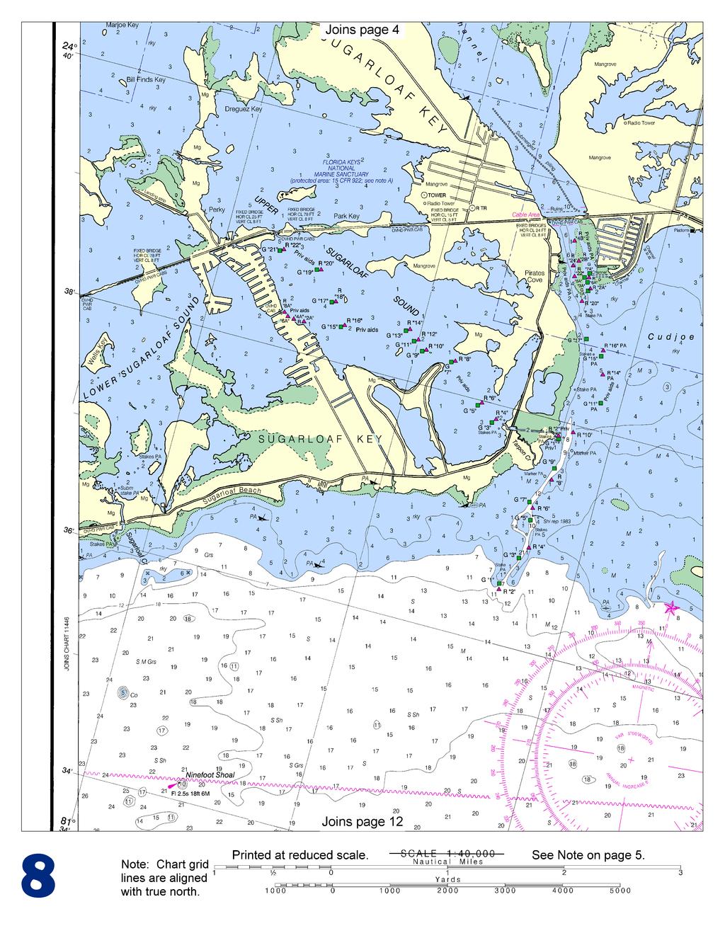
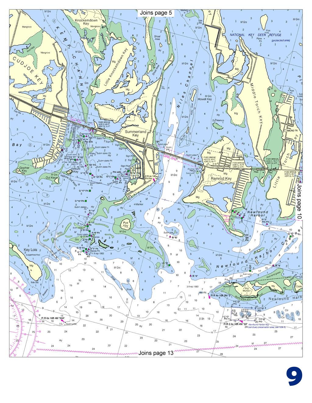
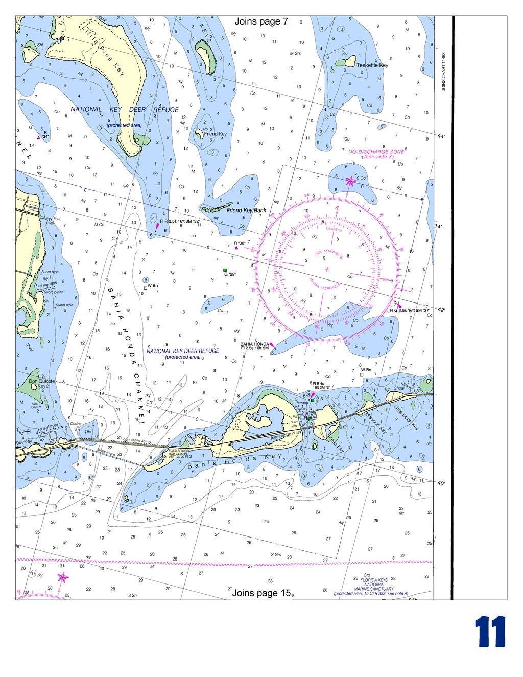
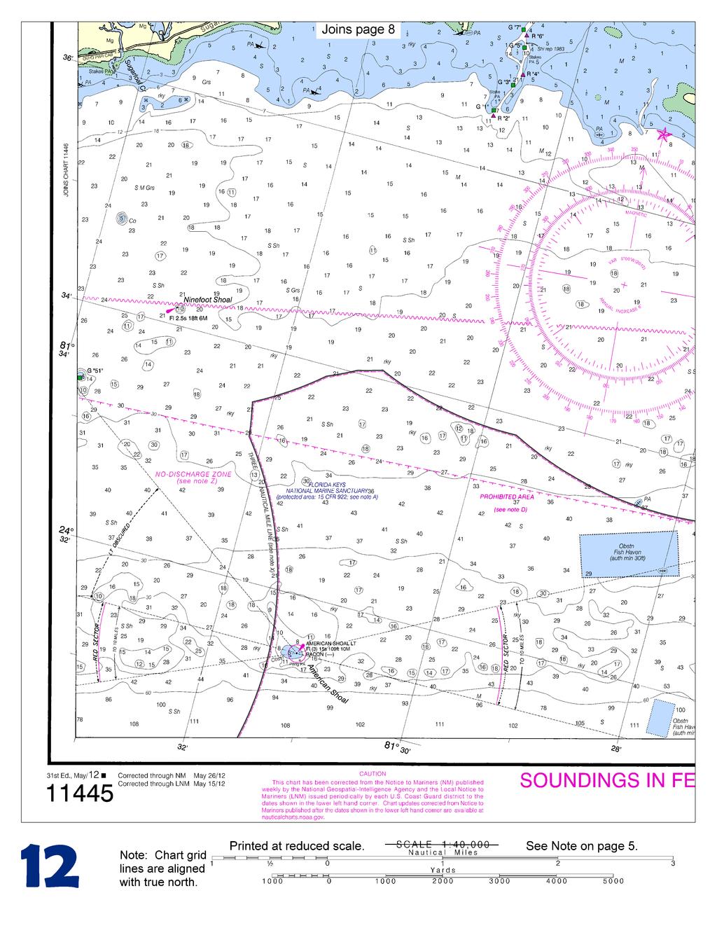
BookletChart. Intracoastal Waterway Bahia Honda Key to Sugarloaf Key NOAA Chart A reduced-scale NOAA nautical chart for small boaters
|
|
|
- Camron Poole
- 5 years ago
- Views:
Transcription


1 BookletChart Intracoastal Waterway Bahia Honda Key to Sugarloaf Key NOAA Chart A reduced-scale NOAA nautical chart for small boaters When possible, use the full-size NOAA chart for navigation.

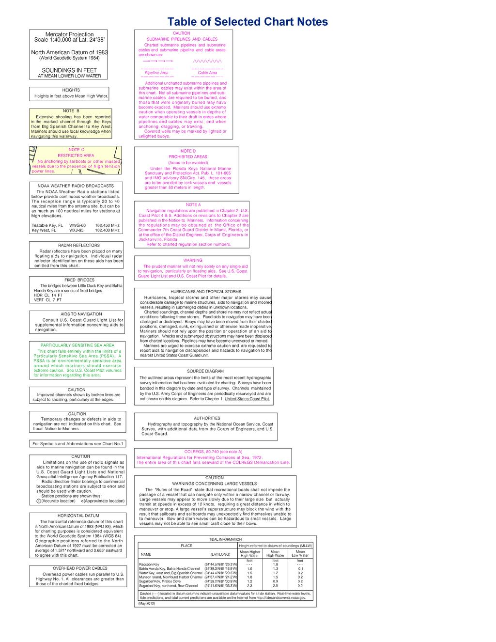
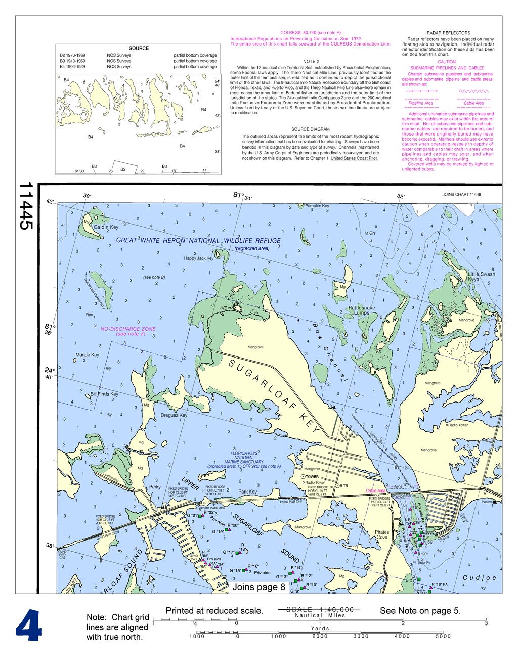
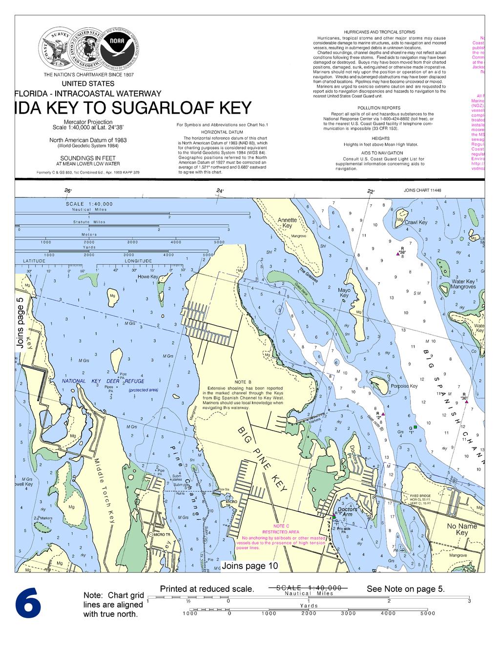
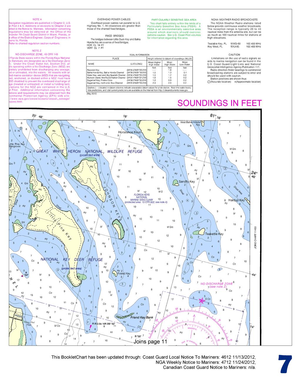
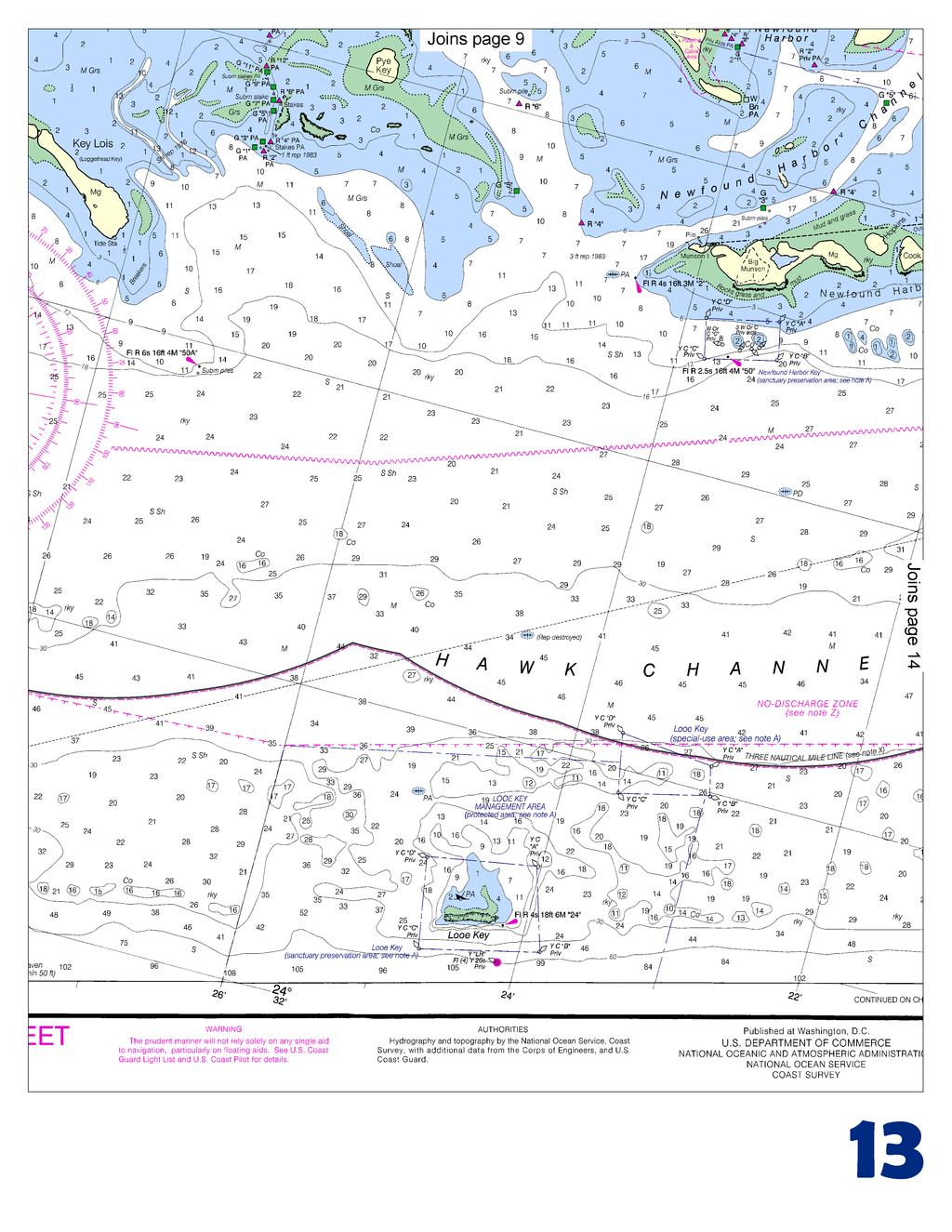
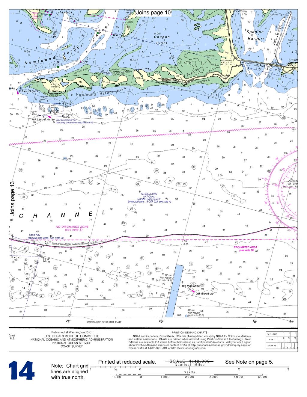
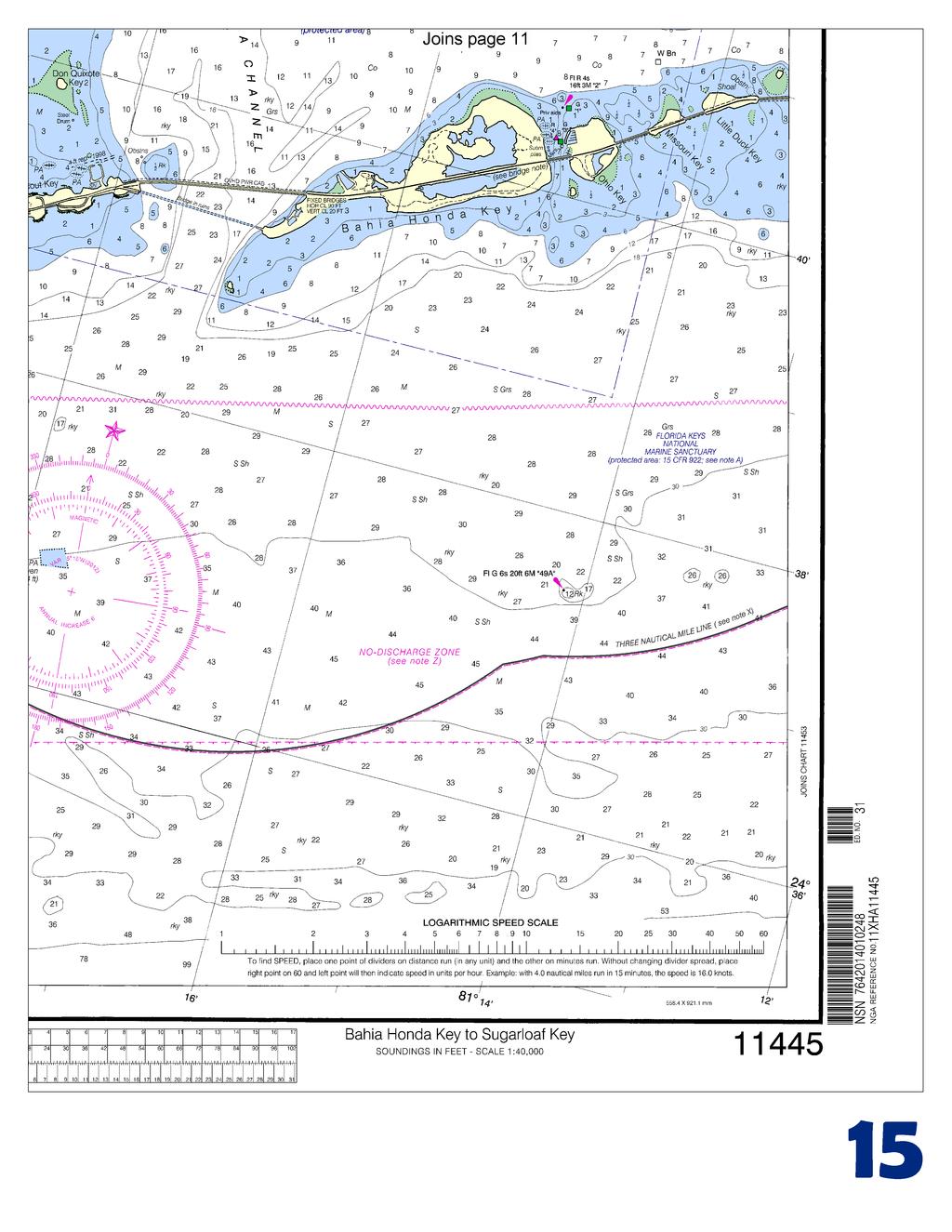
2 Published by the National Oceanic and Atmospheric Administration National Ocean Service Office of Coast Survey NOAA What are Nautical Charts? Nautical charts are a fundamental tool of marine navigation. They show water depths, obstructions, buoys, other aids to navigation, and much more. The information is shown in a way that promotes safe and efficient navigation. Chart carriage is mandatory on the commercial ships that carry America s commerce. They are also used on every Navy and Coast Guard ship, fishing and passenger vessels, and are widely carried by recreational boaters. What is a BookletChart? This BookletChart is made to help recreational boaters locate themselves on the water. It has been reduced in scale for convenience, but otherwise contains all the information of the full-scale nautical chart. The bar scales have also been reduced, and are accurate when used to measure distances in this BookletChart. See the Note at the bottom of page 5 for the reduction in scale applied to this chart. Whenever possible, use the official, full scale NOAA nautical chart for navigation. Nautical chart sales agents are listed on the Internet at This BookletChart does NOT fulfill chart carriage requirements for regulated commercial vessels under Titles 33 and 44 of the Code of Federal Regulations. Notice to Mariners Correction Status This BookletChart has been updated for chart corrections published in the U.S. Coast Guard Local Notice to Mariners, the National Geospatial Intelligence Agency Weekly Notice to Mariners, and, where applicable, the Canadian Coast Guard Notice to Mariners. Additional chart corrections have been made by NOAA in advance of their publication in a Notice to Mariners. The last Notices to Mariners applied to this chart are listed in the Note at the bottom of page 7. Coast Pilot excerpts are not being corrected. For latest Coast Pilot excerpt visit the Office of Coast Survey website at (Selected Excerpts from Coast Pilot) Sombrero Key Light (24 37'40"N., 81 06'39"W.), 142 feet above the water, is shown from a brown, octagonal, pyramidal skeleton tower on pile foundation, enclosing a square dwelling and stair cylinder; a racon is at the light. Moser Channel is northwestward of Sombrero Key Light and 95 miles southwestward of Miami. It affords a passage for vessels of 7 to 8 feet in draft between the Florida Keys from the Straits of Florida to Florida Bay. The swing span of Seven Mile Bridge across Moser Channel has been removed; however, the bridge piers remain. The fixed highway bridge close south of the former swing span has a clearance of 65 feet. The tidal current at the bridge has a velocity of about 1.4 to 1.8 knots. Wind effects modify the current velocity considerably at times; easterly winds tend to increase the northward flow and westerly winds the southward flow. Overfalls that may swamp a small boat are said to occur near the bridge at times of large tides. (For predictions, see the Tidal Current Tables.) Route. A route with a reported controlling depth of 8 feet, in July 1975, from the Straits of Florida via the Moser Channel to the Gulf of Mexico is as follows: From a point 0.5 mile 336 from the center of the bridge, pass 200 yards west of the light on Red Bay Bank, thence 0.4 mile east of the light on Bullard Bank, thence to a position 3 miles west of Northwest Cape of Cape Sable (chart 11431), thence to destination. Bahia Honda Channel (Bahia Honda), 10 miles northwestward of Sombrero Key and between Bahia Honda Key on the east and Scout Key on the west, is the deepest channel between the Straits of Florida and Florida Bay. In 1983, the reported controlling depth was 8 feet from Hawk Channel to Little Pine Key. The passage is crossed by three fixed highway bridges. The southernmost has a clearance of 20 feet over the channel and unlimited vertical clearances at an opening at each end. Mariners are advised to navigate with extreme caution as falling and hanging debris exits in the area. The twin bridges to northward have a clearance of 23 feet over the channel. The direction of the current should be carefully watched when turning northwestward after passing under the bridges in order to avoid being grounded on the banks on either side of the channel. These banks are usually visible. Currents through the passage average 2 knots or more at strength. (For predictions at the southernmost bridge, see the Tidal Current Tables.) From Bahia Honda Channel, vessels may proceed via Big Spanish Channel to the Gulf of Mexico as described in chapter 12. A marina with two boat basins is at the Bahia Honda State Park, on the bayside and near the western end of Bahia Honda Key. In 1981, depths of 4 feet were reported in the unmarked entrance channel, with 7 to 15 feet in the basins. Berths with electricity, water, ice, and a launching ramp are available. A marina on the northwest side of Ohio Key, northeast of Bahia Honda Key, provides berths, gasoline, diesel fuel, water, electricity, ice, limited marine supplies, and a launching ramp; a forklift can handle craft to 23 feet. In 1981, the reported controlling depth was 6 feet in the privately marked entrance channel with 5 to 6 feet reported alongside the berths. Newfound Harbor Keys Anchorage, 16 miles westward of Sombrero Key Light, is in depths of 19 to 22 feet in the channel northeastward of the light at the west end of the keys. Newfound Harbor Channel to the northward is clearly defined by the appearance of the water, and is marked by a light and daybeacons. A strong current sets fair with the channel. In 1983, the reported controlling depth was 4 feet to the western of two bridges at the head, 3.4 miles above the entrance. Clearances at the bridges are 15 feet under the westerly span and 9 feet under the easterly span. A marina is on the west side of Big Pine Key about 0.25 mile south of the easterly span. Gasoline, diesel fuel, water, ice, marine supplies, a 2½-ton forklift, and minor hull and engine repairs are available. In 1981, a depth of 3 feet was reported available to the marina. A marina on the east side of Little Torch Key, just south of the westerly span, provides berths with electricity, gasoline, diesel fuel, water, ice, and a launching ramp are available. In 1991, depths of 4 feet were reported in the approach with 10 feet alongside the berths. 2 U.S. Coast Guard Rescue Coordination Center 24 hour Regional Contact for Emergencies RCC New Orleans Commander 8th CG District (504) New Orleans, LA
3
4

5
6
7
8
9

10
11
12
13
14
15


16 VHF Marine Radio channels for use on the waterways: Channel 6 Inter-ship safety communications. Channel 9 Communications between boats and ship-to-coast. Channel 13 Navigation purposes at bridges, locks, and harbors. EMERGENCY INFORMATION Channel 16 Emergency, distress and safety calls to Coast Guard and others, and to initiate calls to other vessels. Contact the other vessel, agree to another channel, and then switch. Channel 22A Calls between the Coast Guard and the public. Severe weather warnings, hazards to navigation and safety warnings are broadcast here. Channels 68, 69, 71, 72 and 78A Recreational boat channels. Getting and Giving Help Signal other boaters using visual distress signals (flares, orange flag, lights, arm signals); whistles; horns; and on your VHF radio. You are required by law to help boaters in trouble. Respond to distress signals, but do not endanger yourself. Distress Call Procedures Make sure radio is on. Select Channel 16. Press/Hold the transmit button. Clearly say: MAYDAY, MAYDAY, MAYDAY. Also give: Vessel Name and/or Description; Position and/or Location; Nature of Emergency; Number of People on Board. Release transmit button. Wait for 10 seconds If no response Repeat MAYDAY call. HAVE ALL PERSONS PUT ON LIFE JACKETS! NOAA Weather Radio All Hazards (NWR) is a nationwide network of radio stations broadcasting continuous weather information directly from the nearest National Weather Service office. NWR broadcasts official Weather Service warnings, watches, forecasts and other hazard information 24 hours a day, 7 days a week. Quick References Nautical chart related products and information - Online chart viewer - Report a chart discrepancy - Chart and chart related inquiries and comments - Chart updates (LNM and NM corrections) - QR Coast Pilot online - Tides and Currents - Marine Forecasts - National Data Buoy Center - NowCoast web portal for coastal conditions - National Weather Service - National Hurrican Center - Pacific Tsunami Warning Center - Contact Us - For the latest news from Coast Survey, This Booklet chart has been designed for duplex printing (printed on front and back of one sheet). If a duplex option is not available on your printer, you may print each sheet and arrange them back-to-back to allow for the proper layout when viewing. NOAA s Office of Coast Survey The Nation s Chartmaker
Coast Survey Providing Improved Access to Maritime Navigation Products and Services
 Coast Survey Providing Improved Access to Maritime Navigation Products and Services Kurt A. Nelson, Branch Chief CGTP Leland Snyder, Branch Chief FADS Office of Coast Survey Agenda Current Coast Survey
Homework 9: Hurricane Forecasts (adapted from Pipkin et al.)
") November 2010 MAR 110 HW9 Hurricane Forecasts 1 Homework 9: Hurricane Forecasts (adapted from Pipkin et al.) Movement of Hurricanes The advance of a tropical storm or hurricane is controlled by the prevailing
November 2010 MAR 110 HW9 Hurricane Forecasts 1 Homework 9: Hurricane Forecasts (adapted from Pipkin et al.) Movement of Hurricanes The advance of a tropical storm or hurricane is controlled by the prevailing
ANNEX 23 RESOLUTION MSC.231(82) ADOPTION OF AMENDMENTS TO THE EXISTING MANDATORY SHIP REPORTING SYSTEM IN THE GULF OF FINLAND
 ADOPTION OF AMENDMENTS TO THE EXISTING MANDATORY SHIP REPORTING SYSTEM IN THE GULF OF FINLAND") RESOLUTION MSC.231(82) (adopted on 5 December 2006) ADOPTION OF AMENDMENTS TO THE EXISTING MANDATORY SHIP REPORTING SYSTEM IN THE GULF OF FINLAND THE MARITIME SAFETY COMMITTEE, RECALLING Article 28(b)
RESOLUTION MSC.231(82) (adopted on 5 December 2006) ADOPTION OF AMENDMENTS TO THE EXISTING MANDATORY SHIP REPORTING SYSTEM IN THE GULF OF FINLAND THE MARITIME SAFETY COMMITTEE, RECALLING Article 28(b)
No JANUARY 2014 UNITED STATES OF AMERICA. Contents
 2 11 JANUARY 2014 UNITED STATES OF AMERICA Published Weekly by the National Geospatial-Intelligence Agency Prepared Jointly with the National Ocean Service and U.S. Coast Guard Contents Section I Chart
Produced by Canadian Ice Service of. 2 December Seasonal Outlook Gulf of St Lawrence and East Newfoundland Waters Winter
 Environment Canada Environnement Canada Produced by Canadian Ice Service of Environment Canada 2 December 2010 Seasonal Outlook Gulf of St Lawrence and East Newfoundland Waters Winter 2010-2011 2010 Canadian
Building BLocks Do you know what NOAA does? Play this game and find out!
 Discover Your World With NOAA Lionfish Invade U.S. W aters Courte sy Pau Deadly Heat Wave Reaches East Coast la Whit field, NOAA Courtesy NWS FS sy NM Courte Court esy N OAA d Whale Trappe Astronauts Test
DRAFT - Tsunami Response Plan Playbook Santa Cruz Harbor Maritime Community
 DRAFT - Tsunami Response Plan Playbook Santa Cruz Harbor Maritime Community Page 1 Best to display on 11X17 paper Purpose and Use of this Real-time Tsunami Response Plan Playbook PURPOSE: This product
National Maritime Center
 National Maritime Center Providing Credentials to Mariners (Sample Examination) Page 1 of 14 Choose the best answer to the following Multiple Choice Questions. 1. Sometimes foreign charts are reproduced
Routeing. Voyage preparation, -planning and -implementation
 Routeing Voyage preparation, -planning and -implementation Routeing possibilities Weather routeing By own information By external party Climatologic Routeing By charts and books Weather Routeing Basis
The Creation of Accurate, Precise Charts
 The Creation of Accurate, Precise Charts Understanding U.S. Nautical Chart Updates and Their Distribution No doubt, a photo of a grounded vessel is intriguing. A sailboat trapped cockeyed in warm, teal
NOAA Nautical Charts and Coastal and Marine Spatial Planning. Meredith Westington Chief Geographer NOAA/NOS/Office of Coast Survey
 NOAA Nautical Charts and Coastal and Marine Spatial Planning Meredith Westington Chief Geographer NOAA/NOS/Office of Coast Survey Ocean Policy Task Force What is CMSP? A comprehensive, adaptive, integrated,
Advancing Real Time Observations and Coastal Modeling Forecasts-
 Advancing Real Time Observations and Coastal Modeling Forecasts- Moving Forward in a Changing Coastal Landscape Next Generation Navigation-Coastal Operations- Coastal and Nearshore Coastal Operational
What is a tsunami? Capital Regional District Tsunami Frequently Asked Questions (FAQ s) Tsunami (soo-nah-mee)
 Tsunami (soo-nah-mee)") Tsunami (soo-nah-mee) Tsunamis (Japanese translation harbour wave ) are waves with a great distance between crests, and are caused by any widespread, sudden movement of large volumes of water. The tsunami
Tsunami (soo-nah-mee) Tsunamis (Japanese translation harbour wave ) are waves with a great distance between crests, and are caused by any widespread, sudden movement of large volumes of water. The tsunami
Boundary Expansion of Thunder Bay National Marine Sanctuary; Correction and Expansion of Fagatele Bay National Marine
 This document is scheduled to be published in the Federal Register on 12/23/2015 and available online at http://federalregister.gov/a/2015-32265, and on FDsys.gov Billing Code 3510-NK-P DEPARTMENT OF COMMERCE
noaa fisheries service
 Science, Service, Stewardship Compliance Guide for Right Whale Ship Strike Reduction Rule (50 CFR 224.105) noaa fisheries service Mandatory speed restrictions of 10 knots or less are required in Seasonal
Inter State Large Navigable Rivers of the United States
 Inter State Large Navigable Rivers of the United States REVIEW OF NORTH AMERICAN BASINS: GREAT LAKES AND MISSISSIPPI RIVER HELEN A. BROHL, EXECUTIVE DIRECTOR US COMMITTEE ON THE MARINE TRANSPORTATION SYSTEM
Tropical Update. 11 AM EDT Tuesday, October 9, 2018 Hurricane Michael, Tropical Storm Leslie, Tropical Storm Nadine
 Tropical Update 11 AM EDT Tuesday, October 9, 2018 Hurricane Michael, Tropical Storm Leslie, Tropical Storm Nadine This update is intended for government and emergency response officials, and is provided
Marine Navigation Pt. 1. Marine Navigation Pt. 2
 Marine Navigation Marine Navigation Pt. 1 Introduction to Navigation Coordinate Systems Nautical Charts Aids to Navigation Tides Marine Navigation Pt. 2 The Magnetic Compass Obtaining a Fix Dead Reckoning
VOYAGE (PASSAGE) PLANNING
 PLANNING") VOYAGE (PASSAGE) PLANNING Introduction O Passage planning or voyage planning is a procedure of developing a complete description of a vessel's voyage from start to finish. O Production of a passage plan
VOYAGE (PASSAGE) PLANNING Introduction O Passage planning or voyage planning is a procedure of developing a complete description of a vessel's voyage from start to finish. O Production of a passage plan
Marine Weather Hazards, Manual: West Coast Edition By Environment Canada READ ONLINE
 Marine Weather Hazards, Manual: West Coast Edition By Environment Canada READ ONLINE The trail runs along the west to Environment canada s Marine Weather Hazards Manual. mouth of large inlets in the winter.
UNIVERSITY OF WISCONSIN-PARKSIDE TORNADO WARNINGS AND ALERT POLICY ADMINISTRATIVE POLICY NUMBER 39 TABLE OF CONTENTS
 UNIVERSITY OF WISCONSIN-PARKSIDE TORNADO WARNINGS AND ALERT POLICY ADMINISTRATIVE POLICY NUMBER 39 TABLE OF CONTENTS Page 1. PURPOSE 2 2. DEFINITIONS 2 3. GENERAL OVERVIEW 2 4. SPECIFIC PROCEDURES 3 4.1
VISIT MISSISSIPPI GULF COAST CRISIS COMMUNICATION MANUAL 2016
 VISIT MISSISSIPPI GULF COAST CRISIS COMMUNICATION MANUAL 2016 This manual was prepared for Visit Mississippi Gulf Coast staff in the event of a crisis, and will help to distinguish the appropriate course
Tropical Update. 11 AM EDT Wednesday, October 10, 2018 Hurricane Michael, Hurricane Leslie & Tropical Storm Nadine, Caribbean Low (40%)
") Tropical Update 11 AM EDT Wednesday, October 10, 2018 Hurricane Michael, Hurricane Leslie & Tropical Storm Nadine, Caribbean Low (40%) This update is intended for government and emergency response officials,
Tropical Update 11 AM EDT Wednesday, October 10, 2018 Hurricane Michael, Hurricane Leslie & Tropical Storm Nadine, Caribbean Low (40%) This update is intended for government and emergency response officials,
Hurricane Irma Page 1 HURRTRAK RM/Pro 2017 Summary Report for Tampa, FL 09/10/ EDT, Adv. # 46
 Hurricane Irma Page 1 Description of impact to Tampa, FL, Tampa, FL, is expected to receive a major impact from Hurricane Irma. The forecast maximum wind for this location has increased since the last
Tropical Update. 5 AM EDT Monday, October 8, 2018 Tropical Storm Michael, Tropical Storm Leslie, Invest 92L (10%) & African Tropical Wave (50%)
 & African Tropical Wave (50%)") Tropical Update 5 AM EDT Monday, October 8, 2018 Tropical Storm Michael, Tropical Storm Leslie, Invest 92L (10%) & African Tropical Wave (50%) This update is intended for government and emergency response
Tropical Update 5 AM EDT Monday, October 8, 2018 Tropical Storm Michael, Tropical Storm Leslie, Invest 92L (10%) & African Tropical Wave (50%) This update is intended for government and emergency response
Prepared by the North American Ice Service. 4 December Seasonal Outlook Great Lakes Winter
 Prepared by the North American Ice Service A collaboration of the Canadian Ice Service and the National/Naval Ice Center 4 December 2008 Seasonal Outlook Great Lakes Winter 2008-2009 - 1 - Table of contents
U.S. ARMY CORPS OF ENGINEERS
 CORPS FACTS Regulating Mississippi River Navigation Pools U.S. ARMY CORPS OF ENGINEERS BUILDING STRONG Historical Background Federal improvements in the interest of navigation on the Mississippi River
Aid Verification Work List for Division 33, AOR "A" 02-May-12. Annual Night Verification Work List Class I Private Aids and Bridges Only
 Verification Work List for ision 33, "A" Annual Night Verification Work List Class I Pate s and Bridges Only This report has been prepared from data extracted from the 2008 Light List Volume V and updated
Monitoring Scour Critical Bridges During Floods For Local Bridge Owners. Presented by
 Monitoring Scour Critical Bridges During Floods For Local Bridge Owners Presented by SAFETY FIRST DO NOT ENDANGER YOURSELF OR OTHERS WHILE MONITORING BRIDGES DO NOT ENTER FLOOD WATERS FLOOD WATERS INCLUDE
IMO ROUTEING OF SHIPS, SHIP REPORTING AND RELATED MATTERS. Amendments to the existing mandatory ship reporting system In the Gulf of Finland
 INTERNATIONAL MARITIME ORGANIZATION E IMO SUB-COMMITTEE ON SAFETY OF NAVIGATION 52nd session Agenda item 3 NAV 52/3/5 12 April 2006 Original: ENGLISH ROUTEING OF SHIPS, SHIP REPORTING AND RELATED MATTERS
Tropical Update. 5 PM EDT Sunday, October 7, 2018 Tropical Storm Michael, Tropical Storm Leslie, & Invest 92L (30%)
") Tropical Update 5 PM EDT Sunday, October 7, 2018 Tropical Storm Michael, Tropical Storm Leslie, & Invest 92L (30%) This update is intended for government and emergency response officials, and is provided
Tropical Update 5 PM EDT Sunday, October 7, 2018 Tropical Storm Michael, Tropical Storm Leslie, & Invest 92L (30%) This update is intended for government and emergency response officials, and is provided
The Information System in ECDIS
 The Information System in ECDIS Bjørn Åge Hjøllo Product Manager Weather/Routing/Piracy Jeppesen, Norway Nordic Institute of Navigation (NNF); Seminar on enavigation Bergen, May 2011 19 May 2011-1 - enavigation
THAILAND NATIONAL REPORT
 NIOHC18 TH National Report THAILAND NATIONAL REPORT 18 th NORTH INDIAN OCEAN HYDROGRAPHIC COMMISSION (NIOHC) CONFERENCE Goa, India 9 th 12 th April 2018-1 - CONTENTS 1. Hydrographic Office / Service 3
Coastal Response Research Center. Nancy Kinner University of New Hampshire (UNH) Michele Jacobi NOAA ORR. September 27, 2007
 Michele Jacobi NOAA ORR. September 27, 2007") Coastal Response Research Center Nancy Kinner University of New Hampshire (UNH) Michele Jacobi NOAA ORR September 27, 2007 1 Coastal Response Research Center (CRRC) CRRC is partnership between NOAA s Office
Coastal Response Research Center Nancy Kinner University of New Hampshire (UNH) Michele Jacobi NOAA ORR September 27, 2007 1 Coastal Response Research Center (CRRC) CRRC is partnership between NOAA s Office
Coastal Navigation Pt. 1. Coastal Navigation Pt. 2
 Coastal Navigation Pt. 1 Introduction to Navigation Coordinate Systems Nautical Charts Aids to Navigation The Magnetic Compass Coastal Navigation Pt. 2 Tides Obtaining a Fix Dead Reckoning Navigation Rules
Hyperlocal Marine Weather: What s Happening?
 Hyperlocal Marine Weather: What s Happening? André van der Westhuysen 1,2 and Jeff McQueen 1 1 NOAA / National Weather Service National Centers for Environmental Prediction 2 I.M Systems Group, Rockville
National Maritime Center
 National Maritime Center Providing Credentials to Mariners (Sample Examination) Page 1 of 14 Choose the best answer to the following Multiple Choice Questions. 1. If your vessel must pass through a draw
Marine Analysis. LA 23 New. Louisiana. Prepared by:
 Gulf Intracoastal Waterway (GIWW) Marine Vessel Trafficc Analysis LA 23 New Orleans Gulf Coastt Railway Relocation PE/NEPA Project Jefferson and Plaquemines Parishes, Louisiana RPC Task LA23RR1 RPC/FRA
MailASail Automatic Weather Responder
 MailASail Automatic Weather Responder About: This weather service is a simple system to offer popular weather forecasts and charts by email. Our goal is to provide a deliberately limited subset of all
Tropical Update 11 AM EDT Thursday, September 6, 2018 Tropical Depression Gordon, Hurricane Florence, Invest 92L (90%) & African Tropical Wave (50%)
 & African Tropical Wave (50%)") Tropical Update 11 AM EDT Thursday, September 6, 2018 Tropical Depression Gordon, Hurricane Florence, Invest 92L (90%) & African Tropical Wave (50%) This update is intended for government and emergency
Tropical Update 11 AM EDT Thursday, September 6, 2018 Tropical Depression Gordon, Hurricane Florence, Invest 92L (90%) & African Tropical Wave (50%) This update is intended for government and emergency
STUDY GUIDE TABLE OF CONTENTS WITH REPORT EXHIBITS. LIST OF ACRONYMS...iv. OVERVIEW OF THE STUDY GUIDE...v SECTION I - PREPARATION AND TOOLS...
 STUDY GUIDE TABLE OF CONTENTS WITH REPORT EXHIBITS SUBJECT-SECTION SECTION-PAGE LIST OF ACRONYMS...iv OVERVIEW OF THE STUDY GUIDE...v SECTION I - PREPARATION AND TOOLS...1-1 SECTION II- FEDERAL SHORT RANGE
U.S. National Report
 U.S. National Report U.S.-Canada Regional Hydrographic Commission Meeting RDML Gerd F. Glang, National Hydrographer, Director Office Coast Survey RDML Timothy Gallaudet, Hydrographer of the Navy John E.
NAVIGATION AND VESSEL INSPECTION CIRCULAR NO
 COMDTPUB P16700.4 NVIC 13-92 15 Dec 1992 NAVIGATION AND VESSEL INSPECTION CIRCULAR NO. 13-92 Electronic Version for Distribution Via the World Wide Web Subj: Captain of the Port Zone Boundaries 1. PURPOSE.
Tropical Update. 5 AM EDT Thursday, September 7, 2017 Hurricane Irma, Hurricane Jose, and Hurricane Katia
 Tropical Update 5 AM EDT Thursday, September 7, 2017 Hurricane Irma, Hurricane Jose, and Hurricane Katia This update is intended for government and emergency response officials, and is provided for informational
Tropical Update. 5 PM EDT Sunday, September 10, 2017 Hurricane Irma, Hurricane Jose, Tropical Wave (60%)
") Tropical Update 5 PM EDT Sunday, September 10, 2017 Hurricane Irma, Hurricane Jose, Tropical Wave (60%) This update is intended for government and emergency response officials, and is provided for informational
Tropical Update 5 PM EDT Sunday, September 10, 2017 Hurricane Irma, Hurricane Jose, Tropical Wave (60%) This update is intended for government and emergency response officials, and is provided for informational
MARINE FORECAST INFORMATION FOR COASTAL B.C. WATERS
 September 13, 2016 Roger Palmer MARINE FORECAST INFORMATION FOR COASTAL B.C. WATERS Mariners cruising the coastal waters of British Columbia have several sources of forecast information available to them:
1.6 Getting Started on Resources. Time for Trivial Pursuit!
 06, 12, and 18Z. Note this is easy to do if you are looking for data within the past 24 hours. It is doable but harder to sift through the archives to find older data. From a practical point of view this
NATIONAL REPORT OF ESTONIA
 BSHC 21 th Conference 27-29 Sept 2016 Klaipeda, Lithuania NATIONAL REPORT OF ESTONIA Executive summary This report summarizes the activities of the Estonian Maritime Administration in the field of hydrography
LESSON PLAN 15. Career and Educational Development, Science, Health and Physical Education, History, ELA, Math, Social Studies
 Title: Time and Tides Wait for No One Content Area Subjects: Career and Educational Development, Science, Health and Physical Education, History, ELA, Math, Social Studies Grade level(s): Grades 3-12+
An upper to mid level circulation (Low) in the NW Caribbean is
 in the NW Caribbean is") WEEKLY WEATHER OUTLOOK BELIZE, CENTRAL AMERICA PERIOD: Monday-Monday, Oct. 1 October 8, 2012 DATE ISSUED: Monday, Oct 1, 2012 6:00 am RFrutos EcoSolutions & Services SYNOPSIS: An upper to mid level circulation
WEEKLY WEATHER OUTLOOK BELIZE, CENTRAL AMERICA PERIOD: Monday-Monday, Oct. 1 October 8, 2012 DATE ISSUED: Monday, Oct 1, 2012 6:00 am RFrutos EcoSolutions & Services SYNOPSIS: An upper to mid level circulation
PRECAP. Rivers Breakout Session Final Presentation CAPSTONE 14
 Rivers Breakout Session Final Presentation CAPSTONE 14 Rivers Session Team -Army Corps of Engineers -3 Divisions, 4 Districts -Navigation & Emergency Management -U.S. Coast Guard -U.S. Department of Transportation
July 24, 2017 Annapolis, MD Bryan A. Jackson NWS Sterling, VA Marine Program Leader
 When Wicked Weather Strikes Insights into Chesapeake Bay Weather July 24, 2017 Annapolis, MD Bryan A. Jackson NWS Sterling, VA Marine Program Leader Mission of the National Weather Service Provide climate,
Western Alaska Buoy Deployment and Data Streaming. Author of Report Molly McCammon, AOOS,
 1. PROJECT INFORMATION Title: Western Alaska Buoy Deployment and Data Streaming Report period December 31, 2012 May 27, 2015 Report submission date May 27, 2015 (rec d 27 May; rev d 27 May; resp d 27 May;
Title: NOAA National Ocean Service Response Team efforts during the 2004 Hurricane Season
 Title: NOAA National Ocean Service Response Team efforts during the 2004 Hurricane Season LCDR Rick Fletcher, OCS/NOS/NOAA Abstract: The 2004 Atlantic Hurricane Season has been one of the most active and
Careful, Cyclones Can Blow You Away!
 Title: Careful, Cyclones Can Blow You Away! (Meteorology) Grade(s): 6-8 Introduction: Most people associate twisters with tornadoes, but in fact tropical twisters come from hurricanes. Hurricanes are what
Atlantic Basin Satellite Image
 Tropical Update 11 AM EDT Friday, September 7, 2018 Tropical Depression Gordon, Tropical Storm Florence, Potential Tropical Cyclone #8 (90%), Invest 92L (90%) This update is intended for government and
GLOS HarborView A mapping mashup that supports recreational boating on the Great Lakes
 GLOS HarborView A mapping mashup that supports recreational boating on the Great Lakes David Hart GIS Specialist Aquatic Science Center University of Wisconsin-Madison GLOS Annual Meeting Ann Arbor, Michigan
FOURTH INTERNATIONAL PORT METEOROLOGICAL OFFICERS WORKSHOP AND SUPPORT TO GLOBAL OCEAN OBSERVATIONS USING SHIP LOGISTICS
 FOURTH INTERNATIONAL PORT METEOROLOGICAL OFFICERS WORKSHOP AND SUPPORT TO GLOBAL OCEAN OBSERVATIONS USING SHIP LOGISTICS PMO-IV 8-10 DEC 2010, ORLANDO, FLORIDA, USA 1 This presentation is generally for
Weather Merit Badge Workbook
 Merit Badge Workbook This workbook can help you but you still need to read the merit badge pamphlet. This Workbook can help you organize your thoughts as you prepare to meet with your merit badge counselor.
CANADIAN HYDROGRAPHIC SERVICE
 CANADIAN HYDROGRAPHIC SERVICE Surveying and Charting Canada s Waters Since 1883 Ilulisat Maritime Workshop 2017 The Importance and Need for Hydrography Denis Hains, Hydrographer General of Canada & Director
: : User Manual: : - 10 December
 : : User Manual: : - 0 December 06 - : : User Manual: : Table of Contents. Map Control. How to move a map. How to zoom in and out a map 4. How to inquire Ocean Currents. How to inquire predicted current
Unit 5: NWS Hazardous Weather Products. Hazardous Weather and Flooding Preparedness
 Unit 5: NWS Hazardous Weather Products Objectives Describe the mission of the NWS Describe the basic organizational structure of the NWS Explain the purpose of various NWS products Explain how Probability
Environmental Response Management Application
 Environmental Response Management Application Coastal Response Research Center Nancy Kinner, Michele Jacobi, Rob Braswell, Kurt Schwehr & Amy Merten RRT III May 14, 2008 1 Talk Outline Overview of Center
METEOROLOGICAL WARNINGS STUDY GROUP (METWSG)
") METWSG/4-SN No. 6 12/3/12 METEOROLOGICAL WARNINGS STUDY GROUP (METWSG) FOURTH MEETING Montréal, 15 to 18 May 2012 Agenda Item 6: Wind shear, turbulence and tsunami warnings TSUNAMI INFORMATION (Presented
METWSG/4-SN No. 6 12/3/12 METEOROLOGICAL WARNINGS STUDY GROUP (METWSG) FOURTH MEETING Montréal, 15 to 18 May 2012 Agenda Item 6: Wind shear, turbulence and tsunami warnings TSUNAMI INFORMATION (Presented
National Maritime Center
 National Maritime Center Providing Credentials to Mariners Q388 Navigation General-Rivers (Sample Examination) Page 1 of 14 Choose the best answer to the following Multiple Choice Questions. 1. Under the
National Report of Finland
 National Report of 1. Finnish Hydrographic Office The Finnish Hydrographic Office (FHO) is responsible for nautical charting over the Finnish sea area and the most important inland water bodies. This covers
COUNTRY REPORT ON CARTOGRAPHIC ACTIVITIES IN SINGAPORE ( ) Submitted by Singapore **
 Submitted by Singapore **") UNITED NATIONS E/CONF.97/5/CRP. 9 ECONOMIC AND SOCIAL COUNCIL Seventeenth United Nations Regional Cartographic Conference for Asia and the Pacific Bangkok, 18-22 September 2006 Item 6 (b) of the provisional
UNITED NATIONS E/CONF.97/5/CRP. 9 ECONOMIC AND SOCIAL COUNCIL Seventeenth United Nations Regional Cartographic Conference for Asia and the Pacific Bangkok, 18-22 September 2006 Item 6 (b) of the provisional
University of New Hampshire Scholars' Repository
 University of New Hampshire University of New Hampshire Scholars' Repository Center for Coastal and Ocean Mapping Center for Coastal and Ocean Mapping 3-2009 Environmental Response Management Application
Tropical Update. 5 AM EDT Tuesday, September 12, 2017 Post-Tropical Cyclone Irma, Hurricane Jose, & Tropical Wave (10%)
") Tropical Update 5 AM EDT Tuesday, September 12, 2017 Post-Tropical Cyclone Irma, Hurricane Jose, & Tropical Wave (10%) This update is intended for government and emergency response officials, and is provided
Tropical Update 5 AM EDT Tuesday, September 12, 2017 Post-Tropical Cyclone Irma, Hurricane Jose, & Tropical Wave (10%) This update is intended for government and emergency response officials, and is provided
Homework Assignment IV. Weather Exercises
 Page 1 of 5 EENS 3050/6050 Tulane University Natural Disasters Prof. Stephen A. Nelson Homework Assignment IV. Weather Exercises This document last updated on 16-Nov-2016 1. Go to the following link to
THAILAND NATIONAL REPORT
 NIOHC14 TH National Report THAILAND NATIONAL REPORT 14 th NORTH INDIAN OCEAN HYDROGRAPHIC COMMISSION (NIOHC) CONFERENCE Bangkok, Thailand 26 th 28 th February 2014 1 CONTENTS 1. Hydrographic Office / Service...
Alaska Ocean Observing System 101 Anchorage, Alaska
 Alaska Ocean Observing System 101 Anchorage, Alaska Molly McCammon, Director Alaska Ocean Observing System (AOOS) A Regional Observing System within the Integrated Ocean Observing System www.aoos.org IOOS
PUBLIC SAFETY POWER SHUTOFF POLICIES AND PROCEDURES
 PACIFIC GAS AND ELECTRIC COMPANY PUBLIC SAFETY POWER SHUTOFF POLICIES AND PROCEDURES SEPTEMBER 2018 1 PACIFIC GAS AND ELECTRIC COMPANY PUBLIC SAFETY POWER SHUTOFF POLICIES AND PROCEDURES SEPTEMBER 2018
Ocean Observatories Initiative
 Ocean Observatories Initiative Pioneer Array Micro-Siting Process Meeting URI Coastal Institute November 15, 2010 Jean McGovern, NSF Al Plueddemann, WHOI Action Items from 5 Oct Meeting NSF will address
教育啓蒙への利活用を考慮した防災技術情報アーカイブシステムの開発 (2013)
") Title Program 1 : Preparedness Program fo Impact Author(s) SOE, Aye Aye Citation 教育啓蒙への利活用を考慮した防災技術情報アーカイブシステムの開発 (2013) Issue Date 2013-06 URL http://hdl.handle.net/2433/175523 Right Type Article Textversion
Title Program 1 : Preparedness Program fo Impact Author(s) SOE, Aye Aye Citation 教育啓蒙への利活用を考慮した防災技術情報アーカイブシステムの開発 (2013) Issue Date 2013-06 URL http://hdl.handle.net/2433/175523 Right Type Article Textversion
GEOL 308 Natural Hazards Activity 2: Weather and Flooding
 DUE Tuesday February 7 Note: You will need to complete Part I by February 3! Part I: Weather Visit http://www.weather.gov This is the National Weather Service site. It includes a quick overview of national
Safety Thursday Weather Resources (pt. 2) June 27, By Mark Thornton
 June 27, By Mark Thornton") Safety Thursday Weather Resources (pt. 2) June 27, 2013 By Mark Thornton Introduction This Safety Thursday article, the second in a two part series, focuses on the challenges of monitoring weather conditions
Safety Thursday Weather Resources (pt. 2) June 27, 2013 By Mark Thornton Introduction This Safety Thursday article, the second in a two part series, focuses on the challenges of monitoring weather conditions
Darren Wright Maritime Services Program Manager Center for Operational Oceanographic Products and Services (CO-OPS)
") Darren Wright Maritime Services Program Manager Center for Operational Oceanographic Products and Services (CO-OPS) Center for Operational Oceanographic Products and Services (CO-OPS) National Water Level
Darren Wright Maritime Services Program Manager Center for Operational Oceanographic Products and Services (CO-OPS) Center for Operational Oceanographic Products and Services (CO-OPS) National Water Level
THAILAND NATIONAL REPORT
 NIOHC19 TH National Report THAILAND NATIONAL REPORT 19 th MEETING OF THE NORTH INDIAN OCEAN HYDROGRAPHIC COMMISSION (NIOHC19) MUSCAT, OMAN 25 th 28 th March 2019-1 - CONTENTS 1. Hydrographic Office / Service
Hurricane Matthew Threats and Impacts Briefing for Eastern NC
 Hurricane Matthew Threats and Impacts Briefing for Eastern NC October 6 th, 2016 Date/Time Created: 10/6/2016, Noon EDT National Weather Service Newport/Morehead City, NC Hurricane Matthew Key Points Changes
Coastal and Hydraulics Laboratory
 ERDC/CHL TR-05-6 Texas City Ship Channel Deepening Study, Hydrodynamic Model Lisa M. Lee, Jennifer N. Tate, and R. C. Berger August 2005 Coastal and Hydraulics Laboratory Approved for public release; distribution
Counselor s Name: Counselor s Ph #: 1) Define meteorology. Explain how the weather affects farmers, sailors, aviators,
 Define meteorology. Explain how the weather affects farmers, sailors, aviators,") Weather Merit Badge Workbook This workbook is not required but is designed to help you with this merit badge. No one can add or subtract from the Boy Scout Requirements #33215. Use page backs & add pages
Weather Merit Badge Workbook This workbook is not required but is designed to help you with this merit badge. No one can add or subtract from the Boy Scout Requirements #33215. Use page backs & add pages
[03/18] Admiralty Charts affected by the Publication List. denotes chart available in the Admiralty Raster Chart Service series. 1.
![[03/18] Admiralty Charts affected by the Publication List. denotes chart available in the Admiralty Raster Chart Service series. 1.](/thumbs/77/75945417.jpg "[03/18] Admiralty Charts affected by the Publication List. denotes chart available in the Admiralty Raster Chart Service series. 1.") Admiralty Charts affected by the Publication List [03/18] Admiralty Charts International Charts 107 INT 1040 129 INT 1041 134 INT 1146 275 INT 1148 281 INT 1152 286 INT 1400 288 INT 1401 299 INT 1402 777
Admiralty Charts affected by the Publication List [03/18] Admiralty Charts International Charts 107 INT 1040 129 INT 1041 134 INT 1146 275 INT 1148 281 INT 1152 286 INT 1400 288 INT 1401 299 INT 1402 777
Hurricane Wilma Post Storm Data Acquisition Estimated Peak Wind Analysis and Storm Tide Data. December 27, 2005
 Hurricane Wilma Post Storm Data Acquisition Estimated Peak Wind Analysis and Storm Tide Data December 27, 2005 Hurricane Wilma was the sixth major hurricane of the record-breaking 2005 Atlantic hurricane
Cascadia Seismic Event Planning for the Maritime Community
 Cascadia Seismic Event Planning for the Maritime Community Jonathan Allan, Oregon Dept. of Geology and Mineral Industries Presentation to Annual Pacific Northwest Waterways Association Meeting (PNWA) October
National / Naval Ice Center (NIC) Operations Brief This brief is UNCLASSIFIED
 Operations Brief This brief is UNCLASSIFIED") National / Naval Ice Center (NIC) Operations Brief This brief is UNCLASSIFIED Christopher Szorc, Senior Ice Analyst/Forecaster USCG USN NOAA Outline NIC s mission is to provide timely, accurate and relevant
National / Naval Ice Center (NIC) Operations Brief This brief is UNCLASSIFIED Christopher Szorc, Senior Ice Analyst/Forecaster USCG USN NOAA Outline NIC s mission is to provide timely, accurate and relevant
Common Core Reading Passage
 Directions: Please read the following Common Core Reading passage and answer the questions that follow. Common Core Reading Passage Forecasting Severe Weather to Communities Helps Them Prepare By Alissa
Visual Notices to mariners & Navigational Warnings
 Visual Notices to mariners & Navigational Warnings 22 MAY, 2017 Hydrographic and Oceanographic Department Talking about: Visual Notices to Mariners & Navigational Warning System Text on a paper Text information
Bayview Marina. Cyclone Response Plan
 Bayview Marina Cyclone Response Plan November 2015 1 Cyclone Emergency Response Plan Purpose Being prepared to handle an event be it Cyclonic, Marine Accident or Oil Spill is the major factor in ensuring
Parish of Ascension. ASCENSION PARISH SITUATIONAL REPORT 06 August 2008 As of: 1600 Hours
 Parish of Ascension OFFICE OF HOMELAND SECURITY AND EMERGENCY PREPAREDNESS Tommy Martinez Parish President Richard A. Webre Director ASCENSION PARISH SITUATIONAL REPORT 06 August 2008 As of: 1600 Hours
GC Briefing. Weather Sentinel Tropical Storm Michael. Status at 8 AM EDT (12 UTC) Today (NHC) Discussion. October 11, 2018
 Today (NHC) Discussion. October 11, 2018") GC Briefing Weather Sentinel Tropical Storm Michael October 11, 2018 After making landfall as a high-end category-4 hurricane on the Florida Panhandle, Michael weakened to tropical storm status early this
GC Briefing Weather Sentinel Tropical Storm Michael October 11, 2018 After making landfall as a high-end category-4 hurricane on the Florida Panhandle, Michael weakened to tropical storm status early this
Job Description. 1) To provide a range of meteorological services, including a forecaster consultancy service.
 To provide a range of meteorological services, including a forecaster consultancy service.") Job Description Job Title: Department: Division: Location: Grade: Responsible to: Trainee Meteorological Forecaster Department of Infrastructure Ports Division Isle of Man Airport Trainee Met Officer Senior
Job Description Job Title: Department: Division: Location: Grade: Responsible to: Trainee Meteorological Forecaster Department of Infrastructure Ports Division Isle of Man Airport Trainee Met Officer Senior
Hurricane Irma Page 1 HURRTRAK RM/Pro 2017 Summary Report for Tampa, FL 09/09/ EDT, Adv. # 43
 Hurricane Irma Page 1 Description of impact to Tampa, FL, Tampa, FL, is expected to receive a major impact from Hurricane Irma. The forecast maximum wind for this location has decreased since the last
Subtropical Storm Ana
 Subtropical Storm Ana Threat Assessment for northeast South Carolina & southeast North Carolina Created 745 AM Fri May 8, 2015 Reid Hawkins, Science Officer National Weather Service Wilmington, NC 1 New
Tropical Update. 5 PM EDT Tuesday, September 5, 2017 Hurricane Irma, Tropical Storm Jose, and Tropical Depression Thirteen
 Tropical Update 5 PM EDT Tuesday, September 5, 2017 Hurricane Irma, Tropical Storm Jose, and Tropical Depression Thirteen This update is intended for government and emergency response officials, and is
Background Information
 Oceanography LAB #1: Marine Charts and Navigation Background Information Latitude and Longitude A coordinate is an address a means of designating location. Most coordinate systems involve a network of
Seabed 2030: A Call to Action
 Seabed 2030: A Call to Action Rear Adm. Shepard Smith NOAA Office of Coast Survey shep.smith@noaa.gov Introduction Many people like me start speeches about mapping the ocean with we know more about the
Add NOAA nowcoast Layers to Maps
 WebEOC Maps Add-on Quick Reference Guide Add NOAA nowcoast Layers to Maps Overview With Maps Add-on, you can configure an unlimited number of map layers. These layers allow you to control the data you
HURRICANE MATTHEW A GIS PERSPECTIVE GLYNN COUNTY GIS
 HURRICANE MATTHEW A GIS PERSPECTIVE GLYNN COUNTY GIS Situation September 25 th October 9 th 2016 Hurricane Matthew tracked its way up the east coast bringing hurricane force winds and flooding from Haiti
NATIONAL REPORT OF POLAND
 NATIONAL REPORT OF Executive summary This report summarizes activities of the Hydrographic Office/Service in the field of hydrography since the previous Baltic Sea Hydrographic Commission 18th Conference