Marine Analysis. LA 23 New. Louisiana. Prepared by:
|
|
|
- Natalie Williams
- 6 years ago
- Views:
Transcription

 Marine")


1 Gulf Intracoastal Waterway (GIWW) Marine Vessel Trafficc Analysis LA 23 New Orleans Gulf Coastt Railway Relocation PE/NEPA Project Jefferson and Plaquemines Parishes, Louisiana RPC Task LA23RR1 RPC/FRA Grant # FR RLD Prepared by: HDR Engineering, Inc. and Burk Kleinpeter, Inc. August 2015
2 Table of Contents 1.0 INTRODUCTION Methodology MARINE VESSEL TRAFFIC PATTERNS Summary Information Bridge Operation Trends Vessel s Algiers Lock REGIONAL NAVIGATION Regional Clearances and Obstructions Planned Projects FINDINGS List of Figures and Tables Figure 1. Project Area Map... 2 Figure 2. Regional Overview Map... 6 Figure 3. Total Marine Traffic on GIWW Annual Comparison by Month... 6 Figure 4. Vessels by : Number and Percent of Total... 8 Figure 5. Regional Navigational Clearances and Obstructions Table 1. Bridge Tender Report Annual Summary... 4 Table 2. Comparison of Number of Vessels According to Previous Studies... 7 Table 3. USACE Algiers Lock Marine Traffic... 8 Table 4. Regional Navigational Restrictions Summary August 2015 i
3 1.0 INTRODUCTION The New Orleans Gulf Coast (NOGC) Railway is a former Union Pacific Railroad (UPRR) branch line traversing the west bank of Jefferson, Orleans, and Plaquemines Parishes. It is a 32 mile long railroad that interchanges with the UPRR in Westwego. The railroad provides a single track with accompanying sidings, serving over twenty switching and industrial customers and is the only railroad operating east of Avondale, LA on the Westbank. This marine vessel traffic study is being undertaken as part of an environmental assessment (EA) for the relocation of the NOGC Railway. The EA will consider alternatives to reroute the NOGC Railway away from Louisiana Highway 23 (LA 23)/Belle Chasse Highway towards the Harvey Canal industrial area. The NOGC Railway currently crosses the Gulf Intracoastal Waterway (GIWW) with a 387 foot long vertical lift bridge providing 125 feet of horizontal clearance, 5 feet of vertical clearance above mean high water when closed and 102 feet of vertical clearance when open. The NOGC Rail Bridge is paralleled by the Louisiana Highway 23 (LA 23)/Belle Chasse Highway Perez Bridge which was constructed in The Perez Bridge is a vertical lift bridge, providing 40 feet of vertical clearance above mean high water when closed and 100 feet of vertical clearance when open. It also provides 125 feet of horizontal clearance. Both the NOGC Rail Bridge and the Perez Bridge are operated by the Louisiana Department of Transportation and Development (LADOTD). 1.1 Methodology The scope of this marine vessel traffic study is to identify current marine vessel characteristics and use this data to inform the design of a new railway bridge over the GIWW near the future Peters Road Extension and its associated bridge over the GIWW (see Figure 1). It should be noted that empirical field data are limited to the Belle Chasse/LA 23 Bridge as no other moveable spans are located on the Algiers Cut off Canal segment of the GIWW. This will include a determination of frequency of bridge openings by vessel size through the analysis of bridge tenders reports. This information was supplemented by a review of existing studies and correspondence with LADOTD, United States Army Corps of Engineers (USACE) and United States Coast Guard (USCG). August

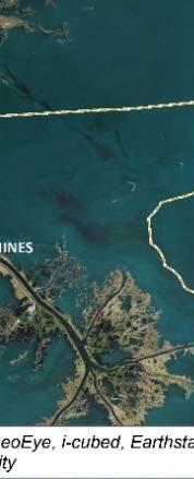
4 GIWWMarineVesselTrafficAnalysis LA23NewOrleansGulfCoastRailwayRelocationPE/NEPAProject Figure1.ProjectAreaMap August2015 2
5 2.0 MARINE VESSEL TRAFFIC PATTERNS Whereas the NOGC Rail Bridge remains in the raised position unless a train is approaching, marine vessel traffic patterns for the portion of the GIWW extending from the GIWW junction with the Harvey Canal to the GIWW junction with the Mississippi River at the Algiers Lock are documented by bridge tender reports for the Perez Bridge. The daily logs document each occurrence when the bridge is raised for a marine vessel to pass below. At each opening, the bridge tender records the date and time of the opening as well as the vessel s name, height, vessel type, and direction of travel. For this report, only the date and heights of vessels passing under the Perez Bridge and subsequently the NOGC Rail Bridge were of concern. As these reports only document when the bridge is raised, the following analysis reflects those vessels requiring an opening. Data on total marine traffic on the canal, including vessels less than 40 feet in height, which do not require an opening, are not available and therefore are not included in the analysis that follows. As such, when marine traffic is referenced in this report, it refers only to that traffic which was recorded in the LADOTD s tender reports. 2.1 Summary Information Bridge tender reports dating from January 2012 to December 2014 were analyzed using Microsoft Excel to determine trends in bridge operation activity and vessel characteristics. The reports were grouped by year and then by month. Table 1 shows the summary data, by month, year, and for the two year study period, of each quantifiable characteristics found in the bridge tender s report. This includes: In 2012, the 6,099 vessels passed under the bridge while raised, averaging 47.0 feet in height and 8 openings per day. In 2013, the 3,715 vessels passed under the bridge while raised, averaging 47.4 feet in height and 6 openings per day. In 2014, the 5,744 vessels passed under the bridge while raised, averaging 47.4 feet in height and 7 openings per day. Over the three year study period, the bridge opened for 15,558 vessels, averaging 47.3 feet in height and 7 openings per day. August
6 Table 1. Bridge Tender Report Annual Summary Average Number of Average Maximum 85% Percentile 2012 Openings per Vessels Day January February March April May June July August September October November December Annual 8 6, Average Openings per Day Number of Vessels Average Maximum 85% Percentile January February March April May June July August September October November December Annual 6 3, August
7 Table 1. Bridge Tender Report Annual Summary (Continued) Average Number of Maximum 85% Percentile 2014 Openings per Average Vessels Day January February March April May June July August September October November December Annual 7 5, Three Year Averages/ Total * 7 6,000/ 15,558 * Data Source: Perez Bridge Tenders Reports, Note: Although the maximum vertical clearance is generally 102 above mean high water, during lower water conditions slightly larger vessels can be accommodated. 2.2 Bridge Operation Trends During the observation period, marine traffic tended to remain relatively static throughout the year, with variability not following seasonal or monthly patterns. Below, Figure 3 shows a year to year comparison of total marine traffic passing under the Perez Bridge on the GIWW by month. The low numbers of vessels counted during the 3.5 month period (April to mid July) in 2013 is likely due to major repairs made to the USACE operated Algiers Lock located just over 3.5 miles northeast of the Perez Bridge. 1 Also of note, after Hurricane Isaac in late August 2012, no other major tropical storms/ hurricanes made landfall along the Gulf Coast throughout 2013 and 2014 (see Figures 2 and 5 for Regional Overview). 1 Based up on communication with USACE Administrator Victor Landry on April 7, August


8 LA 23 New Orleans Gulf Coast Railway Relocation PE/NEPA Project Figure 2. Regional Overview Map Figure 3. Total Marine Traffic on GIWW Annual Comparison by Month Data Source: Perez Bridge Tenders Reports, Note: Major repairs to the USACE Algiers Lock occurring over several months during caused significant reductions along this section of the GIWW. Similar studies of marine traffic for the Perez Bridge were conducted in and , using bridge tender reports from and , respectively.. Based on comparison of 2 Belle Chas sse Highway Bridge over the Intracoastal Waterway: Planning/Line and Grade Study. Conducted by BKI in June Replace Belle Chasse Tunnel and Bridge Stage 0 Feasibility Study. Conducted by BKI in August
9 results of those studies and the findings of analysis conduct here, average monthly traffic has increased from 284 vessels to 432 vessels. This represents a 34 percent increase in vessel traffic from 1993 to 2014 and an 18 percent increase since Table 2 shows the comparative data. This is somewhat in conflict with anecdotal reports that traffic on this portion of the GIWW is declining as maritime industries move west towards the Houma Thibodeaux area. Table 2. Comparison of Number of Vessels According to Previous Studies Month Average Number of Vessels January February March April May June July August September October November December Average Data Sources: Perez Bridge Tenders Reports, , , and ; Belle Chasse Highway Bridge over the Intracoastal Waterway: Planning/Line and Grade Study. Conducted by BKI in June data not available for June September. 2.3 Vessel s The Perez Bridge has a closed vertical clearance of 40 feet and an open vertical clearance of 100 feet. 4 According to monthly and annual summaries compiled from bridge tenders reports, the average vessel traveling on this portion of the GIWW has a height of 47.3 feet. The 85th percentile height is 50 feet. These statistics do not account for vessels that did not require the bridge to be opened because the vessels were smaller than the 40 foot clearance. Figure 4 shows the number and percent of vessels that required the bridge to open during the Bridge can be opened higher than 100 ft. by bridge engineer (electrician) as per activity log, February 21, August


10 LA 23 New Orleans Gulf Coast Railway Relocation PE/NEPA Project 2014 study period by height. The data shows that 75 percent of vessels had a height of 49 feet or less and 33 percent of vesselss were less than 45 feet. Figure 4. Vessels by : Numberr and Percent of Total 2.4 Algiers Lock In 2012 and 2013, the Algiers Lock, which records all vessels traversing the lock, recorded 32,047 and 20,743 vessels for each respective year. Comparing these annual statistics to the annual number of vessels traveling under the Perez Bridge as reported by the two years of bridge tenders reports studied, approximate ely 18 percent 19 percent of the vessels that use this stretch of waterway require an opening at the highway bridge (Table 3). Records from 2012 indicate that this lock, constructed in 1956, processes vessels carrying an annual total tonnage of 23,837,472. As mentioned previously, the decreased number of vessels counted during 2013 is likely due to major repairs made by the USACE to the Algiers Lock. 5 Number of Vessels Based on annual totals, Algiers Lock Table 3. USACE Algiers Lock Marine Traffic Perez Bridge 2012 GIWW Marine Traffic Required 40 + Vertical Clearance 32,047 6, % Algiers Lock Data Sources: Perez Bridge Tenders Reports ; USACE Lock Statistics Report Perez Bridge 20,743 3, GIWW Marine Traffic Required 40 + Vertical Clearance 18% 5 Based up on communication with USACE Administrator Victor Landry on April 7, August
11 3.0 REGIONAL NAVIGATION The GIWW was created through a series of Congressional Acts as an inland coastal waterway from the Apalachee Bay, Florida to the Mexican border. Its importance is attributed to its connection to the Mississippi River and other inland waterways, providing for waterborne trade throughout the eastern and southern seaboards, the Midwest and the Great Lakes. The minimum authorized channel depth for the GIWW is 12 feet mean sea level. The horizontal clearance of the cross section of the channel is 125 feet. 3.1 Regional Clearances and Obstructions A 2001 study 6 prepared for the Jefferson Parish Port District identified obstructions and clearances in the roughly 6 mile corridor of the Algiers Canal/GIWW from its junction with the Mississippi River to the Harvey Canal. The following structures/navigation restrictions, shown on Figure 5, set the vertical and horizontal clearances for this section of waterway: 1. At mile 0.0, the Algiers Lock provides a horizontal clearance of 75 feet; it is 797 feet long (760 feet useable), has 13 foot depth over the sills and handles lifts to 18 feet. There is a nearby overhead power cable that has a vertical clearance of 126 feet. 2. At mile 1.0, the General DeGaulle (LA 407) fixed span bridge provides a vertical clearance of 100 feet and a horizontal clearance of 250 feet. Nearby overhead power cables provide a vertical clearance of 112 feet. 3. At mile 3.7, the Perez Bridge, a lift bridge, provides a vertical clearance of 40 feet down and 100 feet up, and a horizontal clearance of 125 feet. The NOGC Railroad Bridge, also a lift bridge, provides a clearance of 2 feet down and 100 feet up. 4. Finally, there is an overhead power cable at mile 8.4 with a vertical clearance of 117 feet. From the juncture with the Harvey Canal, the GIWW continues in a southwesterly direction until it splits off into two courses. This section of waterway, just below the Harvey Canal, but before the split, includes the following obstructions which set the navigational clearances: 5. GIWW West Closure Complex at mile 9.4 with an unlimited vertical clearance and a horizontal clearance of 225 feet. 6. There is one overhead power cable at mile 10.1 with a vertical clearance of 99 feet. 7. The LA 3134/Crown Point Bridge (mile 11.9 south of Bayou Barataria measured from Harvey Lock) is a fixed highway bridge with a vertical clearance of 73 feet and a horizontal clearance of 150 feet. 6 Analysis of the Navigation Routes from the Harvey Canal to the Gulf of Mexico. Conducted for Jefferson Parish by BKI, February August

12 Figure 5. Regional Navigational Clearances and Obstructions Below the Crown Point Bridge (location 7 in Figure 5), the GIWW continues to the west, whereas the Barataria Waterway diverges to the south. The GIWW from the Harvey Canal to Houma is approximately 50 miles. From that point, the GIWW continues to southwest Louisiana, while the Houma Navigation Canal heads south for 40 miles to the Gulf of Mexico. This route s (from Harvey Canal to Houma) maximum vertical clearance of 70 feet is set by the Southern Pacific Railroad Bridge at mile Its maximum horizontal clearance is 125 feet, set at several locations. The other route to the Gulf of Mexico, the Barataria Waterway (starting from the GIWW near Jean Lafitte), is 42 miles in length from the Harvey Canal. The bar channel at Barataria Pass, like all channels discharging to the Gulf of Mexico, has a history of shoaling that causes the depth at the pass to vary from 5 feet to 14 feet. The maximum vertical clearance for the route is 74.5 feet, set by the Kerner Bridge in Lafitte (LA 302). The maximum horizontal clearance (73 feet) for the route is set by the Crown Point Bridge, noted above. The regional navigation restrictions are summarized in Table 4. August
13 Table 4. Regional Navigational Restrictions Summary Name Milepost Type Vertical Limit when raised (when down) Horizontal Limit USACE Algiers Lock 0.0 Lock structure n/a 75 General DeGaulle/ LA 407 Bridge Belle Chasse Highway/ LA 23 Bridge 1.0 Fixed Bridge Moveable Bridge 100 (40 ) Overhead power cable 8.4 Cable 117 n/a USACE GIWW West Closure Complex Lock structure n/a 225 Overhead power cable 10.1 Cable 99 n/a Crown Point/ 11.9 Fixed Bridge LA 3134 Bridge Data Sources: Analysis of the Navigation Routes from the Harvey Canal to the Gulf of Mexico. Conducted for Jefferson Parish by BKI, February 2001; and USACE New Orleans, Note: The USACE maintains the GIWW navigation channel at a depth of 12 MSL. 3.2 Planned Projects Along the Algiers Cut off Canal segment of the GIWW, two on going projects relate to automobile crossings of the GIWW. Peters Road Extension This 100 foot vertical clearance fixed bridge project has been granted a FONSI by the Federal Highway Administration. The three construction portions of the bridge development include the south side approach, north side approach, and bridge section. The south side approach has been constructed, while the north side is in the permitting process and the bridge section is still awaiting full project funding. Replace Belle Chasse Bridge (Perez Bridge) and Tunnel This project will replace the aging LA 23 bridge and tunnel crossings of the GIWW. It is currently in Stage 1, Environmental, with an unknown completion date. There are movable and fixed alternatives being considered, while vertical and horizontal clearances are undetermined as well. August
14 4.0 FINDINGS The analysis of bridge tenders reports and navigational clearances in the surrounding area provide insight into marine vessel traffic patterns for consideration in the LA 23 Rail Relocation NEPA Project. These findings include: 1. Vessels traveling through the portion of GIWW within the study area have maintained relatively similar heights over the last two decades. Figure 4 shows the percentage of marine traffic that would require a bridge opening at various bridge clearances. While this chart uses existing numbers to predict potential trends, no bridge tender reports exist which have recorded heights of vessels below 40 feet. 2. Navigational clearances in the surrounding waterways vary. Based on relatively recent discussions with the USCG and the navigation industry, 150 feet appears to be the current minimum horizontal clearance which the USCG will consider on the GIWW. The actual clearance required at the proposed new railroad bridge location will be determined after meeting with USCG and USACE representatives. The existing NOGC Railway bridge over the GIWW has a closed vertical clearance of 5 feet with an open vertical clearance of 100 feet. August
Inter State Large Navigable Rivers of the United States
 Inter State Large Navigable Rivers of the United States REVIEW OF NORTH AMERICAN BASINS: GREAT LAKES AND MISSISSIPPI RIVER HELEN A. BROHL, EXECUTIVE DIRECTOR US COMMITTEE ON THE MARINE TRANSPORTATION SYSTEM
Hurricane Tracks. Isaac versus previous storms Impacts and solutions. ( Continue by clicking on the slide bar to the right)
") Hurricane Tracks Isaac versus previous storms Impacts and solutions ( Continue by clicking on the slide bar to the right) 1 Hurricane Tracks 2 Sample Hurricanes The sample hurricanes selected were chosen
Hurricane Tracks Isaac versus previous storms Impacts and solutions ( Continue by clicking on the slide bar to the right) 1 Hurricane Tracks 2 Sample Hurricanes The sample hurricanes selected were chosen
Construction complete on all HSDRRS projects across storm evacuation routes
 Task Force Hope Status Report August 29, 2013 Construction complete on all HSDRRS projects across storm evacuation routes Eastern Tie-In Swing Gates positioned across Hwy. 23 By Susan Spaht If a tropical
Report on the Damage Survey Caused by Hurricane Katrina (Tentative Report)
") Report on the Damage Survey Caused by Hurricane Katrina (Tentative Report) November 1, 2005 Coastal Disaster Prevention Technology Survey Team 1. Introduction Hurricane Katrina struck the United States
Report on the Damage Survey Caused by Hurricane Katrina (Tentative Report) November 1, 2005 Coastal Disaster Prevention Technology Survey Team 1. Introduction Hurricane Katrina struck the United States
Parish of Ascension. ASCENSION PARISH SITUATIONAL REPORT 06 August 2008 As of: 1600 Hours
 Parish of Ascension OFFICE OF HOMELAND SECURITY AND EMERGENCY PREPAREDNESS Tommy Martinez Parish President Richard A. Webre Director ASCENSION PARISH SITUATIONAL REPORT 06 August 2008 As of: 1600 Hours
Great Lakes Update. Volume 188: 2012 Annual Summary
 Great Lakes Update Volume 188: 2012 Annual Summary Background The U.S. Army Corps of Engineers (USACE) tracks the water levels of each of the Great Lakes. This report highlights hydrologic conditions of
CHAPTER FIVE: THE LOWER MISSISSIPPI REGION AND PLAQUEMINES PARISH
 CHAPTER FIVE: THE LOWER MISSISSIPPI REGION AND PLAQUEMINES PARISH 5.1 Overview Plaquemines Parish is the area where the last portion of the Mississippi River flows out into the Gulf of Mexico (see Figures
Earth Wind & Fire. Game Changing Restoration Options in the Texas Chenier Plain
 Earth Wind & Fire Game Changing Restoration Options in the Texas Chenier Plain EARTH: The Chenier Plain is a 5 million acre coastal region in Southwest Louisiana and Southeast Texas providing landscape
HURRICANE IVAN CHARACTERISTICS and STORM TIDE EVALUATION
 HURRICANE IVAN CHARACTERISTICS and STORM TIDE EVALUATION By Robert Wang and Michael Manausa Sponsored by Florida Department of Environmental Protection, Bureau of Beaches and Coastal Systems Submitted
CHAPTER SEVEN: THE NEW ORLEANS EAST PROTECTED AREA
 7.1 Introduction CHAPTER SEVEN: THE NEW ORLEANS EAST PROTECTED AREA The New Orleans East (NEO) protected area includes some of the lowest ground in the metropolitan region. Therefore, it is not surprising
Greater New Orleans Hurricane and Storm Damage Risk Reduction System 101
 Greater New Orleans Hurricane and Storm Damage Risk Reduction System 101 René Poché New Orleans District U.S. Army Corps of Engineers US Army Corps of Engineers BUILDING STRONG 1878 Gentilly Ridge Metairie
ATLANTIC INTRACOASTAL WATERWAY NORFOLK DISTRICT. Joel F. Scussel, Operations Support Section Dismal Swamp Canal July 27, 2017
 ATLANTIC INTRACOASTAL WATERWAY 1 255 255 255 237 237 237 0 0 0 217 217 217 163 163 163 200 200 200 131 132 122 239 65 53 80 119 27 NORFOLK DISTRICT 110 135 120 252 174.59 112 92 56 62 102 130 102 56 48
Investigation IV: Seasonal Precipitation and Seasonal Surface Runoff in the US
 Investigation IV: Seasonal Precipitation and Seasonal Surface Runoff in the US Purpose Students will consider the seasonality of precipitation and surface runoff and think about how the time of year can
HURRICANE ISAAC WITH AND WITHOUT YEAR HSDRRS EVALUATION
 HURRICANE ISAAC WITH AND WITHOUT 2012 100-YEAR HSDRRS EVALUATION FINAL REPORT FEBRUARY 2013 Executive Summary EXECUTIVE SUMMARY SIGNIFICANT FINDINGS According to the Saffir-Simpson Hurricane Wind Scale,
National Waterway Network. Waterway Mile Marker Database. Waterway Network Link Commodity Data.
 National Waterway Network. Waterway Mile Marker Database. Waterway Network Link Commodity Data. Comments or Questions Contact: WCSC (504) 862-1424, or (504) 862-1441 http://www.iwr.usace.army.mil/about/technical-centers/wcsc-waterborne-commerce-statistics-center/
Pacific Decadal Oscillation ( PDO ):
:") Time again for my annual Winter Weather Outlook. Here's just a small part of the items I considered this year and how I think they will play out with our winter of 2015-2016. El Nino / La Nina: When looking
Time again for my annual Winter Weather Outlook. Here's just a small part of the items I considered this year and how I think they will play out with our winter of 2015-2016. El Nino / La Nina: When looking
SLOSH New Orleans Basin 2012 Update
 SLOSH New Orleans Basin 2012 Update Michael Koziara Science and Operations Officer National Weather Service Slidell, LA The Basics What is storm surge? What is SLOSH? Details Assumptions Inundation = Storm
Sea Ice Characteristics and Operational Conditions for Ships Working in the Eastern Zone of the NSR
 The Arctic 2030 Project: Feasibility and Reliability of Shipping on the Northern Sea Route and Modeling of an Arctic Marine Transportation & Logistics System 3-rd. Industry Seminar: Sea-Ice & Operational
Great Lakes Update. Background
 Great Lakes Update Background The U.S. Army Corps of Engineers, Detroit District, monitors and forecasts the water levels of the Great Lakes. This report summarizes the hydrologic conditions of the Great
Great Lakes Update. Volume 199: 2017 Annual Summary. Background
 Great Lakes Update Volume 199: 2017 Annual Summary Background The U.S. Army Corps of Engineers (USACE) tracks and forecasts the water levels of each of the Great Lakes. This report is primarily focused
Hurricane Harvey: SE Texas Impacts. 10 PM CDT UPDATE Friday, August 25, 2017 Prepared by: Lance Wood
 Hurricane Harvey: SE Texas Impacts 10 PM CDT UPDATE Friday, August 25, 2017 Prepared by: Lance Wood Latest Observations Hurricane Harvey making landfall this evening near Rockport as a category 4 hurricane.
Climate. Annual Temperature (Last 30 Years) January Temperature. July Temperature. Average Precipitation (Last 30 Years)
 January Temperature. July Temperature. Average Precipitation (Last 30 Years)") Climate Annual Temperature (Last 30 Years) Average Annual High Temp. (F)70, (C)21 Average Annual Low Temp. (F)43, (C)6 January Temperature Average January High Temp. (F)48, (C)9 Average January Low Temp.
Climate Annual Temperature (Last 30 Years) Average Annual High Temp. (F)70, (C)21 Average Annual Low Temp. (F)43, (C)6 January Temperature Average January High Temp. (F)48, (C)9 Average January Low Temp.
RAINFALL AVERAGES AND SELECTED EXTREMES FOR CENTRAL AND SOUTH FLORIDA. Thomas K. MacVicar
 TECHNICAL PUBLICATION #83-2 March 1983 RAINFALL AVERAGES AND SELECTED EXTREMES FOR CENTRAL AND SOUTH FLORIDA by Thomas K. MacVicar "This public document was promulgated at an annual cost of $136.74, or
Improvements to Southeast Louisiana s floodwalls and pump stations since Katrina: the Hurricane and Storm Damage Risk Reduction System (HSDRRS)
") Improvements to Southeast Louisiana s floodwalls and pump stations since Katrina: the Hurricane and Storm Damage Risk Reduction System (HSDRRS) Pat Fitzpatrick Mississippi State University Review of levee
Improvements to Southeast Louisiana s floodwalls and pump stations since Katrina: the Hurricane and Storm Damage Risk Reduction System (HSDRRS) Pat Fitzpatrick Mississippi State University Review of levee
US Army Corps of Engineers BUILDING STRONG
 Greater New Orleans Hurricane and Storm Damage Risk Reduction System Robert Rowlette Senior Senior Program Manager Task Force Hope U.S. Army Corps of Engineers April 19, 2012 US Army Corps of Engineers
Illinois Drought Update, December 1, 2005 DROUGHT RESPONSE TASK FORCE Illinois State Water Survey, Department of Natural Resources
 Illinois Drought Update, December 1, 2005 DROUGHT RESPONSE TASK FORCE Illinois State Water Survey, Department of Natural Resources For more drought information please go to http://www.sws.uiuc.edu/. SUMMARY.
January 25, Summary
 January 25, 2013 Summary Precipitation since the December 17, 2012, Drought Update has been slightly below average in parts of central and northern Illinois and above average in southern Illinois. Soil
Great Lakes Update. Volume 194: 2015 Annual Summary
 Great Lakes Update Volume 194: 2015 Annual Summary Background The U.S. Army Corps of Engineers (USACE) tracks and forecasts the water levels of each of the Great Lakes. This report summarizes the hydrologic
Appendix A STORM SURGE AND WAVE HEIGHT ANALYSIS
 Appendix A STORM SURGE AND WAVE HEIGHT ANALYSIS Memo To: Jeff Robinson, P.E., GEC, Inc. From: Silong Lu, Ph.D., P.E., D.WRE, Dynamic Solutions, LLC. Date: 1/9/2014 CC: Re: Chris Wallen, Vice President,
Weather and Climate Summary and Forecast October 2018 Report
 Weather and Climate Summary and Forecast October 2018 Report Gregory V. Jones Linfield College October 4, 2018 Summary: Much of Washington, Oregon, coastal California and the Bay Area and delta region
New Jersey Department of Transportation Extreme Weather Asset Management Pilot Study
 New Jersey Department of Transportation Extreme Weather Asset Management Pilot Study Overview Prepared for: June 26, 2018 Introduction Overview of Pilot Study New Jersey s Climate New Jersey s Transportation
Winter. Here s what a weak La Nina usually brings to the nation with tempseraures:
 2017-2018 Winter Time again for my annual Winter Weather Outlook. Here's just a small part of the items I considered this year and how I think they will play out with our winter of 2017-2018. El Nino /
Monthly Long Range Weather Commentary Issued: February 15, 2015 Steven A. Root, CCM, President/CEO
 Monthly Long Range Weather Commentary Issued: February 15, 2015 Steven A. Root, CCM, President/CEO sroot@weatherbank.com JANUARY 2015 Climate Highlights The Month in Review During January, the average
Agricultural Outlook Forum Presented: February 17, 2006 THE SCIENCE BEHIND THE ATLANTIC HURRICANES AND SEASONAL PREDICTIONS
 Agricultural Outlook Forum Presented: February 17, 2006 THE SCIENCE BEHIND THE ATLANTIC HURRICANES AND SEASONAL PREDICTIONS Gerald Bell Meteorologist, National Centers for Environmental Prediction NOAA,
The Pennsylvania Observer
 The Pennsylvania Observer April 2, 2010 March 2010 Pennsylvania Weather Recap Prepared by: Katelyn Johnson March did come in as a lion cub this year. The 1 st proved to be a calm day; however most of Pennsylvania
Monthly Long Range Weather Commentary Issued: SEPTEMBER 19, 2016 Steven A. Root, CCM, Chief Analytics Officer, Sr. VP,
 Monthly Long Range Weather Commentary Issued: SEPTEMBER 19, 2016 Steven A. Root, CCM, Chief Analytics Officer, Sr. VP, sroot@weatherbank.com SEPTEMBER 2016 Climate Highlights The Month in Review The contiguous
HURRICANE FRANCES CHARACTERISTICS and STORM TIDE EVALUATION
 HURRICANE FRANCES CHARACTERISTICS and STORM TIDE EVALUATION ((DRAFT)) By Robert Wang and Michael Manausa Sponsored by Florida Department of Environmental Protection, Bureau of Beaches and Coastal Systems
2013 ATLANTIC HURRICANE SEASON OUTLOOK. June RMS Cat Response
 2013 ATLANTIC HURRICANE SEASON OUTLOOK June 2013 - RMS Cat Response Season Outlook At the start of the 2013 Atlantic hurricane season, which officially runs from June 1 to November 30, seasonal forecasts
Measurements of lateral flow from the Mississippi River at Mardi Gras Pass in the Bohemia Spillway using synoptic ADCP
 Measurements of lateral flow from the Mississippi River at Mardi Gras Pass in the Bohemia Spillway using synoptic ADCP A Technical Report Submitted to: The Lake Pontchartrain Basin Foundation Submitted
Here s what a weak El Nino usually brings to the nation with temperatures:
 Time again for my annual Winter Weather Outlook. Here's just a small part of the items I considered this year and how I think they will play out with our winter of 2018-2019. El Nino / La Nina: When looking
PRECAP. Rivers Breakout Session Final Presentation CAPSTONE 14
 Rivers Breakout Session Final Presentation CAPSTONE 14 Rivers Session Team -Army Corps of Engineers -3 Divisions, 4 Districts -Navigation & Emergency Management -U.S. Coast Guard -U.S. Department of Transportation
Weather and Climate Summary and Forecast August 2018 Report
 Weather and Climate Summary and Forecast August 2018 Report Gregory V. Jones Linfield College August 5, 2018 Summary: July 2018 will likely go down as one of the top five warmest July s on record for many
Weather and Climate Summary and Forecast Summer 2017
 Weather and Climate Summary and Forecast Summer 2017 Gregory V. Jones Southern Oregon University August 4, 2017 July largely held true to forecast, although it ended with the start of one of the most extreme
Weather and Climate Summary and Forecast Summer into Harvest 2016
 Weather and Climate Summary and Forecast Summer into Harvest 2016 Gregory V. Jones Southern Oregon University September 3, 2016 With school and football season starting a hint of fall is right on time
Monthly Long Range Weather Commentary Issued: NOVEMBER 16, 2015 Steven A. Root, CCM, Chief Analytics Officer, Sr. VP, sales
 Monthly Long Range Weather Commentary Issued: NOVEMBER 16, 2015 Steven A. Root, CCM, Chief Analytics Officer, Sr. VP, sales sroot@weatherbank.com OCTOBER 2015 Climate Highlights The Month in Review The
Wetland attenuation of Hurricane Rita s storm surge
 Wetland attenuation of Hurricane Rita s storm surge Pat Fitzpatrick, Yee Lau, Yongzuo Li, Nam Tran, Chris Hill, and Suzanne Shean Geosystems Research Institute, Mississippi State University Sponsors: NOAA
Impact & Recovery of Wetland Plant Communities after the Gulf Oil Spill in 2010 and Hurricane Isaac in 2012
 Impact & Recovery of Wetland Plant Communities after the Gulf Oil Spill in 2010 and Hurricane Isaac in 2012 Introduction: The coastal wetlands, estuaries and lagoon systems of the Gulf Coast are a hotspot
HURRICANE NATE BRIEFING
 HURRICANE NATE BRIEFING 2:00 PM CDT Saturday, October 07, 2017 Prepared by: NWS NWSNewOrleans www.weather.gov/neworleans Situation Overview continues to intensify. It is now forecast to be a category 2
Weather and Climate Summary and Forecast January 2019 Report
 Weather and Climate Summary and Forecast January 2019 Report Gregory V. Jones Linfield College January 4, 2019 Summary: December was mild and dry over much of the west, while the east was much warmer than
Pinellas, Manatee, and Sarasota Counties, Florida; Regional Sediment Budget
 Pinellas, Manatee, and Sarasota Counties, Florida; Regional Sediment Budget by Kelly R. Legault and Ashley E. Frey PURPOSE: This U.S. Army Corps of Engineers (USACE) Regional Sediment Management Technical
Weather and Climate Summary and Forecast Fall/Winter 2016
 Weather and Climate Summary and Forecast Fall/Winter 2016 Gregory V. Jones Southern Oregon University November 5, 2016 After a year where we were seemingly off by a month in terms of temperatures (March
Monthly Long Range Weather Commentary Issued: APRIL 1, 2015 Steven A. Root, CCM, President/CEO
 Monthly Long Range Weather Commentary Issued: APRIL 1, 2015 Steven A. Root, CCM, President/CEO sroot@weatherbank.com FEBRUARY 2015 Climate Highlights The Month in Review The February contiguous U.S. temperature
8.1 Attachment 1: Ambient Weather Conditions at Jervoise Bay, Cockburn Sound
 8.1 Attachment 1: Ambient Weather Conditions at Jervoise Bay, Cockburn Sound Cockburn Sound is 20km south of the Perth-Fremantle area and has two features that are unique along Perth s metropolitan coast
PRMS WHITE PAPER 2014 NORTH ATLANTIC HURRICANE SEASON OUTLOOK. June RMS Event Response
 PRMS WHITE PAPER 2014 NORTH ATLANTIC HURRICANE SEASON OUTLOOK June 2014 - RMS Event Response 2014 SEASON OUTLOOK The 2013 North Atlantic hurricane season saw the fewest hurricanes in the Atlantic Basin
Weather Research Center
 Weather Research Center 3227 Audley Houston, Texas 77098 Phone: 713-529-3076 Fax: 713-528-3538 E-mail: wrc@wxresearch.org Press Release For Immediate Release November 29, 2005 For Information Contact:
CHAPTER IV THE RELATIONSHIP BETWEEN OCEANOGRAPHY AND METEOROLOGY
 CHAPTER IV THE RELATIONSHIP BETWEEN OCEANOGRAPHY AND METEOROLOGY THE relationship between oceanography and meteorology is of an order different from that between it and geology or biology, because meteorologic
Weather and Climate Summary and Forecast October 2017 Report
 Weather and Climate Summary and Forecast October 2017 Report Gregory V. Jones Linfield College October 4, 2017 Summary: Typical variability in September temperatures with the onset of fall conditions evident
Bias in the Corps Report
 Bias in Corps of Engineers Inland Navigation Traffic Forecasts and Recent Congressional Testimony prepared by Public Employees for Environmental Responsibility (PEER) June 2001 Introduction "I know that
United States Streamflow Probabilities based on Forecasted La Niña, Winter-Spring 2000
 United States Streamflow Probabilities based on Forecasted La Niña, Winter-Spring 2000 contributed by Michael D. Dettinger 1, Daniel R. Cayan 1, and Kelly T. Redmond 2 1 U.S. Geological Survey, Scripps
Rainfall Observations in the Loxahatchee River Watershed
 Rainfall Observations in the Loxahatchee River Watershed Richard C. Dent Loxahatchee River District September 1997 Introduction Rain is a common occurrence in south Florida, yet its presence or absence
BookletChart. Intracoastal Waterway Bahia Honda Key to Sugarloaf Key NOAA Chart A reduced-scale NOAA nautical chart for small boaters
 BookletChart Intracoastal Waterway Bahia Honda Key to Sugarloaf Key NOAA Chart 11445 A reduced-scale NOAA nautical chart for small boaters When possible, use the full-size NOAA chart for navigation. Published
Tropical Storm Harvey: SE Texas Impacts
 Tropical Storm Harvey: SE Texas Impacts 10 AM CDT UPDATE Thursday, August 24, 2017 Prepared by: Dan Reilly, Brian Kyle PLEASE MUTE YOUR LINES AND DON T PUT ON HOLD! Situation Overview Tropical Storm Harvey
Conceptual Profile Alternative. Massachusetts Department of Transportation 4-6 December 2010
 Figure 4.3-2 Conceptual Profile Alternative Massachusetts Department of Transportation 4-6 Figure 4.3-3 Profile Figure 4.3-4 Typical Cross Section Massachusetts Department of Transportation 4-7 Figure
KUALA LUMPUR MONSOON ACTIVITY CENT
 T KUALA LUMPUR MONSOON ACTIVITY CENT 2 ALAYSIAN METEOROLOGICAL http://www.met.gov.my DEPARTMENT MINISTRY OF SCIENCE. TECHNOLOGY AND INNOVATIO Introduction Atmospheric and oceanic conditions over the tropical
2015 Updated Atlas of U.S. Army Corps of Engineers Historic Daily Tide Data in Coastal Louisiana. MRG&P Report No.
 Mississippi Valley Division U.S. Army Corps of Engineers New Orleans District 2015 Updated Atlas of U.S. Army Corps of Engineers Historic Daily Tide Data in Coastal Louisiana MRG&P Report No. 14 November
Great Lakes Update. Volume 193: 2015 January through June Summary. Vol. 193 Great Lakes Update August 2015
 Great Lakes Update Volume 193: 2015 January through June Summary The U.S. Army Corps of Engineers (USACE) monitors the water levels of each of the Great Lakes. This report provides a summary of the Great
Monitoring Hurricane Rita Inland Storm Surge
 Monitoring Hurricane Rita Inland Storm Surge By Benton D. McGee, Roland W. Tollett, and Burl B. Goree Pressure transducers (sensors) are accurate, reliable, and cost-effective tools to measure and record
Monthly Long Range Weather Commentary Issued: APRIL 18, 2017 Steven A. Root, CCM, Chief Analytics Officer, Sr. VP,
 Monthly Long Range Weather Commentary Issued: APRIL 18, 2017 Steven A. Root, CCM, Chief Analytics Officer, Sr. VP, sroot@weatherbank.com MARCH 2017 Climate Highlights The Month in Review The average contiguous
2A.5 A Climatology of Catastrophic Flooding in Texas From Tropical Cyclones Derek Ortt and Cameron Self StormGeo Inc, Houston, Texas
 2A.5 A Climatology of Catastrophic Flooding in Texas From Tropical Cyclones Derek Ortt and Cameron Self StormGeo Inc, Houston, Texas 1. INTRODUCTION In August 2017, Hurricane Harvey produced catastrophic
ARUBA CLIMATOLOGICAL SUMMARY 2014 PRECIPITATION
 ARUBA CLIMATOLOGICAL SUMMARY 2014 PRECIPITATION The total amount of rainfall recorded at Reina Beatrix International Airport for the year 2014 was 309.2 mm. This is 34.4 % below normal ( Figure 1 ). During
New Zealand Climate Update No 223, January 2018 Current climate December 2017
 New Zealand Climate Update No 223, January 2018 Current climate December 2017 December 2017 was characterised by higher than normal sea level pressure over New Zealand and the surrounding seas. This pressure
WIND DATA REPORT FOR THE YAKUTAT JULY 2004 APRIL 2005
 WIND DATA REPORT FOR THE YAKUTAT JULY 2004 APRIL 2005 Prepared on July 12, 2005 For Bob Lynette 212 Jamestown Beach Lane Sequim WA 98382 By John Wade Wind Consultant LLC 2575 NE 32 nd Ave Portland OR 97212
THE WEATHER CASE STUDIES
 THE WEATHER CASE STUDIES Hedi Maurer, NEA (Panteia) Athens, 23.04.2012 Case studies, regions and modes 1. Flood of 2002 in Eastern Germany 2. Summer heat 2007 in Southern Europe 3. Flooding of the rail
UPDATE OF REGIONAL WEATHER AND SMOKE HAZE (February 2018)
") UPDATE OF REGIONAL WEATHER AND SMOKE HAZE (February 2018) 1. Review of Regional Weather Conditions for January 2018 1.1 The prevailing Northeast monsoon conditions over Southeast Asia strengthened in January
UPDATE OF REGIONAL WEATHER AND SMOKE HAZE (February 2018) 1. Review of Regional Weather Conditions for January 2018 1.1 The prevailing Northeast monsoon conditions over Southeast Asia strengthened in January
PRESS RELEASE LOUISIANA UNIVERSITIES MARINE CONSORTIUM July 31, 2011
 PRESS RELEASE LOUISIANA UNIVERSITIES MARINE CONSORTIUM July 31, 2011 Scientists have returned from mapping the 2011 area of hypoxia, commonly known as the Dead Zone, along the Louisiana coast. This year
ARUBA CLIMATOLOGICAL SUMMARY 2017 PRECIPITATION
 ARUBA CLIMATOLOGICAL SUMMARY 2017 PRECIPITATION The total amount of rainfall recorded at Reina Beatrix International Airport for the year 2017 was 391.0 mm. This is 17.1 % below normal ( Figure 1 ). During
A GEOGRAPHIC ASSESSMENT OF MAJOR DISASTER DECLARATIONS ACROSS THE LOWER 48 STATES
 A GEOGRAPHIC ASSESSMENT OF MAJOR DISASTER DECLARATIONS ACROSS THE LOWER 48 STATES A summary report produced by the Southern Climate Impacts Planning Program (SCIPP) Author: James Hocker Southern Climate
Redwood City Harbor, California, Navigation Improvement Feasibility Study. Appendix D. Geotechnical Engineering. DRAFT April 2015
 1 Redwood City Harbor, California, Navigation Improvement Feasibility Study Appendix D Geotechnical Engineering DRAFT April 2015 2 Contents 1 Purposes of Report... 3 2 Background... 3 3 References and
Hurricane Wilma Post Storm Data Acquisition Estimated Peak Wind Analysis and Storm Tide Data. December 27, 2005
 Hurricane Wilma Post Storm Data Acquisition Estimated Peak Wind Analysis and Storm Tide Data December 27, 2005 Hurricane Wilma was the sixth major hurricane of the record-breaking 2005 Atlantic hurricane
HURRICANE HARVEY COE Navigation BRIEFING
 HURRICANE HARVEY COE Navigation BRIEFING 10:00 AM CDT Friday, August 25, 2017 NWSNewOrleans www.weather.gov/neworleans Situation Overview New Information Harvey continues to strengthen Max sustained winds
Appendix I. Dredged Volume Estimates. Draft Contractor Document: Subject to Continuing Agency Review
 Appendix I Dredged Volume Estimates Draft Contractor Document: Subject to Continuing Agency Review Interoffice Correspondence Date: April 6, 2007 To: L. Bossi (WHI) Copy: S. Thompson (WHI), B. Fidler (NNJ)
Climate Outlook through 2100 South Florida Ecological Services Office Vero Beach, FL September 9, 2014
 Climate Outlook through 2100 South Florida Ecological Services Office Vero Beach, FL September 9, 2014 Short Term Drought Map: Short-term (
THE IMPORTANCE OF SCIENCE IN COASTAL RESTORATION IN LOUISIANA
 THE IMPORTANCE OF SCIENCE IN COASTAL RESTORATION IN LOUISIANA Barb Kleiss USACE, Mississippi Valley Division August 3, 2011 LCA S&T Office Authorized under WRDA 2007 Designed to address technical issues
Water Level Statistics for Design of Transportation Facilities in Coastal Louisiana
 64 TRANSPORTATION RESEARCH RECORD 1483 Water Level Statistics for Design of Transportation Facilities in Coastal Louisiana JOSEPH SUtJAYDA, MOHAMED ALAWADY, AND BABAK NAGHAVI Results are presented of an
HURRICANES KATRINA AND RITA LOUISIANA S RESPONSE AND RECOVERY. Ray A. Mumphrey 1 and Hossein Ghara 2
 HURRICANES KATRINA AND RITA LOUISIANA S RESPONSE AND RECOVERY Ray A. Mumphrey 1 and Hossein Ghara 2 Abstract: Louisiana s transportation and hurricane protection system took a tremendous blow from two
AnuMS 2018 Atlantic Hurricane Season Forecast
 AnuMS 2018 Atlantic Hurricane Season Forecast : June 11, 2018 by Dale C. S. Destin (follow @anumetservice) Director (Ag), Antigua and Barbuda Meteorological Service (ABMS) The *AnuMS (Antigua Met Service)
Fort Lewis, Washington (47 05'N, 'W)
") Fort Lewis, Washington (47 05'N, 122 35'W) Full Year Climatology CONVENTIONS: The spelling of place names and geographical features are those used by the National Imagery and Mapping Agency (NIMA). All
Fort Lewis, Washington (47 05'N, 122 35'W) Full Year Climatology CONVENTIONS: The spelling of place names and geographical features are those used by the National Imagery and Mapping Agency (NIMA). All
What s s New for 2009
 What s s New for 2009 Graphical Tropical Weather Outlook becomes operational Special Tropical Disturbance Statement replaced with Special Tropical Weather Outlook Tropical Cyclone Wind Field Graphic becomes
Estuarine Response in Northeastern Florida Bay to Major Hurricanes in 2005
 Estuarine Response in Northeastern Florida Bay to Major s in 25 By Jeff Woods and Mark Zucker s and tropical storms are critical components of the south Florida hydrologic cycle. These storms cause dramatic
U.S. ARMY CORPS OF ENGINEERS
 CORPS FACTS Regulating Mississippi River Navigation Pools U.S. ARMY CORPS OF ENGINEERS BUILDING STRONG Historical Background Federal improvements in the interest of navigation on the Mississippi River
Red River Levee Panel
 Red River Levee Panel Mississippi River Commission Monday, August 9, 2017 Red River Levees in LA & AR NONE along TX & OK Boarder Red River Levee Issues Caddo Levee Cherokee Park Authorization Bossier Levee
Appendix BAL Baltimore, Maryland 2003 Annual Report on Freeway Mobility and Reliability
 (http://mobility.tamu.edu/mmp) Office of Operations, Federal Highway Administration Appendix BAL Baltimore, Maryland 2003 Annual Report on Freeway Mobility and Reliability This report is a supplement to:
UPDATE OF REGIONAL WEATHER AND SMOKE HAZE (September 2017)
") UPDATE OF REGIONAL WEATHER AND SMOKE HAZE (September 2017) 1. Review of Regional Weather Conditions in August 2017 1.1 Southwest Monsoon conditions continued to prevail in the region in August 2017. The
UPDATE OF REGIONAL WEATHER AND SMOKE HAZE (September 2017) 1. Review of Regional Weather Conditions in August 2017 1.1 Southwest Monsoon conditions continued to prevail in the region in August 2017. The
Assessment of the Hood River Delta Hood River, Oregon
 Assessment of the Hood River Delta Hood River, Oregon Pacific Northwest Waterways Association Annual Meeting October 13, 2010 Michael McElwee, Executive Director Port of Hood River Overview U.S. Army Corps
Prepared by the North American Ice Service. 4 December Seasonal Outlook Great Lakes Winter
 Prepared by the North American Ice Service A collaboration of the Canadian Ice Service and the National/Naval Ice Center 4 December 2008 Seasonal Outlook Great Lakes Winter 2008-2009 - 1 - Table of contents
Expanding the GSATS Model Area into
 Appendix A Expanding the GSATS Model Area into North Carolina Jluy, 2011 Table of Contents LONG-RANGE TRANSPORTATION PLAN UPDATE 1. Introduction... 1 1.1 Background... 1 1.2 Existing Northern Extent of
 Red River Flooding June 2015 Caddo and Bossier Parishes Presented by: Flood Technical Committee Where the Rain Falls Matters I-30 versus I-20 I-20 Backwater and Tributary Floods (Localized) 2016 Flood
 Page 1 of 5 Home research global climate enso effects Research Effects of El Niño on world weather Precipitation Temperature Tropical Cyclones El Niño affects the weather in large parts of the world. The
Mississippi River West Bay Diversion Geomorphic Assessment and 1-D Modeling Plan
 Mississippi River West Bay Diversion Geomorphic Assessment and 1-D Modeling Plan Freddie Pinkard and Charlie Little Research Hydraulic Engineers ERDC-CHL-River Engineering Branch 27 February 2009 Lane
Weather and Climate Summary and Forecast March 2018 Report
 Weather and Climate Summary and Forecast March 2018 Report Gregory V. Jones Linfield College March 7, 2018 Summary: The ridge pattern that brought drier and warmer conditions from December through most