Movements of striped bass in response to extreme weather events
|
|
|
- Caroline Fox
- 5 years ago
- Views:
Transcription

1 Movements of striped bass in response to extreme weather events Helen Bailey and David Secor 1


2 Background 2
3 Outline What is movement ecology? Methods for analyzing animal tracks Application to acoustic telemetry Determining response of striped bass to extreme weather events 3

4 Animal Movements 4

5 Animal Movements? Increasing uncertainty in movement pathway as time between locations increases. 5
6 Survey limitations Survey abundance Movement pathways 6

7 Survey limitations 7


8 Migratory pathways Track data: George Shillinger. Animation by Mike O Brien 8


9 Fin whale: Breaking the paradigm Track 317 days Track data: Bruce Mate, OSU. 9
10 Movement Ecology Understanding the causes, mechanisms, patterns, and consequences of movement phenomena Linking movements to specific functional behaviours From Nathan et al

11 Movement Ecology Focus on individual animals and bridge the gap with population dispersals Movement incorporates BOTH spatial and temporal dynamics Inferences can be made about behavior and functional habitat use Can assess fine-scale responses to events From Nathan et al
12 Tracking technologies Global tracking Geolocation (~ km error) Argos satellite (~1-10 km error) GPS (~ m error) Increasing accuracy Mobile tracking or fixed receivers Acoustic telemetry (receiver range ~1 km) 12

13 Satellite tracking 1. Tagged animal comes to the surface 2. Satellite-tag switches on and transmits radio signals to satellite 3. Satellite locates tag position and relays to Argos center on land. 4. Information is processed and then sent to tag owner. 13

14 Tagging of Pacific Predators From Block et al


15 Blue Whales Largest animal on the planet at up to 30 m (100 ft) long. Baleen whale that specializes on feeding on krill 15

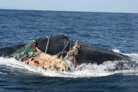

16 Threats to whales Entanglements Ship strikes Sound 16


17 Blue whale tracks 171 tags deployed during by Bruce Mate and his team at OSU Most of the whales tagged off California in July-October Tracking duration ranged from <1 day to 504 days 17
18 Northeast Pacific Blue Whales Bailey et al Endangered Species Res. 18
19 Analysis Process 1. Reduce 2. Reconstitute 3. Predict Turning angle Speed Foraging Migrating 19


20 State-space modeling A time series model that predicts the future state of a system from its previous states probabilistically (Patterson et al TREE) 20
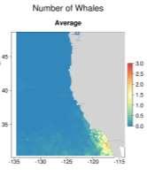
21 State-space movement model Measurement equation Probability of obtaining observation, conditional on animal s true location. Transition equation Predicts the future location, given its current location. Mean turning angle d t d t-1 Autocorrelation in speed and direction Transiting Foraging From Vincent et al. (2002) From Jonsen et al. (2007) 21

22 High-use areas ARS=Area-restricted search, indicates foraging or breeding behavior Bailey et al Endangered Species Res. 22

23 Bailey et al Endangered Species Res. 23
 Bailey et al. 2009 Endangered Species Res.")
24 Patch spatial scale First passage time radius (km) Bailey et al Endangered Species Res. 24

25 Seasonal pattern 25


26 Blue whale habitat-based model State-Space Modeled Whale Positions Legend SSM Tracks Sim CRW Simulate Correlated Random Walk Tracks Examine Environmental Characteristics TelemetryBased Habitat Model Near Real-Time Predictions of Occurrence and Densities ,200 2,400 km Survey Data for Validation 26

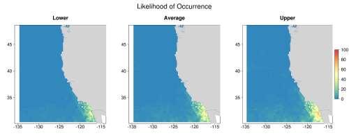
27 Predictions of occurrence March 2009 July 2009 Sept 2009 Dec 2009 Hazen et al. In press J. App. Ecol. 27

28 Predictions for 2009 Number of blue whales per 25 x 25 km grid cell 28 Hazen et al. In press J. Appl. Ecol.
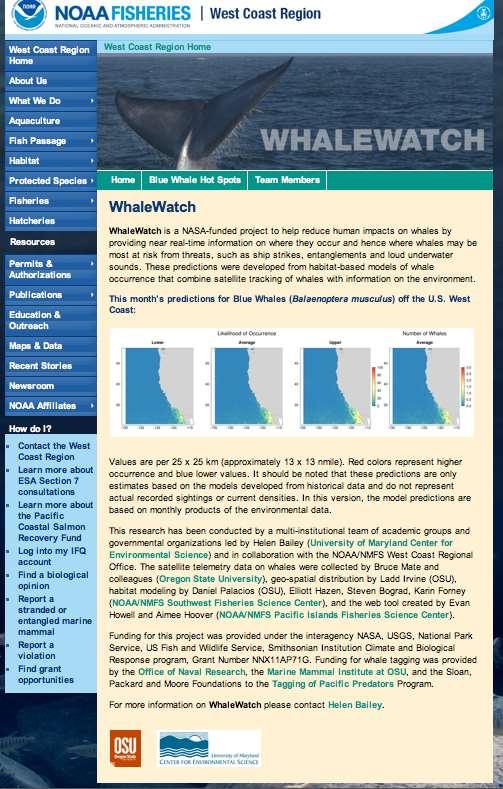

29 Prediction tool Website: lewatch 29


30 September Prediction Higher use by blue whales in busy shipping area predicted in 2009 than

31 Dynamic Ocean Management Dynamic ocean management (DOM): Management that changes in space and time in response to the shifting nature of the ocean and its users based on the integration of current biological, oceanographic, social, and/or economic data. Hobday et al. 2014, Lewison et al and Maxwell et al


32 Acoustic telemetry Tag Receiver Tag animal with individually coded transmitters Mobile tracking: Use a hydrophone to follow tagged animals. Fixed receivers: Continuously monitor for transmitters at known locations. Advantages: Smaller than satellite tag and transmits underwater. Disadvantages: Receivers mainly used in shallow coastal environments. Detections only at pre-defined receiver locations. 32
, n=40 Ocean contingent (OC), n=20 Tracking duration up to 816 days Tagging by David Secor, Tagging video CBL")
33 Tagging striped bass 75 striped bass tagged with acoustic transmitters in October 2009 and May Upper estuary contingent (UEC), n=15. Lower estuary contingent (LEC), n=40 Ocean contingent (OC), n=20 Tracking duration up to 816 days Tagging by David Secor, Tagging video CBL UMCES 33

34 Acoustic detections Track data: David Secor, CBL UMCES 34

35 Acoustic detections >550,000 detections! From Gahagan et al

36 40.9 N 18 May N 40.7 N 9 Aug N 19 May Oct N Movements of an individual fish, ID 11 36

37 Extreme weather events Extreme events likely to increase in intensity and frequency with climate change Difficult to design and implement ecological studies for these rare, unpredictable events. Reconstruct movements from acoustic telemetry Striped bass 37
38 Tropical Storms 2011 Water level and temperature data from USGS daily statistics at the south dock at West Point, NY, and salinity and DO from HRECOS GWB station. 38
 with the track section nested within the individual (n=22) as a random effect.")
39 Approach Before-during-after-control-impact design Before=13-27 Aug, During=28 Aug-11 Sep, After=12-26 Sep, Control=2010, Impact=2011 Response= Mean daily latitude for each fish Fit generalized linear mixed model (GLMM) with the track section nested within the individual (n=22) as a random effect. 39
40 Fish ID 3 (UEC) Average speed 0.02 m/s (0.04 BL/s) 0.70 m/s (1.45 BL/s) ID 3 total length 483 mm (mean UEC tagged 490 mm) 40
41 Response to storm events Bailey and Secor 2016 Scientific Reports Significant interaction between the time period (before-duringafter) and year (2010 control, 2011 impact). More pronounced southward movement after the storms suggesting they caused a coastal evacuation of striped bass. 41

42 Residency in NY Harbor Bailey and Secor 2016 Scientific Reports Significant interaction between month of October and the year, with less time spent in NY Harbor in October 2011, after the storms, than in

43 Resident behavior Fish ID 16 (LEC) remained in NY Harbor from 4 June 2011 to 5 November 2011 (last reported detection). During the period of the storms it was regularly detected near Liberty Island and Governors 43 Island. Total length 590 mm (mean LEC tagged 607 mm).
 and then entered NY Harbor on 29 Oct 2011 and swam upriver.")
44 Exploratory behavior Fish ID 5 (UEC) returned to NY Harbor on 22 Oct 2011, moved out to the coast (off NJ Sandy Hook Oct) and then entered NY Harbor on 29 Oct 2011 and swam upriver. 44
45 White perch Data from Applied Science Associates Year Class Report 45
46 Next steps Developing striped bass habitat model by identifying environmental associations Coastal habitat use of striped bass (Hudson River Foundation award, co-pi with Dave Secor). Movements, habitat use and behavior of tagged fish in the Maryland Wind Energy Area (BOEM award, co-pi with Dave Secor) 46

47 Future work DATA DELUGE! Analysis techniques catching up with the abundance of telemetry data becoming available. Opportunities to study fine-scale movements, habitat use and behavior of fish using acoustic telemetry (VEMCO Positioning System) 47

48 Acknowledgements Funding for the whale study was funded by NOAA and NASA. Thank you to the Hudson River Foundation for supporting the striped bass project. 48
Near-Field Sturgeon Monitoring for the New NY Bridge at Tappan Zee. Quarterly Report October 1 December 31, 2014
 Near-Field Sturgeon Monitoring for the New NY Bridge at Tappan Zee Quarterly Report October 1 December 31, 2014 Prepared by AKRF, Inc. 7250 Parkway Drive, Suite 210 Hanover, MD 21076 for New York State
Fine-scale Survey of Right and Humpback Whale Prey Abundance and Distribution
 DISTRIBUTION STATEMENT A: Approved for public release; distribution is unlimited. Fine-scale Survey of Right and Humpback Whale Prey Abundance and Distribution Joseph D. Warren School of Marine and Atmospheric
R. Michael Laurs 1, David G. Foley 2, and Michael Musyl 2. RML Fisheries Oceanographer Consultant, LLC, Jacksonville, OR USA
 Update on Research Regarding Identification and Utilization Of Habitats by Large Pacific Sharks Using PSAT Archival Tags, Oceanic Satellite Remote Sensing, and SODA Ocean Assimilation Model Analyses R.
Climate Change and Baleen Whale Trophic Cascades in Greenland
 Climate Change and Baleen Whale Trophic Cascades in Greenland Kristin L. Laidre Polar Science Center, Applied Physics Laboratory, University of Washington, 1013 NE 40th St. Seattle, WA 98105 USA phone:
Blue and Fin Whale Habitat Modeling from Long-Term Year-Round Passive Acoustic Data from the Southern California Bight
 DISTRIBUTION STATEMENT A. Approved for public release; distribution is unlimited. Blue and Fin Whale Habitat Modeling from Long-Term Year-Round Passive Acoustic Data from the Southern California Bight
Real-time monitoring of right whales using autonomous underwater vehicles
 Real-time monitoring of right whales using autonomous underwater vehicles Dr. Kimberley Davies 1, Dr. Mark Baumgartner 2, Delphine Durette Morin 1, Hansen Johnson 1,2, Dr. Christopher Taggart 1 1. Department
Appendix K Gulf Sturgeon Telemetry Survey Presentation
 Appendix K Gulf Sturgeon Telemetry Survey Presentation Summary of Gulf Sturgeon monitoring activities on Ship Island: 2012-2013 deployment period. William T. Slack ERDC Mark S. Peterson USM-Gulf Coast
Acoustic monitoring finding new populations of the endangered blue whale
 Acoustic monitoring finding new populations of the endangered blue whale Tracey Rogers, Gary Truong, Joy Tripovich, Naysa Balcazar Blue whale (Balaenoptera musculus) Largest baleen whale Critically endangered
Climate change and baleen whale trophic cascades in Greenland
 Climate change and baleen whale trophic cascades in Greenland Kristin L. Laidre Polar Science Center, Applied Physics Laboratory, University of Washington, 1013 NE 40th St. Seattle, WA 98105 USA Phone:
Name Period Part I: INVESTIGATING OCEAN CURRENTS: PLOTTING BUOY DATA
 Name Period Part I: INVESTIGATING OCEAN CURRENTS: PLOTTING BUOY DATA INTRODUCTION: Ocean currents are like huge rivers in the sea. They carry drifting organisms, vital dissolved chemical nutrients and
Chiang Rai Province CC Threat overview AAS1109 Mekong ARCC
 Chiang Rai Province CC Threat overview AAS1109 Mekong ARCC This threat overview relies on projections of future climate change in the Mekong Basin for the period 2045-2069 compared to a baseline of 1980-2005.
I. Objectives Describe vertical profiles of pressure in the atmosphere and ocean. Compare and contrast them.
 ERTH 430: Lab #1: The Vertical Dr. Dave Dempsey Fluid Dynamics Pressure Gradient Force/Mass Earth & Clim. Sci. in Earth Systems SFSU, Fall 2016 (Tuesday, Oct. 25; 5 pts) I. Objectives Describe vertical
Satellite-derived environmental drivers for top predator hotspots
 Satellite-derived environmental drivers for top predator hotspots Peter Miller @PeterM654 South West Marine Ecosystems 2017 21 Apr. 2017, Plymouth University Satellite environmental drivers for hotspots
UPDATE OF REGIONAL WEATHER AND SMOKE HAZE (December 2017)
") UPDATE OF REGIONAL WEATHER AND SMOKE HAZE (December 2017) 1. Review of Regional Weather Conditions for November 2017 1.1 In November 2017, Southeast Asia experienced inter-monsoon conditions in the first
UPDATE OF REGIONAL WEATHER AND SMOKE HAZE (December 2017) 1. Review of Regional Weather Conditions for November 2017 1.1 In November 2017, Southeast Asia experienced inter-monsoon conditions in the first
Three main areas of work:
 Task 2: Climate Information 1 Task 2: Climate Information Three main areas of work: Collect historical and projected weather and climate data Conduct storm surge and wave modeling, sea-level rise (SLR)
8.1 Attachment 1: Ambient Weather Conditions at Jervoise Bay, Cockburn Sound
 8.1 Attachment 1: Ambient Weather Conditions at Jervoise Bay, Cockburn Sound Cockburn Sound is 20km south of the Perth-Fremantle area and has two features that are unique along Perth s metropolitan coast
Talk Overview. Concepts. Climatology. Monitoring. Applications
 Atmospheric Rivers Talk Overview Concepts Climatology Monitoring Applications Satellite View Where is the storm? Where is the impact? Atmospheric Rivers Plume or fire hose of tropical moisture Heavy precipitation
Geovisualization of shipping noise exposure for whales in Canada. Simone Cominelli; Brent Hall; Michael Leahy; Michael Luubert
 Geovisualization of shipping noise exposure for whales in Canada Simone Cominelli; Brent Hall; Michael Leahy; Michael Luubert Introduction ANTHROPOGENIC NOISE, SHIPPING AND CETACEANS ANTHROPOGENIC NOISE
The DEPONS project Disturbance Effects on the Harbour Porpoise Population in the North Sea
 The DEPONS project Disturbance Effects on the Harbour Porpoise Population in the North Sea Jacob Nabe-Nielsen, Aarhus University ASCOBANS meeting Wilhelmshaven, 20 June 2017 Modelling cumulative effects
Ocean Currents Student Activity Book
 Ocean Currents Student Activity Book I. Introduction Ocean currents influence the weather in coastal areas. They also influence sailing vessels. Though they visibly affect many people's lives, they are
ESP Process Flow. 2/27/2012 Environmental Studies Program 1
 ESP Process Flow 2/27/2012 Environmental Studies Program 1 Studies Management Process Timeline Oct Nov Dec Jan Feb Mar Apr May Jun Jul Aug SDP Guidance Stakeholder Input Due SDP Preparation Draft SDPs
Distributional changes of west coast species and impacts of climate change on species and species groups
 Distributional changes of west coast species and impacts of climate change on species and species groups Elliott Hazen 1 Ole Shelton 2 Eric Ward 2 1 NOAA Southwest Fisheries Science Center 2 NOAA Northwest
The known requirements for Arctic climate services
 The known requirements for Arctic climate services based on findings described in STT White paper 8/2015 Johanna Ekman / EC PHORS STT Regional drivers The Arctic region is home to almost four million people
Coastal Ocean Circulation Experiment off Senegal (COCES)
") DISTRIBUTION STATEMENT A. Approved for public release; distribution is unlimited. Coastal Ocean Circulation Experiment off Senegal (COCES) Pierre-Marie Poulain Istituto Nazionale di Oceanografia e di Geofisica
DISTRIBUTION STATEMENT A. Approved for public release; distribution is unlimited. Coastal Ocean Circulation Experiment off Senegal (COCES) Pierre-Marie Poulain Istituto Nazionale di Oceanografia e di Geofisica
How typical are current conditions?
 How typical are current conditions? NANOOS provides many sources of information for those wanting to track oceanographic conditions throughout the NE Pacific Ocean to be able to understand if the current
Integrating climate forecasting tools into predictive models of marine mammal distribution
 Integrating climate forecasting tools into predictive models of marine mammal distribution Elizabeth Becker 1, Dave Foley 1, 2, Karin Forney 1, Jay Barlow 1 1 NOAA Fisheries, Southwest Fisheries Science
Grant Opportunity Monitoring Bi-State Sage-grouse Populations in Nevada
 Grant Opportunity Monitoring Bi-State Sage-grouse Populations in Nevada Proposals are due no later than November 13, 2015. Grant proposal and any questions should be directed to: Shawn Espinosa @ sepsinosa@ndow.org.
BOEM Marine Minerals Program
 BOEM Marine Minerals Program Restoring and Protecting Our Nation s Coasts through Stewardship of OCS Sand Resources SECOORA 2018 Annual Meeting May 22-24 Doug Piatkowski Douglas.piatkowski@boem.gov 703-787-1833
New NASA Ocean Observations and Coastal Applications
 New NASA Ocean Observations and Coastal Applications Duane Armstrong Chief, Applied Science & Technology Project Office August 20, 2014 1 Outline NASA s new Earth Science Ocean Science Missions for 2014
Outline. Building Delphinid Habitat Models with Passive Acoustic Monitoring Data. Study Area. Species. HARP Data Analysis. Instrumentation 10/23/09
 Outline Building Delphinid Habitat Models with Passive Acoustic Monitoring Data Data Collection Model Challenges True absence vs. false absence Data sampling differences Temporal scale of datasets Case
Seasonal forecasting as a stepping stone to climate adaptation in marine fisheries and aquaculture
 Seasonal forecasting as a stepping stone to climate adaptation in marine fisheries and aquaculture Alistair Hobday Paige Eveson Jason Hartog Claire Spillman Projected changes (e.g. distribution) 11 species
Possible Applications of Deep Neural Networks in Climate and Weather. David M. Hall Assistant Research Professor Dept. Computer Science, CU Boulder
 Possible Applications of Deep Neural Networks in Climate and Weather David M. Hall Assistant Research Professor Dept. Computer Science, CU Boulder Quick overview of climate and weather models Weather models
Spatio-temporal dynamics of Marbled Murrelet hotspots during nesting in nearshore waters along the Washington to California coast
 Western Washington University Western CEDAR Salish Sea Ecosystem Conference 2014 Salish Sea Ecosystem Conference (Seattle, Wash.) May 1st, 10:30 AM - 12:00 PM Spatio-temporal dynamics of Marbled Murrelet
Hurricane Floyd Symposium. Satellite Precipitation as a Tool to Reanalyze Hurricane Floyd and Forecast Probabilities of Extreme Rainfall
 Sept. 18, 2009 Hurricane Floyd Symposium Scott Curtis, East Carolina Universtiy Satellite Precipitation as a Tool to Reanalyze Hurricane Floyd and Forecast Probabilities of Extreme Rainfall What was the
UPDATE OF REGIONAL WEATHER AND SMOKE HAZE (September 2017)
") UPDATE OF REGIONAL WEATHER AND SMOKE HAZE (September 2017) 1. Review of Regional Weather Conditions in August 2017 1.1 Southwest Monsoon conditions continued to prevail in the region in August 2017. The
UPDATE OF REGIONAL WEATHER AND SMOKE HAZE (September 2017) 1. Review of Regional Weather Conditions in August 2017 1.1 Southwest Monsoon conditions continued to prevail in the region in August 2017. The
Climate Change and Baleen Whale Trophic Cascades in Greenland
 Climate Change and Baleen Whale Trophic Cascades in Greenland Kristin L. Laidre Polar Science Center, Applied Physics Laboratory, University of Washington, 1013 NE 40th St. Seattle, WA 98105 USA phone:
Government of Sultanate of Oman Public Authority of Civil Aviation Directorate General of Meteorology. National Report To
 Government of Sultanate of Oman Public Authority of Civil Aviation Directorate General of Meteorology National Report To Panel on Tropical Cyclones in the Bay of Bengal And Arabian Sea 43rd Session, India
The MSC Beaufort Wind and Wave Reanalysis
 The MSC Beaufort Wind and Wave Reanalysis Val Swail Environment Canada Vincent Cardone, Brian Callahan, Mike Ferguson, Dan Gummer and Andrew Cox Oceanweather Inc. Cos Cob, CT, USA Introduction: History
The Coupled Earth Reanalysis system [CERA]
![The Coupled Earth Reanalysis system [CERA]](/thumbs/95/122770734.jpg "The Coupled Earth Reanalysis system [CERA]") The Coupled Earth Reanalysis system [CERA] Patrick Laloyaux Acknowledgments: Eric de Boisséson, Magdalena Balmaseda, Dick Dee, Peter Janssen, Kristian Mogensen, Jean-Noël Thépaut and Reanalysis Section
The Coupled Earth Reanalysis system [CERA] Patrick Laloyaux Acknowledgments: Eric de Boisséson, Magdalena Balmaseda, Dick Dee, Peter Janssen, Kristian Mogensen, Jean-Noël Thépaut and Reanalysis Section
NOAA S Arctic Program in 2017
 NOAA S Arctic Program in 2017 NOAA s Arctic Mission To determine how the Arctic system is changing on time scales of weeks to decades, particularly with respect to the consequences that the loss of sea
Real World Globes Investigating Surface Currents around the Globe Authored by Ryan Glaubke, Graduate Student at Old Dominion University, Norfolk, VA
 Real World Globes Investigating Surface Currents around the Globe Authored by Ryan Glaubke, Graduate Student at Old Dominion University, Norfolk, VA Purpose: - To practice basic plotting techniques using
The ECMWF coupled data assimilation system
 The ECMWF coupled data assimilation system Patrick Laloyaux Acknowledgments: Magdalena Balmaseda, Kristian Mogensen, Peter Janssen, Dick Dee August 21, 214 Patrick Laloyaux (ECMWF) CERA August 21, 214
DBCP 2012 SCIENTIFIC AND TECHNICAL WORKSHOP Fremantle, Australia, 2 October 2012 SALIENT FEATURES OF INDIAN DEEP SEA INSTRUMENTED BUOY NETWORK IN THE
 DBCP 2012 SCIENTIFIC AND TECHNICAL WORKSHOP Fremantle, Australia, 2 October 2012 SALIENT FEATURES OF INDIAN DEEP SEA INSTRUMENTED BUOY NETWORK IN THE BAY OF BENGAL R. Venkatesan, Arul Muthiah, Simi Mathew
Northwest Outlook October 2016
 Northwest Outlook October 2016 Rainfall Opportunities and Challenges Rainfall over the month of September presented some challenges for the fall harvest while other producers benefitted. Figure 1a shows
HAB Forecaster. For info on HABs in the Pacific Northwest see:
 HAB Forecaster BACKGROUND In this activity, students can take on the role as a resource manager or scientist, tasked with deciding if razor clam harvesters should go out onto the beach to harvest razor
Earth Science Lesson Plan Quarter 2, Week 10, Day 1
 Earth Science Lesson Plan Quarter 2, Week 10, Day 1 Outcomes for Today Standard Focus: PREPARE 1. Background knowledge necessary for today s reading. Beaches are created by the actions of waves, tides,
Behavioral Ecology of Narwhals in a Changing Arctic
 DISTRIBUTION STATEMENT A. Approved for public release; distribution is unlimited. Behavioral Ecology of Narwhals in a Changing Arctic Kristin L. Laidre and Harry Stern Polar Science Center Applied Physics
How and why is the timing and occurrence of seasonal migrants in the Gulf of Maine changing due to climate?
 How and why is the timing and occurrence of seasonal migrants in the Gulf of Maine changing due to climate? Dan Pendleton, ACCOL @ the New England Aquarium with PIs Michelle Staudinger & Adrian Jordaan
Satellites, Weather and Climate Module??: Polar Vortex
 Satellites, Weather and Climate Module??: Polar Vortex SWAC Jan 2014 AKA Circumpolar Vortex Science or Hype? Will there be one this year? Today s objectives Pre and Post exams What is the Polar Vortex
National Marine Sanctuary Program
 National Marine Sanctuary Program NMSP/USGS Joint Seabed Mapping Initiative: September 2004 AA National Ocean Service National Marine Sanctuaries Interim Report September 2004 Background: Since 2002,
Climate. Annual Temperature (Last 30 Years) January Temperature. July Temperature. Average Precipitation (Last 30 Years)
 January Temperature. July Temperature. Average Precipitation (Last 30 Years)") Climate Annual Temperature (Last 30 Years) Average Annual High Temp. (F)70, (C)21 Average Annual Low Temp. (F)43, (C)6 January Temperature Average January High Temp. (F)48, (C)9 Average January Low Temp.
Climate Annual Temperature (Last 30 Years) Average Annual High Temp. (F)70, (C)21 Average Annual Low Temp. (F)43, (C)6 January Temperature Average January High Temp. (F)48, (C)9 Average January Low Temp.
Eyes in the sky: linking satellite oceanography and biotelemetry to explore habitat selection by basking sharks
 Eyes in the sky: linking satellite oceanography and biotelemetry to explore habitat selection by basking sharks Curtis et al. Curtis et al. Animal Biotelemetry 2014, 2:12 Curtis et al. Animal Biotelemetry
Rainfall Observations in the Loxahatchee River Watershed
 Rainfall Observations in the Loxahatchee River Watershed Richard C. Dent Loxahatchee River District September 1997 Introduction Rain is a common occurrence in south Florida, yet its presence or absence
Sharks and Tropical Weather
 Target Audience: Middle - High School (8-12) Sharks and Tropical Weather Resources: Research data based on Running before the Storm: blacktip sharks respond to falling barometric pressure associated with
It s true, these activities are all facets of marine science. But they represent a pretty small part of the picture.
 Welcome. Thanks for coming to CBNERR s Discovery Lab. I m Lisa Lawrence and I m a marine educator at VIMS. Tonight, I m going to give you just glimpse of what it s like to be a marine scientist and tell
Enhancing Weather Information with Probability Forecasts. An Information Statement of the American Meteorological Society
 Enhancing Weather Information with Probability Forecasts An Information Statement of the American Meteorological Society (Adopted by AMS Council on 12 May 2008) Bull. Amer. Meteor. Soc., 89 Summary This
Homework 9: Hurricane Forecasts (adapted from Pipkin et al.)
") November 2010 MAR 110 HW9 Hurricane Forecasts 1 Homework 9: Hurricane Forecasts (adapted from Pipkin et al.) Movement of Hurricanes The advance of a tropical storm or hurricane is controlled by the prevailing
November 2010 MAR 110 HW9 Hurricane Forecasts 1 Homework 9: Hurricane Forecasts (adapted from Pipkin et al.) Movement of Hurricanes The advance of a tropical storm or hurricane is controlled by the prevailing
Putative Canada Lynx (Lynx canadensis) Movements across I-70 in Colorado
 Movements across I-70 in Colorado") Putative Canada Lynx (Lynx canadensis) Movements across I-70 in Colorado INTRODUCTION March 8, 2012 Jake Ivan, Mammals Researcher Colorado Parks and Wildlife 317 W. Prospect Fort Collins, CO 80526 970-472-4310
Putative Canada Lynx (Lynx canadensis) Movements across I-70 in Colorado INTRODUCTION March 8, 2012 Jake Ivan, Mammals Researcher Colorado Parks and Wildlife 317 W. Prospect Fort Collins, CO 80526 970-472-4310
Introduction to Part III Examining wildlife distributions and abundance using boat surveys
 Baseline Wildlife Studies in Atlantic Waters Offshore of Maryland: Final Report to the Maryland Department of Natural Resources and Maryland Energy Administration, 2015 Introduction to Part III Examining
Northeast U.S. Early Season Preview 2017 FISHING ACTION STARTING TO WARM UP ALREADY WITH LOTS OF FISH EXPECTED IN MAY
 Northeast U.S. Early Season Preview 2017 FISHING ACTION STARTING TO WARM UP ALREADY WITH LOTS OF FISH EXPECTED IN MAY By Matthew A. Upton and Mitchell A. Roffer ROFFS concludes its 2017 spring preview
STAMP Spa)al Tools for Arc)c Mapping & Planning. Creating an interactive data tool to improve access and usability of Arctic data
al Tools for Arc)c Mapping & Planning. Creating an interactive data tool to improve access and usability of Arctic data") STAMP Spa)al Tools for Arc)c Mapping & Planning Creating an interactive data tool to improve access and usability of Arctic data Mission Provide easy access to physical, chemical, and biological data Network
STAMP Spa)al Tools for Arc)c Mapping & Planning Creating an interactive data tool to improve access and usability of Arctic data Mission Provide easy access to physical, chemical, and biological data Network
Identification of Large Pelagic Shark Habitats in the Central North Pacific Using PSATs, Satellite Remote Sensing, and SODA Assimilation Ocean Models
 Identification of Large Pelagic Shark Habitats in the Central North Pacific Using PSATs, Satellite Remote Sensing, and SODA Assimilation Ocean Models R. Michael Laurs 1, David G. Foley 2, and Michael Musyl
Guided Notes Weather. Part 2: Meteorology Air Masses Fronts Weather Maps Storms Storm Preparation
 Guided Notes Weather Part 2: Meteorology Air Masses Fronts Weather Maps Storms Storm Preparation The map below shows North America and its surrounding bodies of water. Country borders are shown. On the
Using GIS and Remote Sensing to Manage North Atlantic Right Whale Populations Eleni Gesch-Karamanlidis
 Using GIS and Remote Sensing to Manage North Atlantic Right Whale Populations Eleni Gesch-Karamanlidis Northern Right whales remain one of the most endangered mammals in the ocean (Ward-Geiger et al 2005,
Habitat Suitability for Forage Fishes in Chesapeake Bay
 Habitat Suitability for Forage Fishes in Chesapeake Bay Aug 2017 Jul 2019 Mary C Fabrizio Troy D Tuckey Aaron J Bever Michael L MacWilliams 21 June 2018 Photo: Chesapeake Bay Program Motivation Production
Supplementary appendix
 Supplementary appendix This appendix formed part of the original submission and has been peer reviewed. We post it as supplied by the authors. Supplement to: Lowe R, Stewart-Ibarra AM, Petrova D, et al.
Climate Change and Baleen Whale Trophic Cascades in Greenland
 DISTRIBUTION STATEMENT A: Approved for public release; distribution is unlimited. Climate Change and Baleen Whale Trophic Cascades in Greenland Kristin L. Laidre Polar Science Center Applied Physics Laboratory
Met Office and UK University contribution to YMC Ground instrumentation and modelling
 Met Office and UK University contribution to YMC Ground instrumentation and modelling Cathryn Birch 1,2 Adrian Matthews 3, Steve Woolnough 4, John Marsham 2, Douglas Parker 2, Paul Barret 1, Prince Xavier
Hurricane Lane. Hawaiian Islands, August By Ian Robertson 1, Ph.D., P.E.
 Hurricane Lane Hawaiian Islands, August 2018 By Ian Robertson 1, Ph.D., P.E. Hurricane Lane, a major Pacific Ocean hurricane, narrowly missed making landfall on the main Hawaiian Islands, but still caused
Relatively little hard substrate occurs naturally in the
 CHAPTER FIVE Rock Habitats Relatively little hard substrate occurs naturally in the estuary, owing mainly to the vast quantities of fine sediment that have been deposited by the rivers. Rock habitat is
Tracking Hurricane Sandy
 Name: Date: Tracking Hurricane Sandy Purpose: The purpose of this lab is to use data collected during Hurricane Sandy to track the movement of its low-pressure center. The student will also answer questions
Behavioral Ecology of Narwhals in a Changing Arctic
 DISTRIBUTION STATEMENT A. Approved for public release; distribution is unlimited. Behavioral Ecology of Narwhals in a Changing Arctic Kristin L. Laidre & Harry Stern Polar Science Center Applied Physics
Weather Analysis and Forecasting
 Weather Analysis and Forecasting An Information Statement of the American Meteorological Society (Adopted by AMS Council on 25 March 2015) Bull. Amer. Meteor. Soc., 88 This Information Statement describes
On the presence of tropical vortices over the Southeast Asian Sea- Maritime Continent region
 Technical Conference of 50 th Annual Session of Typhoon Committee 2018 On the presence of tropical vortices over the Southeast Asian Sea- Maritime Continent region Nguyen Dang-Quang 1, James Renwick 2,
"STUDY ON THE VARIABILITY OF SOUTHWEST MONSOON RAINFALL AND TROPICAL CYCLONES FOR "
 "STUDY ON THE VARIABILITY OF SOUTHWEST MONSOON RAINFALL AND TROPICAL CYCLONES FOR 2001 2010" ESPERANZA O. CAYANAN, Ph.D. Chief, Climatology & Agrometeorology R & D Section Philippine Atmospheric Geophysical
Setting Priorities for Eelgrass Conservation and Restoration. Robert Buchsbaum Massachusetts Audubon Society
 Setting Priorities for Eelgrass Conservation and Restoration Robert Buchsbaum Massachusetts Audubon Society Eelgrass habitat values A rich, productive habitat for many marine organisms Nursery habitat
UPDATE OF REGIONAL WEATHER AND SMOKE HAZE (February 2018)
") UPDATE OF REGIONAL WEATHER AND SMOKE HAZE (February 2018) 1. Review of Regional Weather Conditions for January 2018 1.1 The prevailing Northeast monsoon conditions over Southeast Asia strengthened in January
UPDATE OF REGIONAL WEATHER AND SMOKE HAZE (February 2018) 1. Review of Regional Weather Conditions for January 2018 1.1 The prevailing Northeast monsoon conditions over Southeast Asia strengthened in January
Climate Change Impacts on the Marine Environment
 Climate Change Impacts on the Marine Environment Ken Ridgway CSIRO Marine and Atmospheric Research Wealth from Oceans National Research Flagship www.csiro.au Acknowledgements Jeff Dunn, John Church, Katy
Long-term Water Quality Monitoring in Estero Bay
 Long-term Water Quality Monitoring in Estero Bay Keith Kibbey Laboratory Director Lee County Environmental Laboratory Division of Natural Resource Management Estero Bay Monitoring Programs Three significant
Evaluating Physical, Chemical, and Biological Impacts from the Savannah Harbor Expansion Project Cooperative Agreement Number W912HZ
 Evaluating Physical, Chemical, and Biological Impacts from the Savannah Harbor Expansion Project Cooperative Agreement Number W912HZ-13-2-0013 FY 2016 - First Quarterly Report January 1, 2016 Submitted
West Florida Shelf and Tampa Bay Responses to Hurricane Irma: What Happened and Why
 West Florida Shelf and Tampa Bay Responses to Hurricane Irma: What Happened and Why R.H. Weisberg Y. Liu J. Chen College of Marine Science University of South Florida St. Petersburg, FL SECOORA Webinar
The Delaware Environmental Monitoring & Analysis Center
 The Delaware Environmental Monitoring & Analysis Center Tina Callahan Delaware Estuary Science & Environmental Summit 2013 January 27-30, 2013 What is DEMAC? Delaware Environmental Monitoring & Analysis
1-2. Level. Author JoBea Holt. Ph.D.
 1-2 Level Author JoBea Holt. Ph.D. Table of Contents Introduction Research and Introduction....... 4 Overview of Google Earth........ 6 How to Use This Book........... 8 Google Earth Reference Window..
Background Field program information Examples of measurements Wind validation for synthetic modeling effort
 Background Field program information Examples of measurements Wind validation for synthetic modeling effort How do complex fine-scale structure and processes in coastal waters dominated by pulsed-river
Weather and Climate of the Rogue Valley By Gregory V. Jones, Ph.D., Southern Oregon University
 Weather and Climate of the Rogue Valley By Gregory V. Jones, Ph.D., Southern Oregon University The Rogue Valley region is one of many intermountain valley areas along the west coast of the United States.
Third Grade Math and Science DBQ Weather and Climate/Representing and Interpreting Charts and Data - Teacher s Guide
 Third Grade Math and Science DBQ Weather and Climate/Representing and Interpreting Charts and Data - Teacher s Guide A document based question (DBQ) is an authentic assessment where students interact with
Lesson 3: Tracking the Gentle Giants Student Version. Lesson Objectives: At the end of the lesson, students will be able to
 Student Version Lesson Objectives: At the end of the lesson, students will be able to Use basic GeoMapApp skills and mapping software functionality to explore real world scientific data sets collected
Tracking the Salt Front
 Tracking the Salt Front Students will use Hudson River salinity data to practice math skills as they track movements of the salt front in response to storms and other weather events. Objectives: Students
OCEANOGRAPHIC DATA MANAGEMENT
 OCEANOGRAPHIC DATA MANAGEMENT Presented to: Environmental Disaster Data Management Meeting Russ Beard Director, National Coastal Data Development Center Interim Science Coordinator, Gulf Restoration Council
Climate Change Impacts in Alaska: the Weather Perspective
 Climate Change Impacts in Alaska: the Weather Perspective September 18, 2007 NOAA s National Weather Service, Alaska Region James Partain, Chief Environmental and Scientific Services Division NOAA NWS
Blue and Fin Whale Habitat Modeling from Long-Term Year-Round Passive Acoustic Data from the Southern California Bight
 DISTRIBUTION STATEMENT A. Approved for public release; distribution is unlimited. Blue and Fin Whale Habitat Modeling from Long-Term Year-Round Passive Acoustic Data from the Southern California Bight
Antarctic Automatic Weather Station Data for the calendar year 2000
 Antarctic Automatic Weather Station Data for the calendar year 2000 by Linda M. Keller George A. Weidner Charles R. Stearns Matthew T. Whittaker Robert E. Holmes Matthew A. Lazzara Space Science and Engineering
Chapter 8. Biogeographic Processes. Upon completion of this chapter the student will be able to:
 Chapter 8 Biogeographic Processes Chapter Objectives Upon completion of this chapter the student will be able to: 1. Define the terms ecosystem, habitat, ecological niche, and community. 2. Outline how
A Preliminary Home-Range Analysis of Loggerhead Sea Turtles Released in Virginia & North Carolina
 A Preliminary Home-Range Analysis of Loggerhead Sea Turtles Released in Virginia & North Carolina Gwen G. Lockhart GIS Research Specialist Virginia Aquarium & Marine Science Center & Susan G. Barco Research
ARUBA CLIMATOLOGICAL SUMMARY 2017 PRECIPITATION
 ARUBA CLIMATOLOGICAL SUMMARY 2017 PRECIPITATION The total amount of rainfall recorded at Reina Beatrix International Airport for the year 2017 was 391.0 mm. This is 17.1 % below normal ( Figure 1 ). During
Groundwater dynamics and surface water-groundwater interaction in a prograding delta island, Louisiana, USA
 Supplementary Information Groundwater dynamics and surface water-groundwater interaction in a prograding delta island, Louisiana, USA Michael T. O Connor 1* and Kevan B. Moffett 1,2 1 Department of Geological
Observed Climate Variability and Change: Evidence and Issues Related to Uncertainty
 Observed Climate Variability and Change: Evidence and Issues Related to Uncertainty David R. Easterling National Climatic Data Center Asheville, North Carolina Overview Some examples of observed climate
9/56 YEAR CYCLE: HURRICANES
 New Concepts in Global Tectonics Newsletter, no., June, 20 / YEAR CYCLE: HURRICANES David McMINN Independent cycle researcher Mcminn@yahoo.com Twin Palms, Blue Knob, NSW 280, Australia Abstract: The timing
Produced by Canadian Ice Service of. 2 December Seasonal Outlook Gulf of St Lawrence and East Newfoundland Waters Winter
 Environment Canada Environnement Canada Produced by Canadian Ice Service of Environment Canada 2 December 2010 Seasonal Outlook Gulf of St Lawrence and East Newfoundland Waters Winter 2010-2011 2010 Canadian
ESCI 1010 Lab 7 Hurricanes (AKA: Typhoons, Cyclones)
") ESCI 1010 Lab 7 Hurricanes (AKA: Typhoons, Cyclones) Before Lab: Review pages 328-361 in your Weather and Climate textbook. Please pay special attention to the sections entitled: Hurricanes around the
ESCI 1010 Lab 7 Hurricanes (AKA: Typhoons, Cyclones) Before Lab: Review pages 328-361 in your Weather and Climate textbook. Please pay special attention to the sections entitled: Hurricanes around the