A Preliminary Home-Range Analysis of Loggerhead Sea Turtles Released in Virginia & North Carolina
|
|
|
- Ashlyn McKenzie
- 5 years ago
- Views:
Transcription
 Activities conducted under NMFS Research")
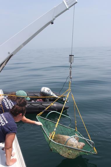
1 A Preliminary Home-Range Analysis of Loggerhead Sea Turtles Released in Virginia & North Carolina Gwen G. Lockhart GIS Research Specialist Virginia Aquarium & Marine Science Center & Susan G. Barco Research Coordinator Virginia Aquarium & Marine Science Center 2 nd Southeast Regional Sea Turtle Meeting February 4-7, 2015 on Jekyll Island, GA (USA) Activities conducted under NMFS Research Permit No


2 Acknowledgements NMFS Species Recovery Grants to State Virginia Aquarium Staff and Volunteers SeaTurtle.org Movebank.org
")
3 Primary Study Area Virginia Virginia coastal and estuarine waters are an important foraging habitat for juvenile loggerhead (Caretta caretta) sea turtle (Musick and Limpus 1997; Mansfield et al. 2009; Shoop and Kenney 1992; Epperly et al. 1995; Keinath 1993; Keinath et al. 1996; Mansfield 2006; TEWG 2009; NMFS 2011; NMFSa 2012; Virginia Aquarium 2011a, 2011b, 2012a, 2012b)


4 Loggerhead Critical Habitat Determination 50 CFR Part CFR Part 226


5 Home-Range Project Goals Collect location data Create GIS features, representing intensive use areas, to inform management decisions Develop a GIS analysis

6 Methods

7 Species Released Days at Large SCL-NT 6/27/11 11: /27/11 15: /29/11 14: /1/11 14: /18/11 14: /21/11 9: /27/12 14: /7/12 13: /5/12 13: /22/13 13: /22/13 15: /22/13 15: /5/13 15: /5/13 15: /6/13 11: /12/13 9: /13/13 15: /26/13 10: /5/13 17: /21/13 15: /27/13 16: /7/13 10: /20/13 12: loggerhead sea turtles Released from Release SCL-NT cm min=55.0; max=99.0; mean= days tracked (mean=195)


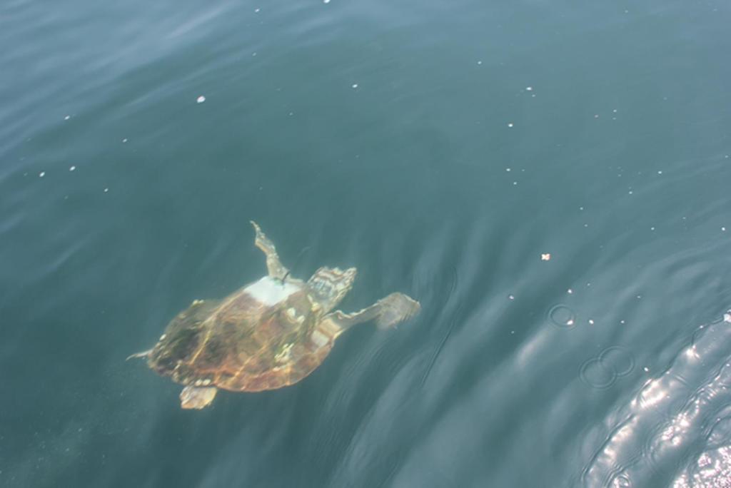
8 Tag Types 17 Sea Mammal Research Unit 9000x SDRL tags 6 Wildlife Computers SPLASH tags


9 Capture Methods (n=23) 2 dip net 1 swimming enclosure 3 pound net Activities conducted under NMFS Research Permit No rehabilitated
 Utilization distribution (UD): Quantifies the area traversed and")
 of the place (Silverman 1986; Wand and Jones 1995) Isopleths (contour lines): Based on the summed values of each grid intersection in")
10 Home-range: What is Home-Range? Area traversed by an animal during its normal activities of foraging, mating, and migrating (Burt 1943) Utilization distribution (UD): Quantifies the area traversed and the normal activity of an animal s home-range (Van Winkle 1975) Relative density function that reports the probability that an animal will relocate at any place according to the coordinate (x, y) of the place (Silverman 1986; Wand and Jones 1995) Isopleths (contour lines): Based on the summed values of each grid intersection in the UD 95% isopleth = home-range (Worton 1989) Cumulative home-range: Intersection of 95% isopleths Identify relative cumulative use (RCU) classes


11 Methods Point Filtering Combined all GPS and ARGOS points Calculated proxy ARGOS attributes to for GPS data Used Douglas filter identify the best point per day (Douglas et al. 2012; TEWG 2009)
12 Methods UD Calculation UDs are calculated using the reference bandwidth input (Wortan 1995) h ref = n 1 6 var x + var y 2 h ref is based on the standard deviation (Silverman 1986) To compare variances the ratio between Std(x) and Std(y) for each dataset data set was calculated Spatial variance was too great between each turtle s dataset to create one UD for all turtles Calculated UD and 95% isopleth for each animal - in each season (Seaman and Powell 1996) Spring: April-June Summer: July-September Fall: October-December


13 Methods Isopleth Intersection Merge and intersect all isopleths for each season Spring Sum all home-ranges in each intersection for each season Summer Fall
 Reclassify sums into three")

14 Number of Occurrences Methods Relative Cumulative Use (RCU) Reclassify sums into three RCU classes for each season moderate high intensive ArcGIS10 quantile classification Summed Intersections


15 Methods %RCU by Geographic Zone 4,400 46,407 = 9. 5% RCU 4, 400 sq km 46, 407 sq km Separated all RCU layer into geographic zones for each season Calculated the area of total home-range in each zone Calculate the area of each RCU class in all seasons and in all zones Calculated %RCU area for each class in each geographic zone area of seasonal use class area of total home range = %RCU
16 Results
17 Geographic Zone Results - Spring RCU (10 turtles) Spring Intensive Use South NC Ocean NC Ocean/Sound Ches Bay VA Ocean North VA Ocean 0.00% 6.42% 0.00% 0.00% 20.91% 0% 10% 20% 30% 40% 50% Percent Use


18 Geographic Zone Results - Summer RCU (18 turtles) Summer Intensive Use South NC Ocean NC Ocean/Sound Ches Bay VA Ocean North VA Ocean 0.00% 0.00% 3.04% 0.00% 23.19% 0% 10% 20% 30% 40% 50% Percent Use
19 Geographic Zone Results - Fall RCU (15 turtles) Fall Intensive Use South NC Ocean NC Ocean/Sound Chesapeake Bay VA Ocean North VA Ocean 0.32% 0.82% 9.27% 0.00% 31.86% 0% 10% 20% 30% 40% 50% Percent Use


20 What About Moderate & High RCU Areas? Intensive RCU Areas High RCU Areas Moderate RCU Areas

 VA to Gulf Stream")


21 Four Overwintering Categories 17 loggerheads VA to Onslow Bay, NC (n=9) VA to Offshore, NC (n=4) VA to Florida (n=2) VA to Gulf Stream (n=2) *Overwintering data was defined as data from tags that transmitted at least 45 days past the date a turtle left Virginia waters in the fall.
22 Conclusions Cumulative Home-Range Geographic zone with highest percent of intensive relative use shifted seasonally Chesapeake Bay had moderate use in all three seasons Cumulative home-range analysis is a practical tool that identifies intensive use areas using telemetry data Cumulative home-range analysis a dynamic tool for leveraging telemetry data RCU areas can be used to predict times and places of intensive use RCU can inform managers who regulate actions that pose significant risk to sea turtles
23 Next Steps Fine tune and update the model Compare rehabilitated and wild-caught RCU areas Conduct state-space modeling to identify foraging and migration behavior (Jonson et al. 2005) Identify RCU areas for foraging behavior using statespace modeling results Develop a resource selection model Submit geospatial data to NMFS & VDGIF
24 Works Cited Douglas, D. C., R. Weinzierl, S. C. Davidson, R. Kays, M. Wikelski, and G. Bohrer Moderating Argos location errors in animal tracking data. Methods in Ecology and Evolution 3(6): doi: /j X x Jonsen,I.D., Flemming, J.M., Myers, Ransom Robust State-Spaced modeling of Animal Movement Data. Ecology. 86(11), pp Mansfield, K.L., Saba, V.S., Keinath, J.A., Musick, J.A., Satellite tracking reveals a dichotomy in migration strategies among juvenile loggerhead turtles in the Northwest Atlantic. Marine Biology. 156, Millspaugh, J.J., and J.M. Marzluff Radio-tracking and animal populations: past trends and future needs. Pages in J.J. Millspaugh and J.M.Marzluff, editors, Radio-tracking and animal populations. Academic Press, San Diego, CA. Musick, J.A. and Limpus, C.J Habitat utilization and migration in juvenile sea turtles. The Biology of Sea Turtles (eds P.L. Lutz & J.A. Musick), pp CRC Press, Boca Raton. Powell, R.A Animal home-ranges and territories and home-range estimators. Research Techniques in AnimalEcology: Controversies and Consequences (eds L.Boitani & T.K.Fuller), pp Columbia University, New York. Seaman, D.E. and R.A. Powell An evaluation of accuracy or kernel density estimators for homerang analysis. Ecology 77: Turtle Expert Working Group An assessment of the loggerhead: Turtle population in the western North Atlantic Ocean. NOAA Technical Memorandum NMFS-SEFSC-575, 131p. Van Winkle, W Comparison of several probabilistic home-range models. Journal of Wildlife Management 39: Worton, B.J. (1989). Kernel methods for estimating the utilization distribution in home-range studies. Ecology 70:
Sea Turtle Sightings Per Unit Effort (Fall) Northwest Atlantic United States January 2010
 Northwest Atlantic United States January 2010") Sea Turtle Sightings Per Unit Effort (Fall) Northwest Atlantic United States January 2010 Prepared by: Eastern Division Conservation Science Office of The Nature Conservancy 99 Bedford Street, 5 th Floor
Sea Turtle Sightings Per Unit Effort (Fall) Northwest Atlantic United States January 2010 Prepared by: Eastern Division Conservation Science Office of The Nature Conservancy 99 Bedford Street, 5 th Floor
Northeast U.S. Early Season Preview 2017 FISHING ACTION STARTING TO WARM UP ALREADY WITH LOTS OF FISH EXPECTED IN MAY
 Northeast U.S. Early Season Preview 2017 FISHING ACTION STARTING TO WARM UP ALREADY WITH LOTS OF FISH EXPECTED IN MAY By Matthew A. Upton and Mitchell A. Roffer ROFFS concludes its 2017 spring preview
OCEANOGRAPHIC DATA MANAGEMENT
 OCEANOGRAPHIC DATA MANAGEMENT Presented to: Environmental Disaster Data Management Meeting Russ Beard Director, National Coastal Data Development Center Interim Science Coordinator, Gulf Restoration Council
Southern Florida to Cape Hatteras Spring Season Preview 2018 UPDATE ON U.S. EAST COAST GULF STREAM CONDITIONS
 Southern Florida to Cape Hatteras Spring Season Preview 2018 UPDATE ON U.S. EAST COAST GULF STREAM CONDITIONS By ROFFS Gregory J. Gawlikowski ROFFS continues its spring preview series by providing an overall
Your web browser (Safari 7) is out of date. For more security, comfort and. the best experience on this site: Update your browser Ignore
 is out of date. For more security, comfort and. the best experience on this site: Update your browser Ignore") Your web browser (Safari 7) is out of date. For more security, comfort and Activitydevelop the best experience on this site: Update your browser Ignore Rescuing, Relocating, and Rehabilitating Wildlife
Your web browser (Safari 7) is out of date. For more security, comfort and Activitydevelop the best experience on this site: Update your browser Ignore Rescuing, Relocating, and Rehabilitating Wildlife
Southern Florida to Cape Hatteras Early Season Preview 2017 U.S. EAST COAST GULF STREAM CONDITIONS LOOKING PROMISING
 Southern Florida to Cape Hatteras Early Season Preview 2017 U.S. EAST COAST GULF STREAM CONDITIONS LOOKING PROMISING By Matthew A. Upton and Mitchell A. Roffer ROFFS continues its spring preview series
BOEM Marine Minerals Program
 BOEM Marine Minerals Program Restoring and Protecting Our Nation s Coasts through Stewardship of OCS Sand Resources SECOORA 2018 Annual Meeting May 22-24 Doug Piatkowski Douglas.piatkowski@boem.gov 703-787-1833
Movements of striped bass in response to extreme weather events
 Movements of striped bass in response to extreme weather events Helen Bailey and David Secor E-mail: hbailey@umces.edu 1 Background 2 Outline What is movement ecology? Methods for analyzing animal tracks
East Coast whale, dolphin grounds to endure oil exploration blasts By McClatchy Washington Bureau, adapted by Newsela staff Oct.
 East Coast whale, dolphin grounds to endure oil exploration blasts By McClatchy Washington Bureau, adapted by Newsela staff Oct. 08, 2014 1:00 AM Pictured is a North Atlantic right whale (Eubalaena glacialis).
Monitoring Coastal Change after the Tsunami in Thailand
 IOP Conference Series: Earth and Environmental Science OPEN ACCESS Monitoring Coastal Change after the Tsunami in Thailand To cite this article: W Pantanahiran 2014 IOP Conf. Ser.: Earth Environ. Sci.
Natalie Cabrera GSP 370 Assignment 5.5 March 1, 2018
 Network Analysis: Modeling Overland Paths Using a Least-cost Path Model to Track Migrations of the Wolpertinger of Bavarian Folklore in Redwood National Park, Northern California Natalie Cabrera GSP 370
Introduction to Part III Examining wildlife distributions and abundance using boat surveys
 Baseline Wildlife Studies in Atlantic Waters Offshore of Maryland: Final Report to the Maryland Department of Natural Resources and Maryland Energy Administration, 2015 Introduction to Part III Examining
Soft sediments by grain size (in mm) Northwest Atlantic United States March 2016
 Northwest Atlantic United States March 2016") Soft sediments by grain size (in mm) Northwest Atlantic United States March 2016 Prepared for: Northeast Regional Ocean Council (NROC) Northeast Ocean Data www.northeastoceandata.org Prepared by: Eastern
Soft sediments by grain size (in mm) Northwest Atlantic United States March 2016 Prepared for: Northeast Regional Ocean Council (NROC) Northeast Ocean Data www.northeastoceandata.org Prepared by: Eastern
Likelihood Cross-Validation Versus Least Squares Cross- Validation for Choosing the Smoothing Parameter in Kernel Home-Range Analysis
 Research Article Likelihood Cross-Validation Versus Least Squares Cross- Validation for Choosing the Smoothing Parameter in Kernel Home-Range Analysis JON S. HORNE, 1 University of Idaho, Department of
Abstract. Introduction
 Southern California Aquaculture Site Assessment Model Caitlyn Raines University of Redlands Master of Science in Geographic Information Systems Program Abstract The Southern California Aquaculture Site
Putative Canada Lynx (Lynx canadensis) Movements across I-70 in Colorado
 Movements across I-70 in Colorado") Putative Canada Lynx (Lynx canadensis) Movements across I-70 in Colorado INTRODUCTION March 8, 2012 Jake Ivan, Mammals Researcher Colorado Parks and Wildlife 317 W. Prospect Fort Collins, CO 80526 970-472-4310
Putative Canada Lynx (Lynx canadensis) Movements across I-70 in Colorado INTRODUCTION March 8, 2012 Jake Ivan, Mammals Researcher Colorado Parks and Wildlife 317 W. Prospect Fort Collins, CO 80526 970-472-4310
Sea ice cycle in western Hudson Bay, Canada, from a polar bear perspective
 The following supplement accompanies the article Sea ice cycle in western Hudson Bay, Canada, from a polar bear perspective L. Castro de la Guardia*, P. G. Myers, A. E. Derocher, N. J. Lunn, A. D. Terwisscha
How and why is the timing and occurrence of seasonal migrants in the Gulf of Maine changing due to climate?
 How and why is the timing and occurrence of seasonal migrants in the Gulf of Maine changing due to climate? Dan Pendleton, ACCOL @ the New England Aquarium with PIs Michelle Staudinger & Adrian Jordaan
9.0 Consistency with the Magnuson-Stevens Fishery Conservation and Management Act (MSFCMA)
") 9.0 Consistency with the Magnuson-Stevens Fishery Conservation and Management Act (MSFCMA) This analysis was prepared in accordance with the requirements of the Magnuson- Stevens Fishery Conservation and
9.0 Consistency with the Magnuson-Stevens Fishery Conservation and Management Act (MSFCMA) This analysis was prepared in accordance with the requirements of the Magnuson- Stevens Fishery Conservation and
Climate Change and Baleen Whale Trophic Cascades in Greenland
 Climate Change and Baleen Whale Trophic Cascades in Greenland Kristin L. Laidre Polar Science Center, Applied Physics Laboratory, University of Washington, 1013 NE 40th St. Seattle, WA 98105 USA phone:
A Characteristic-Hull Based Method for Home Range Estimationtgis_
 : 527 537 Research Article A Characteristic-Hull Based Method for Home Range Estimationtgis_1177 527..537 Joni A Downs Department of Geography University of South Florida Mark W Horner Department of Geography
CHAPTER ONE. Introduction
 CHAPTER ONE Introduction The advent of radio telemetry in the late 1950s revolutionized the study of animal movement, enabling the systematic measurement of animal movement patterns (Cochran and Lord 1963).
Habitat Suitability for Forage Fishes in Chesapeake Bay
 Habitat Suitability for Forage Fishes in Chesapeake Bay Aug 2017 Jul 2019 Mary C Fabrizio Troy D Tuckey Aaron J Bever Michael L MacWilliams 21 June 2018 Photo: Chesapeake Bay Program Motivation Production
Grant Opportunity Monitoring Bi-State Sage-grouse Populations in Nevada
 Grant Opportunity Monitoring Bi-State Sage-grouse Populations in Nevada Proposals are due no later than November 13, 2015. Grant proposal and any questions should be directed to: Shawn Espinosa @ sepsinosa@ndow.org.
SEDAR 42- DW November 2014
 Red Grouper Abundance Indices from NMFS Bottom Longline Surveys in the Northern Gulf of Mexico Adam G. Pollack and G. Walter Ingram, Jr. SEDAR 42- DW- 06 19 November 2014 This information is distributed
Using GIS and Remote Sensing to Manage North Atlantic Right Whale Populations Eleni Gesch-Karamanlidis
 Using GIS and Remote Sensing to Manage North Atlantic Right Whale Populations Eleni Gesch-Karamanlidis Northern Right whales remain one of the most endangered mammals in the ocean (Ward-Geiger et al 2005,
Climate Variability and El Niño
 Climate Variability and El Niño David F. Zierden Florida State Climatologist Center for Ocean Atmospheric Prediction Studies The Florida State University UF IFAS Extenstion IST January 17, 2017 The El
What Maintains the Western Gulf of Maine Cod Stock?
 What Maintains the Western Gulf of Maine Cod Stock? James Churchill Woods Hole Oceanographic Inst.; Woods Hole MA, jchurchill@whoi.edu, Jeffrey Runge School of Marine Sciences, University of Maine, Gulf
An Evaluation of the Accuracy of Kernel Density Estimators for Home Range Analysis
 An Evaluation of the Accuracy of Kernel Density Estimators for Home Range Analysis D. Erran Seaman; Roger A. Powell Ecology, Vol. 77, No. 7. (Oct., 1996), pp. 2075-2085. Stable URL: http://links.jstor.org/sici?sici=0012-9658%28199610%2977%3a7%3c2075%3aaeotao%3e2.0.co%3b2-%23
Vegetation and Wildlife Habitat Mapping Study in the Upper and Middle Susitna Basin Study Plan Section 11.5
 (FERC No. 14241) Vegetation and Wildlife Habitat Mapping Study in the Upper and Middle Susitna Basin Study Plan Section 11.5 Initial Study Report Part C: Executive Summary and Section 7 Prepared for Prepared
Boundary Expansion of Thunder Bay National Marine Sanctuary; Correction and Expansion of Fagatele Bay National Marine
 This document is scheduled to be published in the Federal Register on 12/23/2015 and available online at http://federalregister.gov/a/2015-32265, and on FDsys.gov Billing Code 3510-NK-P DEPARTMENT OF COMMERCE
ESRM 350 Habitat Use Autumn 2016
 ESRM 350 Habitat Use Autumn 2016 When you come to a fork in the road, take it - Yogi Berra Wildlife: The Basic Needs All animals must negotiate the physical environment - i.e., be able to meet the challenge
Seabed Forms Northwest Atlantic United States March 2016
 Seabed Forms Northwest Atlantic United States March 2016 Prepared for: Northeast Regional Ocean Council (NROC) Northeast Ocean Data www.northeastoceandata.org Prepared by: Eastern Division Conservation
A National Outer Continental Shelf Sand / Sediment Inventory
 A National Outer Continental Shelf Sand / Sediment Inventory Sand Resource Areas Lease Areas Lora Turner December 15, 2016 Restoring and Protecting Our Nation s Coasts through Stewardship of OCS Resources
Post-Graduation Plans stock assessment scientist (NOAA, hopefully)
") Update Report Period 3/1/2013-2/28/2014 Project E/I-20 - NMFS Population Dynamics Sea Grant Graduate Fellowship An evaluation of the stock assessment method for eastern Bering Sea snow crab incorporating
Update Report Period 3/1/2013-2/28/2014 Project E/I-20 - NMFS Population Dynamics Sea Grant Graduate Fellowship An evaluation of the stock assessment method for eastern Bering Sea snow crab incorporating
Developing a Seabed Resurvey Strategy: A GIS approach to modelling seabed changes and resurvey risk
 Developing a Seabed Resurvey Strategy: A GIS approach to modelling seabed changes and resurvey risk A. M. Bakare, J. G. Morley, R. R. Simons Department of Geomatic Engineering, University College London,
Reproductive parameters for Atlantic sharpnose sharks (Rhizoprionodon terraenovae) from the western North Atlantic Ocean SEDAR34-WP-30
 from the western North Atlantic Ocean SEDAR34-WP-30") Reproductive parameters for Atlantic sharpnose sharks (Rhizoprionodon terraenovae) from the western North Atlantic Ocean William B. Driggers III, Eric R. Hoffmayer, John K. Carlson and Joshua Loefer SEDAR34-WP-30
Reproductive parameters for Atlantic sharpnose sharks (Rhizoprionodon terraenovae) from the western North Atlantic Ocean William B. Driggers III, Eric R. Hoffmayer, John K. Carlson and Joshua Loefer SEDAR34-WP-30
Spatial Analyses of Bowhead Whale Calls by Type of Call. Heidi Batchelor and Gerald L. D Spain. Marine Physical Laboratory
 1 Spatial Analyses of Bowhead Whale Calls by Type of Call 2 3 Heidi Batchelor and Gerald L. D Spain 4 5 Marine Physical Laboratory 6 Scripps Institution of Oceanography 7 291 Rosecrans St., San Diego,
Managing Grizzly Bear Data. ESRI 2009 International User Conference, San Diego, California Presented by: Julie Duval, July 15, 2009
 Managing Grizzly Bear Data ESRI 2009 International User Conference, San Diego, California Presented by: Julie Duval, July 15, 2009 Agenda 1) Overview of the Foothills Research Institute 2) Grizzly Bear
The Effect of Home Range Estimation Techniques on Habitat Use Analysis
 University of South Florida Scholar Commons Graduate Theses and Dissertations Graduate School 6-30-2016 The Effect of Home Range Estimation Techniques on Habitat Use Analysis Brendon Quinton University
Evaluating Physical, Chemical, and Biological Impacts from the Savannah Harbor Expansion Project Cooperative Agreement Number W912HZ
 Evaluating Physical, Chemical, and Biological Impacts from the Savannah Harbor Expansion Project Cooperative Agreement Number W912HZ-13-2-0013 FY 2016 - First Quarterly Report January 1, 2016 Submitted
SARGASSUM EARLY ADVISORY SYSTEM (SEAS): A comparison of. Sargassum landing amounts vs cold fronts on the Gulf Coast. A Whitepaper from the SEAS Team
: A comparison of. Sargassum landing amounts vs cold fronts on the Gulf Coast. A Whitepaper from the SEAS Team") SARGASSUM EARLY ADVISORY SYSTEM (SEAS): A comparison of Sargassum landing amounts vs cold fronts on the Gulf Coast A Whitepaper from the SEAS Team By Brandon N. Hill, Andy Rydzak, Capt. Robert Webster,
SARGASSUM EARLY ADVISORY SYSTEM (SEAS): A comparison of Sargassum landing amounts vs cold fronts on the Gulf Coast A Whitepaper from the SEAS Team By Brandon N. Hill, Andy Rydzak, Capt. Robert Webster,
Ecological and Economic Effects of Derelict Fishing Gear in the Chesapeake Bay. Amy V. Uhrin Chief Scientist NOAA Marine Debris Program
 Ecological and Economic Effects of Derelict Fishing Gear in the Chesapeake Bay Amy V. Uhrin Chief Scientist NOAA Marine Debris Program Briefing for: Chesapeake Bay Program Management Board October 13,
Fine-scale Survey of Right and Humpback Whale Prey Abundance and Distribution
 DISTRIBUTION STATEMENT A: Approved for public release; distribution is unlimited. Fine-scale Survey of Right and Humpback Whale Prey Abundance and Distribution Joseph D. Warren School of Marine and Atmospheric
The transition zone chlorophyll front, a dynamic global feature defining migration and forage habitat for marine resources
 Progress in Oceanography 49 (2001) 469 483 www.elsevier.com/locate/pocean The transition zone chlorophyll front, a dynamic global feature defining migration and forage habitat for marine resources Jeffrey
Condition Monitoring: A New System for Drought Impacts Reporting through CoCoRaHS
 Condition Monitoring: A New System for Drought Impacts Reporting through CoCoRaHS Amanda Farris Carolinas Integrated Sciences & Assessments (CISA) University of South Carolina WERA 1012 Annual Conference
BOEM G&G DPEIS Page 2
 Mr. Gary D. Goeke, Chief, Regional Assessment Section Office of Environment (MS 5410) Bureau of Ocean Energy Management Gulf of Mexico OCS Region 1201 Elmwood Park Blvd. New Orleans, Louisiana 70123-2394
OCTOBER 24-26,1982, ATLANTIC COAST STORM: A CHRONOLOGY AND INSIGHT
 Severe Weather Volume 9 Number 1 OCTOBER 24-26,1982, ATLANTIC COAST STORM: A CHRONOLOGY AND INSIGHT David B. Caldwell (1) National Weather Service Forecast Office 5200 Aulh Road Washlnglon, D.C. 20233
NOAA s OCM: Services, tools and collaboration opportunities & Puerto Rico s NE Marine Corridor as a case study
 NOAA s OCM: Services, tools and collaboration opportunities & Puerto Rico s NE Marine Corridor as a case study Dr. Antares Ramos Álvarez NOAA s Office of Coastal Management September 15 th, 2016 Conservation
Hurricane Wilma Post Storm Data Acquisition Estimated Peak Wind Analysis and Storm Tide Data. December 27, 2005
 Hurricane Wilma Post Storm Data Acquisition Estimated Peak Wind Analysis and Storm Tide Data December 27, 2005 Hurricane Wilma was the sixth major hurricane of the record-breaking 2005 Atlantic hurricane
The DEPONS project Disturbance Effects on the Harbour Porpoise Population in the North Sea
 The DEPONS project Disturbance Effects on the Harbour Porpoise Population in the North Sea Jacob Nabe-Nielsen, Aarhus University ASCOBANS meeting Wilhelmshaven, 20 June 2017 Modelling cumulative effects
Modeling dispersal kernals with limited. information. Douglas T. Fischer, Louis W. Botsford, David M. Kaplan, J. William White, John Largier
 Modeling dispersal kernals with limited http://www.nmfs.noaa.gov/habitat/ habitatprotection/profile/pacificcouncil.htm information Douglas T. Fischer, Louis W. Botsford, David M. Kaplan, J. William White,
Climate change and baleen whale trophic cascades in Greenland
 Climate change and baleen whale trophic cascades in Greenland Kristin L. Laidre Polar Science Center, Applied Physics Laboratory, University of Washington, 1013 NE 40th St. Seattle, WA 98105 USA Phone:
CORRELATION ANALYSIS BETWEEN PALAEMONETES SHRIMP AND VARIOUS ALGAL SPECIES IN ROCKY TIDE POOLS IN NEW ENGLAND
 CORRELATION ANALYSIS BETWEEN PALAEMONETES SHRIMP AND VARIOUS ALGAL SPECIES IN ROCKY TIDE POOLS IN NEW ENGLAND Douglas F., Department of Biology,, Worcester, MA 01610 USA (D@clarku.edu) Abstract Palamonetes
A Geographic Information System Based Model John L Marshall Geography 562 GIS Coastal Resources - Final Project: Fall 2017 University of Washington
 EFFECTS OF OYSTER CULTURE ON NATIVE EELGRASS AND RELATED NATURAL RESOURCES IN THE PUGET SOUND A Geographic Information System Based Model John L Marshall Geography 562 GIS Coastal Resources - Final Project:
WESTERN GRAY WHALE ADVISORY PANEL WGWAP 5/18 5 th Meeting December 2008 ENGLISH. Comparison of shore-based scan counts WGWAP 5/18
 WESTERN GRAY WHALE ADVISORY PANEL WGWAP 5/18 5 th Meeting December 2008 ENGLISH Comparison of shore-based scan counts WGWAP 5/18 Comparison of Shore-Based Scan Counts Background As part of the recommendations
Salinity Gradients in the Mission-Aransas National Estuarine Research Reserve. Kimberly Bittler GIS and Water Resources Fall 2011
 Salinity Gradients in the Mission-Aransas National Estuarine Research Reserve Kimberly Bittler GIS and Water Resources Fall 2011 INTRODUCTION Freshwater inflow has a widely recognized influence on estuary
13.1. Ecologists Study Relationships. Ecologists study environments at different levels of organization.
 13.1 Ecologists Study Relationships VOCABULARY ecology community ecosystem biome KEY CONCEPT Ecology is the study of the relationships among organisms and their environment. Main Ideas Ecologists study
SPATIAL CHARACTERISTICS OF THE SURFACE CIRCULATION AND WAVE CLIMATE USING HIGH-FREQUENCY RADAR
 SPATIAL CHARACTERISTICS OF THE SURFACE CIRCULATION AND WAVE CLIMATE USING HIGH-FREQUENCY RADAR Apisit Kongprom,Siriluk Prukpitikul, Varatip Buakaew, Watchara Kesdech, and Teerawat Suwanlertcharoen Geo-Informatics
INCORPORATING RESOURCE UTILIZATION DISTRIBUTIONS INTO THE STUDY OF RESOURCE SELECTION: DEALING WITH SPATIAL AUTOCORRELATION
 INCORPORATING RESOURCE UTILIZATION DISTRIBUTIONS INTO THE STUDY OF RESOURCE SELECTION: DEALING WITH SPATIAL AUTOCORRELATION JEFFREY A. HEPINSTALL 1, College of Forest Resources, University of Washington,
Quantifying effects of oil on coastal dune vegetation. Thomas Miller and Elise Gornish Biological Science, Florida State University
 Quantifying effects of oil on coastal dune vegetation Thomas Miller and Elise Gornish Biological Science, Florida State University Natural History of Barrier Islands in the Northern Gulf Make up ~70% of
Gabriela Jeronimo NRS 509 Using GIS and Remote Sensing to Detect Seasonal Habitat Changes
 Gabriela Jeronimo NRS 509 Using GIS and Remote Sensing to Detect Seasonal Habitat Changes The increase of the human population has not only altered the landscape by fragmentation but has left long-term
Environmental Sensitivity to Oil Spills in Gulf Shores, AL
 1 Environmental Sensitivity to Oil Spills in Gulf Shores, AL Prepared by: Matthew Dobbertien 2 December 2011 CE 394K: GIS in Water Resources Dr. David Maidment University of Texas at Austin 1 2 Content
Bob Van Dolah. Marine Resources Research Institute South Carolina Department of Natural Resources
 Bob Van Dolah Marine Resources Research Institute South Carolina Department of Natural Resources Shoreline Change Will Occur! On our front beaches where it is not easy to retreat Shoreline Change Will
Gear data report from Atlantic plankton cruises for the R/V Pathfinder, March March 1962
 College of William and Mary W&M ScholarWorks Reports 1962 Gear data report from Atlantic plankton cruises for the R/V Pathfinder, March 1961 - March 1962 Woodrow L. Wilson Virginia Institute of Marine
Long term change in the abundances of northern Gulf of Mexico scyphomedusae Chrysaora sp. and Aurelia spp. with links to climate variability
 Long term change in the abundances of northern Gulf of Mexico scyphomedusae Chrysaora sp. and Aurelia spp. with links to climate variability Kelly L. Robinson William M. Graham U. Southern Mississippi
Comparing male densities and fertilization rates as potential Allee effects in Alaskan and Canadian Ursus maritimus populations
 Comparing male densities and fertilization rates as potential Allee effects in Alaskan and Canadian Ursus maritimus populations Introduction Research suggests that our world today is in the midst of a
Climate Change and Baleen Whale Trophic Cascades in Greenland
 Climate Change and Baleen Whale Trophic Cascades in Greenland Kristin L. Laidre Polar Science Center, Applied Physics Laboratory, University of Washington, 1013 NE 40th St. Seattle, WA 98105 USA phone:
Hurricane Season 2010 & NOAA s Deepwater Response
 Hurricane Season 2010 & NOAA s Deepwater Response What s Happened? What Will 2010 Bring? Possible Shoreline Effects Darin Figurskey Meteorologist-in-Charge NOAA s NWS Raleigh, NC NOAA s National Weather
MECHANISTIC HOME RANGE MODELS AND RESOURCE SELECTION ANALYSIS: A RECONCILIATION AND UNIFICATION
 Ecology, 89(4), 2008, pp. 1112 1119 Ó 2008 by the Ecological Society of America MECHANISTIC HOME RANGE MODELS AND RESOURCE SELECTION ANALYSIS: A RECONCILIATION AND UNIFICATION PAUL R. MOORCROFT 1,3 AND
Serial No. N4470 NAFO SCR Doc. 01/83 SCIENTIFIC COUNCIL MEETING SEPTEMBER 2001
 NOT TO BE CITED WITHOUT PRIOR REFERENCE TO THE AUTHOR(S) Northwest Atlantic Fisheries Organization Serial No. N7 NAFO SCR Doc. /8 SCIENTIFIC COUNCIL MEETING SEPTEMBER Sea-surface Temperature and Water
SW Florida Escarpment Mapping Area
 Overview NOAA s Okeanos Explorer (EX) Program plans to conduct systematic mapping and telepresence-enabled ROV explorations in the Gulf of Mexico during Spring 2014. In 2011, the EX conducted mapping operations
Tropical Update. 5 AM EDT Thursday, September 7, 2017 Hurricane Irma, Hurricane Jose, and Hurricane Katia
 Tropical Update 5 AM EDT Thursday, September 7, 2017 Hurricane Irma, Hurricane Jose, and Hurricane Katia This update is intended for government and emergency response officials, and is provided for informational
7B.4 ASSESSMENT OF THE GROSS U.S. OFFSHORE WIND ENERGY POTENTIAL
 7B.4 ASSESSMENT OF THE GROSS U.S. OFFSHORE WIND ENERGY POTENTIAL Marc Schwartz, Donna Heimiller, Steve Haymes, and Walt Musial National Renewable Energy Laboratory, Golden, Colorado 1. INTRODUCTION Offshore
The Science of Sea Level Rise and the Impact of the Gulf Stream
 Old Dominion University ODU Digital Commons July 29, 2016: The Latest in Sea Level Rise Science Hampton Roads Sea Level Rise/Flooding Adaptation Forum 7-29-2016 The Science of Sea Level Rise and the Impact
Application #: TEXT
 TOWN OF FORT MYERS BEACH 2008 PROPOSED COMPREHENSIVE PLAN AMENDMENTS Application #: 2008-13-TEXT Description: Modify the Coastal Management and Future Land Use Elements to reflect the state s new definition
Near-Field Sturgeon Monitoring for the New NY Bridge at Tappan Zee. Quarterly Report October 1 December 31, 2014
 Near-Field Sturgeon Monitoring for the New NY Bridge at Tappan Zee Quarterly Report October 1 December 31, 2014 Prepared by AKRF, Inc. 7250 Parkway Drive, Suite 210 Hanover, MD 21076 for New York State
Satellite-derived environmental drivers for top predator hotspots
 Satellite-derived environmental drivers for top predator hotspots Peter Miller @PeterM654 South West Marine Ecosystems 2017 21 Apr. 2017, Plymouth University Satellite environmental drivers for hotspots
GenCade. Combining and Extending the GENESIS and Cascade Models for Planning and Design in a Regional Sediment Management Framework
 GenCade Combining and Extending the GENESIS and Cascade Models for Planning and Design in a Regional Sediment Management Framework G Presented by Nicholas C. Kraus For the GenCade Development Team Ken
An Evaluation of the Accuracy of Kernel Density Estimators for Home Range Analysis
 An Evaluation of the Accuracy of Kernel Density Estimators for Home Range Analysis D. Erran Seaman; Roger A. Powell Ecology, Vol. 77, No. 7. (Oct., 1996), pp. 2075-2085. http://links.jstor.org/sici?sici=0012-9658%28199610%2977%3a7%3c2075%3aaeotao%3e2.0.co%3b2-%23
SAFMC Habitat and Ecosystem IMS. Habitat and Environmental Protection Advisory Panel Meeting
 SAFMC Habitat and Ecosystem IMS Habitat and Environmental Protection Advisory Panel Meeting Charleston, SC November 18, 2008 Project Overview Phase 1 develop and host an Internet Map Server (IMS) application
The Use of Geographic Information Systems to Assess Change in Salt Marsh Ecosystems Under Rising Sea Level Scenarios.
 The Use of Geographic Information Systems to Assess Change in Salt Marsh Ecosystems Under Rising Sea Level Scenarios Robert Hancock The ecological challenges presented by global climate change are vast,
A TOOLKIT FOR MARINE SPATIAL PLANNING Version: 17 July, 2009
 A TOOLKIT FOR MARINE SPATIAL PLANNING Version: 17 July, 2009 NEED FOR MARINE SPATIAL PLANNING The health of marine ecosystems is declining, and use conflicts in the marine environment are increasing, in
R. Michael Laurs 1, David G. Foley 2, and Michael Musyl 2. RML Fisheries Oceanographer Consultant, LLC, Jacksonville, OR USA
 Update on Research Regarding Identification and Utilization Of Habitats by Large Pacific Sharks Using PSAT Archival Tags, Oceanic Satellite Remote Sensing, and SODA Ocean Assimilation Model Analyses R.
APPENDIX B PHYSICAL BASELINE STUDY: NORTHEAST BAFFIN BAY 1
 APPENDIX B PHYSICAL BASELINE STUDY: NORTHEAST BAFFIN BAY 1 1 By David B. Fissel, Mar Martínez de Saavedra Álvarez, and Randy C. Kerr, ASL Environmental Sciences Inc. (Feb. 2012) West Greenland Seismic
Beaches Carrying Capacity Assessment in Kuwait Based on Photointerpretation and Ground Survey
 Technical Session: TS 07B - GIS Applications (Number # 5463) Beaches Carrying Capacity Assessment in Kuwait Based on Photointerpretation and Ground Survey Prof. Mohamed AIT BELAID Shaikh Hamad Bin Khalifa
Peter Gaube EDUCATION
 Peter Gaube Applied Physics Laboratory Department of Air-Sea Interaction and Remote Sensing (AIRS) Box 355640 University of Washington 1013 NE 40th Street Seattle, WA 98105-6698 (520) 248-1939 pgaube@apl.washington.edu
GROUNDFISH AMENDMENT 28 REGULATION DEVELOPMENT UPDATE
 Agenda Item I.2.a NMFS Report 1 September 2018 GROUNDFISH AMENDMENT 28 REGULATION DEVELOPMENT UPDATE In drafting regulations for the Council s final preferred alternative for Amendment 28, recommended
Bear Conservation. Recolonization. Reintroduction IDENTIFYING POTENTIAL COLONIZATION PATTERNS FOR REINTRODUCED BLACK BEAR POPULATIONS
 IDENTIFYING POTENTIAL COLONIZATION PATTERNS FOR REINTRODUCED BLACK BEAR POPULATIONS Jared Laufenberg Department of Forestry, Wildlife and Fisheries University of Tennessee Bear Conservation Distribution
Spatial variation in the abundance of eelgrass (Zostera marina) at eight sites in western Newfoundland, Canada 5/5/2015 V2.0
 at eight sites in western Newfoundland, Canada 5/5/2015 V2.0") Spatial variation in the abundance of eelgrass (Zostera marina) at eight sites in western Newfoundland, Canada 5/5/2015 V2.0 1 Summary The abundance of eelgrass (Zostera marina) was quantified at eight
Spatial variation in the abundance of eelgrass (Zostera marina) at eight sites in western Newfoundland, Canada 5/5/2015 V2.0 1 Summary The abundance of eelgrass (Zostera marina) was quantified at eight
Weather and Climate Summary and Forecast Summer 2017
 Weather and Climate Summary and Forecast Summer 2017 Gregory V. Jones Southern Oregon University August 4, 2017 July largely held true to forecast, although it ended with the start of one of the most extreme
Societal impacts of inland moving tropical cyclones across the southeastern U.S
 Societal impacts of inland moving tropical cyclones across the southeastern U.S Maggie M. Kovach, Gretchen Carlson, Charles E. Konrad II NOAA Southeast Regional Climate Center Department of Geography University
An Environmental Science Curriculum Utilizing GIS and Satellite-Based Wildlife Tracking
 An Environmental Science Curriculum Utilizing GIS and Satellite-Based Wildlife Tracking Michelle Frankel, M. Blake Henke, Jack Cibor, and William S. Seegar Abstract The Eye of the Falcon is an interdisciplinary
The Use of GIS and RS Technology to Study Sea Duck Ecology
 Josh Beuth NRS 509 Fall 2011 The Use of GIS and RS Technology to Study Sea Duck Ecology Sea birds inhabit the coastal areas of most places on earth. In the United States, some sea birds inhabit near coastal
Describing Greater sage-grouse (Centrocercus urophasianus) Nesting Habitat at Multiple Spatial Scales in Southeastern Oregon
 Nesting Habitat at Multiple Spatial Scales in Southeastern Oregon") Describing Greater sage-grouse (Centrocercus urophasianus) Nesting Habitat at Multiple Spatial Scales in Southeastern Oregon Steven Petersen, Richard Miller, Andrew Yost, and Michael Gregg SUMMARY Plant
Describing Greater sage-grouse (Centrocercus urophasianus) Nesting Habitat at Multiple Spatial Scales in Southeastern Oregon Steven Petersen, Richard Miller, Andrew Yost, and Michael Gregg SUMMARY Plant
3/29/11. Why bother with tools? Incorporating Decision Support Tools into Climate Adaptation Planning. A Simplified Planning Process
 Incorporating Decision Support Tools into Climate Adaptation Planning Why bother with tools? Tools don t eliminate complexity but they can help deal with it" Tools can:"! Help incorporate science into
Performance of the ocean wave ensemble forecast system at NCEP 1
 Performance of the ocean wave ensemble forecast system at NCEP 1 Degui Cao 2,3, Hendrik L. Tolman, Hsuan S.Chen, Arun Chawla 2 and Vera M. Gerald NOAA /National Centers for Environmental Prediction Environmental
Median surface chlorophyll-a concentration Northwest Atlantic United States March 2016
 Median surface chlorophyll-a concentration 2003-2015 Northwest Atlantic United States March 2016 Prepared for: Northeast Regional Ocean Council (NROC) Northeast Ocean Data northeastoceandata.org Prepared
PROGRESS REPORT for COOPERATIVE BOBCAT RESEARCH PROJECT. Period Covered: 1 January 31 May Prepared by
 PROGRESS REPORT for COOPERATIVE BOBCAT RESEARCH PROJECT Period Covered: 1 January 31 May 2011 Prepared by John A. Litvaitis, Derek Broman, and Marian K. Litvaitis Department of Natural Resources University
Weather and Climate Summary and Forecast October 2017 Report
 Weather and Climate Summary and Forecast October 2017 Report Gregory V. Jones Linfield College October 4, 2017 Summary: Typical variability in September temperatures with the onset of fall conditions evident