International Charter: Space and Major Disasters
|
|
|
- Alfred Hopkins
- 6 years ago
- Views:
Transcription


1 International Charter: Space and Major Disasters UNESCAP Training Workshop Kathmandu Nepal Oct 2017 Dr. N K Shrivastava (shrivastava.nk@gmail.com) Former Charter Executive Secretariat Member Dy. Director, ISTRAC/ISRO (Retd.) Bangalore, India
2 Space System for Disaster Management Limitations of ground-based systems for immediate & precise assessment of the disasters. Space based Disaster Management System (DMS) provides precise, unbiased, synoptic and timely information on the nature and impact of the disaster affected areas - extent of damage.


3 DMS - Space enabled Products & Services Space for Observation and Connectivity Observation for Information and Knowledge Leading to Decision and Action FLOOD MAP DROUGHT MAP DAMAGE MAP HAZARD ZONES RISK MAP Disaster Warning, Vulnerability Assessment, Emergency Communications,...
4 Need for International Co-operation No single space agency can provide imaging capability to meet the spatial and temporal requirements of different types of disasters. Important Parameters for Disaster Imaging: Turn - Around-Time Resolution Coverage Specific Imaging Sensors (Different space sensors (Thermal, Microwave, Optical) required for Different Disasters (Fire, Floods, EQ). Hence the need for a Global System for disaster management, supported by multi-satellite and multi-imaging capabilities This led to setting up of International Charter: Space and Major Disasters
5 About the Charter World s first coordinated multi-satellite operational Setup for emergency response Introduced at Space Assembly (UNISPACE III) in 1999 ESA & CNES and later Joined by CSA Operational from Nov 1, 2000 Currently 16 Global Agencies are members Satellite imagery provided at no cost to the user Over 17 years, the Charter has had a large fleet of satellites, tools & techniques developed to help support end-to-end needs of disaster managers.
6 Purpose An International Agreement among Space Agencies to support with space-based data and information for relief efforts in the emergencies caused by major Disasters, on Humanitarian ground at no cost.

7 The Charter scope: Immediate Response only


8 Charter Members CSA Canada NOAA USGS USA ABAE Venezuela INPE Brasil UKSA/DMC UK CNES France DLR Germany Europe ESA EUMETSAT ROSCOSMOS Russia CNSA China ISRO India KARI Korea JAXA Japan CONAE Argentina
9 Disasters Types Supported The International Charter executes priority tasking of different EO missions in a rapid fashion; it is designed to address major disasters caused by: Natural events Floods Earthquakes Accidents Forest Fires Landslides Tsunamis Ocean storms Volcanic eruptions Man-made events Oil spills Industrial
.")
10 Authorized Users (AU) Globally Typically civil protection agencies, governmental relief organizations, or other authorities with a mandate related to disaster management Countries with Authorized Users (April 2016). Today 58 AUs from 50 countries and the European Commission (EC).
")


 ESA CNES CSA")

11 Charter Operational Loop ON-DUTY OPERATOR (ODO) AUTHORIZED USER (AU) EMERGENCY ON-CALL OFFICER (ECO) PROJECT MANAGER (PM) MEMBER AGENCY MISSION PLANNING VALUE- ADDED PROVIDER (VAP) ESA CNES CSA USGS NOAA UKSA/DMC JAXA CNSA CONAE ISRO DLR INPE KARI EUMETSAT ROSCOSMOS DISASTER END USER (EU)

12 Activation Distribution (520+ in 120+ Countries)
13 Activations by Disaster Type Ice/Snow hazard 1% Storm/Hurricane 16% Earthquake 11% Landslide 4% Volcano 6% Oil spill 3% Fire 6% Others 2% Flood/Ocean wave 51% As of April 8, Charter Activations
14 Number of Activations November 2000 to December 2016: 517 Charter Activations
15 Distribution of Activations by Hazard Type Earthquake Landslide 15 Volcano Oil spill Others 10 5 Fire Flood/Ocean wave* Ice/Snow hazard *Includes solid earth related phenomenon of a tsunami. **Includes all wind type storms (hurricane, cyclone, typhoon and tornado). As of December 21, Charter Activations
16 Mechanisms to Activate the Charter Direct activation: Authorized Users (AUs), all member space agencies and Countries approved by Charter Board, these are typically civil protection agencies, governmental relief organizations, or other authorities with a mandate related to disaster management. Activation via an Authorized User on behalf of a user from another country without AU: Authorized Users can access the Charter to request support for a disaster in another country with which they cooperate for relief purposes. Activation via the UN for UN users: The Charter has an agreement with UN OOSA (Vienna) and UNITAR/UNOSAT (Geneva) to provide support to UN agencies, may submit requests on behalf of users from the United Nations. Activation for Asia Pacific users via Sentinel Asia: Sentinel Asia is a regional collaboration for satellite based emergency response in Asia Pacific. Since 2009 the Charter has granted the Asian Disaster Reduction Centre the right to submit activation requests on behalf of national users of Sentinel Asia.


17 West Bengal Floods 2017 Satellite based Study

18 Flood Events In West Bengal during July and August 2017 During the last week of July 2017 heavy rains were reported in several parts of Burdwan, Murshidabad, Hugli, West Medinipur, East Medinipur, Birbhum and Howrah districts in West Bengal. It has been also reported that the most affected areas include Ghatal in West Medinipur, Pursura, Arambagh and Khanakool in Hugli and Amta and Udaynarayanpur in Howrah. The second wave of flood in the north Bengal happened due the heavy rainfall which happed during the 3 rd week of August. The maximum flood inundation was observed during the of August.


19 South Bengal Floods Satellite Observations About 17% of Udaynarayanpur block and 28% of Amta-1 block were inundated Satellite image indicates the recession of flood inundation as on 1-Aug-2017
20 Flood Map North Bengal

21 Land Use / Land Cover

22 Floods in Bangladesh Aug 2017

23 Floods in Bangladesh Aug 2017

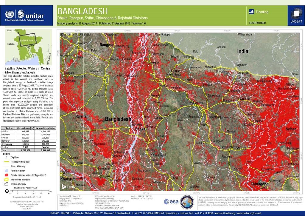
24 Floods in Bangladesh Aug 2017


25 Floods in Sri Lanka May 2017

26 Floods in Sri Lanka May 2017
, NDRF & MHA (India), DFID (UK), COGIC (France), THW (Germany), EMERCOM (Russia), NGA and USGS (USA) Description of the Event: A 7.")

27 Earthquake in Nepal April 2015 Requestor: China National Committee for Disaster Reduction on behalf of disaster emergency management agency in China. End User: MHA & ICIMOD (Nepal), NDRF & MHA (India), DFID (UK), COGIC (France), THW (Germany), EMERCOM (Russia), NGA and USGS (USA) Description of the Event: A 7.8 magnitude earthquake struck Nepal at 11:56 (local time) on 25 April The devastating earthquake has killed over eight thousand people in Nepal, and more than 70 in neighbouring India. The earthquake has been described as the worst disaster to affect Nepal in 80 years and the latest reports list a total of 7566 casualties, with twice that number injured. More than eight million people are affected by the earthquake. Data: Pleiades, Resurs-P, RADARSAT-2, TerraSAR-X, Landsat-8, RapidEye, Worldview1, Worldview2, GeoEye-1, Sentinel-1, GF1, ISS, RADARSAT-2, DMCii, CARTOSAT-1, CARTOSAT-2, RISAT-1, Resourcesat-2, LISS-3, LISS-4, AWIFS, ALOS-2, KOMPSAT-2, KOMPSAT-3, VRSS-1, ASTER and Theos-1.
28 South Asia Satellite Launched on 5th May 2017 by India Coverage over Afghanistan, Nepal, Bhutan, Bangladesh, Sri Lanka, Maldives and India Applications: Broadcasting and telecommunication applications in member countries Emergency Communication during disaster Television/Directto-Home channels VSAT services e-governance & banking cellular backhaul Tele-medicine & Tele-education Secured Hotline Applications of common interest etc..
29 Conclusion Charter is an Excellent Collaboration among space agencies and private entrepreneurs to make space based resources available for planning, monitoring & assessment of disaster relief operations. It has Improved its Resources over the years: new Space Agencies joining as Charter partners, new satellites have been progressively integrated into the Charter constellation (16 Space Agencies) The Charter provides a «one-stop shop» for civil protection and emergency organizations at No Cost The Charter deals with the Immediate Response Phase only It is growing: 520+ disasters covered since 2000 in over 120+ countries worldwide. The Charter is now opening its doors even wider with Universal Access, and is available to National Disaster Mangement Agencies to benefit non-member countries.

30 International Charter Space and Major Disasters Thank You! Emergency enquiries from users requiring direct access to Charter resources should be addressed to: General requests for information should be addressed to:
KARI Activation for the International Disasters
 KARI Activation for the International Disasters 5 th Joint Project Team Meeting for Sentinel Asia STEP2 (JPTM2012) 14 th Nov 2012 Boyeol Yoon Senior Researcher, Satellite Information Research Center (SIRC)
Earth Observation for Emergency Response and the International Charter on Space and Major Disasters.
 Earth Observation for Emergency Response and the International Charter on Space and Major Disasters. Case studies of the 2016 Alberta wildfires and 2017 Québec flooding Simon Tolszczuk-Leclerc 1, Brad
The International Charter Space and Major Disasters is further strengthening its contribution to disaster management worldwide.
 28 September 2012 Issue 3 The International Charter Space and Major Disasters is further strengthening its contribution to disaster management worldwide. Building on a decade of success in making satellite
10 emergency observation requests were successfully processed during the period
 ISRO s Inputs for the Sentinel Asia DPN and JPT meeting being held during 13-16, 16, November 2012 November 2012 Sentinel Asia Activity Spectrum - A dedicated Sentinel Asia server established at NRSC,
Sentinel Asia Data Provider Node Report
 Sentinel Asia Data Provider Node Report Joint Project Team Meeting for Sentinel Asia STEP3 (JPTM2018) 23 24 January 2018, Taipei, Taiwan Yuji TAKADA Space Applications and Operations Center (SAOC) Japan
Exploitation of PROBA CHRIS/HRC data in the context of the International Charter on Space and Major Disasters
 Exploitation of PROBA CHRIS/HRC data in the context of the International Charter on Space and Major Disasters F. Sarti (ESA/ESRIN) H. Yesou, R. Andreoli, S.Clandillon (SERTIT) Charter Member Agencies ESA
Utilization of Satellite for Disaster Management with a Focus on the Sentinel Asia
 2013/01/23 Asian Conference on Reduction 2013 Utilization of Satellite for Management with a Focus on the Sentinel Asia Ichiro NAITO JAXA Space Applications and Promotion Center Management Support Systems
Capacity Building in Applications of Remote Sensing and GIS for Disaster Management
 Capacity Building in Applications of Remote Sensing and GIS for Disaster Management M.K. Hazarika, L. Samarakoon, N. Senevirathne, J.S.M. Fowze and R. de Silva Project Researcher GeoInformatics Center
Emergency Management Service (EMS) mapping
 mapping") GMES Emergency Management Service (EMS) mapping Frédéric BASTIDE GMES unit, European Commission UN-SPIDER Expert Meeting: "Crowdsource Mapping for Disaster Risk Management and Emergency Response" 3-5 December,
GMES Emergency Management Service (EMS) mapping Frédéric BASTIDE GMES unit, European Commission UN-SPIDER Expert Meeting: "Crowdsource Mapping for Disaster Risk Management and Emergency Response" 3-5 December,
Copernicus Overview and Emergency Management Service
 Copernicus Overview and Emergency Management Service Frédéric BASTIDE European Commission Open informal session of the United Nations Inter-Agency Meeting on Outer Space Activities 12 March 2013, Geneva
Copernicus Today and Tomorrow GEO Week Group on Earth Observation Geneva, 16 January 2014 The Copernicus Space Infrastructure
 Copernicus Today and Tomorrow GEO Week Group on Earth Observation Geneva, 16 January 2014 The Copernicus Space Infrastructure Thomas Beer, Policy Coordinator, Copernicus Space Office, ESA-ESRIN, Frascati
sentinel-2 COLOUR VISION FOR COPERNICUS
 sentinel-2 COLOUR VISION FOR COPERNICUS SATELLITES TO SERVE By providing a set of key information services for a wide range of practical applications, Europe s Copernicus programme is providing a step
Natural Disasters in Member Countries (2002 Summary)
") 4.2 Member Countries and their Disaster Characteristics: Table 5: Natural Disasters in Member Countries (2002 Summary) (Country/Disaster Type/Disaster Characteristics) Data Country DisType Count of TotAff
4.2 Member Countries and their Disaster Characteristics: Table 5: Natural Disasters in Member Countries (2002 Summary) (Country/Disaster Type/Disaster Characteristics) Data Country DisType Count of TotAff
Sentinel Asia System Operation for Disaster Management in Sri Lanka Major General L.B.R. Mark (Retd) Director General Disaster Management Centre
 Director General Disaster Management Centre") Sentinel Asia System Operation for Disaster Management in Sri Lanka Major General L.B.R. Mark (Retd) Director General Disaster Management Centre Government of Sri Lanka OUTLINE Background Disasters in
Sentinel Asia System Operation for Disaster Management in Sri Lanka Major General L.B.R. Mark (Retd) Director General Disaster Management Centre Government of Sri Lanka OUTLINE Background Disasters in
Disaster Management and Spatial Data An Experience of Sri Lanka for Joint project team meeting 2012
 Disaster Management and Spatial Data An Experience of Sri Lanka for Joint project team meeting 2012 1 by Padma Kumara Withana Provincial Surveyor General Uva Province 2 Out line ü Introduction ü Natural
earth observation
 earth observation One of the major disasters that stands out in Charter activations was the December 2004 tsunami that caused immense devastation in coastal regions of India and Southeast Asia. A wide
International Charter "Space & Major Disasters"
 International Charter Space & Major Disasters Annual Report 2016 Page 1 Page 2 CONTENTS 1 INTRODUCTION... 5 1.1 PURPOSE AND SCOPE OF THIS DOCUMENT... 5 1.2 STRUCTURE OF THE REPORT... 5 1.3 APPLICABLE DOCUMENTS...
Crisis Management and Natural Disasters Overview of JRC operational or pre-operational activities A. Annunziato, D. Al-Khudhairy
 Papagayo, Costarica 3-4 November 2009 Security Science and The Americas 1 Joint Research Centre (JRC) Crisis Management and Natural Disasters Overview of JRC operational or pre-operational activities A.
RESAP Progress Report
 RESAP Progress Report December 2016 to October 2017 Presentation to the Twenty-first session of the Intergovernmental Consultative Committee on the Regional Space Applications Programme for Sustainable
Current and Upcoming NASA Hurricane Measurement Missions National Hurricane Conference
 NASA Science Mission Directorate Earth Science Division Applied Sciences Program Current and Upcoming NASA Hurricane Measurement Missions National Hurricane Conference April 18, 2017 Formulation Implementation
Establishment of WINDS Ground Station in Sri Lanka. By G.K.D. Amarawardena Additional Secretary Ministry of Disaster Management Sri Lanka
 Establishment of WINDS Ground Station in Sri Lanka By G.K.D. Amarawardena Additional Secretary Ministry of Disaster Management Sri Lanka Contents Background SAS Implementation Progress of WINDS establishment
UN COPUOS 52 nd session of the Scientific and Technical Subcommittee. COPERNICUS - an European Achievement. S. Jutz Head, ESA Copernicus Space Office
 UN COPUOS 52 nd session of the Scientific and Technical Subcommittee COPERNICUS - an European Achievement S. Jutz Head, ESA Copernicus Space Office 11 Feb 2015, Vienna 1 2 What is Copernicus? European
Global Map: A Tool for Disaster Mitigation for the Asia and Pacific Region
 Global Map: A Tool for Disaster Mitigation for the Asia and Pacific Region D. R. Fraser Taylor Chair, International Steering Committee for Global Mapping (ISCGM) fraser_taylor@carleton.ca www. 18 th United
Space-based technology and applications and space science for humanitarian affairs, environment and security
 Space-based technology and applications and space science for humanitarian affairs, environment and security LUC ST-PIERRE United Nations Office for Outer Space Affairs United Nations Office at Vienna
Theme 4. Disaster Mitigation and Risk Management
 Theme 4 Disaster Mitigation and Risk Management World Flood Map in 2002 Released by WMO as of August 29 Over 17 million were affected (in more than 80 countries) 3,000 were killed Total damage of over
Shiro Ochi JAXA
 SESSION 4: Sharing Knowledge and Good Practices by Regional Experts Our Experiences from Japan, Asia and International community Shiro Ochi GIC@AIT, JAXA International Disaster Charter Framework Sentinel
JCOMM-CHy Coastal Inundation Forecasting Demonstration Project (CIFDP)
") WMO World Meteorological Organization Working together in weather, climate and water JCOMM-CHy Coastal Inundation Forecasting Demonstration Project (CIFDP) Coastal Flooding & Vulnerable Populations Coastal
WMO World Meteorological Organization Working together in weather, climate and water JCOMM-CHy Coastal Inundation Forecasting Demonstration Project (CIFDP) Coastal Flooding & Vulnerable Populations Coastal
Geo-information and Disaster Risk Reduction in the Hindu Kush-Himalayan region
 Geo-information and Disaster Risk Reduction in the Hindu Kush-Himalayan region Basanta Shrestha, Division Head MENRIS, International Centre for Integrated Mountain Development Kathmandu, Nepal The International
Bistandsprosjekter i Sørøst-Asia
 Bistandsprosjekter i Sørøst-Asia -Sikre liv og verdier Lars R. Hole, Hanneke Luijting, Tor Ivar Mathisen og Kristine Gjesdal September 2017 Norwegian Meteorological Institute Background Ministry of Foreign
GEO-VIII November Geohazard Supersites and Natural Laboratories Progress Report. Document 9
 GEO-VIII 16-17 November 2011 Geohazard Supersites and Natural Laboratories Progress Report Document 9 This document is submitted to GEO-VIII for information. Geohazard Supersites and Natural Laboratories
South Asian Climate Outlook Forum (SASCOF-6)
") Sixth Session of South Asian Climate Outlook Forum (SASCOF-6) Dhaka, Bangladesh, 19-22 April 2015 Consensus Statement Summary Below normal rainfall is most likely during the 2015 southwest monsoon season
Sixth Session of South Asian Climate Outlook Forum (SASCOF-6) Dhaka, Bangladesh, 19-22 April 2015 Consensus Statement Summary Below normal rainfall is most likely during the 2015 southwest monsoon season
NASA s Activities in Europe
 NASA s Activities in Europe Presented by Dr. Bill Barry NASA European Representative November 10, 2009 at the 2009 International Workshop on Environment and Alternative Energy 2 Current Activities The
Sub-regional Training on development of Geo-referenced Disaster Risk Management Information Systems for SAARC countries
 Sub-regional Training on development of Geo-referenced Disaster Risk Management Information Systems for SAARC countries Jointly organized by Economic and Social Commission for Asia and the Pacific and
Global Monitoring for Environment and Security (GMES)
") Global Monitoring for Environment and Security (GMES) Satellite Earth Observation for the Emergency Services Dr Nick Veck Presentation to the G-STEP Launch Univ. of Leicester 19 th June 2009 Contents of
Global Monitoring for Environment and Security (GMES) Satellite Earth Observation for the Emergency Services Dr Nick Veck Presentation to the G-STEP Launch Univ. of Leicester 19 th June 2009 Contents of
Building Institutional Capacity for Multi-Hazard Early Warning in Asia and the Pacific Subtitle
 Building Institutional Capacity for Multi-Hazard Early Warning in Asia and the Pacific Subtitle Title Keran Wang Chief, Space Applications Section ICT and Disaster Risk Reduction Division 22 May 2018 Pillar
2018 REVIEW OF DISASTER EVENTS
 2018 REVIEW OF DISASTER EVENTS Supplementary Information* BRUSSELS, 24 January, 2019 In 2018, there were 281 climate-related and geophysical events recorded in the EM-DAT (International Disaster Database)
1. Impacts of Natural Disasters by Region, 2008
 1. Impacts of Natural Disasters by Region, 2008 Among all regions across the world in 2008, Asia not only ranks first but also dominates in all natural disaster s impact categories occurrence, killed,
Satellite Remote Sensing for Ocean
 Satellite Remote Sensing for Ocean August 17, 2017 Masatoshi Kamei RESTEC All rights reserved RESTEC 2015 Contents 1. About RESTEC and Remote Sensing 2. Example of Remote Sensing Technology 3. Remote Sensing
Georeferencing and Satellite Image Support: Lessons learned, Challenges and Opportunities
 Georeferencing and Satellite Image Support: Lessons learned, Challenges and Opportunities Shirish Ravan shirish.ravan@unoosa.org UN-SPIDER United Nations Office for Outer Space Affairs (UNOOSA) UN-SPIDER
Bhutan Country Report for JPTM 2010 (July, 2010) Department of Disaster Management Ministry of Home & Cultural Affairs Royal Government of Bhutan
 Department of Disaster Management Ministry of Home & Cultural Affairs Royal Government of Bhutan") Bhutan Country Report for JPTM 2010 (July, 2010) Department of Disaster Management Ministry of Home & Cultural Affairs Royal Government of Bhutan 1 Contents of Presentation 1. Disaster Hazards and Underlying
Bhutan Country Report for JPTM 2010 (July, 2010) Department of Disaster Management Ministry of Home & Cultural Affairs Royal Government of Bhutan 1 Contents of Presentation 1. Disaster Hazards and Underlying
Impact of Cyclone Nargis
 Lessons Learnt from Nargis Recovery for the Next Disaster International Recovery Forum (2011) 12, JAN 2011, Kobe, Japan Home for over 100 national races. Profile of Myanmar The 2 nd largest country in
The Inter-Agency Space Debris Coordination Committee (IADC)
") The Inter-Agency Space Debris Coordination Committee (IADC) An overview of IADC s annual activities Mitsuru Ohnishi, JAXA, Japan IADC Chair www.iadc-online.org 55 th Session of the Scientific and Technical
The Inter-Agency Space Debris Coordination Committee (IADC) An overview of IADC s annual activities Mitsuru Ohnishi, JAXA, Japan IADC Chair www.iadc-online.org 55 th Session of the Scientific and Technical
Improving global coastal inundation forecasting WMO Panel, UR2014, London, 2 July 2014
 Improving global coastal inundation forecasting WMO Panel, UR2014, London, 2 July 2014 Cyclone Sidr, November 2007 Hurricane Katrina, 2005 Prof. Kevin Horsburgh Head of marine physics, UK National Oceanography
Sri Lanka Enhancing the Role of ICTs for Disaster Risk Management
 Workshop on ICT for Promoting Inclusive and Disaster Resilient Development Ulaanbaatar, Mongolia Sri Lanka Enhancing the Role of ICTs for Disaster Risk Management Kanchana Thudugala Programme Head, eservices
Flood SensorWeb Dan Mandl / Fritz Policelli NASA/GSFC
 Flood SensorWeb Dan Mandl / Fritz Policelli NASA/GSFC 10-16-08 1 Purpose Vision of Flood Sensor Web Present status of Flood SensorWeb initiative Some relevant examples from Fire SensorWeb efforts Goal
Monitoring Cyclone Sidr plight over the largest river delta of the world
 Monitoring Cyclone Sidr plight over the largest river delta of the world On November 15, 2007 the horrible category 4 Cyclone Sidr attacked Bangladesh leaving lots of casualty and damages. Landfall of
JAXA s satellites for Disaster Risk Reduction
 JAXA s satellites for Disaster Risk Reduction October 9, 2017 Masanobu TSUJI Japan Aerospace Exploration Agency (JAXA) Panel on Space Technology and Applications in Support of theregional Roadmap for Implementing
CNES actions towards risk mitigation and climate change monitoring
 United nations / Germany International Conference: International cooperation Towards Low-Emission and Resilient Societies 22-24 Nov 2017, Bonn CNES actions towards risk mitigation and climate change monitoring
COORDINATION WITH OTHER ACTIVITIES OF THE WMO TROPICAL CYCLONE PROGRAMME. (Submitted by the WMO Secretariat) Summary and Purpose of Document
 Summary and Purpose of Document") ESCAP/WMO TYPHOON COMMITTEE FORTY-NINTH SESSION 21-24 FEBRUARY 2017 YOKOHAMA, JAPAN FOR PARTICIPANTS ONLY WRD/TC.49/16 13 February 2017 ENGLISH ONLY COORDINATION WITH OTHER ACTIVITIES OF THE WMO TROPICAL
ESCAP/WMO TYPHOON COMMITTEE FORTY-NINTH SESSION 21-24 FEBRUARY 2017 YOKOHAMA, JAPAN FOR PARTICIPANTS ONLY WRD/TC.49/16 13 February 2017 ENGLISH ONLY COORDINATION WITH OTHER ACTIVITIES OF THE WMO TROPICAL
Outline. Remote Sensing, GIS and DEM Applications for Flood Monitoring. Introduction. Satellites and their Sensors used for Flood Mapping
 Outline Remote Sensing, GIS and DEM Applications for Flood Monitoring Prof. D. Nagesh Kumar Chairman, Centre for Earth Sciences Professor, Dept. of Civil Engg. Indian Institute of Science Bangalore 560
EXTRACTION OF FLOODED AREAS DUE THE 2015 KANTO-TOHOKU HEAVY RAINFALL IN JAPAN USING PALSAR-2 IMAGES
 EXTRACTION OF FLOODED AREAS DUE THE 2015 KANTO-TOHOKU HEAVY RAINFALL IN JAPAN USING PALSAR-2 IMAGES F. Yamazaki a, *, W. Liu a a Chiba University, Graduate School of Engineering, Chiba 263-8522, Japan
NGIAs' roles in successful disaster response
 The Second UN-GGIM-AP Plenary Meeting NGIAs' roles in successful disaster response Japan Teheran Iran 28 October 2013 Shin-ichi SAKABE, Director of International Affairs Division Geospatial Information
Effective Utilization of Synthetic Aperture Radar (SAR) Imagery in Rapid Damage Assessment
 Imagery in Rapid Damage Assessment") Effective Utilization of Synthetic Aperture Radar (SAR) Imagery in Rapid Damage Assessment Case Study Pakistan Floods SUPARCO M. Maisam Raza, Ahmad H. Rabbani SEQUENCE Flood Monitoring using Satellite
Effective Utilization of Synthetic Aperture Radar (SAR) Imagery in Rapid Damage Assessment Case Study Pakistan Floods SUPARCO M. Maisam Raza, Ahmad H. Rabbani SEQUENCE Flood Monitoring using Satellite
WMO Statement on the State of the Global Climate Preliminary conclusions for 2018 and WMO Greenhouse Bulletin
 WMO Statement on the State of the Global Climate Preliminary conclusions for 2018 and WMO Greenhouse Bulletin Dr Elena Manaenkova Deputy Secretary General World Meteorological Organisation Statement on
CEOS Overview and JAXA Plans for Water Cycle Observation
 CEOS Overview and JAXA Plans for Water Cycle Observation Asian Water Cycle Symposium November 2-4, 2005 Tokyo, Japan Chu Ishida Japan Aerospace Exploration Agency (JAXA) Contents 1. CEOS overview 2. CEOS
7.8M Earthquake in Nepal Situation Report No. 1
 EUROPEAN COMMISSION JOINT RESEARCH CENTRE Institute for the Protection and Security of the Citizen Global Security and Crisis Management Unit Sunday, 26 April 2015 7.8M Earthquake in Nepal Situation Report
Journey of supporting CSNs to establish Geo-DRM
 Regional Workshop on Geo-referenced Information Systems for Disaster Risk Management (Geo-DRM) 26-27 June 2014 Bangkok, Thailand Journey of supporting CSNs to establish Geo-DRM Keran Wang Chief, Space
National Remote Sensing Center of China. Space Technology for Sustainable Development in China Status, Achievements and Futures.
 National Remote Sensing Center of China Space Technology for Sustainable Development in China Status, Achievements and Futures Jing Li National Remote Sensing Center of China Ministry of Science and Technology,
Geographic Information Infrastructure and Policy Framework for Sustainable Mountain Development in the Hindu Kush-Himalayas
 Geo SMART ASIA 2017 22-24 August, Kualalampur Geographic Information Infrastructure and Policy Framework for Sustainable Mountain Development in the Hindu Kush-Himalayas Basanta Shrestha, Director Strategic
Report of the Working Group 2 Data Sharing and Integration for Disaster Management *
 UNITED NATIONS E/CONF.104/6 ECONOMIC AND SOCIAL COUNCIL Twentieth United Nations Regional Cartographic Conference for Asia and the Pacific Jeju, 6-9 October 2015 Item 5 of the provisional agenda Report
Satellite Meteorology. Protecting Life and Property Around the World
 Satellite Meteorology Protecting Life and Property Around the World The Value of Forecasting Severe Weather Flooding events across Europe in August 2002 cost in the region of 20 billion; 20,000 people
Norwegian spatial data infrastructure supporting disaster risk management Norwegian Mapping Authority
 Norwegian spatial data infrastructure supporting disaster risk management Norwegian Mapping Authority Arvid Lillethun, Norwegian Mapping Authority Land and Poverty 2018 Conference, World Bank 19.-23. March
Applied Geoscience and Technology Division SOPAC. Joy Papao, Risk Information Systems Officer
 Joy Papao, Risk Information Systems Officer Secretariat of the Pacific Community SPC 22 Pacific Island States Head office in Noumea, New Caledonia 2 Regional offices (Pohnpei and Honiara) 600 staff 9 Technical
Final Presentation on Disaster Risk Management in Japan. Through ADRC V. R Programme. Main Findings and Action Plan:
 Final Presentation on Disaster Risk Management in Japan Through ADRC V. R Programme Main Findings and Action Plan: Problem/Hazard and Disaster in Japan Good Practiced on Disaster Risk Management in Japan
GI Technology for Disaster Management
 GI Technology for Disaster Management 17 th ICC on the Regional Space Applications Programme for Sustainable Development (RESAP) 26 th Nov 2013 Bangkok Thailand Period and time of seasonal in thailand
4 th Joint Project Team Meeting for Sentinel Asia 2011
 A Revisit on the Structural Flood Mitigation Measure with the Application of Remote Sensing and GIS in Gin River Basin, Sri Lanka 4 th Joint Project Team Meeting for Sentinel Asia 2011 Geoinformatics Center
Maryland Space. Business Roundtable. Satellite and Information Service. Stephen Volz, Ph.D., Assistant Administrator. January 2018
 Maryland Space Satellite and Information Service Business Roundtable Stephen Volz, Ph.D., Assistant Administrator January 2018 Delivering on the Commitment JPSS-1 Launch Nov 18, 2017 GOES-R Launch Nov
Japanese Programs on Space and Water Applications
 Japanese Programs on Space and Water Applications Tamotsu IGARASHI Remote Sensing Technology Center of Japan June 2006 COPUOS 2006 Vienna International Centre Water-related hazards/disasters may occur
COUNTRY PRESENTATION ON MR JAYNAL ABEDIN JOINT SECRETARY ( WORKS & DEVELOPMENT ) MINISTRY OF DEFENCE
 MINISTRY OF DEFENCE") COUNTRY PRESENTATION ON By MR JAYNAL ABEDIN JOINT SECRETARY ( WORKS & DEVELOPMENT ) MINISTRY OF DEFENCE Bangladesh Geographical Location of Bangladesh Bangladesh Country at a Glance Physical Features 1,230
COUNTRY PRESENTATION ON By MR JAYNAL ABEDIN JOINT SECRETARY ( WORKS & DEVELOPMENT ) MINISTRY OF DEFENCE Bangladesh Geographical Location of Bangladesh Bangladesh Country at a Glance Physical Features 1,230
South Asian Climate Outlook Forum (SASCOF-8)
") Eighth Session of South Asian Climate Outlook Forum (SASCOF-8) Colombo, Sri Lanka, 25-26 April 2016 Consensus Statement Summary Above-normal rainfall is most likely during the 2016 southwest monsoon season
Eighth Session of South Asian Climate Outlook Forum (SASCOF-8) Colombo, Sri Lanka, 25-26 April 2016 Consensus Statement Summary Above-normal rainfall is most likely during the 2016 southwest monsoon season
Satellite-based applications for water resources management in Asia and Pacific region
 Satellite-based applications for water resources management in Asia and Pacific region Ko Hamamoto Japan Aerospace Exploration Agency The views expressed in this paper/presentation are the views of the
Supporting GPSC Cities with Satellite Earth Observation for Sustainable Urban Development
 Supporting GPSC Cities with Satellite Earth Observation for Sustainable Urban Development Global Platform for Sustainable Cities African Regional Workshop 14 May 2018 AfDB Headquarters Abidjan, Côte d'ivoire
NASA Disasters Program Approach/Principles
 Strengthening Disaster Risk Reduction and Reslience the Contributions of Earth Observations Dr. David Green Disasters Program Science Mission Directorate Earth Science Division UNITED NATIONS ESCAP Economic
AND THE COOPERATION WITH SENTINEL ASIA FOR DISASTER MANAGEMENT
 Ministry of Natural resources and Environment National Remote Sensing DEpartment NATIONAL REMOTE SENSING DEPARTMENT (NRSD) AND THE COOPERATION WITH SENTINEL ASIA FOR DISASTER MANAGEMENT By: Dr. Chu Hai
Coastal Inundation Forecasting Demonstration Project CIFDP. Flood Forecasting Initiative-Advisory Group (FFI-AG 3), Geneva, 5-7 Dec, 2017
, Geneva, 5-7 Dec, 2017") Coastal Inundation Forecasting Demonstration Project CIFDP Flood Forecasting Initiative-Advisory Group (FFI-AG 3), Geneva, 5-7 Dec, 2017 Coastal Flooding & Vulnerable Populations Coastal populations are
Coastal Inundation Forecasting Demonstration Project CIFDP Flood Forecasting Initiative-Advisory Group (FFI-AG 3), Geneva, 5-7 Dec, 2017 Coastal Flooding & Vulnerable Populations Coastal populations are
Enhancing Preparedness and Early Warning in Disaster Risk Reduction
 Enhancing Preparedness and Early Warning in Disaster Risk Reduction Fifth Technical Conference on Management of Meteorological and Hydrological Services in Regional Association V at PETALING JAYA, MALAYSIA
UN-SPIDER. In this issue. In focus What Satellites can see - Earth Observation for Disaster Response. June 2013 Vol. 2/13
 UN-SPIDER www.un-spider.org Nothing gives us a quicker overview than looking at something from a bird s perspective. In a disaster situation, after an earthquake or during a flood, satellite images can
South Asian Climate Outlook Forum (SASCOF-12)
") Twelfth Session of South Asian Climate Outlook Forum (SASCOF-12) Pune, India, 19-20 April 2018 Consensus Statement Summary Normal rainfall is most likely during the 2018 southwest monsoon season (June
Twelfth Session of South Asian Climate Outlook Forum (SASCOF-12) Pune, India, 19-20 April 2018 Consensus Statement Summary Normal rainfall is most likely during the 2018 southwest monsoon season (June
Geospatial Information for Disaster Risk Management in Asia-Pacific Region
 Geospatial Information for Disaster Risk Management in Asia-Pacific Region Ram S. Tiwaree, Dr.Eng. Space Applications Section Information and Communications Technology and Disaster Risk Reduction Division
Pacific Catastrophe Risk Assessment And Financing Initiative
 Pacific Catastrophe Risk Assessment And Financing Initiative TIMOR-LESTE September Timor-Leste is expected to incur, on average, 5.9 million USD per year in losses due to earthquakes and tropical cyclones.
APPENDIX 2 OVERVIEW OF THE GLOBAL PRECIPITATION MEASUREMENT (GPM) AND THE TROPICAL RAINFALL MEASURING MISSION (TRMM) 2-1
 AND THE TROPICAL RAINFALL MEASURING MISSION (TRMM) 2-1") APPENDIX 2 OVERVIEW OF THE GLOBAL PRECIPITATION MEASUREMENT (GPM) AND THE TROPICAL RAINFALL MEASURING MISSION (TRMM) 2-1 1. Introduction Precipitation is one of most important environmental parameters.
APPENDIX 2 OVERVIEW OF THE GLOBAL PRECIPITATION MEASUREMENT (GPM) AND THE TROPICAL RAINFALL MEASURING MISSION (TRMM) 2-1 1. Introduction Precipitation is one of most important environmental parameters.
Data Provider Node Report
 Data Provider Node Report March 8, 2017 Joint Project Team Meeting for Sentinel Asia STEP3 (JPTM2017) Hani, Vietnam Yuji Takada Space Application and Operations Center Japan Aerospace Exploration Agency
Pacific Catastrophe Risk Assessment And Financing Initiative
 Pacific Catastrophe Risk Assessment And Financing Initiative PALAU September is expected to incur, on average,.7 million USD per year in losses due to earthquakes and tropical cyclones. In the next 5 years,
The Regional Integrated Multi-Hazard Early Warning System for Africa and Asia CAP in RIMES
 The Regional Integrated Multi-Hazard Early Warning System for Africa and Asia CAP in RIMES 2018 CAP Implementation Workshop OUTLINE 1. RIMES Overview 2. DSS tools developed in RIMES 3. CAP Integration
Geohazards and disaster risk reduction
 Geohazards and disaster risk reduction Susanne Sargeant 8 November 2017 Overview University and my PhD Seismology at BGS Learning other skills Working at the interface between science and resilience building
Progress of Space Technology Application for Disaster Management in China
 Progress of Space Technology Application for Disaster Management in China LI Qun Department of Disaster Relief Ministry of Civil Affairs of P.R.China Background drought 1 2 flood earthquake typhoon Progress
A 2016 CEOS Chair Initiative. Non-meteorological Applications for Next Generation Geostationary Satellites
 A 2016 CEOS Chair Initiative Committee on Earth Observation Satellites Non-meteorological Applications for Next Generation Geostationary Satellites Co-chaired by EUMETSAT (Holmlund), CSIRO (Schroeder),
Lesson 8. Natural Disasters
 Lesson 8 Natural Disasters 1 Reading is NOT a spectator sport! 2 Reading requires active participation! 3 PREDICT Try to figure out what information will come next and how the selection might end. 4 Natural
Overview of Technical Advisory Missions
 Expert Group Meeting (EGM) on Georeferenced Information Systems for Disaster Risk Management (Geo-DRM) and sustaining the Community of Practice (COP) 23-25 April 2014 Bangkok Overview of Technical Advisory
SPACE TECHNOLOGY INSTITUTE, VNREDSat-1 and DATA PROVIDER NODE (DPN) REPORT
 REPORT") 4th Joint Project Team Meeting for Sentinel Asia STEP3 (JPTM2017) 8-9 March 2017 SPACE TECHNOLOGY INSTITUTE, VNREDSat-1 and DATA PROVIDER NODE (DPN) REPORT www.sti.vast.ac.vn CONTENT 1. Overview of Space
4th Joint Project Team Meeting for Sentinel Asia STEP3 (JPTM2017) 8-9 March 2017 SPACE TECHNOLOGY INSTITUTE, VNREDSat-1 and DATA PROVIDER NODE (DPN) REPORT www.sti.vast.ac.vn CONTENT 1. Overview of Space
The Challenges of Access to Earth Observation Data for Disaster Management
 The Challenges of Access to Earth Observation Data for Disaster Management Professor Ray Harris IISL/ECSL Space Law Symposium 3 April 2006 Vienna International Conference Centre Agenda Massive volume of
Geohazard Supersites and Natural Laboratories
 Geohazard Supersites and Natural Laboratories FRINGE 2011, Frascati, Italy, September 19, 2011 Wolfgang Lengert, ESA Falk Amelung, University of Miami, GEO task lead Craig Dobson, NASA, CEOS task lead
The Inter-Agency Space Debris Coordination Committee (IADC)
") The Inter-Agency Space Debris Coordination Committee (IADC) An overview of the IADC annual activities Holger Krag, ESA IADC Chair www.iadc-online.org 54 th Session of the Scientific and Technical Subcommittee
The Inter-Agency Space Debris Coordination Committee (IADC) An overview of the IADC annual activities Holger Krag, ESA IADC Chair www.iadc-online.org 54 th Session of the Scientific and Technical Subcommittee
Earth Observations as a Tool To Achieve Sustainable Development Goals
 The image part with relationship ID rid3 was not found in the file. 16/10/2017 Earth Observations as a Tool To Achieve Sustainable Development Goals LI Jing, China GEO On behalf of the Group on Earth Observations
A Presentation By: Dr. G. M. Dar Centre for Disaster Management & Env. Studies, J&K IMPA, Srinagar
 A Presentation By: Dr. G. M. Dar Centre for Disaster Management & Env. Studies, J&K IMPA, Srinagar Introduction Disaster: Sudden or great misfortune. A catastrophe, a calamitous event. Hazards are a natural
Securing EUMETSAT s Mission from an Evolving Space Environment
 Securing EUMETSAT s Mission from an Evolving Space Environment ESPI 12 th Autumn Conference Andrew Monham 1 EUMETSAT: Intergovernmental Organisation of 30 Member States Presentation Contents AUSTRIA BELGIU
SEISMIC RISK ASSESSMENT IN ARMENIA
 SEISMIC RISK ASSESSMENT IN ARMENIA Hovhannes Khangeldyan Head of National Crisis Management Center Rescue Service Ministry of Emergency Situations of the Republic of Armenia Tokyo, 2016 ARMENIA: GEOGRAPHICAL
SDG s and the role of Earth Observation
 SDG s and the role of Earth Observation Christian Heipke IPI - Institute for Photogrammetry and GeoInformation Leibniz Universität Hannover Germany Secretary General, ISPRS 1. No Poverty 2. Zero Hunger
Roles of NGII in successful disaster management
 The Second UN-GGIM-AP Plenary Meeting Roles of NGII in successful disaster management Republic of Korea Teheran Iran 28 October 2013 Sanghoon Lee, Ph.D. NGII Outline Type of Disasters Occur in Korea Practical
Historical background
 Space Technology for Disaster Management in Sri Lanka: Country profile, national perspectives & vision. Professor Ranjith Premalal De Silva Vice Chancellor Uva Wellassa University of Sri Lanka October