Exploitation of PROBA CHRIS/HRC data in the context of the International Charter on Space and Major Disasters
|
|
|
- Myrtle Adams
- 5 years ago
- Views:
Transcription
1 Exploitation of PROBA CHRIS/HRC data in the context of the International Charter on Space and Major Disasters F. Sarti (ESA/ESRIN) H. Yesou, R. Andreoli, S.Clandillon (SERTIT)
2 Charter Member Agencies ESA Europe CSA Canada NOAA USA CNES France JAXA Japan ISRO India CONAE Argentina
 On Duty Operator (ODO) at")
 Project")
3 Charter operations Emergency on-call Officer (ECO) On Duty Operator (ODO) at ESRIN CNES SPOT (PROBA) ESA ERS-2 CSA RADARSAT Authorized User (AU) Project Manager (PM)
4 Charter Operation Charter activation ECO PM Value-adding Companies Careful selection at planning level of HRC or CHRIS (mutually exclusive), depending on the type of event PROBA Planning facility (ESA/Redu) ESRIN Mission Planning and Users Services Request details (location, date, type of event) HRC Acquisition if successful (best-effort basis) CHRIS End Users SIRA Processing 3h processing time, in emergency (during working hours only)
5 PROBA and the Charter Charter member agencies commit to a coordinated system of space data acquisition and data delivery in case of a major disaster. Data from the SPOT constellation, ERS-2, ENVISAT, Radarsat, IRS satellites are made available. Even non-charter satellite data (such as IKONOS, landsat, DMC) can be purchased/processed by a Project Manager if needed CHRIS/PROBA used an additional (non-operational) data source provided by ESA, on a BEST-EFFORT basis (not an ESA commitment)
6 Format of Charter disaster product CHRIS dedicaced Charter product defined during Spring spectral bands, ie SPOT equivalent + blue, in HDF format: 469nm to 499nm (blue) 500nm to 590nm (green) 610nm to 680nm (red) 780nm to 890nm (NIR) Space resolution at Nadir: 18m, maximum swath size: 14km HRC (pan CCD camera): first exploitation by Charter in 2005 Nadir resolution 5m, 5x5 km image.

7 Charter Activations To Date Lena River, Russia Sweden Denmark Elbe, Germany Znojmo, Czeck Republic Northern France North Ossetia, Russia Austria Saône & Rhône, France Slovenia Galicia, Spain Lago Maggiore, Italy Caucassus, Russia Southern France Southern France British Columbia, Canada British Columbia, Canada Manitoba, Canada U.S.A. Southern Portugal Morocco Canary Islands, Spain El Salvador 1 El Salvador 2 Stromboli, Etna, Italy Algeria Italy Lebanon Al Hoceïma, Morocco Yucatan, Mexico Gonaives, Haiti Dominican Republic Hispaniola, Haiti Soufrière, Montserrat Grenada Island Guaranda Municipe, Columbia Galeras Volcano, Colombia Bingol, Turkey Tehran, Iran3 Pasni, Pakistan Darfur, Sudan Venezuela Georgetown, Guyana Galapagos, Ecuador Gujarat, India Nepal Assam, India Gulf of Aden, Yemen Cuddalore, India Sri Lanka North Korea Philippines 2 Philippines Banda Aceh, Indonesia Nias Island, Indonesia Nyiragongo, Congo Rarotonga, Cook Islands Landslide Earthquake Volcanic eruption Flood/ocean wave Storm/hurricane Oil Spill Forest fire Other BAM, Iran1 SE, Iran2 Hindu Kush, Afghanistan1 Hindu Kush, Afghanistan2 Bolivia Bolivia 2 Caprivi,Namibia Santa Fe, Argentina Patagonia, Argentina Nabire, Indonesia
8 Recent Charter activations with PROBA acquisitions Proba crisis data Forest fire: Var, France, September, 2003 Flood : South France, December 2003 Earthquake: Bam, Iran, December 2003 Tsunami: Indonesia, Maldives, Thailand, December 2004 Earthquake: Zadran, Iran, February 2005 Proba reference data (potentially available but not requested) Cyclone: Rarotonga, Cook Islands, January 2005

9 Var forest fire CHRIS PROBA 3 rd of September 2003

10 December 2003 South France flood

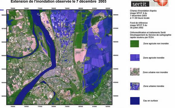
11 PROBA


")
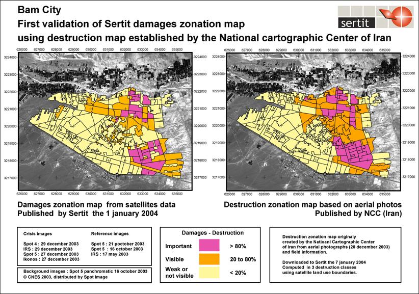
12 Bam earthquake, 26/12/ h58 GMT (5h28 local time) 6,6 Mw casualties

13 Bam earthquake, 26/12/03
: photo interpretation of IKONOS acquisition of")
14 Bam earthquake, 26/12/03 Products delivered to THW, Portuguese and French CP 30/12 : Damage map of Bam (DLR): photo interpretation of IKONOS acquisition of 27/12

15 Bam earthquake, 26/12/03 PROBA HRC 2 March 2004 Bam earthquake, 26/12/03

16 Bam earthquake, 26/12/03

17 December 2004 tsunami Chris and HRC acquisition over: Indonesia Maldives islands Nicobar islands


18 December 2004 tsunami Chris Nicobar islands Chris Indonesia

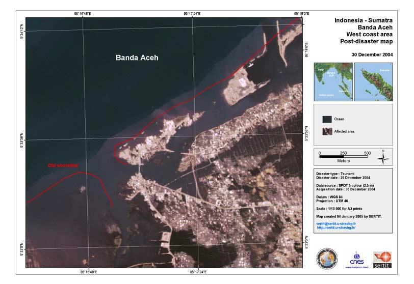
19 December 2004 tsunami 13 th of February images mosaic over Banda Aceh, Indonesia

20 December 2004 tsunami 3 HRC Proba images mosaic 14 th of February 2005 over Banda Aceh, Indonesia

21 December 2004 tsunami PROBA HRC 14 Feb 2005 over Banda Aceh, PROBA Indonesia HRC 14 Feb 2005 Banda Aceh
22
 were not")
23 Rarotonga cyclone case Damage map difficult to be dressed without VHR reference data, since «classical» VHR reference (SPOT 5, IRS) were not available
 not available HRC")

24 Potential for an exploitation of HRC and CHRIS archive Rarotonga case : «classical» VHR reference (SPOT 5, IRS) not available HRC Proba data would have been exploited if an automatic/systematic search within PROBA archive had been done. Rarotonga PROBA HRC

25 Zadran earthquake IRS exploitation


26 IRS reference image Texture analysis PROBA HRC 9 March 2005 Zadran earthquake, Iran, 22/02/2005
27 PROBA and the Charter Charter aims to a FAST DELIVERY to the E.U. of the PRODUCT : Space maps: geo-referenced image, with a cartographic (IGN) layer, on a user-known reference system. Required a few HOURS after the activation. Based on (recent) archive data Damage maps: result of an expert interpretation of detected changes between before (archives) & after (crisis acquisitions) data using a variety of sensors (SPOT, IRS, PROBA, IKONOS). A few days (3-4) delay after activation still acceptable.
28 Good POTENTIAL of PROBA for the Charter PROBA reactivity is good, though improvements are possible. Good results obtained for some Charter activations: - HRC Iran earthquake 2005 => 2 weeks - HRC and Chris Indonesia =>1 to 3 weeks (good) - HRC Bam, Iran => 3 months - CHRIS Arles floods 2003 => 4 days (very good) Difficulty in the case of HRC: very precise location information is needed a priori (planning), because of the reduced image size.
29 Good POTENTIAL of PROBA for the Charter 1 - CRISIS acquisition delivery: higher probability to obtain exploitable post-event HR data => Fast, all-time channel for planning of both instruments (HRC, CHRIS) at PM and ECO s request => NRT processing and transfer of data to PM shortly after acquisition 2 - Valorisation/exploitation of the archives HRC/Chris during Charter activations. Several exotic locations (islands in the Pacific or Indian ocean) covered by PROBA acquisitions => Requires a systematic search within HRC and CHRIS archive database after each Charter triggering Chris accessible through EOLI HRC soon accessible through EOLI (integration stage)
30 Good POTENTIAL of PROBA for the Charter PROBA 2 is scheduled for 2007 Desirable to take into account in the ground segment design, in an early stage, the Charter constraints, in terms of programmation and data production and delivery Thanks for your attention!
31 Validation

32 December 2004 tsunami
KARI Activation for the International Disasters
 KARI Activation for the International Disasters 5 th Joint Project Team Meeting for Sentinel Asia STEP2 (JPTM2012) 14 th Nov 2012 Boyeol Yoon Senior Researcher, Satellite Information Research Center (SIRC)
Earth Observation for Emergency Response and the International Charter on Space and Major Disasters.
 Earth Observation for Emergency Response and the International Charter on Space and Major Disasters. Case studies of the 2016 Alberta wildfires and 2017 Québec flooding Simon Tolszczuk-Leclerc 1, Brad
International Charter: Space and Major Disasters
 International Charter: Space and Major Disasters UNESCAP Training Workshop Kathmandu Nepal 30-31 Oct 2017 Dr. N K Shrivastava (shrivastava.nk@gmail.com) Former Charter Executive Secretariat Member Dy.
2017 Source of Foreign Income Earned By Fund
 2017 Source of Foreign Income Earned By Fund Putnam Emerging Markets Equity Fund EIN: 26-2670607 FYE: 08/31/2017 Statement Pursuant to 1.853-4: The fund is hereby electing to apply code section 853 for
Governments that have requested pre-export notifications pursuant to article 12, paragraph 10 (a), of the 1988 Convention
, of the 1988 Convention") Annex X Governments that have requested pre-export notifications pursuant to article 12, paragraph 10 (a), of the 1988 Convention 1. Governments of all exporting countries and territories are reminded
Annex X Governments that have requested pre-export notifications pursuant to article 12, paragraph 10 (a), of the 1988 Convention 1. Governments of all exporting countries and territories are reminded
The International Charter Space and Major Disasters is further strengthening its contribution to disaster management worldwide.
 28 September 2012 Issue 3 The International Charter Space and Major Disasters is further strengthening its contribution to disaster management worldwide. Building on a decade of success in making satellite
10 emergency observation requests were successfully processed during the period
 ISRO s Inputs for the Sentinel Asia DPN and JPT meeting being held during 13-16, 16, November 2012 November 2012 Sentinel Asia Activity Spectrum - A dedicated Sentinel Asia server established at NRSC,
SPACE TECHNOLOGY INSTITUTE, VNREDSat-1 and DATA PROVIDER NODE (DPN) REPORT
 REPORT") 4th Joint Project Team Meeting for Sentinel Asia STEP3 (JPTM2017) 8-9 March 2017 SPACE TECHNOLOGY INSTITUTE, VNREDSat-1 and DATA PROVIDER NODE (DPN) REPORT www.sti.vast.ac.vn CONTENT 1. Overview of Space
4th Joint Project Team Meeting for Sentinel Asia STEP3 (JPTM2017) 8-9 March 2017 SPACE TECHNOLOGY INSTITUTE, VNREDSat-1 and DATA PROVIDER NODE (DPN) REPORT www.sti.vast.ac.vn CONTENT 1. Overview of Space
About the Authors Geography and Tourism: The Attraction of Place p. 1 The Elements of Geography p. 2 Themes of Geography p. 4 Location: The Where of
 Preface p. ix About the Authors p. xi Geography and Tourism: The Attraction of Place p. 1 The Elements of Geography p. 2 Themes of Geography p. 4 Location: The Where of Geography p. 4 Place and Space:
1. Impacts of Natural Disasters by Region, 2008
 1. Impacts of Natural Disasters by Region, 2008 Among all regions across the world in 2008, Asia not only ranks first but also dominates in all natural disaster s impact categories occurrence, killed,
earth observation
 earth observation One of the major disasters that stands out in Charter activations was the December 2004 tsunami that caused immense devastation in coastal regions of India and Southeast Asia. A wide
Supplementary Appendix for. Version: February 3, 2014
 Supplementary Appendix for When Do Governments Resort to Election Violence? Version: February 3, 2014 This appendix provides supplementary information not included in the published draft. Supplementary
Theme 4. Disaster Mitigation and Risk Management
 Theme 4 Disaster Mitigation and Risk Management World Flood Map in 2002 Released by WMO as of August 29 Over 17 million were affected (in more than 80 countries) 3,000 were killed Total damage of over
Canadian Imports of Honey
 of 0409000029 - Honey, natural, in containers of a weight > 5 kg, nes (Kilogram) Argentina 236,716 663,087 2,160,216 761,990 35.27% 202.09% /0 76,819 212,038 717,834 257,569 35.88% 205.69% /0 United States
2018 REVIEW OF DISASTER EVENTS
 2018 REVIEW OF DISASTER EVENTS Supplementary Information* BRUSSELS, 24 January, 2019 In 2018, there were 281 climate-related and geophysical events recorded in the EM-DAT (International Disaster Database)
The ESA Earth observation programmes overview and outlook
 The ESA Earth observation programmes overview and outlook Dr. Volker Liebig Director, ESA EO Programmes ILA 2008, Berlin ENVISAT mission: 6 years! Bam earthquake Tectonic uplift (Andaman) Arctic 2007 First
Sentinel Asia Data Provider Node Report
 Sentinel Asia Data Provider Node Report Joint Project Team Meeting for Sentinel Asia STEP3 (JPTM2018) 23 24 January 2018, Taipei, Taiwan Yuji TAKADA Space Applications and Operations Center (SAOC) Japan
The DEIMOS Earth Observation System and the PanGeo Alliance. Contribution to CSCDA Data WareHouse 2. Fabrizio Pirondini CEO, Elecnor Deimos Imaging
 The DEIMOS Earth Observation System and the PanGeo Alliance Contribution to CSCDA Data WareHouse 2 Fabrizio Pirondini CEO, Elecnor Deimos Imaging Copernicus Space Component Data Access Workshop ESRIN,
Copernicus Today and Tomorrow GEO Week Group on Earth Observation Geneva, 16 January 2014 The Copernicus Space Infrastructure
 Copernicus Today and Tomorrow GEO Week Group on Earth Observation Geneva, 16 January 2014 The Copernicus Space Infrastructure Thomas Beer, Policy Coordinator, Copernicus Space Office, ESA-ESRIN, Frascati
GI Technology for Disaster Management
 GI Technology for Disaster Management 17 th ICC on the Regional Space Applications Programme for Sustainable Development (RESAP) 26 th Nov 2013 Bangkok Thailand Period and time of seasonal in thailand
RESAP Progress Report
 RESAP Progress Report December 2016 to October 2017 Presentation to the Twenty-first session of the Intergovernmental Consultative Committee on the Regional Space Applications Programme for Sustainable
Capacity Building in Applications of Remote Sensing and GIS for Disaster Management
 Capacity Building in Applications of Remote Sensing and GIS for Disaster Management M.K. Hazarika, L. Samarakoon, N. Senevirathne, J.S.M. Fowze and R. de Silva Project Researcher GeoInformatics Center
DISTILLED SPIRITS - IMPORTS BY VALUE DECEMBER 2017
 DISTILLED SPIRITS - IMPORTS BY VALUE DECEMBER 2017 U.S. DUTIABLE IMPORTS OF DISTILLED SPIRITS (U.S. DOLLARS) Ea-Value-17-12 SUMMARY: IMPORTS ENTERED FOR CONSUMPTION CLASS DECEMBER DECEMBER PERCENT JANUARY
DISTILLED SPIRITS - IMPORTS BY VOLUME DECEMBER 2017
 DISTILLED SPIRITS - IMPORTS BY VOLUME DECEMBER 2017 U.S. DUTIABLE IMPORTS OF DISTILLED SPIRITS (PROOF GALLONS) Ea-17-12 SUMMARY: IMPORTS ENTERED FOR CONSUMPTION CLASS DECEMBER DECEMBER PERCENT JANUARY
Bilateral Labour Agreements, 2004
 Guest Austria Canada Turkey ( 64) Canada, Czech Republic, Hungary ( 98), Belgium Italy ( 46, 54), Turkey ( 64) Bulgaria ( 99), Pol (02) Germany ( 91) Bulgaria ( 99), Mongolia ( 99), Pol ( 92), Russia (
SDG s and the role of Earth Observation
 SDG s and the role of Earth Observation Christian Heipke IPI - Institute for Photogrammetry and GeoInformation Leibniz Universität Hannover Germany Secretary General, ISPRS 1. No Poverty 2. Zero Hunger
Country of Citizenship, College-Wide - All Students, Fall 2014
 Country of Citizenship, College-Wide - All Students, Fall 2014-49,552 (72%) students were U.S. Citizens in Fall 2014. - MDC's non-citizen students come from at least 167 countries and speak approximately
DISTILLED SPIRITS - EXPORTS BY VALUE DECEMBER 2017
 DISTILLED SPIRITS - EXPORTS BY VALUE DECEMBER 2017 U.S. COMMERCIAL EXPORTS OF DISTILLED SPIRITS - DECEMBER 2017 (U.S. DOLLARS) Da-Value-17-12 SUMMARY BY CLASS CLASS DECEMBER DECEMBER DOLLAR YTD YTD DOLLAR
International Student Enrollment Fall 2018 By CIP Code, Country of Citizenship, and Education Level Harpur College of Arts and Sciences
 International Student Enrollment Fall 2018 By CIP Code, Country of Citizenship, and Education Level Harpur College of Arts and Sciences CIP Code Description Citizenship Graduate Undergrad Total 00.0000
Flood SensorWeb Dan Mandl / Fritz Policelli NASA/GSFC
 Flood SensorWeb Dan Mandl / Fritz Policelli NASA/GSFC 10-16-08 1 Purpose Vision of Flood Sensor Web Present status of Flood SensorWeb initiative Some relevant examples from Fire SensorWeb efforts Goal
PRECURSORS. Pseudoephedrine preparations 3,4-MDP-2-P a P-2-P b. Ephedrine
 ANNEXES Annex II Annual legitimate requirements for ephedrine, pseudoephedrine, 3,4-methylenedioxyphenyl-2-propanone and 1-phenyl-2-propanone, substances frequently used in the manufacture of amphetamine-type
Space-based technology and applications and space science for humanitarian affairs, environment and security
 Space-based technology and applications and space science for humanitarian affairs, environment and security LUC ST-PIERRE United Nations Office for Outer Space Affairs United Nations Office at Vienna
GINA Children. II Global Index for humanitarian Needs Assessment (GINA 2004) Sheet N V V VI VIII IX X XI XII XII HDR2003 HDR 2003 UNDP
 Sheet N V V VI VIII IX X XI XII XII HDR2003 HDR 2003 UNDP") Human UNICEF Index Index Natural 2003 GDP per Total as % of Total Rate HDI HPI Disasters Conflicts capita Population population 5 1 Congo, Democratic Republic of the 2,80000 3 3 1 3 3 3 3 3 3 3 2 Burundi
Human UNICEF Index Index Natural 2003 GDP per Total as % of Total Rate HDI HPI Disasters Conflicts capita Population population 5 1 Congo, Democratic Republic of the 2,80000 3 3 1 3 3 3 3 3 3 3 2 Burundi
EUMETSAT. A global operational satellite agency at the heart of Europe. Presentation for the Spanish Industry Day Madrid, 15 March 2012
 EUMETSAT A global operational satellite agency at the heart of Europe Presentation for the Spanish Industry Day Madrid, Angiolo Rolli EUMETSAT Director of Administration EUMETSAT objectives The primary
2,152,283. Japan 6,350,859 32,301 6,383,160 58,239, ,790 58,464,425 6,091, ,091,085 52,565, ,420 52,768,905
 Almond Industry Position Report APRIL 2018 2017-2018 Crop Year Salable Forecast Million Lbs. 2017-2018 08/01-04/30 Kernel Wt. 2016-2017 08/01-04/30 Kernel Wt. % Change 1. Carryin August 1, 2017 398.7 398,677,112
Grand Total Baccalaureate Post-Baccalaureate Masters Doctorate Professional Post-Professional
 s by Location of Permanent Home Address and Degree Level Louisiana Acadia 26 19 0 6 1 0 0 0 0 Allen 7 7 0 0 0 0 0 0 0 Ascension 275 241 3 23 1 6 0 1 0 Assumption 13 12 0 1 0 0 0 0 0 Avoyelles 15 11 0 3
USDA Dairy Import License Circular for 2018
 USDA Dairy Import License Circular for 2018 Commodity/Note Country Name TRQ Jan Feb Mar Apr May Jun Jul Aug Sep Oct Nov Grand Total Non-Cheese 21,864,781 624,064 651,121 432,669 901,074 1,202,567 907,493
Forecast Million Lbs. % Change 1. Carryin August 1, ,677, ,001, % 45.0
 Almond Industry Position Report DECEMBER 2017 2017-2018 Crop Year Salable Forecast Million Lbs. 2017-2018 08/01-12/31 Kernel Wt. 2016-2017 08/01-12/31 Kernel Wt. % Change 1. Carryin August 1, 2017 398.7
TMM UPDATE TRANS DAY OF REMEMBRANCE 2017
 TMM UPDATE TRANS DAY OF REMEMBRANCE 2017 2,609 reported murders of trans and gender-diverse people between 1 January 2008 and 30 September 2017 World Regions/Countries All regions Africa South Africa 1
Emergency Management Service (EMS) mapping
 mapping") GMES Emergency Management Service (EMS) mapping Frédéric BASTIDE GMES unit, European Commission UN-SPIDER Expert Meeting: "Crowdsource Mapping for Disaster Risk Management and Emergency Response" 3-5 December,
GMES Emergency Management Service (EMS) mapping Frédéric BASTIDE GMES unit, European Commission UN-SPIDER Expert Meeting: "Crowdsource Mapping for Disaster Risk Management and Emergency Response" 3-5 December,
READY TO SCRAP: HOW MANY VESSELS AT DEMOLITION VALUE?
 READY TO SCRAP: HOW MANY VESSELS AT DEMOLITION VALUE? August 206 VesselsValue Global number of vessels at demolition value At scrap value 7,27 6 Above scrap value,8 84 Number of vessels at demolition value
Natural Disasters in Member Countries (2002 Summary)
") 4.2 Member Countries and their Disaster Characteristics: Table 5: Natural Disasters in Member Countries (2002 Summary) (Country/Disaster Type/Disaster Characteristics) Data Country DisType Count of TotAff
4.2 Member Countries and their Disaster Characteristics: Table 5: Natural Disasters in Member Countries (2002 Summary) (Country/Disaster Type/Disaster Characteristics) Data Country DisType Count of TotAff
Do Policy-Related Shocks Affect Real Exchange Rates? An Empirical Analysis Using Sign Restrictions and a Penalty-Function Approach
 ISSN 1440-771X Australia Department of Econometrics and Business Statistics http://www.buseco.monash.edu.au/depts/ebs/pubs/wpapers/ Do Policy-Related Shocks Affect Real Exchange Rates? An Empirical Analysis
Office of Budget & Planning 311 Thomas Boyd Hall Baton Rouge, LA Telephone 225/ Fax 225/
 Louisiana Acadia 25 19 4 2 0 0 Allen 8 7 1 0 0 0 Ascension 173 143 26 1 0 3 Assumption 14 12 2 0 0 0 Avoyelles 51 41 9 0 0 1 Beauregard 18 14 3 0 0 1 Bienville 5 0 4 0 1 0 Bossier 28 27 0 1 0 0 Caddo 95
GEO-VIII November Geohazard Supersites and Natural Laboratories Progress Report. Document 9
 GEO-VIII 16-17 November 2011 Geohazard Supersites and Natural Laboratories Progress Report Document 9 This document is submitted to GEO-VIII for information. Geohazard Supersites and Natural Laboratories
Overview of Technical Advisory Missions
 Expert Group Meeting (EGM) on Georeferenced Information Systems for Disaster Risk Management (Geo-DRM) and sustaining the Community of Practice (COP) 23-25 April 2014 Bangkok Overview of Technical Advisory
 Page 1 of 5 Home research global climate enso effects Research Effects of El Niño on world weather Precipitation Temperature Tropical Cyclones El Niño affects the weather in large parts of the world. The
04 June Dim A W V Total. Total Laser Met
 4 June 218 Member State State as on 4 June 218 Acronyms are listed in the last page of this document. AUV Mass and Related Quantities Length PR T TF EM Mass Dens Pres F Torq Visc H Grav FF Dim A W V Total
The First International Symposium on Geo-information for Disaster Management (Gi4DM) Delft, The Netherlands, March 21-23, 2005
 Delft, The Netherlands, March 21-23, 2005") The First International Symposium on Geo-information for Disaster Management (Gi4DM) Delft, The Netherlands, March 21-23, 2005 Madison, US Report of the Symposium to the Annual Meeting of FIG Commission
The First International Symposium on Geo-information for Disaster Management (Gi4DM) Delft, The Netherlands, March 21-23, 2005 Madison, US Report of the Symposium to the Annual Meeting of FIG Commission
sentinel-2 COLOUR VISION FOR COPERNICUS
 sentinel-2 COLOUR VISION FOR COPERNICUS SATELLITES TO SERVE By providing a set of key information services for a wide range of practical applications, Europe s Copernicus programme is providing a step
GEOLOGICAL HAZARD MITIGATION STRATEGY IN INDONESIA
 GEOLOGICAL HAZARD MITIGATION STRATEGY IN INDONESIA Surono Head of Geological Agency presented in: The 2nd Global Summit of Research Institutes for Disaster Risk Reduction Kihada Hall, Uji Campus, Kyoto
The Outer Space Legal Regime and UN Register of Space Objects
 The Outer Space Legal Regime and UN Register of Space Objects ITU-R Symposium and Workshop on the Small Satellite Regulation and Communication Systems Prague, Czech Republic, 2-4 March 2015 Niklas Hedman
Briefing Notes for World Hydrography Day
 Briefing Notes for World Hydrography Day - 2017 Mapping our seas, oceans and waterways - more important than ever Purpose of World Hydrography Day In 2005, the General Assembly of the United Nations (UN)
OCTOBER Almond Industry Position Report Crop Year /01-10/31 Kernel Wt /01-10/31 Kernel Wt.
 Almond Industry Position Report OCTOBER 2018 2018-2019 Crop Year Salable Forecast Million Lbs. 2018-2019 08/01-10/31 Kernel Wt. 2017-2018 08/01-10/31 Kernel Wt. % Change 1. Carryin August 1, 2018 359.0
Big Data at BBVA Research using BigQuery
 Big Data at BBVA Research using BigQuery Tomasa Rodrigo June 2017 Google Cloud Next Click here to modify the style of the master title Summary 01 What is GDELT and how BigQuery helps us to exploit it 02
Does socio-economic indicator influent ICT variable? II. Method of data collection, Objective and data gathered
 Does socio-economic indicator influent ICT variable? I. Introduction This paper obtains a model of relationship between ICT indicator and macroeconomic indicator in a country. Modern economy paradigm assumes
2001 Environmental Sustainability Index
 2001 Environmental Sustainability Index Annex 6: Variable Descriptions and Data An Initiative of the Global Leaders of Tomorrow Environment Task Force, World Economic Forum Annual Meeting 2001 Davos, Switzerland
Florida's Refugee Population Statistical Report
 Florida's Refugee Population Statistical Report October 1 st, 2002 September 30 th, 2003 Courtesy of the US Coast Guard Prepared By: Florida Department of Children & Families Refugee Services State of
Crisis Management and Natural Disasters Overview of JRC operational or pre-operational activities A. Annunziato, D. Al-Khudhairy
 Papagayo, Costarica 3-4 November 2009 Security Science and The Americas 1 Joint Research Centre (JRC) Crisis Management and Natural Disasters Overview of JRC operational or pre-operational activities A.
Additional VEX Worlds 2019 Spot Allocations
 Overview VEX Worlds 2019 Spot s Qualifying spots for the VEX Robotics World Championship are calculated twice per year. On the following table, the number in the column is based on the number of teams
Global Data Catalog initiative Christophe Charpentier ArcGIS Content Product Manager
 Global Data Catalog initiative Christophe Charpentier ArcGIS Content Product Manager ccharpentier@esri.com We are in a global economy Global Economy Business and Operations are now global Strategic need
Global Map: A Tool for Disaster Mitigation for the Asia and Pacific Region
 Global Map: A Tool for Disaster Mitigation for the Asia and Pacific Region D. R. Fraser Taylor Chair, International Steering Committee for Global Mapping (ISCGM) fraser_taylor@carleton.ca www. 18 th United
Sentinel-1 Mission Status
 Sentinel-1 Mission Status Pierre Potin, Sentinel-1 Mission Manager, ESA Luca Martino, Technical Support Engineer, ESA... and the Sentinel-1 operations team PSTG SAR Coordination Working Group 14 December
AP Human Geography Summer Assignment
 P Human Geography Summer ssignment P Human Geography is not a traditional geography class. Instead of learning about the locations of physical and political features, this course focuses on the interactions
Kernel Wt. 593,190,150 1,218,046,237 1,811,236, ,364, ,826, ,191, Crop Year
 Almond Industry Position Report JULY 2016 2015-2016 Crop Year Salable Forecast Million Lbs. 2015-2016 8/1-7/31 Kernel Wt. 2014-2015 8/1-7/31 Kernel Wt. % Change 1. Carryin August 1, 2015 2. Crop Receipts
How Well Are Recessions and Recoveries Forecast? Prakash Loungani, Herman Stekler and Natalia Tamirisa
 How Well Are Recessions and Recoveries Forecast? Prakash Loungani, Herman Stekler and Natalia Tamirisa 1 Outline Focus of the study Data Dispersion and forecast errors during turning points Testing efficiency
UN COPUOS 52 nd session of the Scientific and Technical Subcommittee. COPERNICUS - an European Achievement. S. Jutz Head, ESA Copernicus Space Office
 UN COPUOS 52 nd session of the Scientific and Technical Subcommittee COPERNICUS - an European Achievement S. Jutz Head, ESA Copernicus Space Office 11 Feb 2015, Vienna 1 2 What is Copernicus? European
Satellite Meteorology. Protecting Life and Property Around the World
 Satellite Meteorology Protecting Life and Property Around the World The Value of Forecasting Severe Weather Flooding events across Europe in August 2002 cost in the region of 20 billion; 20,000 people
Publication Date: 15 Jan 2015 Effective Date: 12 Jan 2015 Addendum 6 to the CRI Technical Report (Version: 2014, Update 1)
") Publication Date: 15 Jan 2015 Effective Date: 12 Jan 2015 This document updates the Technical Report (Version: 2014, Update 1) and details (1) Replacement of interest rates, (2) CRI coverage expansion,
Publication Date: 15 Jan 2015 Effective Date: 12 Jan 2015 This document updates the Technical Report (Version: 2014, Update 1) and details (1) Replacement of interest rates, (2) CRI coverage expansion,
Stochastic Analysis and Forecasts of the Patterns of Speed, Acceleration, and Levels of Material Stock Accumulation in Society
 Stochastic Analysis and Forecasts of the Patterns of Speed, Acceleration, and Levels of Material Stock Accumulation in Society Supporting information Tomer Fishman a,*, Heinz Schandl a,b, and Hiroki Tanikawa
Situation on the death penalty in the world. UNGA Vote 2012 Resolutio n 67/176. UNGA Vote 2010 Resolutio n 65/206. UNGA Vote 2008 Resolutio n 63/168
 Situation on the death penalty in the world Prepared by the International Commission against the Death Penalty (ICDP), as of 8 June 2014. Based on Amnesty International and Death Penalty Worldwide. Country
EMERGENCY. User Awareness & Training: Bucharest, Romania 8 th November 2013 Agata Priolo
 This presentation includes material courtesy of DG ENTR and DG JRC User Awareness & Training: EMERGENCY Bucharest, Romania 8 th November 2013 Agata Priolo Content Module 1: INTRODUCTION to GIO EMS Services
USDA Dairy Import License Circular for 2018
 USDA Dairy Import License Circular for 2018 Commodity/Note Country Name TRQ Jan Feb Mar Apr May Jun Grand Total Non-Cheese 21,864,781 624,064 651,121 432,669 901,074 1,202,567 907,493 4,718,988 BUTTER
Geohazard Supersites and Natural Laboratories
 Geohazard Supersites and Natural Laboratories FRINGE 2011, Frascati, Italy, September 19, 2011 Wolfgang Lengert, ESA Falk Amelung, University of Miami, GEO task lead Craig Dobson, NASA, CEOS task lead
International and regional network status
 WORLD METEOROLOGICAL ORGANIZATION JOINT MEETING OF CBS EXPERT TEAM ON SURFACE-BASED REMOTELY- SENSED OBSERVATIONS (Second Session) AND CIMO EXPERT TEAM ON OPERATIONAL REMOTE SENSING (First Session) CBS/ET-SBRSO-2
Chapter 1 Climate in 2016
 Chapter 1 Climate in 2016 1.1 Global climate summary Extremely high temperatures were frequently observed in many regions of the world, and in particular continued for most of the year in various places
sentinel-3 A BIGGER PICTURE FOR COPERNICUS
 sentinel-3 A BIGGER PICTURE FOR COPERNICUS SATELLITES TO SERVE By providing a set of key information services for a wide range of practical applications, Europe s Copernicus programme has been put in place
Appendices. Please note that Internet resources are of a time-sensitive nature and URL addresses may often change or be deleted.
 Appendices Appendix A Table of Treaties Appendix B State Trademark Registration Provisions Appendix C Resources Appendix D Forms Appendix Appendix E Selected Statutes Please note that Internet resources
Securing EUMETSAT s Mission from an Evolving Space Environment
 Securing EUMETSAT s Mission from an Evolving Space Environment ESPI 12 th Autumn Conference Andrew Monham 1 EUMETSAT: Intergovernmental Organisation of 30 Member States Presentation Contents AUSTRIA BELGIU
Radiation Protection Procedures
 S A F E T Y S E R IE S N o. 38 Radiation Protection Procedures IN T E R N A T IO N A L A T O M IC E N E R G Y A G E N C Y, V IEN N A, 1973 R A D I A T I O N P R O T E C T I O N P R O C E D U R E S The
Forecast Million Lbs. % Change 1. Carryin August 1, ,677, ,001, % 45.0
 Almond Industry Position Report NOVEMBER 2017 2017-2018 Crop Year Salable Forecast Million Lbs. 2017-2018 08/01-11/30 Kernel Wt. 2016-2017 08/01-11/30 Kernel Wt. % Change 1. Carryin August 1, 2017 398.7
Using Remote Sensing Technologies to Improve Resilience
 4 Using Remote Sensing Technologies to Improve Resilience Ronald T. Eguchi CEO, ImageCat, Inc. 6 years ago The world had just survived the Y2K bug with no major incidents Nations around the world commit
Natural Resource Management Indicators for the Least Developed Countries
 Natural Resource Management Indicators for the Least Developed Countries Alex de Sherbinin CIESIN, Columbia University 24 June 2005 Millennium Challenge Corporation workshop Brookings Institution Washington,
Challenges for the operational assimilation of satellite image data in agrometeorological models
 Challenges for the operational assimilation of satellite image data in agrometeorological models Mark Danson Centre for Environmental Systems Research, University of Salford, UK 0 Objectives The main objective
South, Southeast, and East Asia. Physical Geography
 South, Southeast, and East Asia Physical Geography Mountains v Mountains are important in Asia because they influence: A. Population patterns B. Movement of people and goods C. Climate Mountains v The
AND THE COOPERATION WITH SENTINEL ASIA FOR DISASTER MANAGEMENT
 Ministry of Natural resources and Environment National Remote Sensing DEpartment NATIONAL REMOTE SENSING DEPARTMENT (NRSD) AND THE COOPERATION WITH SENTINEL ASIA FOR DISASTER MANAGEMENT By: Dr. Chu Hai
Copernicus Overview and Emergency Management Service
 Copernicus Overview and Emergency Management Service Frédéric BASTIDE European Commission Open informal session of the United Nations Inter-Agency Meeting on Outer Space Activities 12 March 2013, Geneva
CEOS Support to the Geohazard Supersites
 The CEOS Supersite Coordination Team: Simona Zoffoli, ASI Steven Hosford, CNES Christine Giguère, CSA Jörn Hoffmann, DLR (Chair) Wolfgang Lengert, ESA Kazuo Umezawa, JAXA Shizu Yabe, JAXA Francis Lindsay,
The Indian Ocean. Copyright 2010 LessonSnips
 The Indian Ocean One of the five major geographic divisions of the world s ocean, the Indian Ocean is located in the Eastern Hemisphere. The Indian Ocean is bounded by three continents: Africa to the west,
PROPOSED BUDGET FOR THE PROGRAMME OF WORK OF THE CONVENTION ON BIOLOGICAL DIVERSITY FOR THE BIENNIUM Corrigendum
 CBD Distr. GENERAL UNEP/CBD/COP/11/10/Corr.1 6 October ORIGINAL: ENGLISH CONFERENCE OF THE PARTIES TO THE CONVENTION ON BIOLOGICAL DIVERSITY Eleventh meeting Hyderabad, India, 8-19 October Item 14.2 of
Data Provider Node Report ( JAXA )
") Data Provider Node Report ( JAXA ) Atsushi Ono, Secretariat, Sentinel Asia Disaster Management Support Systems Office Satellite Applications & Promotion Center Space Applications Mission Directorate Japan
Data Provider Node Report ( JAXA ) Atsushi Ono, Secretariat, Sentinel Asia Disaster Management Support Systems Office Satellite Applications & Promotion Center Space Applications Mission Directorate Japan
Table ronde 5 : Cartographie d'urgence Emergency Mapping.
 Table ronde 5 : Cartographie d'urgence Emergency Mapping MapAction is an international NGO that provides maps and other information services to help humanitarian relief organisations in the field MapAction
Solow model: Convergence
 Solow model: Convergence Per capita income k(0)>k* Assume same s, δ, & n, but no technical progress y* k(0)=k* k(0) k Assume same s, δ, &
Space Applications for Disaster Risk Reduction and Sustainable Development
 Space Applications for Disaster Risk Reduction and Sustainable Development Space Applications Section (SAS) ICT and Disaster Risk Reduction Division (IDD) UNESCAP Contents I. RESAP Activities 2016-2017
NGIAs' roles in successful disaster response
 The Second UN-GGIM-AP Plenary Meeting NGIAs' roles in successful disaster response Japan Teheran Iran 28 October 2013 Shin-ichi SAKABE, Director of International Affairs Division Geospatial Information
A long-term global forecast for the extraction of oil and gas from shale formations
 A long-term global forecast for the extraction of oil and gas from shale formations Finding Petroleum, London, 10/10/2012 Per Magnus Nysveen Rystad Energy This document is the property of Rystad Energy.
ia PU BLi s g C o M Pa K T Wa i n CD-1576
 M h M y CD-1576 o M Pa g C n ar ia PU BLi s in K T Wa i n ed National Geography Standards National Geography Standards Teachers leading discussions while completing units and activities is a prerequisite
Indian Earth Observation Programme
 Indian Earth Observation Programme Dr. Jai Singh Parihar Dy. Director Remote Sensing Applications Area (RESA) Space Applications Centre (ISRO) Ahmedabad 380 015 India jsparihar@sac.isro.gov.in Presentation
ENHANCING COMMITMENTS TO DISASTER PREPAREDNESS AND RESILIENCE OF PEOPLE WITH DISABILITIES
 ENHANCING COMMITMENTS TO DISASTER PREPAREDNESS AND RESILIENCE OF PEOPLE WITH DISABILITIES Global Risk Forum GRF Davos www.grforum.org Global Risk Forum GRF Davos Disasters Conflicts Natural Hazards Anthropogenic
The Regional Integrated Multi-Hazard Early Warning System for Africa and Asia CAP in RIMES
 The Regional Integrated Multi-Hazard Early Warning System for Africa and Asia CAP in RIMES 2018 CAP Implementation Workshop OUTLINE 1. RIMES Overview 2. DSS tools developed in RIMES 3. CAP Integration