Climate Information for Managing Risk. Victor Murphy NWS Southern Region Climate Service Program Mgr. June 12, 2008
|
|
|
- Elinor Hudson
- 5 years ago
- Views:
Transcription
1 Climate Information for Managing Risk Victor Murphy Climate Service Program Mgr. June 12, 2008

2 Currently From Fort Worth, TX
3 but climate challenges abound everywhere

4 as does the need to mitigate impacts and improve resiliency by providing decision makers with timely info in user friendly formats.
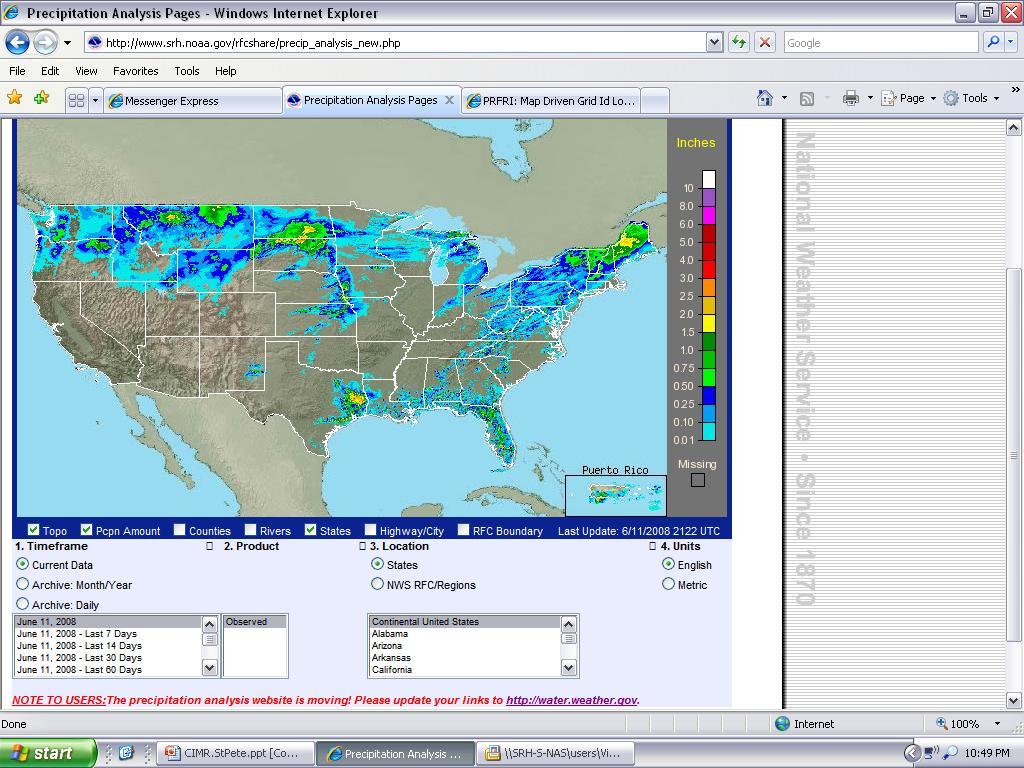
5 NWS Precipitation Analysis Precipitation variability is one of the key challenges to defining climate variability. Info must be accurate and timely and displayed in a format that is user friendly for decision makers to declare droughts or burn bans or disaster declarations when compared to climatological norms.

6 ...however.at the same time the needs of researchers and the climate application community must be met.
7 NWS Precipitation Analysis Product


8 Precipitation Analysis Product Many user groups are interested in high quality precipitation estimates with proper spatial resolution.
9 Precipitation Analysis Product Measuring and displaying observed precipitation amounts in a user friendly format is a fundamental precept of any kind of climate application. Accurate Precipitation Analysis or Estimates must follow a multi sensor approach. Individually, each method of determining precipitation totals has its inherent weaknesses.
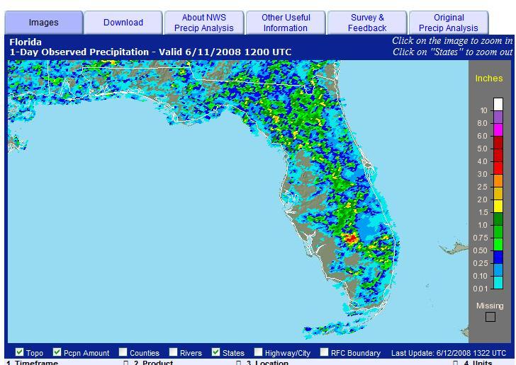
 Frozen Precip Electronic signal malfunctions Mechanical problems Bird Nests/blockages Timing and Coding")
10 Precipitation Analysis Product In situ gauge problems include: Wind Tipping bucket losses Siting (blockage from buildings, trees, plants) Frozen Precip Electronic signal malfunctions Mechanical problems Bird Nests/blockages Timing and Coding Issues
11 Precipitation Analysis Product In situ gauges also suffer from lack of spatial resolution or coverage. Even the most ambitious of mesonets will be fortunate to have one precipitation reporting site per county.

12 NWS Co-Op Data Sites in Alachua County

13 969 square miles two official reporting sites
 from raindrops and is called reflectivity Z A relationship assigns a rainfall rate R to the reflectivity Z")
14 NWS Doppler Radars Offer Spatial Density Brief explanation of how radar estimates rainfall Radar sends out beam of electromagnetic energy A small amount of this energy returns to the radar (measured in decibels or dbz) from raindrops and is called reflectivity Z A relationship assigns a rainfall rate R to the reflectivity Z (Z/R)

15 Precipitation Analysis Product
16 Precipitation Analysis Product We run a program called Multi Sensor Precip Estimator (MPE) every hour. We bias radar data using hourly rain gauges. After all the biases are checked, all the rain gauges have been quality controlled, all the AP has been removed, we save that hours estimates. This becomes our Best Estimate field. But remember these are still estimates. How do we know if they are close?

17 Precipitation Analysis Product We zoom in on an area of interest and display the 24-hour COOP and CoCoRaHS rain gauge data. We consider the 24-hour quality controlled (or manually read) rain gauge data to be our best.

18 Precipitation Analysis Product We can click on any of the rain gauges to show the precip data site. It tells us what the rain gauge value is, what the MPE value is at the location of the gauge, and the MPE value where we clicked our cursor.
 and rain gauge")
19 Precipitation Analysis Product Direct comparisons can now be made between what we estimated the rain to be (based on biased radar from MPE) and rain gauge data.
20 Precipitation Analysis Product Thru the use of hourly MPE, precipitation values are calculated nationally using 4km x 4km grids. These 4km x 4km grids are then added together to create a daily 24 hourly precipitation estimate valid at 1200GMT. They are stored in net.cdf files allowing external users to download the files for local applications.
21 Precipitation Analysis Product The precipitation value assigned to each grid is the centroid location when shipped via a net.cdf file. 24 hour values can then be summed to create user selectable daily, weekly, 2 week, monthly, etc., products. Value added products include departures from normal and percent of normal precipitation using PRISM derived data as the normal data set.
22 Precipitation Analysis Product Users have a GIS format method for selecting the time frame, region of the country, or state for which they want to view the data. User selectable parameters include counties, cities, major highways, and rivers.
23 Precipitation Analysis Product Historical data currently goes back to Emphasis on taking this back earlier. Initial product available at approx 1400GMT daily. Final product available at approx 1900GMT daily.
24
25 Day 1 Precipitation
26 May 2008 Observed Precip

27 PRISM derived 30 day normal precipitation

28 May 2008 Departure from Normal

29 May 2008 % of Normal
30 Iowa 30 day Precipitation

31 Iowa 30 day departures

32 4km resolution of the KBDI in Florida

33 County Average KBDI for Florida

34 4km x 4km KBDI

35 Alabama Lawn/Garden Moisture Index
36 Thank You! Victor Murphy x 130
The Hydrologic Cycle: How Do River Forecast Centers Measure the Parts?
 The Hydrologic Cycle: How Do River Forecast Centers Measure the Parts? Greg Story Meteorologist National Weather Service Fort Worth, TX Overview n Introduction What is the mission of an RFC? n The Hydrologic
National Weather Service Flood Forecast Needs: Improved Rainfall Estimates
 National Weather Service Flood Forecast Needs: Improved Rainfall Estimates Weather Forecast Offices Cleveland and Northern Indiana Ohio River Forecast Center Presenter: Sarah Jamison, Service Hydrologist
Multi-Sensor Precipitation Reanalysis
 Multi-Sensor Precipitation Reanalysis Brian R. Nelson, Dongsoo Kim, and John J. Bates NOAA National Climatic Data Center, Asheville, North Carolina D.J. Seo NOAA NWS Office of Hydrologic Development, Silver
Observations from Plant City Municipal Airport during the time period of interest are summarized below:
 December 3, 2014 James A. Murman Barr, Murman & Tonelli 201 East Kennedy Boulevard Suite 1700 Tampa, FL 33602 RE: Case No. 166221; BMT Matter No.: 001.001007 Location of Interest: 1101 Victoria Street,
Understanding Weather and Climate Risk. Matthew Perry Sharing an Uncertain World Conference The Geological Society, 13 July 2017
 Understanding Weather and Climate Risk Matthew Perry Sharing an Uncertain World Conference The Geological Society, 13 July 2017 What is risk in a weather and climate context? Hazard: something with the
NWS SERFC Hydrologic Vulnerability Assessment. Monday, March 9 th, 2015 NOAA, National Weather Service Southeast River Forecast Center
 NWS SERFC Hydrologic Vulnerability Assessment Monday, March 9 th, 2015 NOAA, National Weather Service Southeast River Forecast Center Current Weather Map Today s weather map shows a blossoming system in
Brian R. Nelson, Dongsoo Kim, and John J. Bates NOAA National Climatic Data Center, Asheville, North Carolina
 4.6 MULTI-SENSOR PRECIPITATION REANALYSIS Brian R. Nelson, Dongsoo Kim, and John J. Bates NOAA National Climatic Data Center, Asheville, North Carolina D.J. Seo NOAA NWS Office of Hydrologic Development,
GIS Tools, Data, & Methods in the Weekly US Drought Monitor
 GIS Tools, Data, & Methods in the Weekly US Drought Monitor International Workshop on Agromet and GIS Applications for Agricultural Decision Making Jeju, South Korea December 5, 2016 Eric Luebehusen USDA/OCE/WAOB
High Resolution Indicators for Local Drought Monitoring
 High Resolution Indicators for Local Drought Monitoring REBECCA CUMBIE, STATE CLIMATE OFFICE OF NC, NCSU Monitoring Drought Multiple indicators, multiple sources Local detail important 1 Point-Based Climate-Division
Improving Reservoir Management Using the Storm Precipitation Analysis System (SPAS) and NEXRAD Weather Radar
 and NEXRAD Weather Radar") Improving Reservoir Management Using the Storm Precipitation Analysis System (SPAS) and NEXRAD Weather Radar Bill D. Kappel, Applied Weather Associates, LLC, Monument, CO Edward M. Tomlinson, Ph.D., Applied
Improving Reservoir Management Using the Storm Precipitation Analysis System (SPAS) and NEXRAD Weather Radar Bill D. Kappel, Applied Weather Associates, LLC, Monument, CO Edward M. Tomlinson, Ph.D., Applied
REQUIREMENTS FOR WEATHER RADAR DATA. Review of the current and likely future hydrological requirements for Weather Radar data
 WORLD METEOROLOGICAL ORGANIZATION COMMISSION FOR BASIC SYSTEMS OPEN PROGRAMME AREA GROUP ON INTEGRATED OBSERVING SYSTEMS WORKSHOP ON RADAR DATA EXCHANGE EXETER, UK, 24-26 APRIL 2013 CBS/OPAG-IOS/WxR_EXCHANGE/2.3
Spatial Optimization of CoCoRAHS Network in Tennessee. Joanne Logan Department of Biosystems Engineering and Soil Science University of Tennessee
 Spatial Optimization of CoCoRAHS Network in Tennessee Joanne Logan Department of Biosystems Engineering and Soil Science University of Tennessee Abstract CoCoRaHS (Community Collaborative Rain, Hail and
Using Independent NCDC Gauges to Analyze Precipitation Values from the OneRain Corporation Algorithm and the National Weather Service Procedure
 Using Independent NCDC Gauges to Analyze Precipitation Values from the OneRain Corporation Algorithm and the National Weather Service Procedure Steven M. Martinaitis iti Henry E. Fuelberg John L. Sullivan
2.12 Inter-Comparison of Real-Time Rain Gage and Radar-Estimated Rainfall on a Monthly Basis for Midwestern United States Counties
 2.12 Inter-Comparison of Real-Time Rain and -Estimated Rainfall on a Monthly Basis for Midwestern United States Counties Nancy Westcott* and Kenneth E. Kunkel Illinois State Water Survey Champaign, Illinois
CLIMATE CHANGE ADAPTATION BY MEANS OF PUBLIC PRIVATE PARTNERSHIP TO ESTABLISH EARLY WARNING SYSTEM
 CLIMATE CHANGE ADAPTATION BY MEANS OF PUBLIC PRIVATE PARTNERSHIP TO ESTABLISH EARLY WARNING SYSTEM By: Dr Mamadou Lamine BAH, National Director Direction Nationale de la Meteorologie (DNM), Guinea President,
Robert Shedd Northeast River Forecast Center National Weather Service Taunton, Massachusetts, USA
 Robert Shedd Northeast River Forecast Center National Weather Service Taunton, Massachusetts, USA Outline River Forecast Centers FEWS Implementation Status Forcing Data Ensemble Forecasting The Northeast
Model Calibration and Forecast Error for NFIE-Hydro
 Corey Van Dyk C E 397 Flood Forecasting 5/8/15 Model Calibration and Forecast Error for NFIE-Hydro Introduction The forecasting component of the National Flood Interoperability Experiment (NFIE), like
Volume 8, Number 7, April 2018
 Volume 8, Number 7, April 2018 As we have previously noted (more than once), Alabama s tor- Let s talk about record-breaking weather. By now you might have heard that a large hailstone that fell in Cullman
Drought Update May 11, 2018
 Drought Update May 11, 2018 Current status After a record cold April, May has started with much warmer than normal temperatures. The statewide average temperature for the week ending on May 8th was 65.7
Areal Reduction Factors for the Colorado Front Range and Analysis of the September 2013 Colorado Storm
 Areal Reduction Factors for the Colorado Front Range and Analysis of the September 2013 Colorado Storm Doug Hultstrand, Bill Kappel, Geoff Muhlestein Applied Weather Associates, LLC - Monument, Colorado
Ed Tomlinson, PhD Bill Kappel Applied Weather Associates LLC. Tye Parzybok Metstat Inc. Bryan Rappolt Genesis Weather Solutions LLC
 Use of NEXRAD Weather Radar Data with the Storm Precipitation Analysis System (SPAS) to Provide High Spatial Resolution Hourly Rainfall Analyses for Runoff Model Calibration and Validation Ed Tomlinson,
Amita Mehta and Ana Prados
 Building Capacity in Utilizing NASA Remote Sensing Observations in SWAT for Water Resources and Agricultural Management Applications Amita Mehta and Ana Prados NASA - University of Maryland Baltimore County
A new mesoscale NWP system for Australia
 A new mesoscale NWP system for Australia www.cawcr.gov.au Peter Steinle on behalf of : Earth System Modelling (ESM) and Weather&Environmental Prediction (WEP) Research Programs, CAWCR Data Assimilation
Gridding of precipitation and air temperature observations in Belgium. Michel Journée Royal Meteorological Institute of Belgium (RMI)
") Gridding of precipitation and air temperature observations in Belgium Michel Journée Royal Meteorological Institute of Belgium (RMI) Gridding of meteorological data A variety of hydrologic, ecological,
Gridding of precipitation and air temperature observations in Belgium Michel Journée Royal Meteorological Institute of Belgium (RMI) Gridding of meteorological data A variety of hydrologic, ecological,
Transboundary water management with Remote Sensing. Oluf Jessen DHI Head of Projects, Water Resources Technical overview
 Transboundary water management with Remote Sensing Oluf Jessen DHI Head of Projects, Water Resources Technical overview ozj@dhigroup.com Transboundary water management Water management across national
CoCoRaHS Monitoring Colorado s s Water Resources through Community Collaborations
 CoCoRaHS Monitoring Colorado s s Water Resources through Community Collaborations Nolan Doesken Colorado Climate Center Atmospheric Science Department Colorado State University Presented at Sustaining
Christopher ISU
 Christopher Anderson @ ISU Excessive spring rain will be more frequent (except this year). Will it be more manageable? Christopher J. Anderson, PhD 89th Annual Soil Management and Land Valuation Conference
New Forecast Section. connection. Volume 3 Issue 4 April 2012
 Volume 3 Issue 4 April 2012 connection www.mesonet.org New Forecast Section Spring has arrived, and so has storm season. For many, that means monitoring the weather and forecast more. To help users prepare
CoCoRaHS. Community Collaborative Rain, Hail, & Snow Network. Ashley Wolf Meteorologist NWS Green Bay Northeast Wisconsin CoCoRaHS Coordinator
 CoCoRaHS Community Collaborative Rain, Hail, & Snow Network Ashley Wolf Meteorologist NWS Green Bay Northeast Wisconsin CoCoRaHS Coordinator What is CoCoRaHS Who, What, Where and Whys of CoCoRaHS What?
What Can Citizen Scientists Tell Us about Drought?
 What Can Citizen Scientists Tell Us about Drought? Using CoCoRaHS to Improve the Monitoring and Reporting of Drought Impacts Amanda Farris, Kirsten Lackstrom Carolinas Integrated Sciences & Assessments
Applications/Users for Improved S2S Forecasts
 Applications/Users for Improved S2S Forecasts Nolan Doesken Colorado Climate Center Colorado State University WSWC Precipitation Forecasting Workshop June 7-9, 2016 San Diego, CA First -- A short background
Detailed Storm Rainfall Analysis for Hurricane Ivan Flooding in Georgia Using the Storm Precipitation Analysis System (SPAS) and NEXRAD Weather Radar
 and NEXRAD Weather Radar") Detailed Storm Rainfall Analysis for Hurricane Ivan Flooding in Georgia Using the Storm Precipitation Analysis System (SPAS) and NEXRAD Weather Radar Ed Tomlinson, PhD and Bill Kappel Applied Weather Associates
Detailed Storm Rainfall Analysis for Hurricane Ivan Flooding in Georgia Using the Storm Precipitation Analysis System (SPAS) and NEXRAD Weather Radar Ed Tomlinson, PhD and Bill Kappel Applied Weather Associates
NIDIS Remote Sensing Workshop: Showcase of Products & Technologies
 Feature Article From Intermountain West Climate Summary, April 2008 NIDIS Remote Sensing Workshop: Showcase of Products & Technologies By Christina Alvord of WWA Three knowledge assessment workshops are
The History and Making of the U.S. Drought Monitor
 The History and Making of the U.S. Drought Monitor Mike Hayes, Director Mark Svoboda, Climatologist/Monitoring Program Area Leader Kelly Smith, Communications Specialist National Drought Mitigation Center
Regional Drought Decision Support System (RDDSS) Project Update and Product Concepts
 Project Update and Product Concepts") Regional Drought Decision Support System (RDDSS) Project Update and Product Concepts Part of the Red River Basin Decision Information Network (RRBDIN) NEXT-GEN RRBDIN Decision Support for the Red River
Regional Drought Decision Support System (RDDSS) Project Update and Product Concepts Part of the Red River Basin Decision Information Network (RRBDIN) NEXT-GEN RRBDIN Decision Support for the Red River
At the start of the talk will be a trivia question. Be prepared to write your answer.
 Operational hydrometeorological forecasting activities of the Australian Bureau of Meteorology Thomas Pagano At the start of the talk will be a trivia question. Be prepared to write your answer. http://scottbridle.com/
2003 Water Year Wrap-Up and Look Ahead
 2003 Water Year Wrap-Up and Look Ahead Nolan Doesken Colorado Climate Center Prepared by Odie Bliss http://ccc.atmos.colostate.edu Colorado Average Annual Precipitation Map South Platte Average Precipitation
Lecture 6: Precipitation Averages and Interception
 Lecture 6: Precipitation Averages and Interception Key Questions 1. How much and when does Whatcom County receive rain? 2. Where online can you find rainfall data for the state? 3. How is rainfall averaged
Development of High Resolution Gridded Dew Point Data from Regional Networks
 Development of High Resolution Gridded Dew Point Data from Regional Networks North Central Climate Science Center Open Science Conference May 20, 2015 Ruben Behnke Numerical Terradynamic Simulation Group
120 ASSESMENT OF MULTISENSOR QUANTITATIVE PRECIPITATION ESTIMATION IN THE RUSSIAN RIVER BASIN
 120 ASSESMENT OF MULTISENSOR QUANTITATIVE PRECIPITATION ESTIMATION IN THE RUSSIAN RIVER BASIN 1 Delbert Willie *, 1 Haonan Chen, 1 V. Chandrasekar 2 Robert Cifelli, 3 Carroll Campbell 3 David Reynolds
NIDIS Intermountain West Drought Early Warning System July 18, 2017
 NIDIS Drought and Water Assessment NIDIS Intermountain West Drought Early Warning System July 18, 2017 Precipitation The images above use daily precipitation statistics from NWS COOP, CoCoRaHS, and CoAgMet
data using low-cost measurement tools 4-inch diameter high capacity rain gauges
 Utah Rain Training Rain Because every drop counts! What Is CoCoRaHS? CoCoRaHS is a grassroots, non-profit, community-based, high-density h it precipitation it ti network made up of volunteers of all backgrounds
CoCoRaHS and the Drought Monitor (Help us help you!) Colorado Climate Center
 Colorado Climate Center") CoCoRaHS and the Drought Monitor (Help us help you!) Colorado Climate Center Anybody bring a rain gauge?! A sight for sore eyes The Community Collaborative Rain, Hail, and Snow (CoCoRaHS) networks is a
CoCoRaHS and the Drought Monitor (Help us help you!) Colorado Climate Center Anybody bring a rain gauge?! A sight for sore eyes The Community Collaborative Rain, Hail, and Snow (CoCoRaHS) networks is a
June 17, 2015 Lab Exercise
 June 17, 2015 Lab Exercise Objective: To become comfortable with: Interpreting heavy rainfall forecast products and ingredients before an event (Part 1) Monitoring key heavy rainfall products during an
National Weather Service Greenville-Spartanburg, Forecast Office
 National Weather Service Greenville-Spartanburg, Forecast Office CoCoRaHS Presentation: NC CERT Conference May, 2017 Introduction- who we are. Federal Agency Within the U.S. Dept. of Commerce Introduction-
Climate Prediction Center National Centers for Environmental Prediction
 NOAA s Climate Prediction Center Climate Monitoring Tool Wassila M. Thiaw and CPC International Team Climate Prediction Center National Centers for Environmental Prediction CPC International Team Vadlamani
Use of Seasonal forecasts in Electrical Load Prediction
 Use of Seasonal forecasts in Electrical Load Prediction Tina Greenfield Eric Aligo Linda Mudoni Iowa State University Department of Geological and Atmospheric Sciences May 2, 22 1 1. Introduction The electricity
NIDIS Intermountain West Drought Early Warning System August 8, 2017
 NIDIS Drought and Water Assessment 8/8/17, 4:43 PM NIDIS Intermountain West Drought Early Warning System August 8, 2017 Precipitation The images above use daily precipitation statistics from NWS COOP,
Impact on Agriculture
 Weather Variability and the Impact on Agriculture InfoAg 2017 Copyright 2017, awhere. All Rights Reserved The Problem: The Earth s Atmosphere is a Heat Engine In transition 1 C warming of atmosphere Triples
Using the EartH2Observe data portal to analyse drought indicators. Lesson 4: Using Python Notebook to access and process data
 Using the EartH2Observe data portal to analyse drought indicators Lesson 4: Using Python Notebook to access and process data Preface In this fourth lesson you will again work with the Water Cycle Integrator
*Corresponding author address: Charles Barrere, Weather Decision Technologies, 1818 W Lindsey St, Norman, OK
 P13R.11 Hydrometeorological Decision Support System for the Lower Colorado River Authority *Charles A. Barrere, Jr. 1, Michael D. Eilts 1, and Beth Clarke 2 1 Weather Decision Technologies, Inc. Norman,
Funding provided by NOAA Sectoral Applications Research Project MONITORING DROUGHT. Basic Climatology Colorado Climate Center
 Funding provided by NOAA Sectoral Applications Research Project MONITORING DROUGHT Basic Climatology Colorado Climate Center DEFINING DROUGHT First off, just what is drought? Define a tornado Define a
Regional Flash Flood Guidance and Early Warning System
 WMO Training for Trainers Workshop on Integrated approach to flash flood and flood risk management 24-28 October 2010 Kathmandu, Nepal Regional Flash Flood Guidance and Early Warning System Dr. W. E. Grabs
Weather can change quickly...are you on top of the changes?
 Weather Access Bob Glancy NOAA National Weather Service, Boulder, CO Near Cedar Point, CO May 9, 2004 Weather can change quickly...are you on top of the changes? National Weather Service Local offices:
The U.S. Drought Monitor: A Composite Indicator Approach
 The U.S. Drought Monitor: A Composite Indicator Approach Mark Svoboda, Climatologist Monitoring Program Area Leader National Drought Mitigation Center University of Nebraska-Lincoln NWS IN Climate Services
New Concept of Regional Cooperation in Asia for Water Disaster Management Applying Satellite Precipitation Measurement
 New Concept of Regional Cooperation in Asia for Water Disaster Management Applying Satellite Precipitation Measurement Yusuke Muraki Japan Aerospace Exploration Agency (JAXA) Mission Planning Department
Guide to Hydrologic Information on the Web
 NOAA s National Weather Service Guide to Hydrologic Information on the Web Colorado River at Lees Ferry Photo: courtesy Tim Helble Your gateway to web resources provided through NOAA s Advanced Hydrologic
FireFamilyPlus Version 5.0
 FireFamilyPlus Version 5.0 Working with the new 2016 NFDRS model Objectives During this presentation, we will discuss Changes to FireFamilyPlus Data requirements for NFDRS2016 Quality control for data
The U.S. Drought Monitor: Parameters, People, Process, Policy
 The U.S. Drought Monitor: Parameters, People, Process, Policy Mark Svoboda, Climatologist Monitoring Program Area Leader National Drought Mitigation Center School of Natural Resources University of Nebraska-Lincoln
Complete Weather Intelligence for Public Safety from DTN
 Complete Weather Intelligence for Public Safety from DTN September 2017 White Paper www.dtn.com / 1.800.610.0777 From flooding to tornados to severe winter storms, the threats to public safety from weather-related
Precipitation. Standardized Precipitation Index. NIDIS Intermountain West Drought Early Warning System September 5, 2017
 9/6/2017 NIDIS Drought and Water Assessment NIDIS Intermountain West Drought Early Warning System September 5, 2017 Precipitation The images above use daily precipitation statistics from NWS COOP, CoCoRaHS,
USDA s Operational GIS & related processes for International Weather & Crop Assessements
 USDA s Operational GIS & related processes for International Weather & Crop Assessements International Workshop on Agromet and GIS Applications for Agricultural Decision Making Jeju, South Korea December
United States Multi-Hazard Early Warning System
 United States Multi-Hazard Early Warning System Saving Lives Through Partnership Lynn Maximuk National Weather Service Director, Central Region Kansas City, Missouri America s s Weather Enterprise: Protecting
NWS Resources For Public Works
 NWS Resources For Public Works August 28th, 2016 Shawn DeVinny shawn.devinny@noaa.gov Meteorologist National Weather Service Twin Cities/Chanhassen, MN 1 APWA 2016 PWX 8/28/2016 National Weather Service
The known requirements for Arctic climate services
 The known requirements for Arctic climate services based on findings described in STT White paper 8/2015 Johanna Ekman / EC PHORS STT Regional drivers The Arctic region is home to almost four million people
SOUTHERN CLIMATE MONITOR
 SOUTHERN CLIMATE MONITOR MARCH 2011 VOLUME 1, ISSUE 3 IN THIS ISSUE: Page 2 to 4 Severe Thunderstorm Climatology in the SCIPP Region Page 4 Drought Update Page 5 Southern U.S. Precipitation Summary for
State Geography Due: Tuesday, October 24, 2017
 State Geography Due: Tuesday, October 24, 2017 Step 1: You will first go online to http://www.timeanddate.com/worldclock/distance.html. Click on calculators and from the drop down menu, click on distance
UNITED STATES AND SOUTH AMERICA OUTLOOK (FULL REPORT) Thursday, December 28, 2017
 Thursday, December 28, 2017") T-storm Weather Summary Despite scattered t-storms Sat.-Sun. in central and northern areas in Argentina, more will likely be needed especially in sunflower areas of the southwest. Some t-storms likely
T-storm Weather Summary Despite scattered t-storms Sat.-Sun. in central and northern areas in Argentina, more will likely be needed especially in sunflower areas of the southwest. Some t-storms likely
WeatherHawk Weather Station Protocol
 WeatherHawk Weather Station Protocol Purpose To log atmosphere data using a WeatherHawk TM weather station Overview A weather station is setup to measure and record atmospheric measurements at 15 minute
KANSAS CLIMATE SUMMARY May 2018
 KANSAS CLIMATE SUMMARY May 2018 From Cold to Hot May came close to setting the record as the hottest since 1895. The state-wide average temperature for the month was 70.6 o F. This was 7.2 degrees warmer
Preliminary assessment of socio-economic benefits from CMA Meteorological Satellite Programmes. Dr. ZHENG Guoguang / YANG Jun
 Preliminary assessment of socio-economic benefits from CMA Meteorological Satellite Programmes Dr. ZHENG Guoguang / YANG Jun China Meteorological Administration CMA report to CM-12 WMO HQ, June 21, 2014
Outline. Research Achievements
 Taiwan Typhoon and Flood Research Institute, National Applied Research Laboratories 11F., No.97, Sec. 1, Roosevelt Rd., Zhongzheng Dist., Taipei City 10093, Taiwan (R.O.C.) http://www.ttfri.narl.org.tw/eng/index.html
AN INTERNATIONAL SOLAR IRRADIANCE DATA INGEST SYSTEM FOR FORECASTING SOLAR POWER AND AGRICULTURAL CROP YIELDS
 AN INTERNATIONAL SOLAR IRRADIANCE DATA INGEST SYSTEM FOR FORECASTING SOLAR POWER AND AGRICULTURAL CROP YIELDS James Hall JHTech PO Box 877 Divide, CO 80814 Email: jameshall@jhtech.com Jeffrey Hall JHTech
Areal Reduction Factors for the Colorado Front Range and Analysis of the September 2013 Colorado Storm
 Areal Reduction Factors for the Colorado Front Range and Analysis of the September 2013 Colorado Storm Doug Hultstrand, Bill Kappel, Geoff Muhlestein Applied Weather Associates, LLC - Monument, Colorado
Archival precipitation data set for the Mississippi River Basin: Evaluation
 GEOPHYSICAL RESEARCH LETTERS, VOL. 32, L18403, doi:10.1029/2005gl023334, 2005 Archival precipitation data set for the Mississippi River Basin: Evaluation Brian R. Nelson, 1,2 Witold F. Krajewski, 1 James
NIDIS Intermountain West Drought Early Warning System October 30, 2018
 10/30/2018 NIDIS Drought and Water Assessment NIDIS Intermountain West Drought Early Warning System October 30, 2018 Precipitation The images above use daily precipitation statistics from NWS COOP, CoCoRaHS,
Application of Radar QPE. Jack McKee December 3, 2014
 Application of Radar QPE Jack McKee December 3, 2014 Topics Context Precipitation Estimation Techniques Study Methodology Preliminary Results Future Work Questions Introduction Accurate precipitation data
Leon Creek Watershed October 17-18, 1998 Rainfall Analysis Examination of USGS Gauge Helotes Creek at Helotes, Texas
 Leon Creek Watershed October 17-18, 1998 Rainfall Analysis Examination of USGS Gauge 8181400 Helotes Creek at Helotes, Texas Terrance Jackson MSCE Candidate University of Texas San Antonio Abstract The
Drought Indices in Decision-making Process of Drought Management
 Drought Indices in Decision-making Process of Drought Management Ekaterina Altman Master of Earth and Environmental Resources Management University of South Carolina Carolina Climate Resilience Conference
Meteorology 311. RADAR Fall 2016
 Meteorology 311 RADAR Fall 2016 What is it? RADAR RAdio Detection And Ranging Transmits electromagnetic pulses toward target. Tranmission rate is around 100 s pulses per second (318-1304 Hz). Short silent
KANSAS CLIMATE SUMMARY February 2015
 KANSAS CLIMATE SUMMARY February 2015 Extended Cold Despite some record warm readings at a few locations, February was characterized by colder than normal conditions. This was particularly true during the
Weather versus Climate: What is the difference? Sources of Weather Information
 Joel O. Paz, Extension Agrometerologist and Gerrit Hoogenboom, Professor & REI Coordinator Department of Biological and Agricultural Engineering Weather versus Climate: What is the difference? The difference
Practical Session Instructions. Terrestrial Water Storage. Drought Monitoring
 Practical Session Instructions Terrestrial Water Storage Drought Monitoring Prof. Bob Su & M.Sc. Lichun Wang ITC, The Netherlands (July 2013) 1 Terrestrial water storage and Drought Monitoring using satellite
AWRA 2010 SUMMER SPECIALTY CONFERENCE San Juan, Puerto Rico CALIBRATION AND VALIDATION OF CASA RADAR RAINFALL ESTIMATION
 AWRA 2010 SUMMER SPECIALTY CONFERENCE San Juan, Puerto Rico August 30 September 1, 2010 Copyright 2010 AWRA CALIBRATION AND VALIDATION OF CASA RADAR RAINFALL ESTIMATION Sionel A. Arocho-Meaux, Ariel Mercado-Vargas,
 http://www.wrcc.dri.edu/csc/scenic/ USER GUIDE 2017 Introduction... 2 Overview Data... 3 Overview Analysis Tools... 4 Overview Monitoring Tools... 4 SCENIC structure and layout... 5... 5 Detailed Descriptions
Community Collaborative Rain, Hail & Snow Network
 Community Collaborative Rain, Hail & Snow Network NWS Gray and Matt Spies September 2016 Hello Observers! This is the first edition of a newsletter that we will be sending out to our current CoCoRaHS observers.
Radar Network for Urban Flood and Severe Weather Monitoring
 Radar Network for Urban Flood and Severe Weather Monitoring V. Chandrasekar 1 and Brenda Philips 2 Colorado State University, United States University of Massachusetts, United States And the full DFW team
Precipitation. Standardized Precipitation Index. NIDIS Intermountain West Regional Drought Early Warning System January 3, 2017
 1/3/2017 NIDIS Drought and Water Assessment NIDIS Intermountain West Regional Drought Early Warning System January 3, 2017 Precipitation The images above use daily precipitation statistics from NWS COOP,
5A.10 A GEOSPATIAL DATABASE AND CLIMATOLOGY OF SEVERE WEATHER DATA
 5A.10 A GEOSPATIAL DATABASE AND CLIMATOLOGY OF SEVERE WEATHER DATA Steve Ansari * and Stephen Del Greco NOAA National Climatic Data Center, Asheville, North Carolina Mark Phillips University of North Carolina
Historical Drought Analysis for: Southwest Oklahoma, Climate Division 7
 Historical Drought Analysis for: Southwest Oklahoma, Climate Division 7 Irenea Lodangco, Rachel Riley & Gina Fujan University of Oklahoma Prepared by the Southern Climate Impacts Planning Program November
Drought and Climate Extremes Indices for the North American Drought Monitor and North America Climate Extremes Monitoring System. Richard R. Heim Jr.
 Drought and Climate Extremes Indices for the North American Drought Monitor and North America Climate Extremes Monitoring System Richard R. Heim Jr. NOAA/NESDIS/National Climatic Data Center Asheville,
What s New in the NWS? Georgia Association of Floodplain Management. Lans P. Rothfusz Meteorologist in Charge Peachtree City, GA 27 March 2012
 What s New in the NWS? Georgia Association of Floodplain Management Lans P. Rothfusz Meteorologist in Charge Peachtree City, GA 27 March 2012 Overview Summer Outlook Radar future is here! CoCoRAHS Appeal
Speakers: NWS Buffalo Dan Kelly and Sarah Jamison, NERFC Jeane Wallace. NWS Flood Services for the Black River Basin
 Speakers: NWS Buffalo Dan Kelly and Sarah Jamison, NERFC Jeane Wallace NWS Flood Services for the Black River Basin National Weather Service Who We Are The National Oceanic and Atmospheric Administration
Historical Drought Analysis for: Oklahoma Panhandle, Climate Division 8
 Historical Drought Analysis for: Oklahoma Panhandle, Climate Division 8 Irenea Lodangco, Rachel Riley & Gina Fujan University of Oklahoma Prepared by the Southern Climate Impacts Planning Program, November
Geoprocessing Hydrometeorological Datasets to Assess National Weather Service (NWS) Forecasts
 Forecasts") Geoprocessing Hydrometeorological Datasets to Assess National Weather Service (NWS) Forecasts Jack Settelmaier National Weather Service Southern Region HQ Fort Worth, Texas ABSTRACT The National Weather
Geoprocessing Hydrometeorological Datasets to Assess National Weather Service (NWS) Forecasts Jack Settelmaier National Weather Service Southern Region HQ Fort Worth, Texas ABSTRACT The National Weather
An Online Platform for Sustainable Water Management for Ontario Sod Producers
 An Online Platform for Sustainable Water Management for Ontario Sod Producers 2014 Season Update Kyle McFadden January 30, 2015 Overview In 2014, 26 weather stations in four configurations were installed
Water information system advances American River basin. Roger Bales, Martha Conklin, Steve Glaser, Bob Rice & collaborators UC: SNRI & CITRIS
 Water information system advances American River basin Roger Bales, Martha Conklin, Steve Glaser, Bob Rice & collaborators UC: SNRI & CITRIS Opportunities Unprecedented level of information from low-cost
Caribbean Early Warning System Workshop
 Caribbean Early Warning System Workshop Hamonization in Existing EWS April 14-16, 2016 Presenter: Shawn Boyce Caribbean Institute for Meteorology and Hydrology Husbands, St. James Barbados Background Between
Fundamentals of Radar Display. Atmospheric Instrumentation
 Fundamentals of Radar Display Outline Fundamentals of Radar Display Scanning Strategies Basic Geometric Varieties WSR-88D Volume Coverage Patterns Classic Radar Displays and Signatures Precipitation Non-weather
GIS Frameworks in the National Weather Service
 GIS Frameworks in the National Weather Service Eugene Derner Senior Hydrologist NOAA/National Weather Service Missouri Basin River Forecast Center Agenda GIS Brief History In-house GIS Weather GIS Applications