June 17, 2015 Lab Exercise
|
|
|
- Erika Cole
- 5 years ago
- Views:
Transcription
 Instructions: Get into groups (no more than 6) and identify a person to write down your answers.")


1 June 17, 2015 Lab Exercise Objective: To become comfortable with: Interpreting heavy rainfall forecast products and ingredients before an event (Part 1) Monitoring key heavy rainfall products during an event (Part 2) Instructions: Get into groups (no more than 6) and identify a person to write down your answers. Work together as a team to answer the questions in the lab in the space provided. You are welcome to use any materials from class to help you complete the exercise. In the final portion of the lab you will need to use RadarFirst so be sure to have a computer at the ready. Your Role and Area of Responsibility: Take on the role of a decision maker in one of the blue shaded counties in southern Oklahoma. Each group should pick one role and stick to it for the duration of the lab. Consider roles such as the following: County emergency manager City mayor First responder Safety officer at a hospital Facility manager at a casino State trooper 1
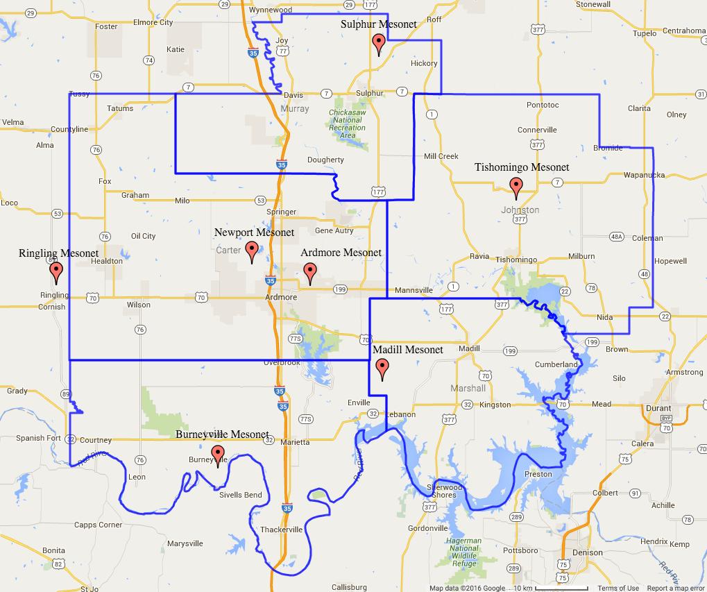
2 Additional Map: 2

3 Part 1: Interpreting Heavy Rainfall Forecast Products and Ingredients Before an Event Question 1. What role is your group playing for this exercise? Include your area of responsibility. On Sunday, June 14, 2015 you hear on the news about Oklahoma receiving the remnants of a tropical storm Wednesday to Thursday of the upcoming work week. You pull up the following 5-day rainfall forecast map from the NWS Weather Prediction Center to prepare for your week. Question 2. Where is the heaviest precipitation forecast to be in Oklahoma? Approximately how much rain is your area of responsibility expected to get in the next week? Question 3. What (if any) actions would you be taking at this point? 3
 for your area of responsibility now? Question 5.")
4 It is now Tuesday, June 16, 2015 the day before the remnants of the storm are expected to enter Oklahoma. You see this 3-day rainfall map from the NWS Weather Prediction Center. Question 4. Describe how the forecast has changed since the one you saw on Sunday. What is the predicted rainfall (approximate) for your area of responsibility now? Question 5. The tropical system is forecast to enter Oklahoma tomorrow. What actions would you be taking at this juncture? 4
 and winds (in miles per hour) at 7PM on Tuesday, June 16, 2015. Question 7.")
5 Question 6. What are the four weather ingredients needed for heavy rainfall events? It is the evening before the remnants of the storm are expected to move into Oklahoma. The below map shows a regional look at dew point temperatures (in degrees Fahrenheit) and winds (in miles per hour) at 7PM on Tuesday, June 16, Question 7. What critical dew point value (and above) is needed for heavy rainfall? On the above regional map draw a line separating areas that are meeting this requirement from areas that are below it. What parts of Oklahoma are at or above this critical dew point value? Question 8. The tropical storm is currently down in Texas. Based on the wind information, mark where the center of the circulation is on the above regional map with an L. 5
 are important because they give a rough estimate of storm motion and speed. Question 9.")
6 It is still the evening before the storm remnants are expected to impact Oklahoma. The following 500 millibar map shows winds (in knots) and other conditions at 7PM on Tuesday, June 16, Winds at this level (approximately 18,000 feet up) are important because they give a rough estimate of storm motion and speed. Question 9. Wind speeds of knots or less at 500 millibars lead to very slow moving storms that could produce flooding conditions. Please indicate that speed below. Where are these conditions being met in the south central U.S.? Question 10. If storms were occurring in southern Oklahoma at this point, what would their approximate speed be? 6
.")
7 Part 2: Monitoring Key Heavy Rainfall Products During an Event For this second part of the lab we will transition our focus to monitoring radar as well as Mesonet data. Open up the RadarFirst software. At the top of RadarFirst, go to Edit à Date... Change the date to 6/17/2015 and change the time to 12PM. View the data in 1-pane mode (View à One Pane). Make sure cities are visible on the map (Edit à Options à Show Cities). Question 11. Play a 3-hour animation (9AM-12PM) of BREF1 from the KTLX (Oklahoma City) radar. What direction is the entire tropical system moving? What direction are individual storms moving? Question 12. Go to Edit à Date and change your time to 6PM. View a 3-hour animation (3-6PM) of BREF1 from KTLX. Describe what you are seeing on radar in southern Oklahoma. We would say that the radar echoes are. (Fill in the blank) At 6PM you also view the following 3-hour Mesonet rainfall map. Question 13. Given the radar trends you have observed and the above 3-hour Mesonet rainfall map, what actions would you be taking in your jurisdiction at this time? 7
8 Go to Edit à Date and change your time to 9PM. Switch to 2 panel mode (View à Two Panes). In the left window load RAINS (storm total rainfall) and in the right window load BREF1. View a 3-hour animation from KTLX. Question 14. What time period is the RAINS (storm total rainfall) product showing right now? How many hours is that? In your left window move your mouse cursor over the colors. What are highest rain totals you can find? Question 15. Focusing only on the 5 southern Oklahoma counties identified on page 1 compare the radarestimated rainfall totals you were just seeing to the below Mesonet rainfall map for the same time period. How much different are they? Which one has the higher values? Question 16. On Mesonet rainfall maps what do the colors represent? What is the source of that information? What do the numbers represent? 8
Lab: Using Correlation Coefficient During Winter Events
 Lab: Using Correlation Coefficient During Winter Events Objective: In this lab exercise we will investigate a couple winter weather events from late 2013 to see how the correlation coefficient radar product
Dual-Pol RadarFirst Lab Exercise
 Dual-Pol RadarFirst Lab Exercise Possible Uses of Dual-Pol Radar Data for Emergency Management Objective: This exercise serves as a first introduction to using dual-pol radar data. In the lab, you will
TROPICAL STORM HARVEY BRIEFING
 TROPICAL STORM HARVEY BRIEFING 10:00 AM CDT Sunday, August 27, 2017 Prepared by: NWS LIX NWSNewOrleans www.weather.gov/neworleans Situation Overview New Information Tropical Storm Winds 40mph Immediate
Prolonged Coastal Storm October 9 th -12 th, 2013
 Prolonged Coastal Storm October 9 th -12 th, 2013 Prepared 400 PM EDT Tuesday, October 8th, 2013 Gary Szatkowski NOAA s NJ Forecast office http://www.erh.noaa.gov/phi/ Purpose of Briefing Briefing #1 for
TROPICAL STORM HARVEY COE Navigation Call - Update
 TROPICAL STORM HARVEY COE Navigation Call - Update 10:00 AM CDT Tuesday, August 29, 2017 Prepared by: NWS LIX NWSNewOrleans www.weather.gov/neworleans Situation Overview New Information Drifting ENE at
Active Weather Threat Halloween Week Nor easter October 28 th 31 st 2012
 Active Weather Threat Halloween Week Nor easter October 28 th 31 st 2012 Prepared 1130 AM EDT Wednesday, October 24, 2012 Gary Szatkowski NOAA s NJ Forecast Office Weather.gov/phi Purpose of Briefing Briefing
Department of Earth & Climate Sciences San Francisco State University Fall 2018 ERTH 360. Homework #1 Answer Sheet (Graphics Online) 100 points
 100 points") Department of Earth & Climate Sciences Name San Francisco State University Fall 2018 ERTH 360 Homework #1 Answer Sheet (Graphics Online) 100 points (Due Beginning of Class, Thursday 20 September 2018)
Department of Earth & Climate Sciences Name San Francisco State University Fall 2018 ERTH 360 Homework #1 Answer Sheet (Graphics Online) 100 points (Due Beginning of Class, Thursday 20 September 2018)
ERTH 365 Homework #2: Hurricane Harvey. 100 points
 ERTH 365 Homework #2: Hurricane Harvey 100 points Due by 6pm, Tuesday 30 October 2018, ELECTRONIC SUBMISSON BY EMAIL ONLY BY 6PM (send to klevey@sfsu.edu) (acceptable formats: MS Word, Google Doc, plain
Significant Flooding Expected
 Significant Flooding Expected Decision Support Briefing #5 As of: 9:00 AM September 14, 2018 What Has Changed? Flash Flood Watch now in effect for part of area, will be expanded later today 9/14/2018 9:23
Department of Earth & Climate Sciences San Francisco State University Fall 2016 ERTH 360. Homework #1 Answer Sheet (Graphics Online) 100 points
 100 points") Department of Earth & Climate Sciences Name San Francisco State University Fall 2016 ERTH 360 Homework #1 Answer Sheet (Graphics Online) 100 points (Due Beginning of Class, Thursday 22 September 2016)
Department of Earth & Climate Sciences Name San Francisco State University Fall 2016 ERTH 360 Homework #1 Answer Sheet (Graphics Online) 100 points (Due Beginning of Class, Thursday 22 September 2016)
TROPICAL STORM HARVEY BRIEFING
 TROPICAL STORM HARVEY BRIEFING 2:00 PM CDT Tuesday, August 29, 2017 Prepared by: NWS LIX NWSNewOrleans www.weather.gov/neworleans Situation Overview New Information Moving NNE Max sustained wind 45 mph
IWT Scenario 2 Integrated Warning Team Workshop National Weather Service Albany, NY October 31, 2014
 IWT Scenario 2 Integrated Warning Team Workshop National Weather Service Albany, NY October 31, 2014 09 10 11 12 13 Scenario 2 Timeline December 9-13 Tue Wed Thu Fri Sat Tue, Dec. 9 @ 5 am 2014 2014 2014
IWT Scenario 1 Integrated Warning Team Workshop National Weather Service Albany, NY October 31, 2014
 Integrated Warning Team Workshop National Weather Service Albany, NY October 31, 2014 23 24 25 26 27 Scenario 1 Timeline November 23-27 Sun Mon Tue Wed Thu Thanksgiving Day Sunday, Nov. 23 @ 430 pm NWS
Monday, October 19, CDT Brian Hoeth
 Monday, October 19, 2015 1400 CDT Brian Hoeth Some of the briefing presented is worstcase scenario and may differ in detail from local NWS Weather Forecast Offices. National Weather Service Southern Region
WEDNESDAY 30 TH AUGUST, :57 p.m. Tropical Storm Irma forms in the Atlantic. Don t let your guard down, always #Be Ready.
 Chapter 1 - The Set Up In the days leading up to Irma a series of composed and sobering text messages, presented in truncated form below, from Department of Disaster Management warned us of the pending
September 13, 2018 MEDIA RELEASE. Waynesboro Department of Emergency Management Waynesboro Police Department Waynesboro Fire Department
 MEDIA RELEASE September 13, 2018 The City continues to prepare for and monitor the track and potential impacts of Hurricane Florence. Current guidance from the National Weather Service, the National Hurricane
Severe Weather Potential for Southeast Texas
 Severe Weather Potential for Southeast Texas Dan Reilly, Kent Prochazka, Scott Overpeck National Weather Service Houston/Galveston 10 am Synopsis Storm to likely bring severe weather to Southeast Texas
Issued by: National Weather Service San Joaquin Valley - Hanford CA. Issue time: 409 AM PST Wed Jan
 Forecast Information Location: New_Exchequer_Dam Updated: January 16, 2019, 11:45 am NWS Weather Discussion: Issued by: National Weather Service San Joaquin Valley - Hanford CA Issue time: 409 AM PST Wed
May 31, Flood Response Overview
 May 31, 2013 Flood Response Overview Suppression 867 Personnel on three (3) shifts 289 Red Shift (A) 289 Blue Shift (B) 289 Green Shift (C) Department Overview Department Overview EMS: 40,934 False Alarm:
Indiana County Flash Flood of 22 June 2017
 Indiana County Flash Flood of 22 June 2017 By Richard H. Grumm National Weather Service State College, PA 1. Overview Slow moving thunderstorms brought 3 to 4 inches of rainfall to Indiana County, PA during
Major Hurricane Matthew Briefing Situation Overview
 Major Hurricane Matthew Briefing Situation Overview At 5 p.m. Tuesday, Category 4 Hurricane Matthew was about 860 miles South-Southeast of Mayport, Florida, moving north around 10 mph. Maximum sustained
Winter Weather. National Weather Service Buffalo, NY
 Winter Weather National Weather Service Buffalo, NY Average Seasonal Snowfall SNOWFALL = BIG IMPACTS School / government / business closures Airport shutdowns/delays Traffic accidents with injuries/fatalities
Hurricane Harvey and What is to come. Eric Berger, Space City Weather
 Hurricane Harvey and What is to come Eric Berger, Space City Weather Today s talk A word about Space City Weather Social media-rology A look back at Hurricane Harvey Why does Houston get these storms Rainfall
TXWARN Tabletop Exercise: Hurricane Helen
 TXWARN Tabletop Exercise: Hurricane Helen July 31, 2015 Administrative Details In-studio participants and remote participants Situation manual Evaluations Training hours 1 In Studio: Welcome and Introductions
Tropical Weather Briefing
 Tropical Weather Briefing August 28, 2012 700 AM CDT National Weather Service Weather Forecast Office Slidell, LA Current Satellite Tropical Storm Isaac Watches/Warnings Tropical Storm Isaac Track Guidance
Student Exploration: Hurricane Motion
 Name: Date: Student Exploration: Hurricane Motion Vocabulary: air pressure, Coriolis effect, eye, hurricane, knot, meteorologist, precipitation Prior Knowledge Questions (Do these BEFORE using the Gizmo.)
Lab 19.2 Synoptic Weather Maps
 Lab 19.2 Synoptic Weather Maps Name: Partner: Purpose The purpose of this lab is to have you read and interpret the information displayed on synoptic weather maps. You will also learn the techniques used
DEPARTMENT OF EARTH & CLIMATE SCIENCES SAN FRANCISCO STATE UNIVERSITY. Metr Fall 2014 Test #1 September 30, 2014
 DEPARTMENT OF EARTH & CLIMATE SCIENCES SAN FRANCISCO STATE UNIVERSITY NAME Metr 302.02 Fall 2014 Test #1 September 30, 2014 200 pts (4 pts each answer) Part I. Surface Chart Interpretation. Questions 1
Tropical Update. 5 PM EDT Tuesday, September 5, 2017 Hurricane Irma, Tropical Storm Jose, and Tropical Depression Thirteen
 Tropical Update 5 PM EDT Tuesday, September 5, 2017 Hurricane Irma, Tropical Storm Jose, and Tropical Depression Thirteen This update is intended for government and emergency response officials, and is
Identifying Biomes from Climatograms
 Identifying Biomes from Welcome to your climatogram lab. In this lab you will investigate the between the amount of rainfall and the variance of temperature and the effect on the distribution of biomes
Tropical Update. 11 AM EDT Wednesday, October 10, 2018 Hurricane Michael, Hurricane Leslie & Tropical Storm Nadine, Caribbean Low (40%)
") Tropical Update 11 AM EDT Wednesday, October 10, 2018 Hurricane Michael, Hurricane Leslie & Tropical Storm Nadine, Caribbean Low (40%) This update is intended for government and emergency response officials,
Tropical Update 11 AM EDT Wednesday, October 10, 2018 Hurricane Michael, Hurricane Leslie & Tropical Storm Nadine, Caribbean Low (40%) This update is intended for government and emergency response officials,
Nor easter Monday Night Wednesday December 8 10, 2014
 Nor easter Monday Night Wednesday December 8 10, 2014 Prepared 400 PM EST Monday, December 8, 2014 Mitchell Gaines NOAA s Philadelphia/Mount Holly NJ Forecast Office www.weather.gov/phi/ Purpose of Briefing
Charles Kuster Leadville, CO. Personal Overview
 Charles Kuster Leadville, CO Personal Overview Personal Overview Charles Kuster Leadville, CO OU to study meteorology Charles Kuster Leadville, CO Personal Overview OU to study meteorology Graduated in
A Prepared Marylander Creates a Resilient Maryland
 Maryland Emergency Management Agency Operations Directorate Hazardous Winter Weather Outlook Briefing March 5, 2013 0800 A Prepared Marylander Creates a Resilient Maryland A strong low pressure will track
Hurricane Harvey: SE Texas Impacts. 10 AM CDT UPDATE Saturday, August 26, 2017 Prepared by: Dan Reilly, Brian Kyle
 Hurricane Harvey: SE Texas Impacts 10 AM CDT UPDATE Saturday, August 26, 2017 Prepared by: Dan Reilly, Brian Kyle Latest Observations and Radar Hurricane Harvey centered near Victoria and weakening Wind
HURRICANE HARVEY COE Navigation BRIEFING
 HURRICANE HARVEY COE Navigation BRIEFING 10:00 AM CDT Friday, August 25, 2017 NWSNewOrleans www.weather.gov/neworleans Situation Overview New Information Harvey continues to strengthen Max sustained winds
Tropical Update. 5 AM EDT Tuesday, September 12, 2017 Post-Tropical Cyclone Irma, Hurricane Jose, & Tropical Wave (10%)
") Tropical Update 5 AM EDT Tuesday, September 12, 2017 Post-Tropical Cyclone Irma, Hurricane Jose, & Tropical Wave (10%) This update is intended for government and emergency response officials, and is provided
Tropical Update 5 AM EDT Tuesday, September 12, 2017 Post-Tropical Cyclone Irma, Hurricane Jose, & Tropical Wave (10%) This update is intended for government and emergency response officials, and is provided
A HURRICANE IS COMING. Presented by Atiba Upchurch Broward Emergency Management Division
 A HURRICANE IS COMING Presented by Atiba Upchurch Broward Emergency Management Division Mission Statement To safeguard the lives and property of the people of Broward County from major hazards and emergencies
TROPICAL DEPRESSION HARVEY BRIEFING
 TROPICAL DEPRESSION HARVEY BRIEFING 10:15 PM CDT Wednesday, August 23, 2017 Prepared by: Lara Beal NWSCorpus www.weather.gov/corpuschristi Situation Overview No changes to Watches. Hurricane Watch remains
We Had No Warning An Overview of Available Forecast Products Before and During Severe Weather Events
 We Had No Warning An Overview of Available Forecast Products Before and During Severe Weather Events Two main sources for severe weather info NOAA/NWS Storm Prediction Center (SPC) Convective Outlooks
TROPICAL STORM HARVEY BRIEFING
 TROPICAL STORM HARVEY BRIEFING 8:00 AM CDT Monday, August 28, 2017 Prepared by: Brian Hoeth, Jason Johnson, on behalf of WGRFC www.weather.gov Current Storm Total Rainfall and River Flood Status 24 Storm
SITUATION REPORT #7 September 8 th, 2017
 MCO AIRPORT EMERGENCY OPERATIONS CENTER SITUATION REPORT #7 September 8 th, 2017 STATE OF FLORIDA REGION V FEMA REGION IV GENERAL INFORMATION Local State of Emergency Declaration Number: 17-235 Dated:
Tropical Update. 11 AM EDT Tuesday, October 9, 2018 Hurricane Michael, Tropical Storm Leslie, Tropical Storm Nadine
 Tropical Update 11 AM EDT Tuesday, October 9, 2018 Hurricane Michael, Tropical Storm Leslie, Tropical Storm Nadine This update is intended for government and emergency response officials, and is provided
Flood Scenario Worksheet
 Flood Scenario Worksheet Scenario adapted from: http://www.epa.gov/watersecurity/tools/trainingcd/simple/source/scenario-8/ssc8-0.pdf Simple Tabletop Exercise, Interdependency Natural Disaster Scenario,
NOAA s National Weather Service Philadelphia/Mt. Holly NJ
 Next Briefing Package: Thursday, October 1, 2015 no later than 300 PM Hazards and Impacts: Overview: A dangerous weather pattern is developing for our region. Threats include very heavy rainfall, inland
Advanced Spotter Training Welcome! Lesson 1: Introduction and Why Spotters are Important
 Advanced Spotter Training 2009 Welcome! Lesson 1: Introduction and Why Spotters are Important Introduction This course is intended to advance the basic training given by the National Weather Service (NWS).
California OES Weather Threat Briefing
 California OES Weather Threat Briefing Wednesday, January 16, 2019 9:00 AM PST Day 1: Strong winds, heavy mountain snow and heavy rain with isolated thunderstorms across much of the state through Thursday
Weather briefing Strong Coastal Nor easter November 7 th -8 th, 2012
 Weather briefing Strong Coastal Nor easter November 7 th -8 th, 2012 Prepared 1215 PM EDT Wednesday November 7, 2012 Gary Szatkowski NOAA s NJ Forecast Office http://www.erh.noaa.gov/phi/ Purpose of Briefing
Trends Forecasting. Overview: Objectives: GLEs Addressed: Materials: Activity Procedure:
 Trends Forecasting Overview: How do meteorologists forecast weather? Students learn one of 5 main methods for forecasting weather, use it to create a forecast, and analyze results. Objectives: The student
Radar Meteorology AOS 444 October 28, 2002 Laboratory 6: WATADS study of Oakfield tornado from KGRB
 Radar Meteorology AOS 444 October 28, 2002 Laboratory 6: WATADS study of Oakfield tornado from KGRB YOUR NAME: YOUR PARTNER S NAME: On July 18, 1996 the town of Oakfield, Wisconsin was all but destroyed
photo courtesy of
 BRITISH VIRGIN ISLANDS REPORT TROPICAL STORM JEANNE photo courtesy of www.bviplatinum.com PREPARED BY THE DEPARTMENT OF DISASTER MANAGEMENT 1 EVENT 13 th -16 th September, 2004 TROPICAL STORM JEANNE Sequence
NWS Resources For School Districts
 NWS Resources For School Districts January 23rd, 2017 Shawn DeVinny shawn.devinny@noaa.gov Meteorologist National Weather Service Twin Cities/Chanhassen, MN Outline Watches/Warnings/Advisories Example
Weather briefing Strong Coastal Nor easter November 7 th -8 th, 2012
 Weather briefing Strong Coastal Nor easter November 7 th -8 th, 2012 Prepared 1245 PM EDT Tuesday November 6, 2012 Gary Szatkowski NOAA s NJ Forecast Office Weather.gov/phi Purpose of Briefing Briefing
WEATHER SYSTEMS IMPACTING THE CAYMAN ISLANDS Prepared by the staff of the Cayman Islands National Weather Service
 WEATHER SYSTEMS IMPACTING THE CAYMAN ISLANDS 2008 Prepared by the staff of the Cayman Islands National Weather Service TROPICAL STORM DOLLY Formed 194 miles west of Grand Cayman July 19 th. The tropical
ATS 351, Spring 2010 Lab #9 Weather Radar - 55 points
 ATS 351, Spring 2010 Lab #9 Weather Radar - 55 points 1. (5 points) If a radar has a maximum unambiguous range of 300km, what is its PRF? (The speed of light, c, is equal to 3x10 8 m/s) 2. (5 points) Explain
Marshall Alexander Forecaster Commonwealth of Dominica
 Marshall Alexander Forecaster Commonwealth of Dominica Dominica 2015 Impacts Tropical Storm Danny (August 24 th ) Tropical Storm Erika (August 27 th ) Tropical Storm Grace (Remnants) (September 10 th -11
GC Briefing. Weather Sentinel Hurricane Florence. Status at 5 PM EDT (21 UTC) Today (NHC) Discussion. September 13, 2018
 Today (NHC) Discussion. September 13, 2018") GC Briefing September 13, 2018 Weather Sentinel Hurricane Florence Tropical storm conditions have been reported for areas of North Carolina and will continue to spread inland to the west and south. Hurricane
GC Briefing September 13, 2018 Weather Sentinel Hurricane Florence Tropical storm conditions have been reported for areas of North Carolina and will continue to spread inland to the west and south. Hurricane
ESCI 1010 Lab 6 Midlatitude Cyclones and Thunderstorms
 ESCI 1010 Lab 6 Midlatitude Cyclones and Thunderstorms Before Lab: Review pages 244-324 in your Weather and Climate textbook. Pay special attention to the sections entitled Fronts, Life Cyclone of a Midlatitude
Tropical Update. 5 PM EDT Sunday, October 7, 2018 Tropical Storm Michael, Tropical Storm Leslie, & Invest 92L (30%)
") Tropical Update 5 PM EDT Sunday, October 7, 2018 Tropical Storm Michael, Tropical Storm Leslie, & Invest 92L (30%) This update is intended for government and emergency response officials, and is provided
Tropical Update 5 PM EDT Sunday, October 7, 2018 Tropical Storm Michael, Tropical Storm Leslie, & Invest 92L (30%) This update is intended for government and emergency response officials, and is provided
Tropical Update. 5 PM EDT Thursday, August 27, 2015 Tropical Storm Erika
 Tropical Update 5 PM EDT Thursday, August 27, 2015 Tropical Storm Erika This update is intended for government and emergency response officials, and is provided for informational and situational awareness
Hydrologic Briefing Tropical Storm Harvey
 Hydrologic Briefing Tropical Storm Harvey 10:30 AM CDT Sunday, August 27, 2017 Prepared by: John Metz NWSCorpus www.weather.gov/corpuschristi Situation Overview Tropical Storm Harvey Harvey to remain a
PREDICTING THE WEATHER
 NAME DATE PARTNER(S) PREDICTING THE WEATHER How well does your local weatherman do in predicting the weather? Is he or she more accurate for the next day or for a week in the future? Why do you think that
Science and Literacy. Lesson Sets. Weather vs. Climate. By Elementary Ali. Created by Elementary Ali 2014
 d Science and Literacy Lesson Sets Weather vs. Climate By Elementary Ali These activities are created to incorporate reading and writing into the Science curriculum. Each lesson is designed to last about
Fundamentals of Transmission Operations
 Fundamentals of Transmission Operations Load Forecasting and Weather PJM State & Member Training Dept. PJM 2014 9/10/2013 Objectives The student will be able to: Identify the relationship between load
Hydrologic Briefing Tropical Storm Harvey
 Hydrologic Briefing Tropical Storm Harvey 5:00 PM CDT Sunday, August 27, 2017 Prepared by: Jennifer Dunn/Christina Barron NWSCorpus www.weather.gov/corpuschristi Situation Overview Tropical Storm Harvey
Name(s): Date: yourself (representing the Earth, with your nose representing the location of Las Cruces) Work in Groups of Three People!
: Date: yourself (representing the Earth, with your nose representing the location of Las Cruces) Work in Groups of Three People!") Name(s): Date: 3 Phases of the Moon 3.1 Introduction You will need the following materials for this lab: small spheres (representing the Moon), with two different colored hemispheres. The dark hemisphere
Name(s): Date: 3 Phases of the Moon 3.1 Introduction You will need the following materials for this lab: small spheres (representing the Moon), with two different colored hemispheres. The dark hemisphere
NWS HURRICANES June 3, 2015
 NWS HURRICANES June 3, 2015 Hurricane Season June 1 November 30 2 What s the concern? All tropical systems passing within 125nm of central Maryland since 1950 Mid-Atlantic Hurricanes Greatest Risk: August
Massachusetts Department of Public Health Emergency Preparedness Bureau. August 27, hrs
 Massachusetts Department of Public Health Emergency Preparedness Bureau August 27, 2011 1500 hrs Health and Medical Situational Awareness Report: Hurricane Irene Situational Awareness Report: Hurricane
Forecast Models. General Meteorology Laboratory #11
 General Meteorology Laboratory #11 Name Partners Forecast Models Date _ Section Purpose: Develop the ability to contour two dimensional data and use the resulting information to locate a cold front. Equipment:
GC Briefing. Weather Sentinel Tropical Storm Michael. Status at 8 AM EDT (12 UTC) Today (NHC) Discussion. October 11, 2018
 Today (NHC) Discussion. October 11, 2018") GC Briefing Weather Sentinel Tropical Storm Michael October 11, 2018 After making landfall as a high-end category-4 hurricane on the Florida Panhandle, Michael weakened to tropical storm status early this
GC Briefing Weather Sentinel Tropical Storm Michael October 11, 2018 After making landfall as a high-end category-4 hurricane on the Florida Panhandle, Michael weakened to tropical storm status early this
California OES Atmospheric River Events Weather Threat Briefing
 California OES Atmospheric River Events Weather Threat Briefing 23 February 2017 10:00 AM PST Day 1: Flooding continues along small streams and creeks and some main stem rivers. National Weather Service
Complete Weather Intelligence for Public Safety from DTN
 Complete Weather Intelligence for Public Safety from DTN September 2017 White Paper www.dtn.com / 1.800.610.0777 From flooding to tornados to severe winter storms, the threats to public safety from weather-related
Tropical Update. 5 PM EDT Sunday, September 10, 2017 Hurricane Irma, Hurricane Jose, Tropical Wave (60%)
") Tropical Update 5 PM EDT Sunday, September 10, 2017 Hurricane Irma, Hurricane Jose, Tropical Wave (60%) This update is intended for government and emergency response officials, and is provided for informational
Tropical Update 5 PM EDT Sunday, September 10, 2017 Hurricane Irma, Hurricane Jose, Tropical Wave (60%) This update is intended for government and emergency response officials, and is provided for informational
Arizona Climate Summary October 2015 Summary of conditions for September 2015
 September 2015 Temperature and Precipitation Summary Arizona Climate Summary October 2015 Summary of conditions for September 2015 September 1 st 18 th : September began with high pressure over southern
Unit 4. This unit will enable you to improve coordination and communication with State and local agencies when hazardous weather threatens.
 Unit 4 This unit will enable you to improve coordination and communication with State and local agencies when hazardous weather threatens. In this unit we will discuss the role of Emergency Managers in
Daily Operations Briefing. Wednesday, August 23, :30 a.m. EDT
 Daily Operations Briefing Wednesday, August 23, 2017 8:30 a.m. EDT Significant Activity August 22-23 Significant Events: Tropical Weather Threat Gulf Coast Tropical Activity: Atlantic Disturbance 1 High
The Long-lived eastern US tornadic supercell of 20 July 2017
 1. Overview The Long-lived eastern US tornadic supercell of 20 July 2017 By Richard H. Grumm and Elissa A Smith National Weather Service State College, PA A long lived supercell developed near the eastern
Construction and Interpretation of Weather Station Models
 Fall Semester Regents Earth Science John Dewey High School Mr. Klimetz Construction and Interpretation of Weather Station Models An Exercise in the Construction and Interpretation of Weather Station Models
Enhancing Weather Information with Probability Forecasts. An Information Statement of the American Meteorological Society
 Enhancing Weather Information with Probability Forecasts An Information Statement of the American Meteorological Society (Adopted by AMS Council on 12 May 2008) Bull. Amer. Meteor. Soc., 89 Summary This
Tropical Storm Colin Briefing Last Briefing on this System
 Tropical Storm Colin Briefing Last Briefing on this System NWS WFO Jacksonville, Florida Tuesday, June 07, 2016 6:00 a.m. EDT Tropical Storm Colin s Impacts SE Georgia & North Florida Local Watches & Warnings:
5E's. View the video clip:
 5E's TEKS 8.10 (C) identify the role of the oceans in the formation of weather systems such as hurricanes Engage View the video clip: http://www.youtube.com/watch?v=h9vpwmtnozc What is a hurricane? How
Major Hurricane Earl
 Major Hurricane Earl Advisory 32 North Carolina Threat Assessment Prepared at: 8 AM Thursday September 2, 2010 Hurricane and Tropical Storm Warnings in effect for the North Carolina Coast and Sounds. NWS
Texas Statewide Mesonet Network (TexMesonet) Dr. Kantave Greene 11/15/17
 Dr. Kantave Greene 11/15/17") Texas Statewide Mesonet Network (TexMesonet) Dr. Kantave Greene 11/15/17 1 Observe weather features Why Mesonets? Thunderstorms Squall lines Dry-lines Sea breezes Improve weather & flood forecasts Drought
Texas Statewide Mesonet Network (TexMesonet) Dr. Kantave Greene 11/15/17 1 Observe weather features Why Mesonets? Thunderstorms Squall lines Dry-lines Sea breezes Improve weather & flood forecasts Drought
TROPICAL STORM HARVEY BRIEFING
 TROPICAL STORM HARVEY BRIEFING 1 PM CDT Saturday, August 26, 2017 Prepared by: John Metz NWSCorpus www.weather.gov/corpuschristi Overview Life-threatening conditions continue. Storm Surge Warnings remain
1. Open IDV. There is a desktop link, choose version 3.0u1 or 3.0u2. It can take a few minutes to open.
 Page 1 Objectives: Become familiar with using a software package (IDV) to view satellite images Understand the differences between Visible, IR, and Microwave Imagery Observe the influence of dry air and
Situation Manual Protective Actions
 Situation Manual Protective Actions 175 Minutes Situation Manual Tabletop Exercise 1 Disaster Resistant Communities Group www.drc-group.com Tallahassee Twister Start Exercise No Image During the exercise
A) B) C) D) 2) The diagrams below show the phases of the Moon as viewed by an observer in New York State at different times in August.
 B) C) D) 2) The diagrams below show the phases of the Moon as viewed by an observer in New York State at different times in August.") Name: 1) Which weather station model indicates the highest relative humidity? 8605-1 - Page 1 A) B) C) D) 2) The diagrams below show the phases of the Moon as viewed by an observer in New York State at
Name: 1) Which weather station model indicates the highest relative humidity? 8605-1 - Page 1 A) B) C) D) 2) The diagrams below show the phases of the Moon as viewed by an observer in New York State at
WEATHER MAP INFORMATION STATION MODEL. Station Model Lab. Period Date
 Name Station Model Lab Period Date At commer cial air por t s t hr oughout t he count r y t he weat her is obser ved, measur ed and r ecor ded. I n New Yor k St at e alone t her e ar e over a dozen obser
General Meteorology Laboratory #11. Forecast Models
 General Meteorology Laboratory #11 Name Partners Forecast Models Date _ Section Purpose: Develop the ability to contour two dimensional data and use the resulting information to locate a cold front. Equipment:
NWS SERFC Hydrologic Vulnerability Assessment. Monday, March 9 th, 2015 NOAA, National Weather Service Southeast River Forecast Center
 NWS SERFC Hydrologic Vulnerability Assessment Monday, March 9 th, 2015 NOAA, National Weather Service Southeast River Forecast Center Current Weather Map Today s weather map shows a blossoming system in
HEADLINES ** 2 ND FROST POSSIBLE FOR THE SHEANANDOAH VALLEY THURSDAY MORNING 4/17??***
 HEADLINES DATA SHOWS CLOUDS WINDS VERY LOW DEW POINTS OVER NIGHT WHICH MAY SAVE THE DAY AND PREVENT MAJOR FROST FREEZE IN SOME AREAS WEDNESDAY MORNING ** 2 ND FROST POSSIBLE FOR THE SHEANANDOAH VALLEY
Hurricane Matthew Threats and Impacts Briefing for Eastern NC
 Hurricane Matthew Threats and Impacts Briefing for Eastern NC October 6 th, 2016 Date/Time Created: 10/6/2016, Noon EDT National Weather Service Newport/Morehead City, NC Hurricane Matthew Key Points Changes
NOAA s National Weather Service Philadelphia/Mt. Holly NJ
 Next Briefing Package: Friday, October 2, 2015 no later than 300 PM Hazards and Impacts: Overview: A dangerous weather pattern still threatens our region. Threats include very heavy rainfall, inland river
Miami-Dade County Overview
 Miami-Dade County Overview 2,000 square miles World s busiest cruise port 2.6 million residents Second busiest US airport for international travelers Gateway to the Caribbean and Latin America Natural
Department of Geosciences San Francisco State University Spring Metr 201 Monteverdi Quiz #5 Key (100 points)
") Department of Geosciences Name San Francisco State University Spring 2012 Metr 201 Monteverdi Quiz #5 Key (100 points) 1. Fill in the Blank or short definition. (3 points each for a total of 15 points)
Department of Geosciences Name San Francisco State University Spring 2012 Metr 201 Monteverdi Quiz #5 Key (100 points) 1. Fill in the Blank or short definition. (3 points each for a total of 15 points)
Active Winter Weather Pattern February 4th-9th
 Active Winter Weather Pattern February 4th-9th Prepared 1230 PM EST Tuesday, February 4, 2014 Gary Szatkowski NOAA s NJ Forecast office http://www.erh.noaa.gov/phi/ Purpose of Briefing Briefing #6 Promote
Tropical Storm Harvey: SE Texas Impacts
 Tropical Storm Harvey: SE Texas Impacts 10 AM CDT UPDATE Thursday, August 24, 2017 Prepared by: Dan Reilly, Brian Kyle PLEASE MUTE YOUR LINES AND DON T PUT ON HOLD! Situation Overview Tropical Storm Harvey
Daily Operations Briefing Tuesday, May 31, :30 a.m. EDT
 Daily Operations Briefing Tuesday, May 31, 2016 8:30 a.m. EDT Severe Weather and Flooding - Texas Current Situation: Beginning May 26 and continuing, heavy rain continues over Southern Plains 10 inches
Pressure Conversion in Millibars
 Name Date The Weather Map Biggie Lab: Make it Colorful and Purty! Now that you have learned about all of the different variables that contribute to daily changes in weather, it is now time to bring it
National Weather Service Flood Forecast Needs: Improved Rainfall Estimates
 National Weather Service Flood Forecast Needs: Improved Rainfall Estimates Weather Forecast Offices Cleveland and Northern Indiana Ohio River Forecast Center Presenter: Sarah Jamison, Service Hydrologist