UK Contribution to YMC Observational Field Campaign
|
|
|
- James Fox
- 5 years ago
- Views:
Transcription


1 UK Contribution to YMC Observational Field Campaign Land, air and sea, operational modelling YMC 3 rd Workshop, Malaysia 2017 Paul Barrett paul.barrett@metoffice.gov.uk
2 UK Involvement in YMC HotHouse TerraMaris FAAM Aircraft, Sea Gliders, Ground Stations, Modelling New Proposal New Name New Timeline Same Objectives Submission very soon Funding Decision: Spring 2018 Field Campaign, IOP, Indonesia Nov 2019 to February 2020 Depends on obtaining permissions early
3 UK Involvement in YMC FAAM Aircraft, Sea Gliders, Ground Stations FAAM BAe146 Aircraft Base: (Jakarta - Halim?) 5 weeks, 25 flights, 5 hours each 2020 Jan / Feb inter-monsoon Ground Based Super Site(s) IOP at same time as Aircraft Campaign Christmas Island (Aus) South West Java (LAPAN site) Seagliders 3 Months, Java - Xmas Island Section Ocean Mixed Layer, Diurnal Warm Layer Atmos Ocean heat and momentum flux

4 Real-time convective-scale forecast models Series of regional models nested directly inside the operational UM global model Forecasts run twice a day: T+120 for full 4.4 km domain T+36 for 1.5 km domains Available for use in supporting other field campaigns Long-term, not just YMC period Improve... global models... large scale atmospheric processes... high impact weather... SE Asia Representation of regional process... convective scale... severe weather Science to operational... develop advice... mitigate against high impact weather.
5 Real-time convective-scale forecast models Series of regional models nested directly inside the operational UM global model Forecasts run twice a day: T+120 for full 4.4 km domain T+36 for 1.5 km domains Available for use in supporting other field campaigns Long-term, not just YMC period Future Upgrade the outer domain to 1.5km Forecasts available on password-protected website: Some agencies already have access
6 UK Proposed Airborne and Ground Field Work Java to Christmas Island transect Research Stations on Java and Christmas Island FAAM Aircraft based near Jakarta Halim range 600nm Seagliders work between Java and Christmas Island FAAM Could also base at: Semerang, Yogyakarta, Bandar Lampung FAAM Sea Gliders (NASA Blue Marble, Topo./Bathy - January)


7 Field campaign overview Australian territory
 5 Hours 100 m/s (210 kns IAS) 15 m/s max updraught No Hail No Lightening Crew 2 Pilots, 18 Scientists /")
8 FAAM BAe Operating Characteristics Altitude Envelope Range Endurance Science Speed Limitations 50 ft to 33 kft (in Tropics) 3700 km (2000 nm) 5 Hours 100 m/s (210 kns IAS) 15 m/s max updraught No Hail No Lightening Crew 2 Pilots, 18 Scientists / Observers


9 Instrument Payload Temperature Humidity Liquid water Ice Water Aerosol Inlets Cloud microphysics Radiometers / Interferometers IR: ARIES, sub-mm: ISMAR, Microwave: MARSS


10 BAe146 Flying Across wind surface flux measurements (100ft a.s.l.) ~10 science crew In-situ measurements
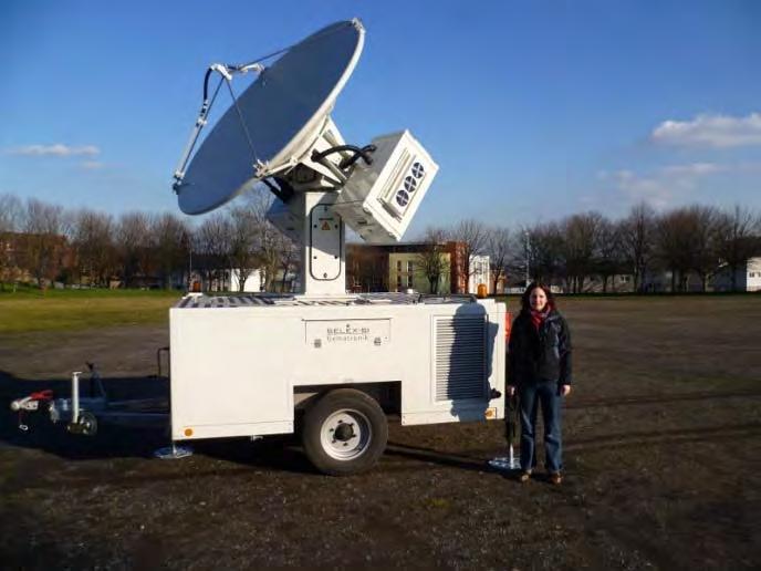


11 Ground instrumentation Mobile X-Band Radar Doppler and dual-polarisation capability Flux towers and automatic weather stations Radiosonde system Boundary layer wind profiler Doppler aerosol LiDAR Radiometer

")


12 Ocean: Seagliders Deploy Seagliders to measure upper ocean structure (T, salinity, chlorophyll, dissolved oxygen, ocean warm layer) Seagliders dive every 2 hours to depths of ~1km diurnal cycle Operate automatically for up to 4-5 months, data communicated via satellite Launched from
13 BAe 146 Sortie Plans 25 flights, range of sortie options Characterise structure Boundary Layer prior to convective initiation Land Sea breezes Surface fluxes and boundary layer flux profiles Turbulence Solar (SW) and infra-red (LW) Radiation Cloud Microphysics of early stages of development Land Sea contrasts, heating, Measure high-resolution variability, Temperature, and Humidity Repetition across different MJO phases Whole Sorties or Repeat Sortie Segments Not possible to fly through deep convection
14 BAe 146 Sortie Plans Sortie Type 1 Jakarta, Java to Christmas Island Transect 6.7S, 107.4E to 11S,105.5E Outwards at low level (<2km) Return leg at high level with dropsondes Over-flight of ground stations, research ships? Observe evolution with ground based radar Sortie Type 2, Double Flight, Diurnal Jakarta, Java 8S-5S, E Boundary layer (<2km) Fly at low level on and off shore (Java) multiple times to sample: land-ocean differences and sea breeze development Observe evolution with ground based radar, wind profiler
15 BAe 146 Sortie Plans Sortie Segments Early stages development in Cumulus Aerosol sampling in boundary layer Temperature and humidity Gradients in MJO phases Humidity variability in mid-troposphere Detrained cloud properties Fly at low level over different types of land use (forest, farmland etc) (South Sumatra)
16 Summary TerraMaris proposal submitted (soon) Funding decision: Spring 2018 Field Campaign Nov 2019 to Feb 2020 BAE146 Aircraft Ground stations Java, Christmas Island Seagliders Modelling Component S. Woolnough to present Ongoing at Met Office also

17 Year(s) of the Maritime Continent Met Office / NERC Contribution to the field campaign


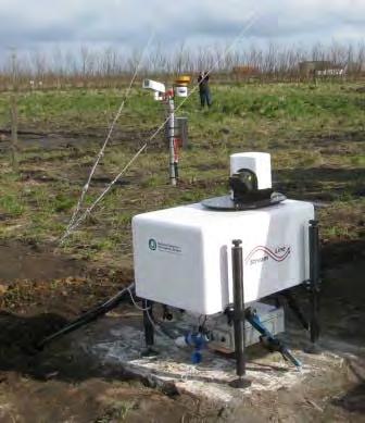
18 MRU: Met Research Unit Ground Based Observations 50m Met. Mast 10m Met. Mast Flux towers up to 50m height, including radiation and soil fluxes Radiosonde launches Radiosonde Cloud Radar 94 Ghz Launch Doppler LIDAR Microwave Radiometers Ground Station Comms. Sun Photometer Clun Valley Lidar Photos: Jeff Norwood-Brown


19 MRU: Met Research Unit Tethered Balloon Turbulence Cloud droplet spectra Winds Tethered Balloon Payload
 Temperature, Pressure Humidity and wind profiles.")
20 MRU: Met Research Unit Unmanned Aerial System UAS Unmanned Aerial System Autonomous ~30 min duration Ceiling (5000ft +) Temperature, Pressure Humidity and wind profiles.
 (other side) 5-port turbulence probe - winds Air sample inlet pipes BBRs Visible Fluxes (and poss IR) Video Cameras")

21 Instrument Payload Humidity WVSS-II (0.4 Hz) (other side) 5-port turbulence probe - winds Air sample inlet pipes BBRs Visible Fluxes (and poss IR) Video Cameras Upward and Rearward Forward Downward Dropsonde (other side) Liquid Water Nevzorov 32Hz Ice Water Nevzorov 32Hz Temperature Rosemount 32Hz Humidity GE, Buck < 1Hz Fast Humidity Total Water 32 Hz Sub-millimetre Radiometer ISMAR IR Interferometer ARIES Lidar Cloud Physics Probes PCASP, CDP, CIP15, CIP100, (AIMMS) Microwave Radiometer MARSS
22 BAe146 Operating Base Airfields below meet operational requirements Airport Halim (Jakarta) ICAO Code Island Runway length Elevation WIHH Java 3000m 25m Hangerage Semerang WAHS Java 2680m 3m Yogyakarta WAHH Java 2200m 107m Bandar-Lampung WILL Sumatra 2500m 86m
23 BAe146 Requirements (these are minimums-the a/c can operate from shorter runways but would suffer payload penalties) Runway Length Runway Width Elevation Cross wind limit Crash Category ft (1800m) 150m < 3000ft (900m) unless longer than 9000ft 45 knts


24 Field campaign overview Night-morning Afternoon Radiosondes R/V Investigator MCS Dropsondes Ground site Christmas Island Supersite Java Shuyi Chen (UoMiami)
Met Office and UK University contribution to YMC Ground instrumentation and modelling
 Met Office and UK University contribution to YMC Ground instrumentation and modelling Cathryn Birch 1,2 Adrian Matthews 3, Steve Woolnough 4, John Marsham 2, Douglas Parker 2, Paul Barret 1, Prince Xavier
Taiwan s South China Sea-Maritime Continent (SCS-MC) Field Campaign ( )
 Field Campaign ( )") Taiwan s South China Sea-Maritime Continent (SCS-MC) Field Campaign (2017-2019) Lead scientists: Po-Hsiung Lin (NTU), Yu-Chieng Liou (NCU/TTFRI) The Maritime Continent (MC) and South China Sea (SCS) acts
Taiwan s South China Sea-Maritime Continent (SCS-MC) Field Campaign (2017-2019) Lead scientists: Po-Hsiung Lin (NTU), Yu-Chieng Liou (NCU/TTFRI) The Maritime Continent (MC) and South China Sea (SCS) acts
Aircraft Observations for ONR DRI and DYNAMO. Coupled Air-sea processes: Q. Wang, D. Khelif, L. Mahrt, S. Chen
 Aircraft Observations for ONR DRI and DYNAMO (NOAA/ONR/NSF) Coupled Air-sea processes: Q. Wang, D. Khelif, L. Mahrt, S. Chen Deep convection/mjo initiation: Dave Jorgensen, S. Chen, R. Houze Aerosol/Cloud
Years of the Maritime Continent (YMC) Science Plan Overview. Chidong Zhang, RSMAS, University of Miami
 Science Plan Overview. Chidong Zhang, RSMAS, University of Miami") Years of the Maritime Continent (YMC) Science Plan Overview Chidong Zhang, RSMAS, University of Miami YMC Motivations - Global Importance: Connections between the Indian and Pacific Oceans, between the
Years of the Maritime Continent (YMC) Science Plan Overview Chidong Zhang, RSMAS, University of Miami YMC Motivations - Global Importance: Connections between the Indian and Pacific Oceans, between the
YMC FOR CLIMATE CHANGE AND AIR QUALITY (CCAQ) CENTER of BMKG
 CENTER of BMKG") Contribution of CENTER for CLIMATE CHANGE and AIR QUALITY (CCAQ) OF BMKG in the Prepared by Dr. Dodo Gunawan Director FIRST INTERNATIONAL SCIENCE AND PLANNING WORKSHOP ON YMC, SINGAPORE 27-30 JANUARY 2015
Contribution of CENTER for CLIMATE CHANGE and AIR QUALITY (CCAQ) OF BMKG in the Prepared by Dr. Dodo Gunawan Director FIRST INTERNATIONAL SCIENCE AND PLANNING WORKSHOP ON YMC, SINGAPORE 27-30 JANUARY 2015
Aircraft and satellite hyperspectral measurements investigating the radiative impact of atmospheric water vapour
 Aircraft and satellite hyperspectral measurements investigating the radiative impact of atmospheric water vapour Stuart Newman and co-workers ITSC-17, Monterey, 14-20 April 2010 Acknowledgements Many thanks
Remote sensing with FAAM to evaluate model performance
 Remote sensing with FAAM to evaluate model performance YOPP-UK Workshop Chawn Harlow, Exeter 10 November 2015 Contents This presentation covers the following areas Introduce myself Focus of radiation research
2.1 OBSERVATIONS AND THE PARAMETERISATION OF AIR-SEA FLUXES DURING DIAMET
 2.1 OBSERVATIONS AND THE PARAMETERISATION OF AIR-SEA FLUXES DURING DIAMET Peter A. Cook * and Ian A. Renfrew School of Environmental Sciences, University of East Anglia, Norwich, UK 1. INTRODUCTION 1.1
INDIAN INSTITUTE OF TROPICAL METEOROLOGY PASHAN, PUNE (An Autonomous Body under the Ministry of Earth Sciences, Govt.
 INDIAN INSTITUTE OF TROPICAL METEOROLOGY PASHAN, PUNE-411008 (An Autonomous Body under the Ministry of Earth Sciences, Govt. of India) Notification NO.: IITM/CAIPEEX-2012-2016/1 CORRIGENDUM TO PUBLIC NOTIFICATION
Met Office physics developments
 Met Office physics developments Ian Boutle, Anke Finnenkoetter, Adrian Hill, Adrian Lock, Jeremy Price and Ben Shipway Presented by Mike Bush 36th EWGLAM and 21 st SRNWP Annual Meeting 2014. 29 th of September
Cathryn Fox, Juliet Pickering Jon Murray, Alan Last.
 Cathryn Fox, Juliet Pickering Jon Murray, Alan Last c.fox11@imperial.ac.uk Campaign overview Cirrus Coupled Cloud-Radiation Experiment Aims: to understand the link between cirrus microphysical properties
FLIGHT FOLDER. Flight No.: B145 Date: 5 Dec 2005 Take Off 10:55:24 Exeter Landing: 13:55:15 Exeter Flight Time 2h59m51. Campaign:
 FLIGHT FOLDER Campaign: Test Flying Operating Area: SW approaches Flight No.: B145 Date: 5 Dec 2005 Take Off 10:55:24 Exeter Landing: 13:55:15 Exeter Flight Time 2h59m51 POB Position Name Institute 1 Captain
Observational campaigns Informing weather and climate model development for aerosols
 Observational campaigns Informing weather and climate model development for aerosols Clouds Aerosol Radiation Interaction and Forcing Year 2017 (CLARIFY) Steven Abel, Paul Barrett, Malcolm Brooks, Hugh
A Live Report from Pre-YMC Campaign in Sumatra
 A Live Report from Pre-YMC Campaign in Sumatra Kunio Yoneyama and Japan & Indonesia Pre-YMC campaign Team - An Update on Japanese Activities since Singapore Workshop - Outline 1) Boreal winter of 2017/18
Atmospheric Lidar The Atmospheric Lidar (ATLID) is a high-spectral resolution lidar and will be the first of its type to be flown in space.
 is a high-spectral resolution lidar and will be the first of its type to be flown in space.") www.esa.int EarthCARE mission instruments ESA s EarthCARE satellite payload comprises four instruments: the Atmospheric Lidar, the Cloud Profiling Radar, the Multi-Spectral Imager and the Broad-Band Radiometer.
www.esa.int EarthCARE mission instruments ESA s EarthCARE satellite payload comprises four instruments: the Atmospheric Lidar, the Cloud Profiling Radar, the Multi-Spectral Imager and the Broad-Band Radiometer.
NARVAL. North Atlantic Rainfall Validation. Christian Klepp, Stephan Bakan, Gerhard Peters, Bjorn Stevens, Lutz Hirsch, Johannes Quaas
 NARVAL North Atlantic Rainfall Validation Christian Klepp, Stephan Bakan, Gerhard Peters, Bjorn Stevens, Lutz Hirsch, Johannes Quaas Klima Campus Meteorologisches Institut, Universität Hamburg Max-Planck-Institut
BMKG Research on Air sea interaction modeling for YMC
 BMKG Research on Air sea interaction modeling for YMC Prof. Edvin Aldrian Director for Research and Development - BMKG First Scientific and Planning Workshop on Year of Maritime Continent, Singapore 27-3
Interpretation of Polar-orbiting Satellite Observations. Atmospheric Instrumentation
 Interpretation of Polar-orbiting Satellite Observations Outline Polar-Orbiting Observations: Review of Polar-Orbiting Satellite Systems Overview of Currently Active Satellites / Sensors Overview of Sensor
TerraMaris: Proposed UK contribution to YMC
 TerraMaris: Proposed UK contribution to YMC Steven Woolnough 1,2 Adrian Matthews 3 (PI), Cathryn Birch 4, John Marsham 4, Nick Klingaman 1,2 Paul Barret 5, Prince Xavier 5 1 National Centre for Atmospheric
Impact of Intraseasonal Variations to the Spatial Distribution of Coastal Heavy Rainbands Intensity During HARIMAU IOP 2011 in the West Sumatera
 Impact of Intraseasonal Variations to the Spatial Distribution of Coastal Heavy Rainbands Intensity During HARIMAU IOP 2011 in the West Sumatera Ardhi Adhary Arbain, Yekti Galihselowati Agency for the
Preliminary Observations of Cloud and Precipitation Characteristics in the Brisbane, Australia Region
 Preliminary Observations of Cloud and Precipitation Characteristics in the Brisbane, Australia Region Sarah Tessendorf April 23, 2008 R. Bruintjes,, J. Wilson, R. Roberts, E. Brandes,, P. May, J. Peter,
University of Notre Dame 2. University of Utah 3. US Army Dugway Proving Grounds 4. University of Virginia 5. Oregon State University 6
 The Mountain Terrain Atmospheric Modeling and Observations (MATERHORN) Program: The First Field Experiment (MATERHORN-X1) H.J.S. Fernando 1, E. Pardyjak 2, D. Zajic 3, S. De Wekker 4 and J. Pace 3 S. Hoch
The Atmospheric Boundary Layer. The Surface Energy Balance (9.2)
") The Atmospheric Boundary Layer Turbulence (9.1) The Surface Energy Balance (9.2) Vertical Structure (9.3) Evolution (9.4) Special Effects (9.5) The Boundary Layer in Context (9.6) What processes control
The Atmospheric Boundary Layer Turbulence (9.1) The Surface Energy Balance (9.2) Vertical Structure (9.3) Evolution (9.4) Special Effects (9.5) The Boundary Layer in Context (9.6) What processes control
Jorg M. Hacker Flinders University Airborne Research Australia - ARA Flinders Centre for Airborne Research - FCAR
 Airborne measurements of the atmospheric structure, evaporation and heat fluxes over the Arafura Sea and the Northern Australian savannah during the TWP-ICE field experiment Jorg M. Hacker Flinders University
Observational Needs for Polar Atmospheric Science
 Observational Needs for Polar Atmospheric Science John J. Cassano University of Colorado with contributions from: Ed Eloranta, Matthew Lazzara, Julien Nicolas, Ola Persson, Matthew Shupe, and Von Walden
Workshop Objective: Plan for actions to move DYNAMO forward need a science and implementation plan
 Dynamics of the MJO (DYNAMO) United States Participation in CINDY2011 (Cooperative Indian Ocean Experiment on Intraseasonal Variability in the Year Background: 2011 Spring 2008: Kunio Yoneyama and Masaki
Wind data collected by a fixed-wing aircraft in the vicinity of a typhoon over the south China coastal waters
 Wind data collected by a fixed-wing aircraft in the vicinity of a typhoon over the south China coastal waters P.W. Chan * and K.K. Hon Hong Kong Observatory, Hong Kong, China Abstract: The fixed-wing aircraft
Weather and the Atmosphere. RAP Short Course
 Weather and the Atmosphere RAP Short Course Syllabus 1) Vertical structure and composition of the atmosphere, basic weather variables 2) Warming Earth and its atmosphere the diurnal and seasonal cycles
Working Group Initiation of Convection
 Working Group Initiation of Convection Ulrich Corsmeier Institut für Meteorologie und Klimaforschung (IMK) Forschungszentrum Karlsruhe/Universität Karlsruhe 2 nd COPS Workshop June 27 June 28, 2005 University
The Terrain-Induced Rotor Experiment (T-REX)
") The Terrain-Induced Rotor Experiment (T-REX) J.D. Doyle 1 and V. Grubišić 2 1 Marine Meteorology Division 2 Desert Research Institute Introduction: The Terrain-induced Rotor Experiment (T-REX) is a coordinated
The Terrain-Induced Rotor Experiment (T-REX) J.D. Doyle 1 and V. Grubišić 2 1 Marine Meteorology Division 2 Desert Research Institute Introduction: The Terrain-induced Rotor Experiment (T-REX) is a coordinated
Meteorological Applications of Unmanned Aerial Systems
 Meteorological Applications of Unmanned Aerial Systems Dr. Astrid Lampert Institute of Flight Guidance Technische Universität Braunschweig Astrid.Lampert@tu-bs.de Outline Unmanned Aerial Systems and payload:
The Green-OAWL (GrOAWL) Airborne Demonstrator for the ATHENA-OAWL Mission Concept: System Progress and Flight Plans
 Airborne Demonstrator for the ATHENA-OAWL Mission Concept: System Progress and Flight Plans") The Green-OAWL (GrOAWL) Airborne Demonstrator for the ATHENA-OAWL Mission Concept: System Progress and Flight Plans International Winds Working Group Workshop 27 June 1 July 2016 Monterey, CA Sara Tucker
The Green-OAWL (GrOAWL) Airborne Demonstrator for the ATHENA-OAWL Mission Concept: System Progress and Flight Plans International Winds Working Group Workshop 27 June 1 July 2016 Monterey, CA Sara Tucker
Years of the Maritime Continent (YMC)
") Years of the Maritime Continent (YMC) < Purpose > Improving our understanding and prediction skill of local multi-scale variability of the MC weather-climate systems and its global impact. < Key > YMC
Years of the Maritime Continent (YMC) < Purpose > Improving our understanding and prediction skill of local multi-scale variability of the MC weather-climate systems and its global impact. < Key > YMC
ARM Climate Research Facility: Goals and Objectives
 ARM Climate Research Facility: Goals and Objectives Provide the national and international scientific community with the infrastructure needed for scientific research on global change Global change research
Recent Examples of NSFfunded Field Campaigns. Jim Moore - Project Manager (NCAR EOL)
") Recent Examples of NSFfunded Field Campaigns Jim Moore - Project Manager (NCAR EOL) Field Campaigns: Where Hypotheses & Observations Meet Recent Examples HIPPO - global operations DC3 - US regional operations
Recent Examples of NSFfunded Field Campaigns Jim Moore - Project Manager (NCAR EOL) Field Campaigns: Where Hypotheses & Observations Meet Recent Examples HIPPO - global operations DC3 - US regional operations
SANDRINE BONY AND BJORN STEVENS
 EUREC 4 A, THE FIELD STUDY: A DRAFT WHITE PAPER SANDRINE BONY AND BJORN STEVENS This draft white paper is meant to sketch out developing plans for the 2019-2020 EUREC 4 A field study. A more complete document
Flight Report Sunday September 21, 2014 Summary
 Flight Report Sunday September 21, 2014 Summary 1 Flight Report: G1 Flight#10 & HALO AC14 1.1 Flight Strategy 2 1.2 Weather Conditions Before the Flight...3 1.3 Weather Conditions During the Flight...6
Improving the Accuracy of Particle Mass Concentration Prediction. Lessons learned from the Eyjafjallajokull crisis and other cases
 Improving the Accuracy of Particle Mass Concentration Prediction Lessons learned from the Eyjafjallajokull crisis and other cases J-L Brenguier Head Météo-France Experimental Research EUFAR Coordinator
Lambertian surface scattering at AMSU-B frequencies:
 Lambertian surface scattering at AMSU-B frequencies: An analysis of airborne microwave data measured over snowcovered surfaces Chawn Harlow, 2nd Workshop on Remote Sensing and Modeling of Land Surface
MACSSIMIZE. Measurements of Arctic Clouds, Snow, and Sea Ice nearby the Marginal Ice ZonE. Principal investigator. Chawn Harlow
 MACSSIMIZE Measurements of Arctic Clouds, Snow, and Sea Ice nearby the Marginal Ice ZonE Principal investigator Chawn Harlow chawn.harlow@metoffice.gov.uk Met Office Areas of contribution Polar atmospheric
Status-quo of COPS Scientific Preparation, Candidate Instrumentation, Workshop Overview
 Status-quo of COPS Scientific Preparation, Candidate Instrumentation, Workshop Overview Andreas Behrendt, Volker Wulfmeyer Institut für Physik und Meteorologie (IPM), Universität Hohenheim, Stuttgart Christoph
Direct radiance validation of IASI - results from JAIVEx
 Direct radiance validation of IASI - results from JAIVEx Stuart Newman, Jonathan Taylor, Fiona Hilton, Andrew Collard, Bill Smith, Allen Larar and many others from the JAIVEx science team ITSC-XVI, Angra
Unmanned Aerial Systems
 Unmanned Aerial Systems Gulf Region Stakeholder Workshop July 17-18, 2007 Mississippi State University Starkville, Mississippi List of Measurement Requirements Fill gaps in measurements of surface and
EPIC2001 was conceived as an intensive process study along and near 95 o W during September and October 2001 used to make measurements of the atmosphe
 EPIC2001 was conceived as an intensive process study along and near 95 o W during September and October 2001 used to make measurements of the atmosphere and ocean in this region. Two aircraft, the National
WLS70: A NEW COMPACT DOPPLER WIND LIDAR FOR BOUNDARY LAYER DYNAMIC STUDIES.
 WLS70: A NEW COMPACT DOPPLER WIND LIDAR FOR BOUNDARY LAYER DYNAMIC STUDIES. VALIDATION RESULTS AND INTERCOMPARISON IN THE FRAME OF THE 8TH CIMO-WMO CAMPAIGN. S. Lolli 1, L.Sauvage 1, M. Boquet 1, 1 Leosphere,
Aircraft and satellite hyperspectral measurements investigating the radiative impact of atmospheric water vapour
 Aircraft and satellite hyperspectral measurements investigating the radiative impact of atmospheric water vapour S. M. Newman 1, A. Larar 2, W. L. Smith 3, K. P. Shine 4, I. V. Ptashnik 4, F. I. Hilton
REVISION OF THE STATEMENT OF GUIDANCE FOR GLOBAL NUMERICAL WEATHER PREDICTION. (Submitted by Dr. J. Eyre)
") WORLD METEOROLOGICAL ORGANIZATION Distr.: RESTRICTED CBS/OPAG-IOS (ODRRGOS-5)/Doc.5, Add.5 (11.VI.2002) COMMISSION FOR BASIC SYSTEMS OPEN PROGRAMME AREA GROUP ON INTEGRATED OBSERVING SYSTEMS ITEM: 4 EXPERT
WORLD METEOROLOGICAL ORGANIZATION Distr.: RESTRICTED CBS/OPAG-IOS (ODRRGOS-5)/Doc.5, Add.5 (11.VI.2002) COMMISSION FOR BASIC SYSTEMS OPEN PROGRAMME AREA GROUP ON INTEGRATED OBSERVING SYSTEMS ITEM: 4 EXPERT
Measurements are infrequent in this region due to difficulty in making both ship- and air-based measurements Natural pristine region far removed from
 PLANNED OBSERVATIONAL CAMPAIGNS OVER THE SOUTHERN OCEANS FOR DETERMINING THE ROLES OF CLOUDS, AEROSOLS AND RADIATION IN THE CLIMATE SYSTEM: SOCRATES, MARCUS & MICRE G. McFarquhar, U. Illinois C. Bretherton,
A "New" Mechanism for the Diurnal Variation of Convection over the Tropical Western Pacific Ocean
 A "New" Mechanism for the Diurnal Variation of Convection over the Tropical Western Pacific Ocean D. B. Parsons Atmospheric Technology Division National Center for Atmospheric Research (NCAR) Boulder,
SkyScanner. Deploying fleets of enduring drones to probe atmospheric phenomena " Kicked off on June the 16 th, 2014
 SkyScanner Deploying fleets of enduring drones to probe atmospheric phenomena " Kicked off on June the 16 th, 2014 Project supported by the STAE foundation, 2014 / 2016 Scope of the project" Overall target:
WATER IN THE ATMOSPHERE
 WATER IN THE ATMOSPHERE During a rainstorm, the air feels moist On a clear, cloudless day, the air may feel dry As the sun heats the land and oceans, the amount of water in the atmosphere changes Water
Flight Report September 12, 2014 Summary
 Flight Report September 12, 2014 Summary 1. HALO Flight Report AC10... 2 1.1 Flight Strategy... 2 1.2 Weather Conditions Before the Flight... 2 1.3 Conditions During the Flight... 5 1. HALO Flight Report
JEPP/HARIMAU radar wind profiler network over the Indonesian maritime continent
 JEPP/HARIMAU radar wind profiler network over the Indonesian maritime continent Shuichi Mori 1, H. Hashiguchi 2, M. Kawashima 3, and M. D. Yamanaka 1 1 RIGC/JAMSTEC, 2 RISH/Kyoto University, 3 ILTS/Hokkaido
The Earth Explorer Missions - Current Status
 EOQ N 66 July 2000 meteorology earthnet remote sensing solid earth future programmes Earth Observation Quarterly The Earth Explorer Missions - Current Status G. Mégie (1) and C.J. Readings (2) (1) Institut
Evaluating Parametrizations using CEOP
 Evaluating Parametrizations using CEOP Paul Earnshaw and Sean Milton Met Office, UK Crown copyright 2005 Page 1 Overview Production and use of CEOP data Results SGP Seasonal & Diurnal cycles Other extratopical
COPS - FRANCE. Proposal funded by ANR, CNES, LEFE/INSU & FINANCIAL SUPPORT: ~700 k k
 COPS - FRANCE Proposal funded by ANR, CNES, LEFE/INSU & Météo-France FINANCIAL SUPPORT: ~700 k k + 24 months of post-doc secured through ANR + 2 x 24 months of post-doc requested from INSU/CNRS PARTICIPANTS
DYNAMO/CINDY Sounding Network
 DYNAMO/CINDY Sounding Network Richard H. Johnson and Paul E. Ciesielski, CSU Masaki Katsumata and Kunio Yoneyama JAMSTEC DYNAMO Workshop, Miami 28 February 2 March 2011 DYNAMO/CINDY Extended Sounding Array
MJO and Diurnal Cycle Experiment (MODEX): The proposed YMC-NCAR aircraft and ground deployment
: The proposed YMC-NCAR aircraft and ground deployment") MJO and Diurnal Cycle Experiment (MODEX): The proposed YMC-NCAR aircraft and ground deployment Courtney Schumacher (Texas A&M), Shuyi Chen and Chidong Zhang (U. Miami) MJO in the MC Weakens over islands
MJO and Diurnal Cycle Experiment (MODEX): The proposed YMC-NCAR aircraft and ground deployment Courtney Schumacher (Texas A&M), Shuyi Chen and Chidong Zhang (U. Miami) MJO in the MC Weakens over islands
Intensive porpoising with a research aircraft to determine atmospheric structure during the SALLJEX and NAME programs
 Intensive porpoising with a research aircraft to determine atmospheric structure during the SALLJEX and NAME programs Michael Douglas National Severe Storms Laboratory Norman, Oklahoma John Mejia CIMMS/University
Aircraft Observations of Tropical Cyclones. Robert Rogers NOAA/AOML Hurricane Research Division Miami, FL
 Aircraft Observations of Tropical Cyclones Robert Rogers NOAA/AOML Hurricane Research Division Miami, FL 1 Motivation Why are observations important? Many important physical processes within hurricanes
An Annual Cycle of Arctic Cloud Microphysics
 An Annual Cycle of Arctic Cloud Microphysics M. D. Shupe Science and Technology Corporation National Oceanic and Atmospheric Administration Environmental Technology Laboratory Boulder, Colorado T. Uttal
Ship-based measurements of cloud microphysics and PBL properties in precipitating trade cumulus clouds during RICO
 Ship-based measurements of cloud microphysics and PBL properties in precipitating trade cumulus clouds during RICO Allen White and Jeff Hare, University of Colorado/CIRES Bruce Albrecht and Pavlos Kolias,
The Development of a Routine Observational Program with Piloted and Unpiloted Aerospace Vehicles: New Directions for ARM UAV
 The Development of a Routine Observational Program with Piloted and Unpiloted Aerospace Vehicles: New Directions for ARM UAV 1. Program Objectives Written by Greg McFarquhar University of Illinois at Urbana-Champaign
Duncan Axisa*, Amit Teller, Roelof Bruintjes, Dan Breed, Roelof Burger National Center for Atmospheric Research (NCAR), Boulder CO USA
, Boulder CO USA") J12.1 AEROSOL - CLOUD INTERACTIONS OVER ISTANBUL, TURKEY AND CENTRAL SAUDI ARABIA Duncan Axisa*, Amit Teller, Roelof Bruintjes, Dan Breed, Roelof Burger National Center for Atmospheric Research (NCAR),
J12.1 AEROSOL - CLOUD INTERACTIONS OVER ISTANBUL, TURKEY AND CENTRAL SAUDI ARABIA Duncan Axisa*, Amit Teller, Roelof Bruintjes, Dan Breed, Roelof Burger National Center for Atmospheric Research (NCAR),
Polar Weather Prediction
 Polar Weather Prediction David H. Bromwich Session V YOPP Modelling Component Tuesday 14 July 2015 A special thanks to the following contributors: Kevin W. Manning, Jordan G. Powers, Keith M. Hines, Dan
MEASUREMENTS AND MODELLING OF WATER VAPOUR SPECTROSCOPY IN TROPICAL AND SUB-ARCTIC ATMOSPHERES.
 MEASUREMENTS AND MODELLING OF WATER VAPOUR SPECTROSCOPY IN TROPICAL AND SUB-ARCTIC ATMOSPHERES. J.P. Taylor, T.J. Hewison, A. McGrath and A. Vance. Airborne Remote Sensing Group, The Met Office, Y70 Building,
APPLICATION OF WEATHER MODIFICTION TECHNOLOGY FOR FLOOD PREVENTION IN JAKARTA 2013
 APPLICATION OF WEATHER MODIFICTION TECHNOLOGY FOR FLOOD PREVENTION IN JAKARTA 2013 Tri Handoko SETO and Heru WIDODO Weather Modification Technology Center, Agency for the Asessment and Application of Technology
Advances in weather and climate science
 Advances in weather and climate science Second ICAO Global Air Navigation Industry Symposium (GANIS/2) 11 to 13 December 2017, Montreal, Canada GREG BROCK Scientific Officer Aeronautical Meteorology Division
07/16/02. Obs: Two strong cells near Miami Anvils blowing toward western ground site Will try E-W legs as far east as we can get FC:
 07/16/02 Obs: Report: Two strong cells near Miami Anvils blowing toward western ground site Will try E-W legs as far east as we can get FC: Summary: Aircraft: Convection should develop mid-afternoon along
Flying through extratropical cyclone Friedhelm
 Flying through extratropical cyclone Friedhelm Laura Baker 1, Oscar Martinez-Alvarado 1, John Methven 1, Peter Knippertz 2 1 Department of Meteorology, University of Reading 2 School of Earth and Environment,
CAST - Coordinated Airborne Studies in the Tropics Overview and aircraft planning. Neil Harris University of Cambridge
 CAST - Coordinated Airborne Studies in the Tropics Overview and aircraft planning Neil Harris University of Cambridge Outline 1. Rationale 2. Capability 3. Flight planning Issues Tropical tropopause layer
The HIAPER Cloud Radar Performance and Observations During Winter Storm Observations of a Nor easter
 The HIAPER Cloud Radar Performance and Observations During Winter Storm Observations of a Nor easter S. Ellis 1*, R. Rauber 2, P. Tsai 1, J. Emmett 1, E. Loew 1, C. Burghart 1, M. Dixon 1, J. Vivekanandan
777 GROUNDSCHOOL Temperature, Stability, Fronts, & Thunderstorms
 777 GROUNDSCHOOL 2018 Temperature, Stability, Fronts, & Thunderstorms The Atmosphere Heating Transfer of heat occurs thru Radiation Advection Convection Matter changes states due to the amount of heat
An overview of Wet Season Forecasting in the Northern Territory
 TWP-ICE Meeting November 2004 An overview of Wet Season Forecasting in the Northern Territory Lori Chappel Northern Territory Regional Forecasting Centre Australian Government Bureau of Meteorology Day
Report of the 3rd COPS & GOP Workshop held on April 10 and 11 at University of Hohenheim
 Report of the 3rd COPS & GOP Workshop held on April 10 and 11 at University of Hohenheim 62 persons participated in the 3rd COPS & GOP Workshop The list of participants and copies of all presentations
Final Weather Unit Study Guide
 Name: Atmospheric Composition and Layers Altitude Atmosphere Composition Troposphere Air Pressure Stratosphere Mesosphere Thermosphere Exosphere Ionosphere Sample Questions: Final Weather Unit Study Guide
C-130 and instrumentation for RICO
 C-130 and instrumentation for RICO Flight schedule and staff limitations Hardpoint allocation and cabin layout Time synchronization Flight issues expectation around convection Sensor groups and expected
Projeto Temático FAPESP 2013/ Climate Ecosystems Atmospheric Composition
 Projeto Temático FAPESP 2013/05014-0 Climate Ecosystems Atmospheric Composition GoAmazon2014/15 Experiment Manaus is a city of 2 million people surrounded by just forest in a radius of 1.500 Km. UNIQUE
Meteorology Today. 1 Aug st Lt Libby Haynes Capt Kim Mevers
 Meteorology 1950 - Today 1 Aug 2018 1 st Lt Libby Haynes Capt Kim Mevers What is meteorology? Is it important to you? Meteorology is the science of the atmosphere embracing both weather and climate. It
Understanding and monitoring Arctic weather using Iqaluit Supersite meteorological observations
 Understanding and monitoring Arctic weather using Iqaluit Supersite meteorological observations Gabrielle Gascon 1, Zen Mariani 2, Armin Dehghan 2, Paul Joe 2, William Burrows 2, and Stella Melo 2 1 Meteorological
On Surface fluxes and Clouds/Precipitation in the Tropical Eastern Atlantic
 On Surface fluxes and Clouds/Precipitation in the Tropical Eastern Atlantic Chris Fairall, NOAA/ESRL Paquita Zuidema, RSMAS/U Miami with contributions from Peter Minnett & Erica Key AMMA Team Meeting Leeds,
Steven Greco* and George D. Emmitt Simpson Weather Associates, Charlottesville, VA. 2. Experiments
 3.3 INVESTIGATION OF FLOWS WITHIN COMPLEX TERRAIN AND ALONG COASTLINES USING AN AIRBORNE DOPPLER WIND LIDAR: OBSERVATIONS AND MODEL COMPARISONS Steven Greco* and George D. Emmitt Simpson Weather Associates,
Federal Aviation Administration
 High Ice Water Content Research International Collaboration and Field Campaign Presented to: FPAW By: Tom Bond Date: Statement of Need Over the past 10+ years, it has been recognized that jet engine powerloss
METEOROLOGY. 1 The average height of the tropopause at 50 N is about A 14 km B 16 km C 11 km D 8 km
 1 The average height of the tropopause at 50 N is about A 14 km B 16 km C 11 km D 8 km 2 In the lower part of the stratosphere the temperature A is almost constant B decreases with altitude C increases
17 August 2016: Russian Aircraft Laboratory available for Arctic Environmental Studies
 17 August 2016: Russian Aircraft Laboratory available for Arctic Environmental Studies A Russian aircraft laboratory is available for scientific use during the Year of Polar Prediction to carry out meteorological
Assimilation of satellite derived soil moisture for weather forecasting
 Assimilation of satellite derived soil moisture for weather forecasting www.cawcr.gov.au Imtiaz Dharssi and Peter Steinle February 2011 SMOS/SMAP workshop, Monash University Summary In preparation of the
MOSAiC Science Implementation The Multidisciplinary drifting Observatory for the Study of Arctic Climate
 MOSAiC Science Implementation The Multidisciplinary drifting Observatory for the Study of Arctic Climate MOSAiC Coordination Team M. Shupe. 13 March 2016 MOSAiC Plan Drifting, interdisciplinary process
Complex Terrain (EDUCT) experiment, conducted by the National Center for Atmospheric
 experiment, conducted by the National Center for Atmospheric") Alex Ameen Shenandoah Trip Paper I visited Shenandoah National Park on April 11, 2009 to investigate the Education in Complex Terrain (EDUCT) experiment, conducted by the National Center for Atmospheric
Alex Ameen Shenandoah Trip Paper I visited Shenandoah National Park on April 11, 2009 to investigate the Education in Complex Terrain (EDUCT) experiment, conducted by the National Center for Atmospheric
ESCI 344 Tropical Meteorology Lesson 7 Temperature, Clouds, and Rain
 ESCI 344 Tropical Meteorology Lesson 7 Temperature, Clouds, and Rain References: Forecaster s Guide to Tropical Meteorology (updated), Ramage Tropical Climatology, McGregor and Nieuwolt Climate and Weather
Preliminary Results from the ATHENA-OAWL Venture Tech Airborne Mission
 Preliminary Results from the ATHENA-OAWL Venture Tech Airborne Mission Sunil Baidar (a, b), Sara Tucker (c), Mike Hardesty (a, b) (a) Cooperative Institute for Research in Environmental Sciences, University
Towards a 3D prediction of fogs on airports with Météo-France operational forecast model AROME
 Towards a 3D prediction of fogs on airports with Météo-France operational forecast model AROME Alain Dabas T. Bergot, C. Lac, F. Burnet, P. Martinet, Y. Bouteloup, F. Bouyssel Météo-France, CNRM Overview
The first tropospheric wind profiler observations of a severe typhoon over a coastal area in South China
 The first tropospheric wind profiler observations of a severe typhoon over a coastal area in South China Lei Li, 1 Pak Wai Chan, 2 Honglong Yang, 1 Rong Zong, 1 Xia Mao, 1 Yin Jiang 1 and Hongbo Zhuang
Eldgos í Eyjafjallajökli hlutverk Veðurstofu Íslands
 Photo: B. Pálmason Eldgos í Eyjafjallajökli hlutverk Veðurstofu Íslands Sigrún Karlsdóttir, Guðrún Nína Petersen, Halldór Björnsson, Halldór Pétursson, Hróbjartur Þorsteinsson, Kristín Vogfjörð og Þórður
Remote Sensing of Precipitation
 Lecture Notes Prepared by Prof. J. Francis Spring 2003 Remote Sensing of Precipitation Primary reference: Chapter 9 of KVH I. Motivation -- why do we need to measure precipitation with remote sensing instruments?
Results from the ARM Mobile Facility
 AMMA Workshop, Toulouse, November 2006 Results from the ARM Mobile Facility Background Anthony Slingo Environmental Systems Science Centre University of Reading, UK Selected results, including a major
Application of microwave radiometer and wind profiler data in the estimation of wind gust associated with intense convective weather
 Application of microwave radiometer and wind profiler data in the estimation of wind gust associated with intense convective weather P W Chan 1 and K H Wong 2 1 Hong Kong Observatory, 134A Nathan Road,
EUMETSAT STATUS AND PLANS
 1 EUM/TSS/VWG/15/826793 07/10/2015 EUMETSAT STATUS AND PLANS François Montagner, Marine Applications Manager, EUMETSAT WMO Polar Space Task Group 5 5-7 October 2015, DLR, Oberpfaffenhofen PSTG Strategic
Climate concepts & climate zones
 Climate concepts & climate zones Internationellt Hållbart Byggande Erik Johansson, HDM, 2012 Contents Climate elements Climate zones Exercise: climate analysis Erik Johansson, HDM 2 Climatic elements Solar
Torben Königk Rossby Centre/ SMHI
 Fundamentals of Climate Modelling Torben Königk Rossby Centre/ SMHI Outline Introduction Why do we need models? Basic processes Radiation Atmospheric/Oceanic circulation Model basics Resolution Parameterizations
HY-2A Satellite User s Guide
 National Satellite Ocean Application Service 2013-5-16 Document Change Record Revision Date Changed Pages/Paragraphs Edit Description i Contents 1 Introduction to HY-2 Satellite... 1 2 HY-2 satellite data