University of Notre Dame 2. University of Utah 3. US Army Dugway Proving Grounds 4. University of Virginia 5. Oregon State University 6
|
|
|
- Naomi Armstrong
- 5 years ago
- Views:
Transcription

1 The Mountain Terrain Atmospheric Modeling and Observations (MATERHORN) Program: The First Field Experiment (MATERHORN-X1) H.J.S. Fernando 1, E. Pardyjak 2, D. Zajic 3, S. De Wekker 4 and J. Pace 3 S. Hoch 2, S. Di Sabatino 1, L. Leo 1, M. Jeglem 2, J. Massey 2, J. Steenburgh 2, D. Jensen 2, V. Kulandaivelu 2, C. Higgins 5, A.Grachev 6 1 University of Notre Dame 2 University of Utah 3 US Army Dugway Proving Grounds 4 University of Virginia 5 Oregon State University 6 CIRES, University of Colorado, and NOAA/ESRL December 3, 2012 This research is supported by Office of Naval Research Award # N

2 MATERHORN-X Team Collaborators IIBR, Israel NCAR University of Bergen, Norway Princeton University University of Vienna, Austria Oregon State University University of Colorado, Boulder
3 MATERHORN Goals 1. Identify and study the limitations of current state-of-thescience mesoscale models for mountain-terrain weather prediction 2. Develop scientific knowledge, technologies and tools to help realize leaps in predictability 3. Identify and address knowledge gaps, e.g. Transition periods Integrate across scales (dissipation scales of turbulence to synoptic scales) Poorly understood physical processes 4. Utilize both traditional and novel techniques to attack the problem
4

5 Diurnal Flow Overview

6 Diurnal Flow Overview Cold Air Drainage Model KLAM 21
7 MATERHORN-I 1. Conducted at the US Army Dugway Proving Grounds from 25 September through 21 October, Consisted of ten 24-hour long IOPs 5 Quiescent (700mb winds < 5ms -1 ) 4 Moderate (700mb winds 5-10ms -1 ) 1 Transitional (dry cold front passage) 6 Nighttime IOPs (1400LT start) 2 Daytime IOPS (0200LT start) 1 Mini-IOP (1200LT-2000LT) 1 Super-IOP (0500LT-1200LT+1day) 3. 2 Precipitation Events (Sept 24, Oct 12)
8 Experiment Details 1. Tower Based Measurements DPG GMAST System Extended Flux Stations (SEB) Suite of supplemental turbulence measurements 2. Ground-Based Remote Sensing Wind LIDARS (UU, UND, ARL) SODAR/RASS (UU, UND) RF Remote Soil moisture Sensing (UND) Ceilometers, FMWC radar 3. Aerial Measurements Twin Otter (CIRPAS, UVA) DataHawk (CU) - UAS Flamingo (UND) UAS 4. Balloon Measurements Radiosonde launches Tethered Balloon soundings 5. Fine Scale Turbulence In Situ Calibration of hot-film probes Flux divergence hot-wire measurements 6. Other Distributed Temperature Sensing (DTS) Infrared Surface Temperature measurements


9 Overview

10 Addressing Near-Surface Small scale issues
11 Overview


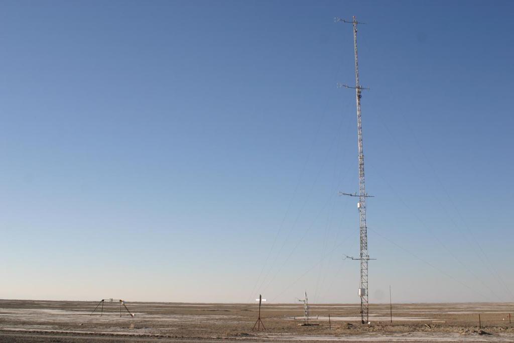
12 East Slope Experiment FLIR Camera H.J.S. Fernando et al. MATERHORN-X1 AGU Fall 2012


13 C. Higgins Oregon State Distributed Temperature Sensing Slight slope, less vegetation Ephemeral stream bed Rocky sloping terrain Tower 2 Tower 3
, a part of the Naval Postgraduate School, Monterey, CA.")

14 Airborn Doppler Over Complex Terrain TODWL (Twin Otter Doppler Wind Lidar) has been operated (since 2002) by CIRPAS (Center for Interdisciplinary Remotely Piloted Aircraft Studies), a part of the Naval Postgraduate School, Monterey, CA. TODWL SCANNER Addition TO Measurements In situ fluxes, surface temperature, Met variables conical scans below the aircraft 2µm coherent detection azimuth angle steps of cm two axis scanner, side door mounted Range:.3 21km depending upon aerosols Accuracy: <.10 m/s in three components


15 Time Synoptic 25 C 0 C N/A Diurnal Temperature Range Potential Temperature, Wind, and RH Time-Height Front IOP9 Super IOP8 Mini IOP7 IOP6 Front 5-10 mm Precip IOP5 IOP4 IOP3 Weak Fropa IOP2 IOP1 IOP0 Front


16 Twin Otter Doppler 9 October afternoon mission Wind LIDAR spatial variability of horizontal wind speed and wind direction along southern leg Spatial variability of vertical winds showing semi-organized structures along southern leg
17 Tethered Balloon Playa Wind & Temperature Structures
18 Tethered Balloon Sage Wind & Temperature Structures H.J.S. Fernando et al. MATERHORN-X1 AGU Fall 2012
 Shallow Down-slope drainage flow b) Complex flow interactions /")
19 LIDAR Observation East Slope of Granite Peak Flow away from / towards LiDAR a) Shallow Down-slope drainage flow b) Complex flow interactions / Mixing
20 Addressing WRF Temperature Biases Operational WRF runs show a consistent morning warm bias, and afternoon cold bias, especially in the first half of the field campaign
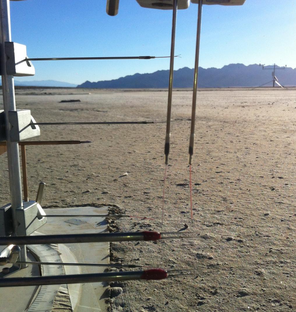
21 Subsurface EFS Measurement Surface 0 cm cm 10 cm 15 cm 25 cm Heat Flux Plates Water Content Reflectometer (except playa) Thermocouple Averaging thermocouple 70 cm Thermal Properties Sensor (1-3 sensors)

22 Addressing WRF Temperature Biases TP01 Thermal property measurement Rain Event Drying Period Dry
23 Radiation Balance Observation Sagebrush vs. Playa
24 Energy Balance Observation Sagebrush vs. Playa
25 1) Successfully completed fall campaign 2) Beginning QC/QA and analysis of the data 3) Preparing for the Spring MATERHORN-II Campaign 4) Working closely with modelers to address specific issues This research was funded by the Office of Naval Research Award # N , Mountain Terrain Atmospheric Modeling and Observations (MATERHORN) Program. Additional support for the Twin Otter was provided by the Environmental Sciences group at the Army Research Office (ARO).
DACA 2013 Davos, Switzerland. University of Utah 2. University of Notre Dame 3. Universita Del Salento, Lecce, Italy 4
 First observations of the effects of shadow fronts on the surface layer dynamics during morning and evening transitions: MATERHORN-X Fall Eric Pardyjak 1, S. Hoch 1, D. Jensen 1, N. Gunawardena 1, S. Di
Wind and turbulence structure in the boundary layer around an isolated mountain: airborne measurements during the MATERHORN field study
 Wind and turbulence structure in the boundary layer around an isolated mountain: airborne measurements during the MATERHORN field study Stephan F.J. De Wekker 1, G.D. Emmitt 2, S. Greco 2, K. Godwin 2,
The Mountain Terrain Atmospheric Modeling and Observations (MATERHORN) Program: A Progress Report
 Program: A Progress Report") The Mountain Terrain Atmospheric Modeling and Observations (MATERHORN) Program: A Progress Report By H.J.S. Fernando, Univ. of Notre Dame, Notre Dame J. P. Hacker, Naval Postgraduate School/NCAR F. K.
The Mountain Terrain Atmospheric Modeling and Observations (MATERHORN) Program: A Progress Report By H.J.S. Fernando, Univ. of Notre Dame, Notre Dame J. P. Hacker, Naval Postgraduate School/NCAR F. K.
The Materhorn: unraveling the intracacies of mountain weather
 Calhoun: The NPS Institutional Archive DSpace Repository Faculty and Researchers Faculty and Researchers Collection 2015-11 The Materhorn: unraveling the intracacies of mountain weather Fernando, H.J.S.
Observations and modeling of the daytime boundary layer around an isolated Mountain
 Observations and modeling of the daytime boundary layer around an isolated Mountain Stephan De Wekker University of Virginia Sandip Pal (post-doc, February 2013) Mark Sghiatti (MS student, July 2013) Nevio
Addressing Diurnal Temperature Biases in the WRF Model
 Addressing Diurnal Temperature Biases in the WRF Model Jeffrey Massey University of Utah Collaborators: Jim Steenburgh, Jason Knievel, Sebastian Hoch, Josh Hacker Long term 2-m temperature verification
Near-surface weather prediction and surface data assimilation: challenges, development, and potential data needs
 Near-surface weather prediction and surface data assimilation: challenges, development, and potential data needs Zhaoxia Pu Department of Atmospheric Sciences University of Utah, Salt Lake City, Utah,
The multiple uses of the Navy's Twin Otter Doppler Wind Lidar (TODWL) for atmospheric research
 for atmospheric research") The multiple uses of the Navy's Twin Otter Doppler Wind Lidar (TODWL) for atmospheric research G. D. Emmitt a, Steve Greco a, Chris O Handley a, Ralph Foster b, Dylan Reif c and Robert Bluth d a Simpson
The multiple uses of the Navy's Twin Otter Doppler Wind Lidar (TODWL) for atmospheric research G. D. Emmitt a, Steve Greco a, Chris O Handley a, Ralph Foster b, Dylan Reif c and Robert Bluth d a Simpson
Opportunities provided by fine-scale meteorological sensor array
 Opportunities provided by fine-scale meteorological sensor array R.M. Randall, C.M Hocut, D.K. Knapp, B.T. MacCall, & J.A. Smith MSA Program Overview Army Challenge Research gaps exist which challenge
Investigation of the Air-Wave-Sea Interaction Modes Using an Airborne Doppler Wind Lidar: Analyses of the HRDL data taken during DYNAMO
 DISTRIBUTION STATEMENT A. Approved for public release; distribution is unlimited. Investigation of the Air-Wave-Sea Interaction Modes Using an Airborne Doppler Wind Lidar: Analyses of the HRDL data taken
Steven Greco* and George D. Emmitt Simpson Weather Associates, Charlottesville, VA. 2. Experiments
 3.3 INVESTIGATION OF FLOWS WITHIN COMPLEX TERRAIN AND ALONG COASTLINES USING AN AIRBORNE DOPPLER WIND LIDAR: OBSERVATIONS AND MODEL COMPARISONS Steven Greco* and George D. Emmitt Simpson Weather Associates,
MOUNTAIN TERRAIN ATMOSPHERIC MODELING AND OBSERVATIONS (MATERHORN) PROGRAM
 PROGRAM") MOUNTAIN TERRAIN ATMOSPHERIC MODELING AND OBSERVATIONS (MATERHORN) PROGRAM by H.J.S. Fernando Environmental Fluid Dynamics Laboratories Department of Civil Engineering & Geological Sciences and Aerospace
MOUNTAIN TERRAIN ATMOSPHERIC MODELING AND OBSERVATIONS (MATERHORN) PROGRAM by H.J.S. Fernando Environmental Fluid Dynamics Laboratories Department of Civil Engineering & Geological Sciences and Aerospace
MATERHORN Field Campaign
 High Resolution Modeling for MATERHORN Field Campaign Applications to Synoptically Driven Flow Zachariah Silver, Reneta Dimitrova, and Tamás Zsedrovits Overview Adjusted WRF model setup Application to
Twin O'er Observa.ons for the MATERHORN. Dave Emmi', Simpson Weather Associates Stephan de Wekker, University of Virginia
 Twin O'er Observa.ons for the MATERHORN Dave Emmi', Simpson Weather Associates Stephan de Wekker, University of Virginia Particle probes TODWL scanner TODWL STV Surface Temperature Sensor CIRPAS Twin O'er
Complex Terrain (EDUCT) experiment, conducted by the National Center for Atmospheric
 experiment, conducted by the National Center for Atmospheric") Alex Ameen Shenandoah Trip Paper I visited Shenandoah National Park on April 11, 2009 to investigate the Education in Complex Terrain (EDUCT) experiment, conducted by the National Center for Atmospheric
Alex Ameen Shenandoah Trip Paper I visited Shenandoah National Park on April 11, 2009 to investigate the Education in Complex Terrain (EDUCT) experiment, conducted by the National Center for Atmospheric
The Atmospheric Boundary Layer. The Surface Energy Balance (9.2)
") The Atmospheric Boundary Layer Turbulence (9.1) The Surface Energy Balance (9.2) Vertical Structure (9.3) Evolution (9.4) Special Effects (9.5) The Boundary Layer in Context (9.6) What processes control
The Atmospheric Boundary Layer Turbulence (9.1) The Surface Energy Balance (9.2) Vertical Structure (9.3) Evolution (9.4) Special Effects (9.5) The Boundary Layer in Context (9.6) What processes control
3.4 Synergisms and comparisons between airborne Doppler Wind Lidar observations and other remote and in-situ wind measurements and model forecasts
 3.4 Synergisms and comparisons between airborne Doppler Wind Lidar observations and other remote and in-situ wind measurements and model forecasts S. Greco*, G.D. Emmitt, S.A. Wood and C. O Handley Simpson
Working Group Initiation of Convection
 Working Group Initiation of Convection Ulrich Corsmeier Institut für Meteorologie und Klimaforschung (IMK) Forschungszentrum Karlsruhe/Universität Karlsruhe 2 nd COPS Workshop June 27 June 28, 2005 University
1. Introduction/Goals and expected outcomes
 Request for use of the NSF Facilities for Education at the University of Colorado Boulder CABL: Characterizing the Atmospheric Boundary Layer Julie K. Lundquist Dept. of Atmospheric and Oceanic Sciences
Summary of ABL group discussions: IHOP Planning meeting National Center for Atmospheric Research Boulder, CO April, 2001
 Summary of ABL group discussions: IHOP Planning meeting National Center for Atmospheric Research Boulder, CO 24-25 April, 2001 Scientific objectives: Summary list: It was agreed that the majority of the
MET 3502 Synoptic Meteorology. Lecture 8: September 16, AIRMASSES, FRONTS and FRONTAL ANALYSIS (2)
") MET 3502 Synoptic Meteorology Lecture 8: September 16, 2010 AIRMASSES, FRONTS and FRONTAL ANALYSIS (2) Identifying a cold front on a surface weather map: 1. Surface front is located at the leading edge
MET 3502 Synoptic Meteorology Lecture 8: September 16, 2010 AIRMASSES, FRONTS and FRONTAL ANALYSIS (2) Identifying a cold front on a surface weather map: 1. Surface front is located at the leading edge
Boundary Layer Science Challenges in the Context of Wind Energy
 Boundary Layer Science Challenges in the Context of Wind Energy WILLIAM J. SHAW 1 Pacific Northwest National Laboratory National Academies of Sciences, Engineering, and Medicine Workshop on the Future
UK Contribution to YMC Observational Field Campaign
 UK Contribution to YMC Observational Field Campaign Land, air and sea, operational modelling YMC 3 rd Workshop, Malaysia 2017 Paul Barrett paul.barrett@metoffice.gov.uk UK Involvement in YMC HotHouse TerraMaris
Large-Eddy Simulations of Tropical Convective Systems, the Boundary Layer, and Upper Ocean Coupling
 DISTRIBUTION STATEMENT A. Approved for public release; distribution is unlimited. Large-Eddy Simulations of Tropical Convective Systems, the Boundary Layer, and Upper Ocean Coupling Eric D. Skyllingstad
Highly resolved turbulence budgets over a desert playa
 Highly resolved turbulence budgets over a desert playa Vigneshwaran Kulandaivelu Derek Jenson & Eric Pardyjak Department of Mechanical Engineering University of Utah Gilad Arwatz & Marcus Hultmark Princeton
The Terrain-Induced Rotor Experiment (T-REX)
") The Terrain-Induced Rotor Experiment (T-REX) J.D. Doyle 1 and V. Grubišić 2 1 Marine Meteorology Division 2 Desert Research Institute Introduction: The Terrain-induced Rotor Experiment (T-REX) is a coordinated
The Terrain-Induced Rotor Experiment (T-REX) J.D. Doyle 1 and V. Grubišić 2 1 Marine Meteorology Division 2 Desert Research Institute Introduction: The Terrain-induced Rotor Experiment (T-REX) is a coordinated
Understanding Near-Surface and In-cloud Turbulent Fluxes in the Coastal Stratocumulus-topped Boundary Layers
 Understanding Near-Surface and In-cloud Turbulent Fluxes in the Coastal Stratocumulus-topped Boundary Layers Qing Wang Meteorology Department, Naval Postgraduate School Monterey, CA 93943 Phone: (831)
Triple Doppler wind lidar observations during the mountain terrain atmospheric modeling and observations field campaign
 Triple Doppler wind lidar observations during the mountain terrain atmospheric modeling and observations field campaign Yansen Wang Christopher M. Hocut Sebastian W. Hoch Edward Creegan Harindra J. S.
The Integration of WRF Model Forecasts for Mesoscale Convective Systems Interacting with the Mountains of Western North Carolina
 Proceedings of The National Conference On Undergraduate Research (NCUR) 2006 The University of North Carolina at Asheville Asheville, North Carolina April 6-8, 2006 The Integration of WRF Model Forecasts
Flight Report Sunday September 21, 2014 Summary
 Flight Report Sunday September 21, 2014 Summary 1 Flight Report: G1 Flight#10 & HALO AC14 1.1 Flight Strategy 2 1.2 Weather Conditions Before the Flight...3 1.3 Weather Conditions During the Flight...6
SURF Progresses Contents
 SURF Progresses Contents 1 5th Workshop: June 21-23, 2017 2 SURF-2016 Summer Experiment 3 Preliminary results 4 Future plan (1) 5 th Workshop: June 21-23, 2017 SURF WS-5: Structure I. New Science Reports
PERFORMANCE OF THE WRF-ARW IN THE COMPLEX TERRAIN OF SALT LAKE CITY
 P2.17 PERFORMANCE OF THE WRF-ARW IN THE COMPLEX TERRAIN OF SALT LAKE CITY Jeffrey E. Passner U.S. Army Research Laboratory White Sands Missile Range, New Mexico 1. INTRODUCTION The Army Research Laboratory
Understanding Near-Surface and In-Cloud Turbulent Fluxes in the Coastal Stratocumulus-Topped Boundary Layers
 Understanding Near-Surface and In-Cloud Turbulent Fluxes in the Coastal Stratocumulus-Topped Boundary Layers Qing Wang Meteorology Department, Naval Postgraduate School Monterey, CA 93943 Phone: (831)
Performance of Radar Wind Profilers, Radiosondes, and Surface Flux Stations at the Southern Great Plains (SGP) Cloud and Radiation Testbed (CART) Site
 Cloud and Radiation Testbed (CART) Site") Performance of Radar Wind Profilers, Radiosondes, and Surface Flux Stations at the Southern Great Plains (SGP) Cloud and Radiation Testbed (CART) Site R. L. Coulter, B. M. Lesht, M. L. Wesely, D. R. Cook,
Performance of Radar Wind Profilers, Radiosondes, and Surface Flux Stations at the Southern Great Plains (SGP) Cloud and Radiation Testbed (CART) Site R. L. Coulter, B. M. Lesht, M. L. Wesely, D. R. Cook,
18B.2 USING THE TLS TO IMPROVE THE UNDERSTANDING OF ATMOSPHERIC TURBULENT PROCESSES
 18B. USING THE TLS TO IMPROVE THE UNDERSTANDING OF ATMOSPHERIC TURBULENT PROCESSES Florence Bocquet 1 (*), Ben B. Balsley 1, Michael Tjernström and Gunilla Svensson ( 1 ) Cooperative Institute for Research
Flight Report September 09, 2014 Summary
 Flight Report September 09, 2014 Summary 1. HALO Flight Report - AC08... 2 1.1 Flight Strategy... 2 1.2 Weather Conditions Before the Flight... 3 1.3 Conditions During the Flight... 5 1. HALO Flight Report
Projeto Temático FAPESP 2013/ Climate Ecosystems Atmospheric Composition
 Projeto Temático FAPESP 2013/05014-0 Climate Ecosystems Atmospheric Composition GoAmazon2014/15 Experiment Manaus is a city of 2 million people surrounded by just forest in a radius of 1.500 Km. UNIQUE
PAM-Station Land-Owner Information Guide Project: CuPIDO, Tucson AZ, Jul/Aug 2006
 PAM-Station Land-Owner Information Guide Project: CuPIDO, Tucson AZ, Jul/Aug 2006 PropVane Anemometer mounted at 10-m Lightning Spike Two-Way radio antenna Sonic Anemometer Solar and Net Radiation sensors.
Large-Eddy Simulations of Tropical Convective Systems, the Boundary Layer, and Upper Ocean Coupling
 DISTRIBUTION STATEMENT A. Approved for public release; distribution is unlimited. Large-Eddy Simulations of Tropical Convective Systems, the Boundary Layer, and Upper Ocean Coupling Eric D. Skyllingstad
Environmental Fluid Dynamics
 Environmental Fluid Dynamics ME EN 7710 Spring 2015 Instructor: E.R. Pardyjak University of Utah Department of Mechanical Engineering Definitions Environmental Fluid Mechanics principles that govern transport,
Understanding and forecasting extreme weather events in Andes lee side: The Relampago opportunity
 Understanding and forecasting extreme weather events in Andes lee side: The Relampago opportunity Ariane Frassoni Center for Weather Forecasting and Climate Studies National Institute for Space Research
Education Ph.D., Atmospheric Sciences, University of Utah M.S., Atmospheric Sciences, University of Utah
 Leah S. Campbell, Ph.D. Postdoctoral Research Associate Department of Atmospheric Sciences University of Utah ------------- Phone: 802-989-9181 E-mail: leah.campbell@utah.edu Education 2017 Ph.D., Atmospheric
REVISION OF THE STATEMENT OF GUIDANCE FOR GLOBAL NUMERICAL WEATHER PREDICTION. (Submitted by Dr. J. Eyre)
") WORLD METEOROLOGICAL ORGANIZATION Distr.: RESTRICTED CBS/OPAG-IOS (ODRRGOS-5)/Doc.5, Add.5 (11.VI.2002) COMMISSION FOR BASIC SYSTEMS OPEN PROGRAMME AREA GROUP ON INTEGRATED OBSERVING SYSTEMS ITEM: 4 EXPERT
WORLD METEOROLOGICAL ORGANIZATION Distr.: RESTRICTED CBS/OPAG-IOS (ODRRGOS-5)/Doc.5, Add.5 (11.VI.2002) COMMISSION FOR BASIC SYSTEMS OPEN PROGRAMME AREA GROUP ON INTEGRATED OBSERVING SYSTEMS ITEM: 4 EXPERT
Remote sensing of meteorological conditions at airports for air quality issues
 Remote sensing of meteorological conditions at airports for air quality issues Stefan Emeis, Klaus Schäfer Institute for Meteorology and Climate Research Atmospheric Environmental Research (IMK-IFU) Forschungszentrum
Oceanic Eddies in the VOCALS Region of the Southeast Pacific Ocean
 Oceanic Eddies in the VOCALS Region of the Southeast Pacific Ocean Outline: Overview of VOCALS Dudley B. Chelton Oregon State University Overview of the oceanographic component of VOCALS Preliminary analysis
The project that I originally selected to research for the OC 3570 course was based on
 Introduction The project that I originally selected to research for the OC 3570 course was based on remote sensing applications of the marine boundary layer and their verification with actual observed
WWRP RDP COPS Coordination Structure Science Questions Status Outlook
 WWRP RDP COPS Volker Wulfmeyer Institute of Physics and Meteorology University of Hohenheim Stuttgart, Germany, the COPS International Science Steering Committee, and the D-PHASE Steering Committee Coordination
SPECIAL PROJECT PROGRESS REPORT
 SPECIAL PROJECT PROGRESS REPORT Progress Reports should be 2 to 10 pages in length, depending on importance of the project. All the following mandatory information needs to be provided. Reporting year
Observational Needs for Polar Atmospheric Science
 Observational Needs for Polar Atmospheric Science John J. Cassano University of Colorado with contributions from: Ed Eloranta, Matthew Lazzara, Julien Nicolas, Ola Persson, Matthew Shupe, and Von Walden
Aircraft Observations for ONR DRI and DYNAMO. Coupled Air-sea processes: Q. Wang, D. Khelif, L. Mahrt, S. Chen
 Aircraft Observations for ONR DRI and DYNAMO (NOAA/ONR/NSF) Coupled Air-sea processes: Q. Wang, D. Khelif, L. Mahrt, S. Chen Deep convection/mjo initiation: Dave Jorgensen, S. Chen, R. Houze Aerosol/Cloud
Forecasting of Optical Turbulence in Support of Realtime Optical Imaging and Communication Systems
 Forecasting of Optical Turbulence in Support of Realtime Optical Imaging and Communication Systems Randall J. Alliss and Billy Felton Northrop Grumman Corporation, 15010 Conference Center Drive, Chantilly,
Met Office and UK University contribution to YMC Ground instrumentation and modelling
 Met Office and UK University contribution to YMC Ground instrumentation and modelling Cathryn Birch 1,2 Adrian Matthews 3, Steve Woolnough 4, John Marsham 2, Douglas Parker 2, Paul Barret 1, Prince Xavier
UNCLASSIFIED R-1 ITEM NOMENCLATURE FY 2013 OCO
 Exhibit R-2, RDT&E Budget Item Justification: PB 213 Army DATE: February 212 COST ($ in Millions) FY 211 FY 212 Base OCO Total FY 214 FY 215 FY 216 FY 217 Cost To Complete Total Cost Total Program Element
Studying 2006 dry and 2007 wet events using surface observations and NCEP Reanalysis
 Studying 2006 dry and 2007 wet events using surface observations and NCEP Reanalysis Xiquan Dong, Baike Xi, and Aaron Kennedy University of North Dakota 1 Objectives 1. How do seasonal cycles of observed
Logistics. Goof up P? R? Can you log in? Requests for: Teragrid yes? NCSA no? Anders Colberg Syrowski Curtis Rastogi Yang Chiu
 Logistics Goof up P? R? Can you log in? Teragrid yes? NCSA no? Requests for: Anders Colberg Syrowski Curtis Rastogi Yang Chiu Introduction to Numerical Weather Prediction Thanks: Tom Warner, NCAR A bit
Interpretation of Polar-orbiting Satellite Observations. Atmospheric Instrumentation
 Interpretation of Polar-orbiting Satellite Observations Outline Polar-Orbiting Observations: Review of Polar-Orbiting Satellite Systems Overview of Currently Active Satellites / Sensors Overview of Sensor
Idaho Power Company s Cloud Seeding Program May 6, 2016
 Idaho Power Company s Cloud Seeding Program May 6, 2016 Shaun Parkinson, PhD, P.E. Overview What is cloud seeding & how is it done Idaho Power s history with cloud seeding Idaho Power s cloud seeding projects
The Properties of Convective Clouds Over the Western Pacific and Their Relationship to the Environment of Tropical Cyclones
 The Properties of Convective Clouds Over the Western Pacific and Their Relationship to the Environment of Tropical Cyclones Principal Investigator: Dr. Zhaoxia Pu Department of Meteorology, University
Real-time PBL analysis system using profilers observations from The New York State Mesonet
 Real-time PBL analysis system using profilers observations from The New York State Mesonet Sarah Lu University at Albany State University of New York Outline Background System description and progress
 Identification of Predictors for Nowcasting Heavy Rainfall In Taiwan --------------------- Part II: Storm Characteristics and Nowcasting Applications Challenges in Developing Nowcasting Applications for
Preliminary Results from the ATHENA-OAWL Venture Tech Airborne Mission
 Preliminary Results from the ATHENA-OAWL Venture Tech Airborne Mission Sunil Baidar (a, b), Sara Tucker (c), Mike Hardesty (a, b) (a) Cooperative Institute for Research in Environmental Sciences, University
Graduate Courses Meteorology / Atmospheric Science UNC Charlotte
 Graduate Courses Meteorology / Atmospheric Science UNC Charlotte In order to inform prospective M.S. Earth Science students as to what graduate-level courses are offered across the broad disciplines of
16. Modern Atmospheric Conditions at the Crater
 16. Modern Atmospheric Conditions at the Crater The crater continues to be modified in the current arid environment, so it is important to understand the meteorological conditions operating today. Those
The Hydrologic Cycle: How Do River Forecast Centers Measure the Parts?
 The Hydrologic Cycle: How Do River Forecast Centers Measure the Parts? Greg Story Meteorologist National Weather Service Fort Worth, TX Overview n Introduction What is the mission of an RFC? n The Hydrologic
Sensitivity of Convective Indices to Humidity Adjustments
 Sensitivity of Convective Indices to Humidity Adjustments M. E. Splitt University of Utah Salt Lake City, Utah R. A. Peppler Cooperative Institute for Mesoscale Meteorological Studies University of Oklahoma
WLS70: A NEW COMPACT DOPPLER WIND LIDAR FOR BOUNDARY LAYER DYNAMIC STUDIES.
 WLS70: A NEW COMPACT DOPPLER WIND LIDAR FOR BOUNDARY LAYER DYNAMIC STUDIES. VALIDATION RESULTS AND INTERCOMPARISON IN THE FRAME OF THE 8TH CIMO-WMO CAMPAIGN. S. Lolli 1, L.Sauvage 1, M. Boquet 1, 1 Leosphere,
Airborne wind lidar observations in the North Atlantic in preparation for the ADM-Aeolus validation
 Airborne wind lidar observations in the North Atlantic in preparation for the ADM-Aeolus validation 18 th Coherent Laser Radar Conference, Boulder, CO, USA O. Reitebuch 1, Ch. Lemmerz 1, U. Marksteiner
A "New" Mechanism for the Diurnal Variation of Convection over the Tropical Western Pacific Ocean
 A "New" Mechanism for the Diurnal Variation of Convection over the Tropical Western Pacific Ocean D. B. Parsons Atmospheric Technology Division National Center for Atmospheric Research (NCAR) Boulder,
Sinéad Louise Farrell1,2,3 Thomas Newman1,2,, Alek Petty 1,2, Jackie Richter-Menge4, Dave McAdoo1,2, Larry Connor2
 Sinéad Louise Farrell1,2,3 Thomas Newman1,2,, Alek Petty 1,2, Jackie Richter-Menge4, Dave McAdoo1,2, Larry Connor2 1 Earth System Science Interdisciplinary Center, University of Maryland, USA 2 NOAA Laboratory
Exploring Gravity Wave Dynamics, Sources, and Predictability in DeepWave
 Exploring Gravity Wave Dynamics, Sources, and Predictability in DeepWave James D. Doyle 1, Stephen D. Eckermann 2, Eric Hendricks 1, Qingfang Jiang 1, P. Alex Reinecke 1, Carolyn A. Reynolds 1, David C.
LAUNCH Concept. Lindenberg Observatory
 Concept Lindenberg Observatory LAUNCH-2005 International Lindenberg Campaign for Assessment of Humidity- and Cloud- Profiling Systems and its Impact on High-Resolution Modelling Objectives Basic Techniques
Operational Forecasting With Very-High-Resolution Models. Tom Warner
 Operational Forecasting With Very-High-Resolution Models Tom Warner Background Since 1997 NCAR Has Been Developing Operational Mesoscale Forecasting Systems for General Meteorological Support at Army Test
Proposal Requesting to use NSF Facilities for Education. Project: TOM: Teaching flow Over Mountains
 Proposal Requesting to use NSF Facilities for Education Project: TOM: Teaching flow Over Mountains Requestor: Drs. Katja Friedrich & Julie Lundquist Department of Atmospheric and Ocean Sciences University
A COMPARISON OF VERY SHORT-TERM QPF S FOR SUMMER CONVECTION OVER COMPLEX TERRAIN AREAS, WITH THE NCAR/ATEC WRF AND MM5-BASED RTFDDA SYSTEMS
 A COMPARISON OF VERY SHORT-TERM QPF S FOR SUMMER CONVECTION OVER COMPLEX TERRAIN AREAS, WITH THE NCAR/ATEC WRF AND MM5-BASED RTFDDA SYSTEMS Wei Yu, Yubao Liu, Tom Warner, Randy Bullock, Barbara Brown and
Lower Troposphere Remote Sensing Activities at UMBC
 Lower Troposphere Remote Sensing Activities at UMBC Ruben Delgado, Belay Demoz Atmospheric Lidar Group Joint Center for Earth Systems Technology University of Maryland, Baltimore County Ad-Hoc Mixing Layer
Winds on Horizontal Scans from Doppler Lidar during T-REX
 Winds on Horizontal Scans from Doppler Lidar during T-REX Aditya Choukulkar 1*, Ronald Calhoun 1, Brian Billings 2, and James Doyle 3 1 Environmental Remote Sensing Group, Arizona State University, Tempe,
Diagnosing the Climatology and Interannual Variability of North American Summer Climate with the Regional Atmospheric Modeling System (RAMS)
") Diagnosing the Climatology and Interannual Variability of North American Summer Climate with the Regional Atmospheric Modeling System (RAMS) Christopher L. Castro and Roger A. Pielke, Sr. Department of
Diagnosing the Climatology and Interannual Variability of North American Summer Climate with the Regional Atmospheric Modeling System (RAMS) Christopher L. Castro and Roger A. Pielke, Sr. Department of
RPAS based observation on the Arctic Boundary Layer during the ISOBAR campaigns on Andøya and Hailuoto
 U N I V E R S I T Y O F B E R G E N RPAS based observation on the Arctic Boundary Layer during the ISOBAR campaigns on Andøya and Hailuoto S Kral 1, J Reuder 1, L Båserud 1, G Urbancic 1,M Jonassen 2;1,
REQUEST FOR ISFF SUPPORT FLOSS NCAR/ATD- April 2001OFAP Meeting
 REQUEST FOR ISFF SUPPORT FLOSS NCAR/ATD- April 2001OFAP Meeting Submitted on 16 January 2001 Corresponding Principal Investigator Name Institution Address Corvallis, OR 97331 Phone 541-737-5691 Larry Mahrt
Request for the use of NSF Facilities for Education. Boundary Structure Experiments with Central Minnesota Profiling II (BaSE CaMP II) submitted by
 submitted by") Request for the use of NSF Facilities for Education Boundary Structure Experiments with Central Minnesota Profiling II (BaSE CaMP II) 1. Introduction submitted by Brian Billings and Rodney Kubesh Department
Request for the use of NSF Facilities for Education Boundary Structure Experiments with Central Minnesota Profiling II (BaSE CaMP II) 1. Introduction submitted by Brian Billings and Rodney Kubesh Department
Simpson Weather Associates
 Simpson Weather Associates ENVIRONMENTAL CON QQCEDSOHH October 8, 2013 809 E. Jefferson Street Charlottesville, Virginia 22902 (434) 979-3571 FAX (434) 979-5599 Defense Technical Information Center 8725
The Deep Propagating Gravity Wave Experiment (DEEPWAVE) Science Overview and Approach
 Science Overview and Approach") The Deep Propagating Gravity Wave Experiment (DEEPWAVE) Science Overview and Approach U.S. PIs: Dave Fritts 1, Ron Smith 2, Mike Taylor 3, Jim Doyle 4, Steve Eckermann 5, and Steve Smith 6 1 GATS, Boulder,
The Deep Propagating Gravity Wave Experiment (DEEPWAVE) Science Overview and Approach U.S. PIs: Dave Fritts 1, Ron Smith 2, Mike Taylor 3, Jim Doyle 4, Steve Eckermann 5, and Steve Smith 6 1 GATS, Boulder,
Taiwan s South China Sea-Maritime Continent (SCS-MC) Field Campaign ( )
 Field Campaign ( )") Taiwan s South China Sea-Maritime Continent (SCS-MC) Field Campaign (2017-2019) Lead scientists: Po-Hsiung Lin (NTU), Yu-Chieng Liou (NCU/TTFRI) The Maritime Continent (MC) and South China Sea (SCS) acts
Taiwan s South China Sea-Maritime Continent (SCS-MC) Field Campaign (2017-2019) Lead scientists: Po-Hsiung Lin (NTU), Yu-Chieng Liou (NCU/TTFRI) The Maritime Continent (MC) and South China Sea (SCS) acts
UFO Database. UFO Dissemination Workshop 23/04/2015. NLR, Amsterdam. Oleg A. Krasnov and the UFO team
 UFO Database UFO Dissemination Workshop 23/0/2015 NLR, Amsterdam Oleg A. Krasnov (o.a.krasnov@tudelft.nl) and the UFO team 2 / Outline UFO Database in Internet Database content Data collections UFO Toulouse
Anthony A. Rockwood Robert A. Maddox
 Anthony A. Rockwood Robert A. Maddox An unusually intense MCS produced large hail and wind damage in northeast Kansas and northern Missouri during the predawn hours of June 7 th, 1982. Takes a look at
Status-quo of COPS Scientific Preparation, Candidate Instrumentation, Workshop Overview
 Status-quo of COPS Scientific Preparation, Candidate Instrumentation, Workshop Overview Andreas Behrendt, Volker Wulfmeyer Institut für Physik und Meteorologie (IPM), Universität Hohenheim, Stuttgart Christoph
Eliezer Kit School of Mechanical Engineering, Tel-Aviv University. In collaboration with: Joe Fernando Chris Hocut Dan Liberzon
 Eliezer Kit School of Mechanical Engineering, Tel-Aviv University In collaboration with: Joe Fernando Chris Hocut Dan Liberzon Motivation and Layout of the talk Fine resolution measurements of atmospheric
MOSAiC Science Implementation The Multidisciplinary drifting Observatory for the Study of Arctic Climate
 MOSAiC Science Implementation The Multidisciplinary drifting Observatory for the Study of Arctic Climate MOSAiC Coordination Team M. Shupe. 13 March 2016 MOSAiC Plan Drifting, interdisciplinary process
Course outline, objectives, workload, projects, expectations
 Course outline, objectives, workload, projects, expectations Introductions Remote Sensing Overview Elements of a remote sensing observing system 1. platform (satellite, surface, etc) 2. experimental design
Correction for Dry Bias in Vaisala Radiosonde RH Data
 Correction for Dry Bias in Vaisala Radiosonde RH Data E. R. Miller, J. Wang, and H. L. Cole National Center for Atmospheric Research Atmospheric Technology Division Boulder, Colorado Abstract Extensive
Assimilation of satellite derived soil moisture for weather forecasting
 Assimilation of satellite derived soil moisture for weather forecasting www.cawcr.gov.au Imtiaz Dharssi and Peter Steinle February 2011 SMOS/SMAP workshop, Monash University Summary In preparation of the
Cyclogenesis in the Western Mediterranean causing Heavy-Rain Events (NEPTUN)
") Cyclogenesis in the Western Mediterranean causing Heavy-Rain Events (NEPTUN) A Proposal for a coordinated mission of the HALO research aircraft in the field Transport processes and atmospheric dynamics
Cyclogenesis in the Western Mediterranean causing Heavy-Rain Events (NEPTUN) A Proposal for a coordinated mission of the HALO research aircraft in the field Transport processes and atmospheric dynamics
Global sea surface temperature October 25 th 2007
 The VOCALS Regional Experiment Aerosols, clouds, and precipitation in southeast Pacific stratocumulus Robert Wood Atmospheric Sciences University of Washington Global sea surface temperature October 25
Climate & Earth System Science. Introduction to Meteorology & Climate. Chapter 05 SOME OBSERVING INSTRUMENTS. Instrument Enclosure.
 Climate & Earth System Science Introduction to Meteorology & Climate MAPH 10050 Peter Lynch Peter Lynch Meteorology & Climate Centre School of Mathematical Sciences University College Dublin Meteorology
Nowcasting and Urban Interactive Modeling Using Robotic and Remotely Sensed Data James Cogan, Robert Dumais, and Yansen Wang
 Nowcasting and Urban Interactive Modeling Using Robotic and Remotely Sensed Data James Cogan, Robert Dumais, and Yansen Wang Meteorological Modeling Branch Battlefield Environment Division Computational
and soils characterizing would be defined.
 Working out of the basic network for monitoring of natural and climatic processes in Siberia M.V. Kabanov, V.V. Zuev, V.А. Krutikov Institute of Monitoring of Climatic and Ecological Systems SB RAS, Tomsk,
Meteorological Applications of Unmanned Aerial Systems
 Meteorological Applications of Unmanned Aerial Systems Dr. Astrid Lampert Institute of Flight Guidance Technische Universität Braunschweig Astrid.Lampert@tu-bs.de Outline Unmanned Aerial Systems and payload:
Regional dry-season climate changes due to three decades of Amazonian deforestation
 In the format provided by the authors and unedited. SUPPLEMENTARY INFORMATION DOI:./NCLIMATE Regional dry-season climate changes due to three decades of Amazonian deforestation Jaya problemkhanna by using
from airborne and surface measurements
 Analysis of the thermal structure of the Ora del Garda wind from airborne and surface measurements Lavinia Laiti, Dino Zardi and Massimiliano de Franceschi Atmospheric Physics Group Department of Civil
Results from the ARM Mobile Facility
 AMMA Workshop, Toulouse, November 2006 Results from the ARM Mobile Facility Background Anthony Slingo Environmental Systems Science Centre University of Reading, UK Selected results, including a major