Lower Troposphere Remote Sensing Activities at UMBC
|
|
|
- Nickolas Marshall
- 5 years ago
- Views:
Transcription


1 Lower Troposphere Remote Sensing Activities at UMBC Ruben Delgado, Belay Demoz Atmospheric Lidar Group Joint Center for Earth Systems Technology University of Maryland, Baltimore County Ad-Hoc Mixing Layer Height Working Group December 6, 2016
2 Research Areas Inversion algorithms, optical, chemical and physical properties of atmospheric aerosols, gases, and clouds. Boundary Layer Dynamics (Air Quality and Wind Energy) Continental and intercontinental plume transport to Eastern US and Caribbean. AOD-PM 2.5 Estimator Development from Ground, Satellite Observations, NWF and Global Models New remote sensing technologies for atmospheric observations.
3 NOAA Office of Education Cooperative Science Centers Center for Earth Systems Science and Remote Sensing Technologies (NOAA-CREST) - CREST Earth System Observing Network (CESON) Enhancement to the CREST Lidar Network with extensive remote and in-situ observation capabilities, and Direct Broadcast Satellite stations for satellites. CCNY (NYC) HU (Hampton, VA) UMBC (Baltimore, MD) UPRM (Mayaguez, PR) - Recognized by the National Science Technology Council Committee on Environment, Natural Resources, and Sustainability as one of three networks in (MPLNET/CLN/NDACC) in report titled Air Quality Observation Systems in the United States. Center for Atmospheric Sciences and Meteorology (NOAA-CASM)
4 Mixing Layer Height (MLH) Diagnostic variable atmospheric transport and dispersion forecasting models. Without realistic MLH models have large errors that result in inadequate public protection against unhealthy air quality. National Research Council has recommended a network of networks 1 After 60 years of remote sensing research, it is astounding that the PBL is not measured regularly throughout its diurnal cycle 1- NRC Observing Weather and Climate from the Ground Up: A Nationwide Network of Networks. Washington, DC: National Academy Press.


5 MLH Algorithms Lidar and radar wind profilers MLH from Covariance Wavelet Transform *Compton et al. (2013), J. Atmos. Ocean. Tech., doi: /jtechd

6 Joint NOAA/ARL-NCEP Field Study Lidar measurements helped to identify problems with automatic PBLH calculation from aircraft profiles (ACARS).
 Lon( ) Aldino 39.5633-76.2039 Edgewood 39.4100-76.2969 Essex 39.3107-76.4744 FairHill 39.")
7 DISCOVER-AQ Examine the representativeness of column optical properties from satellites to ground-based air quality. This campaign was carried out in the Baltimore-Washington metro area during July GroundSite Lat( ) Lon( ) Aldino Edgewood Essex FairHill HU- Beltsville Padonia UMBC


8 Algorithm Comparison DISCOVER AQ Summer Beltsville, MD CL51 Ceilometer MicroPulse Lidar (MPL) Howard Raman Lidar Laser: InGaAs Power: 8.9 mw Wavelength: 910 nm Algorithm: BL-View Laser: Nd-YLF Power: 25 mw Wavelength: 532 nm Algorithm: Wavelet Laser: Nd-YAG Power: 8 W Wavelength: 355 nm Algorithm: Wavelet
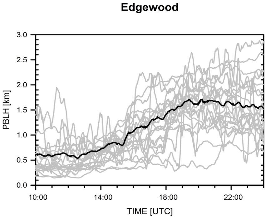
9 Spatial Variability
 dependent of mesoscale processes (i.")
10 Spatial Variability HU-Beltsville and UMBC (Urban sites): Higher surface temperatures and increased convection result in higher afternoon mixing depths and larger diurnal ranges. Edgewood: Greatest variability in the evolution of PBL. Forcing mechanisms (heat and moisture surface fluxes) dependent of mesoscale processes (i.e, bay breeze).


11 Determination of Planetary Boundary Layer Heights From Doppler Wind Lidar Measurements Brian Carroll 1, W. Alan Brewer 2, Timothy Bonin 3, Mike Hardesty 3, Aditya Choukulkar 3 UMBC 1, NOAA ESRL 2, CIRES 3 Developed an intensive fuzzy logic algorithm to estimate boundary layer height Utilizes all Doppler lidar scan types Combines all independent methods of boundary layer height estimation to produce one robust value Algorithm also reports cloud base height and rain events Currently implemented in real-time for multi-year Indianapolis Flux study Products at

12 Recommendation of ASOS Ceilometer PBL Heights for Assimilation/Verification of Forecast Products Belay Demoz 1, Ruben Delgado 1, Kevin Veermesch 1, Keiku Mills-Robertson 1 Ricardo Sakai 2, Dennis Atkinson 3, Michael Hicks 3, Jason Chasse 3 UMBC algorithm being used to retrieve MLH from the NWS Vaisala s CL31 ceilometers, as part of a Proof of Concept CL31 Test bed. MLH heights from CL31 ceilometers to be implemented at nationwide ASOS sites, as support of scientific efforts of the NWS Sterling Field Support Center UMBC 1, Howard University 2, NWS 3
 Microwave Radiometer Profiler (Radiometrics).")
13 Ad-hoc Ceilometer Evaluation Study (ACES) EPA/PAMS evaluation effort with ongoing NWS ceilometer test-bed effort. Intercomparison of Lidar/Ceilometers Soundings (i-met, Vaisala) Microwave Radiometer Profiler (Radiometrics). Comparison with Howard University Beltsville Research Campus
14 Summary Lidar reliable tool for monitoring of the development of the MLH. MLH temporal (hourly/daily) variability within all locations due to synoptic and mesoscale processes. Verification and validation of forecasts and models. Allow proper evaluation of model MLH schemes (assimilation). Assessment of long range transport of natural and anthropogenic aerosols vs. local sources to local air quality. Aid source allocation of particle pollution for during Air Quality Action Days. Evidence for Exclusion of Air Quality Exceedance due to Exceptional Events
15
16 Acknowledgments NOAA/Office of Education Educational Partnership Program NASA, NSF, DOD Maryland Department of the Environment Maryland Energy Administration *The statements contained within the manuscript are not the opinions of the funding agency or the U.S. government, but reflect the author s opinions.
Determination of Mixing Layer Height and ASOS: Testbed, Algorithms and Network
 Determination of Mixing Layer Height and ASOS: Testbed, Algorithms and Network Ruben Delgado, Belay Demoz Atmospheric Lidar Group Joint Center for Earth Systems Technology University of Maryland, Baltimore
Determination of Planetary Boundary Layer Heights on Short Spatial and Temporal Scales from Surface and Airborne Vertical Profilers during DISCOVER AQ
 Determination of Planetary Boundary Layer Heights on Short Spatial and Temporal Scales from Surface and Airborne Vertical Profilers during DISCOVER AQ Ruben Delgado 1, Timothy Berkoff 1,9, Jaime S. Compton
Overview of Maryland s Upper Air Profilers
 Overview of Maryland s Upper Air Profilers Dave Krask, Manager MDE Air Monitoring Program EPA/NACAA Monitoring Meeting January 10, 2013 Martin O Malley, Governor Anthony G. Brown, Lt. Governor Robert M.
AUTOMATIC MONITORING OF BOUNDARY LAYER STRUCTURES WITH CEILOMETER ABSTRACT
 AUTOMATIC MONITORING OF BOUNDARY LAYER STRUCTURES WITH CEILOMETER Christoph Münkel 1, Reijo Roininen 1 Vaisala GmbH, Schnackenburgallee 1d, 55 Hamburg, Germany Phone +9 89 1, Fax +9 89 11, E-mail christoph.muenkel@vaisala.com
5.3 INVESTIGATION OF BOUNDARY LAYER STRUCTURES WITH CEILOMETER USING A NOVEL ROBUST ALGORITHM. Christoph Münkel * Vaisala GmbH, Hamburg, Germany
 5. INVESTIGATION OF BOUNDARY LAYER STRUCTURES WITH CEILOMETER USING A NOVEL ROBUST ALGORITHM Christoph Münkel * Vaisala GmbH, Hamburg, Germany Reijo Roininen Vaisala Oyj, Helsinki, Finland 1. INTRODUCTION
Development of a NYC Meteorological Network with Emphasis on Vertical Wind Profiles in Support of Meteorological and Dispersion Models
 Development of a NYC Meteorological Network with Emphasis on Vertical Wind Profiles in Support of Meteorological and Dispersion Models Mark Arend, D. Santoro, S. Abdelazim B. Gross, F. Moshary, and S.
Kevin Vermeesch* Science Systems and Applications, Inc., Lanham, MD. Mengs Weldegaber University of Maryland Baltimore County
 11.2 MESOSCALE ANALYSIS AND WRF MODEL VERIFICATION OF A LOW-LEVEL JET, BAY BREEZE, AND UNDULAR BORE AT THE HOWARD UNIVERSITY BELSTVILLE RESEARCH CAMPUS Kevin Vermeesch* Science Systems and Applications,
Observation of Smoke and Dust Plume Transport and Impact on the Air Quality Remote Sensing in New York City
 Observation of Smoke and Dust Plume Transport and Impact on the Air Quality Remote Sensing in New York City Yonghua Wu*, Chowdhury Nazmi, Cuiya Li, Daniel Hoyos, Barry Gross, Fred Moshary NOAA-CREST and
Summary of Micro-Pulse Lidar Data Obtained During NASA's DISCOVER-AQ field missions
 Summary of Micro-Pulse Lidar Data Obtained During NASA's DISCOVER-AQ field missions Timothy Berkoff 1,2*, Raymond M Hoff 2, Ruben Delgado 2, Patricia Sawamura 1,2*, Jamie Compton 2, Daniel Orozco 2, John
APPLICATION OF CCNY LIDAR AND CEILOMETERS TO THE STUDY OF AEROSOL TRANSPORT AND PM2.5 MONITORING
 P1.14 APPLICATION OF CCNY LIDAR AND CEILOMETERS TO THE STUDY OF AEROSOL TRANSPORT AND PM2.5 MONITORING Leona A. Charles*, Shuki Chaw, Viviana Vladutescu, Yonghua Wu, Fred Moshary, Barry Gross, Stanley
Update: GRUAN Related Howard University Beltsville Campus.
 Update: GRUAN Related Activities @ Howard University Beltsville Campus. Report by Belay Demoz and Ricardo Sakai Certification: application submitted GRUAN: a site managers view? Benefit?? A Solution (Beltsville
New York Metro-Area Boundary Layer Catalogue: Boundary Layer Height and Stability Conditions from Long-Term Observations
 New York Metro-Area Boundary Layer Catalogue: Boundary Layer Height and Stability Conditions from Long-Term Observations David Melecio-Vázquez*, Jorge E. González-Cruz*, Mark Arend*, Zaw Han*, Mark Dempsey*,
Real-time PBL analysis system using profilers observations from The New York State Mesonet
 Real-time PBL analysis system using profilers observations from The New York State Mesonet Sarah Lu University at Albany State University of New York Outline Background System description and progress
Projects in the Remote Sensing of Aerosols with focus on Air Quality
 Projects in the Remote Sensing of Aerosols with focus on Air Quality Faculty Leads Barry Gross (Satellite Remote Sensing), Fred Moshary (Lidar) Direct Supervision Post-Doc Yonghua Wu (Lidar) PhD Student
Rapid Environmental Changes observed by Remote Sensing Systems in the local vicinity of an unusual Colorado Tornado
 Rapid Environmental Changes observed by Remote Sensing Systems in the local vicinity of an unusual Colorado Tornado 27th Conference on Severe Local Storms 3 7 November 2014, Madison, Wisconsin Steven E.
4.4 COMPARISON OF WIND MEASUREMENTS AT THE HOWARD UNIVERSITY BELTSVILLE RESEARCH CAMPUS. Science Systems and Applications, Inc.
 4.4 COMPARISON OF WIND MEASUREMENTS AT THE HOWARD UNIVERSITY BELTSVILLE RESEARCH CAMPUS Kevin Vermeesch 1 *, Bruce Gentry 2, Grady Koch 3, Matthieu Boquet 4, Huailin Chen 1, Upendra Singh 3, Belay Demoz
The New York City Urban Atmospheric Observatory An Overview
 The New York City Urban Atmospheric Observatory An Overview 84th Annual Meeting of the American Meteorological Society, Special Session on Urban Meteorology 11 Jan 2004 R. Michael Reynolds Brookhaven National
5.1 Use of the Consensus Reference Concept for Testing Radiosondes. Joe Facundo and Jim Fitzgibbon, Office of Operational Systems,
 5. Use of the Consensus Reference Concept for Testing Radiosondes Joe Facundo and Jim Fitzgibbon, Office of Operational Systems, Silver Spring, Maryland and Sterling, Virginia. INTRODUCTION The U. S. has
Summer 2015 Ozone Lidar Observa6ons at Beltsville, MD During Several Air Quality Episodes
 Summer 2015 Ozone Lidar Observa6ons at Beltsville, MD During Several Air Quality Episodes Dr. John Sullivan Thomas McGee, Anne Thompson, Raymond Hoff, Grant Sumnicht, Laurence Twigg Tues Dec. 15, 2015
DOPPLER LIDAR IN THE WIND FORECAST IMPROVEMENT PROJECTS
 EPJ Web of Conferences 11911, 10001 (2016) DOPPLER LIDAR IN THE WIND FORECAST IMPROVEMENT PROJECTS Yelena Pichugina 1, 2*, Robert Banta 2, Alan Brewer 2, Aditya Choukulkar 1, 2, Melinda Marquis 2, Joe
ASSESSMENT OF PM2.5 RETRIEVALS USING A COMBINATION OF SATELLITE AOD AND WRF PBL HEIGHTS IN COMPARISON TO WRF/CMAQ BIAS CORRECTED OUTPUTS
 Presented at the 2 th Annual CMAS Conference, Chapel Hill, NC, October 28-3, 23 ASSESSMENT OF PM2.5 RETRIEVALS USING A COMBINATION OF SATELLITE AOD AND WRF PBL HEIGHTS IN COMPARISON TO WRF/CMAQ BIAS CORRECTED
Working Group Initiation of Convection
 Working Group Initiation of Convection Ulrich Corsmeier Institut für Meteorologie und Klimaforschung (IMK) Forschungszentrum Karlsruhe/Universität Karlsruhe 2 nd COPS Workshop June 27 June 28, 2005 University
DISCOVER-AQ Deriving Information on Surface Conditions from Column and VERtically Resolved Observations Relevant to Air Quality
 DISCOVER-AQ Deriving Information on Surface Conditions from Column and VERtically Resolved Observations Relevant to Air Quality A NASA Earth Venture campaign campaign intended to improve the interpretation
Mixed Layer Heights and Aerosol Products derived from the NASA LaRC Airborne High Spectral Lidar during the First DISCOVER- AQ Field Mission
 Mixed Layer Heights and Aerosol Products derived from the NASA LaRC Airborne High Spectral Resolu@on Lidar during the First DISCOVER- AQ Field Mission Amy Jo Scarino 1,2, Sharon Burton 2, Richard Ferrare
Recent Performance of the NOAA Air Quality Forecasting Capability and the Impact of Driving Meteorology
 Recent Performance of the NOAA Air Quality Forecasting Capability and the Impact of Driving Meteorology http://www.emc.ncep.noaa.gov/mmb/aq Jeff McQueen, Jianping Huang, Ho-Chun Huang, Perry Shafran NCEP/EMC
WLS70: A NEW COMPACT DOPPLER WIND LIDAR FOR BOUNDARY LAYER DYNAMIC STUDIES.
 WLS70: A NEW COMPACT DOPPLER WIND LIDAR FOR BOUNDARY LAYER DYNAMIC STUDIES. VALIDATION RESULTS AND INTERCOMPARISON IN THE FRAME OF THE 8TH CIMO-WMO CAMPAIGN. S. Lolli 1, L.Sauvage 1, M. Boquet 1, 1 Leosphere,
Observational Needs for Polar Atmospheric Science
 Observational Needs for Polar Atmospheric Science John J. Cassano University of Colorado with contributions from: Ed Eloranta, Matthew Lazzara, Julien Nicolas, Ola Persson, Matthew Shupe, and Von Walden
The Use of Lidar Technology for Measuring Mixing Heights under the Photochemical Assessment Monitoring Stations (PAMS) Program
 Program") The Use of Lidar Technology for Measuring Mixing Heights under the Photochemical Assessment Monitoring Stations (PAMS) Program Leveraging Research under the Joint DISCOVER-AQ/FRAPPÉ Missions by James J.
The Use of Lidar Technology for Measuring Mixing Heights under the Photochemical Assessment Monitoring Stations (PAMS) Program Leveraging Research under the Joint DISCOVER-AQ/FRAPPÉ Missions by James J.
Simulation testbed for the assessment of space-based wind measuring systems
 Simulation testbed for the assessment of space-based wind measuring systems S. A. Wood, G. D. Emmitt and Steve Greco Simpson Weather Associates, 809 E. Jefferson St., Charlottesville, VA 22902 ABSTRACT
Progress on GCOS-China CMA IOS Development Plan ( ) PEI, Chong Department of Integrated Observation of CMA 09/25/2017 Hangzhou, China
 PEI, Chong Department of Integrated Observation of CMA 09/25/2017 Hangzhou, China") Progress on GCOS-China CMA IOS Development Plan (2016-2020) PEI, Chong Department of Integrated Observation of CMA 09/25/2017 Hangzhou, China 1. Progress on GCOS-China 1 Organized GCOS-China GCOS-China
Progress on GCOS-China CMA IOS Development Plan (2016-2020) PEI, Chong Department of Integrated Observation of CMA 09/25/2017 Hangzhou, China 1. Progress on GCOS-China 1 Organized GCOS-China GCOS-China
M. A. Tzortziou Earth System Science Interdisciplinary Center, University of Maryland, College Park, MD, USA
 DOI 10.1007/s10874-013-9254-9 Effects of local meteorology and aerosols on ozone and nitrogen dioxide retrievals from OMI and pandora spectrometers in Maryland, USA during DISCOVER-AQ 2011 Andra J. Reed
SAMPLE. SITE SPECIFIC WEATHER ANALYSIS Slip and Fall on Snow/Ice. Robinson, Smith & Walsh. John Smith. July 1, 2017 REFERENCE:
 SAMPLE SITE SPECIFIC WEATHER ANALYSIS Slip and Fall on Snow/Ice PREPARED FOR: Robinson, Smith & Walsh John Smith July 1, 2017 REFERENCE: MARIE DAVIDSON / 202301 1 Jackson Drive, Hicksville, NY 11801 CompuWeather
Preliminary Results from the ATHENA-OAWL Venture Tech Airborne Mission
 Preliminary Results from the ATHENA-OAWL Venture Tech Airborne Mission Sunil Baidar (a, b), Sara Tucker (c), Mike Hardesty (a, b) (a) Cooperative Institute for Research in Environmental Sciences, University
Course outline, objectives, workload, projects, expectations
 Course outline, objectives, workload, projects, expectations Introductions Remote Sensing Overview Elements of a remote sensing observing system 1. platform (satellite, surface, etc) 2. experimental design
NOAA CREST
 NOAA CREST 2016-2021 Reza Khanbilvardi NOAA CREST Center, The City College of CUNY, NY CICS Science Conference University of Maryland, College Park, MD November 29-1 December, 2016 NOAA Cooperative Science
LAUNCH Concept. Lindenberg Observatory
 Concept Lindenberg Observatory LAUNCH-2005 International Lindenberg Campaign for Assessment of Humidity- and Cloud- Profiling Systems and its Impact on High-Resolution Modelling Objectives Basic Techniques
A Comparison of Clear-Sky Emission Models with Data Taken During the 1999 Millimeter-Wave Radiometric Arctic Winter Water Vapor Experiment
 A Comparison of Clear-Sky Emission Models with Data Taken During the 1999 Millimeter-Wave Radiometric Arctic Winter Water Vapor Experiment E. R. Westwater, Y. Han, A. Gasiewski, and M. Klein Cooperative
Polar Weather Prediction
 Polar Weather Prediction David H. Bromwich Session V YOPP Modelling Component Tuesday 14 July 2015 A special thanks to the following contributors: Kevin W. Manning, Jordan G. Powers, Keith M. Hines, Dan
Projeto Temático FAPESP 2013/ Climate Ecosystems Atmospheric Composition
 Projeto Temático FAPESP 2013/05014-0 Climate Ecosystems Atmospheric Composition GoAmazon2014/15 Experiment Manaus is a city of 2 million people surrounded by just forest in a radius of 1.500 Km. UNIQUE
Progress and Plan of China Xilinhot GRUAN works. Zhao Peitao Meteorological Observation Center (MOC) of CMA
 of CMA") Progress and Plan of China Xilinhot GRUAN works Zhao Peitao Email: peitaozhao@163.com Meteorological Observation Center (MOC) of CMA 2017-6-14 1 Strategic work plan 2 Operation level progress 3 Technical
Progress and Plan of China Xilinhot GRUAN works Zhao Peitao Email: peitaozhao@163.com Meteorological Observation Center (MOC) of CMA 2017-6-14 1 Strategic work plan 2 Operation level progress 3 Technical
Mixing height over London: spatio-temporal characteristics observed by Ceilometer networks
 Department of Meteorology Mixing height over London: spatio-temporal characteristics observed by Ceilometer networks Simone Kotthaus 1, Charley Stockdale 2, Cristina Charlton-Perez 3, Ewan O'Connor 1,4,
European ceilometer and lidar networks for aerosol profiling and aviation safety the German contribution
 European ceilometer and lidar networks for aerosol profiling and aviation safety the German contribution Werner Thomas Deutscher Wetterdienst (DWD) Hohenpeissenberg Meteorological Observatory www.dwd.de/ceilomap
Understanding and monitoring Arctic weather using Iqaluit Supersite meteorological observations
 Understanding and monitoring Arctic weather using Iqaluit Supersite meteorological observations Gabrielle Gascon 1, Zen Mariani 2, Armin Dehghan 2, Paul Joe 2, William Burrows 2, and Stella Melo 2 1 Meteorological
EPIC2001 was conceived as an intensive process study along and near 95 o W during September and October 2001 used to make measurements of the atmosphe
 EPIC2001 was conceived as an intensive process study along and near 95 o W during September and October 2001 used to make measurements of the atmosphere and ocean in this region. Two aircraft, the National
SURF Progresses Contents
 SURF Progresses Contents 1 5th Workshop: June 21-23, 2017 2 SURF-2016 Summer Experiment 3 Preliminary results 4 Future plan (1) 5 th Workshop: June 21-23, 2017 SURF WS-5: Structure I. New Science Reports
Creating Meteorology for CMAQ
 Creating Meteorology for CMAQ Tanya L. Otte* Atmospheric Sciences Modeling Division NOAA Air Resources Laboratory Research Triangle Park, NC * On assignment to the National Exposure Research Laboratory,
1.2 UTILIZING MODIS SATELLITE OBSERVATIONS IN NEAR-REAL-TIME TO IMPROVE AIRNow NEXT DAY FORECAST OF FINE PARTICULATE MATTER, PM2.5
 1.2 UTILIZING MODIS SATELLITE OBSERVATIONS IN NEAR-REAL-TIME TO IMPROVE AIRNow NEXT DAY FORECAST OF FINE PARTICULATE MATTER, PM2.5 James Szykman*, John White US EPA, Office of Air Quality Planning and
REVISION OF THE STATEMENT OF GUIDANCE FOR GLOBAL NUMERICAL WEATHER PREDICTION. (Submitted by Dr. J. Eyre)
") WORLD METEOROLOGICAL ORGANIZATION Distr.: RESTRICTED CBS/OPAG-IOS (ODRRGOS-5)/Doc.5, Add.5 (11.VI.2002) COMMISSION FOR BASIC SYSTEMS OPEN PROGRAMME AREA GROUP ON INTEGRATED OBSERVING SYSTEMS ITEM: 4 EXPERT
WORLD METEOROLOGICAL ORGANIZATION Distr.: RESTRICTED CBS/OPAG-IOS (ODRRGOS-5)/Doc.5, Add.5 (11.VI.2002) COMMISSION FOR BASIC SYSTEMS OPEN PROGRAMME AREA GROUP ON INTEGRATED OBSERVING SYSTEMS ITEM: 4 EXPERT
Assimilation of Satellite Cloud and Precipitation Observations in NWP Models: Report of a Workshop
 Assimilation of Satellite Cloud and Precipitation Observations in NWP Models: Report of a Workshop George Ohring and Fuzhong Weng Joint Center for Satellite Data Assimilation Ron Errico NASA/GSFC Global
Lecture 4b: Meteorological Satellites and Instruments. Acknowledgement: Dr. S. Kidder at Colorado State Univ.
 Lecture 4b: Meteorological Satellites and Instruments Acknowledgement: Dr. S. Kidder at Colorado State Univ. US Geostationary satellites - GOES (Geostationary Operational Environmental Satellites) US
Thermodynamic Profiling Technology Workshop
 Thermodynamic Profiling Technology Workshop Characteristics of a Testbed: NOAA/NWS Testbed Implementation David Helms Office of Science and Technology NOAA National Weather Service Boulder, Colorado April
Remote sensing of meteorological conditions at airports for air quality issues
 Remote sensing of meteorological conditions at airports for air quality issues Stefan Emeis, Klaus Schäfer Institute for Meteorology and Climate Research Atmospheric Environmental Research (IMK-IFU) Forschungszentrum
THE INFLUENCE OF HIGHLY RESOLVED SEA SURFACE TEMPERATURES ON METEOROLOGICAL SIMULATIONS OFF THE SOUTHEAST US COAST
 THE INFLUENCE OF HIGHLY RESOLVED SEA SURFACE TEMPERATURES ON METEOROLOGICAL SIMULATIONS OFF THE SOUTHEAST US COAST Peter Childs, Sethu Raman, and Ryan Boyles State Climate Office of North Carolina and
SNOWFALL RATE RETRIEVAL USING AMSU/MHS PASSIVE MICROWAVE DATA
 SNOWFALL RATE RETRIEVAL USING AMSU/MHS PASSIVE MICROWAVE DATA Huan Meng 1, Ralph Ferraro 1, Banghua Yan 2 1 NOAA/NESDIS/STAR, 5200 Auth Road Room 701, Camp Spring, MD, USA 20746 2 Perot Systems Government
NOAA Research and Development Supporting NextGen. Darien Davis NOAA Office of Oceanic and Atmospheric Research June 22, 2009
 NOAA Research and Development Supporting NextGen Darien Davis Darien.l.davis@noaa.gov NOAA Office of Oceanic and Atmospheric Research June 22, 2009 FAA/NOAA Coordination Developing an integrated science
Met Office and UK University contribution to YMC Ground instrumentation and modelling
 Met Office and UK University contribution to YMC Ground instrumentation and modelling Cathryn Birch 1,2 Adrian Matthews 3, Steve Woolnough 4, John Marsham 2, Douglas Parker 2, Paul Barret 1, Prince Xavier
SAMPLE. SITE SPECIFIC WEATHER ANALYSIS Rainfall Report. Bevins Engineering, Inc. Susan M. Benedict. July 1, 2017 REFERENCE:
 SAMPLE SITE SPECIFIC WEATHER ANALYSIS Rainfall Report PREPARED FOR: Bevins Engineering, Inc. Susan M. Benedict July 1, 2017 REFERENCE: DUBOWSKI RESIDENCE / FILE# 11511033 1500 Water Street, Pensacola,
ABB Remote Sensing Atmospheric Emitted Radiance Interferometer AERI system overview. Applications
 The ABB Atmospheric Emitted Radiance Interferometer AERI provides thermodynamic profiling, trace gas detection, atmospheric cloud aerosol study, air quality monitoring, and more. AERI high level overview
Results from the Atmosphere & Climate projects in Dragon-3
 Results from the Atmosphere & Climate projects in Dragon-3 R.J. van der A, J. Bai, A. Ding, N. Hao, Y. Xue, C. Varotsos, R. Ma, S. Loiselle, F. Huang, V. Sofieva, Y. Liu, H. Boesch, Z. Liu, O. Reitebuch,
Seasonal Aerosol Vertical Distribution and Optical Properties over North China Xing-xing GAO, Yan CHEN, Lei ZHANG * and Wu ZHANG
 2017 International Conference on Energy, Environment and Sustainable Development (EESD 2017) ISBN: 978-1-60595-452-3 Seasonal Aerosol Vertical Distribution and Optical Properties over North China Xing-xing
SAMPLE. SITE SPECIFIC WEATHER ANALYSIS Wind Report. Robinson, Smith & Walsh. John Smith. July 1, 2017 REFERENCE: 1 Maple Street, Houston, TX 77034
 SAMPLE SITE SPECIFIC WEATHER ANALYSIS Wind Report PREPARED FOR: Robinson, Smith & Walsh John Smith July 1, 2017 REFERENCE: JACK HIGGINS / 4151559-01 1 Maple Street, Houston, TX 77034 CompuWeather Sample
INSITU project within AeroCom Phase III: Description and Model Output Request
 INSITU project within AeroCom Phase III: Description and Model Output Request Primary Contact: Secondary Contacts: Betsy Andrews (betsy.andrews@noaa.gov) Lauren Schmeisser (lauren.schmeisser@noaa.gov),
NOAA s Air Quality Forecasting Activities. Steve Fine NOAA Air Quality Program
 NOAA s Air Quality Forecasting Activities Steve Fine NOAA Air Quality Program Introduction Planned Capabilities Initial: 1-day 1 forecast guidance for ozone Develop and validate in Northeastern US September,
Ship-Based Measurements of Cloud Microphysics and PBL Properties in Precipitating Trade Cumuli During RICO
 Ship-Based Measurements of Cloud Microphysics and PBL Properties in Precipitating Trade Cumuli During RICO Institutions: University of Miami; University of Colorado; NOAA ETL Investigators: P. Kollias
Regional methane emissions estimates in northern Pennsylvania gas fields using a mesoscale atmospheric inversion system
 Regional methane emissions estimates in northern Pennsylvania gas fields using a mesoscale atmospheric inversion system Thomas Lauvaux1, A. Deng1, B. Gaudet1, S. J. Richardson1, N. L. Miles1, J. N. Ciccarelli1,2,
WMO OSCAR. Observing Systems Capability Analysis and Review Tool A building block of Rolling Requirements Review
 WMO OSCAR Observing Systems Capability Analysis and Review Tool A building block of Rolling Requirements Review Quantitative user-defined requirements for observation of physical variables in application
NOAA s Capabilities in Wind Energy
 NCAR-Xcel-NOAA Meeting May 11-12, 2010 Boulder, CO NOAA s Capabilities in Wind Energy Melinda Marquis, Ph.D. NOAA Earth System Research Laboratory Outline NOAA has a potential role in improving wind forecasting
Network of Direct Broadcast Antenna Systems to Provide Real-Time Infrared and Microwave Sounder Data to NOAA for Numerical Weather Prediction
 Sandy Supplemental Grant Recipient Quarterly Progress Report Network of Direct Broadcast Antenna Systems to Provide Real-Time Infrared and Microwave Sounder Data to NOAA for Numerical Award Number: NA13NES4830007
Egypt-NOAA Cooperation: Advancing our Environmental Science, Technology, and Education
 Egypt-NOAA Cooperation: Advancing our Environmental Science, Technology, and Education T. G. Onsager NOAA Space Weather Prediction Center and NWS International Activities Office (one-year detail) Terry.Onsager@noaa.gov
Study of the Influence of Thin Cirrus Clouds on Satellite Radiances Using Raman Lidar and GOES Data
 Study of the Influence of Thin Cirrus Clouds on Satellite Radiances Using Raman Lidar and GOES Data D. N. Whiteman, D. O C. Starr, and G. Schwemmer National Aeronautics and Space Administration Goddard
Atmospheric Science (ATS)
") The University of Alabama in Huntsville 1 Atmospheric Science (ATS) ATS 501 - SURVEY OF ATMOSPHERIC SCIENCE General survey of the field of atmospheric science includes thermodynamics, atmospheric dynamics,
The University of Alabama in Huntsville 1 Atmospheric Science (ATS) ATS 501 - SURVEY OF ATMOSPHERIC SCIENCE General survey of the field of atmospheric science includes thermodynamics, atmospheric dynamics,
ATMOSPHERIC SCIENCE-ATS (ATS)
") Atmospheric Science-ATS (ATS) 1 ATMOSPHERIC SCIENCE-ATS (ATS) Courses ATS 150 Science of Global Climate Change Credits: 3 (3-0-0) Physical basis of climate change. Energy budget of the earth, the greenhouse
Atmospheric Science-ATS (ATS) 1 ATMOSPHERIC SCIENCE-ATS (ATS) Courses ATS 150 Science of Global Climate Change Credits: 3 (3-0-0) Physical basis of climate change. Energy budget of the earth, the greenhouse
Module 11: Meteorology Topic 5 Content: Weather Maps Notes
 Introduction A variety of weather maps are produced by the National Weather Service and National Oceanographic Atmospheric Administration. These maps are used to help meteorologists accurately predict
Atmospheric Profiles Over Land and Ocean from AMSU
 P1.18 Atmospheric Profiles Over Land and Ocean from AMSU John M. Forsythe, Kevin M. Donofrio, Ron W. Kessler, Andrew S. Jones, Cynthia L. Combs, Phil Shott and Thomas H. Vonder Haar DoD Center for Geosciences
Recent lidar measurements from AWIPEV
 Recent lidar measurements from AWIPEV By Christoph Ritter AWI Potsdam Aerosol and BL measurements Aims aerosol: (remote sensing sun/star-photometer, Raman lidar) Continue long-term measurements Participate
Assimilation of Mesoscale Observations for use in Numerical Weather Prediction
 Assimilation of Mesoscale Observations for use in Numerical Weather Prediction Steve Koch Thermodynamic Profiling Technologies Workshop Boulder 12 14 April 2011 Important Questions (from 2003 USWRP Mesoscale
Leveraging Existing and Future In-Situ Observational Networks
 Leveraging Existing and Future In-Situ Observational Networks John Horel* Department of Atmospheric Sciences University of Utah john.horel@utah.edu * COI Disclosure: equity stake in Synoptic Data Corp.
Opportunities provided by fine-scale meteorological sensor array
 Opportunities provided by fine-scale meteorological sensor array R.M. Randall, C.M Hocut, D.K. Knapp, B.T. MacCall, & J.A. Smith MSA Program Overview Army Challenge Research gaps exist which challenge
Land Data Assimilation at NCEP NLDAS Project Overview, ECMWF HEPEX 2004
 Dag.Lohmann@noaa.gov, Land Data Assimilation at NCEP NLDAS Project Overview, ECMWF HEPEX 2004 Land Data Assimilation at NCEP: Strategic Lessons Learned from the North American Land Data Assimilation System
Boundary Layer Structure, Turbulence and Shallow Cumulus Observations During RICO 2005
 Boundary Layer Structure, Turbulence and Shallow Cumulus Observations During RICO 2005 A Thesis Defense By Shaunna Donaher University of Miami, RSMAS April 9 th, 2007 Introduction/ Motivation Previous
Country Report - Singapore
 Country Report - Singapore The 5th Meeting of the Coordinating Group Vladivostok city, Russky Island, Russia Far Eastern Federal University of the RA II WIGOS Satellite Project 21 October 2017 Outline
Years of the Maritime Continent (YMC) Science Plan Overview. Chidong Zhang, RSMAS, University of Miami
 Science Plan Overview. Chidong Zhang, RSMAS, University of Miami") Years of the Maritime Continent (YMC) Science Plan Overview Chidong Zhang, RSMAS, University of Miami YMC Motivations - Global Importance: Connections between the Indian and Pacific Oceans, between the
Years of the Maritime Continent (YMC) Science Plan Overview Chidong Zhang, RSMAS, University of Miami YMC Motivations - Global Importance: Connections between the Indian and Pacific Oceans, between the
University of Notre Dame 2. University of Utah 3. US Army Dugway Proving Grounds 4. University of Virginia 5. Oregon State University 6
 The Mountain Terrain Atmospheric Modeling and Observations (MATERHORN) Program: The First Field Experiment (MATERHORN-X1) H.J.S. Fernando 1, E. Pardyjak 2, D. Zajic 3, S. De Wekker 4 and J. Pace 3 S. Hoch
WWRP RDP COPS Coordination Structure Science Questions Status Outlook
 WWRP RDP COPS Volker Wulfmeyer Institute of Physics and Meteorology University of Hohenheim Stuttgart, Germany, the COPS International Science Steering Committee, and the D-PHASE Steering Committee Coordination
How does NASA study hurricanes? 17 August 2015, by Max Gleber
 How does NASA study hurricanes? 17 August 2015, by Max Gleber Hurricanes are the most powerful weather event on Earth. NASA's expertise in space and scientific exploration contributes to essential services
The Green-OAWL (GrOAWL) Airborne Demonstrator for the ATHENA-OAWL Mission Concept: System Progress and Flight Plans
 Airborne Demonstrator for the ATHENA-OAWL Mission Concept: System Progress and Flight Plans") The Green-OAWL (GrOAWL) Airborne Demonstrator for the ATHENA-OAWL Mission Concept: System Progress and Flight Plans International Winds Working Group Workshop 27 June 1 July 2016 Monterey, CA Sara Tucker
The Green-OAWL (GrOAWL) Airborne Demonstrator for the ATHENA-OAWL Mission Concept: System Progress and Flight Plans International Winds Working Group Workshop 27 June 1 July 2016 Monterey, CA Sara Tucker
Spaceborne Wind Lidar Observations by Aeolus Data Products and Pre-Launch Validation with an Airborne Instrument
 DRAGON 3 Project ID 10532 Cal/Val Spaceborne Wind Lidar Observations by Aeolus Data Products and Pre-Launch Validation with an Airborne Instrument Reitebuch Oliver, Lemmerz Christian, Marksteiner Uwe,
Measurements are infrequent in this region due to difficulty in making both ship- and air-based measurements Natural pristine region far removed from
 PLANNED OBSERVATIONAL CAMPAIGNS OVER THE SOUTHERN OCEANS FOR DETERMINING THE ROLES OF CLOUDS, AEROSOLS AND RADIATION IN THE CLIMATE SYSTEM: SOCRATES, MARCUS & MICRE G. McFarquhar, U. Illinois C. Bretherton,
P.083 SEVERE WEATHER EVENTS DETECTED BY PUERTO RICO S TROPINET DUAL-POLARIZED DOPPLER X-BAND RADARS NETWORK
 P.083 SEVERE WEATHER EVENTS DETECTED BY PUERTO RICO S TROPINET DUAL-POLARIZED DOPPLER X-BAND RADARS NETWORK Leyda León, José Colom, Carlos Wah University of Puerto Rico, Mayagüez Campus, Mayagüez, PR 1.
EPA AIRNow Program. Air Quality Index Reporting and Forecasts. Prepared by: John E. White
 EPA AIRNow Program Air Quality Index Reporting and Forecasts Prepared by: John E. White 1st Workshop on Satellite Observations for Air Quality Management May 9th, 2011 Outline AIRNow Program Overview Air
Estimating extinction coefficient and aerosol concentration profiles in the atmospheric surface boundary layer with commercial lidar ceilometers
 Estimating extinction coefficient and aerosol concentration profiles in the atmospheric surface boundary layer with commercial lidar ceilometers Christoph Münkel Senior Scientist Vaisala GmbH, Hamburg,
Applica'ons of Geosta'onary Aerosol Retrievals on PM2.5 Forecas'ng: Increased Poten'al from GOES-15
 Applica'ons of Geosta'onary Aerosol Retrievals on PM2.5 Forecas'ng: Increased Poten'al from GOES-15 Yonghua Wu, Sam Lightstone, Fred Moshary, Barry Gross Op;cal Remote Sensing Lab City College of New York
Ship-Based Measurements of Cloud Microphysics and PBL Properties in Precipitating Trade Cumuli During RICO
 Ship-Based Measurements of Cloud Microphysics and PBL Properties in Precipitating Trade Cumuli During RICO Institutions: University of Miami; University of Colorado; NOAA ETL Investigators: P. Kollias
NextGen Update. Cecilia Miner May, 2017
 NextGen Update Cecilia Miner May, 2017 Agenda What s changed? NextGen Background FAA NextGen Weather Architecture NextGen Weather Processor Aviation Weather Display Common Support Services - Weather NWS
Status-quo of COPS Scientific Preparation, Candidate Instrumentation, Workshop Overview
 Status-quo of COPS Scientific Preparation, Candidate Instrumentation, Workshop Overview Andreas Behrendt, Volker Wulfmeyer Institut für Physik und Meteorologie (IPM), Universität Hohenheim, Stuttgart Christoph
SAMPLE. SITE SPECIFIC WEATHER ANALYSIS Wind Report. Robinson, Smith & Walsh. John Smith REFERENCE:
 SAMPLE SITE SPECIFIC WEATHER ANALYSIS Wind Report PREPARED FOR: Robinson, Smith & Walsh John Smith REFERENCE: JACK HIGGINS / 4151559-01 CompuWeather Sample Report Please note that this report contains
EUMETNET Statement for the EASA Workshop Volcanic Ash Cloud: Detection, Observation, Measurement, Modelling The Way Forward
 EUMETNET Statement for the EASA Workshop Volcanic Ash Cloud: Detection, Observation, Measurement, Modelling The Way Forward Cologne, 21 st June 2010 Background GIE EUMETNET (the network of European Meteorological
Assimilation of Satellite Infrared Brightness Temperatures and Doppler Radar Observations in a High-Resolution OSSE
 Assimilation of Satellite Infrared Brightness Temperatures and Doppler Radar Observations in a High-Resolution OSSE Jason Otkin and Becky Cintineo University of Wisconsin-Madison, Cooperative Institute
The Challenge of. Guy Brasseur
 The Challenge of Monitoring and Predicting Chemical Weather Guy Brasseur Introduction: What is Chemical Weather? What is Chemical Weather? Local, regional, and global distributions of important trace gases
P Hurricane Danielle Tropical Cyclogenesis Forecasting Study Using the NCAR Advanced Research WRF Model
 P1.2 2004 Hurricane Danielle Tropical Cyclogenesis Forecasting Study Using the NCAR Advanced Research WRF Model Nelsie A. Ramos* and Gregory Jenkins Howard University, Washington, DC 1. INTRODUCTION Presently,