Coastal inundation in the North-eastern Mediterranean coastal zone
|
|
|
- Harold Lang
- 5 years ago
- Views:
Transcription

1 Coastal inundation in the North-eastern Mediterranean coastal zone Yannis N. Krestenitis, Ioannis Androulidakis & Yannis Kontos School of Civil Engineering Aristotle University of Thessaloniki
2 ΙΝΤΕRREG III Β - ARCHIMED CORI Project: Prevention and Management of Sea Originated Risks to the Coastal Zone WP-2: Extreme Sea Level Variability for Eastern Mediterranean
3 Coastal inundation as a result of storm surge events is a possible threat in many coastal areas. Storm surges are a result of low pressure meteorological systems and heavy winds, creating a sea level rise over the covered area of ocean. Low-elevation coastal areas and their populations are at risk during and after the appearance of a storm surge event. In these areas, any rise in sea level will have adverse impacts (coastal erosion, flooding, etc.) which depend on the time scale and the magnitude of the rise, as well as the associated human response.

4 Mediterranean Sea is not on the main storm track of the European and North Atlantic area, but storm track events originated mainly from Africa with a direction from south to north affect significantly local sea-level rise at the north Mediterranean coasts
 Possible inundation areas in the Mediterranean for a sea level increase of 1 m above the mean sea level where")
5 Low-elevation land areas Potential inundation zones were calculated with the 90m resolution shuttle radar topography mission (SRTM) digital elevation model (DEM) Possible inundation areas in the Mediterranean for a sea level increase of 1 m above the mean sea level where determined:
, the North Aegean coast (Alexandroupoli, Kavala & Thessaloniki areas) the Seyhan")
6 Possible inundation areas in the North-eastern Mediterranean the northern coast of Adriatic Sea, Gulf of Manfredonia the Neretva Delta the Albanian coast the western Greek coast (Patraikos Gulf), the North Aegean coast (Alexandroupoli, Kavala & Thessaloniki areas) the Seyhan delta
7 Storm surges and storm tracks The sea level rise due to storm surge events is examined for the period , using: sea level atmospheric pressure (SLP) data [Soukissian et al., 2007] on a 1/10 o x1/10 o MED grid, sea level height (SLH) data from gauge stations around the Mediterranean, (Med-GLOSS program and the European Sea-level Service).

8 Med-GLOSS program, the European Sea-level Service and the Greek Hydrographic Service SLH timeseries and max/min values
 ftp://ftp.cls.")
9 Additional sea-level data were collected by using satellite data French space agency (Aviso/Altimetry project) ftp://ftp.cls.fr/pub/oceano/aviso
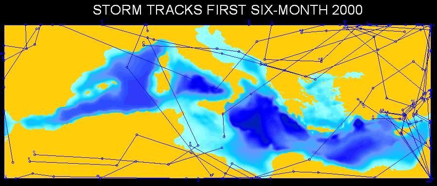
10 Computation and Plotting of Storm Tracks Storm Tracks identified by following low pressure centres on synoptic charts and plotting their trajectories on maps (Serreze, 1995) NASA automated cyclone detection and cyclone tracking algorithm The 3-hourly Sea Level Pressure (SLP) data 12-hourly SLP (POSEIDON weather forecasting system) Rules applied: Two successive SLP minima must be in a distance 1440 km (cyclone max speed = 120 km/hr) Storms must last at least 36 hours (three12-hr segments) Two segments on the same track must not define an angle < 85
11

12 Storm-track calculation
13 storm tracks direction & magnitude 2001 Average SLP during storm track Min SLP during storm track
14 storm tracks directions & magnitude ( )
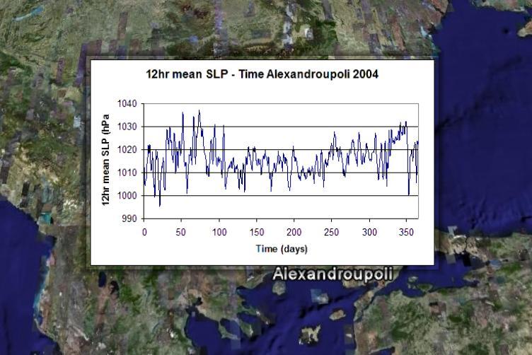
15 12hr max SLH (m) 12hr max SLH (m) 12hr mean SLP (hpa) 12hr mean SLP (hpa) Chios 2004 Alexandroupolis hr mean SLP - Time Chios hr mean SLP - Time Alexandroupoli Time (days) Time (days) hr max SLH - Time Chios Time (days) hr max SLH - Time Alexandroupoli Time (days)
16 12hr max SLH (m) 12hr max SLH (m) Chios hr max SLH - 12hr mean SLP Chios 2004 (r=-0.62) Alexandroupolis hr mean SLP (hpa) 12hr mean SLP - 12hr max SLH Alexandroupoli hr mean SLP (hpa)
17 SLP-SLH correlations for the period of Station Ancona (Italy) Antalya (Turkey) Alexandroupolis (Greece) Barcelona (Spain) Catania (Italy) Chios (Greece) Dubrovnik (Croatia) Genova (Italy) Lefkas (Greece) Naples (Italy) Otranto (Italy) Rovinj (Croatia) Split (Croatia) Trieste (Italy) Zadar (Croatia)

18 Storm surge model A 2-dimensional hydrodynamic model Grid resolution 1/10 o x 1/10 o Forcing: wind data, atmospheric pressure and wave data Boundary conditions: Tidal input imposed in the Gibraltar
19 Alexandroupolis In situ measurements and model results In situ measurements Model results Dubrovnik
 y(m) SLP(hPa) 0.8 0.6 0.4 0.2 0-0.2-0.4 03-02-03_PM 1168322 1721899 1002.")

20 Sea level Alteration February 5, 2003 Direction: W-E The coastal areas affected by this event are especially in the central Adriatic and the south Aegean 10 x(m) y(m) SLP(hPa) _PM _AM Model output _PM _AM _PM _AM days _PM _AM
21 max Sea Level Rises and % frequencies Coastal area Max Sea Level Rise Sea Level Rise ΔH>+0.30m Sea Level Rise ΔH>+0.60m Rovinj (HR) Dubrovnik (HR) Alexandroupoli (GR) Lefkas (GR) Chios (GR) Antalya II (TR) Split (HR) Trieste (IT) Catania (IT) Ancona (IT) Otranto (IT) Kavala (GR) Herakleio (GR) Thessaloniki (GR) Zadar (HR) *Venice (IT) *Albanian coasts *Adana (TR) *Alexandroupoli (GR) *Malliakos Gulf (GR) *Patras (GR) *Bari (IT)
22 max SLH (m) % Frequency of SLH>20cm max Sea Level Rises and % frequencies % Frequency of SLH>20cm in various areas of Eastern Mediterranean for years (model hindcasting) max SLH in various areas of Eastern Mediterranean years (model hindcasting) for Rovinj (HR) Dubrovnik (HR) Alexandroupoli (GR) Lefkas (GR) Chios (GR) Antalya II (TR) Split (HR) Trieste (IT) Catania (IT) Naples (IT) Ancona (IT) Otranto (IT) Kavala (GR) Herakleio (GR) Thessaloniki (GR) Zadar (HR) *Alexandria (EG) *Venice (IT) *Albanian coasts *Adana (TR) *Alexandroupoli (GR) *Malliakos Gulf (GR) *Patras (GR) *Banghazi (LY) *Bari (IT) *Tripolis (LY) 0 1,40 1,20 1,00 0,80 0,60 0,40 0,20 0,00 Rovinj (HR) Dubrovnik (HR) Alexandroupoli (GR) Lefkas (GR) Chios (GR) Antalya II (TR) Split (HR) Trieste (IT) Catania (IT) Naples (IT) Ancona (IT) Otranto (IT) Herakleio (GR) Thessaloniki (GR) Zadar (HR) Kavala (GR) *Alexandria (EG) *Venice (IT) *Albanian coasts *Adana (TR) *Alexandroupoli (GR) *Malliakos Gulf (GR) *Patras (GR) *Banghazi (LY) *Bari (IT) *Tripolis (LY)
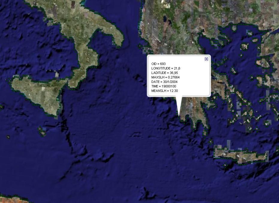

23 Google-earth maps & inundation data
24 Conclusions - Proposals Hindcasting storm surge events and detecting previous inundation cases can offer to stakeholders a better view of possible changes and corrections that need to be done in already developed risky coastal areas. The combination of atmospheric forecasting models with a storm surge hydrodynamic model can estimate the future sea level rise events and the inundation risk in the low elevation coastal areas. The couple forecasting models (atmospheric + wave + storm-surge) could be the main tool for a warning systems of coastal flooding. These system can improve authorities preparedness and help coastal human society to obtain proper measurements in cases of an extreme meteorological incidents. The couple forecasting models (atmospheric + wave+ storm-surge) could help for the adoption of the European Directive 2007/60/ΕC
25 European Directive 2007/60/ΕC (23/10/2007) On the assessment and management of flood risks flood means the temporary covering by water of land not normally covered by water. This shall include floods from rivers, mountain torrents, Mediterranean ephemeral water courses, and floods from the sea in coastal areas, Member States will by 2011 undertake a preliminary flood risk assessment of their river basins and associated coastal zones, to identify areas where potential significant flood risk exists. Where real risks of flood damage exist, they must by 2013 develop flood hazard maps and flood risk maps for such areas. By 2015 flood risk management plans must be drawn up for these zones.
26 Thank you for your attention
A storm surge model implementation and identification of coastal areas in risk of inundation, in the Mediterranean Sea.
 International Congress on Environmental Modelling and Software Brigham Young University BYU ScholarsArchive 4th International Congress on Environmental Modelling and Software - Barcelona, Catalonia, Spain
Sea level modelling and forecasting in the Northern Adriatic
 Sea level modelling and forecasting in the Northern Adriatic F. Raicich/*) S. Piacsek/*) R. Purini,^ L. Perini WCNR, Istituto Sperimentale Talassografico, viale R. Gessi 2, 1-34123 Trieste, Italy EMail:
Coupling of Wave and Hydrodynamic Models for Predicting Coastal Inundation: A case study in Jakarta and Semarang
 Coupling of Wave and Hydrodynamic Models for Predicting Coastal Inundation: A case study in Jakarta and Semarang http://peta-maritim.bmkg.go.id/cifdp/maps Nelly Florida Riama,Andri Ramdhani, Andi Eka Sakya,,
NOAA s National Weather Service Philadelphia/Mt. Holly NJ
 Next Briefing Package: Thursday, October 1, 2015 no later than 300 PM Hazards and Impacts: Overview: A dangerous weather pattern is developing for our region. Threats include very heavy rainfall, inland
NOAA s National Weather Service Philadelphia/Mt. Holly NJ
 Next Briefing Package: Friday, October 2, 2015 no later than 300 PM Hazards and Impacts: Overview: A dangerous weather pattern still threatens our region. Threats include very heavy rainfall, inland river
PS4a: Real-time modelling platforms during SOP/EOP
 PS4a: Real-time modelling platforms during SOP/EOP Mistral Tramontane Bora Etesian Major sites of dense water formation Major sites of deep water formation influence of coastal waters Chairs: G. Boni,
Climate Change Impacts and Adaptation for Coastal Transport Infrastructure in Caribbean SIDS
 UNCTAD National Workshop Saint Lucia 24 26 May 2017, Rodney Bay, Saint Lucia Climate Change Impacts and Adaptation for Coastal Transport Infrastructure in Caribbean SIDS LISCoAsT Large Scale Integrated
Modelling coastal flood risk in the data poor Bay of Bengal region
 Modelling coastal flood risk in the data poor Bay of Bengal region Matt Lewis*, Kevin Horsburgh (NOC), Paul Bates (Bristol) *m.j.lewis@bangor.ac.uk Funded by the EPSRC Flood Risk Management Research Consortium
Frank Revitte National Weather Service. Weather Forecast Office New Orleans/Baton Rouge
 Frank Revitte National Weather Service Weather Forecast Office New Orleans/Baton Rouge Above normal activity 17 Total Named Storms 7 Tropical Storms 4 Hurricanes 6 Major Hurricanes Not the most active,
Assessment of sea surface temperatures provided in the coupling files from ARPEGE and IFS
 Assessment of sea surface temperatures provided in the coupling files from ARPEGE and IFS Martina Tudor, Stjepan Ivatek-Šahdan, Antonio Stanešić Croatian Meteorological and Hydrological Service Abstract
2) What general circulation wind belt is the place of origin for hurricanes? A) westerlies B) trade winds C) doldrums D) horse latitudes
 What general circulation wind belt is the place of origin for hurricanes? A) westerlies B) trade winds C) doldrums D) horse latitudes") Meteo 1010 Homework 6 1) What is the difference between a typhoon and a hurricane? A) A hurricane is a true tropical cyclone, but a typhoon is not. B) A hurricane is stronger than a typhoon. C) They represent
Meteo 1010 Homework 6 1) What is the difference between a typhoon and a hurricane? A) A hurricane is a true tropical cyclone, but a typhoon is not. B) A hurricane is stronger than a typhoon. C) They represent
Integrating Hydrologic and Storm Surge Models for Improved Flood Warning
 Integ Hydrologic and Storm Surge Models for Improved Flood Warning Leahy, C.P, Entel, M, Sooriyakumaran, S, and Warren, G Flood Warning Program Office, Bureau of Meteorology, Docklands, Victoria National
EFFECTIVE TROPICAL CYCLONE WARNING IN BANGLADESH
 Country Report of Bangladesh On EFFECTIVE TROPICAL CYCLONE WARNING IN BANGLADESH Presented At JMA/WMO WORKSHOP ON EFFECTIVE TROPICAL CYCLONE WARNING IN SOUTHEAST ASIA Tokyo, Japan,11-14 March 2014 By Sayeed
Storm surge forecast activities. in the Northern Adriatic Sea and in the lagoons
 Storm surge network forum ISMAR Venice 18-20 November 2013 Storm surge forecast activities in the Northern Adriatic Sea and in the lagoons Marco Cordella ISPRA Venice Lagoon Service Castello 4665, Venice
Tropical Cyclones Modelling For Natural Disaster Risk Management
 Tropical Cyclones Modelling For Natural Disaster Risk Management Juan Savioli a, M. Britton b, S. Szylkarski a and Claus Pederson a a DHI Water and Environment, 2 Elliott Street, Suite 1a, QLD 4217 Surfers
EO Information Services in support of West Africa Coastal vulnerability Service 2 : Sea Level Height & currents. Vinca Rosmorduc, CLS
 EO Information Services in support of West Africa Coastal vulnerability Service 2 : Sea Level Height & currents Vinca Rosmorduc, CLS World Bank HQ, Washington DC Date : 23 February 2012 West Africa coastal
Add NOAA nowcoast Layers to Maps
 WebEOC Maps Add-on Quick Reference Guide Add NOAA nowcoast Layers to Maps Overview With Maps Add-on, you can configure an unlimited number of map layers. These layers allow you to control the data you
Intergovernmental Oceanographic Commission of UNESCO
 Intergovernmental Oceanographic Commission of UNESCO Thorkild Aarup - Stefano Belfiore IOC Secretariat Regional Workshop on Disaster Risk Reduction and Climate Change Challenges and Future Actions Cairo,
Keywords: lightning climatology; lightning flashes; Macedonia Greece.
 International Scientific Conference GEOBALCANICA 2018 A 10-YEAR CLIMATOLOGY OF LIGHTNING FOR MACEDONIA, GREECE Paraskevi Roupa 1 Theodore Karacostas 2 1 Hellenic National Meteorological Service, Greece
Environmental Science
 ISSN : 0974-7451 Volume 9 Issue 7 Sea level rise along the Mediterranean coast of Egypt A.Parker RMIT University, Bundoora, VIC 3083, (AUSTRALIA) E-mail : albert.parker@rmit.edu.au ESAIJ, 9(7), 2014 [231-236]
Preliminary Vulnerability Assessment of Coastal Flooding Threats - Taylor County, Florida
 Preliminary Vulnerability Assessment of Coastal Flooding Threats - Taylor County, Florida North Central Florida Regional Planning Council Northeast Florida Regional Council April 28, 2016 BACKGROUND This
Storm surge forecasting and other Met Office ocean modelling
 Storm surge forecasting and other Met Office ocean modelling EMODnet stakeholder meeting Clare O Neill + many others Outline Ocean modelling at the Met Office Storm surge forecasting Current operational
Experimental Probabilistic Hurricane Inundation Surge Height (PHISH) Guidance
 Guidance") Experimental Probabilistic Hurricane Inundation Surge Height (PHISH) Guidance DRBC Flood Advisory Committee John Kuhn - NWS/OCWWS Anne Myckow (NWS/MDL), Arthur Taylor (NWS/MDL) SLOSH Sea, Lake and Overland
Experimental Probabilistic Hurricane Inundation Surge Height (PHISH) Guidance DRBC Flood Advisory Committee John Kuhn - NWS/OCWWS Anne Myckow (NWS/MDL), Arthur Taylor (NWS/MDL) SLOSH Sea, Lake and Overland
Improving global coastal inundation forecasting WMO Panel, UR2014, London, 2 July 2014
 Improving global coastal inundation forecasting WMO Panel, UR2014, London, 2 July 2014 Cyclone Sidr, November 2007 Hurricane Katrina, 2005 Prof. Kevin Horsburgh Head of marine physics, UK National Oceanography
Remote Sensing and GIS Contribution to. Tsunami Risk Sites Detection. of Coastal Areas in the Mediterranean
 The Third International Conference on Early Warning (EWC III), 26.-29.March 2006 in Bonn Remote Sensing and GIS Contribution to Tsunami Risk Sites Detection of Coastal Areas in the Mediterranean BARBARA
Semi-enclosed seas. Estuaries are only a particular type of semi-enclosed seas which are influenced by tides and rivers
 Semi-enclosed seas Estuaries are only a particular type of semi-enclosed seas which are influenced by tides and rivers Other semi-enclosed seas vary from each other, mostly by topography: Separated from
1.2 DEVELOPMENT OF THE NWS PROBABILISTIC EXTRA-TROPICAL STORM SURGE MODEL AND POST PROCESSING METHODOLOGY
 1.2 DEVELOPMENT OF THE NWS PROBABILISTIC EXTRA-TROPICAL STORM SURGE MODEL AND POST PROCESSING METHODOLOGY Huiqing Liu 1 and Arthur Taylor 2* 1. Ace Info Solutions, Reston, VA 2. NOAA / NWS / Science and
Hurricane Matthew. National Weather Service Wilmington NC. Steven Pfaff, WCM.
 Hurricane Matthew Threat Assessment for northeast South Carolina & southeast North Carolina National Weather Service Wilmington NC 730 AM EDT Tuesday October 4, 2016 Steven Pfaff, WCM Steven.Pfaff@noaa.gov
International Conference Analysis and Management of Changing Risks for Natural Hazards November 2014 l Padua, Italy
 Abstract code: AO6 Hindcast of extreme hydro-meteorological events along the Bulgarian Black Sea coast Anna Kortcheva, Vasko Galabov, Marieta Dimitrova, Andrey Bogatchev National Institute of Meteorology
CHAPTER 13 WEATHER ANALYSIS AND FORECASTING MULTIPLE CHOICE QUESTIONS
 CHAPTER 13 WEATHER ANALYSIS AND FORECASTING MULTIPLE CHOICE QUESTIONS 1. The atmosphere is a continuous fluid that envelops the globe, so that weather observation, analysis, and forecasting require international
Uncertainty in the SWAT Model Simulations due to Different Spatial Resolution of Gridded Precipitation Data
 Uncertainty in the SWAT Model Simulations due to Different Spatial Resolution of Gridded Precipitation Data Vamsi Krishna Vema 1, Jobin Thomas 2, Jayaprathiga Mahalingam 1, P. Athira 4, Cicily Kurian 1,
Storms. 3. Storm types 4. Coastal Sectors 5. Sorm Location and Seasonality 6. Storm Severity 7. Storm Frequency and grouping 8. The design storm event
 1. Introduction Storms 2. The Impact of Storms on the coast 3. Storm types 4. Coastal Sectors 5. Sorm Location and Seasonality 6. Storm Severity 7. Storm Frequency and grouping 8. The design storm event
TOWNSVILLE STORM SURGE HYPOTHETICAL: TECHNICAL SPECIFICATIONS
 TOWNSVILLE STORM SURGE HYPOTHETICAL: TECHNICAL SPECIFICATIONS Stuart Mead, Mahesh Prakash and Fletcher Woolard CSIRO Mathematics, Informatics and Statistics, Private Bag 33, Clayton South, VIC 3168, Australia
INTEGRATED COASTAL MONITORING OF ENVIRONMENTAL PROBLEMS IN SEA REGION AND THE WAYS OF THEIR SOLUTION
 INTEGRATED COASTAL MONITORING OF ENVIRONMENTAL PROBLEMS IN SEA REGION AND THE WAYS OF THEIR SOLUTION Panagiotis Symeonidis 1, Ioannis Boskidis 1, Symeon Taskaris 1, Georgios K. Sylaios 2, Nikolaos Kokkos
Regional Flash Flood Guidance and Early Warning System
 WMO Training for Trainers Workshop on Integrated approach to flash flood and flood risk management 24-28 October 2010 Kathmandu, Nepal Regional Flash Flood Guidance and Early Warning System Dr. W. E. Grabs
Physical Dynamics of the Coastal Zone in the Mediterranean on Annual to Decadal Scales
 Physical Dynamics of the Coastal Zone in the Mediterranean on Annual to Decadal Scales Hans-Peter Plag Nevada Bureau of Mines and Geology and Seismological Laboratory University of Nevada, Reno, Nevada,
Mediterranean Sea and Territorial Development, Opportunities and Risks
 EESC Hearing Towards an EU Macro-Regional Strategy for the Mediterranean Mediterranean Sea and Territorial Development, Opportunities and Risks Michaela Gensheimer Structure of Intervention Part I: What
Nerushev A.F., Barkhatov A.E. Research and Production Association "Typhoon" 4 Pobedy Street, , Obninsk, Kaluga Region, Russia.
 DETERMINATION OF ATMOSPHERIC CHARACTERISTICS IN THE ZONE OF ACTION OF EXTRA-TROPICAL CYCLONE XYNTHIA (FEBRUARY 2010) INFERRED FROM SATELLITE MEASUREMENT DATA Nerushev A.F., Barkhatov A.E. Research and
Ms. Latoya Regis. Meteorologist Hydrometeorological Service, Guyana
 Ms. Latoya Regis Meteorologist Hydrometeorological Service, Guyana Background Ninety percent (90%) of Guyana s population resides along the (Atlantic) Coast, which is below mean sea level and accounts
Tropical Update. 5 AM EDT Tuesday, September 12, 2017 Post-Tropical Cyclone Irma, Hurricane Jose, & Tropical Wave (10%)
") Tropical Update 5 AM EDT Tuesday, September 12, 2017 Post-Tropical Cyclone Irma, Hurricane Jose, & Tropical Wave (10%) This update is intended for government and emergency response officials, and is provided
Tropical Update 5 AM EDT Tuesday, September 12, 2017 Post-Tropical Cyclone Irma, Hurricane Jose, & Tropical Wave (10%) This update is intended for government and emergency response officials, and is provided
JCOMM-CHy Coastal Inundation Forecasting Demonstration Project (CIFDP)
") WMO World Meteorological Organization Working together in weather, climate and water JCOMM-CHy Coastal Inundation Forecasting Demonstration Project (CIFDP) Coastal Flooding & Vulnerable Populations Coastal
WMO World Meteorological Organization Working together in weather, climate and water JCOMM-CHy Coastal Inundation Forecasting Demonstration Project (CIFDP) Coastal Flooding & Vulnerable Populations Coastal
EMERGENCY PLANNING IN NORTHERN ALGERIA BASED ON REMOTE SENSING DATA IN RESPECT TO TSUNAMI HAZARD PREPAREDNESS
 EMERGENCY PLANNING IN NORTHERN ALGERIA BASED ON REMOTE SENSING DATA IN RESPECT TO TSUNAMI HAZARD PREPAREDNESS Barbara Theilen-Willige Technical University of Berlin, Institute of Applied Geosciences Department
Severe Weather Potential for Southeast Texas
 Severe Weather Potential for Southeast Texas Dan Reilly, Kent Prochazka, Scott Overpeck National Weather Service Houston/Galveston 10 am Synopsis Storm to likely bring severe weather to Southeast Texas
DEVELOPMENT OF A FORECAST EARLY WARNING SYSTEM ethekwini Municipality, Durban, RSA. Clint Chrystal, Natasha Ramdass, Mlondi Hlongwae
 DEVELOPMENT OF A FORECAST EARLY WARNING SYSTEM ethekwini Municipality, Durban, RSA Clint Chrystal, Natasha Ramdass, Mlondi Hlongwae LOCATION DETAILS AND BOUNDARIES ethekwini Municipal Area = 2297 km 2
Altimetry for Coastal Applications. Paul M. DiGiacomo and Amanda Bittinger NOAA CoastWatchatch Program 5 February 2008
 Altimetry for Coastal Applications Paul M. DiGiacomo and Amanda Bittinger NOAA CoastWatchatch Program 5 February 2008 IGOS COASTAL THEME REPORT Published January 2006, IOC http://www.igospartners.org/d
Climate Change Impacts and Adaptation for Coastal Transport Infrastructure in Caribbean SIDS
 UNCTAD National Workshop Jamaica 30 May 1 June 2017, Kingston, Jamaica Climate Change Impacts and Adaptation for Coastal Transport Infrastructure in Caribbean SIDS LISCoAsT Large Scale Integrated Sealevel
Heavy Rain/Flooding September 8-10 Associated with Tropical Storm Etau
 Heavy Rain/Flooding September 8-10 Associated with Tropical Storm Etau Wx Files Vol.32 September 24, 2015 Tropical Storm Etau made landfall over the Chita Peninsula in Aichi just after 10:00 AM on September
An Application of Hydrometeorological Information
 An Application of Hydrometeorological Information Weather-proof Café: Hydro-meteorological information in managing weather risks 17 19 November 2012 National Taiwan University, Chinese Taipei Nikos Viktor
Weather forecasts and warnings: Support for Impact based decision making
 Weather forecasts and warnings: Support for Impact based decision making Gerry Murphy, Met Éireann www.met.ie An Era of Change Climate and weather is changing Societal vulnerability is increasing The nature
Overview of the Tropical Cyclone Guidance Project
 Overview of the Tropical Cyclone Guidance Project Dr. Jonathan L. Vigh With thanks to Mahsa Mirzargar (Univ. of Miami) Shanghai Typhoon Institute 09 July 2018 NCAR is sponsored by the National Science
The UK Flood Forecasting Centre
 Storm Surge Networking Forum, Venice: Tuesday 19 th November 2013 The UK Flood Forecasting Centre Dave Cox - Senior Hydrometeorologist FFC Exeter, England. In My talk today I will cover: Ü Overview of
Flood Forecasting in Bangladesh
 Flood Forecasting in Bangladesh Types of Flood ing Flood ing can be divided into two categories: Flood ing in the rivers caused by upstream rise of river stage as well as rainfall in the basin. Overland
Tropical Update. 11 AM EDT Tuesday, October 9, 2018 Hurricane Michael, Tropical Storm Leslie, Tropical Storm Nadine
 Tropical Update 11 AM EDT Tuesday, October 9, 2018 Hurricane Michael, Tropical Storm Leslie, Tropical Storm Nadine This update is intended for government and emergency response officials, and is provided
TOSCA RESULTS OVERVIEW
 TOSCA RESULTS OVERVIEW Almost 3 years after the project started, TOSCA has proved capable of improving oil spill tracking systems. TOSCA has brought updated knowledge on surface currents and noticeable
Hindcast Arabian Gulf
 Hindcast Arabian Gulf Image of isobars of atmospheric pressure and hindcast wind- and wave field over the Arabian Gulf during a storm in January 1993. Detailed wave studies are supported by nesting of
Seasonal Forecast for the area of the east Mediterranean, Products and Perspectives
 Seasonal Forecast for the area of the east Mediterranean, Products and Perspectives Dr Kleanthis Nicolaides Senior Meteorological Officer Department of Meteorology The need for weather forecasts from where
Assessing Storm Tide Hazard for the North-West Coast of Australia using an Integrated High-Resolution Model System
 Assessing Storm Tide Hazard for the North-West Coast of Australia using an Integrated High-Resolution Model System J. Churchill, D. Taylor, J. Burston, J. Dent September 14, 2017, Presenter Jim Churchill
Simulation of storm surge and overland flows using geographical information system applications
 Coastal Processes 97 Simulation of storm surge and overland flows using geographical information system applications S. Aliabadi, M. Akbar & R. Patel Northrop Grumman Center for High Performance Computing
FIG Working Week May, Bulgaria From the wisdom of the ages to the challanges of modern world
 FIG Working Week 17-21 May, Bulgaria From the wisdom of the ages to the challanges of modern world COASTAL RISK ANALYSIS OF THE BLACK SEA UNDER THE SEA LEVEL RISE N e v i n B e t u l A V S A R, S e n o
Severe Freezing Rain in Slovenia
 Severe Freezing Rain in Slovenia Janez Markosek, Environmental Agency, Slovenia Introduction At the end of January and at the beginning of February 2014, severe and long-lasting freezing rain affected
Synoptic and mesoscale analysis of waterspouts in the Adriatic ( preliminary climatology)
") Synoptic and mesoscale analysis of waterspouts in the Adriatic (2001-2011 preliminary climatology) Josipa Kuzmić 1, Tanja Renko 1, Nataša Strelec Mahović 1 1 Meteorological and Hydrological Service of
Synoptic and mesoscale analysis of waterspouts in the Adriatic (2001-2011 preliminary climatology) Josipa Kuzmić 1, Tanja Renko 1, Nataša Strelec Mahović 1 1 Meteorological and Hydrological Service of
Hydrological forecasting and decision making in Australia
 Hydrological forecasting and decision making in Australia Justin Robinson, Jeff Perkins and Bruce Quig Bureau of Meteorology, Australia The Bureau's Hydrological Forecasting Services Seasonal Forecasts
MODELLING CATASTROPHIC COASTAL FLOOD RISKS AROUND THE WORLD
 MODELLING CATASTROPHIC COASTAL FLOOD RISKS AROUND THE WORLD Nicola Howe Christopher Thomas Copyright 2016 Risk Management Solutions, Inc. All Rights Reserved. June 27, 2016 1 OUTLINE MOTIVATION What we
Caribbean Early Warning System Workshop
 Caribbean Early Warning System Workshop Hamonization in Existing EWS April 14-16, 2016 Presenter: Shawn Boyce Caribbean Institute for Meteorology and Hydrology Husbands, St. James Barbados Background Between
11/19/14. Chapter 11: Hurricanes. The Atmosphere: An Introduction to Meteorology, 12 th. Lutgens Tarbuck
 Chapter 11: Hurricanes The Atmosphere: An Introduction to Meteorology, 12 th Lutgens Tarbuck Lectures by: Heather Gallacher, Cleveland State University! Hurricanes: " Hurricanes are intense centers of
Coastal Emergency Risks Assessment - CERA Real-Time Storm Surge and Wave Visualization Tool
 Coastal Emergency Risks Assessment - CERA Real-Time Storm Surge and Wave Visualization Tool Introduction This document provides guidance for using the Coastal Emergency Risks Assessment (CERA) visualization
Homework 8: Hurricane Damage (adapted from Pipkin et al.)
") 1 Homework 8: Hurricane Damage (adapted from Pipkin et al.) Tropical cyclones have a significant impact on coastal areas of the world. In the Atlantic and Eastern Pacific Oceans they are called hurricanes
1 Homework 8: Hurricane Damage (adapted from Pipkin et al.) Tropical cyclones have a significant impact on coastal areas of the world. In the Atlantic and Eastern Pacific Oceans they are called hurricanes
COASTAL DATA APPLICATION
 2015 Coastal GeoTools Proactive By Design. Our Company Commitment COASTAL DATA APPLICATION Projecting Future Coastal Flood Risk for Massachusetts Bay Bin Wang, Tianyi Liu, Daniel Stapleton & Michael Mobile
Evaluation of Flash flood Events Using NWP Model and Remotely Sensed Rainfall Estimates
 Evaluation of Flash flood Events Using NWP Model and Remotely Sensed Rainfall Estimates Dr. Ismail Yucel METU Civil Engineering Department and Fatih Keskin State Hydraulic Works HydroPredict 2010 Prague
Coastal Inundation Forecasting and Community Response in Bangladesh
 WMO Coastal Inundation Forecasting and Community Response in Bangladesh Bapon (SHM) Fakhruddin Nadao Kohno 12 November 2015 System Design for Coastal Inundation Forecasting CIFDP-PSG-5, 14-16 May 2014,
Impact of sea surface temperature on COSMO forecasts of a Medicane over the western Mediterranean Sea
 Impact of sea surface temperature on COSMO forecasts of a Medicane over the western Mediterranean Sea V. Romaniello (1), P. Oddo (1), M. Tonani (1), L. Torrisi (2) and N. Pinardi (3) (1) National Institute
Climate variability and the expected. Croatia
 Climate variability and the expected effects of climate change scenario in Croatia Krešo Pandžić Meteorological and Hydrological Service Croatia National roundtable Adaptation to climate change, Zagreb,
Outline. Remote Sensing, GIS and DEM Applications for Flood Monitoring. Introduction. Satellites and their Sensors used for Flood Mapping
 Outline Remote Sensing, GIS and DEM Applications for Flood Monitoring Prof. D. Nagesh Kumar Chairman, Centre for Earth Sciences Professor, Dept. of Civil Engg. Indian Institute of Science Bangalore 560
Severe storms over the Mediterranean Sea: A satellite and model analysis
 National Research Council of Italy Severe storms over the Mediterranean Sea: A satellite and model analysis V. Levizzani, S. Laviola, A. Malvaldi, M. M. Miglietta, and E. Cattani 6 th International Precipitation
CASE STUDY: Tropical Cyclone Monica, April 2006
 CASE STUDY: Tropical Cyclone Monica, April 2006 By Mr Jeff Callaghan Retired Senior Severe Weather Forecaster, Bureau of Meteorology, Brisbane The track of tropical cyclone Monica (Figure 1) took it from
HURRICANES AND TORNADOES
 HURRICANES AND TORNADOES The most severe weather systems are hurricanes and tornadoes. They occur in extremely low pressure systems, or cyclones, when the air spirals rapidly into the center of a low.
Meteorological similarities and differences of the great European floods
 Meteorological similarities and differences of the great European floods Nataša Strelec Mahović DHMZ Meteorological and Hydrological Service, Croatia Europe floods 1998-2008 Areas most frequently affected
New developments in data assimilation in MIKE 21/3 FM Assimilation of along-track altimetry data with correlated measurement errors
 New developments in data assimilation in MIKE 21/3 FM Assimilation of along-track altimetry data with correlated measurement errors EnKF Workshop 2016-06-20 Jesper Sandvig Mariegaard Henrik Andersson DHI
Earth Observation & forecasting Storm Surges in the North Western Pacific. Mr. Nadao Kohno Japan Meteorological Agency
 Earth Observation & forecasting Storm Surges in the North Western Pacific Mr. Nadao Kohno Japan Meteorological Agency Lesson Outline Introduction JMA s responsibility and work as a RSMC, Tokyo Typhoon
An Overview of Operations at the West Gulf River Forecast Center Gregory Waller Service Coordination Hydrologist NWS - West Gulf River Forecast Center
 National Weather Service West Gulf River Forecast Center An Overview of Operations at the West Gulf River Forecast Center Gregory Waller Service Coordination Hydrologist NWS - West Gulf River Forecast
Yannis N. Krestenitis. Professor of Coastal Engineering & Oceanography
 1 Yannis N. Krestenitis Position: Professor of Coastal Engineering & Oceanography Organization: Aristotle University of Thessaloniki School of Civil Engineering Engineering Department of Hydraulics and
2014/2/25. Earth Observation & forecasting Storm Surges in the North Western Pacific. Lesson Outline. RSMC Tokyo Typhoon Center.
 Earth Observation & forecasting Storm Surges in the North Western Pacific Mr. Nadao Kohno Japan Meteorological Agency Lesson Outline Introduction JMA s responsibility and work as a RSMC, Tokyo Typhoon
Tropical Cyclone Oswald Coastal Monitoring
 Tropical Cyclone Oswald Coastal Monitoring Kieran Harper and John Maher Coastal Impacts Unit, Queensland Department of Science, Information Technology, Innovation and the Arts (DSITIA). 27 Quinlan St Deagon,
networks from ISPRA GABRIELE NARDONE, MAURO BENCIVENGA, GIOVANNI ARENA
 The Italian observational networks from ISPRA retemareografica@isprambiente.itit reteondametrica@isprambiente.it GABRIELE NARDONE, MAURO BENCIVENGA, GIOVANNI ARENA ISPRA - RMN Italian Tide Gauge Network
GC Briefing. Weather Sentinel Tropical Storm Michael. Status at 8 AM EDT (12 UTC) Today (NHC) Discussion. October 11, 2018
 Today (NHC) Discussion. October 11, 2018") GC Briefing Weather Sentinel Tropical Storm Michael October 11, 2018 After making landfall as a high-end category-4 hurricane on the Florida Panhandle, Michael weakened to tropical storm status early this
GC Briefing Weather Sentinel Tropical Storm Michael October 11, 2018 After making landfall as a high-end category-4 hurricane on the Florida Panhandle, Michael weakened to tropical storm status early this
Impact of Sea Level Rise on Future Storm-induced Coastal Inundation
 Impact of Sea Level Rise on Future Storm-induced Coastal Inundation Changsheng Chen School for Marine Science and Technology, University of Massachusetts-Dartmouth Email: c1chen@umassd.edu 04/14/2015 Outline
HURRICANE IRENE. CONFERENCE CALL BRIEFING SLIDES Saturday August 27, :30 AM
 HURRICANE IRENE CONFERENCE CALL BRIEFING SLIDES Saturday August 27, 2011 8:30 AM NHC TRACK AND CONE HURRICANE IRENE WATCHES/WARNINGS Hurricane Warning along south coast including all of Cape Cod and Islands
The Devastating Western European Winter Storm February 2010 By Richard H. Grumm National Weather Service
 The Devastating Western European Winter Storm 27-28 February 2010 By Richard H. Grumm National Weather Service 1. INTRODUCTION A strong late winter storm, called Xynthia 1, raced across Western Europe
Saiful Islam Anisul Haque
 Workshop on Disaster Prevention/Mitigation Measures against Floods and Storm Surges in Bangladesh on 17-21 November, 2012, in Kyoto University, Japan Component 2: Flood disaster risk assessment and mitigation
A Cloud-Based Flood Warning System For Forecasting Impacts to Transportation Infrastructure Systems
 A Cloud-Based Flood Warning System For Forecasting Impacts to Transportation Infrastructure Systems Jon Goodall Associate Professor, Civil and Environmental Engineering Associate Director, Link Lab April
DELINEATION OF COASTLINE AND MARINE SDI IN CROATIA
 CO-090 DELINEATION OF COASTLINE AND MARINE SDI IN CROATIA LEDER N.(1), DUPLANČIĆ LEDER T.(2) (1) Hydrographic Institute of the Republic of Croatia, SPLIT, CROATIA ; (2) Faculty of Civil Engineering and
Emerging Needs, Challenges and Response Strategy
 Emerging Needs, Challenges and Response Strategy Development of Integrated Observing Systems in China JIAO Meiyan Deputy Administrator China Meteorological Administration September 2011 Geneva Outline
P2.57 Cyclone Yasi Storm Surge in Australia Implications for Catastrophe Modeling
 P2.57 Cyclone Yasi Storm Surge in Australia Implications for Catastrophe Modeling Kevin A. Hill*, Peter Sousounis, and Jason Butke AIR Worldwide Corporation, Boston, Massachusetts 1. INTRODUCTION Storm
Chapter 12: Meteorology
 Chapter 12: Meteorology Section 1: The Causes of Weather 1. Compare and contrast weather and climate. 2. Analyze how imbalances in the heating of Earth s surface create weather. 3. Describe how and where
FLOODS IN SOUTHWESTERN SRI LANKA IN MAY 2017
 FLOODS IN SOUTHWESTERN SRI LANKA IN MAY 2017 Foundation for Environment, Climate and Technology C/o Mahaweli Authority of Sri Lanka, Digana Village, Rajawella, Kandy, KY 20180, Sri Lanka Citation Lokuhetti,
Dr. S.SURIYA. Assistant professor. Department of Civil Engineering. B. S. Abdur Rahman University. Chennai
 Hydrograph simulation for a rural watershed using SCS curve number and Geographic Information System Dr. S.SURIYA Assistant professor Department of Civil Engineering B. S. Abdur Rahman University Chennai
Earth Observation in coastal zone MetOcean design criteria
 ESA Oil & Gas Workshop 2010 Earth Observation in coastal zone MetOcean design criteria Cees de Valk BMT ARGOSS Wind, wave and current design criteria geophysical process uncertainty modelling assumptions
Estimation of extreme sea levels from altimetry and tide gauges at the coast
 Estimation of extreme sea levels from altimetry and tide gauges at the coast Xiaoli Deng (1), Ole B. Andersen (2), Yongcun Cheng (2), Mark G. Stewart (1) and Zahra Gharineiat (1) (1) School of Engineering,
Challenges in providing effective flood forecasts and warnings
 Challenges in providing effective flood forecasts and warnings National Centre for Flood Research Inaugural Symposium Justin Robinson Bureau of Meteorology October 2018 Zero Lives Lost A key responsibility