CHRIS HYPERSPECTRAL MISSION FIVE YEARS SINCE LAUNCH
|
|
|
- Magnus Ross
- 5 years ago
- Views:
Transcription

1 CHRIS HYPERSPECTRAL MISSION FIVE YEARS SINCE LAUNCH Paul Stephens Dr Mike Cutter Fordate Island, Indonesia


2 Mission Overview Instrument Overview Observation Programme Applications Snapshots Future Plans Contents Dubai 23rd Sept 2006 San Salvador, West Indies 22 nd Sept 2005

3 Mission Overview CHRIS Mission Proba-1: ESA smallsat technology platform (98 kg) Principal payload: CHRIS hyper-spectral imager Mission Objectives To assess Earth observation science from a small platform. To perform a range of science investigations. Special Features Highly agile small platform (roll, pitch & yaw) Multi-view angle observations of each target Use of forward motion compensation (x5) Utilisation Active User group 4 th CHRIS Workshop held in Frascati, Italy


4 Mission Overview - Launch Launch: 22 October 2001 PSLV Indian Launcher from Sriharikota island, India. Orbit: SSO 10:30am Altitude: 550 and 670 km. Inclination: 97.9 deg.

5 Mission Overview multiple angles Nominal view angles: +/- 55, +/- 36, 0

6 CHRIS Instrument Mass: 14kg Power: 8W Volume: 790x260x200mm CHRIS Data cube
7 Basic System Parameters Image area 13 km perigee Spatial sampling interval 17 perigee Spectral range (nominal) 400nm to 1050nm Spectral resolution 11nm Gain stage 4 levels (albedo 0.5,1,2,4 levels) Digitisation 12 bits Signal-to-noise ratio 200 (@ 0.2 albedo, 17m, 10nm) Programmable spectral & spatial dimensions
8 Programmed modes CHRIS Imaging Modes Mode No. of bands GSD (m) Swath Width Applications Full Aerosols Full Water Full Land Full Chlorophyll Half Land Mode 2 Bands 1 For example Mode 2 bands: Wavelength (nm)

9 2007 Observational Programme Venice, Italy, 20 Nov 2004
 cloud prediction Total images: Science 8540, Public relations 2298, Disaster Charter:")
10 CHRIS Science Sites in 2007 Science sites: 206 in 39 countries PIs: 87 Total 3 sets of 5 images per day ( 400 images/month) cloud prediction Total images: Science 8540, Public relations 2298, Disaster Charter: 510

11 Applications Snapshots La Rochelle Bromo Volcano, East Java 19 June 2004

12 Temporal & Angular Canopy Reflectance CHRIS reflectances from maize 17/08/2005 Swiss Midlands Temporal variation 22/09/2005 Multi-angular variation 20/06/ /08/ /06/ /05/ /05/2005 Source: Mathias Kneubühler et al, RSL, Univ. Zürich, Switzerland
")


13 Chlorophyll (Nitrogen) Detection in Uzbekistan Cotton Courtesy of G. Ruecker, German Aerospace Center (DLR),


14 Classification results in Canada Nadir Only Classification Error 19.1% Five Angles Classification Error 8.2% David Goodenough & Andrew Dyk, Natural Resources Canada, Canada


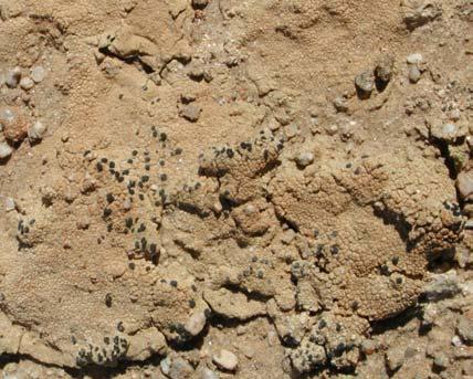
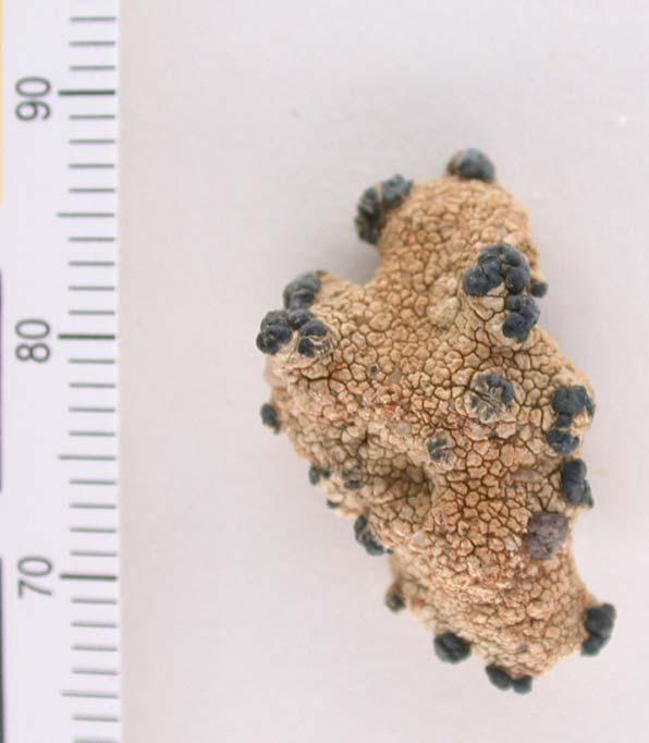

15 Lichen Cover in Central Namib Desert Fruticose Lichen Teloschistes capensis Important to ecology of region Foliose Lichen Xanthoparmelia spp. Crustose Lichen Lecidella crystallina Courtesy of Bettina Weber, University of Kaiserlautern Germany
16 Cover & biomass estimates of biological soil crusts 09/ /2003 Erosion Fruticose Fruticose/Foliose Foliose Foliose/Crustose Crustose Crustose Sparse Courtesy of Bettina Weber, University of Kaiserlautern, Germany Fruticose Fruticose/Foliose Foliose Foliose/Crustose Crustose Crustose Sparse


17 Coastal Investigation Ostend, Belgium 5 August 2003 Retrieval of Chlorophyll and Suspended Particulate Matter Courtesy of Kevin Ruddick et al, MUMM, Belgium (also University of Leuven, Belgium)


 Turbidity")


18 Inland Water Quality Assessment Aracena Dam, Spain Chlorophyll-a Total suspended solids (TSS) Turbidity Coloured dissolved organic matter (CDOM) Source: A. Polvorinos, University of Saville,


 AOD 13 km Courtesy of Will")
19 Aerosol Retrieval CHRIS image of Agoufou, West Africa acquired on 26th July 2006 Analysis of 5 pre-processed CHRIS images will be undertaken of data acquired over established AERONET sites Expect to get detailed information on aerosol properties (including size, and resulting optical properties) AOD 13 km Courtesy of Will Gray, Swansea University, UK


20 Bathymetric Mapping Courtesy of Ray Merton, University of New South Wales, Australia


21 Bathymetric mapping in turbid waters Courtesy of Ray Merton, University of New South Wales, Australia


")
22 Disaster management - Floods Since end 2003: Image provider for International Charter 7 Dec Arles (France) Floodings

23 Data Access Mangari, Cook Islands, 17 July 2005

24

25 ESA EO Data: EOLI Web-catalogue

26
27 Future Plans Continue CHRIS Programme through 2007 Development of an image processing toolbox: Noise reduction tool ( fixed pattern noise) Cloud masking tool Geometric correction Atmospheric correction Aerosol optical depth Land surface optical reflectance Designs for future missions exist within SSTL providing increased capability & the option of enhancing the operational aspects of the mission.

28 Thank you For further information contact : m.cutter@sstl.co.uk Business Development Department Surrey Satellite Technology Limited Tycho House, Surrey Research Park, Guildford, Surrey, GU2 7YE, UK Tel: , Fax: info@sstl.co.uk Web:

29 Mission Overview orbit evolution RAAN drift decreasing after a maximum of +16 min.

30 Mission Overview orbit evolution Orbital natural decay is very slow (14 kms sma decay since launch).
Five Years Orbit Experience of a Small Satellite Hyperspectral Imaging Mission
 SSC07-VIII-3 Five Years Orbit Experience of a Small Satellite Hyperspectral Imaging Mission Dr Mike A Cutter & Prof Sir Martin Sweeting Surrey Satellite Technology Ltd, Tycho House, 20 Stephenson Road,
PROBA 1. F. Teston ESA/ESTEC D/TEC-EL
 PROBA 1 F. Teston ESA/ESTEC D/TEC-EL Frederic.Teston@esa.int PROBA 1 launch PROBA 1 has been launched on 21 October 2001 Orbital parameters: Altitude: 681-561 km Near polar (inclination of 97.9 ) Sun-synchronous
sentinel-2 COLOUR VISION FOR COPERNICUS
 sentinel-2 COLOUR VISION FOR COPERNICUS SATELLITES TO SERVE By providing a set of key information services for a wide range of practical applications, Europe s Copernicus programme is providing a step
The DEIMOS Earth Observation System and the PanGeo Alliance. Contribution to CSCDA Data WareHouse 2. Fabrizio Pirondini CEO, Elecnor Deimos Imaging
 The DEIMOS Earth Observation System and the PanGeo Alliance Contribution to CSCDA Data WareHouse 2 Fabrizio Pirondini CEO, Elecnor Deimos Imaging Copernicus Space Component Data Access Workshop ESRIN,
A Regional Microsatellite Constellation with Electric Propulsion In Support of Tuscan Agriculture
 Berlin, 20 th - 24 th 2015 University of Pisa 10 th IAA Symposium on Small Satellites for Earth Observation Student Conference A Regional Microsatellite Constellation with Electric Propulsion In Support
David Antoine on behalf of the OCAPI science team
 European prospects for a geostationary ocean color sensor: the ocean color advanced permanent imager (OCAPI) David Antoine on behalf of the OCAPI science team Curtin University, Remote Sensing & Satellite
TRUTHS-Lite: A Microsatellite Based Climate Benchmark Mission
 IAA-B10-0404 TRUTHS-Lite: A Microsatellite Based Climate Benchmark Mission Craig Underwood 1, Nigel Fox 2, Javier Gorroño 2 1 Surrey Space Centre, University of Surrey, Guildford, Surrey, GU2 7XH, UK 2
AATSR atmospheric correction
 AATSR atmospheric correction Objective: Retrieval of aerosol opacity and bidirectional reflectance over land surface Talk structure Science background and objectives Dual-angle method Validation and satellite
VNREDSat-1. Vietnam Natural Resources, Environment and Disaster monitoring Satellite. Lai Anh Khoi SPACE TECHNOLOGY INSTITUTE
 VNREDSat-1 Vietnam Natural Resources, Environment and Disaster monitoring Satellite Lai Anh Khoi SPACE TECHNOLOGY INSTITUTE JPTM2014 Yangon, Nov. 19-21, 2014 General information (1) Project Owner: Vietnam
Megha-Tropiques Presentation by Indian Delegation at the 55th Session of UNCOPUOS Vienna 12 June 2012
 Megha-Tropiques Presentation by Indian Delegation at the 55 th Session of UNCOPUOS Vienna 12 June 2012 Megha-Tropiques Mission Indo-French Joint Satellite for studying tropical atmosphere Megha in Sanskrit
C M E M S O c e a n C o l o u r S a t e l l i t e P r o d u c t s
 Implemented by C M E M S O c e a n C o l o u r S a t e l l i t e P r o d u c t s This slideshow gives an overview of the CMEMS Ocean Colour Satellite Products Marine LEVEL1 For Beginners- Slides have been
Comparison of Results Between the Miniature FASat-Bravo Ozone Mapping Detector (OMAD) and NASA s Total Ozone Mapping Spectrometer (TOMS)
 and NASA s Total Ozone Mapping Spectrometer (TOMS)") SSC08-VI-7 Comparison of Results Between the Miniature FASat-Bravo Ozone Mapping Detector (OMAD) and NASA s Total Ozone Mapping Spectrometer (TOMS) Juan A. Fernandez-Saldivar, Craig I. Underwood Surrey
SSC08-VI-7 Comparison of Results Between the Miniature FASat-Bravo Ozone Mapping Detector (OMAD) and NASA s Total Ozone Mapping Spectrometer (TOMS) Juan A. Fernandez-Saldivar, Craig I. Underwood Surrey
Orbit Design Marcelo Suárez. 6th Science Meeting; Seattle, WA, USA July 2010
 Orbit Design Marcelo Suárez Orbit Design Requirements The following Science Requirements provided drivers for Orbit Design: Global Coverage: the entire extent (100%) of the ice-free ocean surface to at
The VENμS mission: Earth Observation with High Spatial and Temporal Resolution Capabilities
 Ben Gurion University The VENμS mission: Earth Observation with High Spatial and Temporal Resolution Capabilities G. Dedieu 1, O. Hagolle 2, A. Karnieli 3, S. Cherchali 2 P. Ferrier 2 and Y. Yaniv 4 1
Aerosol Optical Depth Variation over European Region during the Last Fourteen Years
 Aerosol Optical Depth Variation over European Region during the Last Fourteen Years Shefali Singh M.Tech. Student in Computer Science and Engineering at Meerut Institute of Engineering and Technology,
GCOM-C/SGLI and its Lunar Calibration
 GCOM-C/SGLI and its Lunar Calibration Lunar Calibration Workshop December 1-4, 2014 JAXA/GCOM Proj. Yoshihiko Okamura (okamura.yoshihiko@jaxa.jp) 1. Overview of GCOM-C satellite and SGLI (1) Global Change
METEOSAT THIRD GENERATION
 METEOSAT THIRD GENERATION FACTS AND FIGURES MONITORING WEATHER AND CLIMATE FROM SPACE A HIGHLY INNOVATIVE GEOSTATIONARY SATELLITE SYSTEM FOR EUROPE AND AFRICA The Meteosat Third Generation (MTG) system
Updates on CMA FENGYUN Meteorological Satellite Programs
 Updates on CMA FENGYUN Meteorological Satellite Programs Peng ZHANG National Satellite Meteorological Center, China Meteorological Administration (NSMC/CMA) 29 Nov. - 5 Dec. 2017, Darmstadt, Germany 1.
UrtheCast s High Resolution Imagery, HD Video and Synthetic Aperture Radar from Space for Smart Earth Observations Dr. Rao S.
 UrtheCast s High Resolution Imagery, HD Video and Synthetic Aperture Radar from Space for Smart Earth Observations Dr. Rao S. Ramayanam Vice President Middle East, Africa and South Asia Geo Smart Asia
ADVANCES AND LIMITATIONS IN A PARAMETRIC GEOMETRIC CORRECTION OF CHRIS/PROBA DATA
 ADVANCES AND LIMITATIONS IN A PARAMETRIC GEOMETRIC CORRECTION OF CHRIS/PROBA DATA Luis Alonso, José Moreno LEO Group, Dpt. de Termodinamica, Univ. Valencia, Dr. Moliner 50, 46100 Burjassot, Spain, Email:luis.alonso@uv.es
Mapping water constituents in Lake Constance using CHRIS/Proba
 S. Miksa, T. Heege, V. Kisselev and P. Gege Mapping water constituents in Lake Constance using CHRIS/Proba 3rd ESA CHRIS/Proba Workshop Frascati,, 21-23 23 March 2005 Overview - Test site and in-situ data
Intelligent City Management
 Intelligent City Management Based on Land Cover Feature Changes Detected by Satellite Imagery Twenty First Century Aerospace Technology (21AT) www.21at.com.cn Geospatial World Forum 2016 Outline 01 Introduction
Orbit Evolution of the Swarm Mission Detlef Sieg
 Orbit Evolution of the Swarm Mission Detlef Sieg Content Orbit history absolute Aerodynamic scale factors from orbit determination Altitude history and prediction RAAN/LTAN (orbit plane rotation) Orbital
The Copernicus Sentinel-5 Mission: Daily Global Data for Air Quality, Climate and Stratospheric Ozone Applications
 SENTINEL-5 The Copernicus Sentinel-5 Mission: Daily Global Data for Air Quality, Climate and Stratospheric Ozone Applications Yasjka Meijer RHEA for ESA, Noordwijk, NL 15/04/2016 Co-Authors: Jörg Langen,
ESMO Mission Analysis
 Changing the economics of space ESMO Mission Analysis SRR Workshop Alison Gibbings 22 nd 26 th March 2010 Review of the existing baseline Sensitivity analysis Contents At lunar Injection Along the WSB-Moon
OCEAN COLOUR MONITOR ON-BOARD OCEANSAT-2
 OCEAN COLOUR MONITOR ON-BOARD OCEANSAT-2 Rangnath R Navalgund Space Applications Centre Indian Space Research Organisation Ahmedabad-380015, INDIA OCEANSAT-2 2 MISSION OCEANSAT-2 2 is a global mission
Presentation by Indian Delegation. to 49 th STSC UNCOPUOS. February 2012 Vienna
 Presentation by Indian Delegation to 49 th STSC UNCOPUOS February 2012 Vienna ASTROSAT Astrosat is India s first dedicated multiwavelength astronomy satellite with a capability to observe target sources
The Application of CHRIS Data to the Multi-temporal & Multi-angular Study of Near-shore Marine Bathymetry
 The Application of CHRIS Data to the Multi-temporal & Multi-angular Study of Near-shore Marine Bathymetry PhD/Postgrad students: Libby Boak Stacy Mitchell AJ Lau Indrie Miller School of Biological, Earth,
Algorithms/Results (SO 2 and ash) based on SCIAMACHY and GOME-2 measurements
 based on SCIAMACHY and GOME-2 measurements") ESA/EUMETSAT Workshop on Volcanic Ash Monitoring ESA/ESRIN, Frascati, 26-27 May 2010 Algorithms/Results (SO 2 and ash) based on SCIAMACHY and GOME-2 measurements Nicolas THEYS H. Brenot, J. van Gent and
ESA/EUMETSAT Workshop on Volcanic Ash Monitoring ESA/ESRIN, Frascati, 26-27 May 2010 Algorithms/Results (SO 2 and ash) based on SCIAMACHY and GOME-2 measurements Nicolas THEYS H. Brenot, J. van Gent and
Developments on air quality modeling, Prof. Dr. Hennie Kelder Royal Netherlands Meteorological Inst KNMI University of Technology, Eindhoven
 Developments on air quality modeling, satellite observations and services in Europ Prof. Dr. Hennie Kelder Royal Netherlands Meteorological Inst KNMI University of Technology, Eindhoven GMES: Global Monitoring
CNES actions towards risk mitigation and climate change monitoring
 United nations / Germany International Conference: International cooperation Towards Low-Emission and Resilient Societies 22-24 Nov 2017, Bonn CNES actions towards risk mitigation and climate change monitoring
Chart 1 Changing the Perspective: Atmospheric Research on the ISS Prof. Dr. Hansjörg Dittus German Aerospace Center (DLR)
") www.dlr.de Chart 1 Changing the Perspective: Atmospheric Research on the ISS Prof. Dr. Hansjörg Dittus German Aerospace Center (DLR) www.dlr.de Chart 2 DLR German Aerospace Center Research Institution
www.dlr.de Chart 1 Changing the Perspective: Atmospheric Research on the ISS Prof. Dr. Hansjörg Dittus German Aerospace Center (DLR) www.dlr.de Chart 2 DLR German Aerospace Center Research Institution
Long-Term Time Series of Water Vapour Total Columns from GOME, SCIAMACHY and GOME-2
 Graphics: ESA Graphics: ESA Graphics: ESA Long-Term Time Series of Water Vapour Total Columns from GOME, SCIAMACHY and GOME-2 S. Noël, S. Mieruch, H. Bovensmann, J. P. Burrows Institute of Environmental
TEMPO Aerosols. Need for TEMPO-ABI Synergy
 TEMPO Aerosols Need for TEMPO-ABI Synergy Omar Torres, Hiren Jethva, Changwoo Ahn CEOS - 2018 NOAA-College Park May 04, 2018 Use of near UV Satellite Observations for retrieving aerosol properties over
EUMETSAT Satellite Status
 EUMETSAT Satellite Status Dr. K. Dieter Klaes EUMETSAT 1 ET-SAT Meeting 4-6 April 2017, WMO, Geneva, Switzerland EUMETSAT is an intergovernmental organisation with 30 Member States and 1 Cooperating State
Sentinel-5 Precursor: Preparing the first Copernicus Atmospheric Mission
 Sentinel-5 Precursor: Preparing the first Copernicus Atmospheric Mission Herbert Nett 1, Kevin McMullan 1, Paul Ingmann 1, Thorsten Fehr 2 (1) ESA/ESTEC, Keplerlaan 1, NL-2201 AZ Noordwijk (2) ESA/ESRIN,
DETERMINATION OF SCIAMACHY LINE-OF-SIGHT MISALIGNMENTS
 DETERMINATION OF SCIAMACHY LINE-OF-SIGHT MISALIGNMENTS Manfred Gottwald (1), Eckhart Krieg (1), Sander Slijkhuis (1), Christian von Savigny (2), Stefan Noël (2), Heinrich Bovensmann (2), Klaus Bramstedt
«Action Thématique Incitative sur Programme» CNRS/INSU
 Development and validation of a regional model of desert dust for the study of seasonal and interannual variations over Sahara and Sahel coupling with satellite observations «Action Thématique Incitative
The AEOLUS Mission - In Orbit Commissioning and Verification
 The AEOLUS Mission - In Orbit Commissioning and Verification ADM-Aeolus CAL/VAL Workshop, ESRIN P McGoldrick, J Brewster, J Marshall, F Fabre Airbus Defence and Space, UK and France 12 th February 2015
Emerging Needs and Opportunities in Ocean Remote Sensing
 Emerging Needs and Opportunities in Ocean Remote Sensing Christine Gommenginger National Oceanography Centre, Southampton With thanks to: Chris Banks, Val Byfield, Paolo Cipollini, Nadim Dayoub, Giuseppe
SCIAMACHY REFLECTANCE AND POLARISATION VALIDATION: SCIAMACHY VERSUS POLDER
 SCIAMACHY REFLECTANCE AND POLARISATION VALIDATION: SCIAMACHY VERSUS POLDER L. G. Tilstra (1), P. Stammes (1) (1) Royal Netherlands Meteorological Institute (KNMI), P.O. Box 201, 3730 AE de Bilt, The Netherlands
Towards eenvironment Prague, March GMES Space Component. Josef Aschbacher Head, ESA GMES Space Office
 Towards eenvironment Prague, 25-27 March 2009 GMES Space Component Josef Aschbacher Head, ESA GMES Space Office Prague from Space Segment 2 05 Nov 2003 CNES 2003 GISAT 2007 ESA GSELAND GMES is an EU led
SREM: 8 years experience of radiation monitoring with a standard instrument
 SREM: 8 years experience of radiation monitoring with a standard instrument H.D.R. Evans 1, E.J. Daly 1, P. Nieminen 1, W. Hajdas 2, A. Mohammadzadeh 1, D. Rodgers 1 1 ESA/ESTEC, The Netherlands, 2 PSI,
Challenges for the operational assimilation of satellite image data in agrometeorological models
 Challenges for the operational assimilation of satellite image data in agrometeorological models Mark Danson Centre for Environmental Systems Research, University of Salford, UK 0 Objectives The main objective
Space-Based Polar Remote Sensing
 in co- opera+on with Space-Based Polar Remote Sensing Malcolm Macdonald working with Pamela C Anderson, Carl Warren & Ben Dobke www.strath.ac.uk/mae 12 October 2012 View of Earth at 1200hrs UTC, 12 Slide
Colleen Boggs Payload Integration Engineer Telespazio VEGA
 Colleen Boggs Payload Integration Engineer Telespazio VEGA Microgravity & Space Experimentation Future Research Needs & Developing Platforms 1) ESA Microgravity & Space Experimentation Study 2) Survey
GSICS UV Sub-Group Activities
 GSICS UV Sub-Group Activities Rosemary Munro with contributions from NOAA, NASA and GRWG UV Subgroup Participants, in particular L. Flynn 1 CEOS Atmospheric Composition Virtual Constellation Meeting (AC-VC)
SPACE TECHNOLOGY INSTITUTE, VNREDSat-1 and DATA PROVIDER NODE (DPN) REPORT
 REPORT") 4th Joint Project Team Meeting for Sentinel Asia STEP3 (JPTM2017) 8-9 March 2017 SPACE TECHNOLOGY INSTITUTE, VNREDSat-1 and DATA PROVIDER NODE (DPN) REPORT www.sti.vast.ac.vn CONTENT 1. Overview of Space
4th Joint Project Team Meeting for Sentinel Asia STEP3 (JPTM2017) 8-9 March 2017 SPACE TECHNOLOGY INSTITUTE, VNREDSat-1 and DATA PROVIDER NODE (DPN) REPORT www.sti.vast.ac.vn CONTENT 1. Overview of Space
Status of CNES Cal/Val Activities
 GSICS Executive Panel Meeting 16-17th May 2014, Guangzhou, China Status of CNES Cal/Val Activities Patrice Henry CNES 1 Summary Overview of CNES Cal/Val Activities Summary Re-Calibration Activities POLDER(s)/PARASOL
Exploitation of PROBA CHRIS/HRC data in the context of the International Charter on Space and Major Disasters
 Exploitation of PROBA CHRIS/HRC data in the context of the International Charter on Space and Major Disasters F. Sarti (ESA/ESRIN) H. Yesou, R. Andreoli, S.Clandillon (SERTIT) Charter Member Agencies ESA
EUMETSAT STATUS AND PLANS
 1 EUM/TSS/VWG/15/826793 07/10/2015 EUMETSAT STATUS AND PLANS François Montagner, Marine Applications Manager, EUMETSAT WMO Polar Space Task Group 5 5-7 October 2015, DLR, Oberpfaffenhofen PSTG Strategic
NASA's Plankton, Aerosol, Cloud, ocean Ecosystem (PACE) mission update
 mission update") NASA's Plankton, Aerosol, Cloud, ocean Ecosystem (PACE) mission update Antonio Mannino1, Jeremy Werdell1, Brian Cairns2 NASA GSFC1 and GISS2 Acknowledgments: PACE Team https://pace.gsfc.nasa.gov 1 Outline
NASA's Plankton, Aerosol, Cloud, ocean Ecosystem (PACE) mission update Antonio Mannino1, Jeremy Werdell1, Brian Cairns2 NASA GSFC1 and GISS2 Acknowledgments: PACE Team https://pace.gsfc.nasa.gov 1 Outline
DEBRIS IMPACT ON LOW EARTH ORBIT SPACE MISSION
 PROCEEDING OF THE 4 TH SOUTHEAST ASIA ASTRONOMY NETWORK MEETING, BANDUNG 1-11 OCTOBER 212 Editor: D. Herdiwijaya DEBRIS IMPACT ON LOW EARTH ORBIT SPACE MISSION DHANI HERDIWIJAYA Astronomy Research Division
Spaceborne Wind Lidar Observations by Aeolus Data Products and Pre-Launch Validation with an Airborne Instrument
 DRAGON 3 Project ID 10532 Cal/Val Spaceborne Wind Lidar Observations by Aeolus Data Products and Pre-Launch Validation with an Airborne Instrument Reitebuch Oliver, Lemmerz Christian, Marksteiner Uwe,
HICO Science Mission Overview
 HICO Science Mission Overview Michael R. Corson* and Curtiss O. Davis** * Naval Research Laboratory Washington, DC corson@nrl.navy.mil ** College of Oceanic and Atmospheric Sciences Oregon State University
MSG system over view
 MSG system over view 1 Introduction METEOSAT SECOND GENERATION Overview 2 MSG Missions and Services 3 The SEVIRI Instrument 4 The MSG Ground Segment 5 SAF Network 6 Conclusions METEOSAT SECOND GENERATION
The ICESat 2 Mission Laser altimetry of ice, clouds and land elevation
 OSTM SWT San Diego October 2011 The ICESat 2 Mission Laser altimetry of ice, clouds and land elevation and also ocean, coastal, and continental waters Charon Birkett, ESSIC/UMD on behalf of T. Markus,
Sentinel 2 Pre-processing Requirements for coastal and inland waters
 Sentinel 2 Pre-processing Requirements for coastal and inland waters K A I S Ø R E NSEN NIVA CARSTEN B R O CKMANN Ecological and chemical classification of water bodies in Norway Water quality - products
AEROSOL RETRIEVAL AND ATMOSPHERIC CORRECTION FOR MERIS DATA OVER LAKES
 AEROSOL RETRIEVAL AND ATMOSPHERIC CORRECTION FOR MERIS DATA OVER LAKES Dana Floricioiu, Helmut Rott Institute of Meteorology and Geophysics, University of Innsbruck, Innrain, A-6 Innsbruck, Austria. Email:
Remote sensing data uses and supply in Vietnam. Dr. Chu Hải Tùng National Remote Sensing Department, Ministry of Natural Resource and Environment
 Remote sensing data uses and supply in Vietnam Dr. Chu Hải Tùng National Remote Sensing Department, Ministry of Natural Resource and Environment Content Uses of remote sensing data in Vietnam Roles of
Coastal Water Quality Monitoring in Cyprus using Satellite Remote Sensing
 Coastal Water Quality Monitoring in Cyprus using Satellite Remote Sensing D. G. Hadjimitsis 1*, M.G. Hadjimitsis 1, 2, A. Agapiou 1, G. Papadavid 1 and K. Themistocleous 1 1 Department of Civil Engineering
Overview of AVIRIS Acquisitions in Argentina as Part of the NM EO-1 Campaign in 2001
 Overview of AVIRIS Acquisitions in Argentina as Part of the NM EO-1 Campaign in 2001 Robert O. Green, Mike Eastwood, Ian McCubbin, Chris Chovit, Jim Raney, Jack Holbrook, plus others... Jet Propulsion
Eight Years MOS-IRS Summary of Calibration Activities
 Eight Years MOS-IRS Summary of Calibration Activities Workshop on Inter-Comparison of Large Scale Optical and Infrared Sensors 12 14 October 2004, ESA / ESTEC Noordwijk, The Netherlands Horst Schwarzer,
Extending the Deep Blue aerosol record from SeaWiFS and MODIS to NPP-VIIRS
 Extending the Deep Blue aerosol record from SeaWiFS and MODIS to NPP-VIIRS Andrew M. Sayer, N. Christina Hsu (PI), Corey Bettenhausen, Jaehwa Lee Climate & Radiation Laboratory, NASA Goddard Space Flight
Status of VIIRS Reflective Solar Bands On-orbit Calibration and Performance
 EOS Status of VIIRS Reflective Solar Bands On-orbit Calibration and Performance X. Xiong 1, J. Fulbright 2, N. Lei 2, J. Sun 2, Z. Wang 2, and J. McIntire 2 1. NASA/GSFC, Greenbelt, MD 20771, USA 2. Sigma
GOSAT update. June Prepared by JAXA EORC Presented by David Crisp
 CEOS AC-VC GOSAT update June Prepared by JAXA EORC Presented by David Crisp GOSAT & GOSAT-2 Organization ORGANIZATION GOSAT is the joint project of JAXA, MOE (Ministry of the Environment) and NIES (National
Introducing VIIRS Aerosol Products
 1 Introducing VIIRS Aerosol Products Shobha Kondragunta NOAA/NESDIS Center for Satellite Applications and Research VIIRS Aerosol Cal/Val Team 2 Name Organization Major Task Kurt F. Brueske IIS/Raytheon
Concordia University Department of Electrical and Computer Engineering Fundamentals of Control Systems (ELEC372) S. Hashtrudi Zad
 S. Hashtrudi Zad") Concordia University Department of Electrical and Computer Engineering Fundamentals of Control Systems (ELEC372) S. Hashtrudi Zad Project: Analysis of the Performance of a Satellite Pitch Control System
Concordia University Department of Electrical and Computer Engineering Fundamentals of Control Systems (ELEC372) S. Hashtrudi Zad Project: Analysis of the Performance of a Satellite Pitch Control System
Status of Indian Satellite Meteorological Programme
 Status of Indian Satellite Meteorological Programme Pradeep K Thapliyal Space Applications Centre (SAC) Indian Space research Organisation (ISRO) Ahmedabad (INDIA) Email: pkthapliyal@sac.isro.gov.in International
VALIDATION OF AEROSOL OPTICAL THICKNESS RETRIEVED BY BAER (BEMEN AEROSOL RETRIEVAL) IN THE MEDITERRANEAN AREA
 IN THE MEDITERRANEAN AREA") VALIDATION OF AEROSOL OPTICAL THICKNESS RETRIEVED BY BAER (BEMEN AEROSOL RETRIEVAL) IN THE MEDITERRANEAN AREA Wolfgang von Hoyningen-Huene (1), Alexander Kokhanovsky (1), John P. Burrows (1), Maria Sfakianaki
VALIDATION OF AEROSOL OPTICAL THICKNESS RETRIEVED BY BAER (BEMEN AEROSOL RETRIEVAL) IN THE MEDITERRANEAN AREA Wolfgang von Hoyningen-Huene (1), Alexander Kokhanovsky (1), John P. Burrows (1), Maria Sfakianaki
F. Letterio, S. Tonetti, S. Cornara, G. Vicario presented by Mariano Sánchez Nogales
 DESEO Design Engineering F. Letterio, S. Tonetti, S. Cornara, G. Vicario presented by Mariano Sánchez Nogales DEIMOS Space S.L.U., Spain - 1 - Table of Contents DESEO Overview Toolkit Heritage Software
Hyper-Spectral and Copernicus Evolution
 Hyper-Spectral and Copernicus Evolution Antonio Ciccolella - ESA Roma, 1 March 2017 Issue/Revision: 0.0 Reference: ESA UNCLASSIFIED Status: - For Official Use ESA UNCLASSIFIED - For Official Use Hyperspectral
Comparison of Results Between the Miniature FASat-Bravo Ozone Mapping Detector (OMAD) and NASA s Total Ozone Mapping Spectrometer (TOMS)
 and NASA s Total Ozone Mapping Spectrometer (TOMS)") Comparison of Results Between the Miniature FASat-Bravo Ozone Mapping Detector (OMAD) and NASA s Total Ozone Mapping Spectrometer (TOMS) Juan A. Fernandez-Saldivar, Craig I. Underwood Surrey Space Centre,
Comparison of Results Between the Miniature FASat-Bravo Ozone Mapping Detector (OMAD) and NASA s Total Ozone Mapping Spectrometer (TOMS) Juan A. Fernandez-Saldivar, Craig I. Underwood Surrey Space Centre,
Aerosols from Sentinel 3 and EarthCARE missions
 Aerosols from Sentinel 3 and EarthCARE missions Michael Eisinger, Tobias Wehr, Dulce Lajas, Alain Lefebvre European Space Agency Aerosol Observability Workshop 27-29 April 2010 Monterey, CA Page 1 Outline
ROSETTA. One Comet Rendezvous and two Asteroid Fly-bys. Rita Schulz Rosetta Project Scientist
 ROSETTA One Comet Rendezvous and two Asteroid Fly-bys Rita Schulz Rosetta Project Scientist Giotto Mission 1986 1P/Halley DS-1 Mission 2001 19P/Borrelly Stardust Mission 2004 81P/ Wild 2 Deep Impact Mission
Sentinel-3 Sea and Land Surface Temperature Radiometer (SLSTR) Mireya Etxaluze (STFC RAL Space)
 Mireya Etxaluze (STFC RAL Space)") Sentinel-3 Sea and Land Surface Temperature Radiometer (SLSTR) Mireya Etxaluze (STFC RAL Space) RAL Space Radiometry Group Dave Smith Mireya Etxaluze, Ed Polehampton, Caroline Cox, Tim Nightingale, Dan
Sentinel-3 Sea and Land Surface Temperature Radiometer (SLSTR) Mireya Etxaluze (STFC RAL Space) RAL Space Radiometry Group Dave Smith Mireya Etxaluze, Ed Polehampton, Caroline Cox, Tim Nightingale, Dan
The NASA EV-2 Cyclone Global Navigation Satellite System (CYGNSS) Mission
 Mission") International Ocean Vector Wind Science Team Meeting Kailua-Kona, Hawaii USA 6-8 May 2013 The NASA EV-2 Cyclone Global Navigation Satellite System (CYGNSS) Mission Chris Ruf (1) (CYGNSS Principal Investigator),
International Ocean Vector Wind Science Team Meeting Kailua-Kona, Hawaii USA 6-8 May 2013 The NASA EV-2 Cyclone Global Navigation Satellite System (CYGNSS) Mission Chris Ruf (1) (CYGNSS Principal Investigator),
Recent Indian Space Missions : Update Feb 2014
 Recent Indian Space Missions : Update Feb 2014 51 S&T Committee of UNCOPUOS 10-21 Feb, 2014, Vienna V. K. DADHWAL, ISRO, INDIA Mission Summary: 2013/2 2014/2 MISSION THEME (prev. Missions) REALIZED (Under
RAPID GEOSYNCHRONOUS TRANSFER ORBIT ASCENT PLAN GENERATION. Daniel X. Junker (1) Phone: ,
 Phone: ,") RAPID GEOSYNCHRONOUS TRANSFER ORBIT ASCENT PLAN GENERATION Daniel X. Junker (1) (1) LSE Space GmbH, Argelsrieder Feld 22, 82234 Wessling, Germany, Phone: +49 160 9111 6696, daniel.junker@lsespace.com Abstract:
RAPID GEOSYNCHRONOUS TRANSFER ORBIT ASCENT PLAN GENERATION Daniel X. Junker (1) (1) LSE Space GmbH, Argelsrieder Feld 22, 82234 Wessling, Germany, Phone: +49 160 9111 6696, daniel.junker@lsespace.com Abstract:
A Stellar Gyroscope for CubeSat Attitude Determination
 A Stellar Gyroscope for CubeSat Attitude Determination Samir A. Rawashdeh and James E. Lumpp, Jr. Space Systems Laboratory University of Kentucky James Barrington-Brown and Massimiliano Pastena SSBV Space
An Update on EUMETSAT Programmes and Plans. Dieter Klaes on behalf of EUMETSAT teams
 An Update on EUMETSAT Programmes and Plans Dieter Klaes on behalf of EUMETSAT teams 1 21 st International TOVS Study Conference (ITSC), Darmstadt, Germany, 29 November 2017 5 December 2017 Current EUMETSAT
A 2016 CEOS Chair Initiative. Non-meteorological Applications for Next Generation Geostationary Satellites
 A 2016 CEOS Chair Initiative Committee on Earth Observation Satellites Non-meteorological Applications for Next Generation Geostationary Satellites Co-chaired by EUMETSAT (Holmlund), CSIRO (Schroeder),
Ocean Colour Remote Sensing in Turbid Waters. Lecture 2: Introduction to computer exercise #1 The Colour of Water.
 Ocean Colour Remote Sensing in Turbid Waters Lecture 2: Introduction to computer exercise #1 The Colour of Water by Kevin Ruddick Overview of this lecture Objective: introduce the HYPERTEACH ocean colour
Yi Liu TanSat Science Team
 12th International Workshop on Greenhouse Gas Measurements from Space The Pre Launch Status of TanSat Mission Yi Liu TanSat Science Team Institute of Atmospheric Physics, Chinese Academy of Sciences 9
A unified, global aerosol dataset from MERIS, (A)ATSR and SEVIRI
ATSR and SEVIRI") A unified, global aerosol dataset from MERIS, and SEVIRI Gareth Thomas gthomas@atm.ox.ac.uk Introduction GlobAEROSOL is part of the ESA Data User Element programme. It aims to provide a global aerosol
A unified, global aerosol dataset from MERIS, and SEVIRI Gareth Thomas gthomas@atm.ox.ac.uk Introduction GlobAEROSOL is part of the ESA Data User Element programme. It aims to provide a global aerosol
Calibration of MERIS on ENVISAT Status at End of 2002
 Calibration of MERIS on ENVISAT Status at End of 2002 Bourg L. a, Delwart S. b, Huot J-P. b a ACRI-ST, 260 route du Pin Montard, BP 234, 06904 Sophia-Antipolis Cedex, France b ESA/ESTEC, P.O. Box 299,
NASA s Airborne Visible/Infrared Imaging Spectrometer (AVIRIS) AVIRIS: PEARL HARBOR, HAWAII
 AVIRIS: PEARL HARBOR, HAWAII") AVIRIS: PEARL HARBOR, HAWAII 000412 NASA s Airborne Visible/Infrared Imaging Spectrometer (AVIRIS) LCLUC Update Robert O. Green (Tom Chrien, presenting) Jet Propulsion Laboratory Overview Objective & Approach
AVIRIS: PEARL HARBOR, HAWAII 000412 NASA s Airborne Visible/Infrared Imaging Spectrometer (AVIRIS) LCLUC Update Robert O. Green (Tom Chrien, presenting) Jet Propulsion Laboratory Overview Objective & Approach
Overview of the SORCE Mission
 Overview of the SORCE Mission LASP University of Colorado 1 The SORCE mission is one element of NASA s Earth Science Enterprise. Primary science objective of SORCE is: measurement of solar irradiance both
The current status of FY-3D
 The current status of FY-3D Xiang Fang National Satellite Meteorological Center, China Meteorological Administration (NSMC/CMA) OUTLINE Overview Key instruments onboard FY-3D Products and data service
The ESA Earth observation programmes overview and outlook
 The ESA Earth observation programmes overview and outlook Dr. Volker Liebig Director, ESA EO Programmes ILA 2008, Berlin ENVISAT mission: 6 years! Bam earthquake Tectonic uplift (Andaman) Arctic 2007 First
A Facility for Producing Consistent Remotely Sensed Biophysical Data Products of Australia
 TERRESTRIAL ECOSYSTEM RESEARCH NETWORK - AusCover - A Facility for Producing Consistent Remotely Sensed Biophysical Data Products of Australia June, 2011 Mervyn Lynch Professor of Remote Sensing Curtin
CALIBRATION over the Moon An introduction to «POLO»
 CALIBRATION over the Moon An introduction to «POLO» Sophie Lachérade Bertrand Fougnie Aimé Meygret CEOS - IVOS 25, Frascati, 19-21 march 2013 Introduction It has been demonstrated that the Moon is a very
Ocean Colour Remote Sensing in Turbid Waters. Lecture 2: Introduction to computer exercise #1 The Colour of Water
 [1/17] Kevin Ruddick, /RBINS 2012 Ocean Colour Remote Sensing in Turbid Waters Lecture 2: Introduction to computer exercise #1 The Colour of Water by Kevin Ruddick [2/17] Kevin Ruddick, /RBINS 2012 Overview
CALIBRATION INFRASTRUCTURE AND TYPICAL APPLICATIONS OF CHINA LAND OBSERVATION SATELLITES. Li Liu. Executive summary (corresponding to ca ½ a page)
") Prepared by CNSA Agenda Item: WG.3 CALIBRATION INFRASTRUCTURE AND TYPICAL APPLICATIONS OF CHINA LAND OBSERVATION SATELLITES Li Liu Executive summary (corresponding to ca ½ a page) This report introduces
Prepared by CNSA Agenda Item: WG.3 CALIBRATION INFRASTRUCTURE AND TYPICAL APPLICATIONS OF CHINA LAND OBSERVATION SATELLITES Li Liu Executive summary (corresponding to ca ½ a page) This report introduces
Regional Air Quality Monitoring and Forecasting using Remote Sensing Satellites, Ground-level Measurements and Numerical Modelling
 Regional Air Quality Monitoring and Forecasting using Remote Sensing Satellites, Ground-level Measurements and Numerical Modelling PI: Santo V. Salinas [a] Collaborators: Ellsworth J. Welton [b], Brent
Accuracy and Precision Requirements for Climate-Level Data Sets
 Accuracy and Precision Requirements for Climate-Level Data Sets K. Thome NASA/GSFC Libya-4 Workshop Paris, France October 4-5, 2012 Accuracy requirements Commercial imagers Precision and SNR drive calibration
CloudSat Data Processing Center (DPC)
") CloudSat Data Processing Center (DPC) CloudSat Data Processing and R05 Processing Plan CloudSat Data Processing Center Overview 1 C l o u d S a t: Data Capture Stats The USAF has collected 99.97% of all
CloudSat Data Processing Center (DPC) CloudSat Data Processing and R05 Processing Plan CloudSat Data Processing Center Overview 1 C l o u d S a t: Data Capture Stats The USAF has collected 99.97% of all
H SAF SATELLITE APPLICATION FACILITY ON SUPPORT TO OPERATIONAL HYDROLOGY AND WATER MANAGEMENT EUMETSAT NETWORK OF SATELLITE APPLICATION FACILITIES
 H SAF SATELLITE APPLICATION FACILITY ON SUPPORT TO OPERATIONAL HYDROLOGY AND WATER MANAGEMENT EUMETSAT NETWORK OF SATELLITE APPLICATION FACILITIES H-SAF: SATELLITE PRODUCTS FOR OPERATIONAL HYDROLOGY H-SAF
RETRIEVAL OF VEGETATION BIOPHYSICAL VARIABLES FROM CHRIS/PROBA DATA IN THE SPARC CAMPAING
 RETRIEVAL OF VEGETATION BIOPHYSICAL VARIABLES FROM /PROBA DATA IN THE SPARC CAMPAING S. Gandia, G. Fernández, J. C. García, J. Moreno Laboratory for Earth Observation Department of Thermodynamics. Faculty
Thermal Design and Analysis of the BroadBand Radiometer. Oliver Poyntz-Wright (Rutherford Appleton Laboratory, United Kingdom)
") 255 Appendix T Thermal Design and Analysis of the BroadBand Radiometer Oliver Poyntz-Wright (Rutherford Appleton Laboratory, United Kingdom) 256 Thermal Design and Analysis of the BroadBand Radiometer
255 Appendix T Thermal Design and Analysis of the BroadBand Radiometer Oliver Poyntz-Wright (Rutherford Appleton Laboratory, United Kingdom) 256 Thermal Design and Analysis of the BroadBand Radiometer