Comparison of Results Between the Miniature FASat-Bravo Ozone Mapping Detector (OMAD) and NASA s Total Ozone Mapping Spectrometer (TOMS)
|
|
|
- Maryann Higgins
- 5 years ago
- Views:
Transcription
1 Comparison of Results Between the Miniature FASat-Bravo Ozone Mapping Detector (OMAD) and NASA s Total Ozone Mapping Spectrometer (TOMS) Juan A. Fernandez-Saldivar, Craig I. Underwood Surrey Space Centre, University of Surrey, UK 22nd Annual AIAA/USU Conference on Small Satellites August 11 14, 2008 Utah State University Logan Utah USA
2 Overview Introduction Ozone Mapping Detector (OMAD) Total Ozone Mapping Spectrometer Total Ozone Content Algorithm Backscattered UV Radiance Atmospheric Ozone Measurements Results Global total ozone Ozone depletion in Austral Srping Conclusions 2
3 Introduction Ozone Mapping Detector (OMAD) Total Ozone Mapping Spectrometer (TOMS)

![Responsivity [A/W] Total](/docs-images/92/109454638/images/4-3.jpg "Nominal Transmission factors")
![Transmission at CW [%]](/docs-images/92/109454638/images/4-4.jpg "Spectral Bandwidth [nm] 289")


4 OMAD and TOMS OMAD TOMS Channel [nm] Gain [V/A] Responsivity [A/W] Total Nominal Transmission factors Transmission at CW [%] Spectral Bandwidth [nm] E E E E
5 OMAD and TOMS OMAD Ozone Mapping Detector Micro-satellite UV radiometer 4-channel (289, 313, 334 and 380 nm) 10-nm resolution bands Ground res: 150 x 150 km. Nadir Looking only Silicon Photodiodes 2 kg mass 500 mw in operation TOMS Total Ozone Maping Spectrometer NASA s Earth Probe 6-channel radiometer: with 308, 312, 317, 325, 331 and 360 nm 1-nm resolution bands Ground res: 50 x 50 km Swath Photomultiplier 34 kg mass > 25 Watts in operation 5


6 OMAD Applications UV Reflectivity Ozone Monitoring South Hemisphere Ozone Depletion Volcanic Eruption *(Not Suitable) 6
7 Total Ozone Algorithm Backscattered Radiance Reflectance (Albedo) Algorithm

8 Reflectivity (Albedo) Scene reflectivity is determined using 360 or 380 nm channel These channels are affected by clouds, snow or ice and NOT by Ozone 8
9 Ozone Determination Ozone absorbs in UV range < 325 nm Channel ratios are used normally TOMS v.8.0: / nm OMAD v.2.0: 313 / 334 nm Require assumption on profile distribution O 3 Aerosols Reflectivity O 3 9
10 Total Ozone Algorithm Backscattered Radiance Reflectance (Albedo) Algorithm

11 Reflectivity Comparison Reflectivity is limited to <70 % to minimize errors in the empirical method Spatial correlation overall is high >90 Proof of radiometric agreement with model and cross-validation with TOMS Indicator for cloud fraction also for ice or snow 11

 correction based on the solar zenith angle (θ): GAMF = 1")

12 Obtaining Ozone from OMAD 1. The un-calibrated slant column amount is derived from the estimated radiance from two channels: uo3slant = Log ( L334 / L313) 2. Geometrical Air Mass Factor (GAMF) correction based on the solar zenith angle (θ): GAMF = 1 / cos ( θ ) θ 3. From (1) and (2), we obtain a representative vertical ozone content OMAD O3. OMAD 4. Real vertical column content is derived from (3) using an empirical linear function vertical Where, M zone Slope factor Intercept factor B zone O3 = uo3 zone Slant - Log(GAMF) O3 = M OMAD + B O3 12 zone

13 Empirical Parameters Daily Linear Fit are obtained between OMAD and TOMS M (slope) and B (intercept) empirical parameters accounting for profiles and geographical features 1-sigma errors of parameters are included to weight linear fits 13
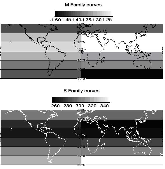
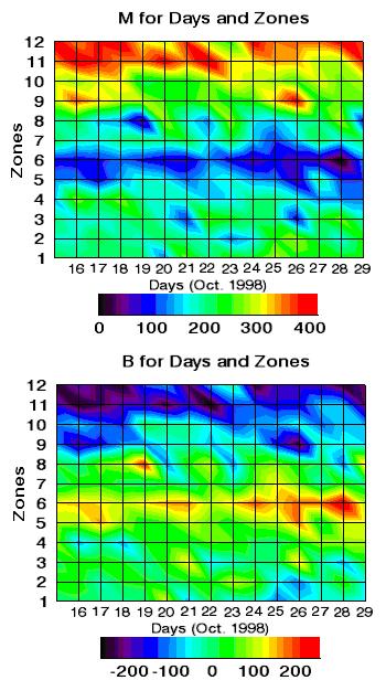
14 Empirical Parameters 14
15 Results Reflectivity Total Ozone Content
16 Ozone Monitoring 16

17 Monthly Average from OMAD 17

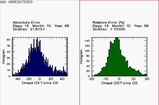
18 Ozone Depletion Errors increase with latitude and Albedo Relative errors lower than previous version. Absolute errors consistent with typical O 3 below cloud 18
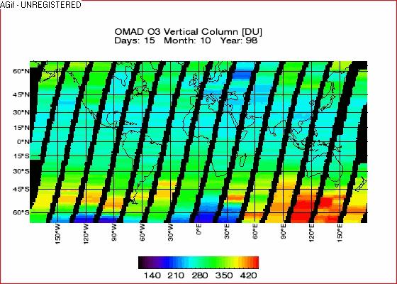
![Ozone latitude dependence Wide range of ozone concentrations from ~150 400 Dobson Units [DU] [1] Ozone concentration decrease for southern latitudes Errors increase for this region due to the large](/docs-images/92/109454638/images/19-3.jpg "solar zenith angles Polar Stratospheric Clouds near the poles are normally developed, it is expected that the errors in these regions will be greater. [1] 1 DU = 10-3 atmosphere cm i.e. 100 DU = 1mm thickness of gas at standard temperature and pressure.")
19 Ozone latitude dependence Wide range of ozone concentrations from ~ Dobson Units [DU] [1] Ozone concentration decrease for southern latitudes Errors increase for this region due to the large solar zenith angles Polar Stratospheric Clouds near the poles are normally developed, it is expected that the errors in these regions will be greater. [1] 1 DU = 10-3 atmosphere cm i.e. 100 DU = 1mm thickness of gas at standard temperature and pressure. 19


20 Relative Errors Errors are almost constant throughout the period under analysis Offset in the beginning of the depletion due to overestimation Areas with reflectivities < 70 % were analysed, errors are expected to decrease for lower reflectivities Histogram of errors is consistent over the period under analysis 20

21 Errors in Ozone Measurements Errors increase with latitude and Albedo Relative errors lower than previous version. Absolute errors consistent with typical O 3 below cloud Zones M B Absolute 1-Sigma Error in OMAD O3 [DU] Relative 1-Sigma Error in OMAD O3 [%] Reflectivity 20% 20% 50% 40% 30% 20% 50% 40% 30% 20% All Regions Average Errors % 3.67% 3.33% 2.90% 21


22 Nyamuragira Eruption Nyamuragira volcano Oct 1998 (Rep. Dem. Congo) Nadir only, long revisit time and inadequate spectral resolution preclude this application Ozone Anomaly found during the data processing Indicator of volcanic activity (release of SO 2 ) Only qualitative agreement 22
23 Conclusions Improved empirical algorithm is also valid in higher latitudes with oblique solar angles and extreme variations due to the seasonal Ozone depletion Total Ozone Content Relative errors <10% Atmospheric monitoring capabilities of microsatellites were greater than expected New potential for future instrumentation and retrieval algorithms on microsatellites Low-cost alternative to provide additional observations for atmospheric monitoring 23
24 Thank you for your attention Questions? 24
25 Reflectivity: Errors and Correlation 1-sigma error from ranges from (mean 14.5 ) Correlation > 0.9 for 90% of the period under evaluation Different pixel sizes, cloud cover and timing of overpasses Also explained by calibration errors and differences in spectral bands Aerosols are ignored for simplicity 25
26 OMAD vs TOMS The maximum ozone concentration decreases between November and December when depletion is at its minimum. Most of the scattered points are concentrated in the DU range in October as opposed to the DU in November and the DU range in early December. 26
Comparison of Results Between the Miniature FASat-Bravo Ozone Mapping Detector (OMAD) and NASA s Total Ozone Mapping Spectrometer (TOMS)
 and NASA s Total Ozone Mapping Spectrometer (TOMS)") SSC08-VI-7 Comparison of Results Between the Miniature FASat-Bravo Ozone Mapping Detector (OMAD) and NASA s Total Ozone Mapping Spectrometer (TOMS) Juan A. Fernandez-Saldivar, Craig I. Underwood Surrey
SSC08-VI-7 Comparison of Results Between the Miniature FASat-Bravo Ozone Mapping Detector (OMAD) and NASA s Total Ozone Mapping Spectrometer (TOMS) Juan A. Fernandez-Saldivar, Craig I. Underwood Surrey
Chapter 4 Nadir looking UV measurement. Part-I: Theory and algorithm
 Chapter 4 Nadir looking UV measurement. Part-I: Theory and algorithm -Aerosol and tropospheric ozone retrieval method using continuous UV spectra- Atmospheric composition measurements from satellites are
Simulated Radiances for OMI
 Simulated Radiances for OMI document: KNMI-OMI-2000-004 version: 1.0 date: 11 February 2000 author: J.P. Veefkind approved: G.H.J. van den Oord checked: J. de Haan Index 0. Abstract 1. Introduction 2.
GSICS UV Sub-Group Activities
 GSICS UV Sub-Group Activities Rosemary Munro with contributions from NOAA, NASA and GRWG UV Subgroup Participants, in particular L. Flynn 1 CEOS Atmospheric Composition Virtual Constellation Meeting (AC-VC)
GMES: calibration of remote sensing datasets
 GMES: calibration of remote sensing datasets Jeremy Morley Dept. Geomatic Engineering jmorley@ge.ucl.ac.uk December 2006 Outline Role of calibration & validation in remote sensing Types of calibration
Coordinating and Integrating UV Observations in Svalbard
 Coordinating and Integrating UV Observations in Svalbard Georg Hansen & Tove Svendby, NILU, Norway Boyan Petkov & Vito Vitale, ISAC-CNR, Italy Piotr Sobolwski, IGFPAS, Poland Josef Elster, University of
TOTAL COLUMN OZONE AND SOLAR UV-B ERYTHEMAL IRRADIANCE OVER KISHINEV, MOLDOVA
 Global NEST Journal, Vol 8, No 3, pp 204-209, 2006 Copyright 2006 Global NEST Printed in Greece. All rights reserved TOTAL COLUMN OZONE AND SOLAR UV-B ERYTHEMAL IRRADIANCE OVER KISHINEV, MOLDOVA A.A. ACULININ
Solar Insolation and Earth Radiation Budget Measurements
 Week 13: November 19-23 Solar Insolation and Earth Radiation Budget Measurements Topics: 1. Daily solar insolation calculations 2. Orbital variations effect on insolation 3. Total solar irradiance measurements
Using visible spectra to improve sensitivity to near-surface ozone of UV-retrieved profiles from MetOp GOME-2
 Using visible spectra to improve sensitivity to near-surface ozone of UV-retrieved profiles from MetOp GOME-2 Richard Siddans, Georgina Miles, Brian Kerridge STFC Rutherford Appleton Laboratory (RAL),
Long-Term Time Series of Water Vapour Total Columns from GOME, SCIAMACHY and GOME-2
 Graphics: ESA Graphics: ESA Graphics: ESA Long-Term Time Series of Water Vapour Total Columns from GOME, SCIAMACHY and GOME-2 S. Noël, S. Mieruch, H. Bovensmann, J. P. Burrows Institute of Environmental
Surface UV Irradiance Obtained by Ozone Monitoring Instrument (OMI) Over Peninsular Malaysia
 Over Peninsular Malaysia") Pertanika J. Sci. & Technol. 19 (S): 125-129 (2011) ISSN: 0128-7680 Universiti Putra Malaysia Press Surface UV Irradiance Obtained by Ozone Monitoring Instrument (OMI) Over Peninsular Malaysia N. H. Hisamuddin
Pertanika J. Sci. & Technol. 19 (S): 125-129 (2011) ISSN: 0128-7680 Universiti Putra Malaysia Press Surface UV Irradiance Obtained by Ozone Monitoring Instrument (OMI) Over Peninsular Malaysia N. H. Hisamuddin
MSI aerosol retrieval algorithm for the Multi- Spectral Imager (MSI) on EarthCare
 on EarthCare") MSI aerosol retrieval algorithm for the Multi- Spectral Imager (MSI) on EarthCare Wolfgang von Hoyningen-Huene Huene,, Alexander Kokhanovsky, Vladimir Rozanov,, John P. Burrows,, Gerard Hesselmans 2),
MSI aerosol retrieval algorithm for the Multi- Spectral Imager (MSI) on EarthCare Wolfgang von Hoyningen-Huene Huene,, Alexander Kokhanovsky, Vladimir Rozanov,, John P. Burrows,, Gerard Hesselmans 2),
). It is a gas produced naturally in the stratosphere where it strongly absorbs incoming
. It is a gas produced naturally in the stratosphere where it strongly absorbs incoming") Page 1 of 6 What Determines How Much Ultraviolet Radiation Reaches the Earth s Surface? The amount of UV radiation reaching the Earth s surface varies widely around the globe and through time. Several
Page 1 of 6 What Determines How Much Ultraviolet Radiation Reaches the Earth s Surface? The amount of UV radiation reaching the Earth s surface varies widely around the globe and through time. Several
Validation of GOME-2 MetopA and MetopB ozone profiles M. Hess 1, W. Steinbrecht 1, L. Kins 1, O. Tuinder 2 1 DWD, 2 KNMI.
 Validation of GOME-2 MetopA and MetopB ozone profiles M. Hess 1, W. Steinbrecht 1, L. Kins 1, O. Tuinder 2 1 DWD, 2 KNMI Introduction The GOME-2 instruments on the MetopA and MetopB satellites measure
What are Aerosols? Suspension of very small solid particles or liquid droplets Radii typically in the range of 10nm to
 What are Aerosols? Suspension of very small solid particles or liquid droplets Radii typically in the range of 10nm to 10µm Concentrations decrease exponentially with height N(z) = N(0)exp(-z/H) Long-lived
Atmospheric Lidar The Atmospheric Lidar (ATLID) is a high-spectral resolution lidar and will be the first of its type to be flown in space.
 is a high-spectral resolution lidar and will be the first of its type to be flown in space.") www.esa.int EarthCARE mission instruments ESA s EarthCARE satellite payload comprises four instruments: the Atmospheric Lidar, the Cloud Profiling Radar, the Multi-Spectral Imager and the Broad-Band Radiometer.
www.esa.int EarthCARE mission instruments ESA s EarthCARE satellite payload comprises four instruments: the Atmospheric Lidar, the Cloud Profiling Radar, the Multi-Spectral Imager and the Broad-Band Radiometer.
Volcanic & Air Quality SO2 Service -- Product Information
 TEMIS PROMOTE SACS Volcanic & Air Quality SO2 Service Product Information Document date: 15 January 2008 Data & Service version: 103, S-07 Introduction Sulphur dioxide (SO2) enters the atmosphere as a
A new perspective on aerosol direct radiative effects in South Atlantic and Southern Africa
 A new perspective on aerosol direct radiative effects in South Atlantic and Southern Africa Ian Chang and Sundar A. Christopher Department of Atmospheric Science University of Alabama in Huntsville, U.S.A.
Verification of Sciamachy s Reflectance over the Sahara J.R. Acarreta and P. Stammes
 Verification of Sciamachy s Reflectance over the Sahara J.R. Acarreta and P. Stammes Royal Netherlands Meteorological Institute P.O. Box 201, 3730 AE de Bilt, The Netherlands Email Address: acarreta@knmi.nl,
MSG system over view
 MSG system over view 1 Introduction METEOSAT SECOND GENERATION Overview 2 MSG Missions and Services 3 The SEVIRI Instrument 4 The MSG Ground Segment 5 SAF Network 6 Conclusions METEOSAT SECOND GENERATION
Radiation in the atmosphere
 Radiation in the atmosphere Flux and intensity Blackbody radiation in a nutshell Solar constant Interaction of radiation with matter Absorption of solar radiation Scattering Radiative transfer Irradiance
5.6. Barrow, Alaska, USA
 SECTION 5: QUALITY CONTROL SUMMARY 5.6. Barrow, Alaska, USA The Barrow installation is located on Alaska s North Slope at the edge of the Arctic Ocean in the city of Barrow. The instrument is located in
Spectral surface albedo derived from GOME-2/Metop measurements
 Spectral surface albedo derived from GOME-2/Metop measurements Bringfried Pflug* a, Diego Loyola b a DLR, Remote Sensing Technology Institute, Rutherfordstr. 2, 12489 Berlin, Germany; b DLR, Remote Sensing
1. The frequency of an electromagnetic wave is proportional to its wavelength. a. directly *b. inversely
 CHAPTER 3 SOLAR AND TERRESTRIAL RADIATION MULTIPLE CHOICE QUESTIONS 1. The frequency of an electromagnetic wave is proportional to its wavelength. a. directly *b. inversely 2. is the distance between successive
Long-term time-series of height-resolved ozone for nadir-uv spectrometers: CCI and beyond
 Long-term time-series of height-resolved ozone for nadir-uv spectrometers: CCI and beyond Richard Siddans, Georgina Miles, Barry Latter, Brian Kerridge RAL Earth Observation & Atmospheric Science Division,
Surface UV Irradiance from OMI on EOS Aura. Atmospheric Science Conference ESRIN, 8-12 May 2006 Aapo Tanskanen
 Surface UV Irradiance from OMI on EOS Aura Atmospheric Science Conference ESRIN, 8-12 May 2006 Aapo Tanskanen Contents OMI Surface UV Algorithm N. Krotkov /GEST Center, University of Maryland J. Herman
Mission Objectives and Current Status of GOSAT (IBUKI) Japan Aerospace Exploration Agency Yasushi Horikawa
 Japan Aerospace Exploration Agency Yasushi Horikawa") Mission Objectives and Current Status of GOSAT (IBUKI) Japan Aerospace Exploration Agency Yasushi Horikawa 1 Background of the Launch of the GOSAT project 1997 Adoption of the Kyoto Protocol 2002 Ratification
Mission Objectives and Current Status of GOSAT (IBUKI) Japan Aerospace Exploration Agency Yasushi Horikawa 1 Background of the Launch of the GOSAT project 1997 Adoption of the Kyoto Protocol 2002 Ratification
SCIAMACHY Level 1b-2 Data Processing Status & Changes
 SCIAMACHY Level 1b-2 Data Processing Status & Changes Albrecht von Bargen ACVE-2 Workshop, Frascati, Italy May 3 rd, 2004 SCIAMACHY Level 1b-2: Data Processing Status & Changes Contents Data Processor
K. Chance, R.J.D. Spun, and T.P. Kurosu. Harvard-Smithsonian Center for Astrophysics 60 Garden Street, Cambridge, MA USA ABSTRACT
 Atmospheric Trace Gas Measurements from the European Space Agency's Global Ozone Monitoring Experiment K. Chance, R.J.D. Spun, and T.P. Kurosu Harvard-Smithsonian Center for Astrophysics Garden Street,
Measured Ozone Depletion
 Measured Ozone Depletion Global Ozone After carefully accounting for all of the known natural variations, a net decrease of about 3% per decade for the period 1978-1991 was found. This is a global average
Solar Cycle 24 Variability Observed by Aura OMI Matthew DeLand and Sergey Marchenko Science Systems and Applications, Inc. (SSAI)
") Solar Cycle 24 Variability Observed by Aura OMI Matthew DeLand and Sergey Marchenko Science Systems and Applications, Inc. (SSAI) 2014 SORCE Science Meeting Cocoa Beach, FL 28-31 January 2014 Solar Measurements
Solar Cycle 24 Variability Observed by Aura OMI Matthew DeLand and Sergey Marchenko Science Systems and Applications, Inc. (SSAI) 2014 SORCE Science Meeting Cocoa Beach, FL 28-31 January 2014 Solar Measurements
The EarthCARE mission: An active view on aerosols, clouds and radiation
 The EarthCARE mission: An active view on aerosols, clouds and radiation T. Wehr, T. Fehr, P. Ingmann, J. v. Bismarck ESRIN, Frascati, Italy 20/10/2015 EARTH Clouds, Aerosols and Radiation Explorer EarthCARE
Antarctic Cloud Radiative Forcing at the Surface Estimated from the AVHRR Polar Pathfinder and ISCCP D1 Datasets,
 JUNE 2003 PAVOLONIS AND KEY 827 Antarctic Cloud Radiative Forcing at the Surface Estimated from the AVHRR Polar Pathfinder and ISCCP D1 Datasets, 1985 93 MICHAEL J. PAVOLONIS Cooperative Institute for
Calculation of total column ozone from global UV spectra at high latitudes
 JOURNAL OF GEOPHYSICAL RESEARCH, VOL. 108, NO. D17, 4532, doi:10.1029/2003jd003450, 2003 Calculation of total column ozone from global UV spectra at high latitudes G. Bernhard and C. R. Booth Biospherical
SBUV(/2) and SSBUV Solar Irradiance Measurements Matthew DeLand, Richard Cebula, Liang-Kang Huang Science Systems and Applications, Inc.
 and SSBUV Solar Irradiance Measurements Matthew DeLand, Richard Cebula, Liang-Kang Huang Science Systems and Applications, Inc.") SBUV(/2) and SSBUV Solar Irradiance Measurements Matthew DeLand, Richard Cebula, Liang-Kang Huang Science Systems and Applications, Inc. (SSAI) Solar Spectral Irradiance Variations Workshop NIST, Gaithersburg,
SBUV(/2) and SSBUV Solar Irradiance Measurements Matthew DeLand, Richard Cebula, Liang-Kang Huang Science Systems and Applications, Inc. (SSAI) Solar Spectral Irradiance Variations Workshop NIST, Gaithersburg,
Determination of aerosol optical depth using a Micro Total Ozone Spectrometer II. (MICROTOPS II) sun-photometer
 sun-photometer") Determination of aerosol optical depth using a Micro Total Ozone Spectrometer II (MICROTOPS II) sun-photometer Agossa Segla, Antonio Aguirre, and VivianaVladutescu Office of Educational Program (FAST Program)
Determination of aerosol optical depth using a Micro Total Ozone Spectrometer II (MICROTOPS II) sun-photometer Agossa Segla, Antonio Aguirre, and VivianaVladutescu Office of Educational Program (FAST Program)
Capabilities of IRS-MTG to sound ozone, CO and methane using ESA pre-phase A specifications
 Capabilities of IRS-MTG to sound ozone, CO and methane using ESA pre-phase A specifications Task 2: Ozone from a synergetic use of UV and IR radiances P. Coheur, C. Clerbaux, D. Hurtmans, J. Hadji-Lazaro,
Validation of the Aura Ozone Monitoring Instrument total column ozone product
 JOURNAL OF GEOPHYSICAL RESEARCH, VOL. 113,, doi:10.1029/2007jd008802, 2008 Validation of the Aura Ozone Monitoring Instrument total column ozone product R. McPeters, 1 M. Kroon, 2 G. Labow, 3 E. Brinksma,
METRIC tm. Mapping Evapotranspiration at high Resolution with Internalized Calibration. Shifa Dinesh
 METRIC tm Mapping Evapotranspiration at high Resolution with Internalized Calibration Shifa Dinesh Outline Introduction Background of METRIC tm Surface Energy Balance Image Processing Estimation of Energy
*C. Pan 1, F. Weng 2, T. Beck 2 and S. Ding 3
 S NPP Ozone Mapping Profiler Suite Nadir Instrument Radiometric Calibration *C. Pan 1, F. Weng 2, T. Beck 2 and S. Ding 3 Curtsey of Ball Aerospace and Technologies Corp. * 1 ESSIC, University of Maryland,
RadCalNet Quick Start Guide. RadCalNet Quick Start Guide
 RadCalNet Quick Start Guide RadCalNet Quick Start Guide 1. Scope of the document... 2 2. How to access the RadCalNet data?... 2 3. RadCalNet: which data for which purpose?... 2 4. How to use the data?...
The EarthCARE mission: An active view on aerosols, clouds and radiation
 The EarthCARE mission: An active view on aerosols, clouds and radiation T. Wehr, P. Ingmann, T. Fehr Heraklion, Crete, Greece 08/06/2015 EarthCARE is ESA s sixths Earth Explorer Mission and will be implemented
Progress Towards an Absolute Calibration of Lunar Irradiance at Reflected Solar Wavelengths
 Progress Towards an Absolute Calibration of Lunar Irradiance at Reflected Solar Wavelengths Claire Cramer, Steve Brown, Keith Lykke, John Woodward (NIST) Tom Stone (USGS) Motivation for using the Moon
Influence of Clouds and Aerosols on the Earth s Radiation Budget Using Clouds and the Earth s Radiant Energy System (CERES) Measurements
 Measurements") Influence of Clouds and Aerosols on the Earth s Radiation Budget Using Clouds and the Earth s Radiant Energy System (CERES) Measurements Norman G. Loeb Hampton University/NASA Langley Research Center Bruce
Influence of Clouds and Aerosols on the Earth s Radiation Budget Using Clouds and the Earth s Radiant Energy System (CERES) Measurements Norman G. Loeb Hampton University/NASA Langley Research Center Bruce
Sumi-NPP OMPS Calibration and Characterization from Early Orbit Images
 Sumi-NPP OMPS Calibration and Characterization from Early Orbit Images *C. Pan 1, F. Weng 2, X. Wu 2, L. Flynn 2, G. Jaross 3 and S. Janz 4 * 1 ESSIC, University of Maryland, College Park, MD 20740 2 NOAA
Current Status of the Stratospheric Ozone Layer From: UNEP Environmental Effects of Ozone Depletion and Its Interaction with Climate Change
 Goals Produce a data product that allows users to acquire time series of the distribution of UV-B radiation across the continental USA, based upon measurements from the UVMRP. Provide data in a format
A AVHRR NDVI dataset for Svalbard. Stian Solbø, Inge Lauknes, Cecilie Sneberg Grøtteland, Stine Skrunes, Hannah Vickers, Kjell Arild Høgda
 A 1986-2014 AVHRR NDVI dataset for Svalbard Stian Solbø, Inge Lauknes, Cecilie Sneberg Grøtteland, Stine Skrunes, Hannah Vickers, Kjell Arild Høgda AVHRR series of satellites/instruments Satellite name
ATMS 321: Sci. of Climate Final Examination Study Guide Page 1 of 4
 ATMS 321: Sci. of Climate Final Examination Study Guide Page 1 of 4 Atmospheric Sciences 321: Final Examination Study Guide The final examination will consist of similar questions Science of Climate Multiple
Reprocessed GOME-2 Absorbing Aerosol Index product
 REFERENCE: ISSUE: DATE: PAGES: 2/2016 1 March 2016 46 O3M SAF VALIDATION REPORT Reprocessed GOME-2 Absorbing Aerosol Index product Product Identifier O3M-113 O3M-179 O3M-178 O3M-180 Product Name Reprocessed
Total ozone (Dobson units) Total ozone (Dobson units) 500
 Total ozone (Dobson units) 500") Representation of ozone in the ECMWF model A. Dethof and E. Hólm European Centre for Medium-Range Weather Forecasts 1 Introduction Ozone is fully integrated into the ECMWF forecast model and analysis system
Representation of ozone in the ECMWF model A. Dethof and E. Hólm European Centre for Medium-Range Weather Forecasts 1 Introduction Ozone is fully integrated into the ECMWF forecast model and analysis system
Sentinel-3 Sea and Land Surface Temperature Radiometer (SLSTR) Mireya Etxaluze (STFC RAL Space)
 Mireya Etxaluze (STFC RAL Space)") Sentinel-3 Sea and Land Surface Temperature Radiometer (SLSTR) Mireya Etxaluze (STFC RAL Space) RAL Space Radiometry Group Dave Smith Mireya Etxaluze, Ed Polehampton, Caroline Cox, Tim Nightingale, Dan
Sentinel-3 Sea and Land Surface Temperature Radiometer (SLSTR) Mireya Etxaluze (STFC RAL Space) RAL Space Radiometry Group Dave Smith Mireya Etxaluze, Ed Polehampton, Caroline Cox, Tim Nightingale, Dan
UK-DMC 2 and Deimos-1, New DMC Sensors for Agricultural Monitoring. Owen Hawkins DMC International Imaging Ltd
 UK-DMC 2 and Deimos-1, New DMC Sensors for Agricultural Monitoring Owen Hawkins DMC International Imaging Ltd Full Spectrum Satellite Solutions Design Manufacture Assembly, Integration & Test Launch Services
Mike Fromm, Naval Research Laboratory Washington, DC
 a b c Mike Fromm, Naval Research Laboratory Washington, DC d Particlelarly Interesting Science: the Meaning, Marvels and Mysteries of Pyrocumulonimbus Grimsvötn (Iceland) volcano June 2011 Warm Fire (Arizona)
Algorithms/Results (SO 2 and ash) based on SCIAMACHY and GOME-2 measurements
 based on SCIAMACHY and GOME-2 measurements") ESA/EUMETSAT Workshop on Volcanic Ash Monitoring ESA/ESRIN, Frascati, 26-27 May 2010 Algorithms/Results (SO 2 and ash) based on SCIAMACHY and GOME-2 measurements Nicolas THEYS H. Brenot, J. van Gent and
ESA/EUMETSAT Workshop on Volcanic Ash Monitoring ESA/ESRIN, Frascati, 26-27 May 2010 Algorithms/Results (SO 2 and ash) based on SCIAMACHY and GOME-2 measurements Nicolas THEYS H. Brenot, J. van Gent and
HICO Calibration and Atmospheric Correction
 HICO Calibration and Atmospheric Correction Curtiss O. Davis College of Earth Ocean and Atmospheric Sciences Oregon State University, Corvallis, OR, USA 97331 cdavis@coas.oregonstate.edu Oregon State Introduction
APPLICATIONS WITH METEOROLOGICAL SATELLITES. W. Paul Menzel. Office of Research and Applications NOAA/NESDIS University of Wisconsin Madison, WI
 APPLICATIONS WITH METEOROLOGICAL SATELLITES by W. Paul Menzel Office of Research and Applications NOAA/NESDIS University of Wisconsin Madison, WI July 2004 Unpublished Work Copyright Pending TABLE OF CONTENTS
A two-season impact study of the Navy s WindSat surface wind retrievals in the NCEP global data assimilation system
 A two-season impact study of the Navy s WindSat surface wind retrievals in the NCEP global data assimilation system Li Bi James Jung John Le Marshall 16 April 2008 Outline WindSat overview and working
JOURNAL OF GEOPHYSICAL RESEARCH, VOL. 116, D18301, doi: /2011jd015808, 2011
 JOURNAL OF GEOPHYSICAL RESEARCH, VOL. 116,, doi:10.1029/2011jd015808, 2011 Retrievals of sulfur dioxide from the Global Ozone Monitoring Experiment 2 (GOME 2) using an optimal estimation approach: Algorithm
UV-Vis Nadir Retrievals
 SCIAMACHY book UV-Vis Nadir Retrievals Michel Van Roozendael, BIRA-IASB ATC14, 27-31 October, Jülich, Germany Introduction Content Fundamentals of the DOAS method UV-Vis retrievals: from simplified to
Improved ozone profile retrievals from GOME data with degradation correction in reflectance
 Atmos. Chem. Phys., 7, 1575 1583, 2007 Author(s) 2007. This work is licensed under a Creative Commons License. Atmospheric Chemistry and Physics Improved ozone profile retrievals from GOME data with degradation
Observations of Integrated Water Vapor and Cloud Liquid Water at SHEBA. James Liljegren
 Observations of Integrated Water Vapor and Cloud Liquid Water at SHEBA James Liljegren Ames Laboratory Ames, IA 515.294.8428 liljegren@ameslab.gov Introduction In the Arctic water vapor and clouds influence
Volcanoes drive climate variability by
 Volcanoes drive climate variability by 1. emitting ozone weeks before eruptions, 2. forming lower stratospheric aerosols that cool Earth, 3. causing sustained ozone depletion, surface warming, and lower
TRUTHS-Lite: A Microsatellite Based Climate Benchmark Mission
 IAA-B10-0404 TRUTHS-Lite: A Microsatellite Based Climate Benchmark Mission Craig Underwood 1, Nigel Fox 2, Javier Gorroño 2 1 Surrey Space Centre, University of Surrey, Guildford, Surrey, GU2 7XH, UK 2
Atmospheric Correction Using Hyperion
 Atmospheric Correction Using Hyperion Progress and Issues Investigation: Correlative Analysis of EO-1, Landsat, and Terra Data of the DOE ARM CART Sites: An Investigation of Instrument Performance and
OMI total ozone column validation with Aura-AVE CAFS observations
 Click Here for Full Article JOURNAL OF GEOPHYSICAL RESEARCH, VOL. 113,, doi:10.1029/2007jd008795, 2008 OMI total ozone column validation with Aura-AVE CAFS observations M. Kroon, 1 I. Petropavlovskikh,
SCIAMACHY REFLECTANCE AND POLARISATION VALIDATION: SCIAMACHY VERSUS POLDER
 SCIAMACHY REFLECTANCE AND POLARISATION VALIDATION: SCIAMACHY VERSUS POLDER L. G. Tilstra (1), P. Stammes (1) (1) Royal Netherlands Meteorological Institute (KNMI), P.O. Box 201, 3730 AE de Bilt, The Netherlands
McIDAS support of Suomi-NPP /JPSS and GOES-R L2
 McIDAS support of Suomi-NPP /JPSS and GOES-R L2 William Straka III 1 Tommy Jasmin 1, Bob Carp 1 1 Cooperative Institute for Meteorological Satellite Studies, Space Science and Engineering Center, University
Ozone profile retrievals from the Ozone Monitoring Instrument
 Author(s) 2010. This work is distributed under the Creative Commons Attribution 3.0 License. Atmospheric Chemistry and Physics Ozone profile retrievals from the Ozone Monitoring Instrument X. Liu 1,2,3,
Calibration of MERIS on ENVISAT Status at End of 2002
 Calibration of MERIS on ENVISAT Status at End of 2002 Bourg L. a, Delwart S. b, Huot J-P. b a ACRI-ST, 260 route du Pin Montard, BP 234, 06904 Sophia-Antipolis Cedex, France b ESA/ESTEC, P.O. Box 299,
Chapter 11 Lecture Outline. Heating the Atmosphere
 Chapter 11 Lecture Outline Heating the Atmosphere They are still here! Focus on the Atmosphere Weather Occurs over a short period of time Constantly changing Climate Averaged over a long period of time
Scientific Challenges of UV-B Forecasting
 Scientific Challenges of UV-B Forecasting Henning Staiger, German Meteorological Service (DWD) International activities and the UV Index UV Index definition and forecasting requirements Challenges in calculation
Module 1, Investigation 2: Log Sensing volcanic effects from space
 Module 1, Investigation 2: Log Sensing volcanic effects from space Background Volcanoes are extremely disruptive and destructive to the environment and to the people who live nearby. They may disrupt the
HARP Assessment of Uncertainty
 HARP Assessment of Uncertainty The HIAPER Airborne Radiation Package (HARP) was designed to produce accurate measurements of actinic flux and irradiance. The Atmospheric Radiation Group (ARG) at the University
Simultaneous spectral albedo measurements near the Atmospheric Radiation Measurement Southern Great Plains (ARM SGP) central facility
 central facility") JOURNAL OF GEOPHYSICAL RESEARCH, VOL. 108, NO. D8, 4254, doi:10.1029/2002jd002906, 2003 Simultaneous spectral albedo measurements near the Atmospheric Radiation Measurement Southern Great Plains (ARM SGP)
JOURNAL OF GEOPHYSICAL RESEARCH, VOL. 108, NO. D8, 4254, doi:10.1029/2002jd002906, 2003 Simultaneous spectral albedo measurements near the Atmospheric Radiation Measurement Southern Great Plains (ARM SGP)
MAPPING NATURAL SURFACE UV RADIATION WITH MSG: MAPS SERIES IN SPRING 2004, COMPARISON WITH METEOSAT DERIVED RESULTS AND REFERENCE MEASUREMENTS
 MAPPING NATURAL SURFACE UV RADIATION WITH MSG: MAPS SERIES IN SPRING 2004, COMPARISON WITH METEOSAT DERIVED RESULTS AND REFERENCE MEASUREMENTS Jean Verdebout & Julian Gröbner European Commission - Joint
Global Warming and Climate Change Part I: Ozone Depletion
 GCOE-ARS : November 18, 2010 Global Warming and Climate Change Part I: Ozone Depletion YODEN Shigeo Department of Geophysics, Kyoto University 1. Stratospheric Ozone and History of the Earth 2. Observations
U.K. Ozone and UV Trends and Extreme Events
 U.K. Ozone and UV Trends and Extreme Events Andrew C. Moss, Andrew R.D. Smedley and John S. Rimmer University of Manchester Acknowledgements: UKMO, DEFRA Workshop, Beijing 211 Introduction Overview of
Assessing the Radiative Impact of Clouds of Low Optical Depth
 Assessing the Radiative Impact of Clouds of Low Optical Depth W. O'Hirok and P. Ricchiazzi Institute for Computational Earth System Science University of California Santa Barbara, California C. Gautier
Derivation of Aerosol Properties From Satellite Measurements of Backscattered Ultraviolet Radiation. Theoretical Basis
 Derivation of Aerosol Properties From Satellite Measurements of Backscattered Ultraviolet Radiation. Theoretical Basis O. Torres 1, P.K. Bhartia 2, J.R.Herman 2, and Z. Ahmad 3 Abstract We discuss the
Hyperspectral Atmospheric Correction
 Hyperspectral Atmospheric Correction Bo-Cai Gao June 2015 Remote Sensing Division Naval Research Laboratory, Washington, DC USA BACKGROUND The concept of imaging spectroscopy, or hyperspectral imaging,
Early calibration problems detected in TOMS Earth-Probe aerosol signal
 1 2 3 Early calibration problems detected in TOMS Earth-Probe aerosol signal 4 5 P. Kiss, 1 I. M. Jánosi, 1 and O. Torres 2 6 7 8 9 10 1 Department of Physics of Complex Systems, Loránd Eötvös University,
Overview of The CALIPSO Mission
 Overview of The CALIPSO Mission Dave Winker NASA-LaRC LaRC,, PI Jacques Pelon IPSL/CNRS, co-pi Research Themes Improved understanding of the Earth s climate system is a primary goal of the Scientific Community
- global radiative energy balance
 (1 of 14) Further Reading: Chapter 04 of the text book Outline - global radiative energy balance - insolation and climatic regimes - composition of the atmosphere (2 of 14) Introduction Last time we discussed
The Impact of Using Different Ozone Cross Sections on Ozone Profile Retrievals from OMI UV Measurements
 The Impact of Using Different Ozone Cross Sections on Ozone Profile Retrievals from OMI UV Measurements Xiong Liu, Cheng Liu, Kelly Chance xliu@cfa.harvard.edu Harvard-Smithsonian Center for Astrophysics
MERIS SMILE EFFECT CHARACTERISATION AND CORRECTION DOCUMENT. document title/ titre du document. prepared by/préparé par MERIS ESL
 DOCUMENT document title/ titre du document MERIS SMILE EFFECT CHARACTERISATION AND CORRECTION prepared by/préparé par MERIS ESL reference/réference issue/édition 2 revision/révision 0 date of issue/date
ERBE Geographic Scene and Monthly Snow Data
 NASA Contractor Report 4773 ERBE Geographic Scene and Monthly Snow Data Lisa H. Coleman, Beth T. Flug, Shalini Gupta, Edward A. Kizer, and John L. Robbins Science Applications International Corporation
Aura Microwave Limb Sounder (MLS) ozone profile data record characteristics, quality and applications
 ozone profile data record characteristics, quality and applications") Aura Microwave Limb Sounder (MLS) ozone profile data record characteristics, quality and applications A presentation for the 2016 meeting of the Committee on Earth Observation Satellites (COES) Atmospheric
Aura Microwave Limb Sounder (MLS) ozone profile data record characteristics, quality and applications A presentation for the 2016 meeting of the Committee on Earth Observation Satellites (COES) Atmospheric
THE LAND-SAF SURFACE ALBEDO AND DOWNWELLING SHORTWAVE RADIATION FLUX PRODUCTS
 THE LAND-SAF SURFACE ALBEDO AND DOWNWELLING SHORTWAVE RADIATION FLUX PRODUCTS Bernhard Geiger, Dulce Lajas, Laurent Franchistéguy, Dominique Carrer, Jean-Louis Roujean, Siham Lanjeri, and Catherine Meurey
Long term DOAS measurements at Kiruna
 Long term DOAS measurements at Kiruna T. Wagner, U. Frieß, K. Pfeilsticker, U. Platt, University of Heidelberg C. F. Enell, A. Steen, Institute for Space Physics, IRF, Kiruna 1. Introduction Since 1989
A Method Suitable for In-flight Calibration of a UAV Hyperspectral Remote Sensor
 A Method Suitable for In-flight Calibration of a UAV Hyperspectral Remote Sensor Haiwei Li, Hao Zhang, Zhengchao Chen Institute of Remote Sensing and Digital Earth (RADI), Chinese Academy of Sciences (CAS)
Radiative forcing of fine ash and volcanic sulphate aerosol. sulphate aerosol after a very large Northern hemisphere mid-latitude eruption
 Radiative forcing of fine ash and volcanic sulphate aerosol after a very large Northern hemisphere mid-latitude eruption Ulrike Niemeier (1), Claudia Timmreck (1), Sebastian Rast (1), Marco Giorgetta (1),
HEATING THE ATMOSPHERE
 HEATING THE ATMOSPHERE Earth and Sun 99.9% of Earth s heat comes from Sun But
Detection of ship NO 2 emissions over Europe from satellite observations
 Detection of ship NO 2 emissions over Europe from satellite observations Huan Yu DOAS seminar 24 April 2015 Ship Emissions to Atmosphere Reporting Service (SEARS project) Outline Introduction Shipping
The MODIS Cloud Data Record
 The MODIS Cloud Data Record Brent C. Maddux 1,2 Steve Platnick 3, Steven A. Ackerman 1 Paul Menzel 1, Kathy Strabala 1, Richard Frey 1, 1 Cooperative Institute for Meteorological Satellite Studies, 2 Department
MERIS, A-MODIS, SeaWiFS, AATSR and PARASOL over the Salar de Uyuni March 2006 MAVT 2006 Marc Bouvet, ESA/ESTEC
 MERIS, A-MODIS, SeaWiFS, AATSR and PARASOL over the Salar de Uyuni Plan of the presentation 1. Introduction : from absolute vicarious calibration to radiometric intercomparison 2. Intercomparison at TOA
The O 2 A-band Spectrometer on the NASA Orbiting Carbon Observatory-2 (OCO-2)
") Workshop on Remote sensing in the O 2 A-band The O 2 A-band Spectrometer on the NASA Orbiting Carbon Observatory-2 (OCO-2) David Crisp for the OCO-2 Science Team Jet Propulsion Laboratory, California Institute
Workshop on Remote sensing in the O 2 A-band The O 2 A-band Spectrometer on the NASA Orbiting Carbon Observatory-2 (OCO-2) David Crisp for the OCO-2 Science Team Jet Propulsion Laboratory, California Institute
Characterization and correction of Global Ozone Monitoring Experiment 2 ultraviolet measurements and application to ozone profile retrievals
 JOURNAL OF GEOPHYSICAL RESEARCH, VOL. 117,, doi:10.1029/2011jd017096, 2012 Characterization and correction of Global Ozone Monitoring Experiment 2 ultraviolet measurements and application to ozone profile
MAPH & & & & & & 02 LECTURE
 Climate & Earth System Science Introduction to Meteorology & Climate MAPH 10050 Peter Lynch Peter Lynch Meteorology & Climate Centre School of Mathematical Sciences University College Dublin Meteorology
WATER VAPOUR RETRIEVAL FROM GOME DATA INCLUDING CLOUDY SCENES
 WATER VAPOUR RETRIEVAL FROM GOME DATA INCLUDING CLOUDY SCENES S. Noël, H. Bovensmann, J. P. Burrows Institute of Environmental Physics, University of Bremen, FB 1, P. O. Box 33 4 4, D 28334 Bremen, Germany
SATELLITE RETRIEVAL OF AEROSOL PROPERTIES OVER BRIGHT REFLECTING DESERT REGIONS
 SATELLITE RETRIEVAL OF AEROSOL PROPERTIES OVER BRIGHT REFLECTING DESERT REGIONS Tilman Dinter 1, W. von Hoyningen-Huene 1, A. Kokhanovsky 1, J.P. Burrows 1, and Mohammed Diouri 2 1 Institute of Environmental