TRUTHS-Lite: A Microsatellite Based Climate Benchmark Mission
|
|
|
- Marcus Rice
- 5 years ago
- Views:
Transcription
1 IAA-B TRUTHS-Lite: A Microsatellite Based Climate Benchmark Mission Craig Underwood 1, Nigel Fox 2, Javier Gorroño 2 1 Surrey Space Centre, University of Surrey, Guildford, Surrey, GU2 7XH, UK 2 National Physical Laboratory, Hampton Road, Teddington, Middlesex,TW11 0LW, UK c.underwood@surrey.ac.uk, nigel.fox@npl.co.uk, j.gorrono@surrey.ac.uk 10 th IAA Symposium on Small Satellites for Earth Observation, Berlin, Germany, April 2015
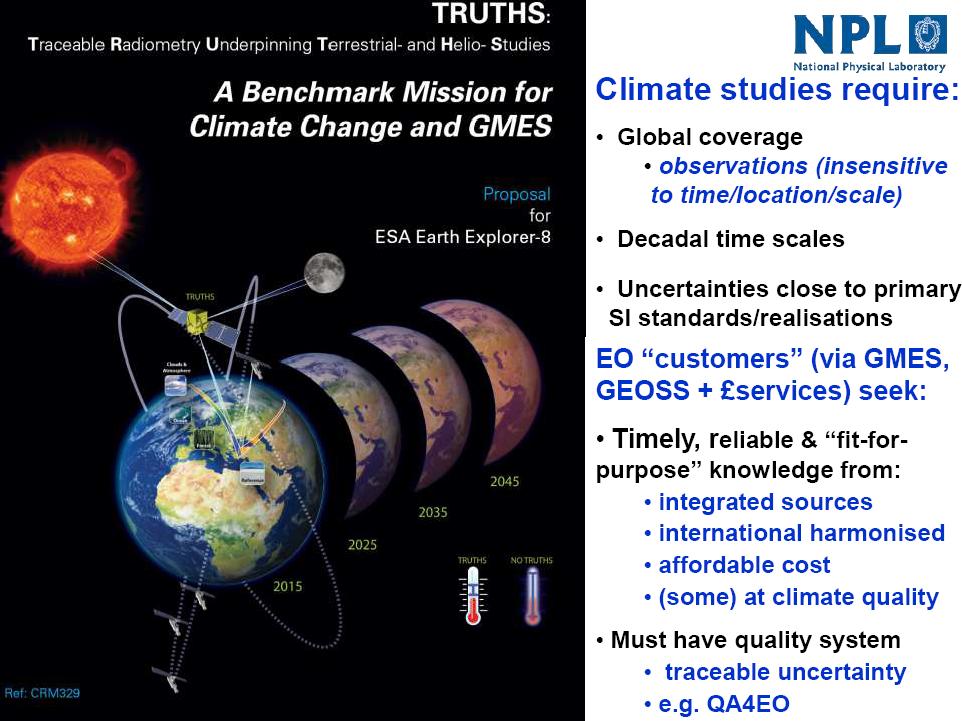
2 Introduction
3 Introduction

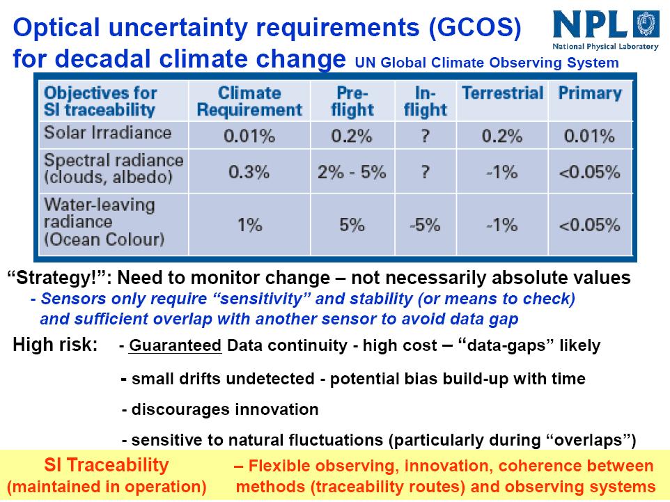
4 SI Traceability

5 TRUTHS

6 TRUTHS RADCALNET
7 TRUTHS
8 TRUTHS TRUTHS primary goal is to provide benchmark measurements of both incoming (solar) and outgoing (reflected solar) radiation. Measuring global spectrally resolved (10 nm) Earth radiances, continuously sampled (spectrally and spatially) with GIFOV of ~50m from nm and the corresponding solar spectral irradiances both with uncertainties traceable to SI units of <0.3% Although not selected in the ESA EE8 call, TRUTHS received a strong recommendation of support and encouragement that an early implementation should be explored as part of a wider international collaborative effort. In support of that goal this paper proposes a low-cost TRUTHS precursor mission (TRUTHS-Lite). This would offer risk reduction on the key enabling technologies of TRUTHS.
 and Potential TRUTHS-Lite Configuration (right) (images courtesy SSTL) Payload Instrument Mass Up to 45 kg Payload Volume Width 530 mm, Depth 430 mm, Height 400 mm Payload")
9 TRUTHS-Lite The TRUTHS-Lite mission would be based on a new 50kg microsatellite platform being developed by Surrey Satellite Technology Ltd. (SSTL) the SSTL-X50. SSTL X-50 Platform (left) and Potential TRUTHS-Lite Configuration (right) (images courtesy SSTL) Payload Instrument Mass Up to 45 kg Payload Volume Width 530 mm, Depth 430 mm, Height 400 mm Payload Orbit Average Power Typically 35 W Payload Peak Power Typically 85 W Payload Data Bus Gigabit per second to on-board storage or high speed downlink. Attitude Control Earth referenced or inertial; stability: 18 arc-seconds/second; knowledge: 10 arc-seconds; control 0.07 degrees Typical Orbit Low-Earth Orbit Sun-Synchronous Platform Lifetime 5 to 7 years Total Mass 50 kg typical up to 75 kg
10 Mission & Payload Concept The TRUTHS-Lite payload would be a cut-down version of that proposed for TRUTHS and would comprise just the key instruments: Cryogenic Solar Absolute Radiometer (CSAR) a self-contained SI primary standard, which includes an innovative cryo-cooler, and a total solar irradiance (TSI) cavity. Spectral Calibration Monochromator (SCM) an On-Board Calibration Reference light source used in conjunction with the CSAR.
")
 and Solar Spectral Irradiance Monitor (SSIM)")
11 Mission & Payload Concept The hyperspectral Earth Imager (EI) would have to be sacrificed from TRUTHS-Lite due to volume constraints, and this would be replaced by a simple (small) multi-spectral Earth Imaging Camera. Similarly, the Polarising Transfer Radiometer (PTR) and Solar Spectral Irradiance Monitor (SSIM) would not be carried. However, the EI could be flown on a companion satellite.

12 Mission & Payload Concept

. This will allow radiometric measurements to be made to an accuracy of 0.3%.")

13 Mission & Payload Concept When the spacecraft is in Sun-pointing mode, the CSAR instrument can measure the absolute radiance of the Sun over the spectral range 0.32 to 2.45 µm wavelength in 13 spectral bands with spectral bandwidths varying from 1 to 10 nm, via the On-Board Spectral Calibration Monochromator (SCM). This will allow radiometric measurements to be made to an accuracy of 0.3%. The Total Solar Irradiance (TSI) monitor measures the total solar irradiance over 0.2 to 35 µm wavelength to 0.01% accuracy by absorbing radiation into a blackbody cavity. By pointing the spacecraft at the Earth, similar measurements can be made of the Top of Atmosphere (ToA) reflected solar spectrum

14 Mission & Payload Concept Flying a companion hyperspectral imaging micro-satellite of a similar class would benefit both missions, in that it would provide extra information on the ground reference sites targeted by TRUTHS- Lite, whilst also providing a means of calibrating the hyperspectral data to an SI tracable standard. SSTL s CHRIS imager is available now, and CHRIS-2 is in development. Similarly, the ESA APEX instrument could be used. Parameter Value Mass 14kg Power (when imaging) <9W Focal length 746mm Field of view 1.24 Sensor array 748 x 748 CCD detector Digitisation 12 bit GSD 17m at 560km Swath width 13km at 560km Spectral resolution nm Spectral range nm Simultaneous 61 (34m GSD) half spatial resolution SSTL CHRIS Hyperspectral Imager

15 Mission & Payload Concept SSTL CHRIS-2 Earth Imager
, measurements can be made at times and locations to match a number of existing Earth-imaging spacecraft, thus allowing cross-calibration of their data")
16 Mission & Payload Concept By selecting a Sun-Synchronous orbit at approximately 600km altitude and approximately 10.30am Local Solar Time of Ascending Node (LTAN), measurements can be made at times and locations to match a number of existing Earth-imaging spacecraft, thus allowing cross-calibration of their data with an absolute, SI-traceable, radiometric standard. With a downlink capability of Mbps, the TRUTHS-Lite spacecraft would be able to return ~280 Gbit of data per day approximately 1/16 th of that of the full TRUTHS mission but without the need for transmitting the data-heavy (0.38 Gbit per image) hyperspectral images.
17 Cross-Calibration Tools Objective: estimation of the radiometric uncertainty of a crosscalibration using TRUTHS as a reference sensor output to update the cross-calibration methodology and instrument design. Structure: initial version of four independent modules addressing the major uncertainty contributions affecting a typical CEOS prioritized land based calibration site: surface altitude/slope, spectral response, aerosol content, and surface reflectance heterogeneity. Uncertainty methodology: Monte-Carlo Method for uncertainty propagation as in GUM-S1 and QA4EO cross-calibration uncertainty estimates based on probability distribution function of the associated parameters. Software implementation: Portable and accessible: open-source code (Python), embedded algorithms (e.g. slope calculation) and open-access libraries (e.g. GDAL) JASMIN supercomputer cluster: Memory and processing limitations overcome. Large memory units and code parallelization.
18 Spectra Module Inputs: DIMITRI ToA reflectance: reference spectrum interpolated at nm. Sentinel 2 spectral response interpolated at nm. TRUTHS Imager design: native sampling/resolution and binning. TRUTHS spectral response: triangular shape native bands (low aberration optical design). Sampling matches native resolution as FWM (slit width = pixel size) TRUTHS ToA measurement: Convolution with DIMITRI ToA at native bands and binning accounted for final TRUTHS bands Reconstruction of the DIMITRI ToA reflectance at same sampling steps using interpolation (justified by the low accuracy of TRUTHS measurements) and no-prior knowledge of the signal assumed (conservative approach).
19 Spectra Module Sampling/resolution error: the Sentinel 2 is convolved first with the ToA reflectance reference and then with the reconstructed one by TRUTHS. An error for each Sentinel 2 band is obtained.

20 Spectra Module Knowledge/stability uncertainty: the ToA reflectance using TRUTHS measurements is reconstructed and convolved with a Sentinel 2 band n times. A dispersion of the convolved ToA reflectance is obtained.
21 Conclusions (1) High precision radiometric data is required to enable the unequivocal detection of climate change with the ability to constrain and test climate forecast models on a decadal time scale. TRUTHS-Lite makes use of the new generation of small microsatellites, being developed by SSTL, to fly a key enabling technology the Cryogenic Solar Absolute Radiometer (CSAR) to provide very high precision radiometric calibration data traceable to SI standards. Flying a companion hyperspectral imaging micro-satellite of a similar class would benefit both missions, in that it would provide extra information on the ground reference sites targeted by TRUTHS-Lite, whilst also providing a means of accurately calibrating the hyperspectral data.
22 Conclusions (2) A series of tools are being developed to make use of TRUTHS data in the cross-calibration of other EO spacecraft e.g. DMC, SENTINEL-2, so that, ultimately their data can be traced back to National Metrology Institute (NMI) laboratory standards. The further development of this tool is envisaged, such that it will enable the full estimation of uncertainty in sensor to sensor cross-calibration in an automated manner. This Radiometric Uncertainty Tool is currently the subject of PhD research being carried out at the Surrey Space Centre, sponsored, supported and in conjunction with the UK National Physical Laboratory. The CSAR instrument is currently subject to development to TRL 5-6 under a 1M CEOI/Airbus D&S development programme.


23 Thank-You
Atmospheric Lidar The Atmospheric Lidar (ATLID) is a high-spectral resolution lidar and will be the first of its type to be flown in space.
 is a high-spectral resolution lidar and will be the first of its type to be flown in space.") www.esa.int EarthCARE mission instruments ESA s EarthCARE satellite payload comprises four instruments: the Atmospheric Lidar, the Cloud Profiling Radar, the Multi-Spectral Imager and the Broad-Band Radiometer.
www.esa.int EarthCARE mission instruments ESA s EarthCARE satellite payload comprises four instruments: the Atmospheric Lidar, the Cloud Profiling Radar, the Multi-Spectral Imager and the Broad-Band Radiometer.
Comparison of Results Between the Miniature FASat-Bravo Ozone Mapping Detector (OMAD) and NASA s Total Ozone Mapping Spectrometer (TOMS)
 and NASA s Total Ozone Mapping Spectrometer (TOMS)") SSC08-VI-7 Comparison of Results Between the Miniature FASat-Bravo Ozone Mapping Detector (OMAD) and NASA s Total Ozone Mapping Spectrometer (TOMS) Juan A. Fernandez-Saldivar, Craig I. Underwood Surrey
SSC08-VI-7 Comparison of Results Between the Miniature FASat-Bravo Ozone Mapping Detector (OMAD) and NASA s Total Ozone Mapping Spectrometer (TOMS) Juan A. Fernandez-Saldivar, Craig I. Underwood Surrey
Accuracy and Precision Requirements for Climate-Level Data Sets
 Accuracy and Precision Requirements for Climate-Level Data Sets K. Thome NASA/GSFC Libya-4 Workshop Paris, France October 4-5, 2012 Accuracy requirements Commercial imagers Precision and SNR drive calibration
The Earth Climate Hyperspectral Observatory: Advances in Climate Change Detection, Attribution, and Remote Sensing
 The Earth Climate Hyperspectral Observatory: Advances in Climate Change Detection, Attribution, and Remote Sensing Peter Pilewskie, Greg Kopp, Odele Coddington, Sebastian Schmidt, Tom Sparn University
Calibration of Ocean Colour Sensors
 Dr. A. Neumann German Aerospace Centre DLR Remote Sensing Technology Institute Marine Remote Sensing What is Calibration, why do we need it? Sensor Components Definition of Terms Calibration Standards
Sentinel-5 Precursor: Preparing the first Copernicus Atmospheric Mission
 Sentinel-5 Precursor: Preparing the first Copernicus Atmospheric Mission Herbert Nett 1, Kevin McMullan 1, Paul Ingmann 1, Thorsten Fehr 2 (1) ESA/ESTEC, Keplerlaan 1, NL-2201 AZ Noordwijk (2) ESA/ESRIN,
1.0 Introduction 1.1 The Earth Radiation Budget
 1.0 Introduction 1.1 The Earth Radiation Budget The ability of man to influence his surroundings on a global scale is a phenomenon unique to the twentieth century. With the advent of industrialization
TROPOMI. Sentinel 5 Precursor instrument for air quality and climate observations. R. Voors Dutch Space. ICSO, 11 October 2012
 TROPOMI Sentinel 5 Precursor instrument for air quality and climate observations R. Voors Dutch Space ICSO, 11 October 2012 Sentinel 5 precursor and the TROPOMI payload Climate and Air quality Precursor
A Regional Microsatellite Constellation with Electric Propulsion In Support of Tuscan Agriculture
 Berlin, 20 th - 24 th 2015 University of Pisa 10 th IAA Symposium on Small Satellites for Earth Observation Student Conference A Regional Microsatellite Constellation with Electric Propulsion In Support
GCOM-C SGLI calibration and characterization. Hiroshi Murakami JAXA/EORC Satellite instrument pre- and post-launch calibration
 GCOM-C SGLI calibration and characterization Hiroshi Murakami JAXA/EORC Satellite instrument pre- and post-launch calibration 1 1. SGLI sensor system and onboard calibration system Target: Improvement
IR sounder small satellite for polar orbit weather measurements
 IR sounder small satellite for polar orbit weather measurements Sara Lampen, Sonny Yi, Jared Lang, Caleb Lampen, Adam Vore, David Warren, Eric Herman The Aerospace Corporation John J. Pereira National
Resolving uncertainty in climate change data through Traceability to SI units. Nigel Fox Optical Radiation Measurement Tm Quality of Life Division
 1 Resolving uncertainty in climate change data through Traceability to SI units Nigel Fox Optical Radiation Measurement Tm Quality of Life Division Earth Observation: certainty of data Pretty pictures
TRUTHS (TRACEABLE RADIOMETRY UNDERPINNING TERRESTRIAL- AND HELIO- STUDIES): A MISSION TO ACHIEVE CLIMATE QUALITY DATA
: A MISSION TO ACHIEVE CLIMATE QUALITY DATA") TRUTHS (TRACEABLE RADIOMETRY UNDERPINNING TERRESTRIAL- AND HELIO- STUDIES): A MISSION TO ACHIEVE CLIMATE QUALITY DATA Nigel Fox (1), Paul Green (1), Helen Brindley (2) Jacqueline Russell, Dave Smith (3)
TRUTHS (TRACEABLE RADIOMETRY UNDERPINNING TERRESTRIAL- AND HELIO- STUDIES): A MISSION TO ACHIEVE CLIMATE QUALITY DATA Nigel Fox (1), Paul Green (1), Helen Brindley (2) Jacqueline Russell, Dave Smith (3)
The steps to an uncertainty budget
 The steps to an uncertainty budget Emma Woolliams 4 April 2017 Prepared by Paul Miller http://www.emceoc.org Uncertainty Where to start? What to do? How to be consistent? Make it easy. At the end of this
Thermal Design and Analysis of the BroadBand Radiometer. Oliver Poyntz-Wright (Rutherford Appleton Laboratory, United Kingdom)
") 255 Appendix T Thermal Design and Analysis of the BroadBand Radiometer Oliver Poyntz-Wright (Rutherford Appleton Laboratory, United Kingdom) 256 Thermal Design and Analysis of the BroadBand Radiometer
255 Appendix T Thermal Design and Analysis of the BroadBand Radiometer Oliver Poyntz-Wright (Rutherford Appleton Laboratory, United Kingdom) 256 Thermal Design and Analysis of the BroadBand Radiometer
In-flight Spectral Calibration of MERIS/OLCI. Jürgen Fischer, Rene Preusker, Rasmus Lindstrot Institute for Space Science Free University Berlin
 In-flight Spectral Calibration of MERIS/OLCI Jürgen Fischer, Rene Preusker, Rasmus Lindstrot Institute for Space Science Free University Berlin 1 MERIS Instrument 2 MERIS Instrument Concept 3 MERIS Operation
A Comparative Study and Intercalibration Between OSMI and SeaWiFS
 A Comparative Study and Intercalibration Between OSMI and SeaWiFS KOMPSAT-1 Bryan A. Franz NASA SIMBIOS Project Yongseung Kim Korea Aerospace Research Institute ORBVIEW-2 Abstract Since 1996, following
MERIS SMILE EFFECT CHARACTERISATION AND CORRECTION DOCUMENT. document title/ titre du document. prepared by/préparé par MERIS ESL
 DOCUMENT document title/ titre du document MERIS SMILE EFFECT CHARACTERISATION AND CORRECTION prepared by/préparé par MERIS ESL reference/réference issue/édition 2 revision/révision 0 date of issue/date
Updates on CMA FENGYUN Meteorological Satellite Programs
 Updates on CMA FENGYUN Meteorological Satellite Programs Peng ZHANG National Satellite Meteorological Center, China Meteorological Administration (NSMC/CMA) 29 Nov. - 5 Dec. 2017, Darmstadt, Germany 1.
PROBA 1. F. Teston ESA/ESTEC D/TEC-EL
 PROBA 1 F. Teston ESA/ESTEC D/TEC-EL Frederic.Teston@esa.int PROBA 1 launch PROBA 1 has been launched on 21 October 2001 Orbital parameters: Altitude: 681-561 km Near polar (inclination of 97.9 ) Sun-synchronous
Hyperspectral Atmospheric Correction
 Hyperspectral Atmospheric Correction Bo-Cai Gao June 2015 Remote Sensing Division Naval Research Laboratory, Washington, DC USA BACKGROUND The concept of imaging spectroscopy, or hyperspectral imaging,
Calibration demonstration system for an imaging spectrometer to provide climatequality
 Calibration demonstration system for an imaging spectrometer to provide climatequality reflectance K. Thome, J. McCorkel, J. Hair, B. McAndrew, A. Daw, D. Jennings, D. Rabin NASA/GSFC 1 Calibration Demonstration
Land Surface Temperature Measurements From the Split Window Channels of the NOAA 7 Advanced Very High Resolution Radiometer John C.
 Land Surface Temperature Measurements From the Split Window Channels of the NOAA 7 Advanced Very High Resolution Radiometer John C. Price Published in the Journal of Geophysical Research, 1984 Presented
The Compact SIM (CSIM) and Compact TIM (CTIM) Instruments
 and Compact TIM (CTIM) Instruments") The Compact SIM (CSIM) and Compact TIM (CTIM) Instruments Dave Harber, Zach Castleman, Ginger Drake, Nat Farber, Melanie Fisher, Maxwell Fowle, Karl Heuerman, Joel Rutkowski, Matt Smith, Paul Smith, Jacob
The Compact SIM (CSIM) and Compact TIM (CTIM) Instruments Dave Harber, Zach Castleman, Ginger Drake, Nat Farber, Melanie Fisher, Maxwell Fowle, Karl Heuerman, Joel Rutkowski, Matt Smith, Paul Smith, Jacob
Comparison of Results Between the Miniature FASat-Bravo Ozone Mapping Detector (OMAD) and NASA s Total Ozone Mapping Spectrometer (TOMS)
 and NASA s Total Ozone Mapping Spectrometer (TOMS)") Comparison of Results Between the Miniature FASat-Bravo Ozone Mapping Detector (OMAD) and NASA s Total Ozone Mapping Spectrometer (TOMS) Juan A. Fernandez-Saldivar, Craig I. Underwood Surrey Space Centre,
Comparison of Results Between the Miniature FASat-Bravo Ozone Mapping Detector (OMAD) and NASA s Total Ozone Mapping Spectrometer (TOMS) Juan A. Fernandez-Saldivar, Craig I. Underwood Surrey Space Centre,
Thermal And Near infrared Sensor for carbon Observation (TANSO) On board the Greenhouse gases Observing SATellite (GOSAT) Research Announcement
 On board the Greenhouse gases Observing SATellite (GOSAT) Research Announcement") Thermal And Near infrared Sensor for carbon Observation (TANSO) On board the Greenhouse gases Observing SATellite (GOSAT) Research Announcement Appendix A Outlines of GOSAT and TANSO Sensor GOSAT (Greenhouse
Thermal And Near infrared Sensor for carbon Observation (TANSO) On board the Greenhouse gases Observing SATellite (GOSAT) Research Announcement Appendix A Outlines of GOSAT and TANSO Sensor GOSAT (Greenhouse
CALIBRATION over the Moon An introduction to «POLO»
 CALIBRATION over the Moon An introduction to «POLO» Sophie Lachérade Bertrand Fougnie Aimé Meygret CEOS - IVOS 25, Frascati, 19-21 march 2013 Introduction It has been demonstrated that the Moon is a very
Solar Cycle 24 Variability Observed by Aura OMI Matthew DeLand and Sergey Marchenko Science Systems and Applications, Inc. (SSAI)
") Solar Cycle 24 Variability Observed by Aura OMI Matthew DeLand and Sergey Marchenko Science Systems and Applications, Inc. (SSAI) 2014 SORCE Science Meeting Cocoa Beach, FL 28-31 January 2014 Solar Measurements
Solar Cycle 24 Variability Observed by Aura OMI Matthew DeLand and Sergey Marchenko Science Systems and Applications, Inc. (SSAI) 2014 SORCE Science Meeting Cocoa Beach, FL 28-31 January 2014 Solar Measurements
The in-flight calibration system for the airborne imager GLORIA
 CALCON Technical Conference Utah State University, Logan, UT, USA August 4, 04 F. Olschewski, A. Ebersoldt, F. Friedl-Vallon, B. Gutschwager 4, J. Hollandt 4, A. Kleinert, C. Piesch, C. Monte 4, P. Preusse
AN UPDATE OF MICROCARB PROJECT PROGRESS AND PERSPECTIVE.
 AN UPDATE OF MICROCARB PROJECT PROGRESS AND PERSPECTIVE. PROJECT STATUS Francois BUISSON CNES Francois-Marie BREON - LSCE June 8th, 2017 1 13th IWGGMS Helsinki June 6-8, 2017 PROJECT IMPLEMENTATION STATUS
Progress Towards an Absolute Calibration of Lunar Irradiance at Reflected Solar Wavelengths
 Progress Towards an Absolute Calibration of Lunar Irradiance at Reflected Solar Wavelengths Claire Cramer, Steve Brown, Keith Lykke, John Woodward (NIST) Tom Stone (USGS) Motivation for using the Moon
The development of a family of Resistojet Thruster Propulsion Systems for Small Spacecraft
 The development of a family of Resistojet Thruster Propulsion Systems for Small Spacecraft D.Gibbon, I.Coxhill, A.Baker, M.Sweeting Surrey Satellite Technology Ltd, University of Surrey, Guildford, England
HICO Science Mission Overview
 HICO Science Mission Overview Michael R. Corson* and Curtiss O. Davis** * Naval Research Laboratory Washington, DC corson@nrl.navy.mil ** College of Oceanic and Atmospheric Sciences Oregon State University
Spitzer Space Telescope
 Spitzer Space Telescope (A.K.A. The Space Infrared Telescope Facility) The Infrared Imaging Chain 1/38 The infrared imaging chain Generally similar to the optical imaging chain... 1) Source (different
SSC13-VI-1 MISSION DESIGN CONCEPT
 SSC13-VI-1 INTRODUCTION TO FORMOSAT-7/COSMIC-2 MISSION Alex da Silva Curiel, Meryl Lambert, Doug Liddle, Prof Sir Martin Sweeting. Surrey Satellite Technology Ltd. Tycho House, Surrey Research Park, ;
Characterization and Calibration of a Fourier Transform Spectroradiometer for Solar UV Irradiance Measurements
 EMRP-ENV03 Solar UV WP 3: Improvement of Reference Spectroradiometers Characterization and Calibration of a Fourier Transform Spectroradiometer for Solar UV Irradiance Measurements Peter Meindl, Christian
Influence of Clouds and Aerosols on the Earth s Radiation Budget Using Clouds and the Earth s Radiant Energy System (CERES) Measurements
 Measurements") Influence of Clouds and Aerosols on the Earth s Radiation Budget Using Clouds and the Earth s Radiant Energy System (CERES) Measurements Norman G. Loeb Hampton University/NASA Langley Research Center Bruce
Influence of Clouds and Aerosols on the Earth s Radiation Budget Using Clouds and the Earth s Radiant Energy System (CERES) Measurements Norman G. Loeb Hampton University/NASA Langley Research Center Bruce
FUNDAMENTALS OF REMOTE SENSING FOR RISKS ASSESSMENT. 1. Introduction
 FUNDAMENTALS OF REMOTE SENSING FOR RISKS ASSESSMENT FRANÇOIS BECKER International Space University and University Louis Pasteur, Strasbourg, France; E-mail: becker@isu.isunet.edu Abstract. Remote sensing
Chapter 4 Nadir looking UV measurement. Part-I: Theory and algorithm
 Chapter 4 Nadir looking UV measurement. Part-I: Theory and algorithm -Aerosol and tropospheric ozone retrieval method using continuous UV spectra- Atmospheric composition measurements from satellites are
REFERENCE SPECTROMETRY FOR CALIBRATION OF OPTICAL EARTH OBSERVATION SYSTEMS
 REFERENCE SPECTROMETRY FOR CALIBRATION OF OPTICAL EARTH OBSERVATION SYSTEMS S. G. R. Salim a,, N. P. Fox a, E. R. Woolliams a. R. Winkler a, H. M. Pegrum a, T. Sun b, K. T. V. Grattan b a National Physical
Simulation of UV-VIS observations
 Simulation of UV-VIS observations Hitoshi Irie (JAMSTEC) Here we perform radiative transfer calculations for the UV-VIS region. In addition to radiance spectra at a geostationary (GEO) orbit, air mass
MODIS On-orbit Calibration Methodologies
 MODIS On-orbit Calibration Methodologies Jack Xiong and Bill Barnes NASA/GSFC, Greenbelt, MD 20771, USA University of Maryland, Baltimore County, Baltimore MD, 21250, USA (Support provided by entire MCST
2.0 EFFORTS TO MONITOR GLOBAL CLIMATE CHANGE
 2.0 EFFORTS TO MONITOR GLOBAL CLIMATE CHANGE 2.1 The Earth radiation budget Averaged over the entire Earth and over the span of a year, the sun delivers approximately 340 W/m 2 of shortwave radiation.
Traceability to the GIRO and ROLO
 EOS Traceability to the GIRO and ROLO Jack Xiong (NASA) In collaboration with Tom Stone (USGS) Sébastien Wagner, Tim Hewison (EUMETSAT) Sophie Lachérade, Bertrand Fougnie (CNES) GSICS Lunar Calibration
UK-DMC 2 and Deimos-1, New DMC Sensors for Agricultural Monitoring. Owen Hawkins DMC International Imaging Ltd
 UK-DMC 2 and Deimos-1, New DMC Sensors for Agricultural Monitoring Owen Hawkins DMC International Imaging Ltd Full Spectrum Satellite Solutions Design Manufacture Assembly, Integration & Test Launch Services
Glory. Key Glory Facts. Summary. Instruments. Points of Contact. Mission Type. Relevant Science Focus Areas (see Research Program section) Launch
 Launch") Glory Glory URL http://glory.gsfc.nasa.gov/ Summary The Glory satellite consists of a spacecraft bus and three instruments and will be launched from the Vandenberg Air Force Base aboard a Taurus 2110 launch
Glory Glory URL http://glory.gsfc.nasa.gov/ Summary The Glory satellite consists of a spacecraft bus and three instruments and will be launched from the Vandenberg Air Force Base aboard a Taurus 2110 launch
Vertically resolved stratospheric ozone and nitrogen dioxide measurements used for surface air quality prediction
 Vertically resolved stratospheric ozone and nitrogen dioxide measurements used for surface air quality prediction June 12, 2015 University of Crete, Heraklion Outline 1. How we got to where we are 2. The
PLANET-C: Venus Climate Orbiter mission -Updates- Takehiko Satoh (Kumamoto Univ / JAXA) George Hashimoto (Kobe Univ) PLANET-C team
 George Hashimoto (Kobe Univ) PLANET-C team") PLANET-C: Venus Climate Orbiter mission -Updates- Takehiko Satoh (Kumamoto Univ / JAXA) George Hashimoto (Kobe Univ) PLANET-C team Venus Climate Orbiter JAXA s 24th science spacecraft dedicated to the
PLANET-C: Venus Climate Orbiter mission -Updates- Takehiko Satoh (Kumamoto Univ / JAXA) George Hashimoto (Kobe Univ) PLANET-C team Venus Climate Orbiter JAXA s 24th science spacecraft dedicated to the
Specifications for a Reference Radiosonde for the GCOS Reference. Upper-Air Network (GRUAN)
") Specifications for a Reference Radiosonde for the GCOS Reference Upper-Air Network (GRUAN) By the Working Group on Atmospheric Reference Observations (WG-ARO) Final Version, October 2008 1. Introduction
Specifications for a Reference Radiosonde for the GCOS Reference Upper-Air Network (GRUAN) By the Working Group on Atmospheric Reference Observations (WG-ARO) Final Version, October 2008 1. Introduction
Five Years Orbit Experience of a Small Satellite Hyperspectral Imaging Mission
 SSC07-VIII-3 Five Years Orbit Experience of a Small Satellite Hyperspectral Imaging Mission Dr Mike A Cutter & Prof Sir Martin Sweeting Surrey Satellite Technology Ltd, Tycho House, 20 Stephenson Road,
HARP Assessment of Uncertainty
 HARP Assessment of Uncertainty The HIAPER Airborne Radiation Package (HARP) was designed to produce accurate measurements of actinic flux and irradiance. The Atmospheric Radiation Group (ARG) at the University
Operational systems for SST products. Prof. Chris Merchant University of Reading UK
 Operational systems for SST products Prof. Chris Merchant University of Reading UK Classic Images from ATSR The Gulf Stream ATSR-2 Image, ƛ = 3.7µm Review the steps to get SST using a physical retrieval
CHRIS HYPERSPECTRAL MISSION FIVE YEARS SINCE LAUNCH
 CHRIS HYPERSPECTRAL MISSION FIVE YEARS SINCE LAUNCH Paul Stephens Dr Mike Cutter Fordate Island, Indonesia Mission Overview Instrument Overview Observation Programme Applications Snapshots Future Plans
SMALL SATELLITES FOR AN OPERATIONAL AIR QUALITY SERVICE. Bryan de Goeij, Zeger de Groot, Jeroen Rotteveel, Nick van der Valk and Gerard Otter
 SMALL SATELLITES FOR AN OPERATIONAL AIR QUALITY SERVICE Bryan de Goeij, Zeger de Groot, Jeroen Rotteveel, Nick van der Valk and Gerard Otter OUTLINE Introduction Mission definition Mission goal and requirements
Tracking On-orbit Radiometric Accuracy and Stability of Suomi NPP VIIRS using Extended Low Latitude SNOs
 Tracking On-orbit Radiometric Accuracy and Stability of Suomi NPP VIIRS using Extended Low Latitude SNOs Sirish Uprety a Changyong Cao b Slawomir Blonski c Xi Shao c Frank Padula d a CIRA, Colorado State
Solar Insolation and Earth Radiation Budget Measurements
 Week 13: November 19-23 Solar Insolation and Earth Radiation Budget Measurements Topics: 1. Daily solar insolation calculations 2. Orbital variations effect on insolation 3. Total solar irradiance measurements
CIRiS: Compact Infrared Radiometer in Space LCPM, August 16, 2017 David Osterman PI, CIRiS Mission
 1 CIRiS: Compact Infrared Radiometer in Space LCPM, August 16, 2017 David Osterman PI, CIRiS Mission 8/15/201 7 Overview of the CIRiS instrument and mission The CIRiS instrument is a radiometric thermal
Long-Term Time Series of Water Vapour Total Columns from GOME, SCIAMACHY and GOME-2
 Graphics: ESA Graphics: ESA Graphics: ESA Long-Term Time Series of Water Vapour Total Columns from GOME, SCIAMACHY and GOME-2 S. Noël, S. Mieruch, H. Bovensmann, J. P. Burrows Institute of Environmental
Earth Science Flight Mission Overview
 Earth Science Flight Mission Overview Nand Topiwala Science Mission Directorate NASA Headquarters April 25, 2007 Earth Science Missions Afternoon Constellation, or A-Train, Multi-Satellite Observatory
Short Term Scientific Mission Report COST Action OPTIMISE: ES1309
 Short Term Scientific Mission Report COST Action OPTIMISE: ES1309 STSM Applicant: Dr. Laura MIHAI, laura.mihai@inflpr.ro National Institute for Laser, Plasma and Radiation Physics / CETAL-PhIL, Atomistilor
Deimos-2 Post-launch radiometric calibration
 Deimos-2 Post-launch radiometric Jorge Gil Alfredo Romo Cristina Moclán Fabrizio Pirondini (Elecnor Deimos Imaging) ELECNOR DEIMOS, Spain JACIE 2015 14th Annual Civil Commercial Imagery Evaluation Workshop
First Lunar Results from the Moon & Earth Radiation Budget Experiment (MERBE)
") First Lunar Results from the Moon & Earth Radiation Budget Experiment (MERBE) Grant Matthews Accelerating certainty in climate change prediction GSICS Lunar cal meeting 6 th Dec 2016 Overview "The single
First Lunar Results from the Moon & Earth Radiation Budget Experiment (MERBE) Grant Matthews Accelerating certainty in climate change prediction GSICS Lunar cal meeting 6 th Dec 2016 Overview "The single
Calibration of MERIS on ENVISAT Status at End of 2002
 Calibration of MERIS on ENVISAT Status at End of 2002 Bourg L. a, Delwart S. b, Huot J-P. b a ACRI-ST, 260 route du Pin Montard, BP 234, 06904 Sophia-Antipolis Cedex, France b ESA/ESTEC, P.O. Box 299,
Long-wave infrared imaging spectroscopy from small satellite and UAV platforms
 Long-wave infrared imaging spectroscopy from small satellite and UAV platforms Robert Wright, Paul Lucey, Sarah Crites, Mark Wood, Harold Garbeil, Eric Pilger Hawai'i Institute of Geophysics and Planetology,
Aeolus. A Mission to Map the Winds of Mars. Anthony Colaprete Amanda Cook NASA Ames Research Center
 Aeolus A Mission to Map the Winds of Mars Anthony Colaprete Amanda Cook NASA Ames Research Center Low-Cost Planetary Missions Conference 12, 2017 What is Aeolus? Science Aeolus will provide the very first
Arctic Weather Every 10 Minutes: Design & Operation of ABI for PCW
 Arctic Weather Every 10 Minutes: Design and Operation of ABI for PCW Dr. Paul C. Griffith and Sue Wirth 31st Space Symposium, Technical Track, Colorado Springs, Colorado This document is not subject to
CALIPSO: Global aerosol and cloud observations from lidar and passive instruments
 CALIPSO: Global aerosol and cloud observations from lidar and passive instruments L. R. Poole* a, D. M. Winker** a, J. R. Pelon #b, M. P. McCormick ##c a NASA Langley Research Center; b Universite Pierre
Remote Sensing How we know what we know A Brief Tour
 Remote Sensing How we know what we know A Brief Tour Dr. Erik Richard Dr. Jerald Harder LASP Richard 1 Remote Sensing The measurement of physical variables (usually light or sound) from outside of a medium
Data analysis of massive data sets a Planck example
 Data analysis of massive data sets a Planck example Radek Stompor (APC) LOFAR workshop, Meudon, 29/03/06 Outline 1. Planck mission; 2. Planck data set; 3. Planck data analysis plan and challenges; 4. Planck
The VENμS mission: Earth Observation with High Spatial and Temporal Resolution Capabilities
 Ben Gurion University The VENμS mission: Earth Observation with High Spatial and Temporal Resolution Capabilities G. Dedieu 1, O. Hagolle 2, A. Karnieli 3, S. Cherchali 2 P. Ferrier 2 and Y. Yaniv 4 1
MERIS US Workshop. Instrument Characterization Overview. Steven Delwart
 MERIS US Workshop Instrument Characterization Overview Steven Delwart Presentation Overview On-Ground Characterisation 1. Diffuser characterisation 2. Polarization sensitivity 3. Optical Transmission 4.
Cross-calibration of Geostationary Satellite Visible-channel Imagers Using the Moon as a Common Reference
 Cross-calibration of Geostationary Satellite Visible-channel Imagers Using the Moon as a Common Reference Thomas C. Stone U.S. Geological Survey, Flagstaff AZ, USA 27 30 August, 2012 Motivation The archives
Overview of Hyperion On-Orbit Instrument Performance, Stability, and Artifacts
 Overview of Hyperion On-Orbit Instrument Performance, Stability, and Artifacts EO-1 Science Validation Team Meeting November 21, 2002 Debbie Beiso TRW Space and Electronics Redondo Beach, CA San Francisco
The Compact Infrared Imager and Radiometer
 The Compact Infrared Imager and Radiometer Earth System Science from a 6U nanosat? Neil Bowles (Univ. Oxford) On behalf of the CIIR Consortium. 22 April 2015 CEOI-ST Technology 1 The Why study a tightly
Centre for Electronic Imaging
 Centre for Electronic Imaging Calibration plans for the Soft X-ray Imager s CCDs on SMILE Open University: George Randall, Matthew Soman, David Hall, Andrew Holland, Ross Burgon, Jonathan Keelan, Thomas
Eight Years MOS-IRS Summary of Calibration Activities
 Eight Years MOS-IRS Summary of Calibration Activities Workshop on Inter-Comparison of Large Scale Optical and Infrared Sensors 12 14 October 2004, ESA / ESTEC Noordwijk, The Netherlands Horst Schwarzer,
CNES Activity Report. Patrice Henry - CNES WGCV Plenary # 41 Tokyo Sept. 5-7, Working Group on Calibration and Validation
 Activity Report Patrice Henry - Tokyo Sept. 5-7, 2016 Working Group on Calibration and Validation SUMMARY Calibration Monitoring of in-flight Missions Preparation of future Missions Involvement in CEOS/WGCV
History of Earth Radiation Budget Measurements With results from a recent assessment
 History of Earth Radiation Budget Measurements With results from a recent assessment Ehrhard Raschke and Stefan Kinne Institute of Meteorology, University Hamburg MPI Meteorology, Hamburg, Germany Centenary
NIR Solar Reference Spectrum Algorithm for the Orbiting Carbon Observatory (OCO)
") NIR Solar Reference Spectrum Algorithm for the Orbiting Carbon Observatory (OCO) Hartmut Bösch and Geoffrey Toon Jet Propulsion Laboratory, California Institute of Technology OCO Mission Global, space-based
NIR Solar Reference Spectrum Algorithm for the Orbiting Carbon Observatory (OCO) Hartmut Bösch and Geoffrey Toon Jet Propulsion Laboratory, California Institute of Technology OCO Mission Global, space-based
Remote Sensing I: Basics
 Remote Sensing I: Basics Kelly M. Brunt Earth System Science Interdisciplinary Center, University of Maryland Cryospheric Science Laboratory, Goddard Space Flight Center kelly.m.brunt@nasa.gov (Based on
VIIRS SDR Cal/Val: S-NPP Update and JPSS-1 Preparations
 VIIRS SDR Cal/Val: S-NPP Update and JPSS-1 Preparations VIIRS SDR Cal/Val Posters: Xi Shao Zhuo Wang Slawomir Blonski ESSIC/CICS, University of Maryland, College Park NOAA/NESDIS/STAR Affiliate Spectral
GMES: calibration of remote sensing datasets
 GMES: calibration of remote sensing datasets Jeremy Morley Dept. Geomatic Engineering jmorley@ge.ucl.ac.uk December 2006 Outline Role of calibration & validation in remote sensing Types of calibration
Presentation by Indian Delegation. to 49 th STSC UNCOPUOS. February 2012 Vienna
 Presentation by Indian Delegation to 49 th STSC UNCOPUOS February 2012 Vienna ASTROSAT Astrosat is India s first dedicated multiwavelength astronomy satellite with a capability to observe target sources
RadCalNet Quick Start Guide. RadCalNet Quick Start Guide
 RadCalNet Quick Start Guide RadCalNet Quick Start Guide 1. Scope of the document... 2 2. How to access the RadCalNet data?... 2 3. RadCalNet: which data for which purpose?... 2 4. How to use the data?...
PLANET-C: Venus Climate Orbiter mission from Japan. Takeshi Imamura Japan Aerospace Exploration Agency PLANET-C team
 PLANET-C: Venus Climate Orbiter mission from Japan Takeshi Imamura Japan Aerospace Exploration Agency PLANET-C team Venus Climate Orbiter JAXA s 24th science spacecraft dedicated to the exploration of
ASIM LEGO Model in 1:12
 The Atmosphere-Space Interactions Monitor ASIM LEGO Model in 1:12 1 The ASIM Climate Observatory Introduction and Science The Atmosphere-Space Interactions Monitor (ASIM) is a nadir looking observatory
A Concept of Nanosatellite Small Fleet for Earth Observation
 A Concept of Nanosatellite Small Fleet for Earth Observation Prof. Janusz Narkiewicz jnark@meil.pw.edu.pl Sebastian Topczewski stopczewski@meil.pw.edu.pl Mateusz Sochacki msochacki@meil.pw.edu.pl 10-11
A CubeSat Mission for Exoplanet Transit Detection and Astroseismology
 A CubeSat Mission for Exoplanet Transit Detection and Astroseismology Jeremy Bailey (UNSW, Physics) Steve Tsitas (UNSW, ACSER) Daniel Bayliss (RSAA, ANU) Tim Bedding (Univ. Sydney) ESO Very Large Telescope
Why Go To Space? Leon Golub, SAO BACC, 27 March 2006
 Why Go To Space? Leon Golub, SAO BACC, 27 March 2006 Solar Observation Observation of the Sun has a long and distinguished history Especially important as calendar where e.g. seasonal monsoons produced
Agile Maneuvers for Near Earth Object (NEO) Fly-by Missions
 Fly-by Missions") Agile Maneuvers for Near Earth Object (NEO) Fly-by Missions Vaios Lappas 1, Bong Wie 2 and Jozef van der Ha 3 1 Surrey Space Centre, University of Surrey, GU2 7XH, United Kingdom, E-mail: v.lappas@surrey.ac.uk
Agile Maneuvers for Near Earth Object (NEO) Fly-by Missions Vaios Lappas 1, Bong Wie 2 and Jozef van der Ha 3 1 Surrey Space Centre, University of Surrey, GU2 7XH, United Kingdom, E-mail: v.lappas@surrey.ac.uk
Overview of the SORCE Mission
 Overview of the SORCE Mission LASP University of Colorado 1 The SORCE mission is one element of NASA s Earth Science Enterprise. Primary science objective of SORCE is: measurement of solar irradiance both
624 SNPP VIIRS Solar Diffuser BRDF Degradation Trend Changes in Early Evan Haas* and Frank De Luccia The Aerospace Corporation, El Segundo CA
 624 SNPP VIIRS Solar Diffuser BRDF Degradation Trend Changes in Early 2014 1. INTRODUCTION Evan Haas* and Frank De Luccia The Aerospace Corporation, El Segundo CA The Visible Infrared Imaging Radiometer
Spectral surface albedo derived from GOME-2/Metop measurements
 Spectral surface albedo derived from GOME-2/Metop measurements Bringfried Pflug* a, Diego Loyola b a DLR, Remote Sensing Technology Institute, Rutherfordstr. 2, 12489 Berlin, Germany; b DLR, Remote Sensing
NASA's Plankton, Aerosol, Cloud, ocean Ecosystem (PACE) mission update
 mission update") NASA's Plankton, Aerosol, Cloud, ocean Ecosystem (PACE) mission update Antonio Mannino1, Jeremy Werdell1, Brian Cairns2 NASA GSFC1 and GISS2 Acknowledgments: PACE Team https://pace.gsfc.nasa.gov 1 Outline
NASA's Plankton, Aerosol, Cloud, ocean Ecosystem (PACE) mission update Antonio Mannino1, Jeremy Werdell1, Brian Cairns2 NASA GSFC1 and GISS2 Acknowledgments: PACE Team https://pace.gsfc.nasa.gov 1 Outline
The EarthCARE mission: An active view on aerosols, clouds and radiation
 The EarthCARE mission: An active view on aerosols, clouds and radiation T. Wehr, T. Fehr, P. Ingmann, J. v. Bismarck ESRIN, Frascati, Italy 20/10/2015 EARTH Clouds, Aerosols and Radiation Explorer EarthCARE
Minutes of the First Meeting. of the IOCCG Working Group. L1 Requirements for Ocean-Colour Remote Sensing. April 20-21, 2010
 Minutes of the First Meeting of the IOCCG Working Group L1 Requirements for Ocean-Colour Remote Sensing April 20-21, 2010 Bethesda, Maryland (Washington, D.C.), USA Participants: - Charles R. McClain (chair,
The Sun-Climate Connection What have we learned during this solar minimum? Robert.F.Cahalan
 What have we learned during this solar minimum? Robert.F.Cahalan @nasa.gov Head, NASA-Goddard Climate & Radiation Branch 1. 2. 3. 4. Total Solar Irradiance = 1361 Watts-per-(meter)2 Solar Forcing partly
Study Participants: T.E. Sarris, E.R. Talaat, A. Papayannis, P. Dietrich, M. Daly, X. Chu, J. Penson, A. Vouldis, V. Antakis, G.
 GLEME: GLOBAL LIDAR EXPLORATION OF THE MESOSPHERE Project Technical Officer: E. Armandillo Study Participants: T.E. Sarris, E.R. Talaat, A. Papayannis, P. Dietrich, M. Daly, X. Chu, J. Penson, A. Vouldis,
Using LST and SSE from Hyperspectral Thermal Infrared Airborne Data for Satellite Validation: Application to AisaOWL
 Using LST and SSE from Hyperspectral Thermal Infrared Airborne Data for Satellite Validation: Application to AisaOWL Mary Langsdale, Martin Wooster, Bruce Main, Daniel Fisher, Weidong Xu and Maniseng Sarrazy-Weston
FIDUCEO Fidelity and Uncertainty in Climate Data Records from Earth Observation
 FIDUCEO has received funding from the European Union s Horizon 2020 Programme for Research and Innovation, under Grant Agreement no. 638822 FIDUCEO Fidelity and Uncertainty in Climate Data Records from