Eight Years MOS-IRS Summary of Calibration Activities
|
|
|
- Moris Dorsey
- 6 years ago
- Views:
Transcription
1 Eight Years MOS-IRS Summary of Calibration Activities Workshop on Inter-Comparison of Large Scale Optical and Infrared Sensors October 2004, ESA / ESTEC Noordwijk, The Netherlands Horst Schwarzer, DLR Optical Information Systems*) Andreas Neumann, DLR Remote Sensing Technology Institute*) Thomas Walzel, DLR Remote Sensing Technology Institute*) *) Berlin, Rutherfordstr. 2, Germany 1
2 Contents 1. Introduction 2. In-orbit calibrations (internal lamps, Sun and Moon) 3. Inter-comparisons with other missions (ground targets and derived geophysical products) 4. Conclusions 2
3 1. Introduction The mission of the Modular Optoelectronic Scanner MOS on board IRS-P3 started in March 1996 and ended in May eight successful years of operation in orbit - being the first imaging spectrometer in the Earth s orbit 4 methods of in-orbit calibration: - internal lamps (4700 calibrations) - sun calibration with diffusers (70 calibrations) - ground target based calibration (36 calibrations) - Moon calibration (9 calibrations) several inter - comparisons with SeaWiFS - ground target Great Eastern Erg (GEE): surface reflectance - derived geophysical products: chlorophyll, sediment, aerosol optical thickness 3
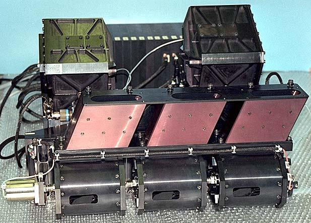
4 Performance data: Modular Optoelectronic Scanner MOS-IRS (orbit: altitude 817 km; 10:45 AM equator crossing time, descending node, sun synchroneous polar) Parameter MOS-A MOS-B MOS-C Spectral range [nm] No. of channels Centre wavelengths [nm] 756.7; 760.6; 763.5; ; 443; 485; 520; 570; 615; 650; 685; 750; 815; 870; 945; Spectral FWHM [nm] Swath width [km] No. of pixels Pixel size x * y [km2] 4.9 x x x 0.74 Measuring range Lmin...Lmax [µwcm-2nm-1sr-1] Accuracy L/L at Lmin [%] Dynamic range [bit]
5 5


6 6
7 Nadir Position objective Sun Calibration Position sun direction tube with baffles fixed housing rotating drum diffuser nadir direction Dark Position 7
8 2. In-orbit calibrations Internal lamps: Relative calibration of all pixels and checking the opto-electronical components of the spectrometer using two lamps at different levels Sun calibration: Absolut and relative end to end calibration of all pixels using Spectralon diffusers in front of each instrument, 40 incidence angle, 50 viewing angle Ground target based (vicarious) calibration: Relative end to end calibration of 60x60 pixels of water vapour unaffected channels over Algerian Great Eastern Erg (GEE) without atmospheric correction Moon calibration: Checking the calibration relations between the channels in the O 2 absorption band and between MOS-A and MOS-B without atmospheric O 2 absorption effects 8
9 Internal lamp calibration 9
10 sun MOS - IRS; sun calibration optimal timing for SUN-CAL at limited recording time (51sec) n a d ir 1 schematic sequence of response data, for channel B9, pixel sec 120 sec 123 sec 51 sec/record S1 S2 S3 S4 S5 1 position ,1 43,0 40,0 37,0 32,0 1 start diffuser rotation terminator 1 tthe sequence of response date is different for each channel and pixel 1 time / sec 1 sun incidence angle / 10


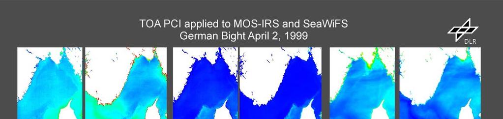
11 SeaWiFS SeaWiFS Great Eastern Erg, MOS, SeaWiFS, and MOS MOS 11

12 MOS - IRS - P3: In - Orbit - calibration, channel b01 (408nm), correction for T=15,00 C after failure of cooling 1,15 Launch of MOS-IRS-P3, Change of vignetting, 2/1999 Failure sun and lamp cal, 9/2000 Failure of TE cooling, 11/2002 1,10 1,05 ratio 1,00 0,95 0,90 0, b01_vic b01_sun b01_int 12
13 MOS - IRS - P3: In - Orbit - calibration, channel b08 (685nm), correction for T=15,00 C after failure of cooling 1,15 Launch of MOS-IRS-P3, Change of vignetting, 2/1999 Failure sun and lamp cal, 9/2000 Failure of TE cooling, 11/2002 1,10 1,05 ratio 1,00 0,95 0,90 0, b08_vic b08_sun b08_int 13
14 MOS - IRS - P3: In - Orbit - calibration, channel b13 (1010nm), correction for T=15,00 C after failure of cooling 1,15 1,10 Launch of MOS-IRS-P3, Change of vignetting, 2/1999 Failure sun and lamp cal, 9/2000 1,05 ratio 1,00 0,95 Failure of TE cooling, 11/2002 0,90 0, b13_vic b13_sun b13_int 14
15 Relative spectral sensitivity S(λ,T) of the CCD-line L172 versus wavelength λ and temperature T 1,3 Relative spectral sensitivity 1,200-1,300 1,100-1,200 1,000-1,100 0,900-1,000 0,800-0, ,2 1,1 1,0 0,9 0,8 relative spectral sensitivity (4,5 C = 1,0). wavelength/nm ,5 0,7 24,6 4,5-4,0 temperature / C 15

16 Relative change of MOS - IRS components during mission time 1,2 1,1 relative change 1,0 0,9 state: total responsivity optics transmission CCD surface evapor. sun diff. ( ) 0,8 0, nm 16
 5 5 5 4 4 4 Channel 2 3 2 1 Channel 3")
17 MOS Moon Calibration 27/08/ MOS-B Channel 9 (original) Wavelength [nm] Mean Moon Reflectance Scatterplots of MOS-A channels Radiances in µw/cm² nm sr MOS-A Channel 1 (original) Channel Channel Channel Channel Channel Channel 1 17
18 5 MOS-B Scatterplots of different records and same channels Channel 1 vs Channel Channel 9 vs Channel 9 Scatterplots of geometrically matched original and filtered MOS-A and MOS-B at 750nm Scatterplot MOS-B vs MOS-A at 750nm unfiltered Theoretically derived filterfunction and quasi-optimal rectangular filterfunction Scatterplot MOS-B vs MOS-A at 750nm filtered Radiance MOS-A µw/cm² nm sr Filterweight Radiance MOS-A µw/cm² nm sr Radiance MOS-B µw/cm² nm sr Pixelnumber Radiance MOS-B µw/cm² nm sr 18
19 3. Inter-comparisons with other missions Surface reflectance of ground target Great Eastern Erg (GEE): derived from MOS and SeaWiFS data between 1997 and 2001 Derived geophysical products: chlorophyll concentration, sediment concentration and aerosol optical thickness derived from MOS and SeaWiFS data over different oceans and coastal zones 19
20 MOS and SeaWiFS sensor description (MOS only SeaWiFS-like bands) MOS-IRS / DLR SeaWiFS / NASA Instrument spectral bands (for MOS only SeaWiFS-like bands) B nm nm B nm nm B nm nm B nm nm B nm nm B nm nm B nm nm B nm nm Mission characteristics Swath width 200 km (14.0 ) Swath width 2800 km (53.8 ) 820 km sun synchroneous orbit 705 km sun synchroneous orbit 0.52 x 0.52 km² pixel size 1.1 x 1.1 km² pixel size 10:30 AM equator crossing, descending 12:20 AM equator crossing, descending 24 days revisit time 1 day revisit time 20
21 Relative variations of recalibrated MOS and SeaWiFS data of Great Eastern Erg test site for two selected channels 0,10 MOS-IRS-P3: Vicarious calibration, channel b02 (443nm) 1,4 SeaWiFS: Normalized surface reflectance, ch. 02 (443nm) 0,05 1,2 vic-fit 0,00 ratio 1,0-0,05 0,8-0, , ,10 MOS-IRS-P3: Vicarious calibration, channel b05 (570nm) 1,4 SeaWiFS: Normalized surface reflectance, ch. 05 (555nm) 0,05 1,2 vic-fit 0,00 ratio 1,0-0,05 0,8-0,10 0,
22 Spectral reflectance of Sahara sand derived from MOS, SeaWiFS and EGO 0,7 MOS-IRS-P3: Surface reflectance of Great Eastern Erg for the eight SeaWiFS-like channels (mean value) 0,7 SeaWiFS: Surface reflectance of Great Eastern Erg for the eight SeaWiFS channels (mean value) 0, ,6 surface reflectance 0,5 0,4 0,3 0, surface reflectance 0,5 0,4 0,3 0, , ,1 0, wavelength/nm 0, wavelength/nm 0,7 Reflectance of Sahara sand (measured by Despan/JRC/Ispra with EGO (European Goniometer), solar zenith angle: 27, solar azimuth angle: 0 0,6 rho_s 0,5 0,4 0,3 view. z/ rel. az/ ,2 0,1 0, wavelength/nm 22


23 23
24 4. Conclusions The precise lab calibration, adjustment and the comprehensive knowledge of the instruments behaviour under different environmental conditions was of utmost importance for the 8 years successful mission in orbit Using different methods of in-orbit calibration afforded to get continously recalibration data in spite of some critical events such as the failure of power supply for lamp and sun calibration and of detector TE cooling This also gives the possibility of discrimination and identification of different sources and reasons for changes in the calibration data Accuracy of about 1...2% for the recalibration data is achievable Inter-comparisons between MOS and SeaWiFS showed a relative good consistency but gave also the chance for finding out some obscurities 24
Calibration of Ocean Colour Sensors
 Dr. A. Neumann German Aerospace Centre DLR Remote Sensing Technology Institute Marine Remote Sensing What is Calibration, why do we need it? Sensor Components Definition of Terms Calibration Standards
GCOM-C/SGLI and its Lunar Calibration
 GCOM-C/SGLI and its Lunar Calibration Lunar Calibration Workshop December 1-4, 2014 JAXA/GCOM Proj. Yoshihiko Okamura (okamura.yoshihiko@jaxa.jp) 1. Overview of GCOM-C satellite and SGLI (1) Global Change
A Comparative Study and Intercalibration Between OSMI and SeaWiFS
 A Comparative Study and Intercalibration Between OSMI and SeaWiFS KOMPSAT-1 Bryan A. Franz NASA SIMBIOS Project Yongseung Kim Korea Aerospace Research Institute ORBVIEW-2 Abstract Since 1996, following
GCOM-C SGLI calibration and characterization. Hiroshi Murakami JAXA/EORC Satellite instrument pre- and post-launch calibration
 GCOM-C SGLI calibration and characterization Hiroshi Murakami JAXA/EORC Satellite instrument pre- and post-launch calibration 1 1. SGLI sensor system and onboard calibration system Target: Improvement
Chapter 4 Nadir looking UV measurement. Part-I: Theory and algorithm
 Chapter 4 Nadir looking UV measurement. Part-I: Theory and algorithm -Aerosol and tropospheric ozone retrieval method using continuous UV spectra- Atmospheric composition measurements from satellites are
SCIAMACHY REFLECTANCE AND POLARISATION VALIDATION: SCIAMACHY VERSUS POLDER
 SCIAMACHY REFLECTANCE AND POLARISATION VALIDATION: SCIAMACHY VERSUS POLDER L. G. Tilstra (1), P. Stammes (1) (1) Royal Netherlands Meteorological Institute (KNMI), P.O. Box 201, 3730 AE de Bilt, The Netherlands
Calibration of MERIS on ENVISAT Status at End of 2002
 Calibration of MERIS on ENVISAT Status at End of 2002 Bourg L. a, Delwart S. b, Huot J-P. b a ACRI-ST, 260 route du Pin Montard, BP 234, 06904 Sophia-Antipolis Cedex, France b ESA/ESTEC, P.O. Box 299,
OCEAN COLOUR MONITOR ON-BOARD OCEANSAT-2
 OCEAN COLOUR MONITOR ON-BOARD OCEANSAT-2 Rangnath R Navalgund Space Applications Centre Indian Space Research Organisation Ahmedabad-380015, INDIA OCEANSAT-2 2 MISSION OCEANSAT-2 2 is a global mission
GMES: calibration of remote sensing datasets
 GMES: calibration of remote sensing datasets Jeremy Morley Dept. Geomatic Engineering jmorley@ge.ucl.ac.uk December 2006 Outline Role of calibration & validation in remote sensing Types of calibration
GOSAT mission schedule
 GOSAT mission schedule 29 21 12 1 2 3 4 6 7 8 9 1 11 12 1 2 214 1 2 3 ~ Jan. 23 Launch Initial Checkout Initial function check Initial Cal. and Val. Mission life Normal observation operation Extra Operati
Verification of Sciamachy s Reflectance over the Sahara J.R. Acarreta and P. Stammes
 Verification of Sciamachy s Reflectance over the Sahara J.R. Acarreta and P. Stammes Royal Netherlands Meteorological Institute P.O. Box 201, 3730 AE de Bilt, The Netherlands Email Address: acarreta@knmi.nl,
HICO Science Mission Overview
 HICO Science Mission Overview Michael R. Corson* and Curtiss O. Davis** * Naval Research Laboratory Washington, DC corson@nrl.navy.mil ** College of Oceanic and Atmospheric Sciences Oregon State University
MODIS On-orbit Calibration Methodologies
 MODIS On-orbit Calibration Methodologies Jack Xiong and Bill Barnes NASA/GSFC, Greenbelt, MD 20771, USA University of Maryland, Baltimore County, Baltimore MD, 21250, USA (Support provided by entire MCST
Vicarious calibration of GLI by global datasets. Calibration 5th Group Hiroshi Murakami (JAXA EORC)
") Vicarious calibration of GLI by global datasets Calibration 5th Group Hiroshi Murakami (JAXA EORC) ADEOS-2 PI workshop March 2004 1 0. Contents 1. Background 2. Operation flow 3. Results 4. Temporal change
Vicarious calibration of GLI by global datasets Calibration 5th Group Hiroshi Murakami (JAXA EORC) ADEOS-2 PI workshop March 2004 1 0. Contents 1. Background 2. Operation flow 3. Results 4. Temporal change
NIR Solar Reference Spectrum Algorithm for the Orbiting Carbon Observatory (OCO)
") NIR Solar Reference Spectrum Algorithm for the Orbiting Carbon Observatory (OCO) Hartmut Bösch and Geoffrey Toon Jet Propulsion Laboratory, California Institute of Technology OCO Mission Global, space-based
NIR Solar Reference Spectrum Algorithm for the Orbiting Carbon Observatory (OCO) Hartmut Bösch and Geoffrey Toon Jet Propulsion Laboratory, California Institute of Technology OCO Mission Global, space-based
Angelika Dehn Rob Koopman 10 Years GOME on ERS-2 Workshop
 Angelika Dehn (ADehn@serco.it), Rob Koopman (Rob.Koopman@esa.int), Overview I. ERS-2 Mission History 1. Mission Plan Highlights 2. GOME Special Operations II. GOME-1 Engineering Performance 1. Routine
Copernicus Sentinel Earth Observation Hyperspectral Instruments - short overview on calibration
 Copernicus Sentinel Earth Observation Hyperspectral Instruments - short overview on calibration Berit Ahlers, Matthias Erdmann (ESA ESTEC); Pepijn Veefkind (KNMI); Marcel Dobber (EUMETSAT) 25 th Calcon,
GOME-2 COMMISSIONING RESULTS: GEOPHYSICAL VALIDATION OF LEVEL 1 PRODUCTS
 GOME-2 COMMISSIONING RESULTS: GEOPHYSICAL VALIDATION OF LEVEL 1 PRODUCTS Rosemary Munro (1), Rüdiger Lang (1), Yakov Livschitz (1), Michael Eisinger (2), Abelardo Pérez-Albiñana (1) (1) EUMETSAT, Darmstadt,
HICO Calibration and Atmospheric Correction
 HICO Calibration and Atmospheric Correction Curtiss O. Davis College of Earth Ocean and Atmospheric Sciences Oregon State University, Corvallis, OR, USA 97331 cdavis@coas.oregonstate.edu Oregon State Introduction
MERIS US Workshop. Instrument Characterization Overview. Steven Delwart
 MERIS US Workshop Instrument Characterization Overview Steven Delwart Presentation Overview On-Ground Characterisation 1. Diffuser characterisation 2. Polarization sensitivity 3. Optical Transmission 4.
Long-Term Time Series of Water Vapour Total Columns from GOME, SCIAMACHY and GOME-2
 Graphics: ESA Graphics: ESA Graphics: ESA Long-Term Time Series of Water Vapour Total Columns from GOME, SCIAMACHY and GOME-2 S. Noël, S. Mieruch, H. Bovensmann, J. P. Burrows Institute of Environmental
Spectral surface albedo derived from GOME-2/Metop measurements
 Spectral surface albedo derived from GOME-2/Metop measurements Bringfried Pflug* a, Diego Loyola b a DLR, Remote Sensing Technology Institute, Rutherfordstr. 2, 12489 Berlin, Germany; b DLR, Remote Sensing
(A)ATSR and SLSTR VIS/SWIR Channels Calibration
ATSR and SLSTR VIS/SWIR Channels Calibration") (A)ATSR and SLSTR VIS/SWIR Channels Calibration Dave Smith & Mireya Etxaluze 2017 RAL Space 1 ATSR Series 1991-2000 ATSR-1 1995-2008 ATSR-2 2002-2012- AATSR 2 SLSTR Series 2016 Sentinel 3A 2018 Sentinel
(A)ATSR and SLSTR VIS/SWIR Channels Calibration Dave Smith & Mireya Etxaluze 2017 RAL Space 1 ATSR Series 1991-2000 ATSR-1 1995-2008 ATSR-2 2002-2012- AATSR 2 SLSTR Series 2016 Sentinel 3A 2018 Sentinel
Sentinel-3 Sea and Land Surface Temperature Radiometer (SLSTR) Mireya Etxaluze (STFC RAL Space)
 Mireya Etxaluze (STFC RAL Space)") Sentinel-3 Sea and Land Surface Temperature Radiometer (SLSTR) Mireya Etxaluze (STFC RAL Space) RAL Space Radiometry Group Dave Smith Mireya Etxaluze, Ed Polehampton, Caroline Cox, Tim Nightingale, Dan
Sentinel-3 Sea and Land Surface Temperature Radiometer (SLSTR) Mireya Etxaluze (STFC RAL Space) RAL Space Radiometry Group Dave Smith Mireya Etxaluze, Ed Polehampton, Caroline Cox, Tim Nightingale, Dan
Cross-calibration of Geostationary Satellite Visible-channel Imagers Using the Moon as a Common Reference
 Cross-calibration of Geostationary Satellite Visible-channel Imagers Using the Moon as a Common Reference Thomas C. Stone U.S. Geological Survey, Flagstaff AZ, USA 27 30 August, 2012 Motivation The archives
In-Orbit Vicarious Calibration for Ocean Color and Aerosol Products
 In-Orbit Vicarious Calibration for Ocean Color and Aerosol Products Menghua Wang NOAA National Environmental Satellite, Data, and Information Service Office of Research and Applications E/RA3, Room 12,
MERIS SMILE EFFECT CHARACTERISATION AND CORRECTION DOCUMENT. document title/ titre du document. prepared by/préparé par MERIS ESL
 DOCUMENT document title/ titre du document MERIS SMILE EFFECT CHARACTERISATION AND CORRECTION prepared by/préparé par MERIS ESL reference/réference issue/édition 2 revision/révision 0 date of issue/date
Lectures 7 and 8: 14, 16 Oct Sea Surface Temperature
 Lectures 7 and 8: 14, 16 Oct 2008 Sea Surface Temperature References: Martin, S., 2004, An Introduction to Ocean Remote Sensing, Cambridge University Press, 454 pp. Chapter 7. Robinson, I. S., 2004, Measuring
SOLSPEC MEASUREMENT OF THE SOLAR ABSOLUTE SPECTRAL IRRADIANCE FROM 165 to 2900 nm ON BOARD THE INTERNATIONAL SPACE STATION
 SOLSPEC MEASUREMENT OF THE SOLAR ABSOLUTE SPECTRAL IRRADIANCE FROM 165 to 2900 nm ON BOARD THE INTERNATIONAL SPACE STATION G. Thuillier 1, D. Bolsee 2, T. Foujols 1 1 LATMOS-CNRS, France 2 Institut d Aéronomie
CALIBRATION AND VALIDATION OF ENVISAT MERIS PART 1: VICARIOUS CALIBRATION AT RAIL ROAD VALLEY PLAYA (NV)
") CALIBRATION AND VALIDATION OF ENVISAT MERIS PART 1: VICARIOUS CALIBRATION AT RAIL ROAD VALLEY PLAYA (NV) Mathias Kneubühler (1), Michael Schaepman (1), Kurt Thome (2), Fréderic Baret (3), Andreas Müller
CALIBRATION AND VALIDATION OF ENVISAT MERIS PART 1: VICARIOUS CALIBRATION AT RAIL ROAD VALLEY PLAYA (NV) Mathias Kneubühler (1), Michael Schaepman (1), Kurt Thome (2), Fréderic Baret (3), Andreas Müller
The EarthCARE mission: An active view on aerosols, clouds and radiation
 The EarthCARE mission: An active view on aerosols, clouds and radiation T. Wehr, P. Ingmann, T. Fehr Heraklion, Crete, Greece 08/06/2015 EarthCARE is ESA s sixths Earth Explorer Mission and will be implemented
In-flight Spectral Calibration of MERIS/OLCI. Jürgen Fischer, Rene Preusker, Rasmus Lindstrot Institute for Space Science Free University Berlin
 In-flight Spectral Calibration of MERIS/OLCI Jürgen Fischer, Rene Preusker, Rasmus Lindstrot Institute for Space Science Free University Berlin 1 MERIS Instrument 2 MERIS Instrument Concept 3 MERIS Operation
NASA's Plankton, Aerosol, Cloud, ocean Ecosystem (PACE) mission update
 mission update") NASA's Plankton, Aerosol, Cloud, ocean Ecosystem (PACE) mission update Antonio Mannino1, Jeremy Werdell1, Brian Cairns2 NASA GSFC1 and GISS2 Acknowledgments: PACE Team https://pace.gsfc.nasa.gov 1 Outline
NASA's Plankton, Aerosol, Cloud, ocean Ecosystem (PACE) mission update Antonio Mannino1, Jeremy Werdell1, Brian Cairns2 NASA GSFC1 and GISS2 Acknowledgments: PACE Team https://pace.gsfc.nasa.gov 1 Outline
Pre-Launch Characterization and In-orbit Calibration of GCOM-C/SGLI
 Pre-Launch Characterization and In-orbit Calibration of GCOM-C/SGLI IGARSS 2018 July 26, 2018 Japan Aerospace Exploration Agency Yoshihiko Okamura T. Hashiguchi, T. Urabe, K. Tanaka (JAXA) J Yoshida, T
Final Report. Study on Radiometric Requirements for Hyperspectral Applications. Prepared for ESTEC, Noordwijk, The Netherlands
 Sira Electro-Optics Limited, South Hill Chislehurst, Kent, BR7 5EH, England Telephone: +44 (0)20 8467 2636 Fax: +44 (0)20 8467 6515 Email: info@siraeo.co.uk Website: www.siraeo.co.uk Registered in England
Atmospheric Lidar The Atmospheric Lidar (ATLID) is a high-spectral resolution lidar and will be the first of its type to be flown in space.
 is a high-spectral resolution lidar and will be the first of its type to be flown in space.") www.esa.int EarthCARE mission instruments ESA s EarthCARE satellite payload comprises four instruments: the Atmospheric Lidar, the Cloud Profiling Radar, the Multi-Spectral Imager and the Broad-Band Radiometer.
www.esa.int EarthCARE mission instruments ESA s EarthCARE satellite payload comprises four instruments: the Atmospheric Lidar, the Cloud Profiling Radar, the Multi-Spectral Imager and the Broad-Band Radiometer.
New GOME/ERS-2 Level-1 Product In-Flight Calibration and Degradation Monitoring
 www.dlr.de Chart 1 New GOME/ERS-2 Level-1 Product In-Flight Calibration and Degradation Monitoring M. Coldewey-Egbers 1, B. Aberle 1, S. Slijkhuis 1, D. Loyola 1, and A. Dehn 2 1 DLR-IMF and 2 ESA-ESRIN
MODIS Reflective Solar Bands Calibration Algorithm and On-orbit Performance
 MODIS Reflective Solar Bands Calibration Algorithm and On-orbit Performance X. (Jack) Xiong* a, J. Sun a, J. Esposito a, B. Guenther b, and W. Barnes c a Science Systems and Applications, Inc., 10210 Greenbelt
In-flight Evaluation of the SPOT-6 Radiometric Calibration based on Acquisitions over Natural Targets and Automated in-situ Measurements
 In-flight Evaluation of the SPOT-6 Radiometric Calibration based on Acquisitions over Natural Targets and Automated in-situ Measurements Philippe GAMET, Bertrand FOUGNIE, Sophie LACHERADE (CNES), Mathieu
MERIS, A-MODIS, SeaWiFS, AATSR and PARASOL over the Salar de Uyuni March 2006 MAVT 2006 Marc Bouvet, ESA/ESTEC
 MERIS, A-MODIS, SeaWiFS, AATSR and PARASOL over the Salar de Uyuni Plan of the presentation 1. Introduction : from absolute vicarious calibration to radiometric intercomparison 2. Intercomparison at TOA
Summary. Introduction. Rationale for morning observations The morning atmosphere in N spring. Conclusions. The PFS experiment Physics of PFS data
 Martian morning atmosphere during Northern spring from the Planetary Fourier Spectrometer (PFS) measurements D. Grassi(1), C. Fiorenza (1,2), N.I. Ignatiev(3,1), L.V. Zasova(3,1), A. Maturilli(5,1,4),
Status of Libya-4 Activities - RAL
 Status of Libya-4 Activities - RAL Dr David L Smith Preparation for reprocessing AATSR Long term drift correction LUT version 2.09 implemented in reprocessing V3.00 available based on revised BRF modelling
Centre for Electronic Imaging
 Centre for Electronic Imaging Calibration plans for the Soft X-ray Imager s CCDs on SMILE Open University: George Randall, Matthew Soman, David Hall, Andrew Holland, Ross Burgon, Jonathan Keelan, Thomas
Thermal And Near infrared Sensor for carbon Observation (TANSO) On board the Greenhouse gases Observing SATellite (GOSAT) Research Announcement
 On board the Greenhouse gases Observing SATellite (GOSAT) Research Announcement") Thermal And Near infrared Sensor for carbon Observation (TANSO) On board the Greenhouse gases Observing SATellite (GOSAT) Research Announcement Appendix A Outlines of GOSAT and TANSO Sensor GOSAT (Greenhouse
Thermal And Near infrared Sensor for carbon Observation (TANSO) On board the Greenhouse gases Observing SATellite (GOSAT) Research Announcement Appendix A Outlines of GOSAT and TANSO Sensor GOSAT (Greenhouse
C M E M S O c e a n C o l o u r S a t e l l i t e P r o d u c t s
 Implemented by C M E M S O c e a n C o l o u r S a t e l l i t e P r o d u c t s This slideshow gives an overview of the CMEMS Ocean Colour Satellite Products Marine LEVEL1 For Beginners- Slides have been
GOSAT update. June Prepared by JAXA EORC Presented by David Crisp
 CEOS AC-VC GOSAT update June Prepared by JAXA EORC Presented by David Crisp GOSAT & GOSAT-2 Organization ORGANIZATION GOSAT is the joint project of JAXA, MOE (Ministry of the Environment) and NIES (National
FIRST VALIDATION OF MERIS AEROSOL PRODUCT OVER LAND
 ABSTRACT FIRST VALIDATION OF MERIS AEROSOL PRODUCT OVER LAND Didier Ramon (1), Richard Santer (2), Jerôme Vidot (2) 1. HYGEOS, 191 rue N. Appert, 59650 Villeneuve d Ascq, France, dr@hygeos.com 2. Université
The VENμS mission: Earth Observation with High Spatial and Temporal Resolution Capabilities
 Ben Gurion University The VENμS mission: Earth Observation with High Spatial and Temporal Resolution Capabilities G. Dedieu 1, O. Hagolle 2, A. Karnieli 3, S. Cherchali 2 P. Ferrier 2 and Y. Yaniv 4 1
Thermal Design and Analysis of the BroadBand Radiometer. Oliver Poyntz-Wright (Rutherford Appleton Laboratory, United Kingdom)
") 255 Appendix T Thermal Design and Analysis of the BroadBand Radiometer Oliver Poyntz-Wright (Rutherford Appleton Laboratory, United Kingdom) 256 Thermal Design and Analysis of the BroadBand Radiometer
255 Appendix T Thermal Design and Analysis of the BroadBand Radiometer Oliver Poyntz-Wright (Rutherford Appleton Laboratory, United Kingdom) 256 Thermal Design and Analysis of the BroadBand Radiometer
CNES WGCV-36 Report Cal/Val Activities
 CEOS WGCV Meeting 13-17th May 2013, Shangai, China CNES WGCV-36 Report Cal/Val Activities Bertrand Fougnie, Sophie Lachérade, Denis Jouglet, Eric Péquignot, Aimé Meygret, Patrice Henry CNES 1 Summary Pleiades
Comparison of Results Between the Miniature FASat-Bravo Ozone Mapping Detector (OMAD) and NASA s Total Ozone Mapping Spectrometer (TOMS)
 and NASA s Total Ozone Mapping Spectrometer (TOMS)") SSC08-VI-7 Comparison of Results Between the Miniature FASat-Bravo Ozone Mapping Detector (OMAD) and NASA s Total Ozone Mapping Spectrometer (TOMS) Juan A. Fernandez-Saldivar, Craig I. Underwood Surrey
SSC08-VI-7 Comparison of Results Between the Miniature FASat-Bravo Ozone Mapping Detector (OMAD) and NASA s Total Ozone Mapping Spectrometer (TOMS) Juan A. Fernandez-Saldivar, Craig I. Underwood Surrey
Status of VIIRS Reflective Solar Bands On-orbit Calibration and Performance
 EOS Status of VIIRS Reflective Solar Bands On-orbit Calibration and Performance X. Xiong 1, J. Fulbright 2, N. Lei 2, J. Sun 2, Z. Wang 2, and J. McIntire 2 1. NASA/GSFC, Greenbelt, MD 20771, USA 2. Sigma
Satellite Position Determination of LEO Spacecraft
 Satellite Position Determination of LEO Spacecraft S.C.Rathnakara ISRO Satellite Centre 5 th September, 2007 International Committee on Global Navigation Satellite Systems(ICG) Things to follow Brief background
Improvement of Himawari-8 observation data quality
 Improvement of Himawari-8 observation data quality 3 July 2017 Meteorological Satellite Center Japan Meteorological Agency The Japan Meteorological Agency (JMA) plans to modify its Himawari-8 ground processing
Status of CNES Cal/Val Activities
 GSICS Executive Panel Meeting 16-17th May 2014, Guangzhou, China Status of CNES Cal/Val Activities Patrice Henry CNES 1 Summary Overview of CNES Cal/Val Activities Summary Re-Calibration Activities POLDER(s)/PARASOL
HICO OSU Website and Data Products
 HICO OSU Website and Data Products Curtiss O. Davis College of Earth Ocean and Atmospheric Sciences Oregon State University, Corvallis, OR, USA 97331 cdavis@coas.oregonstate.edu Oregon State Introduction
GSICS UV Sub-Group Activities
 GSICS UV Sub-Group Activities Rosemary Munro with contributions from NOAA, NASA and GRWG UV Subgroup Participants, in particular L. Flynn 1 CEOS Atmospheric Composition Virtual Constellation Meeting (AC-VC)
Tracking On-orbit Radiometric Accuracy and Stability of Suomi NPP VIIRS using Extended Low Latitude SNOs
 Tracking On-orbit Radiometric Accuracy and Stability of Suomi NPP VIIRS using Extended Low Latitude SNOs Sirish Uprety a Changyong Cao b Slawomir Blonski c Xi Shao c Frank Padula d a CIRA, Colorado State
Hyperspectral Atmospheric Correction
 Hyperspectral Atmospheric Correction Bo-Cai Gao June 2015 Remote Sensing Division Naval Research Laboratory, Washington, DC USA BACKGROUND The concept of imaging spectroscopy, or hyperspectral imaging,
MERIS SURFACE PRESSURE AND CLOUD FLAG: PRESENT STATUS AND IMPROVEMENTS
 ABSTRACT MERIS SURFACE PRESSURE AND CLOUD FLAG: PRESENT STATUS AND IMPROVEMENTS D. Ramon (1), R. Santer (2), P. Dubuisson (2) (1) HYGEOS, 191 rue N. Appert, 59650 Villeneuve d Ascq, FRANCE, dr@hygeos.com
Thermal And Near infrared Sensor for carbon Observation (TANSO) onboard the Greenhouse gases Observing SATellite (GOSAT) Research Announcement
 onboard the Greenhouse gases Observing SATellite (GOSAT) Research Announcement") Thermal And Near infrared Sensor for carbon Observation (TANSO) onboard the Greenhouse gases Observing SATellite (GOSAT) Research Announcement Appendix C Operation Policies of GOSAT and Basic Observation
Thermal And Near infrared Sensor for carbon Observation (TANSO) onboard the Greenhouse gases Observing SATellite (GOSAT) Research Announcement Appendix C Operation Policies of GOSAT and Basic Observation
Land Surface Temperature Measurements From the Split Window Channels of the NOAA 7 Advanced Very High Resolution Radiometer John C.
 Land Surface Temperature Measurements From the Split Window Channels of the NOAA 7 Advanced Very High Resolution Radiometer John C. Price Published in the Journal of Geophysical Research, 1984 Presented
Estimation of ocean contribution at the MODIS near-infrared wavelengths along the east coast of the U.S.: Two case studies
 GEOPHYSICAL RESEARCH LETTERS, VOL. 32, L13606, doi:10.1029/2005gl022917, 2005 Estimation of ocean contribution at the MODIS near-infrared wavelengths along the east coast of the U.S.: Two case studies
Impacts of Atmospheric Corrections on Algal Bloom Detection Techniques
 1 Impacts of Atmospheric Corrections on Algal Bloom Detection Techniques Ruhul Amin, Alex Gilerson, Jing Zhou, Barry Gross, Fred Moshary and Sam Ahmed Optical Remote Sensing Laboratory, the City College
Yi Liu TanSat Science Team
 12th International Workshop on Greenhouse Gas Measurements from Space The Pre Launch Status of TanSat Mission Yi Liu TanSat Science Team Institute of Atmospheric Physics, Chinese Academy of Sciences 9
HYPERSPECTRAL IMAGING
 1 HYPERSPECTRAL IMAGING Lecture 9 Multispectral Vs. Hyperspectral 2 The term hyperspectral usually refers to an instrument whose spectral bands are constrained to the region of solar illumination, i.e.,
The EarthCARE mission: An active view on aerosols, clouds and radiation
 The EarthCARE mission: An active view on aerosols, clouds and radiation T. Wehr, T. Fehr, P. Ingmann, J. v. Bismarck ESRIN, Frascati, Italy 20/10/2015 EARTH Clouds, Aerosols and Radiation Explorer EarthCARE
AIRS Level 1b. Tom Pagano AIRS Project Project Manager. Hartmut Aumann AIRS Project Scientist
 AIRS Level 1b Tom Pagano AIRS Project Project Manager Hartmut Aumann AIRS Project Scientist Jet Propulsion Laboratory California Institute of Technology and Ken Overoye AIRS Calibration System Engineer
DOAS UV/VIS minor trace gases from SCIAMACHY
 DOAS UV/VIS minor trace gases from SCIAMACHY Rüdiger de Beek, Andreas Richter, John P. Burrows Inst. of Environm. Physics, University of Bremen, Otto-Hahn-Allee 1, D-28359 Bremen, Germany, Email: ruediger.de_beek@iup.physik.uni-bremen.de
Illumination, Radiometry, and a (Very Brief) Introduction to the Physics of Remote Sensing!
 Introduction to the Physics of Remote Sensing!") Illumination, Radiometry, and a (Very Brief) Introduction to the Physics of Remote Sensing! Course Philosophy" Rendering! Computer graphics! Estimation! Computer vision! Robot vision" Remote sensing! lhm
Illumination, Radiometry, and a (Very Brief) Introduction to the Physics of Remote Sensing! Course Philosophy" Rendering! Computer graphics! Estimation! Computer vision! Robot vision" Remote sensing! lhm
CALCULATION OF UNDERSAMPLING CORRECTION SPECTRA FOR DOAS SPECTRAL FITTING
 CALCULATION OF UNDERSAMPLING CORRECTION SPECTRA FOR DOAS SPECTRAL FITTING Sander Slijkhuis 1, Albrecht von Bargen 1, Werner Thomas 1, and Kelly Chance 2 1 Deutsches Zentrum für Luft- und Raumfahrt e.v.,
SOFIE Instrument Model and Performance Comparison
 Utah State University DigitalCommons@USU Space Dynamics Lab Publications Space Dynamics Lab 9-7-2006 SOFIE Instrument Model and Performance Comparison Scott Hansen Andrew Shumway Chad Fish Jim Peterson
VERIFICATION OF MERIS LEVEL 2 PRODUCTS: CLOUD TOP PRESSURE AND CLOUD OPTICAL THICKNESS
 VERIFICATION OF MERIS LEVEL 2 PRODUCTS: CLOUD TOP PRESSURE AND CLOUD OPTICAL THICKNESS Rene Preusker, Peter Albert and Juergen Fischer 17th December 2002 Freie Universitaet Berlin Institut fuer Weltraumwissenschaften
Full solar rotations observed by the SOLAR payload on the ISS in December 2012 and June 2013.
 Full solar rotations observed by the SOLAR payload on the ISS in December 2012 and June 2013. C. Muller and the SOLAR operation and science teams, SOLAR instruments: SOVIM Total sun irradiance measurement
Comparison of Results Between the Miniature FASat-Bravo Ozone Mapping Detector (OMAD) and NASA s Total Ozone Mapping Spectrometer (TOMS)
 and NASA s Total Ozone Mapping Spectrometer (TOMS)") Comparison of Results Between the Miniature FASat-Bravo Ozone Mapping Detector (OMAD) and NASA s Total Ozone Mapping Spectrometer (TOMS) Juan A. Fernandez-Saldivar, Craig I. Underwood Surrey Space Centre,
Comparison of Results Between the Miniature FASat-Bravo Ozone Mapping Detector (OMAD) and NASA s Total Ozone Mapping Spectrometer (TOMS) Juan A. Fernandez-Saldivar, Craig I. Underwood Surrey Space Centre,
Keiji Imaoka Earth Observation Research Center (EORC) Japan Aerospace Exploration Agency (JAXA) GSICS/GRWG Meeting Darmstadt, Germany March 25, 2014
 Japan Aerospace Exploration Agency (JAXA) GSICS/GRWG Meeting Darmstadt, Germany March 25, 2014") Keiji Imaoka Earth Observation Research Center (EORC) Japan Aerospace Exploration Agency (JAXA) GSICS/GRWG Meeting Darmstadt, Germany March 25, 2014 JAXA Satellite Projects Late 1990s 2000s 2003 (JAXA
Keiji Imaoka Earth Observation Research Center (EORC) Japan Aerospace Exploration Agency (JAXA) GSICS/GRWG Meeting Darmstadt, Germany March 25, 2014 JAXA Satellite Projects Late 1990s 2000s 2003 (JAXA
Status of GOCI-II Development
 Status of GOCI-II Development Seongick CHO On the behalf of Dr. YoungJe Park, Director of KOSC Korea Ocean Satellite Center (KOSC) Korea Institute of Ocean Science & Technology (KIOST) IOCS Meeting 2015,
Integral in Orbit* The Integral satellite was launched on 17 October 2002, at
 * The Integral satellite was launched on 17 October 2002, at 4:41 Universal Time, from Baikonur aboard a Proton rocket. The flawless launch marked the culmination of more than a decade of work for the
HARP Assessment of Uncertainty
 HARP Assessment of Uncertainty The HIAPER Airborne Radiation Package (HARP) was designed to produce accurate measurements of actinic flux and irradiance. The Atmospheric Radiation Group (ARG) at the University
Sumi-NPP OMPS Calibration and Characterization from Early Orbit Images
 Sumi-NPP OMPS Calibration and Characterization from Early Orbit Images *C. Pan 1, F. Weng 2, X. Wu 2, L. Flynn 2, G. Jaross 3 and S. Janz 4 * 1 ESSIC, University of Maryland, College Park, MD 20740 2 NOAA
The Copernicus Sentinel-5 Mission: Daily Global Data for Air Quality, Climate and Stratospheric Ozone Applications
 SENTINEL-5 The Copernicus Sentinel-5 Mission: Daily Global Data for Air Quality, Climate and Stratospheric Ozone Applications Yasjka Meijer RHEA for ESA, Noordwijk, NL 15/04/2016 Co-Authors: Jörg Langen,
IR sounder small satellite for polar orbit weather measurements
 IR sounder small satellite for polar orbit weather measurements Sara Lampen, Sonny Yi, Jared Lang, Caleb Lampen, Adam Vore, David Warren, Eric Herman The Aerospace Corporation John J. Pereira National
Status of S-NPP VIIRS Solar and Lunar Calibration
 Status of S-NPP VIIRS Solar and Lunar Calibration X. Xiong 1, N. Lei 2, J. Fulbright 2, and Z. Wang 2 1 NASA Goddard Space Flight Center, Greenbelt, MD 20771, USA 2 Science Systems and Applications Inc.,
THE METOP SECOND GENERATION 3MI MISSION
 THE METOP SECOND GENERATION 3MI MISSION Ilias Manolis, Jean-Loup Bézy, Maurizio Betto, Hubert Barré and Graeme Mason European Space Agency, ESTEC, Keplerlaan 1, 2200 AG Noordwijk ZH, The Netherlands Abstract
Biological Oceanography by Remote Sensing. M.A. Srokosz
 Biological Oceanography by Remote Sensing M.A. Srokosz in Encyclopedia of Analytical Chemistry R.A. Meyers (Ed.) pp. 8506 8533 John Wiley & Sons Ltd, Chichester, 2000 BIOLOGICAL OCEANOGRAPHY BY REMOTE
MODIS and VIIRS Reflective Solar Bands Calibration, Performance, and Inter-comparison
 EOS MODIS and VIIRS Reflective Solar Bands Calibration, Performance, and Inter-comparison Jack Xiong 1, Aisheng Wu 1, and Changyong Cao 2 1. NASA/GSFC; 2. NOAA/STAR Other Contributors: NASA MCST and VCST
Remote Sensing How we know what we know A Brief Tour
 Remote Sensing How we know what we know A Brief Tour Dr. Erik Richard Dr. Jerald Harder LASP Richard 1 Remote Sensing The measurement of physical variables (usually light or sound) from outside of a medium
Simulated Radiances for OMI
 Simulated Radiances for OMI document: KNMI-OMI-2000-004 version: 1.0 date: 11 February 2000 author: J.P. Veefkind approved: G.H.J. van den Oord checked: J. de Haan Index 0. Abstract 1. Introduction 2.
Sentinel-2 and Sentinel-3 absolute calibration monitoring. C. Desjardins & V. Lonjou CNES
 Sentinel-2 and Sentinel-3 absolute calibration monitoring C. Desjardins & V. Lonjou CNES Radiometric S2A Calibration RRQI, 28 January Workshop, 2016, 30-31/08/2017 CNES SUMMARY CALCON Aug 22-25 2017 VICARIOUS
In-flight Calibration of Satellite Ocean-Colour Sensors
 In-flight Calibration of Satellite Ocean-Colour Sensors Reports of the International Ocean-Colour Coordinating Group REPORT NUMBER XX 1 Reports and Monographs of the International Ocean-Colour Coordinating
Traceability to the GIRO and ROLO
 EOS Traceability to the GIRO and ROLO Jack Xiong (NASA) In collaboration with Tom Stone (USGS) Sébastien Wagner, Tim Hewison (EUMETSAT) Sophie Lachérade, Bertrand Fougnie (CNES) GSICS Lunar Calibration
Appendix D. Thermal Modelling of Luna 27 Landing Site. Hannah Rana Vito Laneve Philipp Hager Thierry Tirolien (ESA/ESTEC, The Netherlands)
") 47 Appendix D Thermal Modelling of Luna 27 Landing Site Hannah Rana Vito Laneve Philipp Hager Thierry Tirolien (ESA/ESTEC, The Netherlands) 48 Thermal Modelling of Luna 27 Landing Site Abstract Luna 27,
47 Appendix D Thermal Modelling of Luna 27 Landing Site Hannah Rana Vito Laneve Philipp Hager Thierry Tirolien (ESA/ESTEC, The Netherlands) 48 Thermal Modelling of Luna 27 Landing Site Abstract Luna 27,
Blackbody radiation. Main Laws. Brightness temperature. 1. Concepts of a blackbody and thermodynamical equilibrium.
 Lecture 4 lackbody radiation. Main Laws. rightness temperature. Objectives: 1. Concepts of a blackbody, thermodynamical equilibrium, and local thermodynamical equilibrium.. Main laws: lackbody emission:
The Ozone Mapping and Profiler Suite (OMPS): From SNPP to JPSS-1
: From SNPP to JPSS-1") The Ozone Mapping and Profiler Suite (OMPS): From SNPP to JPSS-1 *C. Pan 1 and F. Weng 2 Curtsey of BATC Aerosol Index * 1 ESSIC, University of Maryland, College Park, MD 20740; 2 NOAA NESDIS/STAR, College
The Ozone Mapping and Profiler Suite (OMPS): From SNPP to JPSS-1 *C. Pan 1 and F. Weng 2 Curtsey of BATC Aerosol Index * 1 ESSIC, University of Maryland, College Park, MD 20740; 2 NOAA NESDIS/STAR, College
RADIOMETRIC INTERCALIBRATION OF MOMS AND SPOT BY VICARIOUS METHOD
 RADIOMETRIC INTERCALIBRATION OF MOMS AND SPOT BY VICARIOUS METHOD M. Schroeder, R. Müller, P. Reinartz German Aerospace Center, DLR Remote Sensing Technology Institute, Image Science P.O. Box 11 16 82234
PLANET-C: Venus Climate Orbiter mission -Updates- Takehiko Satoh (Kumamoto Univ / JAXA) George Hashimoto (Kobe Univ) PLANET-C team
 George Hashimoto (Kobe Univ) PLANET-C team") PLANET-C: Venus Climate Orbiter mission -Updates- Takehiko Satoh (Kumamoto Univ / JAXA) George Hashimoto (Kobe Univ) PLANET-C team Venus Climate Orbiter JAXA s 24th science spacecraft dedicated to the
PLANET-C: Venus Climate Orbiter mission -Updates- Takehiko Satoh (Kumamoto Univ / JAXA) George Hashimoto (Kobe Univ) PLANET-C team Venus Climate Orbiter JAXA s 24th science spacecraft dedicated to the
SCIAMACHY IN-FLIGHT CALIBRATION
 SCIAMACHY IN-FLIGHT CALIBRATION Ralph Snel SRON Netherlands Institute for Space Research Sorbonnelaan 2, 3584 CA Utrecht, the Netherlands Email: R.Snel@sron.nl ABSTRACT The options for SCIAMACHY in-flight
624 SNPP VIIRS Solar Diffuser BRDF Degradation Trend Changes in Early Evan Haas* and Frank De Luccia The Aerospace Corporation, El Segundo CA
 624 SNPP VIIRS Solar Diffuser BRDF Degradation Trend Changes in Early 2014 1. INTRODUCTION Evan Haas* and Frank De Luccia The Aerospace Corporation, El Segundo CA The Visible Infrared Imaging Radiometer
IAA. 1.9: Aerosol-UA - Satellite remote sensing of aerosols in the Earth atmosphere
 IAA. 1.9: Aerosol-UA - Satellite remote sensing of aerosols in the Earth atmosphere Ya. Yatskiv (1), O. Degtyaryov (3), G. Milinevsky (1,2), I. Syniavskyi (1), A. Bovchaliuk (1), Yu. Ivanov (1), M. Sosonkin
Relation of atmospheric humidity and cloud properties to surface-near temperatures derived from GOME satellite observations
 Relation of atmospheric humidity and cloud properties to surface-near temperatures derived from GOME satellite observations Thomas Wagner 1, Steffen Beirle 1, Tim Deutschmann 2, Michael Grzegorski 2, Ulrich