UK-DMC 2 and Deimos-1, New DMC Sensors for Agricultural Monitoring. Owen Hawkins DMC International Imaging Ltd
|
|
|
- Abigail Carter
- 5 years ago
- Views:
Transcription


1 UK-DMC 2 and Deimos-1, New DMC Sensors for Agricultural Monitoring Owen Hawkins DMC International Imaging Ltd


2 Full Spectrum Satellite Solutions Design Manufacture Assembly, Integration & Test Launch Services Ground Segment & Operations Processing & Supply


3 The DMC Concept A Unique International Partnership Combining National Objectives, Humanitarian Aid and Commerce The Coordinator The Consortium The Constellation Applications; Commercial, Government and Humanitarian

 Private Owners Beijing-1 (BLMIT corp.")
 (Launched) N2 (2010) NX")
4 Constellation Status Five spacecraft in first generation with 32m GSD Second generation available NOW with 22m GSD Third Generation available 2010 with 2.5m GSD Governments owners AlSAT-1 (Algeria) NigeriaSat-1 (Nigeria) NigeriaSat-2 NigeriaSat-X BILSAT-1 (Turkey) Private Owners Beijing-1 (BLMIT corp.) UK-DMC (DMCii) UK-DMC-2 (DMCii) Deimos-1 (Deimos Imaging) NigeriaSat-1 ALSAT-1 UK-DMC Beijing-1 BILSAT + Deimos-DMC UK-DMC2 (Launched) (Launched) N2 (2010) NX (2010) Next generations


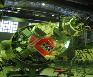
5 UK-DMC-2 and Deimos-1 Launched! Launched from Baikour 1 st Image 6 days after Launch

6 Second Generation DMC The second generation DMC satellites have been redesigned to give a 22m GSD imager with the same large (640km swath) Changes in the optics, electronics, AOCS and operational procedures are expected to improve data quality significantly Removal of Horizontal Striping (Improvement of Sensor Electronics - Success Improvement of MTF and Dynamic Range - Success

7 Comparison with old DMC s Geometric OLD Used gravity gradient boom on first generation imagers, caused some geometric problems NEW Fully agile system, improved momentum wheels to reduce micro-vibration
8 Top-Level Calibration Approach Pre Launch Calibration Post Launch Calibration Sensor Characterisation Laboratory Measurements Generate Coefficients Early Absolute Surface Measurements Relative Measurements Absolute Measurements Fixed Temperature, Variable Gains Pre-Launch Coefficients Absolute Measurement with Short Time Separation Pacific at Night Gold Standard Variable Temperature, Fixed Gains Thermal Model Updated Coefficients Antarctic Ice Sheet Updated Coefficients Sensor Specific Variables Sensor Model Updated Coefficients
9 Practical Implementation Three ongoing elements Early Absolute Calibration Prior to separation (phasing) of launched satellites Near Concurrent acquisitions over calibration site Absolute calibration (ongoing) Uses a single satellite Gold standard More acquisitions (more confidence) Lower costs as single satellite Transfer calibration (ongoing) Uses Dome-C in Antarctica to transfer from a few detectors to whole array Cross-calibration (ongoing) Intersections over Dome-C (half an image overlap 320km) time separation of 30 minutes to one hour with stable atmosphere


10 Transfer Calibration Transfer uses stable site in Antarctica at Dome-C For each absolute acquisition all nine pixels used to generate nine radiances Use mean value of nine pixels Repeat for other absolute acquisitions Get range of radiance values (one for each absolute image), since single white image used for transfer this is a measure of uncertainty Dome-C base and surface disturbance from Nigeriasat-1
11 Cross-Calibration Cross-calibration steps include, Selection of best cloud free pair Correction for solar zenith differences Correction for variability, if the pair is at the edge of the distribution it is corrected to the mean for the 19 image pairs Calculation of new TOA radiances for UK-DMC-1 based on TOA radiances from Nigeriasat-1 Recalculation of calibration gain values
12 Calibration Aims Current Absolute calibration is <7% for new satellites By the start of 2010, the target of <5% (industry standard) will be reached The relative calibration between the satellites will be <1% as per the DMCii standard

13 Early Results from New Satellites Launch 29 th July UK-DMC-2 and Deimos-1 1 st Images 1 week after launch Deimos-1 Image, Spain Deimos Imaging

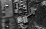
14 Early Results from New Satellites Launch 29 th July UK-DMC-2 and Deimos-1 1 st Images 1 week after launch UK-DMC-2 Image, Texas DMCii

15 Early Results from New Satellites Launch 29 th July UK-DMC-2 and Deimos-1 1 st Images 1 week after launch Application of prelaunch calibration coefficients gives good results Sensor outgassing and stabilisation will modify response over next 6 months Intensive relative flat field calibration during critical stage Monthly relative and biannual absolute calibration thereafter UK-DMC-2 Image Detail, Dallas Fort Worth Airport DMCii

16 Green band UK DMC 1
17 Green band UK DMC 2

18 Red band UK DMC 1

19 Red band UK DMC 2

20 NIR band UK DMC 1

21 NIR band UK DMC 2

22 22m/32m Resolution Coverage of Parts of Africa As Of Mid-October Collected by Beijing-1, UK-DMC-1, UK-DMC-2, NigeriaSat-1, Deimos-1

23 European Coverage 2 Satellites Only DAY 0
24 European Coverage 2 Satellites Only DAY 1
25 European Coverage 2 Satellites Only DAY 2
26 European Coverage 2 Satellites Only DAY 3
27 European Coverage 2 Satellites Only DAY 4
28 European Coverage 2 Satellites Only DAY 5


29 Monitoring Europe; A Constellation Success Complete coverage in three months Delivered 38 countries 5.8 million km 2 Individual acquisition windows Individual projections <5% cloud 32 metre gsd
30 Other Projects Using Rapid Revisit Continued Precision Agriculture in USA, Europe, South America and Asia National land cover mapping campaigns in major countries in Europe and Australasia providing annual or better coverages Continued forestry monitoring in Amazon and Congo Basins and Indonesia Background global mapping project


31 New Sensors NigeriaSat-X Built by Nigerian engineers in Surrey Similar design to Deimos-1 22m GSD Very Large Area Imager To Launch Q3 2010


32 New Sensors NigeriaSat-2 Carries 2.5m Pan and 5m Multispectral Imagers, with a Wide Swath Imager also on Board Very Agile Platform To Launch Q3 2010
33 Thank You
Challenges for the operational assimilation of satellite image data in agrometeorological models
 Challenges for the operational assimilation of satellite image data in agrometeorological models Mark Danson Centre for Environmental Systems Research, University of Salford, UK 0 Objectives The main objective
The DEIMOS Earth Observation System and the PanGeo Alliance. Contribution to CSCDA Data WareHouse 2. Fabrizio Pirondini CEO, Elecnor Deimos Imaging
 The DEIMOS Earth Observation System and the PanGeo Alliance Contribution to CSCDA Data WareHouse 2 Fabrizio Pirondini CEO, Elecnor Deimos Imaging Copernicus Space Component Data Access Workshop ESRIN,
UrtheCast s High Resolution Imagery, HD Video and Synthetic Aperture Radar from Space for Smart Earth Observations Dr. Rao S.
 UrtheCast s High Resolution Imagery, HD Video and Synthetic Aperture Radar from Space for Smart Earth Observations Dr. Rao S. Ramayanam Vice President Middle East, Africa and South Asia Geo Smart Asia
Deimos-2 Post-launch radiometric calibration
 Deimos-2 Post-launch radiometric Jorge Gil Alfredo Romo Cristina Moclán Fabrizio Pirondini (Elecnor Deimos Imaging) ELECNOR DEIMOS, Spain JACIE 2015 14th Annual Civil Commercial Imagery Evaluation Workshop
Subsystems & Payloads
 Subsystems & Payloads Surrey Satellite Technology is the world s leading small satellite manufacturer We are pioneering space company Surrey Satellite Technology world leader in designing, manufacturing,
Comparison of Results Between the Miniature FASat-Bravo Ozone Mapping Detector (OMAD) and NASA s Total Ozone Mapping Spectrometer (TOMS)
 and NASA s Total Ozone Mapping Spectrometer (TOMS)") Comparison of Results Between the Miniature FASat-Bravo Ozone Mapping Detector (OMAD) and NASA s Total Ozone Mapping Spectrometer (TOMS) Juan A. Fernandez-Saldivar, Craig I. Underwood Surrey Space Centre,
Comparison of Results Between the Miniature FASat-Bravo Ozone Mapping Detector (OMAD) and NASA s Total Ozone Mapping Spectrometer (TOMS) Juan A. Fernandez-Saldivar, Craig I. Underwood Surrey Space Centre,
Status of the Sentinel-5 Precursor Presented by C. Zehner S5p, S4, and S5 Missions Manager - ESA
 Status of the Sentinel-5 Precursor Presented by C. Zehner S5p, S4, and S5 Missions Manager - ESA European response to global needs: to manage the environment, to mitigate the effects of climate change
In-flight Evaluation of the SPOT-6 Radiometric Calibration based on Acquisitions over Natural Targets and Automated in-situ Measurements
 In-flight Evaluation of the SPOT-6 Radiometric Calibration based on Acquisitions over Natural Targets and Automated in-situ Measurements Philippe GAMET, Bertrand FOUGNIE, Sophie LACHERADE (CNES), Mathieu
Meteosat Third Generation (MTG): Lightning Imager and its products Jochen Grandell
: Lightning Imager and its products Jochen Grandell") 1 Go to View menu and click on Slide Master to update this footer. Include DM reference, version number and date Meteosat Third Generation (MTG): Lightning Imager and its products Jochen Grandell Topics
1 Go to View menu and click on Slide Master to update this footer. Include DM reference, version number and date Meteosat Third Generation (MTG): Lightning Imager and its products Jochen Grandell Topics
GEOG Lecture 8. Orbits, scale and trade-offs
 Environmental Remote Sensing GEOG 2021 Lecture 8 Orbits, scale and trade-offs Orbits revisit Orbits geostationary (36 000 km altitude) polar orbiting (200-1000 km altitude) Orbits revisit Orbits geostationary
sentinel-2 COLOUR VISION FOR COPERNICUS
 sentinel-2 COLOUR VISION FOR COPERNICUS SATELLITES TO SERVE By providing a set of key information services for a wide range of practical applications, Europe s Copernicus programme is providing a step
Uncertainty of satellite-based solar resource data
 Uncertainty of satellite-based solar resource data Marcel Suri and Tomas Cebecauer GeoModel Solar, Slovakia 4th PV Performance Modelling and Monitoring Workshop, Köln, Germany 22-23 October 2015 About
The VENμS mission: Earth Observation with High Spatial and Temporal Resolution Capabilities
 Ben Gurion University The VENμS mission: Earth Observation with High Spatial and Temporal Resolution Capabilities G. Dedieu 1, O. Hagolle 2, A. Karnieli 3, S. Cherchali 2 P. Ferrier 2 and Y. Yaniv 4 1
The International Charter Space and Major Disasters is further strengthening its contribution to disaster management worldwide.
 28 September 2012 Issue 3 The International Charter Space and Major Disasters is further strengthening its contribution to disaster management worldwide. Building on a decade of success in making satellite
VIIRS SDR Cal/Val: S-NPP Update and JPSS-1 Preparations
 VIIRS SDR Cal/Val: S-NPP Update and JPSS-1 Preparations VIIRS SDR Cal/Val Posters: Xi Shao Zhuo Wang Slawomir Blonski ESSIC/CICS, University of Maryland, College Park NOAA/NESDIS/STAR Affiliate Spectral
TRUTHS-Lite: A Microsatellite Based Climate Benchmark Mission
 IAA-B10-0404 TRUTHS-Lite: A Microsatellite Based Climate Benchmark Mission Craig Underwood 1, Nigel Fox 2, Javier Gorroño 2 1 Surrey Space Centre, University of Surrey, Guildford, Surrey, GU2 7XH, UK 2
Status of CNES Cal/Val Activities
 GSICS Executive Panel Meeting 16-17th May 2014, Guangzhou, China Status of CNES Cal/Val Activities Patrice Henry CNES 1 Summary Overview of CNES Cal/Val Activities Summary Re-Calibration Activities POLDER(s)/PARASOL
Sentinel-1 Mission Status
 Sentinel-1 Mission Status Pierre Potin, Sentinel-1 Mission Manager, ESA Luca Martino, Technical Support Engineer, ESA... and the Sentinel-1 operations team PSTG SAR Coordination Working Group 14 December
MODIS On-orbit Calibration Methodologies
 MODIS On-orbit Calibration Methodologies Jack Xiong and Bill Barnes NASA/GSFC, Greenbelt, MD 20771, USA University of Maryland, Baltimore County, Baltimore MD, 21250, USA (Support provided by entire MCST
- satellite orbits. Further Reading: Chapter 04 of the text book. Outline. - satellite sensor measurements
 (1 of 12) Further Reading: Chapter 04 of the text book Outline - satellite orbits - satellite sensor measurements - remote sensing of land, atmosphere and oceans (2 of 12) Introduction Remote Sensing:
Long-Term Time Series of Water Vapour Total Columns from GOME, SCIAMACHY and GOME-2
 Graphics: ESA Graphics: ESA Graphics: ESA Long-Term Time Series of Water Vapour Total Columns from GOME, SCIAMACHY and GOME-2 S. Noël, S. Mieruch, H. Bovensmann, J. P. Burrows Institute of Environmental
A Concept of Nanosatellite Small Fleet for Earth Observation
 A Concept of Nanosatellite Small Fleet for Earth Observation Prof. Janusz Narkiewicz jnark@meil.pw.edu.pl Sebastian Topczewski stopczewski@meil.pw.edu.pl Mateusz Sochacki msochacki@meil.pw.edu.pl 10-11
Space Telescopes Asteroid Mining Space Manufacturing. Wefunder.com/SpaceFab
 Space Telescopes Asteroid Mining Space Manufacturing Wefunder.com/SpaceFab Business Road Map Cost efficient high value space telescopes Unique business model Deployable optics technology Asteroid mining
A Regional Microsatellite Constellation with Electric Propulsion In Support of Tuscan Agriculture
 Berlin, 20 th - 24 th 2015 University of Pisa 10 th IAA Symposium on Small Satellites for Earth Observation Student Conference A Regional Microsatellite Constellation with Electric Propulsion In Support
Sea-level change: A scientific and societal challenge for the 21 st century John Church International GNSS Service Workshop, Sydney, Feb 11, 2016
 Sea-level change: A scientific and societal challenge for the 21 st century John Church International GNSS Service Workshop, Sydney, Feb 11, 2016 OCEANS AND ATMOSPHERE NATIONAL RESEARCH FLAGSHIP Our coastal
Sentinel-1 Mission Status
 Sentinel-1 Mission Status Pierre Potin, Sentinel-1 Mission Manager 5TH GEOGLAM RAPP Workshop 16-17 May 2017, ESRIN Sentinel-1: Copernicus radar imaging mission for ocean, land, emergency Part of the Copernicus
Intelligent City Management
 Intelligent City Management Based on Land Cover Feature Changes Detected by Satellite Imagery Twenty First Century Aerospace Technology (21AT) www.21at.com.cn Geospatial World Forum 2016 Outline 01 Introduction
GCOM-C SGLI calibration and characterization. Hiroshi Murakami JAXA/EORC Satellite instrument pre- and post-launch calibration
 GCOM-C SGLI calibration and characterization Hiroshi Murakami JAXA/EORC Satellite instrument pre- and post-launch calibration 1 1. SGLI sensor system and onboard calibration system Target: Improvement
The Landsat Program and its Products: Global Land Surveys. Garik Gutman LCLUC Program Manager NASA Headquarters Washington, DC
 The Landsat Program and its Products: Global Land Surveys Garik Gutman LCLUC Program Manager NASA Headquarters Washington, DC 1 Land-Cover/Land-Use Change Program LCLUC is an interdisciplinary scientific
Sentinel-3 Sea and Land Surface Temperature Radiometer (SLSTR) Mireya Etxaluze (STFC RAL Space)
 Mireya Etxaluze (STFC RAL Space)") Sentinel-3 Sea and Land Surface Temperature Radiometer (SLSTR) Mireya Etxaluze (STFC RAL Space) RAL Space Radiometry Group Dave Smith Mireya Etxaluze, Ed Polehampton, Caroline Cox, Tim Nightingale, Dan
Sentinel-3 Sea and Land Surface Temperature Radiometer (SLSTR) Mireya Etxaluze (STFC RAL Space) RAL Space Radiometry Group Dave Smith Mireya Etxaluze, Ed Polehampton, Caroline Cox, Tim Nightingale, Dan
Improvement of Himawari-8 observation data quality
 Improvement of Himawari-8 observation data quality 3 July 2017 Meteorological Satellite Center Japan Meteorological Agency The Japan Meteorological Agency (JMA) plans to modify its Himawari-8 ground processing
Global Solar Dataset for PV Prospecting. Gwendalyn Bender Vaisala, Solar Offering Manager for 3TIER Assessment Services
 Global Solar Dataset for PV Prospecting Gwendalyn Bender Vaisala, Solar Offering Manager for 3TIER Assessment Services Vaisala is Your Weather Expert! We have been helping industries manage the impact
Physical Model to Describe the PARASOL Radiometric Trending. Definition, Adjustment, and Validation
 Physical Model to Describe the PARASOL Radiometric Trending Definition, Adjustment, and Validation Bertrand Fougnie CNES CALCON 13 Summary The PARASOL instrument & mission Evidences a of radiometric drift
Polar Multi-Sensor Aerosol Product: User Requirements
 Polar Multi-Sensor Aerosol Product: User Requirements Doc.No. Issue : : EUM/TSS/REQ/13/688040 v2 EUMETSAT EUMETSAT Allee 1, D-64295 Darmstadt, Germany Tel: +49 6151 807-7 Fax: +49 6151 807 555 Telex: 419
SPACE TECHNOLOGY INSTITUTE, VNREDSat-1 and DATA PROVIDER NODE (DPN) REPORT
 REPORT") 4th Joint Project Team Meeting for Sentinel Asia STEP3 (JPTM2017) 8-9 March 2017 SPACE TECHNOLOGY INSTITUTE, VNREDSat-1 and DATA PROVIDER NODE (DPN) REPORT www.sti.vast.ac.vn CONTENT 1. Overview of Space
4th Joint Project Team Meeting for Sentinel Asia STEP3 (JPTM2017) 8-9 March 2017 SPACE TECHNOLOGY INSTITUTE, VNREDSat-1 and DATA PROVIDER NODE (DPN) REPORT www.sti.vast.ac.vn CONTENT 1. Overview of Space
Imaging the whole Earth every day. Josh Alban VP, Business Development
 Imaging the whole Earth every day Josh Alban VP, Business Development josh@planet.com Planet Labs helps you detect and act on change by imaging the whole Earth everyday. Challenges Limited Coverage Low
CNES WGCV-36 Report Cal/Val Activities
 CEOS WGCV Meeting 13-17th May 2013, Shangai, China CNES WGCV-36 Report Cal/Val Activities Bertrand Fougnie, Sophie Lachérade, Denis Jouglet, Eric Péquignot, Aimé Meygret, Patrice Henry CNES 1 Summary Pleiades
Copernicus Today and Tomorrow GEO Week Group on Earth Observation Geneva, 16 January 2014 The Copernicus Space Infrastructure
 Copernicus Today and Tomorrow GEO Week Group on Earth Observation Geneva, 16 January 2014 The Copernicus Space Infrastructure Thomas Beer, Policy Coordinator, Copernicus Space Office, ESA-ESRIN, Frascati
MERIS SMILE EFFECT CHARACTERISATION AND CORRECTION DOCUMENT. document title/ titre du document. prepared by/préparé par MERIS ESL
 DOCUMENT document title/ titre du document MERIS SMILE EFFECT CHARACTERISATION AND CORRECTION prepared by/préparé par MERIS ESL reference/réference issue/édition 2 revision/révision 0 date of issue/date
CALIBRATION over the Moon An introduction to «POLO»
 CALIBRATION over the Moon An introduction to «POLO» Sophie Lachérade Bertrand Fougnie Aimé Meygret CEOS - IVOS 25, Frascati, 19-21 march 2013 Introduction It has been demonstrated that the Moon is a very
The Ozone Mapping and Profiler Suite (OMPS): From SNPP to JPSS-1
: From SNPP to JPSS-1") The Ozone Mapping and Profiler Suite (OMPS): From SNPP to JPSS-1 *C. Pan 1 and F. Weng 2 Curtsey of BATC Aerosol Index * 1 ESSIC, University of Maryland, College Park, MD 20740; 2 NOAA NESDIS/STAR, College
The Ozone Mapping and Profiler Suite (OMPS): From SNPP to JPSS-1 *C. Pan 1 and F. Weng 2 Curtsey of BATC Aerosol Index * 1 ESSIC, University of Maryland, College Park, MD 20740; 2 NOAA NESDIS/STAR, College
AN INTERNATIONAL SOLAR IRRADIANCE DATA INGEST SYSTEM FOR FORECASTING SOLAR POWER AND AGRICULTURAL CROP YIELDS
 AN INTERNATIONAL SOLAR IRRADIANCE DATA INGEST SYSTEM FOR FORECASTING SOLAR POWER AND AGRICULTURAL CROP YIELDS James Hall JHTech PO Box 877 Divide, CO 80814 Email: jameshall@jhtech.com Jeffrey Hall JHTech
Space research. Horizon Work Programme. "Countdown to Horizon 2020 Space" Earth Observation topics. Brussels, 12 December 2013
 Space research Horizon 2020 - Work Programme "Countdown to Horizon 2020 Space" Earth Observation topics Brussels, 12 December 2013 richard.gilmore@ec.europa.eu Table of contents FP/Copernicus - general
Tracking On-orbit Radiometric Accuracy and Stability of Suomi NPP VIIRS using Extended Low Latitude SNOs
 Tracking On-orbit Radiometric Accuracy and Stability of Suomi NPP VIIRS using Extended Low Latitude SNOs Sirish Uprety a Changyong Cao b Slawomir Blonski c Xi Shao c Frank Padula d a CIRA, Colorado State
COPERNICUS SPACE DATA OFFER FOR PUBLIC AUTHORITIES DISTRIBUTED BY ESA
 COPERNICUS SPACE DATA OFFER FOR PUBLIC AUTHORITIES DISTRIBUTED BY ESA The Copernicus Space Component Data Access (CSC-DA) service - financed by the EU and operated by ESA - grants National Public Authorities
Status report on current and future satellite systems by EUMETSAT Presented to CGMS-44, Plenary session, agenda item D.1
 Status report on current and future satellite systems by EUMETSAT Presented to CGMS-44, Plenary session, agenda item D.1 CGMS-44-EUMETSAT-WP-19.ppt, version 1 (# 859110), 8 June 2016 MISSION PLANNING YEAR...
Landsat-8 Operational Land Imager (OLI) Initial On-Orbit Performance
 Initial On-Orbit Performance") Landsat-8 Operational Land Imager (OLI) Initial On-Orbit Performance Geir Kvaran, Ed Knight, Khurrum Ansari, Kenton Lee, Brent Canova, Brian Donley Ball Aerospace & Technologies Corp. Hugh Kieffer Celestial
Landsat-8 Operational Land Imager (OLI) Initial On-Orbit Performance Geir Kvaran, Ed Knight, Khurrum Ansari, Kenton Lee, Brent Canova, Brian Donley Ball Aerospace & Technologies Corp. Hugh Kieffer Celestial
Vertical distribution of dust aerosols from 5 years of CALIPSO observations
 Vertical distribution of dust aerosols from 5 years of CALIPSO observations, Alain Chédin, Sophie Peyridieu Laboratoire de Météorologie Dynamique CNRS/IPSL, Ecole Polytechnique christoforos.tsamalis@lmd.polytechnique.fr
Figure 1. View of ALSAT-2A spacecraft
 ALSAT-2A TRANSFER AND FIRST YEAR OPERATIONS M. Kameche (1), A.H. Gicquel (2), D. Joalland (3) (1) CTS/ASAL, 1 Avenue de la Palestine, BP 13, Arzew 31200 Oran, Algérie, email:mo_kameche@netcourrier.com
WORLD S CHOICE FOR GEO IMAGING. Advanced Baseline Imager (ABI)
") WORLD S CHOICE FOR GEO IMAGING Advanced Baseline Imager (ABI) MARKET-LEADING EXPERTISE DELIVERS BEST-IN-CLASS WEATHER IMAGING In cases of extreme weather such as hurricanes, typhoons, blizzards and tornadoes,
WORLD S CHOICE FOR GEO IMAGING Advanced Baseline Imager (ABI) MARKET-LEADING EXPERTISE DELIVERS BEST-IN-CLASS WEATHER IMAGING In cases of extreme weather such as hurricanes, typhoons, blizzards and tornadoes,
PLANET-C: Venus Climate Orbiter mission -Updates- Takehiko Satoh (Kumamoto Univ / JAXA) George Hashimoto (Kobe Univ) PLANET-C team
 George Hashimoto (Kobe Univ) PLANET-C team") PLANET-C: Venus Climate Orbiter mission -Updates- Takehiko Satoh (Kumamoto Univ / JAXA) George Hashimoto (Kobe Univ) PLANET-C team Venus Climate Orbiter JAXA s 24th science spacecraft dedicated to the
PLANET-C: Venus Climate Orbiter mission -Updates- Takehiko Satoh (Kumamoto Univ / JAXA) George Hashimoto (Kobe Univ) PLANET-C team Venus Climate Orbiter JAXA s 24th science spacecraft dedicated to the
5th Annual CubeSat Developers' Workshop April 2008 Cal Poly San Luis Obispo, California
 5th Annual CubeSat Developers' Workshop 9-11 April 2008 Cal Poly San Luis Obispo, California From UNISAT to ubesatsat UNICube Chantal CAPPELLETTI, Fabrizio PAOLILLO, Francesco GUARDUCCI, Luigi RIDOLFI
Commercialisation. Lessons learned from Dutch weather market
 Commercialisation Lessons learned from Dutch weather market Where information comes together weather traffic public transport Weather, traffic and public transport. Daily actual information that influences
Acta Astronautica 71 (2012) Contents lists available at SciVerse ScienceDirect. Acta Astronautica
 Contents lists available at SciVerse ScienceDirect. Acta Astronautica") Acta Astronautica 71 (2012) 119 128 Contents lists available at SciVerse ScienceDirect Acta Astronautica journal homepage: www.elsevier.com/locate/actaastro Recent design and utilization trends of small
Acta Astronautica 71 (2012) 119 128 Contents lists available at SciVerse ScienceDirect Acta Astronautica journal homepage: www.elsevier.com/locate/actaastro Recent design and utilization trends of small
Atmosphere-Space Interactions Monitor (ASIM) on the International Space Station
 on the International Space Station") Atmosphere-Space Interactions Monitor (ASIM) on the International Space Station Torsten Neubert Ib Lundgaard Rasmussen National Space Institute Overall Objective Thunderstorms and their relation to atmospheric
Atmosphere-Space Interactions Monitor (ASIM) on the International Space Station Torsten Neubert Ib Lundgaard Rasmussen National Space Institute Overall Objective Thunderstorms and their relation to atmospheric
MONTHLY OPERATIONS REPORT
 MONTHLY OPERATIONS REPORT MOR#027 Reporting period from 16-Feb-2016 to 15-Mar-2016 Reference: PROBA-V_D5_MOR-027_2016-03_v1.0 Author(s): Dennis Clarijs, Sindy Sterckx, Alex Geboers, Erwin Wolters Version:
STATUS OF JAPANESE METEOROLOGICAL SATELLITES AND RECENT ACTIVITIES OF MSC
 STATUS OF JAPANESE METEOROLOGICAL SATELLITES AND RECENT ACTIVITIES OF MSC Daisaku Uesawa Meteorological Satellite Center, Japan Meteorological Agency Abstract MTSAT-1R is the current operational Japanese
EUMETSAT. A global operational satellite agency at the heart of Europe. Presentation for the Spanish Industry Day Madrid, 15 March 2012
 EUMETSAT A global operational satellite agency at the heart of Europe Presentation for the Spanish Industry Day Madrid, Angiolo Rolli EUMETSAT Director of Administration EUMETSAT objectives The primary
MSG system over view
 MSG system over view 1 Introduction METEOSAT SECOND GENERATION Overview 2 MSG Missions and Services 3 The SEVIRI Instrument 4 The MSG Ground Segment 5 SAF Network 6 Conclusions METEOSAT SECOND GENERATION
Global Monitoring for Environment and Security (GMES)
") Global Monitoring for Environment and Security (GMES) Satellite Earth Observation for the Emergency Services Dr Nick Veck Presentation to the G-STEP Launch Univ. of Leicester 19 th June 2009 Contents of
Global Monitoring for Environment and Security (GMES) Satellite Earth Observation for the Emergency Services Dr Nick Veck Presentation to the G-STEP Launch Univ. of Leicester 19 th June 2009 Contents of
C O P E R N I C U S F O R G I P R O F E S S I O N A L S
 C O P E R N I C U S F O R G I P R O F E S S I O N A L S Downstream Applications MALTA 2017-06-26 Pascal Lory, EUROGI EU EU EU www.copernicus.eu S c o p e Identifying urban housing density: Stella Ofori-Ampofo,
Land Surface Temperature Measurements From the Split Window Channels of the NOAA 7 Advanced Very High Resolution Radiometer John C.
 Land Surface Temperature Measurements From the Split Window Channels of the NOAA 7 Advanced Very High Resolution Radiometer John C. Price Published in the Journal of Geophysical Research, 1984 Presented
Module 7, Lesson 2 In the eye of the storm
 Module 7, Lesson 2 In the eye of the storm October 21, 1998 A tropical storm is brewing in the Atlantic Ocean. It began as a tropical wave a few weeks earlier, off the coast of western Africa. Today it
Emergency Management Service (EMS) mapping
 mapping") GMES Emergency Management Service (EMS) mapping Frédéric BASTIDE GMES unit, European Commission UN-SPIDER Expert Meeting: "Crowdsource Mapping for Disaster Risk Management and Emergency Response" 3-5 December,
GMES Emergency Management Service (EMS) mapping Frédéric BASTIDE GMES unit, European Commission UN-SPIDER Expert Meeting: "Crowdsource Mapping for Disaster Risk Management and Emergency Response" 3-5 December,
UK Contribution to the European CORINE Land Cover
 Centre for Landscape andwww.le.ac.uk/clcr Climate Research CENTRE FOR Landscape and Climate Research UK Contribution to the European CORINE Land Cover Dr Beth Cole Corine Coordination of Information on
Solar Insolation and Earth Radiation Budget Measurements
 Week 13: November 19-23 Solar Insolation and Earth Radiation Budget Measurements Topics: 1. Daily solar insolation calculations 2. Orbital variations effect on insolation 3. Total solar irradiance measurements
David Antoine on behalf of the OCAPI science team
 European prospects for a geostationary ocean color sensor: the ocean color advanced permanent imager (OCAPI) David Antoine on behalf of the OCAPI science team Curtin University, Remote Sensing & Satellite
Jay Lawrimore NOAA National Climatic Data Center 9 October 2013
 Jay Lawrimore NOAA National Climatic Data Center 9 October 2013 Daily data GHCN-Daily as the GSN Archive Monthly data GHCN-Monthly and CLIMAT messages International Surface Temperature Initiative Global
Thermal Design and Analysis of the BroadBand Radiometer. Oliver Poyntz-Wright (Rutherford Appleton Laboratory, United Kingdom)
") 255 Appendix T Thermal Design and Analysis of the BroadBand Radiometer Oliver Poyntz-Wright (Rutherford Appleton Laboratory, United Kingdom) 256 Thermal Design and Analysis of the BroadBand Radiometer
255 Appendix T Thermal Design and Analysis of the BroadBand Radiometer Oliver Poyntz-Wright (Rutherford Appleton Laboratory, United Kingdom) 256 Thermal Design and Analysis of the BroadBand Radiometer
MSG/SEVIRI AND METOP/AVHRR SNOW EXTENT PRODUCTS IN H-SAF
 MSG/SEVIRI AND METOP/AVHRR SNOW EXTENT PRODUCTS IN H-SAF Niilo Siljamo, Otto Hyvärinen Finnish Meteorological Institute, Erik Palménin aukio 1, Helsinki, Finland Abstract Weather and meteorological processes
Simulated Radiances for OMI
 Simulated Radiances for OMI document: KNMI-OMI-2000-004 version: 1.0 date: 11 February 2000 author: J.P. Veefkind approved: G.H.J. van den Oord checked: J. de Haan Index 0. Abstract 1. Introduction 2.
Arctic Weather Every 10 Minutes: Design & Operation of ABI for PCW
 Arctic Weather Every 10 Minutes: Design and Operation of ABI for PCW Dr. Paul C. Griffith and Sue Wirth 31st Space Symposium, Technical Track, Colorado Springs, Colorado This document is not subject to
RUSSIAN EARTH OBSERVATION MISSIONS: satellites, ground segment and data access evolution
 RUSSIAN EARTH OBSERVATION MISSIONS: satellites, ground segment and data access evolution Tamara Ganina Deputy Chief of Prospective Development Dep. WGISS-40 UKSA, Harwell, UK September 28 October 2, 2015
Status of the James Webb Space Telescope (JWST) Observatory
 Observatory") Status of the James Webb Space Telescope () Observatory ESTEC Mark Clampin Observatory Project Scientist mark.clampin@nasa.gov Goddard Space Flight Center HUBBLE and its Precursors SPITZER 2.4-meter T
Status of the James Webb Space Telescope () Observatory ESTEC Mark Clampin Observatory Project Scientist mark.clampin@nasa.gov Goddard Space Flight Center HUBBLE and its Precursors SPITZER 2.4-meter T
SNOW COVER MAPPING USING METOP/AVHRR AND MSG/SEVIRI
 SNOW COVER MAPPING USING METOP/AVHRR AND MSG/SEVIRI Niilo Siljamo, Markku Suomalainen, Otto Hyvärinen Finnish Meteorological Institute, P.O.Box 503, FI-00101 Helsinki, Finland Abstract Weather and meteorological
Mapping and Spatial Characterisation of Major Urban Centres in Parts of South Eastern Nigeria with Nigeriasat-1 Imagery
 Mapping and Spatial Characterisation of Major Urban Centres in Parts of South Eastern Nigeria with Joel I. IGBOKWE, Nigeria Key words: Urban Planning, Urban growth, Urban Infrastructure, Landuse, Satellite
Report from CNSA 16th GSICS Executive Panel, Boulder, May 2015
 Report from CNSA 16th GSICS Executive Panel, Boulder, 15-16 May 2015 Peng Zhang, Jun Gao Satellite Introdution GF-1 satellite mission GF-1 satellite is the first CHEOS constellation satellite launched
Accuracy and Precision Requirements for Climate-Level Data Sets
 Accuracy and Precision Requirements for Climate-Level Data Sets K. Thome NASA/GSFC Libya-4 Workshop Paris, France October 4-5, 2012 Accuracy requirements Commercial imagers Precision and SNR drive calibration
EO4SEE - THE PATHFINDER OF OPERATIONAL SATELLITE MONITORING FOR THE REGION OF THE BLACK SEA AND CENTRAL EUROPE
 EO4SEE: Pathfinder assessment for regional high volume data access, processing and information service delivery platforms - South East Region EO4SEE - THE PATHFINDER OF OPERATIONAL SATELLITE MONITORING
EUMETSAT Satellite Status
 EUMETSAT Satellite Status Dr. K. Dieter Klaes EUMETSAT 1 ET-SAT Meeting 4-6 April 2017, WMO, Geneva, Switzerland EUMETSAT is an intergovernmental organisation with 30 Member States and 1 Cooperating State
Concordia University Department of Electrical and Computer Engineering Fundamentals of Control Systems (ELEC372) S. Hashtrudi Zad
 S. Hashtrudi Zad") Concordia University Department of Electrical and Computer Engineering Fundamentals of Control Systems (ELEC372) S. Hashtrudi Zad Project: Analysis of the Performance of a Satellite Pitch Control System
Concordia University Department of Electrical and Computer Engineering Fundamentals of Control Systems (ELEC372) S. Hashtrudi Zad Project: Analysis of the Performance of a Satellite Pitch Control System
Lecture 3. Background materials. Planetary radiative equilibrium TOA outgoing radiation = TOA incoming radiation Figure 3.1
 Lecture 3. Changes in planetary albedo. Is there a clear signal caused by aerosols and clouds? Outline: 1. Background materials. 2. Papers for class discussion: Palle et al., Changes in Earth s reflectance
A new perspective on aerosol direct radiative effects in South Atlantic and Southern Africa
 A new perspective on aerosol direct radiative effects in South Atlantic and Southern Africa Ian Chang and Sundar A. Christopher Department of Atmospheric Science University of Alabama in Huntsville, U.S.A.
GOES-16 & GOES-S: Natalia Donoho. Preparing Users for New Generation Satellites. WMO IPET-SUP-4 Geneva, Switzerland 26 February, 2018
 GOES-16 & GOES-S: Preparing Users for New Generation Satellites Natalia Donoho Satellite Products and Services Division (NOAA/NESDIS) WMO IPET-SUP-4 Geneva, Switzerland 26 February, 2018 GOES-R series
Cross-calibration of Geostationary Satellite Visible-channel Imagers Using the Moon as a Common Reference
 Cross-calibration of Geostationary Satellite Visible-channel Imagers Using the Moon as a Common Reference Thomas C. Stone U.S. Geological Survey, Flagstaff AZ, USA 27 30 August, 2012 Motivation The archives
Atmospheric Lidar The Atmospheric Lidar (ATLID) is a high-spectral resolution lidar and will be the first of its type to be flown in space.
 is a high-spectral resolution lidar and will be the first of its type to be flown in space.") www.esa.int EarthCARE mission instruments ESA s EarthCARE satellite payload comprises four instruments: the Atmospheric Lidar, the Cloud Profiling Radar, the Multi-Spectral Imager and the Broad-Band Radiometer.
www.esa.int EarthCARE mission instruments ESA s EarthCARE satellite payload comprises four instruments: the Atmospheric Lidar, the Cloud Profiling Radar, the Multi-Spectral Imager and the Broad-Band Radiometer.
Specifications for a Reference Radiosonde for the GCOS Reference. Upper-Air Network (GRUAN)
") Specifications for a Reference Radiosonde for the GCOS Reference Upper-Air Network (GRUAN) By the Working Group on Atmospheric Reference Observations (WG-ARO) Final Version, October 2008 1. Introduction
Specifications for a Reference Radiosonde for the GCOS Reference Upper-Air Network (GRUAN) By the Working Group on Atmospheric Reference Observations (WG-ARO) Final Version, October 2008 1. Introduction
C o p e r n i c u s L a n d M o n i t o r i n g S e r v i c e
 C o p e r n i c u s L a n d M o n i t o r i n g S e r v i c e Integration into existing Snow and Ice Services and draft product specifications Annett BARTSCH b.geos Copernicus High Resolution Snow and
LCO Global Telescope Network: Operations and policies for a time-domain facility. Todd Boroson
 LCO Global Telescope Network: Operations and policies for a time-domain facility Todd Boroson Network Concept Eighteen robotic telescopes ultimately ~27 2-meter, 1-meter, 40-cm Eight high-quality sites
C N E S, U M R I R I S A
 M O N I T O R I N G U R B A N A R E A S W I T H S E N T I N E L - 2. APPLICATION TO THE UPDATE OF THE COPERNICUS HIGH RESOLUTION LAYER IMPERVIOUSNESS DEGREE O c t o b e r 2 5 th 2016, Brussels A n t o
MONITORING OF SEASONAL SNOW COVER IN YAMUNA BASIN OF UTTARAKAHND HIMALAYA USING REMOTE SENSING TECHNIQUES
 MONITORING OF SEASONAL SNOW COVER IN YAMUNA BASIN OF UTTARAKAHND HIMALAYA USING REMOTE SENSING TECHNIQUES Anju Panwar, Devendra Singh Uttarakhand Space Application Centre, Dehradun, India ABSTRACT Himalaya
Contribution by. The Republic of South Africa. Innovation and Technology Development from Africa Astronomy
 THE UNITED NATIONS COMMISSION ON SCIENCE AND TECHNOLOGY FOR DEVELOPMENT 14 TH SESSION 23-27 May 2011 Geneva Contribution by The Republic of South Africa Innovation and Technology Development from Africa
Using the moon as a calibration source for a fleet of satellites
 Using the moon as a calibration source for a fleet of satellites Arin Jumpasut, Adriana Fukuzato, Ignacio Zuleta Kure Atoll, Hawaii, USA May 12, 2016 Introduction Singapore Strait, Singapore July 29, 2016
QuestUAV British UAV Manufacturer
 QuestUAV British UAV Manufacturer Aircraft designed to carry sensors such as high resolution cameras infra red cameras thermal and video cameras multiple payloads QuestUAV have been operating for five
Overview of The CALIPSO Mission
 Overview of The CALIPSO Mission Dave Winker NASA-LaRC LaRC,, PI Jacques Pelon IPSL/CNRS, co-pi Research Themes Improved understanding of the Earth s climate system is a primary goal of the Scientific Community
OSI SAF SST Products and Services
 OSI SAF SST Products and Services Pierre Le Borgne Météo-France/DP/CMS (With G. Legendre, A. Marsouin, S. Péré, S. Philippe, H. Roquet) 2 Outline Satellite IR radiometric measurements From Brightness Temperatures
SENTINEL 1 Mission status and contribution to PSTG
 PSTG SAR WG meeting, 12 September 2016, ESTEC SENTINEL 1 Mission status and contribution to PSTG First Sentinel1B Images 28 April 2016 Sentinel-1B Launch from Kourou, 25 April 2016 Sentinel 1 Mission Operations
VIIRS Radiometric Calibration for Reflective Solar Bands: Antarctic Dome C Site and Simultaneous Nadir Overpass Observations
 VIIRS Radiometric Calibration for Reflective Solar Bands: Antarctic Dome C Site and Simultaneous Nadir Overpass Observations Slawomir Blonski, * Changyong Cao, Sirish Uprety, ** and Xi Shao * NOAA NESDIS
Comparison of Results Between the Miniature FASat-Bravo Ozone Mapping Detector (OMAD) and NASA s Total Ozone Mapping Spectrometer (TOMS)
 and NASA s Total Ozone Mapping Spectrometer (TOMS)") SSC08-VI-7 Comparison of Results Between the Miniature FASat-Bravo Ozone Mapping Detector (OMAD) and NASA s Total Ozone Mapping Spectrometer (TOMS) Juan A. Fernandez-Saldivar, Craig I. Underwood Surrey
SSC08-VI-7 Comparison of Results Between the Miniature FASat-Bravo Ozone Mapping Detector (OMAD) and NASA s Total Ozone Mapping Spectrometer (TOMS) Juan A. Fernandez-Saldivar, Craig I. Underwood Surrey
Infrastructure monitoring using SAR interferometry
 Infrastructure monitoring using SAR interferometry Hossein Nahavandchi Roghayeh Shamshiri Norwegian University of Science and Technology (NTNU), Department of Civil and Environmental Engineering Geodesy