TEMPO Aerosols. Need for TEMPO-ABI Synergy
|
|
|
- Augustus Martin
- 5 years ago
- Views:
Transcription
1 TEMPO Aerosols Need for TEMPO-ABI Synergy Omar Torres, Hiren Jethva, Changwoo Ahn CEOS NOAA-College Park May 04, 2018
 - Sensitivity to aerosol absorption. - Negligible gas absorption interference.")
2 Use of near UV Satellite Observations for retrieving aerosol properties over land Observations in the nm range can be used to derive aerosol properties. Advantages: - Low surface albedo at all terrestrial surfaces - (.01 to.03 for vegetation; deserts) - Sensitivity to aerosol absorption. - Negligible gas absorption interference. Disadvantages: - Aerosol absorption detection is aerosol layer height sensitive. July, Surface Albedo Historically, near UV measurements have been associated with coarse spatial resolution sensors (TOMS, OMI) primarily designed for trace gas retrieval. Although TEMPO s 2.1x4.7 km resolution is unprecedented for hyper-spectral near UV sensors, it is still too coarse for accurate aerosol retrieval. The associated sub-pixel cloud contamination (SCC) results in low yield and low accuracy of AOD retrievals.
3 From OMI to TEMPO Nadir Native Resolution 13X24 km OMI 2.1x4.7 km TEMPO Cloud Masking Approach Nadir Product Resolution Aerosol Typing Resolution Surface Albedo climatology Aerosol Layer Height (dust / smoke) Single pixel thresholds 13X24 km UVAI, CO (AIRS) 0.25 x 0.25 (~ 25 km) 1.0 x 1.0 (CALIOP-based) Spatial homogeneity (8 pixels) 8.4X9.4 km UVAI, CO {CrIS (S-NPP, JPSS-1)} CO (GeoCARB)? CH2O (TEMPO)? GOSAT Cloud Aerosol Imager?? Aerosol typing and surface albedo characterization must be adapted to meet TEMPO s requirements.

4 Advanced Baseline Imager ABI channels: - Visible: 0.47, 0.64 μm - Near IR: 0.86, 1.37, 1.6 μm - SWIR/Thermal IR: 2.2, 3.9, 6.2, 6.9, 7.3, 8.4, 9.6, 10.3, 11.2,12.3, 13.3 μm Spatial Resolution 0.47 μm 1.0 km 0.64 μm 0.5 km > 2.0 μm 2.0 km Spatial Coverage Full Disk: 4 per hour CONUS: 12 per hour Satellite: GOES-16 / 17 Launch dates: November 19, 2016 March 1, 2018 ABI s much higher spatial resolution measurements allow the application of spatial homogeneity and spectral techniques for cloud masking. Availability of SWIR and thermal IR channels may contribute to aerosol type determination.
5 Using TEMPO and ABI observations Scenarios AOD Yield SCC Absorption AAE/ZAE 1. TEMPO Low High Yes No 2. ABI High Low No No 3. TEMPO+ABI cm Low Low Yes No 4. TEMPO+ABI cm + ABI AOD High Low Yes Yes 1. Use TEMPO near UV algorithm to retrieve AOD and SSA from near UV observations 2. Use ABI observations to retrieve AOD from VIS-near IR measurements. 3. Use collocated TEMPO ABI to retrieve AOD and SSA from near UV observations using ABI cloud mask 4. Use collocated TEMPO -ABI observations to retrieve AOD from visible observations and SSA and either Absorption Angstrom Exponent (AAE) or aerosol layer height (ZAE) from near UV observations

6 Scenario 1 OMI AOD Validation/USA sites


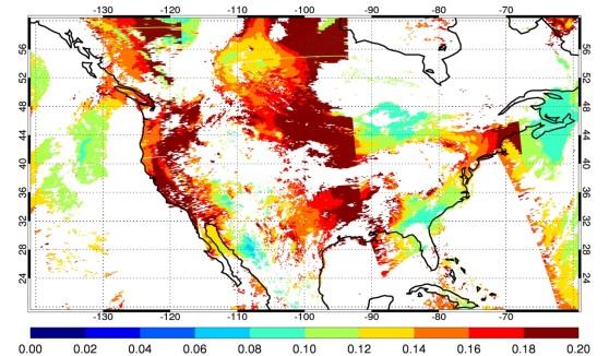


7 Scenario 2 Jan 3, % Improved Cloud Masking Analysis Apr 10, 2012 Jul 1, % 32% 16% Sept 25, % 13% 16% 16% At the TEMPO resolution the number of retrieval opportunities reduces by 50% in relation to a MODIS-like sensor.
8 Retrieving AOD from ABI observations (scenario 3) -High spatial resolution visible/near IR observations from the Advanced Base Imager (ABI) on NOAA s GOES R and S satellites can be used to generate land AOD product. -ABI s multi-spectral capability is similar to that of the EOS-MODIS (Terra and Aqua) sensors. -Three land AOD algorithms are currently applied to Aqua-MODIS observations: Dark Target (DT), Deep Blue (DB), and Multi-Angle Implementation of Atmospheric Correction (MAIAC). -The performance of each algorithm was evaluated using AERONET s measurements over the continental United States over 15 years.


9 Ground-Satellite Collocation criteria Geographical Distribution of AERONET Sites over North America Spatio-Temporal Approach + 40 km 40 km N min =160 ΔT =±30 mins. Satellite overpass time AERONET direct meas ΔT Only best quality satellite AOD retrievals are considered in this analysis.
10 Eastern N.A. Composite Independent comparison DT DB MAIAC N Corr. Slope Y-int RMSE Bias
11 Western N.A. Composite Independent comparison DT DB MAIAC N Corr. Slope Y-int RMSE Bias
12 AOD Difference as a function of Surface Reflectance Eastern N.A. Composite Western N.A. Composite - Overall, MAIAC retrievals compare better to AERONET observations - MAIAC s accurate retrieval capability extends to bright arid/semi-arid surfaces - MAIAC retrieval frequency is significantly higher than those of the DT and DB algorithms
13 Combined use of TEMPO-ABI to derive aerosol layer height (scenario 4) Application to collocated OMI Aqua-MODIS observations (Satheesh, Torres et al, JGR, 2009) OMI-MODIS Derived Height Gasso and Torres, AMT, 2016 Layer Height (Airborne Lidar) (km) Comparison of retrieved aerosol layer height to lidar observations
14 Summary -Adaptation of OMI aerosol algorithm to TEMPO is in progress (TEMPO support) -Benefits of the combined use of TEMPO-ABI have been demonstrated (GEOCAPE funded) -Funding is needed for implementation of a TEMPO-ABI application
Recent Update on MODIS C6 and VIIRS Deep Blue Aerosol Products
 Recent Update on MODIS C6 and VIIRS Deep Blue Aerosol Products N. Christina Hsu, Photo taken from Space Shuttle: Fierce dust front over Libya Corey Bettenhausen, Andrew M. Sayer, and Rick Hansell Laboratory
Satellite observation of atmospheric dust
 Satellite observation of atmospheric dust Taichu Y. Tanaka Meteorological Research Institute, Japan Meteorological Agency 11 April 2017, SDS WAS: Dust observation and modeling @WMO, Geneva Dust observations
Extending the Deep Blue aerosol record from SeaWiFS and MODIS to NPP-VIIRS
 Extending the Deep Blue aerosol record from SeaWiFS and MODIS to NPP-VIIRS Andrew M. Sayer, N. Christina Hsu (PI), Corey Bettenhausen, Jaehwa Lee Climate & Radiation Laboratory, NASA Goddard Space Flight
Aerosol absorption retrievals from base-line OCI observations
 Aerosol absorption retrievals from base-line OCI observations Lorraine Remer, UMBC Shana Mattoo, NASA GSFC Robert Levy, NASA GSFC Omar Torres, NASA GSFC Zia Ahmad, NASA GSFC Vanderlei Martins, UMBC Pawan
Satellite remote sensing of aerosols & clouds: An introduction
 Satellite remote sensing of aerosols & clouds: An introduction Jun Wang & Kelly Chance April 27, 2006 junwang@fas.harvard.edu Outline Principals in retrieval of aerosols Principals in retrieval of water
Projects in the Remote Sensing of Aerosols with focus on Air Quality
 Projects in the Remote Sensing of Aerosols with focus on Air Quality Faculty Leads Barry Gross (Satellite Remote Sensing), Fred Moshary (Lidar) Direct Supervision Post-Doc Yonghua Wu (Lidar) PhD Student
Aerosol Retrieved from MODIS: Algorithm, Products, Validation and the Future
 Aerosol Retrieved from MODIS: Algorithm, Products, Validation and the Future Presented by: Rob Levy Re-presenting NASA-GSFC s MODIS aerosol team: Y. Kaufman, L. Remer, A. Chu,, C. Ichoku,, R. Kleidman,,
Comparison of NASA AIRS and MODIS Land Surface Temperature and Infrared Emissivity Measurements from the EOS AQUA platform
 Comparison of NASA AIRS and MODIS Land Surface Temperature and Infrared Emissivity Measurements from the EOS AQUA platform Robert Knuteson, Steve Ackerman, Hank Revercomb, Dave Tobin University of Wisconsin-Madison
Satellite Constraints on Arctic-region Airborne Particles Ralph Kahn NASA Goddard Space Flight Center
 Satellite Constraints on Arctic-region Airborne Particles Ralph Kahn NASA Goddard Space Flight Center Sea of Okhotsk, MODIS image Feb. 6, 2007, NASA Earth Observatory Arctic Aerosol Remote Sensing Overview
Cloud masking as cross-cutting issue
 Cloud masking as cross-cutting issue Presentation to CEOS/WGCV activity project planning meeting Rainer Hollmann, Cornelia Schlundt, Satellite based Climate Monitoring Deutscher Wetterdienst Outline Need
PHEOS - Weather, Climate, Air Quality
 Aerosol & cloud remote sensing over the Arctic : perspectives for the PHEMOS and meteorological imager payloads on the PCW mission Norm O Neill, Auromeet Saha, U. de Sherbrooke Chris E. Sioris, Jack McConnell,
Melanie S. Hammer 1, Randall V. Martin 1,2, Aaron van Donkelaar 1, Virginie Buchard 3,4, Omar Torres 3, David A. Ridley 5, Robert J.D.
 Interpreting the Ultraviolet Aerosol Index Observed with the OMI Satellite Instrument to Understand Absorption by Organic Aerosols: Implications for Atmospheric Oxidation and Direct Radiative Effects Melanie
EUMETSAT atmospheric composition products and support to CAMS
 EUMETSAT atmospheric composition products and support to CAMS C. Retscher, R. Munro, R. Lang, R. Lindstrot, G. Poli, R. Huckle, N. Hao, S. Gimeno Garcia, A. Cacciari, A. Holdak, A. Kokhanovsky EUMETSAT
Sources and Properties of Atmospheric Aerosol in Texas: DISCOVER-AQ Measurements and Validation
 Sources and Properties of Atmospheric Aerosol in Texas: DISCOVER-AQ Measurements and Validation Thanks to: Rebecca Sheesley and Sascha Usenko, Baylor Barry Lefer, U. Houston, AQRP Sarah D. Brooks T. Ren,
Tracking On-orbit Radiometric Accuracy and Stability of Suomi NPP VIIRS using Extended Low Latitude SNOs
 Tracking On-orbit Radiometric Accuracy and Stability of Suomi NPP VIIRS using Extended Low Latitude SNOs Sirish Uprety a Changyong Cao b Slawomir Blonski c Xi Shao c Frank Padula d a CIRA, Colorado State
Introduction of the new Suomi-NPP VIIRS Aerosol Products
 Introduction of the new Suomi-NPP VIIRS Aerosol Products Jingfeng Huang 1,2, Ho-Chun Huang 1,2 Istvan Laszlo 2, Shobha Kondragunta 2 Hongqing Liu 2,3, Lorraine Remer 4, Hai Zhang 2,3 1 CICS-MD/ESSIC/UMD
Introduction of the new Suomi NPP VIIRS Aerosol Products
 Introduction of the new Suomi NPP VIIRS Aerosol Products Jingfeng Huang 1,2, Ho Chun Huang 1,2 Istvan Laszlo 2, Shobha Kondragunta 2 Hongqing Liu 2,3, Lorraine Remer 4, Hai Zhang 2,3 1 CICS-MD/ESSIC/UMD
NESDIS Polar (Region) Products and Plans. Jeff Key NOAA/NESDIS Madison, Wisconsin USA
 Products and Plans. Jeff Key NOAA/NESDIS Madison, Wisconsin USA") NESDIS Polar (Region) Products and Plans Jeff Key NOAA/NESDIS Madison, Wisconsin USA WMO Polar Space Task Group, 2 nd meeting, Geneva, 12 14 June 2012 Relevant Missions and Products GOES R ABI Fractional
NESDIS Polar (Region) Products and Plans Jeff Key NOAA/NESDIS Madison, Wisconsin USA WMO Polar Space Task Group, 2 nd meeting, Geneva, 12 14 June 2012 Relevant Missions and Products GOES R ABI Fractional
GSICS UV Sub-Group Activities
 GSICS UV Sub-Group Activities Rosemary Munro with contributions from NOAA, NASA and GRWG UV Subgroup Participants, in particular L. Flynn 1 CEOS Atmospheric Composition Virtual Constellation Meeting (AC-VC)
VIIRS Radiometric Calibration for Reflective Solar Bands: Antarctic Dome C Site and Simultaneous Nadir Overpass Observations
 VIIRS Radiometric Calibration for Reflective Solar Bands: Antarctic Dome C Site and Simultaneous Nadir Overpass Observations Slawomir Blonski, * Changyong Cao, Sirish Uprety, ** and Xi Shao * NOAA NESDIS
Seasonal Aerosol Vertical Distribution and Optical Properties over North China Xing-xing GAO, Yan CHEN, Lei ZHANG * and Wu ZHANG
 2017 International Conference on Energy, Environment and Sustainable Development (EESD 2017) ISBN: 978-1-60595-452-3 Seasonal Aerosol Vertical Distribution and Optical Properties over North China Xing-xing
2nd Annual CICS-MD Science Meeting November 6-7, 2013 Earth System Science Interdisciplinary Center University of Maryland, College Park, MD
 Development of Algorithms for Shortwave Radiation Budget from GOES-R R. T. Pinker, M. M. Wonsick GOES-R Algorithm Working Group Radiation Budget Application Team John A. Augustine (NOAA); Hye-Yun Kim (IMSG);
Estimation of ocean contribution at the MODIS near-infrared wavelengths along the east coast of the U.S.: Two case studies
 GEOPHYSICAL RESEARCH LETTERS, VOL. 32, L13606, doi:10.1029/2005gl022917, 2005 Estimation of ocean contribution at the MODIS near-infrared wavelengths along the east coast of the U.S.: Two case studies
Aerosol measurements from Space. Gerrit de Leeuw FMI & Uni of Helsinki, Finland & TNO, Utrecht, Netherlands
 Aerosol measurements from Space Gerrit de Leeuw FMI & Uni of Helsinki, Finland & TNO, Utrecht, Netherlands ACCENT AT-2 Follow-up meeting Mainz, 22 June 2009 ACCENT AT-2 Outcomes The Remote Sensing of Tropospheric
Evaluation of aerosol optical depth and aerosol models from VIIRS retrieval algorithms over North China Plain
 University of Nebraska - Lincoln DigitalCommons@University of Nebraska - Lincoln Papers in the Earth and Atmospheric Sciences Earth and Atmospheric Sciences, Department of 2017 Evaluation of aerosol optical
An Observational Study of the Relationship between Cloud, Aerosol and Meteorology in Marine Stratus Regions
 An Observational Study of the Relationship between Cloud, Aerosol and Meteorology in Marine Stratus Regions Norman G. Loeb NASA Langley Research Center Hampton, VA Oct 18 th, 2006, AeroCom Meeting (Virginia
A new perspective on aerosol direct radiative effects in South Atlantic and Southern Africa
 A new perspective on aerosol direct radiative effects in South Atlantic and Southern Africa Ian Chang and Sundar A. Christopher Department of Atmospheric Science University of Alabama in Huntsville, U.S.A.
Spectral surface albedo derived from GOME-2/Metop measurements
 Spectral surface albedo derived from GOME-2/Metop measurements Bringfried Pflug* a, Diego Loyola b a DLR, Remote Sensing Technology Institute, Rutherfordstr. 2, 12489 Berlin, Germany; b DLR, Remote Sensing
Observation of Smoke and Dust Plume Transport and Impact on the Air Quality Remote Sensing in New York City
 Observation of Smoke and Dust Plume Transport and Impact on the Air Quality Remote Sensing in New York City Yonghua Wu*, Chowdhury Nazmi, Cuiya Li, Daniel Hoyos, Barry Gross, Fred Moshary NOAA-CREST and
ACTRIS aerosol vertical profiles: advanced data and their potential use in a aerosol observations/models combined approach
 ACTRIS aerosol vertical profiles: advanced data and their potential use in a aerosol observations/models combined approach Lucia Mona CNR-IMAA, Potenza, Italy mona@imaa.cnr.it and EARLINET Team OUTLINE
Interpretation of Polar-orbiting Satellite Observations. Atmospheric Instrumentation
 Interpretation of Polar-orbiting Satellite Observations Outline Polar-Orbiting Observations: Review of Polar-Orbiting Satellite Systems Overview of Currently Active Satellites / Sensors Overview of Sensor
Introducing VIIRS Aerosol Products
 1 Introducing VIIRS Aerosol Products Shobha Kondragunta NOAA/NESDIS Center for Satellite Applications and Research VIIRS Aerosol Cal/Val Team 2 Name Organization Major Task Kurt F. Brueske IIS/Raytheon
New Generation Aerosol Satellite Products for Air Quality Mapping and Analysis
 New Generation Aerosol Satellite Products for Air Quality Mapping and Analysis Amy K. Huff Penn State University 2017 MARAMA Air Quality Monitoring Training Workshop November 3, 2017 Satellites Identify
Improving the CALIPSO VFM product with Aqua MODIS measurements
 University of Nebraska - Lincoln DigitalCommons@University of Nebraska - Lincoln NASA Publications National Aeronautics and Space Administration 2010 Improving the CALIPSO VFM product with Aqua MODIS measurements
Monitoring CO 2 Sources and Sinks from Space with the Orbiting Carbon Observatory (OCO)
") NACP Remote Sensing Breakout Monitoring CO 2 Sources and Sinks from Space with the Orbiting Carbon Observatory (OCO) http://oco.jpl.nasa.gov David Crisp, OCO PI (JPL/Caltech) January 2007 1 of 14, Crisp,
NACP Remote Sensing Breakout Monitoring CO 2 Sources and Sinks from Space with the Orbiting Carbon Observatory (OCO) http://oco.jpl.nasa.gov David Crisp, OCO PI (JPL/Caltech) January 2007 1 of 14, Crisp,
General Aspects I: What is a cloud?
 Cloud Detection General Aspects I: What is a cloud? I can tell you, if I see... A visible aggregate of minute water droplets and/or ice particles in the atmosphere above the earth s surface Global total
P3.24 EVALUATION OF MODERATE-RESOLUTION IMAGING SPECTRORADIOMETER (MODIS) SHORTWAVE INFRARED BANDS FOR OPTIMUM NIGHTTIME FOG DETECTION
 SHORTWAVE INFRARED BANDS FOR OPTIMUM NIGHTTIME FOG DETECTION") P3.24 EVALUATION OF MODERATE-RESOLUTION IMAGING SPECTRORADIOMETER (MODIS) SHORTWAVE INFRARED BANDS FOR OPTIMUM NIGHTTIME FOG DETECTION 1. INTRODUCTION Gary P. Ellrod * NOAA/NESDIS/ORA Camp Springs, MD
P3.24 EVALUATION OF MODERATE-RESOLUTION IMAGING SPECTRORADIOMETER (MODIS) SHORTWAVE INFRARED BANDS FOR OPTIMUM NIGHTTIME FOG DETECTION 1. INTRODUCTION Gary P. Ellrod * NOAA/NESDIS/ORA Camp Springs, MD
Role of Satellite and Remote Sensing in the Urban Environment
 Role of Satellite and Remote Sensing in the Urban Environment Jhoon Kim 1,2,5, Kelly Chance 2,5, Ben Veihelmann 3,5, Jay Al-Saadi 4,5 Pablo Saide 6 1 Yonsei University, Seoul, Korea 2 Harvard Smithonian
UKCA_RADAER Aerosol-radiation interactions
 UKCA_RADAER Aerosol-radiation interactions Nicolas Bellouin UKCA Training Workshop, Cambridge, 8 January 2015 University of Reading 2014 n.bellouin@reading.ac.uk Lecture summary Why care about aerosol-radiation
«Action Thématique Incitative sur Programme» CNRS/INSU
 Development and validation of a regional model of desert dust for the study of seasonal and interannual variations over Sahara and Sahel coupling with satellite observations «Action Thématique Incitative
Jun Mitch Goldberg %, Pei Timothy J. Schmit &, Jinlong Zhenglong and Agnes
 Progress on the assimilation of advanced IR sounder radiances in cloudy skies Jun Li @, Mitch Goldberg %, Pei Wang @#, Timothy J. Schmit &, Jinlong Li @, Zhenglong Li @, and Agnes Lim @ @CIMSS, University
Sand and Dust Monitoring in RA II
 Sand and Dust Monitoring in RA II Xiang Fang National Satellite Meteorological Center,CMA Outline Dust products in RA II Validation of multi-satellite products Action Proposed Dust products in RA II Operational
McIDAS support of Suomi-NPP /JPSS and GOES-R L2
 McIDAS support of Suomi-NPP /JPSS and GOES-R L2 William Straka III 1 Tommy Jasmin 1, Bob Carp 1 1 Cooperative Institute for Meteorological Satellite Studies, Space Science and Engineering Center, University
Development of an Operational Multi-sensor and Multi-channel Aerosol Assimilation Package Using NAAPS and NAVDAS
 DISTRIBUTION STATEMENT A: Approved for public release; distribution is unlimited. Development of an Operational Multi-sensor and Multi-channel Aerosol Assimilation Package Using NAAPS and NAVDAS Jianglong
Long-Term Time Series of Water Vapour Total Columns from GOME, SCIAMACHY and GOME-2
 Graphics: ESA Graphics: ESA Graphics: ESA Long-Term Time Series of Water Vapour Total Columns from GOME, SCIAMACHY and GOME-2 S. Noël, S. Mieruch, H. Bovensmann, J. P. Burrows Institute of Environmental
AATSR atmospheric correction
 AATSR atmospheric correction Objective: Retrieval of aerosol opacity and bidirectional reflectance over land surface Talk structure Science background and objectives Dual-angle method Validation and satellite
Methane Sensing Flight of Scanning HIS over Hutchinson, KS, 31 March 2001
 Methane Sensing Flight of Scanning HIS over Hutchinson, KS, 31 March 2001 Hank Revercomb, Chris Moeller, Bob Knuteson, Dave Tobin, Ben Howell University of Wisconsin, Space Science and Engineering Center
A Method for MERIS Aerosol Correction : Principles and validation. David Béal, Frédéric Baret, Cédric Bacour, Kathy Pavageau
 A Method for MERIS Aerosol Correction : Principles and validation David Béal, Frédéric Baret, Cédric Bacour, Kathy Pavageau Outlook Objectives Principles Training neural networks Validation Comparison
Application of Aura/OMI PBL SO 2 product for estimating SO 2 emissions and future enhancements from new satellite missions
 Application of Aura/OMI PBL SO 2 product for estimating SO 2 emissions and future enhancements from new satellite missions 1 N. Krotkov, 2 V. Fioletov, 3,1 K. Yang, 4,1 Can Li, 3 R. Dickerson & Aura/OMI
ESA Climate Change Initiative (CCI)
") ESA Climate Change Initiative (CCI) New ESA Programme with the aim to contribute to worldwide efforts to generate Essential Climate Variables (ECVs) C. Zehner Barcelona, 07/09/2009 Two climate action paths
ESA Climate Change Initiative (CCI) New ESA Programme with the aim to contribute to worldwide efforts to generate Essential Climate Variables (ECVs) C. Zehner Barcelona, 07/09/2009 Two climate action paths
Satellite observations of aerosols and related gases and applications for aerosol deposition
 Satellite observations of aerosols and related gases and applications for aerosol deposition Mian Chin 1, HongbinYu 1, P.K. Bhartia 1, JassimAl-Saadi 2, ShobhaKongragunta 3, Alexei Lyapustin 1, Omar Torres
In-flight Calibration Techniques Using Natural Targets. CNES Activities on Calibration of Space Sensors
 In-flight Calibration Techniques Using Natural Targets CNES Activities on Calibration of Space Sensors Bertrand Fougnie, Patrice Henry (DCT/SI, CNES, Toulouse, France) In-flight Calibration using Natural
Jun Park National Meteorological Satellite Center Korea Meteorological Administration
 KMA Implementation Plan for Satellite Climate products Jun Park National Meteorological Satellite Center Korea Meteorological Administration jun.park@kma.go.kr Outline 1. Introduction : Current & Future
Airborne High Spectral Resolution Lidar Aerosol Measurements and Comparisons with GEOS-5 Model
 Airborne High Spectral Resolution Lidar Aerosol Measurements and Comparisons with GEOS-5 Model Richard Ferrare, Chris Hostetler, John Hair, Anthony Cook, David Harper, Mike Obland, Ray Rogers, Sharon Burton,
The Orbiting Carbon Observatory (OCO)
") GEMS 2006 Assembly The Orbiting Carbon Observatory (OCO) http://oco.jpl.nasa.gov David Crisp, OCO PI (JPL/Caltech) February 2006 1 of 13, OCO Dec 2005 Page 1 The Orbiting Carbon Observatory (OCO) OCO will
GEMS 2006 Assembly The Orbiting Carbon Observatory (OCO) http://oco.jpl.nasa.gov David Crisp, OCO PI (JPL/Caltech) February 2006 1 of 13, OCO Dec 2005 Page 1 The Orbiting Carbon Observatory (OCO) OCO will
THE GLI 380-NM CHANNEL APPLICATION FOR SATELLITE REMOTE SENSING OF TROPOSPHERIC AEROSOL
 THE GLI 380-NM CHANNEL APPLICATION FOR SATELLITE REMOTE SENSING OF TROPOSPHERIC AEROSOL Robert Höller, 1 Akiko Higurashi 2 and Teruyuki Nakajima 3 1 JAXA, Earth Observation Research and Application Center
Application of a Land Surface Temperature Validation Protocol to AATSR data. Dar ren Ghent1, Fr ank Göttsche2, Folke Olesen2 & John Remedios1
 Application of a Land Surface Temperature Validation Protocol to AATSR data Dar ren Ghent1, Fr ank Göttsche, Folke Olesen & John Remedios1 1 E a r t h O b s e r v a t i o n S c i e n c e, D e p a r t m
MSI aerosol retrieval algorithm for the Multi- Spectral Imager (MSI) on EarthCare
 on EarthCare") MSI aerosol retrieval algorithm for the Multi- Spectral Imager (MSI) on EarthCare Wolfgang von Hoyningen-Huene Huene,, Alexander Kokhanovsky, Vladimir Rozanov,, John P. Burrows,, Gerard Hesselmans 2),
MSI aerosol retrieval algorithm for the Multi- Spectral Imager (MSI) on EarthCare Wolfgang von Hoyningen-Huene Huene,, Alexander Kokhanovsky, Vladimir Rozanov,, John P. Burrows,, Gerard Hesselmans 2),
On the Satellite Determination of Multilayered Multiphase Cloud Properties. Science Systems and Applications, Inc., Hampton, Virginia 2
 JP1.10 On the Satellite Determination of Multilayered Multiphase Cloud Properties Fu-Lung Chang 1 *, Patrick Minnis 2, Sunny Sun-Mack 1, Louis Nguyen 1, Yan Chen 2 1 Science Systems and Applications, Inc.,
Mapping of Optical Parameters of Aerosols over Land using Multi-Spectral IRS-P4 OCM Sensor Data
 Mapping of Optical Parameters of Aerosols over Land using Multi-Spectral IRS-P4 OCM Sensor Data Rajshree Rege #, M. B. Potdar #, P. C. S. Devara @ and B. P. Agrawal & # Space Applications Centre, Ahmedabad
Using Airborne High Spectral Resolution Lidar Data to Evaluate Combined Active/Passive Retrievals of Aerosol Extinction Profiles
 Using Airborne High Spectral Resolution Lidar Data to Evaluate Combined Active/Passive Retrievals of Aerosol Extinction Profiles Richard Ferrare, Sharon Burton, Chris Hostetler, John Hair, Anthony Cook,
Introducing Atmospheric Motion Vectors Derived from the GOES-16 Advanced Baseline Imager (ABI)
") Introducing Atmospheric Motion Vectors Derived from the GOES-16 Advanced Baseline Imager (ABI) Jaime Daniels NOAA/NESDIS, Center for Satellite Applications and Research Wayne Bresky, Andrew Bailey, Americo
Introducing Atmospheric Motion Vectors Derived from the GOES-16 Advanced Baseline Imager (ABI) Jaime Daniels NOAA/NESDIS, Center for Satellite Applications and Research Wayne Bresky, Andrew Bailey, Americo
Status of Land Surface Temperature Product Development for JPSS Mission
 Status of Land Surface Temperature Product Development for JPSS Mission Yuling Liu 1,2, Yunyue Yu 2, Peng Yu 1,2 and Heshun Wang 1,2 1 ESSIC at University of Maryland, College Park, MD USA 2 Center for
Aerosol Impact on Infrared METOC Data Assimilation
 DISTRIBUTION STATEMENT A. Approved for public release; distribution is unlimited. Aerosol Impact on Infrared METOC Data Assimilation Douglas L. Westphal Naval Research Laboratory 7 Grace Hopper Ave, Stop
Aerosol Impacts on Earth s Energy Budget: What We Can Say, and What We Can t. Ralph Kahn NASA Goddard Space Flight Center
 Aerosol Impacts on Earth s Energy Budget: What We Can Say, and What We Can t Ralph Kahn NASA Goddard Space Flight Center Trenberth, Fasullo, Kiehl, BAMS 2009 Even DARF and Anthropogenic DARF are NOT Solved
Vicarious calibration of GLI by global datasets. Calibration 5th Group Hiroshi Murakami (JAXA EORC)
") Vicarious calibration of GLI by global datasets Calibration 5th Group Hiroshi Murakami (JAXA EORC) ADEOS-2 PI workshop March 2004 1 0. Contents 1. Background 2. Operation flow 3. Results 4. Temporal change
Vicarious calibration of GLI by global datasets Calibration 5th Group Hiroshi Murakami (JAXA EORC) ADEOS-2 PI workshop March 2004 1 0. Contents 1. Background 2. Operation flow 3. Results 4. Temporal change
Instrumentation planned for MetOp-SG
 Instrumentation planned for MetOp-SG Bill Bell Satellite Radiance Assimilation Group Met Office Crown copyright Met Office Outline Background - the MetOp-SG programme The MetOp-SG instruments Summary Acknowledgements:
On the use of satellite remote sensing to determine direct aerosol radiative effect over land : A case study over China
 On the use of satellite remote sensing to determine direct aerosol radiative effect over land : A case study over China Anu-Maija Sundström, Antti Arola, Pekka Kolmonen, Gerrit de Leeuw, and Markku Kulmala
Some NOAA Products that Address PSTG Satellite Observing Requirements. Jeff Key NOAA/NESDIS Madison, Wisconsin USA
 Some NOAA Products that Address PSTG Satellite Observing Requirements Jeff Key NOAA/NESDIS Madison, Wisconsin USA WMO Polar Space Task Group, 4 th meeting, Greenbelt, 30 September 2014 Relevant Missions
Recent Developments in Global Aerosol Forecasting at NRL
 Recent Developments in Global Aerosol Forecasting at NRL J.S. Reid, D. Westphal, J Campbell, E. Hyer, & A. Walker, NRL Monterey P. Lynch & W. Sessions, CSC J. Zhang and Y. Shi, UND November, 2013 NCAR
GIFTS SOUNDING RETRIEVAL ALGORITHM DEVELOPMENT
 P2.32 GIFTS SOUNDING RETRIEVAL ALGORITHM DEVELOPMENT Jun Li, Fengying Sun, Suzanne Seemann, Elisabeth Weisz, and Hung-Lung Huang Cooperative Institute for Meteorological Satellite Studies (CIMSS) University
Overview: Scope and Goals
 Overview: Scope and Goals Current operational NOAA instruments: AVHRR, HIRS, SBUV, GOES Imagers/Sounders; Non-NOAA satellites/sensors; Future: MetOP and NPP/NPOESS; GOES-R Assure Functionality of Current/Near-Future
Deep Blue Retrievals of Asian Aerosol Properties During ACE-Asia
 3180 IEEE TRANSACTIONS ON GEOSCIENCE AND REMOTE SENSING, VOL. 44, NO. 11, NOVEMBER 2006 Deep Blue Retrievals of Asian Aerosol Properties During ACE-Asia N. Christina Hsu, Si-Chee Tsay, Michael D. King,
Net Surface Shortwave Radiation from GOES Imagery Product Evaluation Using Ground-Based Measurements from SURFRAD
 Remote Sens. 2015, 7, 10788-10814; doi:10.3390/rs70810788 Article OPEN ACCESS remote sensing ISSN 2072-4292 www.mdpi.com/journal/remotesensing Net Surface Shortwave Radiation from GOES Imagery Product
THE LAND-SAF SURFACE ALBEDO AND DOWNWELLING SHORTWAVE RADIATION FLUX PRODUCTS
 THE LAND-SAF SURFACE ALBEDO AND DOWNWELLING SHORTWAVE RADIATION FLUX PRODUCTS Bernhard Geiger, Dulce Lajas, Laurent Franchistéguy, Dominique Carrer, Jean-Louis Roujean, Siham Lanjeri, and Catherine Meurey
Supplement of Cloud and aerosol classification for 2.5 years of MAX-DOAS observations in Wuxi (China) and comparison to independent data sets
 and comparison to independent data sets") Supplement of Atmos. Meas. Tech., 8, 5133 5156, 215 http://www.atmos-meas-tech.net/8/5133/215/ doi:1.5194/amt-8-5133-215-supplement Author(s) 215. CC Attribution 3. License. Supplement of Cloud and aerosol
Supplement of Atmos. Meas. Tech., 8, 5133 5156, 215 http://www.atmos-meas-tech.net/8/5133/215/ doi:1.5194/amt-8-5133-215-supplement Author(s) 215. CC Attribution 3. License. Supplement of Cloud and aerosol
Satellite remote sensing of aerosols Past, present and future
 June 28, 2013, Tsukuba Satellite remote sensing of aerosols Past, present and future Terry Nakajima Atmosphere and Ocean Research Institute, University of Tokyo teruyuki.nakajima@aori.u-tokyo.ac.jp Aerosol
Launched on May 4, K. Hokusai
 CITES-2009 CITES-2009 CONFERENCE CONFERENCE KRASNOYARSK, KRASNOYARSK, Russia Russia OBSERVING THE EARTH FROM SPACE AS AN INTEGRATED SYSTEM: THE USA/F* A-TRAIN CONCEPT G. BEGNI, D. RENAUT (CNES CNES), D.
Preliminary testing of new approaches to retrieve aerosol properties from joint photometer-lidar inversion
 ESA/IDEAS Project- WP 3440-2 Preliminary testing of new approaches to retrieve aerosol properties from joint photometer-lidar inversion Q. Hu, P. Goloub, O. Dubovik, A. Lopatin, T. Povdin, T. Lopyonok,
Introduction of the Hyperspectral Environmental Suite (HES) on GOES-R and beyond
 on GOES-R and beyond") Introduction of the Hyperspectral Environmental Suite (HES) on GOES-R and beyond Timothy J. Schmit SaTellite Applications and Research (STAR) Advanced Satellite Products Team (ASPT) Presented by Jun Li
Introduction of the Hyperspectral Environmental Suite (HES) on GOES-R and beyond Timothy J. Schmit SaTellite Applications and Research (STAR) Advanced Satellite Products Team (ASPT) Presented by Jun Li
Aerosol Optical Depth Variation over European Region during the Last Fourteen Years
 Aerosol Optical Depth Variation over European Region during the Last Fourteen Years Shefali Singh M.Tech. Student in Computer Science and Engineering at Meerut Institute of Engineering and Technology,
A 2016 CEOS Chair Initiative. Non-meteorological Applications for Next Generation Geostationary Satellites
 A 2016 CEOS Chair Initiative Committee on Earth Observation Satellites Non-meteorological Applications for Next Generation Geostationary Satellites Co-chaired by EUMETSAT (Holmlund), CSIRO (Schroeder),
REVISION OF THE STATEMENT OF GUIDANCE FOR GLOBAL NUMERICAL WEATHER PREDICTION. (Submitted by Dr. J. Eyre)
") WORLD METEOROLOGICAL ORGANIZATION Distr.: RESTRICTED CBS/OPAG-IOS (ODRRGOS-5)/Doc.5, Add.5 (11.VI.2002) COMMISSION FOR BASIC SYSTEMS OPEN PROGRAMME AREA GROUP ON INTEGRATED OBSERVING SYSTEMS ITEM: 4 EXPERT
WORLD METEOROLOGICAL ORGANIZATION Distr.: RESTRICTED CBS/OPAG-IOS (ODRRGOS-5)/Doc.5, Add.5 (11.VI.2002) COMMISSION FOR BASIC SYSTEMS OPEN PROGRAMME AREA GROUP ON INTEGRATED OBSERVING SYSTEMS ITEM: 4 EXPERT
Remote Sensing of Snow GEOG 454 / 654
 Remote Sensing of Snow GEOG 454 / 654 What crysopheric questions can RS help to answer? 2 o Where is snow lying? (Snow-covered area or extent) o How much is there? o How rapidly is it melting? (Area, depth,
TESTS. GRASP sensitivity. Observation Conditions. Retrieval assumptions ISTINA-WP AERO. MODELS. B. Torres, O. Dubovik and D.
 TESTS Retrieval assumptions GRASP sensitivity ISTINA-WP3380-2 Observation Conditions AERO. MODELS B. Torres, O. Dubovik and D. Fuertes Introduction Scope of ISTINA-WP3380-2 To establish fundamental limits
The potential impact of ozone sensitive data from MTG-IRS
 The potential impact of ozone sensitive data from MTG-IRS R. Dragani, C. Lupu, C. Peubey, and T. McNally ECMWF rossana.dragani@ecmwf.int ECMWF May 24, 2017 The MTG IRS Long-Wave InfraRed band O 3 Can the
Atmospheric Correction Using Hyperion
 Atmospheric Correction Using Hyperion Progress and Issues Investigation: Correlative Analysis of EO-1, Landsat, and Terra Data of the DOE ARM CART Sites: An Investigation of Instrument Performance and
Infrared continental surface emissivity spectra and skin temperature retrieved from IASI observation
 Infrared continental surface emissivity spectra and skin temperature retrieved from IASI observation Capelle V., Chédin A., Péquignot E., N. A Scott Schlüssel P., Newman S. IASI Conference 2013 Introduction
Chapter 4 Nadir looking UV measurement. Part-I: Theory and algorithm
 Chapter 4 Nadir looking UV measurement. Part-I: Theory and algorithm -Aerosol and tropospheric ozone retrieval method using continuous UV spectra- Atmospheric composition measurements from satellites are
NIR Solar Reference Spectrum Algorithm for the Orbiting Carbon Observatory (OCO)
") NIR Solar Reference Spectrum Algorithm for the Orbiting Carbon Observatory (OCO) Hartmut Bösch and Geoffrey Toon Jet Propulsion Laboratory, California Institute of Technology OCO Mission Global, space-based
NIR Solar Reference Spectrum Algorithm for the Orbiting Carbon Observatory (OCO) Hartmut Bösch and Geoffrey Toon Jet Propulsion Laboratory, California Institute of Technology OCO Mission Global, space-based
SpexOne for the NASA PACE Mission
 SpexOne for the NASA PACE Mission Otto Hasekamp, Jeroen Rietjens, Antonio di Noia, Guangliang Fu, Lianghai Wu, Jochen Landgraf, Martijn Smit, Aaldert van Amerongen Programmatic Matters External funding
A Facility for Producing Consistent Remotely Sensed Biophysical Data Products of Australia
 TERRESTRIAL ECOSYSTEM RESEARCH NETWORK - AusCover - A Facility for Producing Consistent Remotely Sensed Biophysical Data Products of Australia June, 2011 Mervyn Lynch Professor of Remote Sensing Curtin
The identification and tracking of volcanic ash using the Meteosat Second Generation (MSG) Spinning Enhanced Visible and Infrared Imager (SEVIRI)
 Spinning Enhanced Visible and Infrared Imager (SEVIRI)") doi:10.5194/amt-7-581-2014 Author(s) 2014. CC Attribution 3.0 License. Atmospheric Measurement Techniques Open Access The identification and tracking of volcanic ash using the Meteosat Second Generation
doi:10.5194/amt-7-581-2014 Author(s) 2014. CC Attribution 3.0 License. Atmospheric Measurement Techniques Open Access The identification and tracking of volcanic ash using the Meteosat Second Generation
GOSAT update. June Prepared by JAXA EORC Presented by David Crisp
 CEOS AC-VC GOSAT update June Prepared by JAXA EORC Presented by David Crisp GOSAT & GOSAT-2 Organization ORGANIZATION GOSAT is the joint project of JAXA, MOE (Ministry of the Environment) and NIES (National
PUBLICATIONS. Journal of Geophysical Research: Atmospheres
 PUBLICATIONS Journal of Geophysical Research: Atmospheres RESEARCH ARTICLE Key Points: VIIRS is the mainstay polar-orbiting sensor, and its aerosol products are the primary global aerosol data once the
Cloud screening and snow detection with MERIS. Rene Preusker, Jürgen Fischer, Carsten Brockmann, Marco Zühlke, Uwe krämer, Anja Hünerbein
 Cloud screening and snow detection with MERIS Rene Preusker, Jürgen Fischer, Carsten Brockmann, Marco Zühlke, Uwe krämer, Anja Hünerbein Prelude The following algorithm has been compiled in the frame of
MISR remote sensing of tropospheric aerosols
 MISR remote sensing of tropospheric aerosols David J. Diner, John V. Martonchik, Ralph A. Kahn Jet Propulsion Laboratory, California Institute of Technology Michel M. Verstraete Institute for Environment
Lecture 4b: Meteorological Satellites and Instruments. Acknowledgement: Dr. S. Kidder at Colorado State Univ.
 Lecture 4b: Meteorological Satellites and Instruments Acknowledgement: Dr. S. Kidder at Colorado State Univ. US Geostationary satellites - GOES (Geostationary Operational Environmental Satellites) US
Improving Tropical Cyclone Forecasts by Assimilating Microwave Sounder Cloud-Screened Radiances and GPM precipitation measurements
 Improving Tropical Cyclone Forecasts by Assimilating Microwave Sounder Cloud-Screened Radiances and GPM precipitation measurements Hyojin Han a, Jun Li a, Mitch Goldberg b, Pei Wang a,c, Jinlong Li a,
Himawari-8/9 and GCOM-C Non-Meteorological Application Opportunities
 Himawari-8/9 and GCOM-C Non-Meteorological Application Opportunities Alex Held Centre for Australian Weather and Climate Research CAWCR December 2013 Selected materials from C. Down BoM) Non-Meteorological