Cloud screening and snow detection with MERIS. Rene Preusker, Jürgen Fischer, Carsten Brockmann, Marco Zühlke, Uwe krämer, Anja Hünerbein
|
|
|
- Clarissa Richards
- 5 years ago
- Views:
Transcription
1 Cloud screening and snow detection with MERIS Rene Preusker, Jürgen Fischer, Carsten Brockmann, Marco Zühlke, Uwe krämer, Anja Hünerbein
2 Prelude The following algorithm has been compiled in the frame of the ALBEDOMAP project (the generation of global 16 day spectral albedo maps; see presentation of J. Fischer). It is therefore limited to land surfaces!
3 Outline Objectives Algorithm Likelihood of cloudiness blue band screening cloud edge processing snow restoration analysis of short term variability analysis of long term variability Summary
4 Objective, or: Why did we need a new cloud detection? There is a standard cloud detection in MEGS. It is using two prominent features of clouds: 1. clouds are white 2. clouds are bright from satellite. This is by far not enough since: 1. it misses many thin clouds 2. it treats often snow as clouds (same for sun-glint) 3. it misses partly cloudy pixel In 16 days averages (with 1-6 overpaths) only one missed cloud destroys any kind of average


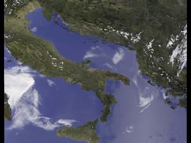
5 Example for insufficient MERIS L2 cloud detection RGB MERIS L2


6 Example for insufficient MERIS L2 cloud detection RGB MERIS L2
7 Algorithm: Likelihood of cloudiness Clouds are white Clouds are bright Clouds are higher than ground Direct utilization of the O 2 absorption band measured by MERIS at 760nm
8 Oxygen-A band differential absorption radiance ratio between an absorbing and a window channel depends on photon path length photon path length is mainly determined by air-mass above the cloud = cloud top pressure small ratio == no/low cloud ratio close to 1 == high (opaque) cloud
9 Sketch of Implementation Refl 1 Refl 2 Refl 3 Cls are bright Cls are white Cls are high Refl 4 Refl 5 Refl 6 Refl 9 Refl 10 Refl 13 O2A Srf.-Press Wvl 11 Cloudiness Probability Estimator (based on huge amount of RTM simulations, ANN ) Likelihood of clouds
10 Intermediate Although the cloud probability processor is working much better than the standard L2 processing: 1. many, especially thin/broken clouds slip through 2. snow had often a high cloud probability --> Need for some additional spectral filter to find partially cloudy pixel and a snow restoration
11 Blue band thresholding Physical Background: surfaces are very dark in the blue (412 nm) exceptions are: Clouds Snow ( applicable Sunglint (not very high aerosol loadings (difficult atmospheric correction --> unwanted) Implementation: Simple threshold of 0.2 in (Rayleigh corrected) ρ
12 Snow restoration Why wanted: Cloud probability and blue band threshold often falsely identify snow as cloud Physical Background: snow shows absorption in SWIR, that other surfaces don't show. Exceptions: water, but this is very dark in NIR few desert sites, but these are very dark in UV (!! climatology ) some huge tropical clouds This absorption is not very pronounced for the MERIS channels, but (thanks to MERIS's excellent radiometric resolution) sufficient!


13 Snow restoration example MERIS norm. diff. snow index: mndsi := (13-14)/(13+14) If (mndsi > 0.02) and not dark and not (sub)tropics then SNOW
14 Cloud edge processing Why wanted: Cloud shadow can not be adequately atmospherically corrected partially cloudy pixel are more often close to cloudy pixel removal of adjacency effects (brightening) due to clouds Implementation: 4x4 neighborhood around clouds is automatically excluded cloud shadow is geometrically calculated from MERIS ctp and sun geometry
15 Post processing Although we squeezed out the spectral potential of MERIS we still missed many, especially thin/broken clouds! --> Need to extend the feature vector by a temporal dimension. (This is of course only possible when producing some kind of L3)
16 Analysis of 16 day (short term) temporal variability in the blue band Physical background: Most land surfaces are very dark in UV. Exception: snow --> small cloud contaminations are first seen in the UV Implementation (empirical): If variability in 16 day bin exceeds 12.5% then each ρ > (16_day_mean + 2 stdv) is excluded If variability in 16 day bin exceeds 25% then each ρ > (16_day_mean + 1 stdv) is excluded
17 Analysis of the (long term) temporal variability in the blue band This test is not an test on ρ! Instead it finds L3 means/albedos which are still cloud contaminated. Why wanted: 16 day (short term) variability is in some cases not applicable, in particular when the weather is not changing during that time period. Low 16 day variability because of constant partly cloud cover false negative Implementation: A L3 bin is assumed to be cloud contaminated if the white sky albedo at 412nm exceeds the annual median by 50%. (Plus some extra logic to ( snow avoid false positive by

18

19
20 Summary 1. MERIS is NOT a god instrument to detect clouds (missing SWIR an TIR channels) even though all standard MERIS algorithms need a preceding cloud screening or cloud detection. (OLCI will benefit from SLSTR!!!) 2. We developed an highly improved cloud detection using all spectral features some temporal information almost no textual information 3. The investigation of MERIS L3 16 day albedo (which is very sensitive) indicates high quality of cloud detection (however a comparison with thermal sensors and ground ( different based measurements may look
General Aspects I: What is a cloud?
 Cloud Detection General Aspects I: What is a cloud? I can tell you, if I see... A visible aggregate of minute water droplets and/or ice particles in the atmosphere above the earth s surface Global total
In-flight Spectral Calibration of MERIS/OLCI. Jürgen Fischer, Rene Preusker, Rasmus Lindstrot Institute for Space Science Free University Berlin
 In-flight Spectral Calibration of MERIS/OLCI Jürgen Fischer, Rene Preusker, Rasmus Lindstrot Institute for Space Science Free University Berlin 1 MERIS Instrument 2 MERIS Instrument Concept 3 MERIS Operation
Cloud masking as cross-cutting issue
 Cloud masking as cross-cutting issue Presentation to CEOS/WGCV activity project planning meeting Rainer Hollmann, Cornelia Schlundt, Satellite based Climate Monitoring Deutscher Wetterdienst Outline Need
MERIS, A-MODIS, SeaWiFS, AATSR and PARASOL over the Salar de Uyuni March 2006 MAVT 2006 Marc Bouvet, ESA/ESTEC
 MERIS, A-MODIS, SeaWiFS, AATSR and PARASOL over the Salar de Uyuni Plan of the presentation 1. Introduction : from absolute vicarious calibration to radiometric intercomparison 2. Intercomparison at TOA
In-flight Calibration Techniques Using Natural Targets. CNES Activities on Calibration of Space Sensors
 In-flight Calibration Techniques Using Natural Targets CNES Activities on Calibration of Space Sensors Bertrand Fougnie, Patrice Henry (DCT/SI, CNES, Toulouse, France) In-flight Calibration using Natural
Spectral surface albedo derived from GOME-2/Metop measurements
 Spectral surface albedo derived from GOME-2/Metop measurements Bringfried Pflug* a, Diego Loyola b a DLR, Remote Sensing Technology Institute, Rutherfordstr. 2, 12489 Berlin, Germany; b DLR, Remote Sensing
Hyperspectral Atmospheric Correction
 Hyperspectral Atmospheric Correction Bo-Cai Gao June 2015 Remote Sensing Division Naval Research Laboratory, Washington, DC USA BACKGROUND The concept of imaging spectroscopy, or hyperspectral imaging,
Sentinel-3 Sea and Land Surface Temperature Radiometer (SLSTR) Mireya Etxaluze (STFC RAL Space)
 Mireya Etxaluze (STFC RAL Space)") Sentinel-3 Sea and Land Surface Temperature Radiometer (SLSTR) Mireya Etxaluze (STFC RAL Space) RAL Space Radiometry Group Dave Smith Mireya Etxaluze, Ed Polehampton, Caroline Cox, Tim Nightingale, Dan
Sentinel-3 Sea and Land Surface Temperature Radiometer (SLSTR) Mireya Etxaluze (STFC RAL Space) RAL Space Radiometry Group Dave Smith Mireya Etxaluze, Ed Polehampton, Caroline Cox, Tim Nightingale, Dan
Sentinel 2 Pre-processing Requirements for coastal and inland waters
 Sentinel 2 Pre-processing Requirements for coastal and inland waters K A I S Ø R E NSEN NIVA CARSTEN B R O CKMANN Ecological and chemical classification of water bodies in Norway Water quality - products
Long-Term Time Series of Water Vapour Total Columns from GOME, SCIAMACHY and GOME-2
 Graphics: ESA Graphics: ESA Graphics: ESA Long-Term Time Series of Water Vapour Total Columns from GOME, SCIAMACHY and GOME-2 S. Noël, S. Mieruch, H. Bovensmann, J. P. Burrows Institute of Environmental
PROBA-V CLOUD MASK VALIDATION
 Version: 1 Page 1 PROBA-V CLOUD MASK VALIDATION Validation Report Version 1.0 Kerstin Stelzer, Michael Paperin, Grit Kirches, Carsten Brockmann 25.04.2016 Version: 1 Page 2 Table of content Abbreviations
Status of CNES Cal/Val Activities
 GSICS Executive Panel Meeting 16-17th May 2014, Guangzhou, China Status of CNES Cal/Val Activities Patrice Henry CNES 1 Summary Overview of CNES Cal/Val Activities Summary Re-Calibration Activities POLDER(s)/PARASOL
VERIFICATION OF MERIS LEVEL 2 PRODUCTS: CLOUD TOP PRESSURE AND CLOUD OPTICAL THICKNESS
 VERIFICATION OF MERIS LEVEL 2 PRODUCTS: CLOUD TOP PRESSURE AND CLOUD OPTICAL THICKNESS Rene Preusker, Peter Albert and Juergen Fischer 17th December 2002 Freie Universitaet Berlin Institut fuer Weltraumwissenschaften
MSI aerosol retrieval algorithm for the Multi- Spectral Imager (MSI) on EarthCare
 on EarthCare") MSI aerosol retrieval algorithm for the Multi- Spectral Imager (MSI) on EarthCare Wolfgang von Hoyningen-Huene Huene,, Alexander Kokhanovsky, Vladimir Rozanov,, John P. Burrows,, Gerard Hesselmans 2),
MSI aerosol retrieval algorithm for the Multi- Spectral Imager (MSI) on EarthCare Wolfgang von Hoyningen-Huene Huene,, Alexander Kokhanovsky, Vladimir Rozanov,, John P. Burrows,, Gerard Hesselmans 2),
(A)ATSR and SLSTR VIS/SWIR Channels Calibration
ATSR and SLSTR VIS/SWIR Channels Calibration") (A)ATSR and SLSTR VIS/SWIR Channels Calibration Dave Smith & Mireya Etxaluze 2017 RAL Space 1 ATSR Series 1991-2000 ATSR-1 1995-2008 ATSR-2 2002-2012- AATSR 2 SLSTR Series 2016 Sentinel 3A 2018 Sentinel
(A)ATSR and SLSTR VIS/SWIR Channels Calibration Dave Smith & Mireya Etxaluze 2017 RAL Space 1 ATSR Series 1991-2000 ATSR-1 1995-2008 ATSR-2 2002-2012- AATSR 2 SLSTR Series 2016 Sentinel 3A 2018 Sentinel
Sentinel-2 and Sentinel-3 absolute calibration monitoring. C. Desjardins & V. Lonjou CNES
 Sentinel-2 and Sentinel-3 absolute calibration monitoring C. Desjardins & V. Lonjou CNES Radiometric S2A Calibration RRQI, 28 January Workshop, 2016, 30-31/08/2017 CNES SUMMARY CALCON Aug 22-25 2017 VICARIOUS
Cloud analysis from METEOSAT data using image segmentation for climate model verification
 Cloud analysis from METEOSAT data using image segmentation for climate model verification R. Huckle 1, F. Olesen 2 Institut für Meteorologie und Klimaforschung, 1 University of Karlsruhe, 2 Forschungszentrum
Algorithm for MERIS land surface BRDF/albedo retrieval and its validation using contemporaneous EO data products
 Algorithm for MERIS land surface BRDF/albedo retrieval and its validation using contemporaneous EO data products Jan-Peter Muller* (UCL) Carsten Brockmann, Marco Zühlke, Norman Fomferra (BC) Jürgen Fischer,
Cloud detection using SEVIRI IR channels
 Cloud detection using SEVIRI IR channels Alessandro.Ipe@oma.be & Luis Gonzalez Sotelino Royal Meteorological Institute of Belgium GERB Science Team Meeting @ London September 9 10 2009 1 / 19 Overview
A Method for MERIS Aerosol Correction : Principles and validation. David Béal, Frédéric Baret, Cédric Bacour, Kathy Pavageau
 A Method for MERIS Aerosol Correction : Principles and validation David Béal, Frédéric Baret, Cédric Bacour, Kathy Pavageau Outlook Objectives Principles Training neural networks Validation Comparison
TEMPO Aerosols. Need for TEMPO-ABI Synergy
 TEMPO Aerosols Need for TEMPO-ABI Synergy Omar Torres, Hiren Jethva, Changwoo Ahn CEOS - 2018 NOAA-College Park May 04, 2018 Use of near UV Satellite Observations for retrieving aerosol properties over
Vicarious Calibration for MERIS 4 th Reprocessing
 Vicarious Calibration for MERIS 4 th Reprocessing Nicolas Lamquin on behalf of MERIS Quality Working Group FRM4SOC Options for future European satellite OCR vicarious adjustment infrastructure for the
SAFNWC/MSG SEVIRI CLOUD PRODUCTS
 SAFNWC/MSG SEVIRI CLOUD PRODUCTS M. Derrien and H. Le Gléau Météo-France / DP / Centre de Météorologie Spatiale BP 147 22302 Lannion. France ABSTRACT Within the SAF in support to Nowcasting and Very Short
Improving S5P NO 2 retrievals
 Institute of Environmental Physics and Remote Sensing IUP/IFE-UB Department 1 Physics/Electrical Engineering Improving S5P NO 2 retrievals ESA ATMOS 2015 Heraklion June 11, 2015 Andreas Richter, A. Hilboll,
SNOW COVER MAPPING USING METOP/AVHRR DATA
 SNOW COVER MAPPING USING METOP/AVHRR DATA Niilo Siljamo, Markku Suomalainen, Otto Hyvärinen Finnish Meteorological Institute, Erik Palménin Aukio 1, FI-00101 Helsinki, Finland Abstract LSA SAF snow cover
Comparison of cloud statistics from Meteosat with regional climate model data
 Comparison of cloud statistics from Meteosat with regional climate model data R. Huckle, F. Olesen, G. Schädler Institut für Meteorologie und Klimaforschung, Forschungszentrum Karlsruhe, Germany (roger.huckle@imk.fzk.de
Impacts of Atmospheric Corrections on Algal Bloom Detection Techniques
 1 Impacts of Atmospheric Corrections on Algal Bloom Detection Techniques Ruhul Amin, Alex Gilerson, Jing Zhou, Barry Gross, Fred Moshary and Sam Ahmed Optical Remote Sensing Laboratory, the City College
DETECTION OF CLOUDS FOR PROBA-V
 DETECTION OF CLOUDS FOR PROBA-V Algorithm Theoretical Basis Document (ATBD) Issue 1.0, 21.03.2017 prepared by Rene Preusker and Jürgen Fischer Document, Version Date Changes Originator ATBD, v1.0 21.03.2017
HICO Calibration and Atmospheric Correction
 HICO Calibration and Atmospheric Correction Curtiss O. Davis College of Earth Ocean and Atmospheric Sciences Oregon State University, Corvallis, OR, USA 97331 cdavis@coas.oregonstate.edu Oregon State Introduction
Satellite remote sensing of aerosols & clouds: An introduction
 Satellite remote sensing of aerosols & clouds: An introduction Jun Wang & Kelly Chance April 27, 2006 junwang@fas.harvard.edu Outline Principals in retrieval of aerosols Principals in retrieval of water
Polar Multi-Sensor Aerosol Product: User Requirements
 Polar Multi-Sensor Aerosol Product: User Requirements Doc.No. Issue : : EUM/TSS/REQ/13/688040 v2 EUMETSAT EUMETSAT Allee 1, D-64295 Darmstadt, Germany Tel: +49 6151 807-7 Fax: +49 6151 807 555 Telex: 419
Land Surface Temperature Measurements From the Split Window Channels of the NOAA 7 Advanced Very High Resolution Radiometer John C.
 Land Surface Temperature Measurements From the Split Window Channels of the NOAA 7 Advanced Very High Resolution Radiometer John C. Price Published in the Journal of Geophysical Research, 1984 Presented
Remote Sensing of Precipitation
 Lecture Notes Prepared by Prof. J. Francis Spring 2003 Remote Sensing of Precipitation Primary reference: Chapter 9 of KVH I. Motivation -- why do we need to measure precipitation with remote sensing instruments?
CLOUD CLASSIFICATION AND CLOUD PROPERTY RETRIEVAL FROM MODIS AND AIRS
 6.4 CLOUD CLASSIFICATION AND CLOUD PROPERTY RETRIEVAL FROM MODIS AND AIRS Jun Li *, W. Paul Menzel @, Timothy, J. Schmit @, Zhenglong Li *, and James Gurka # *Cooperative Institute for Meteorological Satellite
THE GLI 380-NM CHANNEL APPLICATION FOR SATELLITE REMOTE SENSING OF TROPOSPHERIC AEROSOL
 THE GLI 380-NM CHANNEL APPLICATION FOR SATELLITE REMOTE SENSING OF TROPOSPHERIC AEROSOL Robert Höller, 1 Akiko Higurashi 2 and Teruyuki Nakajima 3 1 JAXA, Earth Observation Research and Application Center
Difference between forward- and backwardlooking bands of GOSAT-2 CAI-2 cloud discrimination used with Terra MISR data
 International Journal of Remote Sensing ISSN: 0143-1161 (Print) 1366-5901 (Online) Journal homepage: https://www.tandfonline.com/loi/tres20 Difference between forward- and backwardlooking bands of GOSAT-2
Solar Insolation and Earth Radiation Budget Measurements
 Week 13: November 19-23 Solar Insolation and Earth Radiation Budget Measurements Topics: 1. Daily solar insolation calculations 2. Orbital variations effect on insolation 3. Total solar irradiance measurements
NIR Solar Reference Spectrum Algorithm for the Orbiting Carbon Observatory (OCO)
") NIR Solar Reference Spectrum Algorithm for the Orbiting Carbon Observatory (OCO) Hartmut Bösch and Geoffrey Toon Jet Propulsion Laboratory, California Institute of Technology OCO Mission Global, space-based
NIR Solar Reference Spectrum Algorithm for the Orbiting Carbon Observatory (OCO) Hartmut Bösch and Geoffrey Toon Jet Propulsion Laboratory, California Institute of Technology OCO Mission Global, space-based
Estimation of ocean contribution at the MODIS near-infrared wavelengths along the east coast of the U.S.: Two case studies
 GEOPHYSICAL RESEARCH LETTERS, VOL. 32, L13606, doi:10.1029/2005gl022917, 2005 Estimation of ocean contribution at the MODIS near-infrared wavelengths along the east coast of the U.S.: Two case studies
SATELLITE RETRIEVAL OF AEROSOL PROPERTIES OVER BRIGHT REFLECTING DESERT REGIONS
 SATELLITE RETRIEVAL OF AEROSOL PROPERTIES OVER BRIGHT REFLECTING DESERT REGIONS Tilman Dinter 1, W. von Hoyningen-Huene 1, A. Kokhanovsky 1, J.P. Burrows 1, and Mohammed Diouri 2 1 Institute of Environmental
Lessons learnt from the validation of Level1 and Level2 hyperspectral sounders observations
 http://ara.abct.lmd.polytechnique.fr/ Lessons learnt from the validation of Level1 and Level2 hyperspectral sounders observations N. A. Scott, R. Armante, A. Chédin, N. Jacquinet, V. Capelle, A. Feofilov,
WATER VAPOUR RETRIEVAL FROM GOME DATA INCLUDING CLOUDY SCENES
 WATER VAPOUR RETRIEVAL FROM GOME DATA INCLUDING CLOUDY SCENES S. Noël, H. Bovensmann, J. P. Burrows Institute of Environmental Physics, University of Bremen, FB 1, P. O. Box 33 4 4, D 28334 Bremen, Germany
S3-A OLCI Cyclic Performance Report. Cycle No Start date: 27/10/2017. End date: 23/11/2017
 PREPARATION AND OPERATIONS OF THE MISSION PERFORMANCE CENTRE (MPC) FOR THE COPERNICUS SENTINEL-3 MISSION Start date: 27/10/2017 End date: 23/11/2017 Contract: 4000111836/14/I-LG Customer: ESA Document
APPLICATIONS WITH METEOROLOGICAL SATELLITES. W. Paul Menzel. Office of Research and Applications NOAA/NESDIS University of Wisconsin Madison, WI
 APPLICATIONS WITH METEOROLOGICAL SATELLITES by W. Paul Menzel Office of Research and Applications NOAA/NESDIS University of Wisconsin Madison, WI July 2004 Unpublished Work Copyright Pending TABLE OF CONTENTS
Snow Cover Applications: Major Gaps in Current EO Measurement Capabilities
 Snow Cover Applications: Major Gaps in Current EO Measurement Capabilities Thomas NAGLER ENVEO Environmental Earth Observation IT GmbH INNSBRUCK, AUSTRIA Polar and Snow Cover Applications User Requirements
Lecture 3. Background materials. Planetary radiative equilibrium TOA outgoing radiation = TOA incoming radiation Figure 3.1
 Lecture 3. Changes in planetary albedo. Is there a clear signal caused by aerosols and clouds? Outline: 1. Background materials. 2. Papers for class discussion: Palle et al., Changes in Earth s reflectance
Sentinel-3A Product Notice SLSTR Level-2 Sea Surface Temperature
 Sentinel-3A Product Notice SLSTR Level-2 Sea Surface Temperature Mission Sensor Product Sentinel-3A SLSTR Level 2 Sea Surface Temperature Product Notice ID EUM/OPS-SEN3/DOC/18/984462 S3A.PN-SLSTR-L2M.003
Sensitivity Study of the MODIS Cloud Top Property
 Sensitivity Study of the MODIS Cloud Top Property Algorithm to CO 2 Spectral Response Functions Hong Zhang a*, Richard Frey a and Paul Menzel b a Cooperative Institute for Meteorological Satellite Studies,
MERIS SURFACE PRESSURE AND CLOUD FLAG: PRESENT STATUS AND IMPROVEMENTS
 ABSTRACT MERIS SURFACE PRESSURE AND CLOUD FLAG: PRESENT STATUS AND IMPROVEMENTS D. Ramon (1), R. Santer (2), P. Dubuisson (2) (1) HYGEOS, 191 rue N. Appert, 59650 Villeneuve d Ascq, FRANCE, dr@hygeos.com
1. The frequency of an electromagnetic wave is proportional to its wavelength. a. directly *b. inversely
 CHAPTER 3 SOLAR AND TERRESTRIAL RADIATION MULTIPLE CHOICE QUESTIONS 1. The frequency of an electromagnetic wave is proportional to its wavelength. a. directly *b. inversely 2. is the distance between successive
WATER BODIES V2 ALGORITHM
 26/03/2015 WATER BODIES V2 ALGORITHM USING PROBA-V 10 day mean composites multispectral data Water Bodies V2 PROBA-V µ-satellite, gap filler SPOT Sentinel PROBA-V S1-TOC synthesis products - full daily
SEN2COR. Mission Performance Centre ACIX CEOS-WGCV ATMOSPHERIC CORRECTION INTER-COMPARISON EXERCISE ADELPHI MARYLAND USA 21 JUNE 2016
 Mission Performance Centre SEN2COR ACIX CEOS-WGCV ATMOSPHERIC CORRECTION INTER-COMPARISON EXERCISE ADELPHI MARYLAND USA 21 JUNE 2016 SENTINEL-2 MISSION PERFORMANCE CENTRE / 1 SEN2COR OVERVIEW Single-Mission
Understanding the Greenhouse Effect
 EESC V2100 The Climate System spring 200 Understanding the Greenhouse Effect Yochanan Kushnir Lamont Doherty Earth Observatory of Columbia University Palisades, NY 1096, USA kushnir@ldeo.columbia.edu Equilibrium
Retrieving cloud top structure from infrared satellite data
 Retrieving cloud top structure from infrared satellite data Richard M van Hees, and Jos Lelieveld Institute for Marine and Atmospheric Research Utrecht, Utrecht, Netherlands Abstract A new retrieval method
S3-A OLCI Cyclic Performance Report. Cycle No Start date: 03/09/2017. End date: 30/09/2017
 PREPARATION AND OPERATIONS OF THE MISSION PERFORMANCE CENTRE (MPC) FOR THE COPERNICUS SENTINEL-3 MISSION Start date: 03/09/2017 End date: 30/09/2017 Contract: 4000111836/14/I-LG Customer: ESA Document
FIRST VALIDATION OF MERIS AEROSOL PRODUCT OVER LAND
 ABSTRACT FIRST VALIDATION OF MERIS AEROSOL PRODUCT OVER LAND Didier Ramon (1), Richard Santer (2), Jerôme Vidot (2) 1. HYGEOS, 191 rue N. Appert, 59650 Villeneuve d Ascq, France, dr@hygeos.com 2. Université
PRINCIPLES OF REMOTE SENSING. Electromagnetic Energy and Spectral Signatures
 PRINCIPLES OF REMOTE SENSING Electromagnetic Energy and Spectral Signatures Remote sensing is the science and art of acquiring and analyzing information about objects or phenomena from a distance. As humans,
Creation of a 30 years-long high resolution homogenized solar radiation data set over the
 Creation of a 30 years-long high resolution homogenized solar radiation data set over the Benelux C. Bertrand in collaboration with M. Urbainand M. Journée Operational Directorate: Weather forecasting
Chapter 4 Nadir looking UV measurement. Part-I: Theory and algorithm
 Chapter 4 Nadir looking UV measurement. Part-I: Theory and algorithm -Aerosol and tropospheric ozone retrieval method using continuous UV spectra- Atmospheric composition measurements from satellites are
Minutes of the First Meeting. of the IOCCG Working Group. L1 Requirements for Ocean-Colour Remote Sensing. April 20-21, 2010
 Minutes of the First Meeting of the IOCCG Working Group L1 Requirements for Ocean-Colour Remote Sensing April 20-21, 2010 Bethesda, Maryland (Washington, D.C.), USA Participants: - Charles R. McClain (chair,
OLCI Level 2 Algorithm Theoretical Basis Document
 Page 1 of 69 OLCI Level 2 Algorithm Theoretical Basis Document DOCUMENT REF: S3-L2-SD-03-C01-LISE-ATBD DELIVERABLE REF: SD-03-C VERSION: 2.3 Page 2 of 69 Document Signature Table Name Function Company
A NEW CLIMATOLOGY OF SEA SURFACE WIND SPEED UNDER CLOUD FREE CONDITIONS FOR THE ESTIMATION OF THE IMPACT OF SUNGLINT IN GMES PHASE A SENTINEL 3
 A NEW CLIMATOLOGY OF SEA SURFACE WIND SPEED UNDER CLOUD FREE CONDITIONS FOR THE ESTIMATION OF THE IMPACT OF SUNGLINT IN GMES PHASE A SENTINEL 3 Mounir Lekouara 1, Bernardo Carnicero Dominguez 2 and Miguel
Applications of the SEVIRI window channels in the infrared.
 Applications of the SEVIRI window channels in the infrared jose.prieto@eumetsat.int SEVIRI CHANNELS Properties Channel Cloud Gases Application HRV 0.7 Absorption Scattering
Sub-pixel regional land cover mapping. with MERIS imagery
 Sub-pixel regional land cover mapping with MERIS imagery R. Zurita Milla, J.G.P.W. Clevers and M. E. Schaepman Centre for Geo-information Wageningen University 29th September 2005 Overview Land Cover MERIS
Comparison of Results Between the Miniature FASat-Bravo Ozone Mapping Detector (OMAD) and NASA s Total Ozone Mapping Spectrometer (TOMS)
 and NASA s Total Ozone Mapping Spectrometer (TOMS)") Comparison of Results Between the Miniature FASat-Bravo Ozone Mapping Detector (OMAD) and NASA s Total Ozone Mapping Spectrometer (TOMS) Juan A. Fernandez-Saldivar, Craig I. Underwood Surrey Space Centre,
Comparison of Results Between the Miniature FASat-Bravo Ozone Mapping Detector (OMAD) and NASA s Total Ozone Mapping Spectrometer (TOMS) Juan A. Fernandez-Saldivar, Craig I. Underwood Surrey Space Centre,
CNES WGCV-36 Report Cal/Val Activities
 CEOS WGCV Meeting 13-17th May 2013, Shangai, China CNES WGCV-36 Report Cal/Val Activities Bertrand Fougnie, Sophie Lachérade, Denis Jouglet, Eric Péquignot, Aimé Meygret, Patrice Henry CNES 1 Summary Pleiades
FUNDAMENTALS OF REMOTE SENSING FOR RISKS ASSESSMENT. 1. Introduction
 FUNDAMENTALS OF REMOTE SENSING FOR RISKS ASSESSMENT FRANÇOIS BECKER International Space University and University Louis Pasteur, Strasbourg, France; E-mail: becker@isu.isunet.edu Abstract. Remote sensing
The VENμS mission: Earth Observation with High Spatial and Temporal Resolution Capabilities
 Ben Gurion University The VENμS mission: Earth Observation with High Spatial and Temporal Resolution Capabilities G. Dedieu 1, O. Hagolle 2, A. Karnieli 3, S. Cherchali 2 P. Ferrier 2 and Y. Yaniv 4 1
Topics: Visible & Infrared Measurement Principal Radiation and the Planck Function Infrared Radiative Transfer Equation
 Review of Remote Sensing Fundamentals Allen Huang Cooperative Institute for Meteorological Satellite Studies Space Science & Engineering Center University of Wisconsin-Madison, USA Topics: Visible & Infrared
Remote Sensing in Meteorology: Satellites and Radar. AT 351 Lab 10 April 2, Remote Sensing
 Remote Sensing in Meteorology: Satellites and Radar AT 351 Lab 10 April 2, 2008 Remote Sensing Remote sensing is gathering information about something without being in physical contact with it typically
Cloud property retrievals for climate monitoring:
 X-1 ROEBELING ET AL.: SEVIRI & AVHRR CLOUD PROPERTY RETRIEVALS Cloud property retrievals for climate monitoring: implications of differences between SEVIRI on METEOSAT-8 and AVHRR on NOAA-17 R.A. Roebeling,
In-flight Evaluation of the SPOT-6 Radiometric Calibration based on Acquisitions over Natural Targets and Automated in-situ Measurements
 In-flight Evaluation of the SPOT-6 Radiometric Calibration based on Acquisitions over Natural Targets and Automated in-situ Measurements Philippe GAMET, Bertrand FOUGNIE, Sophie LACHERADE (CNES), Mathieu
PERFORMANCE OF FIRE DETECTION ALGORITHMS USING HIMAWARI-8
 PERFORMANCE OF FIRE DETECTION ALGORITHMS USING HIMAWARI-8 non-peer reviewed research proceedings from the Bushfire and Natural Hazards CRC & AFAC conference Perth, 5 8 September 2018 Chermelle Engel 1,2,
Authors response to the reviewers comments
 Manuscript No.: amtd-3-c1225-2010 Authors response to the reviewers comments Title: Satellite remote sensing of Asian aerosols: A case study of clean, polluted, and Asian dust storm days General comments:
SAFNWC/MSG Dust flag.
 SAFNWC/MSG Dust flag. Dust Week 1-5 March 2010 Hervé LE GLEAU, Marcel DERRIEN Centre de météorologie Spatiale. Lannion Météo-France 1 Plan SAFNWC context Dust flag in SAFNWC/MSG Cma product Algorithm description
OSI SAF SST Products and Services
 OSI SAF SST Products and Services Pierre Le Borgne Météo-France/DP/CMS (With G. Legendre, A. Marsouin, S. Péré, S. Philippe, H. Roquet) 2 Outline Satellite IR radiometric measurements From Brightness Temperatures
S3-A OLCI Cyclic Performance Report. Cycle No Start date: 14/06/2017. End date: 11/07/2017
 PREPARATION AND OPERATIONS OF THE MISSION PERFORMANCE CENTRE (MPC) FOR THE COPERNICUS SENTINEL-3 MISSION Start date: 14/06/2017 End date: 11/07/2017 Contract: 4000111836/14/I-LG Customer: ESA Document
GMES: calibration of remote sensing datasets
 GMES: calibration of remote sensing datasets Jeremy Morley Dept. Geomatic Engineering jmorley@ge.ucl.ac.uk December 2006 Outline Role of calibration & validation in remote sensing Types of calibration
Antitwilight II: Monte Carlo simulations
 Research Article Vol. 56, No. 19 / July 1 2017 / Applied Optics G169 Antitwilight II: Monte Carlo simulations STEVEN C. RICHTSMEIER, 1, *DAVID K. LYNCH, 2 AND DAVID S. P. DEARBORN 3 1 Spectral Sciences,
Lecture 4: Radiation Transfer
 Lecture 4: Radiation Transfer Spectrum of radiation Stefan-Boltzmann law Selective absorption and emission Reflection and scattering Remote sensing Importance of Radiation Transfer Virtually all the exchange
Radiation and the atmosphere
 Radiation and the atmosphere Of great importance is the difference between how the atmosphere transmits, absorbs, and scatters solar and terrestrial radiation streams. The most important statement that
SNOW COVER MAPPING USING METOP/AVHRR AND MSG/SEVIRI
 SNOW COVER MAPPING USING METOP/AVHRR AND MSG/SEVIRI Niilo Siljamo, Markku Suomalainen, Otto Hyvärinen Finnish Meteorological Institute, P.O.Box 503, FI-00101 Helsinki, Finland Abstract Weather and meteorological
Atmospheric correction in presence of sun glint: the POLYMER Algorithm
 Atmospheric correction in presence of sun glint: the POLYMER Algorithm Dominique Jolivet François Steinmetz Pierre-Yves Deschamps Jan 17, 2011 Atelier National Couleur de l'eau - GIS COOC c 2011 Atmospheric
How to display RGB imagery by SATAID
 How to display RGB imagery by SATAID Akihiro SHIMIZU Meteorological Satellite Center (MSC), Japan Meteorological Agency (JMA) Ver. 2015110500 RGB imagery on SATAID SATAID software has a function of overlapping
Using MERIS and MODIS for Land Cover Mapping in the Netherlands
 Using MERIS and for Land Cover Mapping in the Netherlands Raul Zurita Milla, Michael Schaepman and Jan Clevers Wageningen University, Centre for Geo-Information, NL Introduction Actual and reliable information
ESA/MERIS vicarious adjustment
 ESA/MERIS vicarious adjustment Constant Mazeran (ACRI-ST Consultant) Christophe Lerebourg (ACRI-ST), Jean-Paul-Huot (ESA) David Antoine (CNRS-LOV, France & Curtin University, Perth, Australia) Ocean Colour
Current Application of Vicarious Calibration for Geostationary Ocean Color Imager (GOCI) DATA
 DATA") Current Application of Vicarious Calibration for Geostationary Ocean Color Imager (GOCI) DATA On behalf of Jae-Hyun Ahn & Young-je Park, Seongick CHO(Secondment at Astrium SAS, France) Korea Ocean Satellite
Current Application of Vicarious Calibration for Geostationary Ocean Color Imager (GOCI) DATA On behalf of Jae-Hyun Ahn & Young-je Park, Seongick CHO(Secondment at Astrium SAS, France) Korea Ocean Satellite
Meteorological Satellite Image Interpretations, Part III. Acknowledgement: Dr. S. Kidder at Colorado State Univ.
 Meteorological Satellite Image Interpretations, Part III Acknowledgement: Dr. S. Kidder at Colorado State Univ. Dates EAS417 Topics Jan 30 Introduction & Matlab tutorial Feb 1 Satellite orbits & navigation
Aerosol absorption retrievals from base-line OCI observations
 Aerosol absorption retrievals from base-line OCI observations Lorraine Remer, UMBC Shana Mattoo, NASA GSFC Robert Levy, NASA GSFC Omar Torres, NASA GSFC Zia Ahmad, NASA GSFC Vanderlei Martins, UMBC Pawan
EPS-SG Candidate Observation Missions
 EPS-SG Candidate Observation Missions 3 rd Post-EPS User Consultation Workshop Peter Schlüssel Slide: 1 EPS-SG benefits to activities of NMSs Main Payload High-Resolution Infrared Sounding Microwave Sounding
On Skylight and Aerial Perspective. A.J. Preetham ATI Research
 On Skylight and Aerial Perspective A.J. Preetham ATI Research (preetham@ati.com) Introduction Outline Atmosphere Skylight Simulation models Analytic models Aerial Perspective Scattering using graphics
Detection of ship NO 2 emissions over Europe from satellite observations
 Detection of ship NO 2 emissions over Europe from satellite observations Huan Yu DOAS seminar 24 April 2015 Ship Emissions to Atmosphere Reporting Service (SEARS project) Outline Introduction Shipping
Sentinel-3: Lessons from AATSR/MERIS Synergy. Peter North Swansea University
 Sentinel-3: Lessons from AATSR/MERIS Synergy Peter North Swansea University Introduction ESA projects relevant to Sentinel-3: Aerosol CCI MERIS/AATSR Synergy GlobAlbedo SEN4LST S3 Algorithm development
Radiative Transfer and Surface Properties Working Group Report
 Radiative Transfer and Surface Properties Working Group Report October 29, 2015 ITSC-20 October 28 November 3, 2015 Lake Geneva, Wisconsin USA Topics Covered Scattering RT intercomparison Line-by-line
PRODUCING SATELLITE-DERIVED IRRADIANCES IN COMPLEX ARID TERRAIN
 PRODUCING SATELLITE-DERIVED IRRADIANCES IN COMPLEX ARID TERRAIN Richard Perez ASRC, the University at Albany 251 Fuller Rd. Albany, NY 12203 perez@asrc.cestm.albany.edu Pierre Ineichen, CUEPE, University
Discussion: Cirrostratus clouds are often wispy and have diffusive boundaries, indicating that the cloud particles are made of ice crystals.
 ATSC 201 Fall 2017 Assignment 10 Answer Key Chapter 6: A4g, A12g Chapter 8: A1g, A4g, A7g, A8g Chapter 11: A11g, A22g, A23g Chapter 6 A4g) Given the following descriptions of ordinary clouds: i) First
VALIDATION OF INSAT-3D DERIVED RAINFALL. (Submitted by Suman Goyal, IMD) Summary and Purpose of Document
 Summary and Purpose of Document") WORLD METEOROLOGICAL ORGANIZATION COMMISSION FOR BASIC SYSTEMS OPEN PROGRAMME AREA GROUP ON INTEGRATED OBSERVING SYSTEMS INTER-PROGRAMME EXPERT TEAM ON SATELLITE UTILIZATION AND PRODUCTS SECOND SESSION
WORLD METEOROLOGICAL ORGANIZATION COMMISSION FOR BASIC SYSTEMS OPEN PROGRAMME AREA GROUP ON INTEGRATED OBSERVING SYSTEMS INTER-PROGRAMME EXPERT TEAM ON SATELLITE UTILIZATION AND PRODUCTS SECOND SESSION
RTTOV 10 Theory & Exercise
 RTTOV 10 Theory & Exercise Ø Overview of RTTOVS Radiative Transfer Model q Gases Absorption (water Vapor & other trace gases) q Aerosol/Clouds Scattering and Absorption q Surface Emissivity/Reflectivity
Topic # 15 OZONE DEPLETION IN THE STRATOSPHERE. see pp in Class Notes
 Topic # 15 OZONE DEPLETION IN THE STRATOSPHERE see pp 81-85 in Class Notes [ The Ozone Treaty is ] the first truly global treaty that offers protection to every single human being. ~ Mostofa K. Tolba,
VALIDATION OF AEROSOL OPTICAL THICKNESS RETRIEVED BY BAER (BEMEN AEROSOL RETRIEVAL) IN THE MEDITERRANEAN AREA
 IN THE MEDITERRANEAN AREA") VALIDATION OF AEROSOL OPTICAL THICKNESS RETRIEVED BY BAER (BEMEN AEROSOL RETRIEVAL) IN THE MEDITERRANEAN AREA Wolfgang von Hoyningen-Huene (1), Alexander Kokhanovsky (1), John P. Burrows (1), Maria Sfakianaki
VALIDATION OF AEROSOL OPTICAL THICKNESS RETRIEVED BY BAER (BEMEN AEROSOL RETRIEVAL) IN THE MEDITERRANEAN AREA Wolfgang von Hoyningen-Huene (1), Alexander Kokhanovsky (1), John P. Burrows (1), Maria Sfakianaki