A NEW CLIMATOLOGY OF SEA SURFACE WIND SPEED UNDER CLOUD FREE CONDITIONS FOR THE ESTIMATION OF THE IMPACT OF SUNGLINT IN GMES PHASE A SENTINEL 3
|
|
|
- Derick Atkins
- 5 years ago
- Views:
Transcription
1 A NEW CLIMATOLOGY OF SEA SURFACE WIND SPEED UNDER CLOUD FREE CONDITIONS FOR THE ESTIMATION OF THE IMPACT OF SUNGLINT IN GMES PHASE A SENTINEL 3 Mounir Lekouara 1, Bernardo Carnicero Dominguez 2 and Miguel Aguirre 2 1 National Oceanography Centre, Southampton, UK 2 EO Future missions, ESTEC-ESA, Noordwijk, The Netherlands


2 Introduction MERIS L2 RR 15/07/ h01 pink : medium_glint/high_glint yellow: haze
3 Introduction Sun glint: specular reflection of sun light by suitably tilted facets of the water surface into the sensor Extent and radiance of sunglint = f (imaging geometry, surface roughness) = f (lat, time) f ( surface wind speed ) To be significative, sun glint needs moderate to high winds = f (lat, time) MERIS L2 products: detection and correction for ocean pixels that are contaminated by sunglint, are based on the Cox Munk model (1954). It uses external knowledge of the wind speed and direction, the illumination and observation geometry. Traditionally coverage taking into account sun glint has been estimated using a constant value of wind speed (typically 7.5 m/s) identical for the whole Earth and for the whole year.
4 Introduction Optical instruments do not see through clouds. For any optical mission, we need an estimation of the value of the surface wind speed under cloud free conditions for the global determination of the impact of wind speed in the sun glint extent the proper, accurate, and optimum coverage estimation and design of the mission and instruments We expect a lower value of wind speed to simulate the sun glint, looking at cloud free areas. Phase A Sentinel 3 benefit from the outputs of this study by decreasing the degree of uncertainty on this topic. The study should replace the 7.5 m/s value with spatial / temporal climatology of wind speed wind speed under cloud free conditions
5 Data set MERIS L2 Reduced Resolution The whole archive until April years from May 2002 to April 2007 Cloud Coverage MERIS L2 cloud flag, 1.2 km resolution Instantaneous Wind Speed ECMWF analysis, auxiliary data, 19.2 km resolution Archives and Computational Capabilities The entire MERIS_RR_2 archive is accessed and processed using the Grid Processing on Demand Services and Architecture in ESRIN.

6 G POD


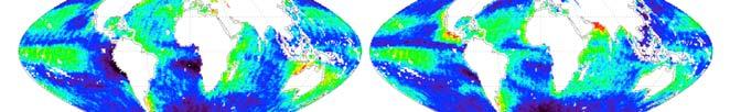
7 Climatology of wind speed under all type of cloud conditions Global monthly average wind speed varies from 1 2 m/s up to 15 m/s ESMWF wind speed (m/s)


")
8 Climatology of wind speed under cloud and haze free conditions Global monthly average wind speed varies from 1 2 m/s up to 15 m/s ESMWF wind speed (m/s)
9 Wind speed selection for sun glint extent estimation. First level of precision: global wind speed value Mean Wind Speed Standard deviation up to now 7.5 m/s global value from the study 7.15 m/s 3.38 m/s global value from the study UNDER CLOUD_HAZE FREE CONDITIONS 6.72 m/s 3.22 m/s
10 Wind speed selection for sun glint extent estimation. Second level of precision: Average wind speed over latitudinal bands
11 Wind speed selection for sun glint extent estimation. Second level of precision: Average wind speed over latitudinal bands


12 Wind speed selection for sun glint extent estimation. Monthly averaged wind speed under cloud free conditions appears to be lower than in all kind of cloud conditions from 50 south to 50 North
13 Wind speed selection for sun glint extent estimation. Third level of precision: 50x50 km monthly averaged wind speed under cloud_haze_free conditions ESMWF wind speed (m/s)
14 Wind speed selection for sun glint extent estimation. A coverage analysis is carried out, based on real wind speed data (cloud free conditions) satellite/ Sun geometry simulations Cox Munk model Estimation of the phase-a Sentinel 3 swath decrease sensitivity to wind speed Equator, September 21 WS = 7 m/s WS= 6 m/s WS= 5 m/s

15 Coverage simulations for Phase A Sentinel 3 Cox-Munk model Real WS data + Satellite/Sun geometry
16 Coverage simulations for Phase A Sentinel 3

17 Coverage simulations for Phase A Sentinel 3
18 Coverage simulations for Phase A Sentinel 3


19 Coverage simulations for Phase A Sentinel 3 geometrical coverage simulations for Sentinel 3 Number of valid observations per month


20 Coverage simulations for Phase A Sentinel 3 Effective coverage simulations for Sentinel 3: (clouds + sun glint)


21 Coverage simulations for Phase A Sentinel 3
22 Conclusions A new climatology of global ocean wind speed under cloud free and all kind of cloud conditions has been processed. This can be used for: Improvement of accuracy on the estimation of sun glint extent impact during the early definition of Remote Sensing ocean optical instruments and missions. Improvement on the worldwide estimation the coverage taking into account sun glint and clouds. Early assessment on temporal expected distribution of products. More accurate information to optimize instrument and mission design during the very early project phases
23 Acknowledgments We would like to thank the G POD team in ESRIN, in particular to Olivier Colin, Miguel Angel Rubio and Emmanuel Mathot for providing us with a well appreciated amount of support and flexibility. Marc Bouvet, Jean Paul Huot, Steven Delwart, and Jean Loup Bézy for their consistent support and expertise on a wide range of technical aspects.


24 THANK YOU
Minutes of the First Meeting. of the IOCCG Working Group. L1 Requirements for Ocean-Colour Remote Sensing. April 20-21, 2010
 Minutes of the First Meeting of the IOCCG Working Group L1 Requirements for Ocean-Colour Remote Sensing April 20-21, 2010 Bethesda, Maryland (Washington, D.C.), USA Participants: - Charles R. McClain (chair,
Sentinel-3 Sea and Land Surface Temperature Radiometer (SLSTR) Mireya Etxaluze (STFC RAL Space)
 Mireya Etxaluze (STFC RAL Space)") Sentinel-3 Sea and Land Surface Temperature Radiometer (SLSTR) Mireya Etxaluze (STFC RAL Space) RAL Space Radiometry Group Dave Smith Mireya Etxaluze, Ed Polehampton, Caroline Cox, Tim Nightingale, Dan
Sentinel-3 Sea and Land Surface Temperature Radiometer (SLSTR) Mireya Etxaluze (STFC RAL Space) RAL Space Radiometry Group Dave Smith Mireya Etxaluze, Ed Polehampton, Caroline Cox, Tim Nightingale, Dan
EXPLOITING SUNGLINT SIGNATURES FROM MERIS AND MODIS IMAGERY IN COMBINATION TO SAR DATA TO DETECT OIL SLICKS
 EXPLOITING SUNGLINT SIGNATURES FROM MERIS AND MODIS IMAGERY IN COMBINATION TO SAR DATA TO DETECT OIL SLICKS M. Adamo 1, G. De Carolis 2, V. De Pasquale 2, and G. Pasquariello 2 1 Dept. of Physics, University
Detection of ship NO 2 emissions over Europe from satellite observations
 Detection of ship NO 2 emissions over Europe from satellite observations Huan Yu DOAS seminar 24 April 2015 Ship Emissions to Atmosphere Reporting Service (SEARS project) Outline Introduction Shipping
(A)ATSR and SLSTR VIS/SWIR Channels Calibration
ATSR and SLSTR VIS/SWIR Channels Calibration") (A)ATSR and SLSTR VIS/SWIR Channels Calibration Dave Smith & Mireya Etxaluze 2017 RAL Space 1 ATSR Series 1991-2000 ATSR-1 1995-2008 ATSR-2 2002-2012- AATSR 2 SLSTR Series 2016 Sentinel 3A 2018 Sentinel
(A)ATSR and SLSTR VIS/SWIR Channels Calibration Dave Smith & Mireya Etxaluze 2017 RAL Space 1 ATSR Series 1991-2000 ATSR-1 1995-2008 ATSR-2 2002-2012- AATSR 2 SLSTR Series 2016 Sentinel 3A 2018 Sentinel
Sentinel 2 Pre-processing Requirements for coastal and inland waters
 Sentinel 2 Pre-processing Requirements for coastal and inland waters K A I S Ø R E NSEN NIVA CARSTEN B R O CKMANN Ecological and chemical classification of water bodies in Norway Water quality - products
Calibration of MERIS on ENVISAT Status at End of 2002
 Calibration of MERIS on ENVISAT Status at End of 2002 Bourg L. a, Delwart S. b, Huot J-P. b a ACRI-ST, 260 route du Pin Montard, BP 234, 06904 Sophia-Antipolis Cedex, France b ESA/ESTEC, P.O. Box 299,
A unified, global aerosol dataset from MERIS, (A)ATSR and SEVIRI
ATSR and SEVIRI") A unified, global aerosol dataset from MERIS, and SEVIRI Gareth Thomas gthomas@atm.ox.ac.uk Introduction GlobAEROSOL is part of the ESA Data User Element programme. It aims to provide a global aerosol
A unified, global aerosol dataset from MERIS, and SEVIRI Gareth Thomas gthomas@atm.ox.ac.uk Introduction GlobAEROSOL is part of the ESA Data User Element programme. It aims to provide a global aerosol
Carsten Brockmann, Ana Ruescas, Simon Pinnock CoastColour Team: BC D, HZG D, PML UK, RBINS B, LISE F, FCUL P COASTCOLOUR SPOT 4 TAKE 5
 Carsten Brockmann, Ana Ruescas, Simon Pinnock CoastColour Team: BC D, HZG D, PML UK, RBINS B, LISE F, FCUL P COASTCOLOUR SPOT 4 TAKE 5 CoastColour CoastColour is providing ocean colour products for coastal
Arctic Weather Every 10 Minutes: Design & Operation of ABI for PCW
 Arctic Weather Every 10 Minutes: Design and Operation of ABI for PCW Dr. Paul C. Griffith and Sue Wirth 31st Space Symposium, Technical Track, Colorado Springs, Colorado This document is not subject to
Long-Term Time Series of Water Vapour Total Columns from GOME, SCIAMACHY and GOME-2
 Graphics: ESA Graphics: ESA Graphics: ESA Long-Term Time Series of Water Vapour Total Columns from GOME, SCIAMACHY and GOME-2 S. Noël, S. Mieruch, H. Bovensmann, J. P. Burrows Institute of Environmental
Atmospheric correction in presence of sun glint: the POLYMER Algorithm
 Atmospheric correction in presence of sun glint: the POLYMER Algorithm Dominique Jolivet François Steinmetz Pierre-Yves Deschamps Jan 17, 2011 Atelier National Couleur de l'eau - GIS COOC c 2011 Atmospheric
Ivana Zinno, Francesco Casu, Claudio De Luca, Riccardo Lanari, Michele Manunta. CNR IREA, Napoli, Italy
 An Unsupervised Implementation of the P-SBAS DiNSAR Algorithm for Processing Large Data Volumes through Distributed Computing Infrastructures within Operational Environments Ivana Zinno, Francesco Casu,
ESA Climate Change Initiative (CCI)
") ESA Climate Change Initiative (CCI) New ESA Programme with the aim to contribute to worldwide efforts to generate Essential Climate Variables (ECVs) C. Zehner Barcelona, 07/09/2009 Two climate action paths
ESA Climate Change Initiative (CCI) New ESA Programme with the aim to contribute to worldwide efforts to generate Essential Climate Variables (ECVs) C. Zehner Barcelona, 07/09/2009 Two climate action paths
Spectral surface albedo derived from GOME-2/Metop measurements
 Spectral surface albedo derived from GOME-2/Metop measurements Bringfried Pflug* a, Diego Loyola b a DLR, Remote Sensing Technology Institute, Rutherfordstr. 2, 12489 Berlin, Germany; b DLR, Remote Sensing
In-flight Calibration Techniques Using Natural Targets. CNES Activities on Calibration of Space Sensors
 In-flight Calibration Techniques Using Natural Targets CNES Activities on Calibration of Space Sensors Bertrand Fougnie, Patrice Henry (DCT/SI, CNES, Toulouse, France) In-flight Calibration using Natural
Meteosat Third Generation (MTG): Lightning Imager and its products Jochen Grandell
: Lightning Imager and its products Jochen Grandell") 1 Go to View menu and click on Slide Master to update this footer. Include DM reference, version number and date Meteosat Third Generation (MTG): Lightning Imager and its products Jochen Grandell Topics
1 Go to View menu and click on Slide Master to update this footer. Include DM reference, version number and date Meteosat Third Generation (MTG): Lightning Imager and its products Jochen Grandell Topics
Satellite remote sensing of aerosols & clouds: An introduction
 Satellite remote sensing of aerosols & clouds: An introduction Jun Wang & Kelly Chance April 27, 2006 junwang@fas.harvard.edu Outline Principals in retrieval of aerosols Principals in retrieval of water
Hyperspectral Atmospheric Correction
 Hyperspectral Atmospheric Correction Bo-Cai Gao June 2015 Remote Sensing Division Naval Research Laboratory, Washington, DC USA BACKGROUND The concept of imaging spectroscopy, or hyperspectral imaging,
Using MERIS and MODIS for Land Cover Mapping in the Netherlands
 Using MERIS and for Land Cover Mapping in the Netherlands Raul Zurita Milla, Michael Schaepman and Jan Clevers Wageningen University, Centre for Geo-Information, NL Introduction Actual and reliable information
EUMETSAT Activities Related to Climate
 EUMETSAT Activities Related to Climate Jörg Schulz joerg.schulz@eumetsat.int Slide: 1 What we do USER REQUIREMENTS European National Meteorological Services Operating Agency! European Space Industry Private
Arctic Regional Ocean Observing System Arctic ROOS Report from 2012
 Arctic Regional Ocean Observing System Arctic ROOS Report from 2012 By Stein Sandven Nansen Environmental and Remote Sensing Center (www.arctic-roos.org) Focus in 2012 1. Arctic Marine Forecasting Center
Climate data records from OSI SAF scatterometer winds. Anton Verhoef Jos de Kloe Jeroen Verspeek Jur Vogelzang Ad Stoffelen
 Climate data records from OSI SAF scatterometer winds Anton Verhoef Jos de Kloe Jeroen Verspeek Jur Vogelzang Ad Stoffelen Outline Motivation Planning Preparation and methods Quality Monitoring Output
Atmospheric Lidar The Atmospheric Lidar (ATLID) is a high-spectral resolution lidar and will be the first of its type to be flown in space.
 is a high-spectral resolution lidar and will be the first of its type to be flown in space.") www.esa.int EarthCARE mission instruments ESA s EarthCARE satellite payload comprises four instruments: the Atmospheric Lidar, the Cloud Profiling Radar, the Multi-Spectral Imager and the Broad-Band Radiometer.
www.esa.int EarthCARE mission instruments ESA s EarthCARE satellite payload comprises four instruments: the Atmospheric Lidar, the Cloud Profiling Radar, the Multi-Spectral Imager and the Broad-Band Radiometer.
SSS retrieval from space Comparison study using Aquarius and SMOS data
 44 th International Liège Colloquium on Ocean Dynamics 7-11 May 2012 SSS retrieval from space Comparison study using Aquarius and SMOS data Physical Oceanography Department Institute of Marine Sciences
COPERNICUS SPACE DATA OFFER FOR PUBLIC AUTHORITIES DISTRIBUTED BY ESA
 COPERNICUS SPACE DATA OFFER FOR PUBLIC AUTHORITIES DISTRIBUTED BY ESA The Copernicus Space Component Data Access (CSC-DA) service - financed by the EU and operated by ESA - grants National Public Authorities
Proceedings of the Second Working Meeting on MERIS and AATSR Calibration and Geophysical Validation (MAVT-2006)
") SP-615 July 2006 Proceedings of the Second Working Meeting on MERIS and AATSR Calibration and Geophysical Validation (MAVT-2006) 20-24 March 2006 ESRIN, Frascati, Italy MAVT-2006 Organising Committee Carmen
SP-615 July 2006 Proceedings of the Second Working Meeting on MERIS and AATSR Calibration and Geophysical Validation (MAVT-2006) 20-24 March 2006 ESRIN, Frascati, Italy MAVT-2006 Organising Committee Carmen
Sentinel-3A Product Notice SLSTR Level-2 Sea Surface Temperature
 Sentinel-3A Product Notice SLSTR Level-2 Sea Surface Temperature Mission Sensor Product Sentinel-3A SLSTR Level 2 Sea Surface Temperature Product Notice ID EUM/OPS-SEN3/DOC/18/984462 S3A.PN-SLSTR-L2M.003
We greatly appreciate the thoughtful comments from the reviewers. According to the reviewer s comments, we revised the original manuscript.
 Response to the reviews of TC-2018-108 The potential of sea ice leads as a predictor for seasonal Arctic sea ice extent prediction by Yuanyuan Zhang, Xiao Cheng, Jiping Liu, and Fengming Hui We greatly
Cloud screening and snow detection with MERIS. Rene Preusker, Jürgen Fischer, Carsten Brockmann, Marco Zühlke, Uwe krämer, Anja Hünerbein
 Cloud screening and snow detection with MERIS Rene Preusker, Jürgen Fischer, Carsten Brockmann, Marco Zühlke, Uwe krämer, Anja Hünerbein Prelude The following algorithm has been compiled in the frame of
SYNERGY OF MERIS/ASAR FOR OBSERVING MARINE FILM SLICKS AND SMALL SCALE PROCESSES.
 SYNERGY OF MERIS/ASAR FOR OBSERVING MARINE FILM SLICKS AND SMALL SCALE PROCESSES. J.C.B. da Silva (1), S. Correia (1), S.A. Ermakov (), I. A. Sergievskaya () and I.S. Robinson (3) (1) Department of Physics
Land Cover and Asset Mapping Operational Change Detection
 Land Cover and Asset Mapping Operational Change Detection Andreas Müller DLR DFD with the support of Charly Kaufmann, Allan Nielsen, Juliane Huth ESA Oil & Gas Workshop, 13-14 September 2010 Folie 1 TWOPAC
Current Application of Vicarious Calibration for Geostationary Ocean Color Imager (GOCI) DATA
 DATA") Current Application of Vicarious Calibration for Geostationary Ocean Color Imager (GOCI) DATA On behalf of Jae-Hyun Ahn & Young-je Park, Seongick CHO(Secondment at Astrium SAS, France) Korea Ocean Satellite
Current Application of Vicarious Calibration for Geostationary Ocean Color Imager (GOCI) DATA On behalf of Jae-Hyun Ahn & Young-je Park, Seongick CHO(Secondment at Astrium SAS, France) Korea Ocean Satellite
Status of Libya-4 Activities - RAL
 Status of Libya-4 Activities - RAL Dr David L Smith Preparation for reprocessing AATSR Long term drift correction LUT version 2.09 implemented in reprocessing V3.00 available based on revised BRF modelling
CNES Activity Report. Patrice Henry - CNES WGCV Plenary # 41 Tokyo Sept. 5-7, Working Group on Calibration and Validation
 Activity Report Patrice Henry - Tokyo Sept. 5-7, 2016 Working Group on Calibration and Validation SUMMARY Calibration Monitoring of in-flight Missions Preparation of future Missions Involvement in CEOS/WGCV
Applications of Data Assimilation in Earth System Science. Alan O Neill Data Assimilation Research Centre University of Reading
 Applications of Data Assimilation in Earth System Science Alan O Neill Data Assimilation Research Centre University of Reading DARC Current & Future Satellite Coverage Formation Flying - Afternoon Constellation
Landcover Dynamics in the Niger Inland Delta (Mali)
") Fakultät Forst-, Geo- Hydrowissenschaften Institut f. Photogrammetrie & Fernerkundung, Professur Fernerkundung Landcover Dynamics in the Niger Inland Delta (Mali) A Classification Approach for MERIS Data
Fakultät Forst-, Geo- Hydrowissenschaften Institut f. Photogrammetrie & Fernerkundung, Professur Fernerkundung Landcover Dynamics in the Niger Inland Delta (Mali) A Classification Approach for MERIS Data
A Method for MERIS Aerosol Correction : Principles and validation. David Béal, Frédéric Baret, Cédric Bacour, Kathy Pavageau
 A Method for MERIS Aerosol Correction : Principles and validation David Béal, Frédéric Baret, Cédric Bacour, Kathy Pavageau Outlook Objectives Principles Training neural networks Validation Comparison
ESA Climate Change Initiative
 ESA Climate Change Initiative Olivier Arino Frascati, 23 June 2009 Climate Change Initiative Rationale Two climate action paths GCOS-82 in 2003 GCOS-92 in 2004 GCOS-107 in 2006 CEOS response 2006 GEOSS
China France. Oceanography S A T. The CFOSAT project. e l l i t e. C. Tison (1), D. Hauser (2), A. Mouche (3) CNES, France (2)
, D. Hauser (2), A. Mouche (3) CNES, France (2)") China France The CFOSAT project C. Tison (1), D. Hauser (2), A. Mouche (3) (1) CNES, France (2) OVSQ, CNRS, LATMOS-IPSL, France (3) IFREMER, LOS, France celine.tison@cnes.fr Oceanography S A T e l l i
China France The CFOSAT project C. Tison (1), D. Hauser (2), A. Mouche (3) (1) CNES, France (2) OVSQ, CNRS, LATMOS-IPSL, France (3) IFREMER, LOS, France celine.tison@cnes.fr Oceanography S A T e l l i
Cloud masking as cross-cutting issue
 Cloud masking as cross-cutting issue Presentation to CEOS/WGCV activity project planning meeting Rainer Hollmann, Cornelia Schlundt, Satellite based Climate Monitoring Deutscher Wetterdienst Outline Need
Physical Model to Describe the PARASOL Radiometric Trending. Definition, Adjustment, and Validation
 Physical Model to Describe the PARASOL Radiometric Trending Definition, Adjustment, and Validation Bertrand Fougnie CNES CALCON 13 Summary The PARASOL instrument & mission Evidences a of radiometric drift
FLEX MISSION: FLORIS Instrument
 FLEX MISSION: FLORIS Instrument Primo Workshop su Data Exploitation della missione PRISMA, precursore delle missioni iperspettrali nazionali ASI Roma, 2 Marzo 2017 An ESA Earth Explorer Mission to observe
ESSReS-L4: 17 Aug 20 Aug, 2009 Introduction to the interdisciplinary field of Earth System Science Research, Part IV
 ESSReS-L4: 17 Aug 20 Aug, 2009 Introduction to the interdisciplinary field of Earth System Science Research, Part IV Physics and Chemistry of the Atmosphere, Remote Sensing and Phytooptics 2 Editor in
Read-me-first note for the release of the SMOS level 2 Soil Moisture data products
 Read-me-first note for the release of the SMOS level 2 Soil Moisture data products Processor version Release date by ESA Authors Further information Contact for helpline Comments to ESL Level 2 soil moisture
Preparation and dissemination of the averaged maps and fields of selected satellite parameters for the Black Sea within the SeaDataNet project
 Journal of Environmental Protection and Ecology 11, No 4, 1568 1578 (2010) Environmental informatics Preparation and dissemination of the averaged maps and fields of selected satellite parameters for the
USE OF ENVISAT AATSR WITHIN THE GODAE HIGH RESOLUTION SST PILOT PROJECT (GHRSST-PP).
.") USE OF ENVISAT AATSR WITHIN THE GODAE HIGH RESOLUTION SST PILOT PROJECT (GHRSST-PP). Craig Donlon (1) (1) International GHRSSTPP Project Office, Met Office Hadley Centre, FitzRoy Road, Exeter, (United
USE OF ENVISAT AATSR WITHIN THE GODAE HIGH RESOLUTION SST PILOT PROJECT (GHRSST-PP). Craig Donlon (1) (1) International GHRSSTPP Project Office, Met Office Hadley Centre, FitzRoy Road, Exeter, (United
Geophysical Correction Application in Level 2 CryoSat Data Products
 ESRIN-EOP-GQ / IDEAS IDEAS-VEG-IPF-MEM-1288 Version 2.0 29 July 2014 Geophysical Correction Application in Level 2 CryoSat Data Products TABLE OF CONTENTS 1 INTRODUCTION... 3 1.1 Purpose and Scope... 3
Aerosols from Sentinel 3 and EarthCARE missions
 Aerosols from Sentinel 3 and EarthCARE missions Michael Eisinger, Tobias Wehr, Dulce Lajas, Alain Lefebvre European Space Agency Aerosol Observability Workshop 27-29 April 2010 Monterey, CA Page 1 Outline
ASSESSMENT OF DIFFERENT WATER STRESS INDICATORS BASED ON EUMETSAT LSA SAF PRODUCTS FOR DROUGHT MONITORING IN EUROPE
 ASSESSMENT OF DIFFERENT WATER STRESS INDICATORS BASED ON EUMETSAT LSA SAF PRODUCTS FOR DROUGHT MONITORING IN EUROPE G. Sepulcre Canto, A. Singleton, J. Vogt European Commission, DG Joint Research Centre,
In-flight Evaluation of the SPOT-6 Radiometric Calibration based on Acquisitions over Natural Targets and Automated in-situ Measurements
 In-flight Evaluation of the SPOT-6 Radiometric Calibration based on Acquisitions over Natural Targets and Automated in-situ Measurements Philippe GAMET, Bertrand FOUGNIE, Sophie LACHERADE (CNES), Mathieu
Aerosol forecasting and assimilation at ECMWF: overview and data requirements
 Aerosol forecasting and assimilation at ECMWF: overview and data requirements Angela Benedetti Luke Jones ECMWF Acknowledgements: Jean-Jacques Morcrette, Carole Peubey, Olaf Stiller, and Richard Engelen
In-flight Spectral Calibration of MERIS/OLCI. Jürgen Fischer, Rene Preusker, Rasmus Lindstrot Institute for Space Science Free University Berlin
 In-flight Spectral Calibration of MERIS/OLCI Jürgen Fischer, Rene Preusker, Rasmus Lindstrot Institute for Space Science Free University Berlin 1 MERIS Instrument 2 MERIS Instrument Concept 3 MERIS Operation
Sentinel-5 Precursor: Preparing the first Copernicus Atmospheric Mission
 Sentinel-5 Precursor: Preparing the first Copernicus Atmospheric Mission Herbert Nett 1, Kevin McMullan 1, Paul Ingmann 1, Thorsten Fehr 2 (1) ESA/ESTEC, Keplerlaan 1, NL-2201 AZ Noordwijk (2) ESA/ESRIN,
Improving Sea Surface Microwave Emissivity Model for Radiance Assimilation
 Improving Sea Surface Microwave Emissivity Model for Radiance Assimilation Quanhua (Mark) Liu 1, Steve English 2, Fuzhong Weng 3 1 Joint Center for Satellite Data Assimilation, Maryland, U.S.A 2 Met. Office,
SMALL SCALE PROCESSES IN THE SOUTH ATLANTIC OBSERVED IN SYNERGY OF ATSR AND SAR DATA DURING THE TANDEM MISSION
 SMALL SCALE PROCESSES IN THE SOUTH ATLANTIC OBSERVED IN SYNERGY OF ATSR AND SAR DATA DURING THE TANDEM MISSION Ian S Robinson, Joseph Allison School of Ocean and Earth Science Southampton Oceanography
Surface UV Irradiance from OMI on EOS Aura. Atmospheric Science Conference ESRIN, 8-12 May 2006 Aapo Tanskanen
 Surface UV Irradiance from OMI on EOS Aura Atmospheric Science Conference ESRIN, 8-12 May 2006 Aapo Tanskanen Contents OMI Surface UV Algorithm N. Krotkov /GEST Center, University of Maryland J. Herman
A Time Series of Photo-synthetically Available Radiation at the Ocean Surface from SeaWiFS and MODIS Data
 A Time Series of Photo-synthetically Available Radiation at the Ocean Surface from SeaWiFS and MODIS Data Robert Frouin* a, John McPherson a, Kyozo Ueyoshi a, Bryan A. Franz b a Scripps Institution of
Cloud detection using SEVIRI IR channels
 Cloud detection using SEVIRI IR channels Alessandro.Ipe@oma.be & Luis Gonzalez Sotelino Royal Meteorological Institute of Belgium GERB Science Team Meeting @ London September 9 10 2009 1 / 19 Overview
IASI L2Pcore sea surface temperature. By Anne O Carroll, Thomas August, Pierre Le Borgne and Anne Marsouin
 IASI L2Pcore sea surface temperature By Anne O Carroll, Thomas August, Pierre Le Borgne and Anne Marsouin Abstract Anne O Carroll EUMETSAT Eumetsat Allee 1 64295 Darmstadt Germany Tel: +49 6151 807 676
C o p e r n i c u s a n d W I G O S
 C o p e r n i c u s a n d W I G O S Jean-Noël Thépaut & Mark Dowell 24 October 2017 GEO XIV, Washington DC, 23-28 October 2017 T h e C o p e r n i c u s P r o g r a m m e Copernicus is the European Union
The Copernicus Sentinel-5 Mission: Daily Global Data for Air Quality, Climate and Stratospheric Ozone Applications
 SENTINEL-5 The Copernicus Sentinel-5 Mission: Daily Global Data for Air Quality, Climate and Stratospheric Ozone Applications Yasjka Meijer RHEA for ESA, Noordwijk, NL 15/04/2016 Co-Authors: Jörg Langen,
Evaluation of Regressive Analysis Based Sea Surface Temperature Estimation Accuracy with NCEP/GDAS Data
 Evaluation of Regressive Analysis Based Sea Surface Temperature Estimation Accuracy with NCEP/GDAS Data Kohei Arai 1 Graduate School of Science and Engineering Saga University Saga City, Japan Abstract
MERIS SURFACE PRESSURE AND CLOUD FLAG: PRESENT STATUS AND IMPROVEMENTS
 ABSTRACT MERIS SURFACE PRESSURE AND CLOUD FLAG: PRESENT STATUS AND IMPROVEMENTS D. Ramon (1), R. Santer (2), P. Dubuisson (2) (1) HYGEOS, 191 rue N. Appert, 59650 Villeneuve d Ascq, FRANCE, dr@hygeos.com
Presentation of met.no s experience and expertise related to high resolution reanalysis
 Presentation of met.no s experience and expertise related to high resolution reanalysis Oyvind Saetra, Ole Einar Tveito, Harald Schyberg and Lars Anders Breivik Norwegian Meteorological Institute Daily
EVALUATION OF MERIS AEROSOL PRODUCTS FOR NATIONAL AND REGIONAL AIR QUALITY IN AUSTRIA
 EVALUATION OF MERIS AEROSOL PRODUCTS FOR NATIONAL AND REGIONAL AIR QUALITY IN AUSTRIA Robert Höller (1),*, Christian Nagl (1), Herbert Haubold (1), Ludovic Bourg (2), Odile Fanton d Andon (2), and Philippe
CNES WGCV-36 Report Cal/Val Activities
 CEOS WGCV Meeting 13-17th May 2013, Shangai, China CNES WGCV-36 Report Cal/Val Activities Bertrand Fougnie, Sophie Lachérade, Denis Jouglet, Eric Péquignot, Aimé Meygret, Patrice Henry CNES 1 Summary Pleiades
S3-A OLCI Cyclic Performance Report. Cycle No Start date: 03/09/2017. End date: 30/09/2017
 PREPARATION AND OPERATIONS OF THE MISSION PERFORMANCE CENTRE (MPC) FOR THE COPERNICUS SENTINEL-3 MISSION Start date: 03/09/2017 End date: 30/09/2017 Contract: 4000111836/14/I-LG Customer: ESA Document
Obs4MIPs - Satellite Observations Rehosted for GCM Model Evaluation
 Obs4MIPs - Satellite Observations Rehosted for GCM Model Evaluation Obs4MIPs Robert Ferraro Jet Propulsion Laboratory This project is collaboration between NASA and DOE, and is overseen by an International
C o p e r n i c u s L a n d M o n i t o r i n g S e r v i c e
 C o p e r n i c u s L a n d M o n i t o r i n g S e r v i c e Integration into existing Snow and Ice Services and draft product specifications Annett BARTSCH b.geos Copernicus High Resolution Snow and
ASSESSMENT OF THE UNCERTAINTY OF ATMOSPHERIC SCATTERING FUNCTIONS USED IN MERIS ATMOSPHERIC CORRECTION OVER WATER.
 ASSESSMENT OF THE UNCERTAINTY OF ATMOSPHERIC SCATTERING FUNCTIONS USED IN MERIS ATMOSPHERIC CORRECTION OVER WATER Francis Zagolski Motivations Ø Contribute to the MERIS validation of L2 optical parameters
Antarctic Ice Sheet cci. Anna Hogg
 Antarctic Ice Sheet cci Anna Hogg Overview 1.Project Summary and Status 2.AIS cci Products Surface Elevation Change Gravimetry Mass Balance Ice Velocity Grounding Line Location 3.Climate Assessment 4.AIS
The DEIMOS Earth Observation System and the PanGeo Alliance. Contribution to CSCDA Data WareHouse 2. Fabrizio Pirondini CEO, Elecnor Deimos Imaging
 The DEIMOS Earth Observation System and the PanGeo Alliance Contribution to CSCDA Data WareHouse 2 Fabrizio Pirondini CEO, Elecnor Deimos Imaging Copernicus Space Component Data Access Workshop ESRIN,
Sub-seasonal predictions at ECMWF and links with international programmes
 Sub-seasonal predictions at ECMWF and links with international programmes Frederic Vitart and Franco Molteni ECMWF, Reading, U.K. Using ECMWF forecasts, 4-6 June 2014 1 Outline Recent progress and plans
Product Notice ID. OL_2_LFR in NRT and NTC OL_2_LRR in NRT and NTC. Product. Issue/Rev Date 25/01/2019 Version 1.0
 S3 Product Notice OLCI Mission Sensor Product & OLCI OL_2_LFR in NRT and NTC OL_2_LRR in NRT and NTC Product Notice ID S3.PN-OLCI-L2L.02 Issue/Rev Date 25/01/2019 Version 1.0 Preparation This Product Notice
The VENμS mission: Earth Observation with High Spatial and Temporal Resolution Capabilities
 Ben Gurion University The VENμS mission: Earth Observation with High Spatial and Temporal Resolution Capabilities G. Dedieu 1, O. Hagolle 2, A. Karnieli 3, S. Cherchali 2 P. Ferrier 2 and Y. Yaniv 4 1
EXTRACTION OF THE DISTRIBUTION OF YELLOW SAND DUST AND ITS OPTICAL PROPERTIES FROM ADEOS/POLDER DATA
 EXTRACTION OF THE DISTRIBUTION OF YELLOW SAND DUST AND ITS OPTICAL PROPERTIES FROM ADEOS/POLDER DATA Takashi KUSAKA, Michihiro KODAMA and Hideki SHIBATA Kanazawa Institute of Technology Nonoichi-machi
Long-term global time series of MODIS and VIIRS SSTs
 Long-term global time series of MODIS and VIIRS SSTs Peter J. Minnett, Katherine Kilpatrick, Guillermo Podestá, Yang Liu, Elizabeth Williams, Susan Walsh, Goshka Szczodrak, and Miguel Angel Izaguirre Ocean
OCEAN & SEA ICE SAF CDOP2. OSI-SAF Metop-A IASI Sea Surface Temperature L2P (OSI-208) Validation report. Version 1.4 April 2015
 Validation report. Version 1.4 April 2015") OCEAN & SEA ICE SAF CDOP2 OSI-SAF Metop-A IASI Sea Surface Temperature L2P (OSI-208) Validation report Version 1.4 April 2015 A. O Carroll and A. Marsouin EUMETSAT, Eumetsat-Allee 1, Darmstadt 64295, Germany
OCEAN & SEA ICE SAF CDOP2 OSI-SAF Metop-A IASI Sea Surface Temperature L2P (OSI-208) Validation report Version 1.4 April 2015 A. O Carroll and A. Marsouin EUMETSAT, Eumetsat-Allee 1, Darmstadt 64295, Germany
Atmospheric Correction
 NOWPAP / PICES / WESTPAC Joint Training Course on Remote Sensing Data Analysis Introduction and recent progress in ocean color remote sensing part II: Correction of the influence of the atmosphere in Ocean
Sentinel-2 and Sentinel-3 absolute calibration monitoring. C. Desjardins & V. Lonjou CNES
 Sentinel-2 and Sentinel-3 absolute calibration monitoring C. Desjardins & V. Lonjou CNES Radiometric S2A Calibration RRQI, 28 January Workshop, 2016, 30-31/08/2017 CNES SUMMARY CALCON Aug 22-25 2017 VICARIOUS
Development of spatial intercomparison within the operational wave forecast verification exchange
 Development of spatial intercomparison within the operational wave forecast verification exchange Adrian Hines, Met Office / JCOMM Jean-Michel Lefèvre, Météo-France / JCOMM Dave Poulter, National Oceanography
Simulated Radiances for OMI
 Simulated Radiances for OMI document: KNMI-OMI-2000-004 version: 1.0 date: 11 February 2000 author: J.P. Veefkind approved: G.H.J. van den Oord checked: J. de Haan Index 0. Abstract 1. Introduction 2.
Wave-DDS and Pilot Wave Forecast Verification Scheme Extension
 Wave-DDS and Pilot Wave Forecast Verification Scheme Extension David Poulter, National Oceanography Centre GlobWave 2010. All rights reserved The Globwave Wave-DDS and PS-WFVS The GlobWave Diagnostic Systems
IMPORTANCE OF SATELLITE DATA (FOR REANALYSIS AND BEYOND) Jörg Schulz EUMETSAT
 Jörg Schulz EUMETSAT") IMPORTANCE OF SATELLITE DATA (FOR REANALYSIS AND BEYOND) Jörg Schulz EUMETSAT Why satellite data for climate monitoring? Global coverage Global consistency, sometimes also temporal consistency High spatial
IMPORTANCE OF SATELLITE DATA (FOR REANALYSIS AND BEYOND) Jörg Schulz EUMETSAT Why satellite data for climate monitoring? Global coverage Global consistency, sometimes also temporal consistency High spatial
OCEAN SURFACE DRIFT BY WAVELET TRACKING USING ERS-2 AND ENVISAT SAR IMAGES
 OCEAN SURFACE DRIFT BY WAVELET TRACKING USING ERS-2 AND ENVISAT SAR IMAGES Antony K. Liu, Yunhe Zhao Ocean Sciences Branch, NASA Goddard Space Flight Center, Greenbelt, Maryland, USA Ming-Kuang Hsu Northern
NASA's Plankton, Aerosol, Cloud, ocean Ecosystem (PACE) mission update
 mission update") NASA's Plankton, Aerosol, Cloud, ocean Ecosystem (PACE) mission update Antonio Mannino1, Jeremy Werdell1, Brian Cairns2 NASA GSFC1 and GISS2 Acknowledgments: PACE Team https://pace.gsfc.nasa.gov 1 Outline
NASA's Plankton, Aerosol, Cloud, ocean Ecosystem (PACE) mission update Antonio Mannino1, Jeremy Werdell1, Brian Cairns2 NASA GSFC1 and GISS2 Acknowledgments: PACE Team https://pace.gsfc.nasa.gov 1 Outline
Soleksat. a flexible solar irradiance forecasting tool using satellite images and geographic web-services
 Soleksat a flexible solar irradiance forecasting tool using satellite images and geographic web-services Sylvain Cros, Mathieu Turpin, Caroline Lallemand, Quentin Verspieren, Nicolas Schmutz They support
Experiences of using ECV datasets in ECMWF reanalyses including CCI applications. David Tan and colleagues ECMWF, Reading, UK
 Experiences of using ECV datasets in ECMWF reanalyses including CCI applications David Tan and colleagues ECMWF, Reading, UK Slide 1 Main points Experience shows benefit of integrated & iterative approach
The benefits and developments in ensemble wind forecasting
 The benefits and developments in ensemble wind forecasting Erik Andersson Slide 1 ECMWF European Centre for Medium-Range Weather Forecasts Slide 1 ECMWF s global forecasting system High resolution forecast
Geoscience Australia Report on Cal/Val Activities
 Medhavy Thankappan Geoscience Australia Agency Report I Berlin May 6-8, 2015 Outline 1. Calibration / validation at Geoscience Australia Corner reflector infrastructure for SAR calibration (for information)
GEOG Lecture 8. Orbits, scale and trade-offs
 Environmental Remote Sensing GEOG 2021 Lecture 8 Orbits, scale and trade-offs Orbits revisit Orbits geostationary (36 000 km altitude) polar orbiting (200-1000 km altitude) Orbits revisit Orbits geostationary
Remote sensing of sea ice
 Remote sensing of sea ice Ice concentration/extent Age/type Drift Melting Thickness Christian Haas Remote Sensing Methods Passive: senses shortwave (visible), thermal (infrared) or microwave radiation
OSI SAF Sea Ice products
 OSI SAF Sea Ice products Lars-Anders Brevik, Gorm Dybkjær, Steinar Eastwood, Øystein Godøy, Mari Anne Killie, Thomas Lavergne, Rasmus Tonboe, Signe Aaboe Norwegian Meteorological Institute Danish Meteorological
Jay Lawrimore NOAA National Climatic Data Center 9 October 2013
 Jay Lawrimore NOAA National Climatic Data Center 9 October 2013 Daily data GHCN-Daily as the GSN Archive Monthly data GHCN-Monthly and CLIMAT messages International Surface Temperature Initiative Global
Eight Years MOS-IRS Summary of Calibration Activities
 Eight Years MOS-IRS Summary of Calibration Activities Workshop on Inter-Comparison of Large Scale Optical and Infrared Sensors 12 14 October 2004, ESA / ESTEC Noordwijk, The Netherlands Horst Schwarzer,
ADVANCEMENTS IN SNOW MONITORING
 Polar Space Task Group ADVANCEMENTS IN SNOW MONITORING Thomas Nagler, ENVEO IT GmbH, Innsbruck, Austria Outline Towards a pan-european Multi-sensor Snow Product SnowPEx Summary Upcoming activities SEOM
Ocean currents from altimetry
 Ocean currents from altimetry Pierre-Yves LE TRAON - CLS - Space Oceanography Division Gamble Workshop - Stavanger,, May 2003 Introduction Today: information mainly comes from in situ measurements ocean
P4.23 INTRODUCING THE GOES IMAGER CLEAR-SKY BRIGHTNESS TEMPERATURE (CSBT) PRODUCT
 PRODUCT") P4.23 INTRODUCING THE GOES IMAGER CLEAR-SKY BRIGHTNESS TEMPERATURE (CSBT) PRODUCT Anthony J. Schreiner Cooperative Institute for Meteorological Satellite Studies (CIMSS) University of Wisconsin-Madison
P4.23 INTRODUCING THE GOES IMAGER CLEAR-SKY BRIGHTNESS TEMPERATURE (CSBT) PRODUCT Anthony J. Schreiner Cooperative Institute for Meteorological Satellite Studies (CIMSS) University of Wisconsin-Madison
Sentinel-1 Mission Status
 Sentinel-1 Mission Status Pierre Potin, Sentinel-1 Mission Manager 5TH GEOGLAM RAPP Workshop 16-17 May 2017, ESRIN Sentinel-1: Copernicus radar imaging mission for ocean, land, emergency Part of the Copernicus