Sentinel 2 Pre-processing Requirements for coastal and inland waters
|
|
|
- Brandon Long
- 6 years ago
- Views:
Transcription

1 Sentinel 2 Pre-processing Requirements for coastal and inland waters K A I S Ø R E NSEN NIVA CARSTEN B R O CKMANN


2 Ecological and chemical classification of water bodies in Norway
3 Water quality - products potentially possible from EO data Monitoring of surface phytoplankton Monitoring particle load, Turbidity/Total susp. material Monitoring turbidity/water transparency (Secchi Disc Depth) Coloured Dissolved Organic material Surface Water Temperature Ratio between green and blue-green algae Detection of Harmful Algal Blooms Mapping of shallow waters sea bed, coastline and shore

4 The in situ component are important for validation and verification


5 Example of input to marine classification! Chlorophyll-a for June-Sept in Trondheimsfjorden From month mean to year or seasonal values.
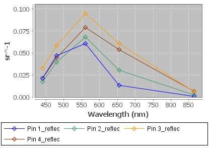
6 Water reflectance spectra of main optical components in water Brockman, DIVERSITY II

7 Rhow Examples from some Norwegian Lakes Souther Norway MERIS 300m resolution Yearly Median Rhow spectra FEM1 FREVAR2 ISE1 LYS RØD1 VAN1 VAN Lambda

8 Example form a trend of phytoplanton in a Norwegian Lake Need to have a robustnes in the algorithm. Around +/- 1-2 microgram/l Chl-a


9 Advantage of S2: spatial resolution L8, Lake Vanern & Vattern, Sweden

10 Water Quality in small bays and Fjords Full 30m resolution


11 Example Lake Alakol Saltwater lake in Kasachstan 2650km², 354m altitude Landsat

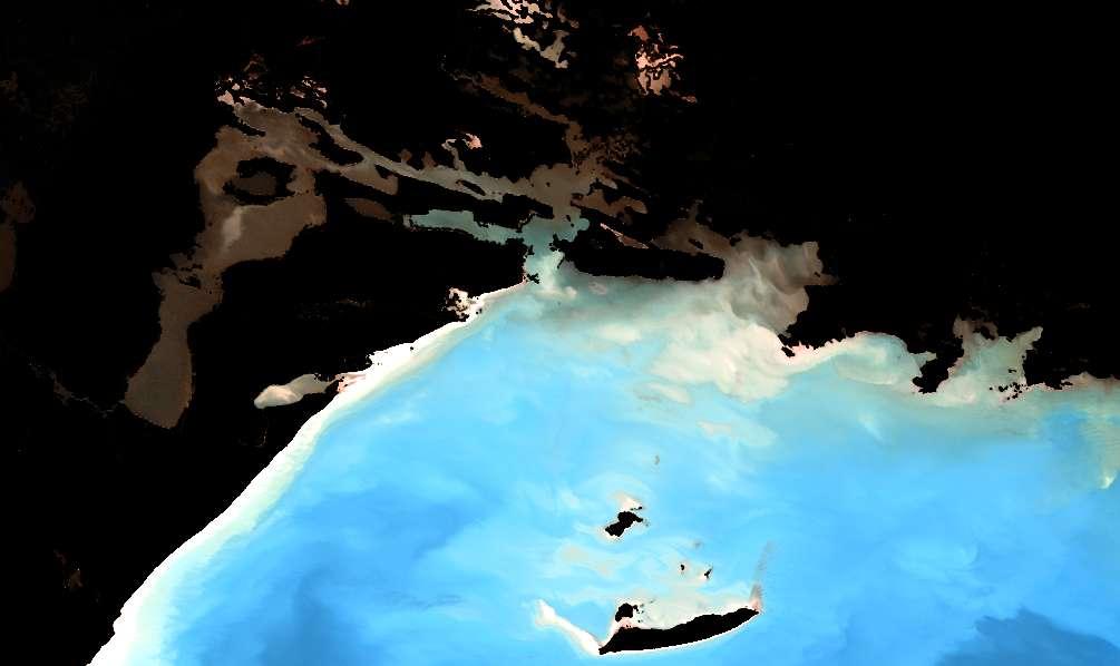

12 Alakol, full resolution
13 What do we need for good water quality retrieval (instrument point of view)? The right radiometry VIS-NIR bands resolving absorption and scattering of the water column NIR-SWIR bands for atmospheric correction Good SNR at typical water spectrum Precisely calibrated Frequent observations Water is a moving target : advection & plankton dynamics Cloud coverage Ideally multiple images per day Spatial resolution 100m or better for coastal area 30m or better for inland waters Good geolocation 1 resultion < 100m
14 Spectral Comparison MERIS OLCI S2 L from ESA Data User Element Project Diversity 2
15 Spectral Comparison MERIS OLCI S2 L from ESA Data User Element Project Diversity 2

16 What do we need for a good water quality retrieval (algorithm requirements)? Example: ESA DUE DIVERSITY II Processing Chain pixel classification in-water processing geometric processing atmospheric correction
17 What do we need for a good water quality retrieval (algorithm requirements)? Geometric processing accuracy 1 pixel is good enough subsetting of large data volumes Pixel Classification Clouds, cloud shadow, snow-ice, mixed water/non-water, floating vegetation, Atmospheric correction ancillary meteorological data: ozone, surface pressure, water vapour aerosol retrieval atmospheric path radiance retrieval including reflection at the water surface (sky radiance, Fresnel reflection, white caps, sun glint, ) In-water processing concentrations of chlorophyll concentration, suspended sediments, CDOM etc Higher level processing temporal and spatial aggregation, phenological parameters,


18 Cloud Screening Pixel Classification MERIS,

19 Cloud Shadows sharper, more distinct compared to medium resolution sensors - not addressed in DIVERSITY II MERIS - algorithm under development - applicable to MERIS, OLCI, S2, L8 - mandatory for S2 / L8 Cloud Shadow
20 Cloud Shadow MERIS/OLCI Mountain Shadows on Fjords Prerequisite: Cloud screening Step 1: Potential cloud shadow area identification Cloud top height (CTH) and cloud base (CBH) estimation Intersection of line-of-sight with cloud Gap filling and shadow buffering Segmentation of potential cloud shadow areas (CloudShadowID) CTH CBH Step 2: Cloud shadow identification For each segmented cloud shadow area perform k-means cluster analysis Sort clusters into either clear and cloud shadow


21 Cloud Shadow Example - MERIS MERIS-FSG 24. September :31:44 RGB Cloud detection IdePix Potential cloud shadow Cloud shadow & potential cloud shadow Cloud shadow
22 Atmospheric Correction (AC) Ocean type AC Condition: Surface signal contributes only few % to TOA signal Low contrast of surface signal Requirement: 3-5% accuracy of surface reflectance Approaches: analytical or numerical inversion of radiative transfer equation assuming a water spectrum & retrieval of aerosol in the NIR Land type AC Condition: Surface signal dominates TOA signal High contrast of surface signal Large spatial and temporal variability of surface signal as well as atmospheric conditions Requirement: less demanding than ocean Approaches: aerosol from VIS or as external input explicit calculation of atmospheric path radiance For coastal & inland waters with S2 we will need both approaches!


23 Ocean Type AC Example Landsat 8


24 Landsat 8 MODIS comparison


25 TSM comparison Structures captured, more definition with Landsat Landsat processed with NN MODIS L2 processing TSM = * PI * Rrs_678 /(1-PI*Rrs_678/0.1774)
26 Data Access and Availability Service Requirements bi-weekly/monthly cloudfree product in order to catch events and resolve critical periods blooming ice melting phenological cycle Data Access NRT for operational purposes (fish farms) 1 day latency for other
27 Service Requirements Stage 1: preprocessing, storage, access Spatial subsetting probably supported by data hub System corrections geometric and radiometric correction if neccessary Pixel classification cloud screening and other pixel classification annotation Projection / mapping if required projection to common grid (possibly better done at Level 2) Meta data, cataloguing and storage Hosted processing for time series processing and full mission reprocessing Long term stewartship

28 GLaSS Core System
29 Service Requirements Stage 2: Value Adding Fast access to preprocessed data data push / pull search by features QC on input data Combination of all available source data (S1+2+3, L8, ) intercalibration if required vicarious calibration Sensor merging Atmoshperic correction Water type classification in-water processing: chl-a, TSM, YS filtering statistical analysis
30 Requirements / unresolved issues S2 calibration accuracy intercalication - CEOS WGCV? Atmospheric correction for inland waters boreal area is specific reflection from forests (adjacency effect) mountain shadows and reflection In-water properties characterisation of specific inherent optical properties database of aparent optical properties (surface reflectances) Product & serviec development In-situ network coastal waters. excellent NIVA experience from ENVISAT, needs continued dedicated ship cruises with dedicated equippment, internationally intercalibrated needs to be complemented with inland water stations
C M E M S O c e a n C o l o u r S a t e l l i t e P r o d u c t s
 Implemented by C M E M S O c e a n C o l o u r S a t e l l i t e P r o d u c t s This slideshow gives an overview of the CMEMS Ocean Colour Satellite Products Marine LEVEL1 For Beginners- Slides have been
Carsten Brockmann, Ana Ruescas, Simon Pinnock CoastColour Team: BC D, HZG D, PML UK, RBINS B, LISE F, FCUL P COASTCOLOUR SPOT 4 TAKE 5
 Carsten Brockmann, Ana Ruescas, Simon Pinnock CoastColour Team: BC D, HZG D, PML UK, RBINS B, LISE F, FCUL P COASTCOLOUR SPOT 4 TAKE 5 CoastColour CoastColour is providing ocean colour products for coastal
Mapping water constituents in Lake Constance using CHRIS/Proba
 S. Miksa, T. Heege, V. Kisselev and P. Gege Mapping water constituents in Lake Constance using CHRIS/Proba 3rd ESA CHRIS/Proba Workshop Frascati,, 21-23 23 March 2005 Overview - Test site and in-situ data
Atmospheric correction in presence of sun glint: the POLYMER Algorithm
 Atmospheric correction in presence of sun glint: the POLYMER Algorithm Dominique Jolivet François Steinmetz Pierre-Yves Deschamps Jan 17, 2011 Atelier National Couleur de l'eau - GIS COOC c 2011 Atmospheric
Sentinel-3 Sea and Land Surface Temperature Radiometer (SLSTR) Mireya Etxaluze (STFC RAL Space)
 Mireya Etxaluze (STFC RAL Space)") Sentinel-3 Sea and Land Surface Temperature Radiometer (SLSTR) Mireya Etxaluze (STFC RAL Space) RAL Space Radiometry Group Dave Smith Mireya Etxaluze, Ed Polehampton, Caroline Cox, Tim Nightingale, Dan
Sentinel-3 Sea and Land Surface Temperature Radiometer (SLSTR) Mireya Etxaluze (STFC RAL Space) RAL Space Radiometry Group Dave Smith Mireya Etxaluze, Ed Polehampton, Caroline Cox, Tim Nightingale, Dan
MERIS, A-MODIS, SeaWiFS, AATSR and PARASOL over the Salar de Uyuni March 2006 MAVT 2006 Marc Bouvet, ESA/ESTEC
 MERIS, A-MODIS, SeaWiFS, AATSR and PARASOL over the Salar de Uyuni Plan of the presentation 1. Introduction : from absolute vicarious calibration to radiometric intercomparison 2. Intercomparison at TOA
OCEAN COLOUR MONITOR ON-BOARD OCEANSAT-2
 OCEAN COLOUR MONITOR ON-BOARD OCEANSAT-2 Rangnath R Navalgund Space Applications Centre Indian Space Research Organisation Ahmedabad-380015, INDIA OCEANSAT-2 2 MISSION OCEANSAT-2 2 is a global mission
MERIS Reprocessing Neural Net Algorithm. Roland Doerffer, Carsten Brockmann,
 MERIS Reprocessing Neural Net Algorithm Roland Doerffer, doerffer@gkss.de Carsten Brockmann, brockmann@brockmann-consult.de MERIS: Aufnahme der Helgoländer Bucht MERIS FR 16.4.2003 Helgoland Bight Section
Vicarious Calibration for MERIS 4 th Reprocessing
 Vicarious Calibration for MERIS 4 th Reprocessing Nicolas Lamquin on behalf of MERIS Quality Working Group FRM4SOC Options for future European satellite OCR vicarious adjustment infrastructure for the
Minutes of the First Meeting. of the IOCCG Working Group. L1 Requirements for Ocean-Colour Remote Sensing. April 20-21, 2010
 Minutes of the First Meeting of the IOCCG Working Group L1 Requirements for Ocean-Colour Remote Sensing April 20-21, 2010 Bethesda, Maryland (Washington, D.C.), USA Participants: - Charles R. McClain (chair,
NASA's Plankton, Aerosol, Cloud, ocean Ecosystem (PACE) mission update
 mission update") NASA's Plankton, Aerosol, Cloud, ocean Ecosystem (PACE) mission update Antonio Mannino1, Jeremy Werdell1, Brian Cairns2 NASA GSFC1 and GISS2 Acknowledgments: PACE Team https://pace.gsfc.nasa.gov 1 Outline
NASA's Plankton, Aerosol, Cloud, ocean Ecosystem (PACE) mission update Antonio Mannino1, Jeremy Werdell1, Brian Cairns2 NASA GSFC1 and GISS2 Acknowledgments: PACE Team https://pace.gsfc.nasa.gov 1 Outline
Long-Term Time Series of Water Vapour Total Columns from GOME, SCIAMACHY and GOME-2
 Graphics: ESA Graphics: ESA Graphics: ESA Long-Term Time Series of Water Vapour Total Columns from GOME, SCIAMACHY and GOME-2 S. Noël, S. Mieruch, H. Bovensmann, J. P. Burrows Institute of Environmental
Cloud screening and snow detection with MERIS. Rene Preusker, Jürgen Fischer, Carsten Brockmann, Marco Zühlke, Uwe krämer, Anja Hünerbein
 Cloud screening and snow detection with MERIS Rene Preusker, Jürgen Fischer, Carsten Brockmann, Marco Zühlke, Uwe krämer, Anja Hünerbein Prelude The following algorithm has been compiled in the frame of
European Space Agency
 Guidelines - Guidelines how/when to interact during the WebEx session: - Due to the number of attendees, please keep always your webcam and microphone switched-off - You can use anytime the chat to all
Using MERIS and MODIS for Land Cover Mapping in the Netherlands
 Using MERIS and for Land Cover Mapping in the Netherlands Raul Zurita Milla, Michael Schaepman and Jan Clevers Wageningen University, Centre for Geo-Information, NL Introduction Actual and reliable information
EUMETSAT STATUS AND PLANS
 1 EUM/TSS/VWG/15/826793 07/10/2015 EUMETSAT STATUS AND PLANS François Montagner, Marine Applications Manager, EUMETSAT WMO Polar Space Task Group 5 5-7 October 2015, DLR, Oberpfaffenhofen PSTG Strategic
MERIS for Case 2 Waters
 MERIS for Case 2 Waters Roland Doerffer &Helmut Schiller GKSS Forschungszentrum Institute for Coastal Research doerffer@gkss.de Case 2 water reflectance spectra North Sea Dissolved and suspended matter
A Method for MERIS Aerosol Correction : Principles and validation. David Béal, Frédéric Baret, Cédric Bacour, Kathy Pavageau
 A Method for MERIS Aerosol Correction : Principles and validation David Béal, Frédéric Baret, Cédric Bacour, Kathy Pavageau Outlook Objectives Principles Training neural networks Validation Comparison
PROBA-V CLOUD MASK VALIDATION
 Version: 1 Page 1 PROBA-V CLOUD MASK VALIDATION Validation Report Version 1.0 Kerstin Stelzer, Michael Paperin, Grit Kirches, Carsten Brockmann 25.04.2016 Version: 1 Page 2 Table of content Abbreviations
S3-A OLCI Cyclic Performance Report. Cycle No Start date: 03/09/2017. End date: 30/09/2017
 PREPARATION AND OPERATIONS OF THE MISSION PERFORMANCE CENTRE (MPC) FOR THE COPERNICUS SENTINEL-3 MISSION Start date: 03/09/2017 End date: 30/09/2017 Contract: 4000111836/14/I-LG Customer: ESA Document
Application of EO for Environmental Monitoring at the Finnish Environment Institute
 Application of EO for Environmental Monitoring at the Finnish Environment Institute Data Processing (CalFin) and Examples of Products Markus Törmä Finnish Environment Institute SYKE markus.torma@ymparisto.fi
In-flight Calibration Techniques Using Natural Targets. CNES Activities on Calibration of Space Sensors
 In-flight Calibration Techniques Using Natural Targets CNES Activities on Calibration of Space Sensors Bertrand Fougnie, Patrice Henry (DCT/SI, CNES, Toulouse, France) In-flight Calibration using Natural
In-flight Spectral Calibration of MERIS/OLCI. Jürgen Fischer, Rene Preusker, Rasmus Lindstrot Institute for Space Science Free University Berlin
 In-flight Spectral Calibration of MERIS/OLCI Jürgen Fischer, Rene Preusker, Rasmus Lindstrot Institute for Space Science Free University Berlin 1 MERIS Instrument 2 MERIS Instrument Concept 3 MERIS Operation
Land Cover Project ESA Climate Change Initiative. Processing chain for land cover maps dedicated to climate modellers.
 Land Cover Project ESA Climate Change Initiative Processing chain for land cover maps dedicated to climate modellers land_cover_cci S. Bontemps 1, P. Defourny 1, V. Kalogirou 2, F.M. Seifert 2 and O. Arino
Report Benefits and Challenges of Geostationary Ocean Colour Remote Sensing - Science and Applications. Antonio Mannino & Maria Tzortziou
 Report Benefits and Challenges of Geostationary Ocean Colour Remote Sensing - Science and Applications Antonio Mannino & Maria Tzortziou Time & Space Scales of OC Relevant Missions GOCI I & II Geo from
Impacts of Atmospheric Corrections on Algal Bloom Detection Techniques
 1 Impacts of Atmospheric Corrections on Algal Bloom Detection Techniques Ruhul Amin, Alex Gilerson, Jing Zhou, Barry Gross, Fred Moshary and Sam Ahmed Optical Remote Sensing Laboratory, the City College
Chlorophyll-a, Phycocyanin and Phytoplankton type products
 Chlorophyll-a, Phycocyanin and Phytoplankton type products Mariano Bresciani, Monica Pinardi, Claudia Giardino CNR IREA bresciani.m@irea.cnr.it Aims Implementation of algorithms dedicated to phytoplankton's
Undergraduate Research Final Report: Estimation of suspended sediments using MODIS 250 m bands in Mayagüez Bay, Puerto Rico
 Undergraduate Research Final Report: Estimation of suspended sediments using MODIS 250 m bands in Mayagüez Bay, Puerto Rico Abstract: José F. Martínez Colón Undergraduate Research 2007 802-03-4097 Advisor:
ESA/MERIS vicarious adjustment
 ESA/MERIS vicarious adjustment Constant Mazeran (ACRI-ST Consultant) Christophe Lerebourg (ACRI-ST), Jean-Paul-Huot (ESA) David Antoine (CNRS-LOV, France & Curtin University, Perth, Australia) Ocean Colour
S3-A OLCI Cyclic Performance Report. Cycle No Start date: 14/06/2017. End date: 11/07/2017
 PREPARATION AND OPERATIONS OF THE MISSION PERFORMANCE CENTRE (MPC) FOR THE COPERNICUS SENTINEL-3 MISSION Start date: 14/06/2017 End date: 11/07/2017 Contract: 4000111836/14/I-LG Customer: ESA Document
Towards eenvironment Prague, March GMES Space Component. Josef Aschbacher Head, ESA GMES Space Office
 Towards eenvironment Prague, 25-27 March 2009 GMES Space Component Josef Aschbacher Head, ESA GMES Space Office Prague from Space Segment 2 05 Nov 2003 CNES 2003 GISAT 2007 ESA GSELAND GMES is an EU led
AEROSOL RETRIEVAL AND ATMOSPHERIC CORRECTION FOR MERIS DATA OVER LAKES
 AEROSOL RETRIEVAL AND ATMOSPHERIC CORRECTION FOR MERIS DATA OVER LAKES Dana Floricioiu, Helmut Rott Institute of Meteorology and Geophysics, University of Innsbruck, Innrain, A-6 Innsbruck, Austria. Email:
HICO OSU Website and Data Products
 HICO OSU Website and Data Products Curtiss O. Davis College of Earth Ocean and Atmospheric Sciences Oregon State University, Corvallis, OR, USA 97331 cdavis@coas.oregonstate.edu Oregon State Introduction
CNES WGCV-36 Report Cal/Val Activities
 CEOS WGCV Meeting 13-17th May 2013, Shangai, China CNES WGCV-36 Report Cal/Val Activities Bertrand Fougnie, Sophie Lachérade, Denis Jouglet, Eric Péquignot, Aimé Meygret, Patrice Henry CNES 1 Summary Pleiades
Sentinel-2 and Sentinel-3 absolute calibration monitoring. C. Desjardins & V. Lonjou CNES
 Sentinel-2 and Sentinel-3 absolute calibration monitoring C. Desjardins & V. Lonjou CNES Radiometric S2A Calibration RRQI, 28 January Workshop, 2016, 30-31/08/2017 CNES SUMMARY CALCON Aug 22-25 2017 VICARIOUS
5.5. Coastal and inland waters
 5.5. Coastal and inland waters 5. Atmospheric Correction SeaWiFS and MODIS Experiences Show: High quality ocean color products for the global open oceans (Case-1 waters). Significant efforts are needed
HICO Calibration and Atmospheric Correction
 HICO Calibration and Atmospheric Correction Curtiss O. Davis College of Earth Ocean and Atmospheric Sciences Oregon State University, Corvallis, OR, USA 97331 cdavis@coas.oregonstate.edu Oregon State Introduction
Astrid Bracher PHYTOOPTICS group, Climate Sciences, AWI & IUP, University Bremen
 Breakout session "Hyperspectral science and applications for shelf and open ocean processes" Hyperspectral ocean color imagery and applications to studies of phytoplankton ecology Astrid Bracher PHYTOOPTICS
Estimation of ocean contribution at the MODIS near-infrared wavelengths along the east coast of the U.S.: Two case studies
 GEOPHYSICAL RESEARCH LETTERS, VOL. 32, L13606, doi:10.1029/2005gl022917, 2005 Estimation of ocean contribution at the MODIS near-infrared wavelengths along the east coast of the U.S.: Two case studies
Current Application of Vicarious Calibration for Geostationary Ocean Color Imager (GOCI) DATA
 DATA") Current Application of Vicarious Calibration for Geostationary Ocean Color Imager (GOCI) DATA On behalf of Jae-Hyun Ahn & Young-je Park, Seongick CHO(Secondment at Astrium SAS, France) Korea Ocean Satellite
Current Application of Vicarious Calibration for Geostationary Ocean Color Imager (GOCI) DATA On behalf of Jae-Hyun Ahn & Young-je Park, Seongick CHO(Secondment at Astrium SAS, France) Korea Ocean Satellite
Algorithm for MERIS land surface BRDF/albedo retrieval and its validation using contemporaneous EO data products
 Algorithm for MERIS land surface BRDF/albedo retrieval and its validation using contemporaneous EO data products Jan-Peter Muller* (UCL) Carsten Brockmann, Marco Zühlke, Norman Fomferra (BC) Jürgen Fischer,
C o p e r n i c u s f o r H i g h r e s o l u t i o n m a p p i n g o f w a t e r q u a l i t y. Copernicus EU
 C o p e r n i c u s f o r H i g h r e s o l u t i o n m a p p i n g o f w a t e r q u a l i t y Copernicus EU Copernicus EU Copernicus EU www.copernicus.eu M o n i t o r i n g o f s e a w a t e r s i n
Calibration of Ocean Colour Sensors
 Dr. A. Neumann German Aerospace Centre DLR Remote Sensing Technology Institute Marine Remote Sensing What is Calibration, why do we need it? Sensor Components Definition of Terms Calibration Standards
Status of ESA EO Programmes
 Status of ESA EO Programmes 54 th ESSC Plenary Meeting 24 November 2017 Maurice Borgeaud, ESA Head of the ESA Earth Observation Science, Applications and Climate Department Issue/Revision: 0.0 Reference:
SEN2COR. Mission Performance Centre ACIX CEOS-WGCV ATMOSPHERIC CORRECTION INTER-COMPARISON EXERCISE ADELPHI MARYLAND USA 21 JUNE 2016
 Mission Performance Centre SEN2COR ACIX CEOS-WGCV ATMOSPHERIC CORRECTION INTER-COMPARISON EXERCISE ADELPHI MARYLAND USA 21 JUNE 2016 SENTINEL-2 MISSION PERFORMANCE CENTRE / 1 SEN2COR OVERVIEW Single-Mission
C o p e r n i c u s L a n d M o n i t o r i n g S e r v i c e
 C o p e r n i c u s L a n d M o n i t o r i n g S e r v i c e Integration into existing Snow and Ice Services and draft product specifications Annett BARTSCH b.geos Copernicus High Resolution Snow and
Product Notice ID. OL_2_LFR in NRT and NTC OL_2_LRR in NRT and NTC. Product. Issue/Rev Date 25/01/2019 Version 1.0
 S3 Product Notice OLCI Mission Sensor Product & OLCI OL_2_LFR in NRT and NTC OL_2_LRR in NRT and NTC Product Notice ID S3.PN-OLCI-L2L.02 Issue/Rev Date 25/01/2019 Version 1.0 Preparation This Product Notice
Introduction into Ocean Coulour Remote Sensing using MERIS data
 ESA Training Course Oceanography from Space Hamburg, September 25-29 2006 Introduction into Ocean Coulour Remote Sensing using MERIS data Roland Doerffer GKSS Research Center Institute for Coastal Research
Copernicus Marine Environment Monitoring Service
 Copernicus Marine Environment Monitoring Service Mercator Ocean March 2017 Implemented by Entrusted to Mercator Ocean by the European Commission Cliquez et modifiez le titre French non-profit company Owned
Atmospheric Measurements from Space
 Atmospheric Measurements from Space MPI Mainz Germany Thomas Wagner Satellite Group MPI Mainz Part 1: Basics Break Part 2: Applications Part 1: Basics of satellite remote sensing Why atmospheric satellite
Cloud masking as cross-cutting issue
 Cloud masking as cross-cutting issue Presentation to CEOS/WGCV activity project planning meeting Rainer Hollmann, Cornelia Schlundt, Satellite based Climate Monitoring Deutscher Wetterdienst Outline Need
Ocean Colour Remote Sensing in Turbid Waters. Lecture 2: Introduction to computer exercise #1 The Colour of Water.
 Ocean Colour Remote Sensing in Turbid Waters Lecture 2: Introduction to computer exercise #1 The Colour of Water by Kevin Ruddick Overview of this lecture Objective: introduce the HYPERTEACH ocean colour
AUTOMATISIERTE ZEITREIHENANALYSE VON FERNERKUNDUNGSDATEN FÜR DAS MONITORING VON OBERFLÄCHENGEWÄSSERN
 Place image here (10 x 3.5 ) AUTOMATISIERTE ZEITREIHENANALYSE VON FERNERKUNDUNGSDATEN FÜR DAS MONITORING VON OBERFLÄCHENGEWÄSSERN THOMAS BAHR & NICOLAI HOLZER 23. Workshop Arbeitskreis Umweltinformationssysteme
Greening of Arctic: Knowledge and Uncertainties
 Greening of Arctic: Knowledge and Uncertainties Jiong Jia, Hesong Wang Chinese Academy of Science jiong@tea.ac.cn Howie Epstein Skip Walker Moscow, January 28, 2008 Global Warming and Its Impact IMPACTS
Geoscience Australia Report on Cal/Val Activities
 Medhavy Thankappan Geoscience Australia Agency Report I Berlin May 6-8, 2015 Outline 1. Calibration / validation at Geoscience Australia Corner reflector infrastructure for SAR calibration (for information)
Snow Cover Applications: Major Gaps in Current EO Measurement Capabilities
 Snow Cover Applications: Major Gaps in Current EO Measurement Capabilities Thomas NAGLER ENVEO Environmental Earth Observation IT GmbH INNSBRUCK, AUSTRIA Polar and Snow Cover Applications User Requirements
A 2016 CEOS Chair Initiative. Non-meteorological Applications for Next Generation Geostationary Satellites
 A 2016 CEOS Chair Initiative Committee on Earth Observation Satellites Non-meteorological Applications for Next Generation Geostationary Satellites Co-chaired by EUMETSAT (Holmlund), CSIRO (Schroeder),
CNES Activity Report. Patrice Henry - CNES WGCV Plenary # 41 Tokyo Sept. 5-7, Working Group on Calibration and Validation
 Activity Report Patrice Henry - Tokyo Sept. 5-7, 2016 Working Group on Calibration and Validation SUMMARY Calibration Monitoring of in-flight Missions Preparation of future Missions Involvement in CEOS/WGCV
Non-meteorological Applications for Next Generation Geostationary Satellites: A 2016 CEOS Chair Initiative
 Committee on Earth Observation Satellites Non-meteorological Applications for Next Generation Geostationary Satellites: A 2016 CEOS Chair Initiative Ian Grant, Australian Bureau of Meteorology (Adapted
NASA s Airborne Visible/Infrared Imaging Spectrometer (AVIRIS) AVIRIS: PEARL HARBOR, HAWAII
 AVIRIS: PEARL HARBOR, HAWAII") AVIRIS: PEARL HARBOR, HAWAII 000412 NASA s Airborne Visible/Infrared Imaging Spectrometer (AVIRIS) LCLUC Update Robert O. Green (Tom Chrien, presenting) Jet Propulsion Laboratory Overview Objective & Approach
AVIRIS: PEARL HARBOR, HAWAII 000412 NASA s Airborne Visible/Infrared Imaging Spectrometer (AVIRIS) LCLUC Update Robert O. Green (Tom Chrien, presenting) Jet Propulsion Laboratory Overview Objective & Approach
ASSESSMENT OF THE UNCERTAINTY OF ATMOSPHERIC SCATTERING FUNCTIONS USED IN MERIS ATMOSPHERIC CORRECTION OVER WATER.
 ASSESSMENT OF THE UNCERTAINTY OF ATMOSPHERIC SCATTERING FUNCTIONS USED IN MERIS ATMOSPHERIC CORRECTION OVER WATER Francis Zagolski Motivations Ø Contribute to the MERIS validation of L2 optical parameters
Coastal Water Quality Monitoring in Cyprus using Satellite Remote Sensing
 Coastal Water Quality Monitoring in Cyprus using Satellite Remote Sensing D. G. Hadjimitsis 1*, M.G. Hadjimitsis 1, 2, A. Agapiou 1, G. Papadavid 1 and K. Themistocleous 1 1 Department of Civil Engineering
The VENμS mission: Earth Observation with High Spatial and Temporal Resolution Capabilities
 Ben Gurion University The VENμS mission: Earth Observation with High Spatial and Temporal Resolution Capabilities G. Dedieu 1, O. Hagolle 2, A. Karnieli 3, S. Cherchali 2 P. Ferrier 2 and Y. Yaniv 4 1
Hyperspectral Atmospheric Correction
 Hyperspectral Atmospheric Correction Bo-Cai Gao June 2015 Remote Sensing Division Naval Research Laboratory, Washington, DC USA BACKGROUND The concept of imaging spectroscopy, or hyperspectral imaging,
A NEW CLIMATOLOGY OF SEA SURFACE WIND SPEED UNDER CLOUD FREE CONDITIONS FOR THE ESTIMATION OF THE IMPACT OF SUNGLINT IN GMES PHASE A SENTINEL 3
 A NEW CLIMATOLOGY OF SEA SURFACE WIND SPEED UNDER CLOUD FREE CONDITIONS FOR THE ESTIMATION OF THE IMPACT OF SUNGLINT IN GMES PHASE A SENTINEL 3 Mounir Lekouara 1, Bernardo Carnicero Dominguez 2 and Miguel
Automated ocean color product validation for the Southern California Bight
 Automated ocean color product validation for the Southern California Bight Curtiss O. Davis a, Nicholas Tufillaro a, Burt Jones b, and Robert Arnone c a College of Earth, Ocean and Atmospheric Sciences,
Detection of ship NO 2 emissions over Europe from satellite observations
 Detection of ship NO 2 emissions over Europe from satellite observations Huan Yu DOAS seminar 24 April 2015 Ship Emissions to Atmosphere Reporting Service (SEARS project) Outline Introduction Shipping
Ocean Colour: Calibration Approach. CEOS WGCV-39, May The International Ocean Colour Coordinating Group
 Ocean Colour: Calibration Approach CEOS WGCV-39, May 2015 The International Ocean Colour Coordinating Group Ocean Colour requires special calibration considerations Percentage of ocean signal in the total
Advanced Geostationary Observations for the OzEWEX Community. Leon Majewski Bureau of Meteorology
 Advanced Geostationary Observations for the OzEWEX Community Leon Majewski Bureau of Meteorology Overview Geostationary satellite missions & sensors Meteorological applications Access for OzEWEX researchers
In-flight Evaluation of the SPOT-6 Radiometric Calibration based on Acquisitions over Natural Targets and Automated in-situ Measurements
 In-flight Evaluation of the SPOT-6 Radiometric Calibration based on Acquisitions over Natural Targets and Automated in-situ Measurements Philippe GAMET, Bertrand FOUGNIE, Sophie LACHERADE (CNES), Mathieu
Overview of AVIRIS Acquisitions in Argentina as Part of the NM EO-1 Campaign in 2001
 Overview of AVIRIS Acquisitions in Argentina as Part of the NM EO-1 Campaign in 2001 Robert O. Green, Mike Eastwood, Ian McCubbin, Chris Chovit, Jim Raney, Jack Holbrook, plus others... Jet Propulsion
Aerosols from Sentinel 3 and EarthCARE missions
 Aerosols from Sentinel 3 and EarthCARE missions Michael Eisinger, Tobias Wehr, Dulce Lajas, Alain Lefebvre European Space Agency Aerosol Observability Workshop 27-29 April 2010 Monterey, CA Page 1 Outline
S3-A OLCI Cyclic Performance Report. Cycle No Start date: 27/10/2017. End date: 23/11/2017
 PREPARATION AND OPERATIONS OF THE MISSION PERFORMANCE CENTRE (MPC) FOR THE COPERNICUS SENTINEL-3 MISSION Start date: 27/10/2017 End date: 23/11/2017 Contract: 4000111836/14/I-LG Customer: ESA Document
National Satellite Data Centre and Finnish Sentinel Collaborative Ground Segment. Jyri Heilimo Finnish Meteorological Instute
 National Satellite Data Centre and Finnish Sentinel Collaborative Ground Segment Jyri Heilimo Finnish Meteorological Instute Sodankylä National Satellite Data Centre National satellite data centre providing
Improvement of the retrieval of aerosol optical properties over oceans using SEVIRI
 Improvement of the retrieval of aerosol optical properties over oceans using SEVIRI A. Vermeulen 1, C. Moulin 2, F. Thieuleux 3, I. Chiapello 3, J. Descloitres 1, F. Ducos 3, J-M Nicolas 1, F.-M. Bréon
CadasterENV Sweden Time series in support of a multi-purpose land cover mapping system at national scale
 CadasterENV Sweden Time series in support of a multi-purpose land cover mapping system at national scale Mats Rosengren, Camilla Jönsson ; Metria AB Marc Paganini ; ESA ESRIN Background CadasterENV Sweden
EUMETSAT s Copernicus Marine Data Stream (CMDS)
") EUMETSAT s Copernicus Marine Data Stream (CMDS) Hayley Evers-King (PML, Copernicus Ocean Training Service), Mark Higgins Copernicus Sentinel 3 marine data Sentinel 3 SRAL (Altimetry) SLSTR (SST) OLCI (Ocean
EUMETSAT s Copernicus Marine Data Stream (CMDS) Hayley Evers-King (PML, Copernicus Ocean Training Service), Mark Higgins Copernicus Sentinel 3 marine data Sentinel 3 SRAL (Altimetry) SLSTR (SST) OLCI (Ocean
Polar Multi-Sensor Aerosol Product: User Requirements
 Polar Multi-Sensor Aerosol Product: User Requirements Doc.No. Issue : : EUM/TSS/REQ/13/688040 v2 EUMETSAT EUMETSAT Allee 1, D-64295 Darmstadt, Germany Tel: +49 6151 807-7 Fax: +49 6151 807 555 Telex: 419
Arctic-Coastal Land Ocean Interactions
 Arctic- Project PIs: Maria Tzortziou (CCNY / CUNY) Antonio Mannino (NASA/GSFC) Joseph Salisbury (Univ. of NH) Peter Hernes (UC Davis) Carlos Del Castillo (NASA/GSFC) Marjorie Friedrichs (VIMS) Patricia
Satellite-based Red-Tide Detection/Monitoring
 Satellite-based Detection/Monitoring Contents 1. Introduction - and Its Monitoring System 2. Detection Using Ocean Color Remote Sensing 3. Satellite-Based Monitoring in the Asian Coastal Seas Hiroshi KAWAMURA
The Coastal Ocean Applications and Science Team (COAST): Science Support for a Geostationary Ocean Color Imager for Coastal Waters
: Science Support for a Geostationary Ocean Color Imager for Coastal Waters") The Coastal Ocean Applications and Science Team (COAST): Science Support for a Geostationary Ocean Color Imager for Coastal Waters PIs: Curt Davis and Mark Abbott NOAA Technical Contact: Paul Menzel, NOAA/STAR.
The Coastal Ocean Applications and Science Team (COAST): Science Support for a Geostationary Ocean Color Imager for Coastal Waters PIs: Curt Davis and Mark Abbott NOAA Technical Contact: Paul Menzel, NOAA/STAR.
EVOLUTION OF THE C2RCC NEURAL NETWORK FOR SENTINEL 2 AND 3 FOR THE RETRIEVAL OF OCEAN COLOUR PRODUCTS IN NORMAL AND EXTREME OPTICALLY COMPLEX WATERS
 EVOLUTION OF THE C2RCC NEURAL NETWORK FOR SENTINEL 2 AND 3 FOR THE RETRIEVAL OF OCEAN COLOUR PRODUCTS IN NORMAL AND EXTREME OPTICALLY COMPLEX WATERS Brockmann, Carsten (1), Doerffer, Roland (1), Peters,
Sentinel-3: Lessons from AATSR/MERIS Synergy. Peter North Swansea University
 Sentinel-3: Lessons from AATSR/MERIS Synergy Peter North Swansea University Introduction ESA projects relevant to Sentinel-3: Aerosol CCI MERIS/AATSR Synergy GlobAlbedo SEN4LST S3 Algorithm development
Comparison between MERIS and GOCI in regional seas around Korea
 Comparison between MERIS and GOCI in regional seas around Korea Young-Je Park, Yu-Hwan Ahn, Jung-Mi Yoo KOSC staff Korea Ocean Satellite Center (KOSC), Korea Ocean Research and Development Institute (KODI)
Ocean Color Algorithms for the Southern Ocean Constraining the Carbon cycle
 Ocean Color Algorithms for the Southern Ocean Constraining the Carbon cycle Report Breakout Session No. 5 IOCS 2017 Lisbon, Portugal Maria Vernet Scripps Institution of Oceanography, USA Antarctic Fronts:
Impact of Climate Change on Polar Ecology Focus on Arctic
 Impact of Climate Change on Polar Ecology Focus on Arctic Marcel Babin Canada Excellence Research Chair on Remote sensing of Canada s new Arctic Frontier Takuvik Joint International Laboratory CNRS & Université
CopernicusEU. the EU's Earth Observation Programme. Sara Zennaro Atre Delegation of the European Union to Japan
 Copernicus the EU's Earth Observation Programme Sara Zennaro Atre Delegation of the European Union to Japan Status Overview, Sept 2016 & Ocean Policies Seminar 4 October 2016 ollow us on: Copernicus EU
A case for FLH in coastal waters: monitoring the spring bloom in British Columbia, Canada, plus MCI examples
 A case for FLH in coastal waters: monitoring the spring bloom in British Columbia, Canada, plus MCI examples Jim Gower, Stephanie King, Institute of Ocean Sciences, Fisheries and Oceans Canada, Sidney
Extending the Deep Blue aerosol record from SeaWiFS and MODIS to NPP-VIIRS
 Extending the Deep Blue aerosol record from SeaWiFS and MODIS to NPP-VIIRS Andrew M. Sayer, N. Christina Hsu (PI), Corey Bettenhausen, Jaehwa Lee Climate & Radiation Laboratory, NASA Goddard Space Flight
Infrastructure monitoring using SAR interferometry
 Infrastructure monitoring using SAR interferometry Hossein Nahavandchi Roghayeh Shamshiri Norwegian University of Science and Technology (NTNU), Department of Civil and Environmental Engineering Geodesy
S3-A OLCI Cyclic Performance Report. Cycle No Start date: 20/12/2017. End date: 16/01/2018
 PREPARATION AND OPERATIONS OF THE MISSION PERFORMANCE CENTRE (MPC) FOR THE COPERNICUS SENTINEL-3 MISSION Start date: 20/12/2017 End date: 16/01/2018 Contract: 4000111836/14/I-LG Customer: ESA Document
Pan-Arctic, Regional and Local Land Cover Products
 Pan-Arctic, Regional and Local Land Cover Products Marcel Urban (1), Stefan Pöcking (1), Sören Hese (1) & Christiane Schmullius (1) (1) Friedrich-Schiller University Jena, Department of Earth Observation,
EUMETSAT Activities Related to Climate
 EUMETSAT Activities Related to Climate Jörg Schulz joerg.schulz@eumetsat.int Slide: 1 What we do USER REQUIREMENTS European National Meteorological Services Operating Agency! European Space Industry Private
Cloud detection using SEVIRI IR channels
 Cloud detection using SEVIRI IR channels Alessandro.Ipe@oma.be & Luis Gonzalez Sotelino Royal Meteorological Institute of Belgium GERB Science Team Meeting @ London September 9 10 2009 1 / 19 Overview
MSG system over view
 MSG system over view 1 Introduction METEOSAT SECOND GENERATION Overview 2 MSG Missions and Services 3 The SEVIRI Instrument 4 The MSG Ground Segment 5 SAF Network 6 Conclusions METEOSAT SECOND GENERATION
sentinel-3 A BIGGER PICTURE FOR COPERNICUS
 sentinel-3 A BIGGER PICTURE FOR COPERNICUS SATELLITES TO SERVE By providing a set of key information services for a wide range of practical applications, Europe s Copernicus programme has been put in place
Simulated Radiances for OMI
 Simulated Radiances for OMI document: KNMI-OMI-2000-004 version: 1.0 date: 11 February 2000 author: J.P. Veefkind approved: G.H.J. van den Oord checked: J. de Haan Index 0. Abstract 1. Introduction 2.
Spectral surface albedo derived from GOME-2/Metop measurements
 Spectral surface albedo derived from GOME-2/Metop measurements Bringfried Pflug* a, Diego Loyola b a DLR, Remote Sensing Technology Institute, Rutherfordstr. 2, 12489 Berlin, Germany; b DLR, Remote Sensing
The Orbiting Carbon Observatory (OCO)
") GEMS 2006 Assembly The Orbiting Carbon Observatory (OCO) http://oco.jpl.nasa.gov David Crisp, OCO PI (JPL/Caltech) February 2006 1 of 13, OCO Dec 2005 Page 1 The Orbiting Carbon Observatory (OCO) OCO will
GEMS 2006 Assembly The Orbiting Carbon Observatory (OCO) http://oco.jpl.nasa.gov David Crisp, OCO PI (JPL/Caltech) February 2006 1 of 13, OCO Dec 2005 Page 1 The Orbiting Carbon Observatory (OCO) OCO will
Time Series Analysis with SAR & Optical Satellite Data
 Time Series Analysis with SAR & Optical Satellite Data Thomas Bahr ESRI European User Conference Thursday October 2015 harris.com Motivation Changes in land surface characteristics mirror a multitude of