CadasterENV Sweden Time series in support of a multi-purpose land cover mapping system at national scale
|
|
|
- Owen West
- 5 years ago
- Views:
Transcription

1 CadasterENV Sweden Time series in support of a multi-purpose land cover mapping system at national scale Mats Rosengren, Camilla Jönsson ; Metria AB Marc Paganini ; ESA ESRIN


2 Background CadasterENV Sweden National mapping (at 10 m and 2 m pixel size) Stage1 funded by ESA Developed by Metria Defined by Swedish national and regional users
![Stepwise development Stage 1: CadasterENV ESA financed project 2012-15 Spot 5 (10 m) [large areas] and Plèiades [urban] ALS airborne lidar (DEM and object heights) Ancillary data (buildings, water](/docs-images/90/104102456/images/3-2.jpg "bodies, LPIS.")
3 Stepwise development Stage 1: CadasterENV ESA financed project Spot 5 (10 m) [large areas] and Plèiades [urban] ALS airborne lidar (DEM and object heights) Ancillary data (buildings, water bodies, LPIS..) Stage 2: Time series based methods for specific purposes (2016) using data from Spot5Take5 and Sentinel-2 Stage 3: Full scale implementation and production Budget for project start mid 2016 Aim for full production Added support from new users
4 Primary Input data SPOT5 10m VHR (alt orthophoto) 0,5-2m LIDAR
 0,5-2m LIDAR Sentinel 2A/2B")
5 Primary Input data SPOT5 10m VHR (alt orthophoto) 0,5-2m LIDAR Sentinel 2A/2B 10m
: Stockholm Linköping Norrköping Umeå")
6 Mapped areas - stage1 HR (10 m resolution): Stockholm county Östergötland county Västerbotten county VHR (2 m resolution MS): Stockholm Linköping Norrköping Umeå

7 Products Joint user defined legend meeting a diversity of requirements Map with 24 thematic classes Level 1-3 HR / VHR Raster 10 / 2 meter MMU HR: 10 m pixel product and ha for different classes VHR: 2 m pixel product Many forest classes Separate layers (attributes) Land use Tree height Tree density Productivity
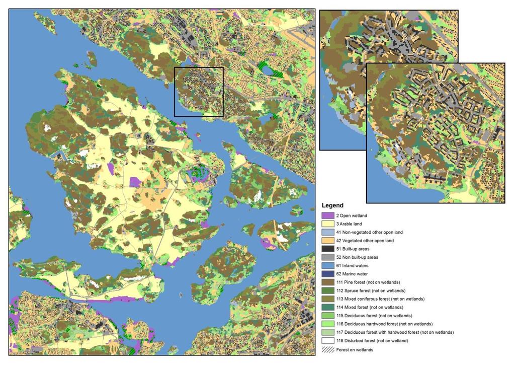
8 HR VHR
9 HR CadasterENV

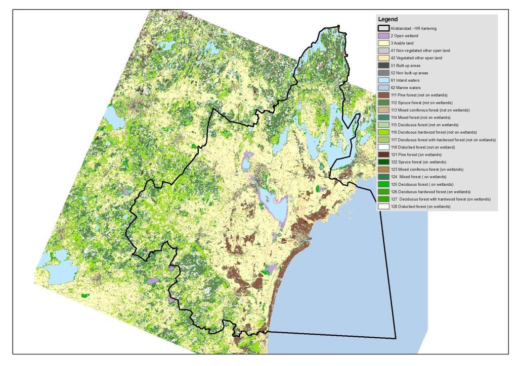
10 Forest - HR CadasterENV


11 Examples of downstream use New land cover map Nature 2000 habitat mapping Fuel type maps Radio wave coverage Ecosystem services Forest continuity Monitoring wetlands Biotope database Urban green areas Green infrastructure
12 What are the problems to be solved by Sentinel-2 data and time series? The major problem is availability of useful data Short vegetation season (< 8 weeks in northern Sweden) Low sun angle (from september) Clouds (1-2 week cloudfree episodes of high pressure) Use of mosaics/composites for classification Phenology for agriculture, wetlands, deciduous forest types ) Multi-year data for delineation of changes


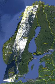
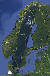
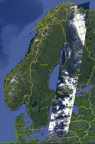
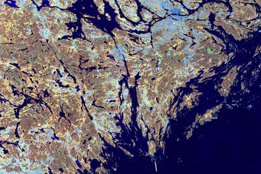
13 Data availability with 5 day revisit Sweden : Västerbotten Sweden : Stockholm Spot5Take5 every 5th day April September 2015 Sweden : Östergötland

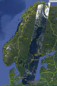
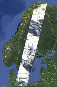
14 Sentinel-2 relative orbits 5 day revisit north of 57 deg N 90% of Sweden 7 of 10 days cover part of Sweden 2 satellites => every 2-3 days 57 deg N


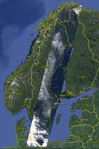
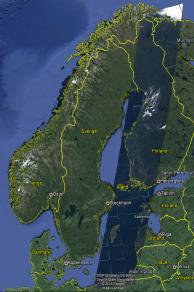
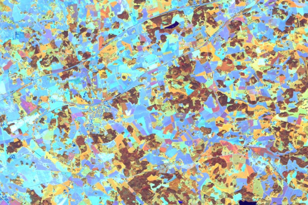
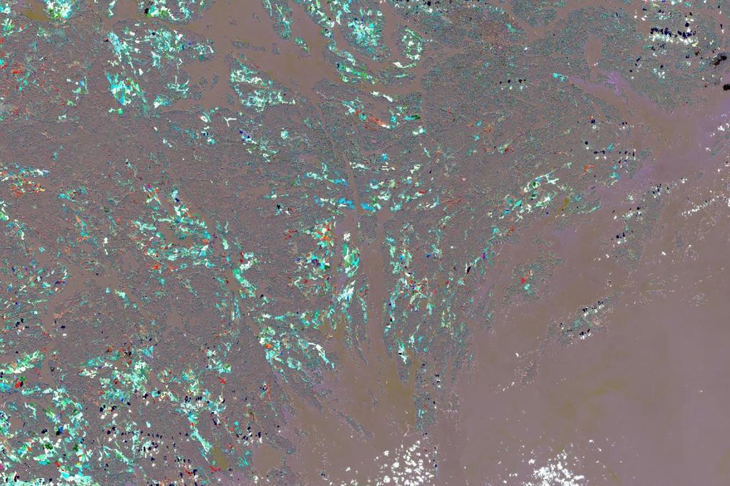
15 Sentinel-2 Sweden August

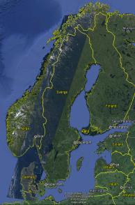
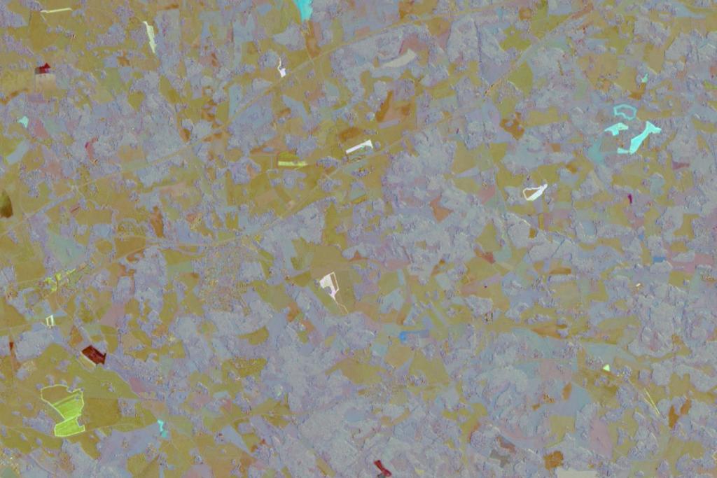
16 Best pixel composite
 Open wetlands Arable land/other open land A more detailed classification Sub classes in open land based on field layer vegetation (e.g. grassland/moore and heathland) Deciduous forest classes (e.")
17 Sentinel-2 for CadasterENV Expected improvements with Sentinel-2 data: Better classification accuracy Mixed deciduous forest and deciduous forest Water and och aquatic vegetation (average water level) Open wetlands Arable land/other open land A more detailed classification Sub classes in open land based on field layer vegetation (e.g. grassland/moore and heathland) Deciduous forest classes (e.g. oak and och ash forest) Mountaenous areas Identifying slow change Long term transition from arable land to other open land and transitions between different forest classes. Overgrowth More cost effective method Larger scenes More scenes (access to more cloud free scenes from optimal time of year) More automatic processes
18
19
20 CadasterENV 2016 ESA funding to Metria during 2016 to further develop methods of mapping and production of CadasterENV using Sentinel 2 (and SPOT5Take5). We will focus on: 1. Methods to divide the open land class into arable land and different types of grasslands and wetlands (phenology from time series) 2. Methods to delineate water and wetlands using average water levels (seasonal variation) 3. Methods to improve the accuracy of deciduous forest classes (phenology). 4. Methods for incorporating Sentinel 2 data in to the production chain of CadasterENV and assessment of cost. Results november 2016.
21 Preparation of satellite data for national mapping with 10m pixels Before 2016 Large manual and costly effort to prepare data Select suitable imagery from the national yearly SPOT archive Manual cloud /cloud shadow masking Post classification mosaiking of many small pieces From 2016 More cloud free pixels from suitable dates Automatic cloud and shadow detection Use of seasonal composites /time series Automatic methods needed to handle all the data
22 A robust cloud and shadow mask is required Sentinel2 L1C cloudmasks are a good starting point These will be expanded and improved Cloud shadow masks is the main issue
23 A concept for an automatic improvement of cloud masks and added cloud shadow masks 1. L1C TOA reflectance 2. Use reasonable cloud free images (< 50%) to make a reference cloud free composite images (p25, p50, p75..) 3. Make bandwise difference images target reference scene 4. Set bandwise TOA thresholds for extracting clouds / shadows. 5. Remove shadow pixels without neighboring cloud 6. Expand masks 7. Iterate

24 Spot5Take5 15 scenes median cloud free reference

25 Original scene

26 Difference vs cloud free reference compos
27 Cloud mask from tresholded di

28 Cloud shadow mask from tresholded di


29 Thank you! Earth Observation Data Processing Data Provision Data Production Data Management Map Production Surveying Land cover Mapping Geodata Services Customized IT-solutions Metria the link between map and reality Urban Planning Environmental Monitoring Management & Consultancy Advanced GIS-analysis 3D-Modeling GIS as a service Ecosystem Services
UK Contribution to the European CORINE Land Cover
 Centre for Landscape andwww.le.ac.uk/clcr Climate Research CENTRE FOR Landscape and Climate Research UK Contribution to the European CORINE Land Cover Dr Beth Cole Corine Coordination of Information on
C O P E R N I C U S F O R G I P R O F E S S I O N A L S
 C O P E R N I C U S F O R G I P R O F E S S I O N A L S Downstream Applications MALTA 2017-06-26 Pascal Lory, EUROGI EU EU EU www.copernicus.eu S c o p e Identifying urban housing density: Stella Ofori-Ampofo,
Overview on Land Cover and Land Use Monitoring in Russia
 Russian Academy of Sciences Space Research Institute Overview on Land Cover and Land Use Monitoring in Russia Sergey Bartalev Joint NASA LCLUC Science Team Meeting and GOFC-GOLD/NERIN, NEESPI Workshop
Urban remote sensing: from local to global and back
 Urban remote sensing: from local to global and back Paolo Gamba University of Pavia, Italy A few words about Pavia Historical University (1361) in a nice town slide 3 Geoscience and Remote Sensing Society
C o p e r n i c u s L a n d M o n i t o r i n g S e r v i c e
 C o p e r n i c u s L a n d M o n i t o r i n g S e r v i c e Submodule D: stability of protected areas & related pressures: Natura2000 sites Copernicus EU Copernicus EU Copernicus EU www.copernicus.eu
Spatial Process VS. Non-spatial Process. Landscape Process
 Spatial Process VS. Non-spatial Process A process is non-spatial if it is NOT a function of spatial pattern = A process is spatial if it is a function of spatial pattern Landscape Process If there is no
The LISA extension to INSPIRE LC/LU data model: The Austrian experience
 The LISA extension to INSPIRE LC/LU data model: The Austrian experience Gebhard Banko, Environment Agency Austria Roland Grillmayer, Environment Agency Austria Wolfgang Stemberger, GeoVille INSPIRE KEN
Spanish national plan for land observation: new collaborative production system in Europe
 ADVANCE UNEDITED VERSION UNITED NATIONS E/CONF.103/5/Add.1 Economic and Social Affairs 9 July 2013 Tenth United Nations Regional Cartographic Conference for the Americas New York, 19-23, August 2013 Item
Data Fusion and Multi-Resolution Data
 Data Fusion and Multi-Resolution Data Nature.com www.museevirtuel-virtualmuseum.ca www.srs.fs.usda.gov Meredith Gartner 3/7/14 Data fusion and multi-resolution data Dark and Bram MAUP and raster data Hilker
KNOWLEDGE-BASED CLASSIFICATION OF LAND COVER FOR THE QUALITY ASSESSEMENT OF GIS DATABASE. Israel -
 KNOWLEDGE-BASED CLASSIFICATION OF LAND COVER FOR THE QUALITY ASSESSEMENT OF GIS DATABASE Ammatzia Peled a,*, Michael Gilichinsky b a University of Haifa, Department of Geography and Environmental Studies,
Building a validation database for land cover products from high spatial resolution images
 Building a validation database for land cover products from high spatial resolution images The Land Cover project of the ESA Climate Change Initiative Bontemps Sophie 1, Achard Frédéric 2, Lamarche Céline
An Internet-based Agricultural Land Use Trends Visualization System (AgLuT)
") An Internet-based Agricultural Land Use Trends Visualization System (AgLuT) Second half yearly report 01-01-2001-06-30-2001 Prepared for Missouri Department of Natural Resources Missouri Department of
An Internet-based Agricultural Land Use Trends Visualization System (AgLuT) Second half yearly report 01-01-2001-06-30-2001 Prepared for Missouri Department of Natural Resources Missouri Department of
EO Information Services. Assessing Vulnerability in the metropolitan area of Rio de Janeiro (Floods & Landslides) Project
 Project") EO Information Services in support of Assessing Vulnerability in the metropolitan area of Rio de Janeiro (Floods & Landslides) Project Ricardo Armas, Critical Software SA Haris Kontoes, ISARS NOA World
EO Information Services in support of Assessing Vulnerability in the metropolitan area of Rio de Janeiro (Floods & Landslides) Project Ricardo Armas, Critical Software SA Haris Kontoes, ISARS NOA World
sentinel-2 COLOUR VISION FOR COPERNICUS
 sentinel-2 COLOUR VISION FOR COPERNICUS SATELLITES TO SERVE By providing a set of key information services for a wide range of practical applications, Europe s Copernicus programme is providing a step
USING HYPERSPECTRAL IMAGERY
 USING HYPERSPECTRAL IMAGERY AND LIDAR DATA TO DETECT PLANT INVASIONS 2016 ESRI CANADA SCHOLARSHIP APPLICATION CURTIS CHANCE M.SC. CANDIDATE FACULTY OF FORESTRY UNIVERSITY OF BRITISH COLUMBIA CURTIS.CHANCE@ALUMNI.UBC.CA
LAND COVER CHANGES IN ROMANIA BASED ON CORINE LAND COVER INVENTORY
 LAND COVER CHANGES IN ROMANIA BASED ON CORINE LAND COVER INVENTORY 1990 2012 JENICĂ HANGANU, ADRIAN CONSTANTINESCU * Key-words: CORINE Land Cover inventory, Land cover changes, GIS. Abstract. From 1990
APPENDIX. Normalized Difference Vegetation Index (NDVI) from MODIS data
 from MODIS data") APPENDIX Land-use/land-cover composition of Apulia region Overall, more than 82% of Apulia contains agro-ecosystems (Figure ). The northern and somewhat the central part of the region include arable lands
APPENDIX Land-use/land-cover composition of Apulia region Overall, more than 82% of Apulia contains agro-ecosystems (Figure ). The northern and somewhat the central part of the region include arable lands
EO4SEE - THE PATHFINDER OF OPERATIONAL SATELLITE MONITORING FOR THE REGION OF THE BLACK SEA AND CENTRAL EUROPE
 EO4SEE: Pathfinder assessment for regional high volume data access, processing and information service delivery platforms - South East Region EO4SEE - THE PATHFINDER OF OPERATIONAL SATELLITE MONITORING
GLOBWETLAND AFRICA TOOLBOX
 The GlobWetland Africa Toolbox is an open source and free-of-charge software toolbox for inventorying, mapping, monitoring and assessing wetlands. The toolbox comes with end-to-end processing workflows
C o p e r n i c u s L a n d M o n i t o r i n g S e r v i c e
 C o p e r n i c u s L a n d M o n i t o r i n g S e r v i c e Integration into existing Snow and Ice Services and draft product specifications Annett BARTSCH b.geos Copernicus High Resolution Snow and
ESA-GLOBCOVER - A Global Land Cover Service at 300 m from ENVISAT MERIS Time Series
 October 15, 2008 (Jena Germany) ESA-GLOBCOVER - A Global Land Cover Service at 300 m from ENVISAT MERIS Time Series Defourny P.1, Bontemps S., Vancutsem C.1, Pekel J.F.1,, Vanbogaert E.1, Bicheron P.2,
The German GMES extension to support land cover data systems: Status and outlook
 The German GMES extension to support land cover data systems: Status and outlook Bergen, 2nd July 2010 Oliver Buck, EFTAS GmbH Co-Funded by the Federal Ministry of Economics and Technology (BMWi) via the
Green areas: numerous positive effects for sustainable metropolis Satellite images : an easy way to map vegetation
 Green areas: numerous positive effects for sustainable metropolis Satellite images : an easy way to map vegetation Copernicus Training and Information Session 10 and 11 may 2017 in Lund, Sweden Dominique
New Land Cover & Land Use Data for the Chesapeake Bay Watershed
 New Land Cover & Land Use Data for the Chesapeake Bay Watershed Why? The Chesapeake Bay Program (CBP) partnership is in the process of improving and refining the Phase 6 suite of models used to inform
Land Monitoring Core Service Implementation Group (LMCS IG) - Results and Outlook
 - Results and Outlook") Land Monitoring Core Service Implementation Group (LMCS IG) - Results and Outlook Pr. Dietmar Grünreich, President of BKG, Germany Chairman of the GMES LMCS IG Outline 1 Introduction 2 Preparatory Projects
Land Monitoring Core Service Implementation Group (LMCS IG) - Results and Outlook Pr. Dietmar Grünreich, President of BKG, Germany Chairman of the GMES LMCS IG Outline 1 Introduction 2 Preparatory Projects
Classification of Agricultural Crops and Quality Assessment Using Multispectral and Multitemporal Images
 Classification of Agricultural Crops and Quality Assessment Using Multispectral and Multitemporal Images Bo Ranneby and Jun Yu Research Report Centre of Biostochastics Swedish University of Report 2003:7
Capabilities and Limitations of Land Cover and Satellite Data for Biomass Estimation in African Ecosystems Valerio Avitabile
 Capabilities and Limitations of Land Cover and Satellite Data for Biomass Estimation in African Ecosystems Valerio Avitabile Kaniyo Pabidi - Budongo Forest Reserve November 13th, 2008 Outline of the presentation
EO Information Services in support of Satellite Tools for Building Flood Defence Systems in Guyana
 EO Information Services in support of Satellite Tools for Building Flood Defence Systems in Guyana F. N. Koudogbo and A. Arnaud Altamira Information J. Leen, Eurosense World Bank HQ, Washington DC Date
Problems arising during the implementation of CLC2006
 Problems arising during the implementation of CLC2006 George Büttner, Barbara Kosztra ETC-LUSI / FÖMI (HU) EIONET WG meeting on Land Monitoring IGN Portugal, 10-12 March 2010 Contents of presentation Present
Urban Tree Canopy Assessment Purcellville, Virginia
 GLOBAL ECOSYSTEM CENTER www.systemecology.org Urban Tree Canopy Assessment Purcellville, Virginia Table of Contents 1. Project Background 2. Project Goal 3. Assessment Procedure 4. Economic Benefits 5.
Remote Sensing products and global datasets. Joint Research Centre, European Commission
 Remote Sensing products and global datasets Joint Research Centre, European Commission Setting the stage. Needs and requirements for integrated approach(es) for land degradation assessment. in Special
The Road to Data in Baltimore
 Creating a parcel level database from high resolution imagery By Austin Troy and Weiqi Zhou University of Vermont, Rubenstein School of Natural Resources State and local planning agencies are increasingly
GEOMATICS. Shaping our world. A company of
 GEOMATICS Shaping our world A company of OUR EXPERTISE Geomatics Geomatics plays a mayor role in hydropower, land and water resources, urban development, transport & mobility, renewable energy, and infrastructure
The Role of EO Consultants and SMEs within GMES. Geoff Smith
 The Role of EO Consultants and SMEs within GMES Geoff Smith Enable clients to deliver useful, accurate and reliable environmental information from EO. Positioned to bridge the gaps between technology development,
An Internet-based Agricultural Land Use Trends Visualization System (AgLuT)
") An Internet-based Agricultural Land Use Trends Visualization System (AgLuT) Prepared for Missouri Department of Natural Resources Missouri Department of Conservation 07-01-2000-12-31-2001 Submitted by
An Internet-based Agricultural Land Use Trends Visualization System (AgLuT) Prepared for Missouri Department of Natural Resources Missouri Department of Conservation 07-01-2000-12-31-2001 Submitted by
Land Use / Land Cover Mapping in
 Land Use / Land Cover Mapping in Eastern and Southern African Regions RCMRD Experience by 6/24/2013, Nairobi Kenya Dr. Tesfaye Korme Director of RS, GIS and Mapping, RCMRD I. About RCMRD, Its Vision and
ISO Land Cover for Agricultural Regions of Canada, Circa 2000 Data Product Specification. Revision: A
 ISO 19131 Land Cover for Agricultural Regions of Canada, Circa 2000 Data Product Specification Revision: A Data specification: Land Cover for Agricultural Regions, circa 2000 Table of Contents 1. OVERVIEW...
Workshops funded by the Minnesota Environment and Natural Resources Trust Fund
 Workshops funded by the Minnesota Environment and Natural Resources Trust Fund Conservation Applications of LiDAR Data Workshops funded by: Minnesota Environment and Natural Resources Trust Fund Presented
European Space Agency
 Guidelines - Guidelines how/when to interact during the WebEx session: - Due to the number of attendees, please keep always your webcam and microphone switched-off - You can use anytime the chat to all
Monitoring of Tropical Deforestation and Land Cover Changes in Protected Areas: JRC Perspective
 Monitoring of Tropical Deforestation and Land Cover Changes in Protected Areas: JRC Perspective Z. Szantoi, A. Brink, P. Mayaux, F. Achard Monitoring Of Natural resources for DEvelopment (MONDE) Joint
Patrick Leinenkugel. German Aerospace Center (DLR) Vortrag > Autor > Dokumentname > Datum
 Vortrag > Autor > Dokumentname > Datum") Characterisation of land surface phenology and land cover for the Mekong Basin on the basis of multitemporal and multispectral satellite data from the MODIS Sensor Patrick Leinenkugel German Aerospace
Characterisation of land surface phenology and land cover for the Mekong Basin on the basis of multitemporal and multispectral satellite data from the MODIS Sensor Patrick Leinenkugel German Aerospace
Sentinel 2 Pre-processing Requirements for coastal and inland waters
 Sentinel 2 Pre-processing Requirements for coastal and inland waters K A I S Ø R E NSEN NIVA CARSTEN B R O CKMANN Ecological and chemical classification of water bodies in Norway Water quality - products
Applied spatial data for sustainable development strategy in Germany
 Applied spatial data for sustainable development strategy in Germany Stephan Arnold Areal Statistics, Federal Statistical Office, Germany Federal Statistical Office Headquarter: Wiesbaden Branch Office:
SWOS (The Satellite-based Wetland Observation Service) Satellite images for peatland monitoring and management Kathrin Weise, Jena-Optronik GmbH
 Satellite images for peatland monitoring and management Kathrin Weise, Jena-Optronik GmbH") This project has received funding from the European Union s Horizon 2020 research and innovation programme under grant agreement No 642088 SWOS (The Satellite-based Wetland Observation Service) Satellite
This project has received funding from the European Union s Horizon 2020 research and innovation programme under grant agreement No 642088 SWOS (The Satellite-based Wetland Observation Service) Satellite
BALANS Land Cover and Land Use Classification Methodology
 BALANS Planning and management in the Baltic Sea Region with land information from EO Environment and Climate Programme Area 3.3: Centre for Earth Observation Contract Nº ENV4-CT98-0748 BALANS Land Cover
Sub-pixel regional land cover mapping. with MERIS imagery
 Sub-pixel regional land cover mapping with MERIS imagery R. Zurita Milla, J.G.P.W. Clevers and M. E. Schaepman Centre for Geo-information Wageningen University 29th September 2005 Overview Land Cover MERIS
Land cover research, applications and development needs in Slovakia
 Land cover research, applications and development needs in Slovakia Andrej Halabuk Institute of Landscape Ecology Slovak Academy of Sciences (ILE SAS) Štefánikova 3, 814 99 Bratislava, Slovakia Institute
Sandra Lohberger, Werner Wiedemann, Florian Siegert
 FIRE_CCI Special Case Study on Fires in Indonesia and El Niño: Object-based burned area detection and related fire emission estimations based on Sentinel-1 data D4 Burned area 216 Prepared for European
AGOG 485/585 /APLN 533 Spring Lecture 5: MODIS land cover product (MCD12Q1). Additional sources of MODIS data
. Additional sources of MODIS data") AGOG 485/585 /APLN 533 Spring 2019 Lecture 5: MODIS land cover product (MCD12Q1). Additional sources of MODIS data Outline Current status of land cover products Overview of the MCD12Q1 algorithm Mapping
AGOG 485/585 /APLN 533 Spring 2019 Lecture 5: MODIS land cover product (MCD12Q1). Additional sources of MODIS data Outline Current status of land cover products Overview of the MCD12Q1 algorithm Mapping
Change detection for Finnish CORINE land cover classification
 Change detection for Finnish CORINE land cover classification Markus Törmä, Pekka Härmä, Suvi Hatunen, Riitta Teiniranta, Minna Kallio, Elise Järvenpää Finnish Environment Institute SYKE, Mechelininkatu
VISUALIZATION URBAN SPATIAL GROWTH OF DESERT CITIES FROM SATELLITE IMAGERY: A PRELIMINARY STUDY
 CO-439 VISUALIZATION URBAN SPATIAL GROWTH OF DESERT CITIES FROM SATELLITE IMAGERY: A PRELIMINARY STUDY YANG X. Florida State University, TALLAHASSEE, FLORIDA, UNITED STATES ABSTRACT Desert cities, particularly
EAGLE Data Model and Outcomes of HELM (Harmonised European Land Monitoring)
") EAGLE Data Model and Outcomes of HELM (Harmonised European Land Monitoring) Contribution towards better land information harmonisation and INSPIRE compliance EAGLE working group Stephan Arnold, Barbara
EAGLE Data Model and Outcomes of HELM (Harmonised European Land Monitoring) Contribution towards better land information harmonisation and INSPIRE compliance EAGLE working group Stephan Arnold, Barbara
An Automated Object-Oriented Satellite Image Classification Method Integrating the FAO Land Cover Classification System (LCCS).
.") An Automated Object-Oriented Satellite Image Classification Method Integrating the FAO Land Cover Classification System (LCCS). Ruvimbo Gamanya Sibanda Prof. Dr. Philippe De Maeyer Prof. Dr. Morgan De
An Automated Object-Oriented Satellite Image Classification Method Integrating the FAO Land Cover Classification System (LCCS). Ruvimbo Gamanya Sibanda Prof. Dr. Philippe De Maeyer Prof. Dr. Morgan De
Swedish examples on , and
 Swedish examples on 11.2.1, 11.3.1 and 11.7.1 Marie Haldorson, Director Seminar in Nairobi 7 Dec 2018 SDG Indicator Tests by Countries in Europe GEOSTAT 3: ESS Project with a purpose to guide countries
National Geographic Institute (IGN)
") (IGN) National Centre of Geographic Information (CNIG) Tenth United Nations Regional Cartographic Conference of the Americas New York, 19-23 August 2013 Spanish National Land Observation Program (PNOT)
(IGN) National Centre of Geographic Information (CNIG) Tenth United Nations Regional Cartographic Conference of the Americas New York, 19-23 August 2013 Spanish National Land Observation Program (PNOT)
Standardization of the land cover classes using FAO Land Cover Classification System (LCCS)
") Sofia, 17-18 September 2008, LPIS Workshop LPIS applications and quality 1 Standardization of the land cover classes using FAO Land Cover Classification System (LCCS) Pavel MILENOV Agriculture Unit, JRC
Sofia, 17-18 September 2008, LPIS Workshop LPIS applications and quality 1 Standardization of the land cover classes using FAO Land Cover Classification System (LCCS) Pavel MILENOV Agriculture Unit, JRC
Targeted LiDAR use in Support of In-Office Address Canvassing (IOAC) March 13, 2017 MAPPS, Silver Spring MD
 March 13, 2017 MAPPS, Silver Spring MD") Targeted LiDAR use in Support of In-Office Address Canvassing (IOAC) March 13, 2017 MAPPS, Silver Spring MD Imagery, LiDAR, and Blocks In 2011, the GEO commissioned independent subject matter experts (Jensen,
Targeted LiDAR use in Support of In-Office Address Canvassing (IOAC) March 13, 2017 MAPPS, Silver Spring MD Imagery, LiDAR, and Blocks In 2011, the GEO commissioned independent subject matter experts (Jensen,
Methods review for the Global Land Cover 2000 initiative Presentation made by Frédéric Achard on November 30 th 2000
 Methods review for the Global Land Cover 2000 initiative Presentation made by Frédéric Achard on November 30 th 2000 1. Contents Objectives Specifications of the GLC-2000 exercise Strategy for the analysis
LANDSAF SNOW COVER MAPPING USING MSG/SEVIRI DATA
 LANDSAF SNOW COVER MAPPING USING MSG/SEVIRI DATA Niilo Siljamo and Otto Hyvärinen Finnish Meteorological Institute, Erik Palménin aukio 1, P.O.Box 503, FI-00101 Helsinki, Finland Abstract Land Surface
Evaluating Urban Vegetation Cover Using LiDAR and High Resolution Imagery
 Evaluating Urban Vegetation Cover Using LiDAR and High Resolution Imagery Y.A. Ayad and D. C. Mendez Clarion University of Pennsylvania Abstract One of the key planning factors in urban and built up environments
Object-based feature extraction of Google Earth Imagery for mapping termite mounds in Bahia, Brazil
 OPEN ACCESS Conference Proceedings Paper Sensors and Applications www.mdpi.com/journal/sensors Object-based feature extraction of Google Earth Imagery for mapping termite mounds in Bahia, Brazil Sunhui
Project title. Evaluation of MIR data from SPOT4/VEGETATION for the monitoring of climatic phenomena impact on vegetation
 Project title 1 Evaluation of MIR data from SPOT4/VEGETATION for the monitoring of climatic phenomena impact on vegetation Principal investigator: M-Christine IMBERTI Co-investigator: Frédéric BIARD Stockholm
DATA INTEGRATION FOR PAN EUROPEAN LAND COVER MONITORING. Victor van KATWIJK Geodan IT
 DATA INTEGRATION FOR PAN EUROPEAN LAND COVER MONITORING Victor van KATWIJK Geodan IT victor@geodan.nl Wideke BOERSMA CSO, The Netherlands w.boersma@bunnik.cso.nl Sander MÜCHER Alterra, the Netherlands
Outline. The European Commission s science and knowledge service. Introduction Rationale
 The European Commission s science and knowledge service Joint Research Centre D5 Tools for data and information exchange Wim Devos, Roman Franielczyk, Paolo Isoardi, Giovanni Di Matteo, Dominique Fasbender
USING GIS CARTOGRAPHIC MODELING TO ANALYSIS SPATIAL DISTRIBUTION OF LANDSLIDE SENSITIVE AREAS IN YANGMINGSHAN NATIONAL PARK, TAIWAN
 CO-145 USING GIS CARTOGRAPHIC MODELING TO ANALYSIS SPATIAL DISTRIBUTION OF LANDSLIDE SENSITIVE AREAS IN YANGMINGSHAN NATIONAL PARK, TAIWAN DING Y.C. Chinese Culture University., TAIPEI, TAIWAN, PROVINCE
Application of Remote Sensing and Global Positioning Technology for Survey and Monitoring of Plant Pests
 Application of Remote Sensing and Global Positioning Technology for Survey and Monitoring of Plant Pests David Bartels, Ph.D. USDA APHIS PPQ CPHST Mission Texas Laboratory Spatial Technology and Plant
Land cover/land use mapping and cha Mongolian plateau using remote sens. Title. Author(s) Bagan, Hasi; Yamagata, Yoshiki. Citation Japan.
 Bagan, Hasi; Yamagata, Yoshiki. Citation Japan.") Title Land cover/land use mapping and cha Mongolian plateau using remote sens Author(s) Bagan, Hasi; Yamagata, Yoshiki International Symposium on "The Imp Citation Region Specific Systems". 6 Nove Japan.
Title Land cover/land use mapping and cha Mongolian plateau using remote sens Author(s) Bagan, Hasi; Yamagata, Yoshiki International Symposium on "The Imp Citation Region Specific Systems". 6 Nove Japan.
Monitoring vegetation activity in Hungary using Direct Broadcast MODIS data
 Monitoring vegetation activity in Hungary using Direct Broadcast MODIS data Anikó Kern1 Contributors: Szilárd Pásztor1, Péter Bognár1, Zoltán Barcza2, Gábor Timár1, János Lichtenberger1, Péter Steinbach3,
CHAPTER 1 THE UNITED STATES 2001 NATIONAL LAND COVER DATABASE
 CHAPTER 1 THE UNITED STATES 2001 NATIONAL LAND COVER DATABASE Collin Homer*, Jon Dewitz, Joyce Fry, and Nazmul Hossain *U.S. Geological Survey (USGS) Center for Earth Resources Observation and Science
Sentinel-1 Mission Status
 Sentinel-1 Mission Status Pierre Potin, Sentinel-1 Mission Manager, ESA Luca Martino, Technical Support Engineer, ESA... and the Sentinel-1 operations team PSTG SAR Coordination Working Group 14 December
Harrison 1. Identifying Wetlands by GIS Software Submitted July 30, ,470 words By Catherine Harrison University of Virginia
 Harrison 1 Identifying Wetlands by GIS Software Submitted July 30, 2015 4,470 words By Catherine Harrison University of Virginia cch2fy@virginia.edu Harrison 2 ABSTRACT The Virginia Department of Transportation
VISUALIZING THE SMART CITY 3D SPATIAL INFRASTRUCTURE GEOSMART ASIA- 30 SEP, 2015
 www.aamgroup.com VISUALIZING THE SMART CITY 3D SPATIAL INFRASTRUCTURE GEOSMART ASIA- 30 SEP, 2015 Agenda AAM What is a Smart City? Data Acquisition 3D Modelling Benefits Questions AAM AAM is a Geospatial
Data Quality and Uncertainty
 Data Quality and Uncertainty The power of GIS analysis is based on the assembly of layers of data, but as data layers increase, errors multiply - quality decreases. Garbage in, garbage out. High quality
Urban areas & climate change
 Urban areas & climate change Paolo Gamba University of Pavia University of Pavia The UNIPV TLC & RS Lab is a dynamic research group developing in the past years many techniques devoted to the analysis
Role of GIS and Remote Sensing to Environment Statistics
 United Nations Economic Commission for Africa Role of GIS and Remote Sensing to Environment Dozie Ezigbalike Data Management Coordinator A Definition Environment statistics are statistics that describe
Syllabus Reminders. Geographic Information Systems. Components of GIS. Lecture 1 Outline. Lecture 1 Introduction to Geographic Information Systems
 Syllabus Reminders Geographic Information s Lecture Introduction to Geographic Information s. Class Info: www.saigis.com/class/ 2. Office T / TH (8:00-9:30 a.m.) and (2:30 3:30pm) or Appt 3. Email: burgerpr@unk.edu
Remote detection of giant reed invasions in riparian habitats: challenges and opportunities for management planning
 Remote detection of giant reed invasions in riparian habitats: challenges and opportunities for management planning Maria do Rosário Pereira Fernandes Forest Research Centre, University of Lisbon Number
K&C Phase 4 Status report. Use of short-period ALOS-2 observations for vegetation characterization and classification
 K&C Phase 4 Status report Use of short-period ALOS-2 observations for vegetation characterization and classification Paul Siqueira, Tracy Whelen University of Massachusetts, Amherst Yang Lei NASA JPL Science
Copernicus for Statistics
 Copernicus for Statistics Stephan Arnold Areal statistics, Federal Statistical Office Thomas Wiatr Remote sensing, Federal Agency for Cartography and Geodesy Content Requirements and Setting Eurostat s
Open call for tenders No EEA/MDI/14/001
 1 April 2014 Clarification No 1 Reference: Title: Open call for tenders No EEA/MDI/14/001 Copernicus Initial Operations 2011-2013 - Land Monitoring Service Local Component: riparian zones Question 1 Section
Statistical-geospatial integration - The example of Sweden. Marie Haldorson Director, Statistics Sweden
 Statistical-geospatial integration - The example of Sweden Marie Haldorson Director, Statistics Sweden Spatial data and geospatial applications at Statistics Sweden Long tradition GI integrated in production
The DEIMOS Earth Observation System and the PanGeo Alliance. Contribution to CSCDA Data WareHouse 2. Fabrizio Pirondini CEO, Elecnor Deimos Imaging
 The DEIMOS Earth Observation System and the PanGeo Alliance Contribution to CSCDA Data WareHouse 2 Fabrizio Pirondini CEO, Elecnor Deimos Imaging Copernicus Space Component Data Access Workshop ESRIN,
Looking at the big picture to plan land treatments
 Looking at the big picture to plan land treatments Eva Strand Department of Rangeland Ecology and Management University of Idaho evas@uidaho.edu, http://www.cnr.uidaho.edu/range Why land treatment planning?
Land Use Methods & Metrics Development Outcome
 Quarterly Progress Meeting November 15, 2018 Land Use Methods & Metrics Development Outcome Peter Claggett, USGS LUWG Coordinator Through the Chesapeake Bay Watershed Agreement, the Chesapeake Bay Program
DAMAGE DETECTION OF THE 2008 SICHUAN, CHINA EARTHQUAKE FROM ALOS OPTICAL IMAGES
 DAMAGE DETECTION OF THE 2008 SICHUAN, CHINA EARTHQUAKE FROM ALOS OPTICAL IMAGES Wen Liu, Fumio Yamazaki Department of Urban Environment Systems, Graduate School of Engineering, Chiba University, 1-33,
The Combination of Geospatial Data with Statistical Data for SDG Indicators
 Session x: Sustainable Development Goals, SDG indicators The Combination of Geospatial Data with Statistical Data for SDG Indicators Pier-Giorgio Zaccheddu Fabio Volpe 5-8 December2018, Nairobi IAEG SDG
EuroGEOSS Protected Areas Pilot
 EuroGEOSS Protected Areas Pilot Max Craglia European Commission Joint Research Centre Part 1: the present MyNatura2000 Mobile app. Awareness raising & volunteered data collection. Natura2000 covers 18%
New approach for land use mapping in the Netherlands (LGN6)
") New approach for land use mapping in the Netherlands (LGN6) Gerard Hazeu & Rini Schuiling Content Objectives Background LGN and its history National and European activities (e.g. INSPIRE) Methodology LGN6
New approach for land use mapping in the Netherlands (LGN6) Gerard Hazeu & Rini Schuiling Content Objectives Background LGN and its history National and European activities (e.g. INSPIRE) Methodology LGN6
Technical specifications for implementation of a new land-monitoring concept based on EAGLE
 EEA/IDM/R0/17/003 Technical specifications for implementation of a new land-monitoring concept based on EAGLE D3: Draft design concept and CLC-Backbone, CLC-Core technical specifications, including requirements
Kootenai River Habitat Restoration Program Update
 Kootenai River Habitat Restoration Program Update Kootenai Tribe of Idaho Kootenai Valley Resource Initiative November 19, 2012 Bonners Ferry, Idaho Changes to Kootenai Basin Beaver trapping Floodplain
Potential of Earth Observation to address global challenges of cities
 Potential of Earth Observation to address global challenges of cities Copernicus for Future cities workshop, 9 November 2018, Brussels Session III: cities challenges, user needs and innovation paths Marc
Development of a Regional Land Cover Monitoring System In the Lower Mekong Region a Joint Effort Between SERVIR-Mekong and Partners -
 Mekong Development of a Regional Land Cover Monitoring System In the Lower Mekong Region a Joint Effort Between SERVIR-Mekong and Partners - Aekkapol Aekakkararungroj SERVIR-Mekong Asian Disaster Preparedness
IMPROVING REMOTE SENSING-DERIVED LAND USE/LAND COVER CLASSIFICATION WITH THE AID OF SPATIAL INFORMATION
 IMPROVING REMOTE SENSING-DERIVED LAND USE/LAND COVER CLASSIFICATION WITH THE AID OF SPATIAL INFORMATION Yingchun Zhou1, Sunil Narumalani1, Dennis E. Jelinski2 Department of Geography, University of Nebraska,
Module 2.1 Monitoring activity data for forests using remote sensing
 Module 2.1 Monitoring activity data for forests using remote sensing Module developers: Frédéric Achard, European Commission (EC) Joint Research Centre (JRC) Jukka Miettinen, EC JRC Brice Mora, Wageningen
Worldwide inventory of landscapes through segmentation of global land cover dataset
 Worldwide inventory of landscapes through segmentation of global land cover dataset J. Nowosad* 1 and T. F. Stepinski 1 1 University of Cincinnati, Cincinnati, OH, 45221, USA * Email: nowosad.jakub@gmail.com
Towards a harmonised land monitoring system: NRC bottom-up activities in EAGLE and HELM H
 B. Kosztra Towards a harmonised land monitoring system: NRC bottom-up activities in EAGLE and HELM H Gebhard Banko Environment Agency Austria Geoland 2 Forum 18.-19. October 2012 Copenhagen 1 1 NRC * opinion
Habitat Mapping using Remote Sensing for Green Infrastructure Planning in Anguilla
 Habitat Mapping using Remote Sensing for Green Infrastructure Planning in Anguilla Dr Katie Medcalf Cenv MIEEM www.envsys.co.uk Context Introduction to Anguilla Habitat mapping using Earth Observation
Validation and verification of land cover data Selected challenges from European and national environmental land monitoring
 Validation and verification of land cover data Selected challenges from European and national environmental land monitoring Gergely Maucha head, Environmental Applications of Remote Sensing Institute of
VHR in Cartography, Urban & Land planning. Introduction : Jean-Philippe Cantou, IGN Espace
 VHR in Cartography, Urban & Land planning Introduction : Jean-Philippe Cantou, IGN Espace Pleiades days 17th January 2012 1/11 Framework of the WG3 National spatial data infrastructure (NSDI) geographic
Extent. Level 1 and 2. October 2017
 Extent Level 1 and 2 October 2017 Overview: Extent account 1. Learning objectives 2. Review of Level 0 (5m) 3. Level 1 (Compilers): Concepts (15m) Group exercise and discussion (15m) 4. Level 2 (Data Providers)