Application of Remote Sensing and Global Positioning Technology for Survey and Monitoring of Plant Pests
|
|
|
- Mary Spencer
- 5 years ago
- Views:
Transcription

1 Application of Remote Sensing and Global Positioning Technology for Survey and Monitoring of Plant Pests David Bartels, Ph.D. USDA APHIS PPQ CPHST Mission Texas Laboratory
2 Spatial Technology and Plant Pests After a new pest is identified, the next question asked is: where is it located? Spatial Technology tools such as remote sensing (RS) and global positioning systems (GPS) can help with the survey, detection, and management of pests The data produce by these tools can be used by geographic information systems (GIS) for analysis
3 Outline Remote Sensing & GPS Applications Color Infrared Photography Giant Salvinia Biological Control Monitoring High-Resolution Digital Imagery Citrus Greening Survey Hyperspectral Imagery Saltcedar Biological Control Monitoring Emerald Ash Borer Host Detection

 Multispectral sensors")
4 Remote Sensing Remote Sensing is defined as gathering information about an object from a distance For most pest detecting programs, remote sensing data comes from: satellite sensors airborne sensors Sensor types Mapping cameras (digital & film) Multispectral sensors Hyperspectal sensors

 to over 280 bands (Hyperspectral) 4m resolution")
5 Advances in Remote Sensing Spatial resolution finer details Sensors have improved resolution down to sub-meter Spectral resolution improved classification Increased from 1 band (Panchromatic) to over 280 bands (Hyperspectral) 4m resolution 1m resolution


6 Ground Reference Data Global Positioning Systems have made collecting accurate spatial locations very easy Accurate ground reference data are critical for assessing the accuracy of remote sensing data and classifications


7 Giant Salvinia Biological Control Giant Salvinia is an invasive aquatic weed present in the US It is choking waterway in Texas, Louisiana, Arizona, and California


8 Giant Salvinia Biological Control The main approach to control has been the introduction of the Giant Salvinia weevil The weevil feeds on the roots of the plant and quickly causes dieback

 3 months after release")
9 Giant Salvinia Biological Control Wetland habitat makes monitoring difficult Color infrared aerial photography was use to document the spread of the salvinia weevil Image classification documented a 14% increase in severely damaged plants (red color) 3 months after release of the weevil
10 Citrus Greening (HLB) Survey The vector for citrus greening is currently present in Texas The disease has not be found, however, a survey in residential citrus trees will take place this summer Survey with cover 96 square miles
11
12 Citrus Greening Survey 2007 high resolution color imagery is available for the area (6 inch) We tested automated feature extraction methods (Feature Analyst Software) Locate small citrus in urban areas Ground reference data was collected using GPS for training sites
13 Citrus Greening Survey Automated feature extraction was not able different citrus trees from all other tree species
14 Citrus Greening Survey However, the resolution of the imagery is fine enough to allow manual photo interpretation to identify tree species Goal is to reduce the number of residence that ground survey personnel need to visit


15 Saltcedar Biological Control Monitoring Saltcedar was first introduced to the U.S. in the 1800s Primarily found along riparian zones in the southwest region of the U.S. Major impacts include: Increased soil salinity Increased water consumption Increased wildfire hazard Develops thick monoculture stands forcing out native vegetation
16 Saltcedar Biological Control Monitoring Dorhabda elongata has been cleared for release Experimental releases in 6 western states Causes major defoliation to saltcedar plants and plants are being monitored for re-growth potential and loss of reproductive capacity

, each")
17 Saltcedar Biological Control Monitoring Data Type Hyperspectral imagery captured using a Cessna Skymaster 337 hosting an ITRES CASI 2 sensor Data Resolution 1-22 meter spatial resolution bands ( nms), each band ~7 nm wide


 2004 = 86.")
18 Saltcedar Distribution Mapping Successfully delineated saltcedar at the study site for all 3 years data Overall saltcedar distribution 2002 = acres (79.03%*) 2003 = acres (95.24%*) 2004 = acres (84.13%*)
19


20 Emerald Ash Borer Host Detection EAB was first identified near Detroit, MI in 2002 Probably present since mid 1990s Imported from Asia Solid wood packing material Photo by David Cappaert
21 Extent of EAB Infestation


22 EAB Damage & Symptoms Foliage dies back beginning with the crown of the tree Epicormic shoots often appear on dying trees Bark splits Tree is usually dead in years


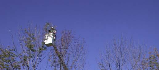
23 Current Survey Methods Sentinal Trap Trees Girdling Peeling at end of season Trapping Purple sticky traps Visual Survey A study was developed to test hyperspectral remote sensing
24 Main Question Can we use remote sensing technology to produce an accurate map of ash tree locations and health status over a large area?
25 2006 Airborne Data Collection Sanborn general contractor Panchromatic Imagery 0.25m spatial resolution LiDAR data 0.5m spatial resolution Hyperspectral Imagery 1m spatial resolution in the visible and near-infrared bands (SpecTIR( SpecTIR s AISA Eagle sensor) 1 st 2 nd st collection in June nd collection in late August

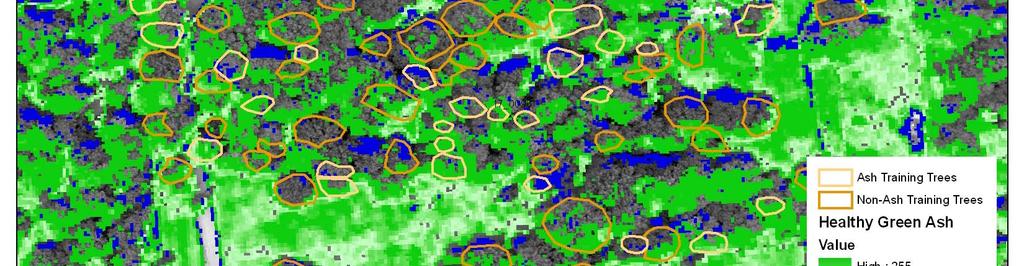
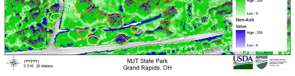
26 2006 Flight Area Locations 150 km 2 Northern Michigan Sites Boyne City Petoskey Central Michigan Sites Ann Arbor Napoleon Brooklyn Ohio Sites Toledo Oak Openings Grand Rapids
27 Analysis Groups Sanborn Remote Measurement Services (RMS) USDA FS & University of New Hampshire Clark Labs (Clark University) ITT Space Systems Division
28 RMS Analysis Hyperspectal Pixel Analysis RMS has conducted a pixel level analysis on both sets of hyperspectral data
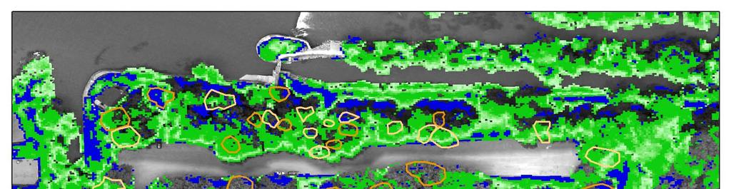
29 Hyperspectral Pixel Analysis Results - June GBC-Health Scores
30 Hyperspectral Pixel Analysis Results - August GBC-Health Scores Ann Arbor flight area Training Data # Trees Pixels Correct Trees Correct Green H= % 75.00% White H= % 66.70% H= % % H= % % H= % 83.30% H= % % Verification Data Green H= % 80.00% White H= % % H= % 50.00% H= % 40.00% H= % 25.00% H= % 66.70%
31 Hyperspectral Pixel Analysis Results - June GBC-Health Scores Average across all flight area Training Data # Trees Pixels Correct Min Max Trees Correct Min Max Green H= % 33.50% 82.10% 63.00% 38.50% 75.00% White H= % 0.00% 97.10% 47.56% 0.00% % Black H= % 78.60% 78.60% % % % H= % 13.80% 94.90% 52.11% 0.00% % H= % 0.00% 78.10% 58.34% 0.00% % H= % 61.50% 93.80% 87.77% 80.00% % H= % 75.80% % % % % Verification Data Green H= % 7.70% 61.30% 38.81% 0.00% 70.00% White H= % 46.70% % 69.03% 50.00% % Black H=1 0 H= % 0.00% 67.70% 33.46% 0.00% 70.00% H= % 9.70% 76.20% 50.63% 0.00% % H= % 18.00% 48.50% 8.33% 0.00% 25.00% H= % 0.00% 87.50% 66.67% 0.00% %
32 Further Analysis - EAB Complete the accuracy assessment for the hyperspectral pixel analysis on ash health and non ash Determine the effect of distance on training data Get results back from other analysis groups
33 Conclusions Spatial technology could be incorporated into almost every pest detection program GPS systems should be used to collect spatial location on pest survey data Aerial imagery is very useful in pest detection and survey programs Helps focus survey efforts and save resources Hyperspectral imaging technology holds great promise for improving pest survey and detection The challenge is moving the technology into an operational context. Remote sensing and global positioning technology can play a key role in the detection of many invasive pests


34 Acknowledgements Giant Salvinia Daniel Flores USDA APHIS PPQ Jim Everitt USDA ARS Citrus Greening Rich Somers USDA APHIS PPQ Stephen Tice LRGVDC Saltcedar Lisa Kennaway USDA APHIS PPQ Gerry Anderson USDA ARS Emerald Ash Borer Russell Sheetz USDA APHIS PPQ David Williams USDA APHIS PPQ David Cappaert Michigan State Univ. Deb McCullough Michigan State Univ.
35 Questions
History & Scope of Remote Sensing FOUNDATIONS
 History & Scope of Remote Sensing FOUNDATIONS Lecture Overview Introduction Overview of visual information Power of imagery Definition What is remote sensing? Definition standard for class History of Remote
Remote detection of giant reed invasions in riparian habitats: challenges and opportunities for management planning
 Remote detection of giant reed invasions in riparian habitats: challenges and opportunities for management planning Maria do Rosário Pereira Fernandes Forest Research Centre, University of Lisbon Number
Arthropod Containment in Plant Research. Jian J Duan & Jay Bancroft USDA ARS Beneficial Insects Research Unit Newark, Delaware
 Arthropod Containment in Plant Research Jian J Duan & Jay Bancroft USDA ARS Beneficial Insects Research Unit Newark, Delaware What we do at USDA ARS BIIRU - To develop biological control programs against
Using Remote Sensing to Map the Evolution of Marsh Vegetation in the South Bay of San Francisco
 Using Remote Sensing to Map the Evolution of Marsh Vegetation in the South Bay of San Francisco Brian Fulfrost Design, Community and Environment (DC&E) 6 th Annual Bay-Delta Science Conference PROJECT
GIS and Remote Sensing
 Spring School Land use and the vulnerability of socio-ecosystems to climate change: remote sensing and modelling techniques GIS and Remote Sensing Katerina Tzavella Project Researcher PhD candidate Technology
Remote Sensing and Geospatial Application for Wetlands Mapping, Assessment, and Mitigation
 Remote Sensing and Geospatial Application for Wetlands Mapping, Assessment, and Mitigation Hydrology Soils MSU Seminar Series Remote Sensing and Geospatial Applications September 4, 2002 Vegetation NEPA
Land Use MTRI Documenting Land Use and Land Cover Conditions Synthesis Report
 Colin Brooks, Rick Powell, Laura Bourgeau-Chavez, and Dr. Robert Shuchman Michigan Tech Research Institute (MTRI) Project Introduction Transportation projects require detailed environmental information
Advanced Image Analysis in Disaster Response
 Advanced Image Analysis in Disaster Response Creating Geographic Knowledge Thomas Harris ITT The information contained in this document pertains to software products and services that are subject to the
The Road to Data in Baltimore
 Creating a parcel level database from high resolution imagery By Austin Troy and Weiqi Zhou University of Vermont, Rubenstein School of Natural Resources State and local planning agencies are increasingly
SURVEY OF SUBMERGED NOXIOUS WEED SPECIES IN LAKE CHELAN WASHINGTON
 SURVEY OF SUBMERGED NOXOUS WEED SPECES N LAKE CHELAN WASHNGTON 1/26/215 Produced by AquaTechnex Lake Chelan was surveyed by air and by boat in the fall of 214 to locate noxious weeds and assess their overall
Wetland Mapping. Wetland Mapping in the United States. State Wetland Losses 53% in Lower US. Matthew J. Gray University of Tennessee
 Wetland Mapping Caribbean Matthew J. Gray University of Tennessee Wetland Mapping in the United States Shaw and Fredine (1956) National Wetlands Inventory U.S. Fish and Wildlife Service is the principle
Invasive Species Test. 30 Stations 90 seconds each -or- 15 stations (2/seat) 3 minutes each
 3 minutes each") Invasive Species Test 30 Stations 90 seconds each -or- 15 stations (2/seat) 3 minutes each Station 1 A. The insect transmits Huanglongbing killing the plant upon which it feeds. How was this species introduced
Invasive Species Test 30 Stations 90 seconds each -or- 15 stations (2/seat) 3 minutes each Station 1 A. The insect transmits Huanglongbing killing the plant upon which it feeds. How was this species introduced
Site Specific Management Center Newsletter, Purdue University, April,
 Using Spectral Vegetation Indices to Differentiate Weeds and Mint in Remote Sensing Images Mary Gumz and Stephen C. Weller Department of Horticulture and Landscape Architecture Introduction Remote sensing-based
Yrd. Doç. Dr. Saygın ABDİKAN Öğretim Yılı Güz Dönemi
 Yabancı Dil III (YDL285) Introduction to Geomatics Yrd. Doç. Dr. Saygın ABDİKAN 2017-2018 Öğretim Yılı Güz Dönemi 1 géomatique Geo (Earth) + informatics Geodesy + Geoinformatics Geomatics: The mathematics
Louisiana Transportation Engineering Conference. Monday, February 12, 2007
 Louisiana Transportation Engineering Conference Monday, February 12, 2007 Agenda Project Background Goal of EIS Why Use GIS? What is GIS? How used on this Project Other site selection tools I-69 Corridor
Spatial Process VS. Non-spatial Process. Landscape Process
 Spatial Process VS. Non-spatial Process A process is non-spatial if it is NOT a function of spatial pattern = A process is spatial if it is a function of spatial pattern Landscape Process If there is no
USING HYPERSPECTRAL IMAGERY
 USING HYPERSPECTRAL IMAGERY AND LIDAR DATA TO DETECT PLANT INVASIONS 2016 ESRI CANADA SCHOLARSHIP APPLICATION CURTIS CHANCE M.SC. CANDIDATE FACULTY OF FORESTRY UNIVERSITY OF BRITISH COLUMBIA CURTIS.CHANCE@ALUMNI.UBC.CA
Urban Tree Canopy Assessment Purcellville, Virginia
 GLOBAL ECOSYSTEM CENTER www.systemecology.org Urban Tree Canopy Assessment Purcellville, Virginia Table of Contents 1. Project Background 2. Project Goal 3. Assessment Procedure 4. Economic Benefits 5.
Weeds, Exotics or Invasives?
 Invasive Species Geography 444 Adopted from Dr. Deborah Kennard Weeds, Exotics or Invasives? What is a weed? Invasive species? 1 Weeds, Exotics or Invasives? Exotic or non-native: Non-native invasive pest
Lesson 4b Remote Sensing and geospatial analysis to integrate observations over larger scales
 Lesson 4b Remote Sensing and geospatial analysis to integrate observations over larger scales We have discussed static sensors, human-based (participatory) sensing, and mobile sensing Remote sensing: Satellite
Home About Us Articles Press Releases Image Gallery Contact Us Media Kit Free Subscription 10/5/2006 5:56:35 PM
 Home About Us Articles Press Releases Image Gallery Contact Us Media Kit Free Subscription 10/5/2006 5:56:35 PM Industry Resources Industry Directory NASA Links Missions/Launches Calendar Human development
Why Sample Vegetation? Vegetation Sampling. Vegetation Sampling Metrics. Enumeration and Density
 Vegetation Sampling Key concepts Types of vegetation sampling Methods of vegetation sampling Definitions Density Cover Growth Vigor Utilization Transect Macroplot Quadrat Physiological status Why Sample
Current and Future Technology Applications for Coastal Zone Management. Bruce K. Carlisle, Acting Director Office of Coastal Zone Management
 Current and Future Technology Applications for Coastal Zone Management Bruce K. Carlisle, Acting Director Office of Coastal Zone Management The Massachusetts Coastal Zone Management Program Approved in
Conservation and Recovery of Ione Endemic Plants: Mapping the Ione Plant Community
 Conservation and Recovery of Ione Endemic Plants: Mapping the Ione Plant Community Final Report Prepared for California Department of Fish and Game Contract and addendum September 1, 2004 Barbara Holzman,
Quick Response Report #126 Hurricane Floyd Flood Mapping Integrating Landsat 7 TM Satellite Imagery and DEM Data
 Quick Response Report #126 Hurricane Floyd Flood Mapping Integrating Landsat 7 TM Satellite Imagery and DEM Data Jeffrey D. Colby Yong Wang Karen Mulcahy Department of Geography East Carolina University
Gypsy Moth Geocoins. Virginia Geocoin Adventure Activity Guide and Project Reflections
 Developed by the: Virginia Geospatial Extension Program and VirginiaView Gypsy Moth Geocoins Virginia Geocoin Adventure Activity Guide and Project Reflections In this activity, your group will explore:
NERC Geophysical Equipment Facility - View more reports on our website at
 NERC GEOPHYSICAL EQUIPMENT FACILITY LOAN 877 SCIENTIFIC REPORT Modelling gap microclimates in broadleaved deciduous forests using remotely sensed data: the contribution of GPS to geometric correction and
History INVASIVE INSECTS THREATENING YOUR BACKYARD: BROWN MARMORATED STINK BUG & VIBURNUM LEAF BEETLE. Identification. Common Look-A-Likes 1/12/2015
 History INVASIVE INSECTS THREATENING YOUR BACKYARD: BROWN MARMORATED STINK BUG & VIBURNUM LEAF BEETLE Native to Asia First discovered in Pennsylvania, 1998 David R. Lance, USDA APHIS PPQ Adults emerge
Overview of Remote Sensing in Natural Resources Mapping
 Overview of Remote Sensing in Natural Resources Mapping What is remote sensing? Why remote sensing? Examples of remote sensing in natural resources mapping Class goals What is Remote Sensing A remote sensing
Role of GIS in Tracking and Controlling Spread of Disease
 Role of GIS in Tracking and Controlling Spread of Disease For Dr. Baqer Al-Ramadan By Syed Imran Quadri CRP 514: Introduction to GIS Introduction Problem Statement Objectives Methodology of Study Literature
Technical Drafting, Geographic Information Systems and Computer- Based Cartography
 Technical Drafting, Geographic Information Systems and Computer- Based Cartography Project-Specific and Regional Resource Mapping Services Geographic Information Systems - Spatial Analysis Terrestrial
Yanbo Huang and Guy Fipps, P.E. 2. August 25, 2006
 Landsat Satellite Multi-Spectral Image Classification of Land Cover Change for GIS-Based Urbanization Analysis in Irrigation Districts: Evaluation in Low Rio Grande Valley 1 by Yanbo Huang and Guy Fipps,
Remote Sensing, Computers, and Land Use Planning
 Purdue University Purdue e-pubs LARS Technical Reports Laboratory for Applications of Remote Sensing 1-1-1973 Remote Sensing, Computers, and Land Use Planning Harry C. Hitchcock Follow this and additional
Geospatial Technologies for the Agricultural Sciences
 Geospatial Technologies for the Agricultural Sciences Maggi Kelly Assoc. Cooperative Extension Specialist Department of Environmental Science, Policy & Management Director, GIIF UC Berkeley Karin Tuxen
GIS for Integrated Pest Management. Christina Hailey. Abstract:
 GIS for Integrated Pest Management Christina Hailey Abstract: At its formation in 1965, Harris County Mosquito Control (Houston, Texas) (HCMC) was primarily involved in the prevention and control of mosquito-borne
A Comprehensive Inventory of the Number of Modified Stream Channels in the State of Minnesota. Data, Information and Knowledge Management.
 A Comprehensive Inventory of the Number of Modified Stream Channels in the State of Minnesota Data, Information and Knowledge Management Glenn Skuta Environmental Analysis and Outcomes Division Minnesota
An Extraction and Accuracy Assessment of Dead Tree Using Object-Based Classification
 An Extraction and Accuracy Assessment of Dead Tree Using Object-Based Classification Kiyoung HONG, Yunsoo CHOI and Jaemyeong KIM, Republic of Korea Key words: Dead Tree Management, Object-Based Classification,
Southern California Edison Wildfire Mitigation & Grid Resiliency
 Southern California Edison Wildfire Mitigation & Grid Resiliency California State Legislative Conference Committee on Wildfire Preparedness and Response August 7, 2018 CALIFORNIA S WILDFIRE RISK Year-Round
Satellite Imagery: A Crucial Resource in Stormwater Billing
 Satellite Imagery: A Crucial Resource in Stormwater Billing May 10, 2007 Carl Stearns Engineering Technician Department of Public Works Stormwater Services Division Sean McKnight GIS Coordinator Department
It is one of the most serious oak diseases in the United States, killing thousands of trees each year.
 1 Oak Wilt is the disease caused by the pathogenic non-native fungus Ceratocystis fagacearum that affects oaks. Oaks in the red oak group (those with sharply pointed tips- like pin oak and red oak) are
15 Non-Native Plants at Lake Mead National Recreation Area
 15 Non-Native Plants at Lake Mead National Recreation Area To report weed locations use non-native plant survey form and/or contact: Carrie Norman Exotic Plant Manager carrie_norman@nps.gov 702-293-8734
SATELLITE REMOTE SENSING
 SATELLITE REMOTE SENSING of NATURAL RESOURCES David L. Verbyla LEWIS PUBLISHERS Boca Raton New York London Tokyo Contents CHAPTER 1. SATELLITE IMAGES 1 Raster Image Data 2 Remote Sensing Detectors 2 Analog
Mapping for a Changing California
 Mapping for a Changing California Spatial Data Science: - the 21 st century mapping toolkit - case studies in remote sensing and participatory informatics -where to get more information Maggi Kelly, University
Land Cover Classification Mapping & its uses for Planning
 Land Cover Classification Mapping & its uses for Planning What is Land Cover Classification Mapping? Examples of an actual product Why use Land Cover Classification Mapping for planning? Possible uses
Resolving habitat classification and structure using aerial photography. Michael Wilson Center for Conservation Biology College of William and Mary
 Resolving habitat classification and structure using aerial photography Michael Wilson Center for Conservation Biology College of William and Mary Aerial Photo-interpretation Digitizing features of aerial
identify tile lines. The imagery used in tile lines identification should be processed in digital format.
 Question and Answers: Automated identification of tile drainage from remotely sensed data Bibi Naz, Srinivasulu Ale, Laura Bowling and Chris Johannsen Introduction: Subsurface drainage (popularly known
Pierce Cedar Creek Institute GIS Development Final Report. Grand Valley State University
 Pierce Cedar Creek Institute GIS Development Final Report Grand Valley State University Major Goals of Project The two primary goals of the project were to provide Matt VanPortfliet, GVSU student, the
Aerial Photography and Imagery Resources Guide
 Aerial Photography and Imagery Resources Guide Cheyenne and Laramie County Cooperative GIS Created and Maintained by the GIS Coordinator for the Cooperative GIS Program May 2016 CHEYENNE / LARAMIE COUNTY
Minimum Standards for Wetland Delineations
 Minimum Standards for Wetland Delineations Jason Gipson Chief, Utah/Nevada Regulatory Branch Sacramento District Regulatory Program Workshop 16 Mar 2016 US Army Corps of Engineers Delineation Report Minimum
CadasterENV Sweden Time series in support of a multi-purpose land cover mapping system at national scale
 CadasterENV Sweden Time series in support of a multi-purpose land cover mapping system at national scale Mats Rosengren, Camilla Jönsson ; Metria AB Marc Paganini ; ESA ESRIN Background CadasterENV Sweden
Giant Salvinia Overview & History Restore America s Estuaries & The Coastal Society 2016 Summit December 15, 2016
 Giant Salvinia Overview & History Restore America s Estuaries & The Coastal Society 2016 Summit December 15, 2016 Jillian Day Aquatic Plant Control Coordinator Inland Fisheries Giant Salvinia Native to
ENVIRONMENT AND NATURAL RESOURCES 3700 Introduction to Spatial Information for Environment and Natural Resources. (2 Credit Hours) Semester Syllabus
 Semester Syllabus") ENVIRONMENT AND NATURAL RESOURCES 3700 Introduction to Spatial Information for Environment and Natural Resources COURSE INSTRUCTOR: Dr. Kris Jaeger Assistant Professor 359 Kottman Hall (Mondays and Tuesdays)
ENVIRONMENT AND NATURAL RESOURCES 3700 Introduction to Spatial Information for Environment and Natural Resources COURSE INSTRUCTOR: Dr. Kris Jaeger Assistant Professor 359 Kottman Hall (Mondays and Tuesdays)
Aerial Photograph-Based Pavement Surface Distress Detection and Evaluation
 Aerial Photograph-Based Pavement Surface Distress Detection and Evaluation César Hernández Gracia Antonio Sahuquillo Piñero AF2913-Road Construction and Maintenance Table of Contents 1. Introduction 2.
GEOMATICS. Shaping our world. A company of
 GEOMATICS Shaping our world A company of OUR EXPERTISE Geomatics Geomatics plays a mayor role in hydropower, land and water resources, urban development, transport & mobility, renewable energy, and infrastructure
UNMANNED AERIAL VEHICLE: GEOMORPHOLOGY STUDY
 UNMANNED AERIAL VEHICLE: GEOMORPHOLOGY STUDY Nattaporn Yuang-Ngoen Rapeeporn Samart This research aims to comparedata of Geomorphology from Unmanned Aerial Vehicle and field trips. The data for comparison
VISUALIZING THE SMART CITY 3D SPATIAL INFRASTRUCTURE GEOSMART ASIA- 30 SEP, 2015
 www.aamgroup.com VISUALIZING THE SMART CITY 3D SPATIAL INFRASTRUCTURE GEOSMART ASIA- 30 SEP, 2015 Agenda AAM What is a Smart City? Data Acquisition 3D Modelling Benefits Questions AAM AAM is a Geospatial
Geospatial Data, Services, and Products. National Surveying, mapping and geospatial conference
 Geospatial Data, Services, and Products Federal Programs -- USDA NRCS National Surveying, mapping and geospatial conference March 15, 2016 NRCS Applications using Geosaptial Products & Services Field
Kyoto and Carbon Initiative - the Ramsar / Wetlands International perspective
 Kyoto and Carbon Initiative - the Ramsar / Wetlands International perspective (the thoughts of Max Finlayson, as interpreted by John Lowry) Broad Requirements Guideline(s) for delineating wetlands (specifically,
Lecture 6 - Raster Data Model & GIS File Organization
 Lecture 6 - Raster Data Model & GIS File Organization I. Overview of Raster Data Model Raster data models define objects in a fixed manner see Figure 1. Each grid cell has fixed size (resolution). The
Accuracy Assessment of Pictometry Height Measurements Stratified by Cardinal Direction and Image Magnification Factor
 International Journal of Geospatial and Environmental Research Volume 3 Number 1 Article 4 August 2016 Accuracy Assessment of Pictometry Height Measurements Stratified by Cardinal Direction and Image Magnification
Quality Assessment of Shuttle Radar Topography Mission Digital Elevation Data. Thanks to. SRTM Data Collection SRTM. SRTM Galapagos.
 Quality Assessment of Shuttle Radar Topography Mission Digital Elevation Data Third International Conference on Geographic Information Science College Park, Maryland, October 20-23 Ashton Shortridge Dept.
AN INTEGRATED METHOD FOR FOREST CANOPY COVER MAPPING USING LANDSAT ETM+ IMAGERY INTRODUCTION
 AN INTEGRATED METHOD FOR FOREST CANOPY COVER MAPPING USING LANDSAT ETM+ IMAGERY Zhongwu Wang, Remote Sensing Analyst Andrew Brenner, General Manager Sanborn Map Company 455 E. Eisenhower Parkway, Suite
USING LANDSAT IN A GIS WORLD
 USING LANDSAT IN A GIS WORLD RACHEL MK HEADLEY; PHD, PMP STEM LIAISON, ACADEMIC AFFAIRS BLACK HILLS STATE UNIVERSITY This material is based upon work supported by the National Science Foundation under
ENV208/ENV508 Applied GIS. Week 1: What is GIS?
 ENV208/ENV508 Applied GIS Week 1: What is GIS? 1 WHAT IS GIS? A GIS integrates hardware, software, and data for capturing, managing, analyzing, and displaying all forms of geographically referenced information.
Mapping polar vegetation using UAS
 Mapping polar vegetation using UAS Stein Rune Karlsen, Agnar Sivertsen, Andreas Tøllefsen, Rune Storvold, Bernt Johansen Norut Northern Research Institute Anna Zmarz Warsaw University of Technology Content
Aerial Photography and Imagery Resources Guide
 Aerial Photography and Imagery Resources Guide Cheyenne and Laramie County Cooperative GIS Created and Maintained by the GIS Coordinator for the Cooperative GIS Program March 2011 CHEYENNE / LARAMIE COUNTY
Unit 1, Lesson 3 What Tools and Technologies Do Geographers Use?
 Unit 1, Lesson 3 What Tools and Technologies Do Geographers Use? Geographers use a variety of tools and technologies in investigating geographic questions. Maps and globes both represent the earth, but
PRINCIPLES OF PHOTO INTERPRETATION
 PRINCIPLES OF PHOTO INTERPRETATION Photo Interpretation the act of examining photographic images for the purpose of identifying objects and judging their significance an art more than a science Recognition
Emergency Planning. for the. Democratic National. Convention. imaging notes // Spring 2009 //
 Emergency Planning for the Democratic National Convention The DRAPP Demonstrates Partnership among Local, Regional, State, Utility and Federal Governments 14 imaging notes // Spring 2009 // www.imagingnotes.com
An Internet-based Agricultural Land Use Trends Visualization System (AgLuT)
") An Internet-based Agricultural Land Use Trends Visualization System (AgLuT) Prepared for Missouri Department of Natural Resources Missouri Department of Conservation 07-01-2000-12-31-2001 Submitted by
An Internet-based Agricultural Land Use Trends Visualization System (AgLuT) Prepared for Missouri Department of Natural Resources Missouri Department of Conservation 07-01-2000-12-31-2001 Submitted by
Quality Assurance Project Plan (QAPP) - Vegetation Survey of Huron Creek Houghton, MI
 - Vegetation Survey of Huron Creek Houghton, MI") Quality Assurance Project Plan (QAPP) - Vegetation Survey of Huron Creek Houghton, MI Prepared By: Linda D. Kersten, Dr. Alex S. Mayer Michigan Technological University, Center for Water & Society Prepared
Quality Assurance Project Plan (QAPP) - Vegetation Survey of Huron Creek Houghton, MI Prepared By: Linda D. Kersten, Dr. Alex S. Mayer Michigan Technological University, Center for Water & Society Prepared
Remote Sensing and GIS Techniques for Monitoring Industrial Wastes for Baghdad City
 The 1 st Regional Conference of Eng. Sci. NUCEJ Spatial ISSUE vol.11,no.3, 2008 pp 357-365 Remote Sensing and GIS Techniques for Monitoring Industrial Wastes for Baghdad City Mohammad Ali Al-Hashimi University
Airborne Multi-Spectral Minefield Survey
 Dirk-Jan de Lange, Eric den Breejen TNO Defence, Security and Safety Oude Waalsdorperweg 63 PO BOX 96864 2509 JG The Hague THE NETHERLANDS Phone +31 70 3740857 delange@fel.tno.nl ABSTRACT The availability
Remote Sensing Technologies For Mountain Pine Beetle Surveys
 Remote Sensing Technologies For Mountain Pine Beetle Surveys Michael Wulder and Caren Dymond Natural Resources Canada, Canadian Forest Service, Pacific Forestry Centre, 506 West Burnside Road, Victoria,
Purple Loosestrife Project Biocontrol Sites:
 Purple Loosestrife Project Biocontrol Sites: Interim results of a cooperative project between Michigan State University and Michigan Sea Grant Extension Photos, Maps and Layout by Jason K. Potter 2002
Anjana Dewanji, Anindita Chatterjee & Achyut Kumar Banerjee. Agricultural & Ecological Research Unit Indian Statistical Institute Kolkata, India
 Anjana Dewanji, Anindita Chatterjee & Achyut Kumar Banerjee Agricultural & Ecological Research Unit Indian Statistical Institute Kolkata, India World wide distribution Distribution in India Present scenario
This module presents remotely sensed assessment (choice of sensors and resolutions; airborne or ground based sensors; ground truthing)
") This module presents remotely sensed assessment (choice of sensors and resolutions; airborne or ground based sensors; ground truthing) 1 In this presentation you will be introduced to approaches for using
This module presents remotely sensed assessment (choice of sensors and resolutions; airborne or ground based sensors; ground truthing) 1 In this presentation you will be introduced to approaches for using
Application of GIS and remote sensing in conservation of vernal pools
 Priyanka Patel NRS 509 12/16/2014 Application of GIS and remote sensing in conservation of vernal pools Vernal pools are small temporary water bodies that contain water for some parts of the year. They
NR402 GIS Applications in Natural Resources. Lesson 9: Scale and Accuracy
 NR402 GIS Applications in Natural Resources Lesson 9: Scale and Accuracy 1 Map scale Map scale specifies the amount of reduction between the real world and the map The map scale specifies how much the
The following maps must be provided as a part of the ADA. The appropriate scale for each map should be determined at the pre application conference.
 Main Street @ Coconut Creek DRI QUESTION 9 MAPS The following maps must be provided as a part of the ADA. The appropriate scale for each map should be determined at the pre application conference. Map
USE OF RADIOMETRICS IN SOIL SURVEY
 USE OF RADIOMETRICS IN SOIL SURVEY Brian Tunstall 2003 Abstract The objectives and requirements with soil mapping are summarised. The capacities for different methods to address these objectives and requirements
Object-based classification of residential land use within Accra, Ghana based on QuickBird satellite data
 International Journal of Remote Sensing Vol. 28, No. 22, 20 November 2007, 5167 5173 Letter Object-based classification of residential land use within Accra, Ghana based on QuickBird satellite data D.
Mapping Soils, Crops, and Rangelands by Machine Analysis of Multi-Temporal ERTS-1 Data
 Purdue University Purdue e-pubs LARS Technical Reports Laboratory for Applications of Remote Sensing 1-1-1973 Mapping Soils, Crops, and Rangelands by Machine Analysis of Multi-Temporal ERTS-1 Data M. F.
3Chapter Three: Rescue and Response
 17 16 Report Science Title and the Storms: the USGS Response to the Hurricanes of 2005 3Chapter Three: Rescue and Response This chapter documents the U.S. Geological Survey s (USGS) humanitarian rescue
Investigating San Jose scale in northwest Michigan sweet cherries
 Investigating San Jose scale in northwest Michigan sweet cherries E. A. Pochubay and N. L. Rothwell Michigan State University Extension, AgBioResearch January 13-14, 2015 Northwest Michigan Orchard and
2018 NASCIO Award Submission Category: Cross-Boundary Collaboration and Partnerships. Project Title: Tennessee Wildfires: A Coordinated GIS Response
 2018 NASCIO Award Submission Category: Cross-Boundary Collaboration and Partnerships Project Title: Tennessee Wildfires: A Coordinated GIS Response Sevier County, Tennessee State of Tennessee, Emergency
UAV s in Geoinformatics - Trends and Perspectives
 UAV s in Geoinformatics - Trends and Perspectives Torsten Prinz & Christian Knoth Institute for Geoinformatics (IFGI), University of Muenster (WWU) GeoNetzwerk Münsterland (29.11.2013) I. Introduction
URBAN LAND COVER AND LAND USE CLASSIFICATION USING HIGH SPATIAL RESOLUTION IMAGES AND SPATIAL METRICS
 URBAN LAND COVER AND LAND USE CLASSIFICATION USING HIGH SPATIAL RESOLUTION IMAGES AND SPATIAL METRICS Ivan Lizarazo Universidad Distrital, Department of Cadastral Engineering, Bogota, Colombia; ilizarazo@udistrital.edu.co
Boreal Fen probability - metadata
 Boreal Fen probability - metadata FenProbabilityOS.tif FenOS.tif ABMI Geospatial Centre February, 2017 Photo credit Emily Upham-Mills and Bayne Lab 1 Contents 1. Overview... 3 1.1 Summary... 3 1.2 Description...
Remote Sensing of Wooded Species Prior to their Removal for Watershed Remediation
 Remote Sensing of Wooded Species Prior to their Removal for Watershed Remediation Daniel M. Lupton Remote Sensing Fall 2008 Term Project December 8, 2008 1 Abstract Juniperus ashei (Ashe Juniper) has overtaken
Hydric Rating by Map Unit Harrison County, Mississippi. Web Soil Survey National Cooperative Soil Survey
 89 9' 7'' W 89 8' 38'' W 30 34' 13'' N 30 33' 57'' N 3383480 3383560 3383640 3383720 3383800 3383880 3383960 293640 293720 293800 293880 293960 294040 294120 294200 294280 294360 3383480 3383560 3383640
Unit 1, Lesson 2. What is geographic inquiry?
 What is geographic inquiry? Unit 1, Lesson 2 Understanding the way in which social scientists investigate problems will help you conduct your own investigations about problems or issues facing your community
The Invasive Status of Giant Salvinia and Hydrilla in Mississippi
 Wilfredo Robles, John D. Madsen, Victor L. Maddox and Ryan M. Wersal GeoResources Institute Mississippi State University Box 9952 Starkville, MS 39762 662-325-2311 E-mail: wr40@pss.msstate.edu ABSTRACT
GEOGRAPHIC INFORMATION SYSTEMS
 GEOGRAPHIC INFORMATION SYSTEMS 4-H Round-Up Community Transitions Workshop Daniel Hanselka June 14, 2011 Goals of the Workshop Answer the question: What is GIS? Uses of GIS. Some of the Common Terminology
Land Administration and Cadastre
 Geomatics play a major role in hydropower, land and water resources and other infrastructure projects. Lahmeyer International s (LI) worldwide projects require a wide range of approaches to the integration
Third Annual Monitoring Report Tidal Wetland Restoration 159 Long Neck Point Road, Darien, CT NAE
 1) Project Overview Third Annual Monitoring Report Tidal Wetland Restoration 159 Long Neck Point Road, Darien, CT NAE-2007-1130 December 15, 2014 This is the third year of a five year monitoring program
Inventory of Ash Trees in Mahomet, Illinois
 Inventory of Ash Trees in Mahomet, Illinois East Central Illinois Master Naturalist Inventory of Ash Trees in Mahomet, Illinois The Advisory Board of the East Central Illinois Master Naturalists (ECIMN)
60 THE NORTHERN TORNADOES PROJECT OVERVIEW AND INITIAL RESULTS
 60 THE NORTHERN TORNADOES PROJECT OVERVIEW AND INITIAL RESULTS David Sills 1*, Gregory A. Kopp 2, Emilio Hong 2, Joanne Kennell 2, Aaron Jaffe 2, and Lesley Elliott 2 1 Meteorological Research Division,
ENVS S102 Earth and Environment (Cross-listed as GEOG 102) ENVS S110 Introduction to ArcGIS (Cross-listed as GEOG 110)
 ENVS S110 Introduction to ArcGIS (Cross-listed as GEOG 110)") ENVS S102 Earth and Environment (Cross-listed as GEOG 102) 1. Describe the fundamental workings of the atmospheric, hydrospheric, lithospheric, and oceanic systems of Earth 2. Explain the interactions
ENVS S102 Earth and Environment (Cross-listed as GEOG 102) 1. Describe the fundamental workings of the atmospheric, hydrospheric, lithospheric, and oceanic systems of Earth 2. Explain the interactions
o 3000 Hannover, Fed. Rep. of Germany
 1. Abstract The use of SPOT and CIR aerial photography for urban planning P. Lohmann, G. Altrogge Institute for Photogrammetry and Engineering Surveys University of Hannover, Nienburger Strasse 1 o 3000