Land cover research, applications and development needs in Slovakia
|
|
|
- Susan Baldwin
- 6 years ago
- Views:
Transcription

 Štefánikova 3, 814 99")
1 Land cover research, applications and development needs in Slovakia Andrej Halabuk Institute of Landscape Ecology Slovak Academy of Sciences (ILE SAS) Štefánikova 3, Bratislava, Slovakia

 ILE SAS covers fields of abiotic, biotic and")
2 Institute of Landscape Ecology Slovak Academy of Sciences Interdisciplinary scientific institution for basic and applied research in landscape ecology (established in 1965) Total staff: 59 (scientific staff: 39; PhD students: 7) ILE SAS covers fields of abiotic, biotic and socio-economic sciences
 Biodiversity and ecosystem research Long-term ecological research (time series analysis of NDVI for LSP and stress detection) Biodiversity assessment at landscape")
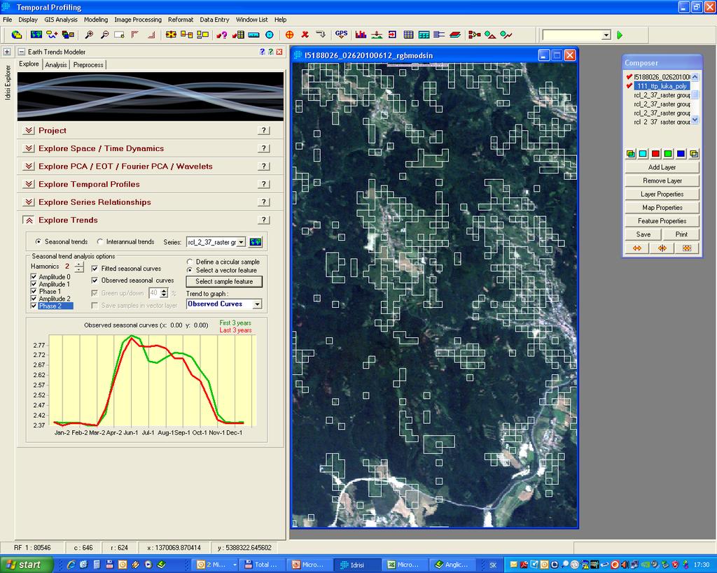
3 Research related to Remote Sensing Landscape ecology Land cover mapping and classification Habitat suitability modelling and predictive mapping Landscape structure analysis Land use and land cover change (detection and modelling) Biodiversity and ecosystem research Long-term ecological research (time series analysis of NDVI for LSP and stress detection) Biodiversity assessment at landscape scale Impact of climate variability on ecosystems


4 Linking Pan-European Land cover Change to Pressures on Biodiversity


5 DPSIR concept Land cover transitions during Main changes from extensive grassland to forest from mosaics to intensive grassland from mosaics to extensive grassland from mosaics to forest from shrub to forest Main changes Study area boundary Not changed Change Change Changes in both periods from ext. grassland to grassland with trees from extensive grassland to forest from grassland with trees to forest from shrub to forest


6 Predictive land cover change modelling 2003 Liberalization 2030 BAU 2030 Biodiversity 2030


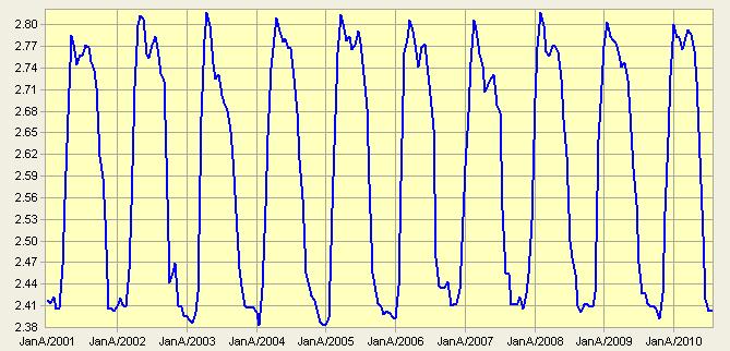
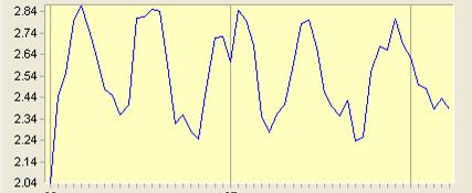
 Inter-seasonal variability (CV of annual")
7 Future development: From land cover change to land cover dynamics Land cover dynamics characterized by seasonal and inter-seasonal variability of vegetation greenness reflected in dynamic change of SI signal Annual mean of MAX NDVI from Response to increasing availability of SI Increasing temporal resolution (LDCM, Sentinel2,...) Result: multitemporal and time series based land cover classification and land cover dynamics analysis time series analysis of vegetation greenness (NDVI) Inter-seasonal variability (CV of annual MAX NDVI from ) Mean seasonality within season SD of MAX NDVI


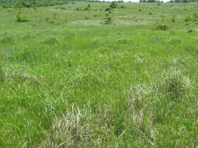
8 Grassland focus Using of NDVI time series for grassland monitoring Grasslands important component of landscape and its functioning (production, biodiversity, water retention) Lack of spatial statistics, difficult detection by RS Detection of management practice in grasslands (cutting, grazing, overgrowing, drying, flooding, burning)


9 Grasslands: 94 % accuracy Grasslands: 92 % accuracy Errors decreased dramatically after the crop harvesting in late June Accuracy decreased to 85% and 78% when using only 2 resp. 1 time period for the analysis


10 Grassland mapping in Slovakia Validat. set CLC 8d NDVI 16d NDVI Heterogeneous Prod. accuracy 38% 30% 30% User's accuracy 58% 58% 51% Homogenous Prod. accuracy 39% 68% 53% Intensive grasslands unmanaged grasslands User's accuracy 77,5% 61% 60% - Broader scale higher variability worse results - More effort needs for training - Phenology based classes needs to be defined - Still promising results compare to CLC flooded grasslands


 3.")
11 Classification of grasslands based on annual profile of NDVI 1. Slovak grassland sites (pure 3758 pixels) based on GE inspection and LPIS 2. Hungarian lowlands (N2000 grasslands - approx pure pixels GE inspection) 3. Slovak grasslands approx heterog. pixels without no check


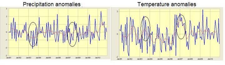
12 Land cover dynamics interaction with climate variability 2003 Median
13
14 Land cover dynamics detection - Mainly remote and mountainous areas - Further analysis needed including socioeconomic data - Possible consequences predictive modelling Number of years managed from

15 Land cover dynamics detection - Mainly remote and mountainous areas - Further analysis including socioeconomic data is needed - Possible consequences predictive modelling Number of years unmanaged from
16 unmanaged managed 1 Further analysis including socioeconomic data is needed

17 Future needs Network of field validation sites (including land management data) at regional scale Developing techniques for up-scaling between sites, networks of sites for detecting and interpreting key indicators of land use and land cover change Designing a system for a cost effective monitoring that enable frequent, repeated, regionally coordinated assessment of distribution, status and trends of landscape and ecosystems
Greening of Arctic: Knowledge and Uncertainties
 Greening of Arctic: Knowledge and Uncertainties Jiong Jia, Hesong Wang Chinese Academy of Science jiong@tea.ac.cn Howie Epstein Skip Walker Moscow, January 28, 2008 Global Warming and Its Impact IMPACTS
Chitra Sood, R.M. Bhagat and Vaibhav Kalia Centre for Geo-informatics Research and Training, CSK HPKV, Palampur , HP, India
 APPLICATION OF SPACE TECHNOLOGY AND GIS FOR INVENTORYING, MONITORING & CONSERVATION OF MOUNTAIN BIODIVERSITY WITH SPECIAL REFERENCE TO MEDICINAL PLANTS Chitra Sood, R.M. Bhagat and Vaibhav Kalia Centre
LAND COVER CATEGORY DEFINITION BY IMAGE INVARIANTS FOR AUTOMATED CLASSIFICATION
 LAND COVER CATEGORY DEFINITION BY IMAGE INVARIANTS FOR AUTOMATED CLASSIFICATION Nguyen Dinh Duong Environmental Remote Sensing Laboratory Institute of Geography Hoang Quoc Viet Rd., Cau Giay, Hanoi, Vietnam
UK Contribution to the European CORINE Land Cover
 Centre for Landscape andwww.le.ac.uk/clcr Climate Research CENTRE FOR Landscape and Climate Research UK Contribution to the European CORINE Land Cover Dr Beth Cole Corine Coordination of Information on
Object Oriented Classification Using High-Resolution Satellite Images for HNV Farmland Identification. Shafique Matin and Stuart Green
 Object Oriented Classification Using High-Resolution Satellite Images for HNV Farmland Identification Shafique Matin and Stuart Green REDP, Teagasc Ashtown, Dublin, Ireland Correspondence: shafique.matin@teagasc.ie
SIF_7.1_v2. Indicator. Measurement. What should the measurement tell us?
 Indicator 7 Area of natural and semi-natural habitat Measurement 7.1 Area of natural and semi-natural habitat What should the measurement tell us? Natural habitats are considered the land and water areas
Remote Sensing for Ecosystems
 MODULE GUIDE MSc ENR Remote Sensing for Ecosystems Semester 01 Modul coordinator Lecturers Michael Döring Pascal Ochsner, Diego Tonolla, Diane Whited, Michael Döring Martin Geilhausen Latest update August
Earth s Major Terrerstrial Biomes. *Wetlands (found all over Earth)
") Biomes Biome: the major types of terrestrial ecosystems determined primarily by climate 2 main factors: Depends on ; proximity to ocean; and air and ocean circulation patterns Similar traits of plants
Biomes Biome: the major types of terrestrial ecosystems determined primarily by climate 2 main factors: Depends on ; proximity to ocean; and air and ocean circulation patterns Similar traits of plants
ANALYSIS AND VALIDATION OF A METHODOLOGY TO EVALUATE LAND COVER CHANGE IN THE MEDITERRANEAN BASIN USING MULTITEMPORAL MODIS DATA
 PRESENT ENVIRONMENT AND SUSTAINABLE DEVELOPMENT, NR. 4, 2010 ANALYSIS AND VALIDATION OF A METHODOLOGY TO EVALUATE LAND COVER CHANGE IN THE MEDITERRANEAN BASIN USING MULTITEMPORAL MODIS DATA Mara Pilloni
Spatiotemporal variations of alpine climate, snow cover and phenology
 Spatiotemporal variations of alpine climate, snow cover and phenology S. Asam, M. Callegari, M. Matiu, G. Fiore, L. De Gregorio, A. Jacob, A. Menzel, C. Notarnicola, M. Zebisch Asam et al., Spatiotemporal
Patrick Leinenkugel. German Aerospace Center (DLR) Vortrag > Autor > Dokumentname > Datum
 Vortrag > Autor > Dokumentname > Datum") Characterisation of land surface phenology and land cover for the Mekong Basin on the basis of multitemporal and multispectral satellite data from the MODIS Sensor Patrick Leinenkugel German Aerospace
Characterisation of land surface phenology and land cover for the Mekong Basin on the basis of multitemporal and multispectral satellite data from the MODIS Sensor Patrick Leinenkugel German Aerospace
Multi-temporal remote sensing for spatial estimation of Plant Available Water holding Capacity (PAWC)
") NDVI Time Geosmart Asia Locate 18 9 11 April 2018 Multi-temporal remote sensing for spatial estimation of Plant Available Water holding Capacity (PAWC) Sofanit Araya Bertram Ostendorf Gregory Lyle Megan
NDVI Time Geosmart Asia Locate 18 9 11 April 2018 Multi-temporal remote sensing for spatial estimation of Plant Available Water holding Capacity (PAWC) Sofanit Araya Bertram Ostendorf Gregory Lyle Megan
EAGLE Data Model and Outcomes of HELM (Harmonised European Land Monitoring)
") EAGLE Data Model and Outcomes of HELM (Harmonised European Land Monitoring) Contribution towards better land information harmonisation and INSPIRE compliance EAGLE working group Stephan Arnold, Barbara
EAGLE Data Model and Outcomes of HELM (Harmonised European Land Monitoring) Contribution towards better land information harmonisation and INSPIRE compliance EAGLE working group Stephan Arnold, Barbara
Green areas: numerous positive effects for sustainable metropolis Satellite images : an easy way to map vegetation
 Green areas: numerous positive effects for sustainable metropolis Satellite images : an easy way to map vegetation Copernicus Training and Information Session 10 and 11 may 2017 in Lund, Sweden Dominique
Spanish national plan for land observation: new collaborative production system in Europe
 ADVANCE UNEDITED VERSION UNITED NATIONS E/CONF.103/5/Add.1 Economic and Social Affairs 9 July 2013 Tenth United Nations Regional Cartographic Conference for the Americas New York, 19-23, August 2013 Item
Note on Definition of Socio-Ecological Landscape Unit, SELU Classification and its Policy Application
 Note on Definition of Socio-Ecological Landscape Unit, SELU Classification and its Policy Application Alessandra Alfieri, Daniel Clarke and Ivo Havinga, United Nations Statistics Division and Jean Louis
Ecosystems Chapter 4. What is an Ecosystem? Section 4-1
 Ecosystems Chapter 4 What is an Ecosystem? Section 4-1 Ecosystems Key Idea: An ecosystem includes a community of organisms and their physical environment. A community is a group of various species that
Ecosystem Disturbance and
 Remote Sensing of Forest Health: Ecosystem Disturbance and Recovery Tracker (edart) Region 5 Remote Sensing Lab Michèle Slaton, Alex Koltunov, Carlos Ramirez edart Overview A group of automated and interactive
Biomes and Ecosystems
 Name Biomes and Ecosystems Date How do Earth s biomes and ecosystems differ? Before You Read Before you read the chapter, think about what you know about biomes and ecosystems Record your thoughts in the
Vegetation Remote Sensing
 Vegetation Remote Sensing Huade Guan Prepared for Remote Sensing class Earth & Environmental Science University of Texas at San Antonio November 2, 2005 Outline Why do we study vegetation remote sensing?
Leveraging Sentinel-1 time-series data for mapping agricultural land cover and land use in the tropics
 Leveraging Sentinel-1 time-series data for mapping agricultural land cover and land use in the tropics Caitlin Kontgis caitlin@descarteslabs.com @caitlinkontgis Descartes Labs Overview What is Descartes
EAGLE concept, as part of the HELM vision
 EAGLE concept, as part of the HELM vision EAGLE working group Barbara Kosztra (Hungary), Stephan Arnold (Germany), Lena Hallin-Pihlatie & Elise Järvenpää (Finland) 16.06.2014 HELM / EAGLE Workshop - INSPIRE
Chapter 7 Part III: Biomes
 Chapter 7 Part III: Biomes Biomes Biome: the major types of terrestrial ecosystems determined primarily by climate 2 main factors: Temperature and precipitation Depends on latitude or altitude; proximity
Monitoring of Tropical Deforestation and Land Cover Changes in Protected Areas: JRC Perspective
 Monitoring of Tropical Deforestation and Land Cover Changes in Protected Areas: JRC Perspective Z. Szantoi, A. Brink, P. Mayaux, F. Achard Monitoring Of Natural resources for DEvelopment (MONDE) Joint
Lecture 24 Plant Ecology
 Lecture 24 Plant Ecology Understanding the spatial pattern of plant diversity Ecology: interaction of organisms with their physical environment and with one another 1 Such interactions occur on multiple
Rating of soil heterogeneity using by satellite images
 Rating of soil heterogeneity using by satellite images JAROSLAV NOVAK, VOJTECH LUKAS, JAN KREN Department of Agrosystems and Bioclimatology Mendel University in Brno Zemedelska 1, 613 00 Brno CZECH REPUBLIC
Derivation of phenometrics from high resolution RapidEye imagery of semi-arid grasslands in South Africa
 André Parplies Student Research Colloquium Derivation of phenometrics from high resolution RapidEye imagery of semi-arid grasslands in South Africa Introduction Introduction Study area Methodology Results
Monitoring Land Cover and Land Use in Central Asia Remote Sensing Contributions from selected German projects
 Monitoring Land Cover and Land Use in Central Asia Remote Sensing Contributions from selected German projects NASA LCLUC Meeting, Tashkent, 11.-13.11.2013 Christopher Conrad University of Würzburg, Institute
Habitats habitat concept, identification, methodology for habitat mapping, organization of mapping
 Habitats habitat concept, identification, methodology for habitat mapping, organization of mapping Rastislav Lasák & Ján Šeffer Training Implementation of Habitats Directive - Habitats and Plants 1 What
Remote sensing monitoring of land restoration interventions in semi-arid environments
 MultiTemp 2017 Remote sensing monitoring of land restoration interventions in semi-arid environments M. Meroni 1, A. Schucknecht 1, D. Fasbender 1, F. Rembold 1, L. di Lucchio 1,5, F. Fava 2, M. Mauclaire
Urban remote sensing: from local to global and back
 Urban remote sensing: from local to global and back Paolo Gamba University of Pavia, Italy A few words about Pavia Historical University (1361) in a nice town slide 3 Geoscience and Remote Sensing Society
Remote Sensing products and global datasets. Joint Research Centre, European Commission
 Remote Sensing products and global datasets Joint Research Centre, European Commission Setting the stage. Needs and requirements for integrated approach(es) for land degradation assessment. in Special
The Role of EO Consultants and SMEs within GMES. Geoff Smith
 The Role of EO Consultants and SMEs within GMES Geoff Smith Enable clients to deliver useful, accurate and reliable environmental information from EO. Positioned to bridge the gaps between technology development,
Mapping and Assessment of Ecosystems and their Services
 Mapping and Assessment of Ecosystems and their Services ALTER-Net Conference 2013: Science underpinning the EU 2020 Biodiversity Strategy. April 2013 Gent Joachim MAES 1 This presentation is based on the
Application of Remote Sensing Techniques for Change Detection in Land Use/ Land Cover of Ratnagiri District, Maharashtra
 IOSR Journal of Applied Geology and Geophysics (IOSR-JAGG) e-issn: 2321 0990, p-issn: 2321 0982.Volume 3, Issue 6 Ver. II (Nov. - Dec. 2015), PP 55-60 www.iosrjournals.org Application of Remote Sensing
A Small Migrating Herd. Mapping Wildlife Distribution 1. Mapping Wildlife Distribution 2. Conservation & Reserve Management
 A Basic Introduction to Wildlife Mapping & Modeling ~~~~~~~~~~ Rev. Ronald J. Wasowski, C.S.C. Associate Professor of Environmental Science University of Portland Portland, Oregon 8 December 2015 Introduction
MODELLING LAND USE CHANGE ON A REGIONAL SCALE
 MODELLING LAND USE CHANGE ON A REGIONAL SCALE W. Lahmer 1, A. Becker 1, B. Pfützner 2 1 Potsdam Institute for Climate Impact Research, Telegrafenberg, D-14412 Potsdam, Germany 2 Bureau for Applied Hydrology
SEEA Experimental Ecosystem Accounting
 SEEA Experimental Ecosystem Accounting Sokol Vako United Nations Statistics Division Training for the worldwide implementation of the System of Environmental Economic Accounting 2012 - Central Framework
Student Name: Teacher: Date: District: London City. Assessment: 07 Science Science Test 4. Description: Life Science Final 1.
 Student Name: Teacher: Date: District: London City Assessment: 07 Science Science Test 4 Description: Life Science Final 1 Form: 301 1. A food chain is shown. Sunlight Grass Rabbit Snake What is the abiotic
«Desertification and Drought Monitoring in Arid Tunisia based on Remote Sensing Imagery» Research Undertaken & Case-Studies.
 «Desertification and Drought Monitoring in Arid Tunisia based on Remote Sensing Imagery» Research Undertaken & Case-Studies EU COST Action September 2015, Antalya Turkey Bouajila ESSIFI INSTITUT DES REGIONS
APPENDIX. Normalized Difference Vegetation Index (NDVI) from MODIS data
 from MODIS data") APPENDIX Land-use/land-cover composition of Apulia region Overall, more than 82% of Apulia contains agro-ecosystems (Figure ). The northern and somewhat the central part of the region include arable lands
APPENDIX Land-use/land-cover composition of Apulia region Overall, more than 82% of Apulia contains agro-ecosystems (Figure ). The northern and somewhat the central part of the region include arable lands
Accounting Units for Ecosystem Accounts Paper prepared by Alessandra Alfieri, Daniel Clarke, and Ivo Havinga United Nations Statistics Division
 DEPARTMENT OF ECONOMIC AND SOCIAL AFFAIRS STATISTICS DIVISION UNITED NATIONS Expert Meeting on Ecosystem Accounts London, UK 5-7 December 2011 Accounting Units for Ecosystem Accounts Paper prepared by
Capabilities and Limitations of Land Cover and Satellite Data for Biomass Estimation in African Ecosystems Valerio Avitabile
 Capabilities and Limitations of Land Cover and Satellite Data for Biomass Estimation in African Ecosystems Valerio Avitabile Kaniyo Pabidi - Budongo Forest Reserve November 13th, 2008 Outline of the presentation
1.1 Draw one line from each adaptation of the fennec fox to the advantage of the. To reflect the sun s rays
 4-7 Ecology Trilogy.0 Figure shows a fennec fox. Figure Fennec foxes live in the desert. Drew Avery Creative Commons 2.0. Draw one line from each adaptation of the fennec fox to the advantage of the adaptation.
Introduction. Ecology is the scientific study of the interactions between organisms and their environment.
 Introduction Ecology is the scientific study of the interactions between organisms and their environment. 1. The interactions between organisms and their environments determine the distribution and abundance
Most people used to live like this
 Urbanization Most people used to live like this Increasingly people live like this. For the first time in history, there are now more urban residents than rural residents. Land Cover & Land Use Land cover
Our Living Planet. Chapter 15
 Our Living Planet Chapter 15 Learning Goals I can describe the Earth s climate and how we are affected by the sun. I can describe what causes different climate zones. I can describe what makes up an organisms
CadasterENV Sweden Time series in support of a multi-purpose land cover mapping system at national scale
 CadasterENV Sweden Time series in support of a multi-purpose land cover mapping system at national scale Mats Rosengren, Camilla Jönsson ; Metria AB Marc Paganini ; ESA ESRIN Background CadasterENV Sweden
An Update on Land Use & Land Cover Mapping in Ireland
 An Update on Land Use & Land Cover Mapping in Ireland Progress Towards a National Programme Kevin Lydon k.lydon@epa.ie Office of Environmental Assessment, Environmental Protection Agency, Johnstown Castle,
LUCAS: current product and its evolutions
 LUCAS: current product and its evolutions Workshop Land Use and Land Cover products: challenges and opportunities Brussels 15 Nov 2017 Eurostat E4: estat-dl-lucas@ec.europa.eu Contents 1) The context 2)
Seasonal and interannual relations between precipitation, soil moisture and vegetation in the North American monsoon region
 Seasonal and interannual relations between precipitation, soil moisture and vegetation in the North American monsoon region Luis A. Mendez-Barroso 1, Enrique R. Vivoni 1, Christopher J. Watts 2 and Julio
of a landscape to support biodiversity and ecosystem processes and provide ecosystem services in face of various disturbances.
 L LANDSCAPE ECOLOGY JIANGUO WU Arizona State University Spatial heterogeneity is ubiquitous in all ecological systems, underlining the significance of the pattern process relationship and the scale of
The LISA extension to INSPIRE LC/LU data model: The Austrian experience
 The LISA extension to INSPIRE LC/LU data model: The Austrian experience Gebhard Banko, Environment Agency Austria Roland Grillmayer, Environment Agency Austria Wolfgang Stemberger, GeoVille INSPIRE KEN
European Topic Centre on Land Urban and Soil Systems. Green Infrastructure at EEA
 Green Infrastructure at EEA A SPATIAL APPROACH TO MAPPING GI Stefan Kleeschulte, ETC ULS GI and territorial cohesion 2011 first EEA report on Green Infrastructure Underlining the need to develop tools
Transboundary water management with Remote Sensing. Oluf Jessen DHI Head of Projects, Water Resources Technical overview
 Transboundary water management with Remote Sensing Oluf Jessen DHI Head of Projects, Water Resources Technical overview ozj@dhigroup.com Transboundary water management Water management across national
UNSD SEEA-EEA revision 2020
 UNSD SEEA-EEA revision 2020 Area 1: Spatial units; introduction Sjoerd Schenau, Patrick Bogaart, Edwin Horlings London group meeting, October 2018 Overview Spatial units in SEEA EEA Main revision issues
Biomes Section 1. Chapter 6: Biomes Section 1: What is a Biome? DAY ONE
 Chapter 6: Biomes Section 1: What is a Biome? DAY ONE What is a Biome? Biomes are large regions characterized by a specific type of climate and certain types of plant and animal communities. The climate
MAPPING URBAN GREEN SPACES BASED ON REMOTE SENSING DATA: CASE STUDIES IN BULGARIA AND SLOVAKIA
 MAPPING URBAN GREEN SPACES BASED ON REMOTE SENSING DATA: CASE STUDIES IN BULGARIA AND SLOVAKIA Rumiana Vatseva, Monika Kopecka, Jan Otahel, Konstantin Rosina, Atanas Kitev, Stefan Genchev Prof. Rumiana
Module 2.1 Monitoring activity data for forests using remote sensing
 Module 2.1 Monitoring activity data for forests using remote sensing Module developers: Frédéric Achard, European Commission (EC) Joint Research Centre (JRC) Jukka Miettinen, EC JRC Brice Mora, Wageningen
Regionalized and application-specific compositing - a review of requirements, opportunities and challenges
 Regionalized and application-specific compositing - a review of requirements, opportunities and challenges Patrick Griffiths & Patrick Hostert Geography Department, Humboldt University Berlin Joanne White
NASA EARTH EXCHANGE (NEX)
") NASA EARTH EXCHANGE (NEX) Enabling Interdisciplinary Research nex.nasa.gov Uttam Kumar and Ramakrishna Nemani NASA Ames Research Center, Moffett Field, CA. The need for collaborative research - NEX Massive
NASA EARTH EXCHANGE (NEX) Enabling Interdisciplinary Research nex.nasa.gov Uttam Kumar and Ramakrishna Nemani NASA Ames Research Center, Moffett Field, CA. The need for collaborative research - NEX Massive
Agricultural land-use from space. David Pairman and Heather North
 Agricultural land-use from space David Pairman and Heather North Talk Outline Motivation Challenges Different approach Paddock boundaries Classifications Examples Accuracy Issues Data sources Future possibilities
Discuss the impact of biotic and abiotic factors on their environment and the significant ecological levels of organization.
 Learning Targets Discuss the impact of biotic and abiotic factors on their environment and the significant ecological levels of organization. Explain the difference between an organism s habitat and niche
REMOTE SENSING ACTIVITIES. Caiti Steele
 REMOTE SENSING ACTIVITIES Caiti Steele REMOTE SENSING ACTIVITIES Remote sensing of biomass: Field Validation of Biomass Retrieved from Landsat for Rangeland Assessment and Monitoring (Browning et al.,
forest tropical jungle swamp marsh prairie savanna pampas Different Ecosystems (rainforest)
") Different Ecosystems forest A region of land that is covered with many trees and shrubs. tropical jungle (rainforest) swamp A region with dense trees and a variety of plant life. It has a tropical climate.
Different Ecosystems forest A region of land that is covered with many trees and shrubs. tropical jungle (rainforest) swamp A region with dense trees and a variety of plant life. It has a tropical climate.
K&C Phase 4 Status report. Use of short-period ALOS-2 observations for vegetation characterization and classification
 K&C Phase 4 Status report Use of short-period ALOS-2 observations for vegetation characterization and classification Paul Siqueira, Tracy Whelen University of Massachusetts, Amherst Yang Lei NASA JPL Science
Suitability Mapping For Locating Special Economic Zone
 Suitability Mapping For Locating Special Economic Zone by Sudhir Gupta, Vinay Pandit, K.S.Rajan in Remote Sensing and Photogrammetry Society Conference, 5-7 September 2008, Falmouth, United Kingdom Report
Climate Change and Arizona s Rangelands: Management Challenges and Opportunities
 Climate Change and Arizona s Rangelands: Management Challenges and Opportunities Mike Crimmins Climate Science Extension Specialist Dept. of Soil, Water, & Env. Science & Arizona Cooperative Extension
System of Environmental-Economic Accounting. Advancing the SEEA Experimental Ecosystem Accounting. Extent Account (Levels 1 and 2)
") Advancing the SEEA Experimental Ecosystem Accounting Extent Account (Levels 1 and 2) Overview: The Extent Account 1. Learning objectives 2. Review of Level 0 (5m) What is it? Why do we need it? What does
Advancing the SEEA Experimental Ecosystem Accounting Extent Account (Levels 1 and 2) Overview: The Extent Account 1. Learning objectives 2. Review of Level 0 (5m) What is it? Why do we need it? What does
THE OVERALL EAGLE CONCEPT
 Sentinel Hub THE OVERALL EAGLE CONCEPT GEBHARD BANKO, 30. MAY 2018, COPENHAGEN ISO TC 211, STANDARDS IN ACTION SEMINAR CONTENT Background and Motivation Criteria and Structure of Data Model Semantic decomposition
Ryan Baum, MS Candidate, ISU Matthew Germino, Assistant Professor, ISU
 Spatial and temporal variation in remotely sensed vegetation indices on the INEEL from 1984-2002 Ryan Baum, MS Candidate, ISU Matthew Germino, Assistant Professor, ISU Importance How does vegetation vary
AGOG 485/585 /APLN 533 Spring Lecture 5: MODIS land cover product (MCD12Q1). Additional sources of MODIS data
. Additional sources of MODIS data") AGOG 485/585 /APLN 533 Spring 2019 Lecture 5: MODIS land cover product (MCD12Q1). Additional sources of MODIS data Outline Current status of land cover products Overview of the MCD12Q1 algorithm Mapping
AGOG 485/585 /APLN 533 Spring 2019 Lecture 5: MODIS land cover product (MCD12Q1). Additional sources of MODIS data Outline Current status of land cover products Overview of the MCD12Q1 algorithm Mapping
Name Hour. Chapter 4 Review
 Name Hour Chapter 4 Review 1. The average, year-after-year conditions of temperature and precipitation within a particular region are its weather. climate. greenhouse effect. d. biotic factors. 2. The
Comparison of MSG-SEVIRI and SPOT-VEGETATION data for vegetation monitoring over Africa
 Comparison of MSG-SEVIRI and SPOT-VEGETATION data for vegetation monitoring over Africa Bernard LACAZE CNRS UMR 8586 PRODIG Pôle Image et Campus Spatial, Université Paris Diderot Paris 7 Objectives Comparison
GLOBWETLAND AFRICA TOOLBOX
 The GlobWetland Africa Toolbox is an open source and free-of-charge software toolbox for inventorying, mapping, monitoring and assessing wetlands. The toolbox comes with end-to-end processing workflows
Global Patterns Gaston, K.J Nature 405. Benefit Diversity. Threats to Biodiversity
 Biodiversity Definitions the variability among living organisms from all sources, including, 'inter alia', terrestrial, marine, and other aquatic ecosystems, and the ecological complexes of which they
Environments and Ecosystems
 Environments and Ecosystems A habitat is a place where organisms naturally live and grow. Habitats include biotic, living factors, such as plants and animals and abiotic, non-living factors, such as rocks,
EVALUATION OF AVHRR NDVI FOR MONITORING INTRA-ANNUAL AND INTERANNUAL VEGETATION DYNAMICS IN A CLOUDY ENVIRONMENT (SCOTLAND, UK)
") EVALUATION OF AVHRR NDVI FOR MONITORING INTRA-ANNUAL AND INTERANNUAL VEGETATION DYNAMICS IN A CLOUDY ENVIRONMENT (SCOTLAND, UK) S. Brand a,, T.J. Malthus b a Institute of Photogrammetry and Remote Sensing,
EVALUATION OF AVHRR NDVI FOR MONITORING INTRA-ANNUAL AND INTERANNUAL VEGETATION DYNAMICS IN A CLOUDY ENVIRONMENT (SCOTLAND, UK) S. Brand a,, T.J. Malthus b a Institute of Photogrammetry and Remote Sensing,
L A N D C O P E R N I C U S. Den Haag, Land Monitoring
 C O P E R N I C U S M O N I T O R I N G L A N D S E R V I C E Den Haag, 13.06.2018 hans.dufourmont@eea.europa.eu W A A R O M EEN C O P E R N I C U S L A N D M O N I T O R I N G D I E N S T? C O P E R N
INTERNATIONAL JOURNAL OF GEOMATICS AND GEOSCIENCES Volume 4, No 2, 2013
 INTERNATIONAL JOURNAL OF GEOMATICS AND GEOSCIENCES Volume 4, No 2, 2013 Copyright 2010 All rights reserved Integrated Publishing services Research article ISSN 0976 4380 Evaluation of landuse / landcover
This is trial version
 Journal of Rangeland Science, 2012, Vol. 2, No. 2 J. Barkhordari and T. Vardanian/ 459 Contents available at ISC and SID Journal homepage: www.rangeland.ir Full Paper Article: Using Post-Classification
4/18/2006 Olga N. Krankina, OSU
 (Northern Eurasia Landcover Dynamics Analysis) Monitoring and validating the distribution and change in land cover across Northern Eurasia Objectives Characterize land cover and its change across boreal
Copernicus Land HRL Imperviousness: 2012 dataset, indicator Title
 Copernicus Land HRL Imperviousness: 2012 dataset, 06-09 indicator and outlook Title 2015+ Tobias LANGANKE First name SURNAME Project manager, Copernicus Position land services Name European of the Environment
DROUGHT ASSESSMENT USING SATELLITE DERIVED METEOROLOGICAL PARAMETERS AND NDVI IN POTOHAR REGION
 DROUGHT ASSESSMENT USING SATELLITE DERIVED METEOROLOGICAL PARAMETERS AND NDVI IN POTOHAR REGION Researcher: Saad-ul-Haque Supervisor: Dr. Badar Ghauri Department of RS & GISc Institute of Space Technology
Applications of GIS and Remote Sensing for Analysis of Urban Heat Island
 Chuanxin Zhu Professor Peter V. August Professor Yeqiao Wang NRS 509 December 15, 2016 Applications of GIS and Remote Sensing for Analysis of Urban Heat Island Since the last century, the global mean surface
Season Spotter: Using Citizen Science to Validate and Scale Plant Phenology from Near-Surface Remote Sensing
 Season Spotter: Using Citizen Science to Validate and Scale Plant Phenology from Near-Surface Remote Sensing The Harvard community has made this article openly available. Please share how this access benefits
State-of-play... The EAGLE concept conceptual basis for a future European Land Monitoring Framework
 State-of-play... The EAGLE concept conceptual basis for a future European Land Monitoring Framework Stephan Arnold, Geir-H. Strand, Barbara Kosztra, Tomas Soukup, Gebhard Banko, Gerard Hazeu, Geoff Smith,
Overview on Land Cover and Land Use Monitoring in Russia
 Russian Academy of Sciences Space Research Institute Overview on Land Cover and Land Use Monitoring in Russia Sergey Bartalev Joint NASA LCLUC Science Team Meeting and GOFC-GOLD/NERIN, NEESPI Workshop
The Wide Dynamic Range Vegetation Index and its Potential Utility for Gap Analysis
 Summary StatMod provides an easy-to-use and inexpensive tool for spatially applying the classification rules generated from the CT algorithm in S-PLUS. While the focus of this article was to use StatMod
Environmental Changes, Migration, and Remittances Affect Pastoralist Communities in Montane Central Asia
 Environmental Changes, Migration, and Remittances Affect Pastoralist Communities in Montane Central Asia Geoffrey M. Henebry * Hannah Visiting Professor Center for Global Change & Earth Observations &
Lecture 1: What is Ecology? Why it is important for NRM?
 Lecture 1: What is Ecology? Why it is important for NRM? The three inter-related global challenges to sustainable development Sustainability Major components: Environmental Economic Social Political Why
Discussion paper on spatial units
 Discussion paper on spatial units for the Forum of Experts in SEEA Experimental Ecosystem Accounting 2018 Version: 8 June 2018 Prepared by: SEEA EEA Revision Working Group 1 on spatial units (led by Sjoerd
The Relationship between Vegetation Changes and Cut-offs in the Lower Yellow River Based on Satellite and Ground Data
 Journal of Natural Disaster Science, Volume 27, Number 1, 2005, pp1-7 The Relationship between Vegetation Changes and Cut-offs in the Lower Yellow River Based on Satellite and Ground Data Xiufeng WANG
Kyoto and Carbon Initiative - the Ramsar / Wetlands International perspective
 Kyoto and Carbon Initiative - the Ramsar / Wetlands International perspective (the thoughts of Max Finlayson, as interpreted by John Lowry) Broad Requirements Guideline(s) for delineating wetlands (specifically,
UNIT 5: ECOLOGY Chapter 15: The Biosphere
 CORNELL NOTES Directions: You must create a minimum of 5 questions in this column per page (average). Use these to study your notes and prepare for tests and quizzes. Notes will be stamped after each assigned
Evaluation of estimated satellite images for filling data gaps in an intra-annual high spatial resolution time-series
 Evaluation of estimated satellite images for filling data gaps in an intra-annual high spatial resolution time-series Tobias Schmidt, Michael Förster, Birgit Kleinschmit Technical University Berlin, Geoinformation
Remote sensing technique to monitoring the risk of soil degradation using NDVI
 Remote sensing technique to monitoring the risk of soil degradation using NDVI Ahmed Asaad Zaeen Remote sensing Unit, College of Science, University of Baghdad, Iraq ahmed_a_z@scbaghdad.com Abstract. In
Understanding landscape metrics. The link between pattern and process.
 Understanding landscape metrics The link between pattern and process. Roadmap Introduction Methodological considerations Spatial autocorrelation Stationarity Processes Abiotic Biotic Anthropogenic Disturbances
Land cover/land use mapping and cha Mongolian plateau using remote sens. Title. Author(s) Bagan, Hasi; Yamagata, Yoshiki. Citation Japan.
 Bagan, Hasi; Yamagata, Yoshiki. Citation Japan.") Title Land cover/land use mapping and cha Mongolian plateau using remote sens Author(s) Bagan, Hasi; Yamagata, Yoshiki International Symposium on "The Imp Citation Region Specific Systems". 6 Nove Japan.
Title Land cover/land use mapping and cha Mongolian plateau using remote sens Author(s) Bagan, Hasi; Yamagata, Yoshiki International Symposium on "The Imp Citation Region Specific Systems". 6 Nove Japan.