Inter-institutional and Intergovernmental Arrangements: MIDAS and the Caribbean Tsunami Warning System
|
|
|
- Hugo Burke
- 5 years ago
- Views:
Transcription


1 Inter-institutional and Intergovernmental Arrangements: MIDAS and the Caribbean Tsunami Warning System Christa G. von Hillebrandt-Andrade Manager NOAA NWS Caribbean Tsunami Warning Program Vice Chair UNESCO IOC CARIBE EWS Researcher on Leave from the PRSN, Geology Dept., UPRM Geophysical Hazards and Plate Boundary Processes in Central America, Mexico and the Caribbean Heredia, Costa Rica October, 2010
2 Indeed the January 12, 2010 and the tragedy of our Haitian brothers and sisters was a grim reminder to us all that much more effort is needed to construct earthquake resilient societies, protecting lives, property and livelihood throughout our region, and the challenge this poses to seismic networks and institutions
3 Challenges and Issues Seismic networks play a critical role in being the seismic conscience of a country. Seismic networks are the local champions for seismic risk reduction. Span the terms of office of our political leaders The best service is that which can be provided the closest possible to its customers, nevertheless, not all nations, countries, commonwealths and territories in the Caribbean and Adjacent regions (of which there are 43) have a 24 x 7 capability to acquire and analyze seismic, sea level and other data to generate timely and possibly life critical products on earthquakes and tsunamis, but all can have a capability to receive and disseminate these products. For a tsunami warning system, an early earthquake warning system, the interaction between the service provider and the decision maker in each of the 43 jurisdictions is very important before, during and after a tsunami event. Capacity building is critical whether for the operation, management and usage of seismic data. Meetings and workshops are great for building the human network (trust among networks) and also exposing operators to emerging technologies, opportunities and research. Academic training is key to integrating these into operations. The engagement with the media is key as they are our bridge to the decision makers and the general public. Research provides credibility to our operations, as well as the foundation for DRR.
4 MIDAS: International Interinstitutional Arrangement Consortium established 20 years ago in 1990 Gerardo Suarez (UNAM), Carlos Mendoza (USGS), Federico Guendell (OVSICORI), Eduardo Camacho (UPA), Margaret Wiggins (EU), David Novello (UNAM), Gustavo Malave (FUNVISIS), Michael Schmitz (FUNVISIS), Bruce Presgrave (USGS) Situation: Outside of the handful of GSN stations, there were no locally operated broad band stations, no/limited exchange of data information between seismic networks and a need for capacity building and strengthening seismic research Objectives: Promote the advancement of broadband instrumentation Coordinate the exchange of earthquake information, phase data, fullwaveform data Increase technical and scientific capabilities Provide a forum for scientific research
5 MIDAS Accomplishments Signatories: ISU (Dom. Republic), CASC, INDRHI (Dom. Republic), UNAH, CENAIS (Cuba), FUNVISIS, FUNISA, NEIC, OVSICORI, IG-UNAM, INETER, SRU, EU (Jamaica), PRSN, INGEOMINAS,CICESE. Held meetings (Puerto Rico, Jamaica, Florida) Installed the TEIG and UPA broad band stations in Yucatan and Panama Published the seismicity map of the MIDAS region Established a website with an online catalogue of earthquake locations Most important of all: Created a network of operators of seismic stations throughout the Caribbean
6 Other Accomplishments Digital data acquisition and processing at all networks. It can take a minute or two to locate an earthquake There are almost 100 permanent broadband stations in the region Almost every network has a platform for real time data exchange. Many earthquake professionals in the region, and colleagues outside of our region seeking collaboration. Exciting research
7 Challenges for MIDAS Networks and Research advanced, MIDAS fizzled No or extremely little funding, not that we did not try Commitments made at workshops and meetings that were not kept ( synchronization in asynchronization or not know where we should have put the fences ) Priorities and focus of energy of members were on the advancement (survival) of local seismic network operations, not on regional efforts No operational pressure, enforced deliverables (eg. from a grant), just good will No governmental commitment/engagement to the Consortium New projects (eg. Caribbean Tsunami Warning System) arose that to a degree replaced MIDAS

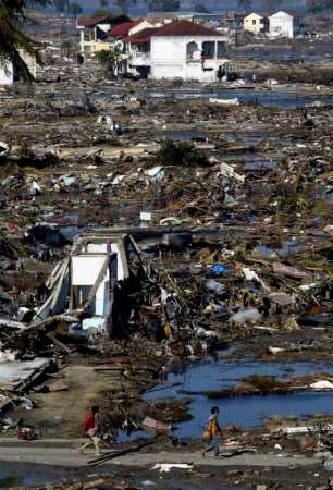
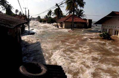
8 Tsunami INDONESIA, December 26, 2004, Mw 9.3


9 UNESCO IOC Intergovernmental Coordination Group for Tsunamis and Other Coastal Hazards Warning System for the Caribbean and Adjacent Regions CARIBE EWS The intergovernmental response established in 2006

10 Historical Tsunami Runups in the Caribbean 40 definite tsunamis, 10 probable tsunamis, 33 questionable tsunamis, 14 very doubtful tsunamis and 1seiche.

11 Since 1842, at least 3510 people have lost their lives to tsunamis, this is more than in the Northeastern Pacific The Caribbean basin in only 1/5 the area had nearly 6x more deaths! : deaths : 579 deaths


12 The Caribbean Situation Last major tsunami event(s): Dominican Republic: = 1865* deaths in August, Since 1946, explosive population growth across Caribbean from residents and tourists at the coasts Therefore, the Caribbean s historical deaths from tsunamis greatly understates its current 21 st century potential loss of life! If we just take into consideration the number of people that can be on the beach, 50,000 people are exposed daily to tsunamis in the region. The Basin has many tsunami-genic areas: tectonic zones & faults, shelves-trenches, volcanoes *Statistics from Caribbean Tsunamis, A 500- Year History from by Karen Fay O'Loughlin and James F. Lander (ISBN edition)
13 Main Components of CARIBE EWS Per recommendation of the Member States Working Groups: Monitoring and Tsunami Warning Guidance Tsunami Hazard, Risk and Vulnerability Assessments Communications Preparedness, Readiness and Resilience Permanent Bodies Caribbean Tsunami Warning Center-CTWP potential first step Caribbean Tsunami Information Center to be established in Barbados with funding by the Govt. of Italy Secretariat-Interim location in Paris, France at UNESCO HQ National Stakeholders National Tsunami Contacts Tsunami Warning Focal Points 13

14 Tsunami Warning System What is it?
15 Recommendations of ICG CARIBE EWS for Seismic Monitoring Establish Performance Criteria and Requirements for seismic stations Each Tsunami National Contact (Government official) has been requested to identify the contact point within the country for seismic, sea level and other observational data Develop a training plan for station operators Urges member states to upgrade and/or install GPS stations and consider collocation with seismic and sea level stations
16 Cont. Further Recommendations Urges Member States and other stakeholders to provide funding to support the acquisition, installation, maintenance and operation of core seismic and sea level stations contributing data to meet the full needs of the CARIBE-EWS and strengthen the communication systems of the monitoring centres exchanging data with the warning centres to ensure data availability;
17 Cont. Further Recommendations Welcomes the Memorandum of Cooperation between the CTBTO and IOC to facilitate the access of primary and secondary data to the CARIBE-EWS; Encourages that the continuous seismic data be sent to global data centres to facilitate research to improve the understanding of the seismic hazards;
18 ICG CARIBE EWS Mission statement for the Caribbean Tsunami Warning Center (CTWC) approved June, 2009 The CTWC will provide a timely and effective detection and analysis (forecast) of seismic events and tsunamis, conduct research and dissemination of tsunami watch, warnings and advisory products, as well as provide support for education, outreach and training to the Caribbean countries, states, territories and Adjacent Regions.


19 CTWC Providing regional service, strengthening local capabilities NOAA NWS established in February 1, 2010 the Caribbean Tsunami Warning Program, jointly located at the Puerto Rico Seismic Network at the University of Puerto Rico at Mayagüez as a 1rst step of the U.S. towards the establishment of a Caribbean Tsunami Warning Centre. When will the Program become a Centre? Funds are appropriated Upon CARIBE EWS recommendation ICG VI will consider further contributions of MS to the establishment of a Regional Tsunami Warning Center
20 Seismic Data Availability in the Caribbean 68% (63/93) of Core CARIBE EWS Stations in the Caribbean are contributing in real time. There are an additional 26 stations from the Atlantic and 7 from the Pacific 8 (9%) 5 (5%) Contributing 17 (18%) Existing 63 (68%) Planned Gap

21 Real time seismic data availability at PRSN


. 25% 90.000-100.")


22 Data availability for the contributing stations at PRSN 09/01/ /30/2010 (including Caribbean, Atlantic and Pacific stations). 25% % 1% 1% 2% 2% 57% % 6% %

23 CARIBE EWS IRIS Virtual Seismic Network
. 22% 90.000-10.")


24 Data availability at IRIS 09/1/ /30/2010 (including Caribbean, Atlantic and Caribbean). 22% % 0% 0% 0% 1% 1% 1% 4% % Recommendations for siting of stations focused on strategic placing Of stations on land masses, should we not be considering OBS s


25 CARIBE WAVE LANTEX 2011, March 23, 2011 Tsunami generated by a 7.5 earthquake in the US Virgin Island Basin (similar to the 1867 VI EQ and Tsunami)
26 Way Forward New generation of operators of seismic networks and earthquake centers challenged to keep building/strengthen seismological collaboration and capacity. NOAA/NWS and ICG CARIBE EWS will be very receptive to your recommendations and strategies as you are a cornerstone to a successful tsunami warning system Seismological Society of America invites you to join this organization of earthquake professionals


27 Working together to save lives, property and livelihood Reuters 2004-Thailand Haiti Americana Samoa 2009 Chile, 2010 Thank you Haiti NY Times christa.vonh@noaa.gov


28 More information NOAA NWS Caribbean Tsunami Warning Program, Tel , Puerto Rico Seismic Network PRTWMP with PR Tsunami Inundation Maps UNESCO IOC Caribe EWS
29 Challenges and Issues Seismic networks play a critical role in being the seismic conscience of a country. Seismic networks are the local champions for seismic risk reduction. Span the terms of office of our political leaders The best service is that which can be provided the closest possible to its customers, nevertheless, not all nations, countries, commonwealths and territories in the Caribbean and Adjacent regions (of which there are 43) have a 24 x 7 capability to acquire and analyze seismic, sea level and other data to generate timely and possibly life critical products on earthquakes and tsunamis, but all can have a capability to receive and disseminate these products. For a tsunami warning system, an early earthquake warning system, the interaction between the service provider and the decision maker in each of the 43 jurisdictions is very important before, during and after a tsunami event. Capacity building is critical whether for the operation, management and usage of seismic data. Meetings and workshops are great for building the human network (trust among networks) and also exposing operators to emerging technologies and research. Academic training is key to integrating emerging technologies and research into operations. The engagement with the media is key as they are our bridge to the decision makers and the general public. Research provides credibility to our operations, as well as the foundation for DRR.
30 Seismic Station Requirements of ICG CARIBE EWS approved June, 2009


; Tsunamis of the Eastern US, NGDC, 2002")
31 Date Place Fatalities 1842 Haiti Venezuela Virgin Islands Panama Jamaica Puerto Rico Dominican Republic(1) Dominican Republic(2) Haiti 7 TOTAL 3510 Ref: Caribbean Tsunamis, A 500-Year History from by Karen Fay O'Loughlin and James F. Lander (2003: ISBN ); Tsunamis of the Eastern US, NGDC, 2002 Science of Tsunami Hazards, vol 20, #3, pg 120; PRSN on Haiti,2010
Status of Real Time Broadband Seismic Monitoring in the Caribbean and Adjacent Regions
 Status of Real Time Broadband Seismic Monitoring in the Caribbean and Adjacent Regions Special presentation prepared by Christa G. von Hillebrandt for FDSN meeting, South Africa, 2009 Introductory Remarks
US Tsunami Services for PR and the VI: An Update from the NOAA NWS Caribbean Tsunami Warning Program
 U.S. National Oceanic and Atmospheric Administration National Weather Service Caribbean Tsunami Warning Program US Tsunami Services for PR and the VI: An Update from the NOAA NWS Caribbean Tsunami Warning
Puerto Rico Tsunami Mitigation and Warning Program: Update and Future
 Puerto Rico Tsunami Mitigation and Warning Program: Update and Future Christa G. von Hillebrandt- Andrade, Puerto Rico Seismic Network, UPRM Aurelio Mercado Dept. Marine Sciences, UPRM Status in 1999,
SOP of PTWC as a Regional Tsunami Service Provider
 UNESCO IOC CTIC US NOAA ITIC Regional Training Workshop on Strengthening Tsunami Warning and Emergency Response Standard Operating Procedures and the Development of the ICG/CARIBE-EWS PTWC New Enhanced
JCOMM-CHy Coastal Inundation Forecasting Demonstration Project (CIFDP)
") WMO World Meteorological Organization Working together in weather, climate and water JCOMM-CHy Coastal Inundation Forecasting Demonstration Project (CIFDP) Coastal Flooding & Vulnerable Populations Coastal
WMO World Meteorological Organization Working together in weather, climate and water JCOMM-CHy Coastal Inundation Forecasting Demonstration Project (CIFDP) Coastal Flooding & Vulnerable Populations Coastal
PRELIMINARY AGENDA. President IRIS Consortium Introduction of the Speaker Dr. Olga Cabello
 PRELIMINARY AGENDA Sunday October 24 18:00 Networking Reception 19:30 Dinner 20:30 Welcome and Opening Address Call to order Dr. Olga Cabello Welcome Dr. Marino Protti Opening Remarks Dr. David Simpson
Progress in building an end-to-end Tsunami Early Warning and Mitigation System
 Progress in building an end-to-end Tsunami Early Warning and Mitigation System International Forum on Tsunami and Earthquake Progress from the Hyogo Framework for Action 15/16 Jan 2007 Kobe, Japan Dr.
"Outcomes of the storm surge and waves workshop in Dominican Republic and the questionnaire"
 "Outcomes of the storm surge and waves workshop in Dominican Republic and the questionnaire" Strengthening Regional Cooperation to Support Forecasting with Multi Hazard Approach in RA IV Ritz Carlton Grand
Coastal Inundation Forecasting Demonstration Project CIFDP. Flood Forecasting Initiative-Advisory Group (FFI-AG 3), Geneva, 5-7 Dec, 2017
, Geneva, 5-7 Dec, 2017") Coastal Inundation Forecasting Demonstration Project CIFDP Flood Forecasting Initiative-Advisory Group (FFI-AG 3), Geneva, 5-7 Dec, 2017 Coastal Flooding & Vulnerable Populations Coastal populations are
Coastal Inundation Forecasting Demonstration Project CIFDP Flood Forecasting Initiative-Advisory Group (FFI-AG 3), Geneva, 5-7 Dec, 2017 Coastal Flooding & Vulnerable Populations Coastal populations are
Establishment and Operation of a Regional Tsunami Warning Centre
 Establishment and Operation of a Regional Tsunami Warning Centre Dr. Charles McCreery, Director NOAA Richard H. Hagemeyer Pacific Tsunami Warning Center Ewa Beach, Hawaii USA Why A Regional Tsunami Warning
ACTION PLAN FOR WORLD HERITAGE IN LATIN AMERICA AND THE CARIBBEAN ( )
") Annex ACTION PLAN FOR WORLD HERITAGE IN LATIN AMERICA AND THE CARIBBEAN (2014-2024) The current Regional Action Plan for Latin America and the Caribbean for 2014-2024 has been elaborated by the State Parties
Annex ACTION PLAN FOR WORLD HERITAGE IN LATIN AMERICA AND THE CARIBBEAN (2014-2024) The current Regional Action Plan for Latin America and the Caribbean for 2014-2024 has been elaborated by the State Parties
Incorporation of the Caribbean to the Geocentric Reference System for the Americas SIRGAS
 Incorporation of the Caribbean to the Geocentric Reference System for the Americas SIRGAS W. Martínez M. V. Mackern V. Cioce R. Rodino S.R. De Freitas UN-GGIM: Americas Third Session, October 5 2016, Mexico
ASSOCIATION OF CARIBBEAN STATES (ACS / AEC)
") ASSOCIATION OF CARIBBEAN STATES (ACS / AEC) 1 SHOCS (Strengthening Hydrometorological Operations and Services in Caribbean SIDS) The ACS/Finnish Government response to Hydrometorological risk in Caribbean
ASSOCIATION OF CARIBBEAN STATES (ACS / AEC) 1 SHOCS (Strengthening Hydrometorological Operations and Services in Caribbean SIDS) The ACS/Finnish Government response to Hydrometorological risk in Caribbean
17 th Session of RA IV
 17 th Session of RA IV Agenda Item 4.1: Disaster Risk Reduction, Resilience and Prevention, Focusing on Impact-Based Decision Support Services Doc 4.1.(6):Coastal Inundation Forecasting Demonstration Project
INTERNATIONAL HYDROGRAPHIC ORGANIZATION MESO AMERICAN & CARIBBEAN SEA HYDROGRAPHIC COMMISSION
 INTERNATIONAL HYDROGRAPHIC ORGANIZATION MESO AMERICAN & CARIBBEAN SEA HYDROGRAPHIC COMMISSION CAPACITY BUILDING PLAN Programme document for the period 2010-2012 1. INTRODUCTION 1.1. Rationale It is estimated
Executive Summary and Recommendations
 ANNEX I: EXECUTIVE SUMMARY AND RECOMMENDATIONS OF THE 12RMSD TWELFTH REGIONAL MEETING OF THE METEOROLOGICAL SERVICE DIRECTORS 30 -JUNE to 6 -JULY 2007 Rarotonga, Cook Islands Executive Summary and Recommendations
Briefing. H.E. Mr. Gyan Chandra Acharya
 Briefing by H.E. Mr. Gyan Chandra Acharya Under-Secretary-General and High Representative for the Least Developed Countries, Landlocked Developing Countries and Small Island Developing States Briefing
Haiti: Earthquake on January 12, 2010
 Geophysical Hazards and Plate Boundary Processes In Central America, Mexico and the Caribbean Haiti: Earthquake on January 12, 2010 Situation, achievements and perspective. Hotel La Condesa, Costa Rica
Advantages of Regional and Global Data Exchange. Gavin Hayes U.S. Geological Survey, National Earthquake Information Center
 Advantages of Regional and Global Data Exchange Gavin Hayes U.S. Geological Survey, National Earthquake Information Center USGS NEIC Global Earthquake Response Area of responsibility => Global BUT - domestically,
the IRIS Consortium Collaborative, Multi-user Facilities for Research and Education Briefing NSF Business Systems Review September 9, 2008
 the IRIS Consortium Collaborative, Multi-user Facilities for Research and Education Briefing NSF Business Systems Review September 9, 2008 A facilities program for collection and distribution of seismological
GEO Geohazards Community of Practice
 GEO Geohazards Community of Practice 1) Co-Chair of GHCP With input from: Stuart Marsh, GHCP Co-Chair Francesco Gaetani, GEO Secretariat and many GHCP contributors 1) Nevada Bureau of Mines and Geology
Meeting July 2018 Agenda Item 7.1. Tsunami Service Provider Messages for the Maritime Community. Submitted by IOC Secretariat SUMMARY
 WWNWS WWNWS10/7/1 Meeting 10 19 July 2018 Agenda Item 7.1 Tsunami Service Provider Messages for the Maritime Community Submitted by IOC Secretariat SUMMARY Executive Summary: This document provides details
Indian Ocean Tsunami Warning System: Example from the 12 th September 2007 Tsunami
 Indian Ocean Tsunami Warning System: Example from the 12 th September 2007 Tsunami Charitha Pattiaratchi 1 Professor of Coastal Oceanography, The University of Western Australia Email: chari.pattiaratchi@uwa.edu.au
Lessons Learned from Past Tsunamis Warning and Emergency Response
 UNESCO IOC CTIC US NOAA ITIC Regional Training Workshop on Strengthening Tsunami Warning and Emergency Response Standard Operating Procedures and the Development of the ICG/CARIBE-EWS PTWC New Enhanced
THE PHENOMENON WE CALL A TSUNAMI
 THE PHENOMENON WE CALL A TSUNAMI Dr. Victor Huérfano PUERTO RICO UNIVERSITY MAYAGUEZ CAMPUS GEOLOGY PUERTO RICO SEISMIC NETWORK WHAT IS A TSUNAMI? Global Distribution of Tsunamis 1410 BC AD 2011 NOAA
The ITSU System in the Pacific Region and Future Upgrades
 The ITSU System in the Pacific Region and Future Upgrades Eddie Bernard Director, Pacific Marine Environmental Laboratory (PMEL) NOAA/USA Pacific Tsunami Warning Center OPERATIONAL ACTIVITIES SEISMIC DATA
The Continuously Operation Caribbean Observational Network: COCONet
 The Continuously Operation Caribbean Observational Network: COCONet Glen S. Mattioli University of Texas at Arlington Presenting for COCONet Executive Committee: M. Miller(1), E. Calais(2), C. Meertens(1),
UN-GGIM:Americas Regional Report
 UN-GGIM:Americas Regional Report 2016-2017 Seventh Session of UN-GGIM 2-4 August 2017, United Nations Headquarters, New York. Rolando Ocampo President of UN-GGIM: Americas Content Activities, Areas of
Coastal Inundation Forecasting Demonstration Project (CIFDP)
") WMO World Meteorological Organization Working together in weather, climate and water Coastal Inundation Forecasting Demonstration Project (CIFDP) WMO Technical Commission for Oceanography and Marine Meteorology
WMO World Meteorological Organization Working together in weather, climate and water Coastal Inundation Forecasting Demonstration Project (CIFDP) WMO Technical Commission for Oceanography and Marine Meteorology
Crisis Support and Disaster Response. in Latin America and the Caribbean
 Crisis Support and Disaster Response in Latin America and the Caribbean The Pan American Agenda 2010-2020 of the Pan American Institute of Geography and History (PAIGH), and the resulting 2010 Implementation
Emergency Alerting Policy NOAA s National Weather Service
 Emergency Alerting Policy NOAA s National Weather Service OASIS, ITU, WMO, Environment Canada, Public Safety Canada, Centre for Security Sciences (Canada) Common Alerting Protocol (CAP) Emergency Alerting
2018/1 The integration of statistical and geospatial information. The Regional Committee of UN-GGIM: Americas:
 The following are the conclusions and recommendations of the Regional Committee of the United Nations on Global Geospatial Information Management for the Americas, during its Fifth Session, Thursday 8
ICG ACTIVITIES FOR NORTHEASTERN ATLANTIC, MEDITERRANEAN AND CONNECTED SEAS
 ICG ACTIVITIES FOR NORTHEASTERN ATLANTIC, MEDITERRANEAN AND CONNECTED SEAS The ICG/NEAMTWS was established as subsidiary body of the IOC, at the 23rd Session of the IOC Assembly in June 2005 through the
Economic and Social Council
 United Nations Economic and Social Council Distr.: General 18 July 2016 Original: English Committee of Experts on Global Geospatial Information Management Sixth session New York, 3-5 August 2016 Item 2
Dr. Steven Koch Director, NOAA National Severe Storms Laboratory Chair, WRN Workshop Executive Committee. Photo Credit: Associated Press
 Dr. Steven Koch Director, NOAA National Severe Storms Laboratory Chair, WRN Workshop Executive Committee 1 Photo Credit: Associated Press 1" 2" Much%Increased%Vulnerability%to% High6Impact%Weather% %even%before%2011!%
Unidata Policy Committee
 Unidata Policy Committee Weather-Ready Nation Saving Lives and Livelihoods May 21, 2014 LeRoy Spayd NOAA/NWS 1 Outline Weather Ready Nation NOAA Budget AWIPS 2 Algorithm Verification study National Water
GENERAL RECOMMENDATIONS. Session 7. Breakout discussion. discuss on regional and interregional. proposals 1. COLLABORATION BETWEEN PROGRAMMES
 Session 7 24 July 2016, 9.00-11.00 Breakout discussion on regional and interregional joint project proposals Mr Shahbaz Khan summarized the two days of presentations and exchanges and requested the participants
SCIENCE OF TSUNAMI HAZARDS
 SCIENCE OF TSUNAMI HAZARDS ISSN 8755-6839 Journal of Tsunami Society International Volume 32 Number 1 2013 THE FRENCH TSUNAMI WARNING CENTER FOR THE MEDITERRANEAN AND NORTHEAST ATLANTIC: CENALT P. Roudil,
Publishable Summary. Summary Description of the project context and main objectives
 Publishable Summary Summary Description of the project context and main objectives Tsunamis are low frequency but high impact natural disasters. In 2004, the Boxing Day tsunami killed hundreds of thousands
Applied Geoscience and Technology Division SOPAC. Joy Papao, Risk Information Systems Officer
 Joy Papao, Risk Information Systems Officer Secretariat of the Pacific Community SPC 22 Pacific Island States Head office in Noumea, New Caledonia 2 Regional offices (Pohnpei and Honiara) 600 staff 9 Technical
Please give me the background details of the warning system the US had before and the new improvements now.
 ----- Original Message ----- From: VADM Conrad C. Lautenbacher Jr., USN (Ret.) To: Announcement@noaa.gov Sent: Friday, January 28, 2005 1:30 PM Subject: Message from the Under Secretary -- NOAA Tsunami
WELCOME TO THE 2018 RA-IV WORKSHOP ON HURRICANE FORECASTING AND WARNING
 WELCOME TO THE 2018 RA-IV WORKSHOP ON HURRICANE FORECASTING AND WARNING Richard J. Pasch and Daniel P. Brown Senior Hurricane Specialists National Hurricane Center ORIENTATION Use of PCs NHC Facility Workshop
Tsunami Response and the Enhance PTWC Alerts
 Tsunami Response and the Enhance PTWC Alerts Ken Gledhill GeoNet Project Director Chair, Intergovernmental Coordination Group, Pacific Tsunami Warning and Mitigation System (PTWS) Overview 1. Procedures
Report of the Working Group 2 Data Sharing and Integration for Disaster Management *
 UNITED NATIONS E/CONF.104/6 ECONOMIC AND SOCIAL COUNCIL Twentieth United Nations Regional Cartographic Conference for Asia and the Pacific Jeju, 6-9 October 2015 Item 5 of the provisional agenda Report
Report for 15th PCGIAP Meeting at 18th UNRCC-AP Working Group 1 Regional Geodesy
 Report for 15th PCGIAP Meeting at 18th UNRCC-AP Working Group 1 Regional Geodesy Chairman Shigeru Matsuzaka, Japan - shigeru@gsi.go.jp Vice Chairman Prof. Pengfei Cheng, China - chengpf@casm.ac.cn John
WMO. Early Warning System
 World Meteorological Organization Working together in weather, climate and water WMO Tropical Cyclone Early Warning System Koji Kuroiwa Tropical Cyclone Programme World Meteorological Organization For
Urban Climate Resilience
 Urban Climate Resilience in Southeast Asia Partnership Project Introduction Planning for climate change is a daunting challenge for governments in the Mekong Region. Limited capacity at the municipal level,
ACTION PLAN FOR WORLD HERITAGE IN LATIN AMERICA AND THE CARIBBEAN
 Final version-to send to the ACTION PLAN FOR WORLD HERITAGE IN LATIN AMERICA AND THE CARIBBEAN 2014-2024 The current Regional Action Plan for Latin America and the Caribbean has been elaborated by the
Geospatial application in Kiribati
 Geospatial application in Kiribati ICC-21 ST RESAP (9 TH TO 13 TH OCTOBER, 2017) BANGKOK, THAILAND Outline Kiribati Profile Natural disasters in Kiribati Achievements Challenges/Issues Ways forward 1 Kiribati
revised October 30, 2001 Carlos Mendoza
 Earthquake Sources in the circum-caribbean Region Puerto Rico Tsunami Mitigation and Warning Program Federal Emergency Management Agency Preliminary Report: Task 3 revised October 30, 2001 Carlos Mendoza
Overview of Consequences of the Tsunami in Thailand and Roles and Activities of the Department of Mineral Resources after the 26 December 2004 Tsunami
 Overview of Consequences of the Tsunami in Thailand and Roles and Activities of the after the 26 December 2004 Tsunami By Mr.Worawoot Tantiwanit, Thailand 1 Earthquake in NW of North Sumatra Island 580
GEO Coastal Zone Community of Practice (CZCP)
") ! "#$%&" $'( )$*+,-.'// Global, regional and local trends in natural processes and human demands on coastal ecosystems jeopardize the ability of these ecosystems to support commerce, living resources,
! "#$%&" $'( )$*+,-.'// Global, regional and local trends in natural processes and human demands on coastal ecosystems jeopardize the ability of these ecosystems to support commerce, living resources,
Areas Beyond National Jurisdiction (ABNJ) 2016 Regional Leaders Program. March 22 to April 1, 2016 United Nations, New York
 2016 Regional Leaders Program. March 22 to April 1, 2016 United Nations, New York") Areas Beyond National Jurisdiction (ABNJ) 2016 Regional Leaders Program March 22 to April 1, 2016 United Nations, New York Welcome and Introductions Biliana Cicin-Sain President, Global Ocean Forum Vladimir
Areas Beyond National Jurisdiction (ABNJ) 2016 Regional Leaders Program March 22 to April 1, 2016 United Nations, New York Welcome and Introductions Biliana Cicin-Sain President, Global Ocean Forum Vladimir
International Union of Geodesy and Geophysics. Resolutions
 International Union of Geodesy and Geophysics Resolutions ADOPTED BY THE COUNCIL AT THE XXVI GENERAL ASSEMBLY PRAGUE, CZECH REPUBLIC (22 JUNE 2 JULY 2015) 0 Page Resolution 1: Role of Ocean in Climate
XXII GENERAL ASSEMBLY OF MINISTERS AND MAXIMUM AUTHORITIES OF HOUSING AND URBANISM OF LATIN AMERICA AND THE CARIBBEAN
 XXII GENERAL ASSEMBLY OF MINISTERS AND MAXIMUM AUTHORITIES OF HOUSING AND URBANISM OF LATIN AMERICA AND THE CARIBBEAN Taking into account: Santiago, Chile 1 and 2 October 2013 DECLARATION OF SANTIAGO 1.
RESAP Progress Report
 RESAP Progress Report December 2016 to October 2017 Presentation to the Twenty-first session of the Intergovernmental Consultative Committee on the Regional Space Applications Programme for Sustainable
STUDY ON TSUNAMIGENIC EARTHQUAKE CRITERIA FOR THE INDONESIAN TSUNAMI EARLY WARNING SYSTEM
 STUDY ON TSUNAMIGENIC EARTHQUAKE CRITERIA FOR THE INDONESIAN TSUNAMI EARLY WARNING SYSTEM Nanang T. Puspito 1 1 Geophysics Research Group, Faculty of Mining and Petroleum Engineering, Institute of Technology
FINDINGS OF THE ARCTIC METEOROLOGY SUMMIT
 FINDINGS OF THE ARCTIC METEOROLOGY SUMMIT 2018 WWW.FMI.FI CHAIR S SUMMARY: 1 2 3 We need to be curious to explore the known unknowns. Meteorology is an elemental part of international collaboration in
KUNMING FORUM ON UNITED NATIONS GLOBAL GEOSPATIAL INFORMATION MANAGEMENT CITIES OF THE FUTURE: SMART, RESILIENT
 KUNMING FORUM ON UNITED NATIONS GLOBAL GEOSPATIAL INFORMATION MANAGEMENT CITIES OF THE FUTURE: SMART, RESILIENT and SUSTAINABLE Yunnan Zhenzhuang Guest House, Kunming, China 10 12 May 2017 BACKGROUND CONCEPT
Public Disclosure Copy
 Public Disclosure Authorized EAST ASIA AND PACIFIC Vanuatu Social, Urban, Rural and Resilience Global Practice Global Practice Recipient Executed Activities Technical Assistance Loan FY 2013 Seq No: 7
The Nuts and Bolts of These Community Preparedness Recognition Programs
 The Nuts and Bolts of These Community Preparedness Recognition Programs Bill Sammler Warning Coordination Meteorologist NOAA s National Weather Service, Wakefield VA http://weather.gov/akq Why is StormReady
Wireless Networks in Geophysical Monitoring
 Workshop on New Frontiers in Internet of Things 7-18 March 2016 Trieste, Italy Wireless Networks in Geophysical Monitoring Hairo Villalobos Vulcanological and Seismological Observatory of Costa Rica, National
Funded by Japan Government through UN ESCAP and BMKG
 METEOROLOGY & COAST RADIO SERVICES MINISTRY OF METEOROLOGY, ENERGY, INFORMATION,DISASTER MANAGEMENT, ENVIRONMENT, CLIMATE CHANGE AND COMMUNICATION KINGDOM OF TONGA P. O. Box 845, Domestic Terminal, Fua
TERMS OF REFERENCE CONSULTANCY TO DEVELOP CLIMATE PRODUCTS AND SERVICES FOR THE CARIBBEAN TOURISM INDUSTRY (FEASIBILITY STUDY)
") Appendix 2 TERMS OF REFERENCE CONSULTANCY TO DEVELOP CLIMATE PRODUCTS AND SERVICES FOR THE CARIBBEAN TOURISM INDUSTRY (FEASIBILITY STUDY) 1. BACKGROUND 1.01 The Caribbean tourism product depends largely
Appendix 2 TERMS OF REFERENCE CONSULTANCY TO DEVELOP CLIMATE PRODUCTS AND SERVICES FOR THE CARIBBEAN TOURISM INDUSTRY (FEASIBILITY STUDY) 1. BACKGROUND 1.01 The Caribbean tourism product depends largely
Disaster Risk Reduction UNESCO s contribution to a global challenge
 Educational, Scientific Cultural Organization Disaster Risk Reduction UNESCO s contribution to a global challenge aming gas crater known as the Door to Hell in Darvaza, Turkmenistan. Shutterstock / Lockenes
COORDINATION WITH OTHER ACTIVITIES OF THE WMO TROPICAL CYCLONE PROGRAMME. (Submitted by the WMO Secretariat) Summary and Purpose of Document
 Summary and Purpose of Document") ESCAP/WMO TYPHOON COMMITTEE FORTY-NINTH SESSION 21-24 FEBRUARY 2017 YOKOHAMA, JAPAN FOR PARTICIPANTS ONLY WRD/TC.49/16 13 February 2017 ENGLISH ONLY COORDINATION WITH OTHER ACTIVITIES OF THE WMO TROPICAL
ESCAP/WMO TYPHOON COMMITTEE FORTY-NINTH SESSION 21-24 FEBRUARY 2017 YOKOHAMA, JAPAN FOR PARTICIPANTS ONLY WRD/TC.49/16 13 February 2017 ENGLISH ONLY COORDINATION WITH OTHER ACTIVITIES OF THE WMO TROPICAL
THE IMPACT OF EL NIÑO AND LA NIÑA ON SOUTHEAST ASIA
 THE IMPACT OF EL NIÑO AND LA NIÑA ON SOUTHEAST ASIA 21st-23rd February 2000 WORKSHOP SUMMARY Organized by the Indochina Global Change Network Funded by the Asia-Pacific Network for Global Change Research
5. Principles. 1. Malaysia is not free from. Kuala Teriang, Langkawi
 5. Principles 1. Malaysia is not free from seismic-induced geohazards. However, the degree and magnitude of the geohazards are relatively small or minor because Malaysia is located in a stable tectonic
GEONETCast Future Plans at CIMH
 GEONETCast Future Plans at CIMH Operations, Training, Climate Monitoring and Disaster Preparedness WORLD METEOROLOGICAL ORGANIZATION COORDINATION GROUP ON SATELLITE DATA REQUIREMENTS FOR REGION III AND
International Research Collaboration in Indonesia: LIPI as a special reference
 Workshop on Science & Technology Cooperation With Developing Countries on Global Issues. Tokyo, 8 October 2008 International Research Collaboration in Indonesia: LIPI as a special reference Hery Harjono
Wainui Beach Management Strategy (WBMS) Summary of Existing Documents. GNS Tsunami Reports
 Summary of Existing Documents. GNS Tsunami Reports") Wainui Beach Management Strategy (WBMS) Summary of Existing Documents GNS Tsunami Reports a) Review of Tsunami Hazard and Risk in New Zealand ( National Risk Report ) b) Review of New Zealand s Preparedness
Wainui Beach Management Strategy (WBMS) Summary of Existing Documents GNS Tsunami Reports a) Review of Tsunami Hazard and Risk in New Zealand ( National Risk Report ) b) Review of New Zealand s Preparedness
LOCAL TSUNAMIS: CHALLENGES FOR PREPAREDNESS AND EARLY WARNING
 LOCAL TSUNAMIS: CHALLENGES FOR PREPAREDNESS AND EARLY WARNING HARALD SPAHN 1 1 German Technical Cooperation International Services, Jakarta, Indonesia ABSTRACT: Due to the threat of local tsunamis warning
Meeting Report. Mitigating the Impact of Natural Risks in Africa and Ninth UNESCO-IPRED Annual Session From 24 th 27 th October 2017/ Cairo, Egypt.
 Meeting Report Mitigating the Impact of Natural Risks in Africa and Ninth UNESCO-IPRED Annual Session From 24 th 27 th October 2017/ Cairo, Egypt. A 4 day Partnership Meeting was attended with the aim
Journey of supporting CSNs to establish Geo-DRM
 Regional Workshop on Geo-referenced Information Systems for Disaster Risk Management (Geo-DRM) 26-27 June 2014 Bangkok, Thailand Journey of supporting CSNs to establish Geo-DRM Keran Wang Chief, Space
Enhancing Preparedness and Early Warning in Disaster Risk Reduction
 Enhancing Preparedness and Early Warning in Disaster Risk Reduction Fifth Technical Conference on Management of Meteorological and Hydrological Services in Regional Association V at PETALING JAYA, MALAYSIA
SCIENCE OF TSUNAMI HAZARDS
 SCIENCE OF TSUNAMI HAZARDS ISSN 8755-6839 Journal of Tsunami Society International Volume 29 Number 3 2010 POTENTIAL DEFICIENCIES IN EDUCATION, INSTRUMENTATION, AND WARNINGS FOR LOCALLY GENERATED TSUNAMIS
Strategic Framework on Geospatial Information and Services for Disasters
 Strategic Framework on Geospatial Information and Services for Disasters Case Studies for the Caribbean and the Philippines --- Kunming Forum on United Nations Global Geospatial Information Management
Progress on the Development of the Strategic Framework on Geospatial Information and Services for Disasters
 Progress on the Development of the Strategic Framework on Geospatial Information and Services for Disasters Dr. Peter N. Tiangco Administrator, NAMRIA, Philippines Co-chair, Working Group on Geospatial
Professor Simon Mitchell, BSc Hull, PhDLiverpool Acting Head of Unit
 EARTHQUAKE UNIT Professor Simon Mitchell, BSc Hull, PhDLiverpool Acting Head of Unit introduction The Earthquake Unit (EQU) is a research unit in the Department of Geography and Geology that is funded
Disaster Risk Reduction in Survey for Seismic Protection of MES
 Survey for Seismic Protection Ministry of Emergency Situations of Republic of Armenia Disaster Risk Reduction in Survey for Seismic Protection of MES Syuzanna Kakoyan Leading specialist at the Department
Advanced Workshop on Evaluating, Monitoring and Communicating Volcanic and Seismic Hazards in East Africa.
 2053-13 Advanced Workshop on Evaluating, Monitoring and Communicating Volcanic and Seismic Hazards in East Africa 17-28 August 2009 Hazard Communication: Examples From Tanzania, Mozambique, and Cameroon
TEMPLATE FOR NATIONAL REPORTS. National Reports will be posted to the ICG/CARIBE EWS-XII web site without TWFP contact details
 IOC Circular Letter, 2661-1 TEMPLATE FOR NATIONAL REPORTS National Reports will be posted to the ICG/CARIBE EWS-XII web site without TWFP contact details BASIC INFORMATION PRELIMINAR NATIONAL REPORT Submitted
Background Document: Report of the Regional Committee of United Nations Global Geospatial Information Management for Asia and the Pacific
 Background Document: Report of the Regional Committee of United Nations Global Geospatial Information Management for Asia and the Pacific 1. Summary 1. This report highlights the activities carried out
Space Application in Support of Land Management for SDG Implementation
 Space Application in Support of Land Management for SDG Implementation Regional Expert Workshop on Land Accounting for SDG Monitoring and Reporting 26 September 2017 Space Application Section Information
SDI DEVELOPMENT UPDATES OF INDONESIA
 SDI DEVELOPMENT UPDATES OF INDONESIA DR. ANTONIUS B. WIJANARTO Center For Management And Dissemination Of Geospatial Information GEOSPATIAL INFORMATION AUTHORITY GOVERNMENT OF THE REPUBLIC OF INDONESIA
CONCEPT NOTE. UNESCO s International Science School 29 May - 1 June 2018, Havana, Cuba
 CONCEPT NOTE UNESCO s International Science School 29 May - 1 June 2018, Havana, Cuba Building resilient societies through the links between research, disaster risk reduction and climate change adaptation
Tsunami hazard risk and early warning projects at Global Geophysics Institute, Vietnam
 Tsunami hazard risk and early warning projects at Global Geophysics Institute, Vietnam presented by Dr Kelvin Berryman, GNS Science, New Zealand k.berryman@gns.cri.nz on behalf of Prof. Bui C. Que,, Director
NOAA s National Weather Service. National Weather Service
 NOAA s National Weather Service Serving the Nation s Environmental Forecasting Needs Lynn Maximuk Regional Director National Weather Service Central Region Headquarters Kansas City, Missouri America s
Proper Data Management Responsibilities to Meet the Global Ocean Observing System (GOOS) Requirements
 Requirements") Data Buoy Cooperation Panel XXVI Oban, Scotland, UK 27 September 2010 Proper Data Management Responsibilities to Meet the Global Ocean Observing System (GOOS) Requirements William Burnett Data Management
Data Buoy Cooperation Panel XXVI Oban, Scotland, UK 27 September 2010 Proper Data Management Responsibilities to Meet the Global Ocean Observing System (GOOS) Requirements William Burnett Data Management
COCONet: Network: Plans and Status SIRGAS Meeting Concepción, Chile - October 29-31, 2012 Glen S. Mattioli
 COCONet: Network: Plans and Status 2012 SIRGAS Meeting Concepción, Chile - October 29-31, 2012 Glen S. Mattioli with help from John Braun, Karl Feaux, Jim Normandeau, and Barrett Friesen Glen Mattioli
CapacityAssessmentofNational MeteorologicalandHydrological ServicesinSupportof DisasterRiskReduction
 CapacityAssessmentofNational MeteorologicalandHydrological ServicesinSupportof DisasterRiskReduction Analysisofthe2006WMO DisasterRiskReduction Country-levelSurvey Capacity Assessment of National Meteorological
Implementing the Sustainable Development Goals: The Role of Geospatial Technology and Innovation
 Fifth High Level Forum on UN Global Geospatial Information Management Implementing the Sustainable Development Goals: The Role of Geospatial Technology and Innovation 28-30 November 2017 Sheraton Maria
Country Report Vanuatu
 Country Report Vanuatu Ministry Infrastructure and Public Utilities. Application of Space Technology and the Geographic information system for DRR and Sustainable Development 18 th 22 nd December 2012
Tropical Cyclone Decision Support Tool for IFRC operations in Latin America and the Caribbean
 Tropical Cyclone Decision Support Tool for IFRC operations in Latin America and the Caribbean Eric Holthaus, Caitlin Kopcik, Daniel Osgood Presented by Daniel Osgood deo@iri.columbia.edu The International
PACIFIC ISLANDS REGIONAL OCEAN POLICY. A healthy Ocean that sustains the livelihoods and aspirations of Pacific Island communities.
 PACIFIC ISLANDS REGIONAL OCEAN POLICY VISION A healthy Ocean that sustains the livelihoods and aspirations of Pacific Island communities. THIS IS OUR OCEAN 1. The care of the ocean is the responsibility
RETA 6422: Mainstreaming Environment for Poverty Reduction Category 2 Subproject
 RETA 6422: Mainstreaming Environment for Poverty Reduction Category 2 Subproject A. Basic Data 1. Subproject Title: Poverty-Environment Mapping to Support Decision Making 2. Country Director: Adrian Ruthenberg
Positioning the Pacific: NOAA s Geospatial Activities. Juliana Blackwell, Director NOAA s National Geodetic Survey March 6, 2012
 Positioning the Pacific: NOAA s Geospatial Activities Juliana Blackwell, Director NOAA s National Geodetic Survey March 6, 2012 A Common Problem of the Early 19 th Century 1807 President Thomas Jefferson
Magnitude 7.5 NEW BRITAIN REGION, PAPUA NEW GUINEA
 A magnitude 7.5 earthquake struck off the eastern coast of Papua New Guinea on Tuesday, approximately 130 km (81 mi) southsouthwest of Kokopo at a depth of 42 km (26.1 mi). There are reports of some structural
Intergovernmental Oceanographic Commission of UNESCO
 Intergovernmental Oceanographic Commission of UNESCO Thorkild Aarup - Stefano Belfiore IOC Secretariat Regional Workshop on Disaster Risk Reduction and Climate Change Challenges and Future Actions Cairo,
Connecting Freshwater to Oceans: Major Questions
 Connecting Freshwater to Oceans: Major Questions Biliana Cicin-Sain Co-Chair Chair and Head of Secretariat, Global Forum on Oceans, Coasts, and Islands Origin of Global Forum Mobilized in 2001 to put oceans,