COCONet: Network: Plans and Status SIRGAS Meeting Concepción, Chile - October 29-31, 2012 Glen S. Mattioli
|
|
|
- Trevor May
- 5 years ago
- Views:
Transcription


1 COCONet: Network: Plans and Status 2012 SIRGAS Meeting Concepción, Chile - October 29-31, 2012 Glen S. Mattioli with help from John Braun, Karl Feaux, Jim Normandeau, and Barrett Friesen

2 Glen Mattioli Director Geodetic Infrastructure Freddy Blume D & T, NASA GGN Manager Kyle Bohnenstiehl PBO Permitting Manager Chris Crosby Geodetic Imaging Manager Geodetic Infrastructure Program: PBO/SAFOD Karl Feaux GPS Operations Manager David Mencin BSM/SAFOD Operations Manager David Phillips Data Products Manager Jim Normandeau - PI & Global Networks Manager

3 COCONet: Hazards Motivation A multidisciplinary research project focused on improving our understanding and ability to prepare for and predict natural hazards in the Caribbean, Central America, and Northern Andes - the Caribbean plate and its surrounding neighbors. Earthquake hazards, tectonic deformation, climate change, severe weather A 5-year, ~$6M (US) project funded by the National Science Foundation both in response to the 2010 Haiti earthquake and an broader recognition of the vulnerability of the region to devastating hazards. COCONet proposal Collaborative Research partners are UNAVCO, UCAR, Purdue University, and University of Puerto Rico Mayaguez International research partners include BME-Haiti, INGEOMINAS (Mora), IPGP, SRC-UWI, Simon Bolivar Univ. (Perez), OVSICORI, INETER, UNAM, and many other institutions representing 31 circum-caribbean countries.
4 COCONet Boundary Conditions Focus on natural hazards and improving regional understanding of geodynamic and atmosphere-dynamic processes All raw data and data products must be shared, open, and available free-of-charge to users Synoptic-scale observations, which may be augmented with targeted, individual PI-driven projects Use data to enhance both technical and human capacity in region Develop strategic partnerships between US and local and regional institutions in 31 circum-caribbean countries
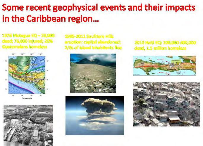
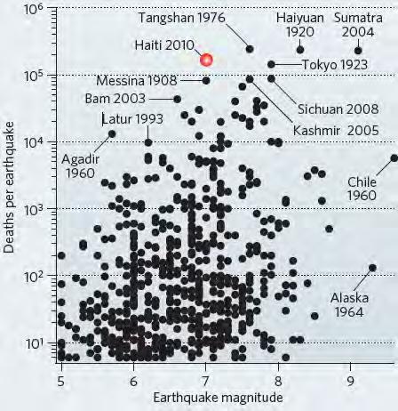
5 RECENT GEOHAZARDS From Bilham, Nature, 2010


6 COCONet SCIENCE: MET & CLIMATE What are the physical mechanisms for the coupling between sea surface temperatures and atmospheric water vapor?


7 COCONet SCIENCE: MET & CLIMATE What is the impact of continuous estimates of PW on hurricane intensity forecasts?

8 COCONet SCIENCE: EARTHQUAKES & ERUPTIONS


9 Previous COCONet meetings COCONet Siting Workshop February 3-4, 2011: Puerto Rico Preliminary Siting Plan Developed: 32 sites prioritized COCONet Operator s Meeting June 28-29, 2011: Trinidad Final Siting Plan Developed: 50 New, 15 Refurbished, and 61+ Existing Stations 3rd COCONet workshop: Tulum, MX last week 80 participants helped to define regional data center requirements
 Existing Stations")
10 2011 Trinidad Siting Plan New Stations (50) Refurbished Stations (15) Existing Stations (61)

11 COCONet: Project baseline
12 COCONet: Construction
13 COCONet Map: Current Installation Status New Stations Planned: 46 Refurbished Planned: 21 New or Refurbished Stations Completed: 28 Stations To Be Completed: 39

14 COCONet Map: Existing Stations Status Existing Stations Planned: 61 (From Trinidad) to 80 Existing Stations Delivering Data to the COCONet Archive: 45 Existing Stations Not Yet Delivering Data to the COCONet Archive: 16-35

15 Proposal accepted by NSF in August, 2012 COCONet Supplement: Tide Gauge stations Construction of 2 premium tide gauge stations - including acoustic and pressure sensors, GPS instruments located on the pier and within 0.5 km of the pier Add GPS at two existing tide gauge instruments in the sea level monitoring network. Work with Tsunami warning and sea level monitoring community to determine where the stations are needed. Photo Courtesy of PRSN


16 COCONet Stations Installed ISCO (CN32): Cocos Island, Costa Rica CN15: Grand Bahama, The Bahamas CN40: Curacao Status: Installed Location: Cocos Island National Park Monument Type: Augured Short Braced Data Communications: Radio link to internet at park offices Partner Organizations: OVSICORI Status: Installed Location: Freeport International Airport Monument Type: Short Drilled Braced Data Communications: Radio link to internet at airport offices Partner Organizations: Bahamas Department of Meteorology Status: Installed Location: Meteorological Department Curacao Headquarters Building Monument Type: Short Drilled Braced Data Communications: Radio link to internet at Me offices Partner Organizations: Meteorological Departmen Curacao


17 COCONet Stations Installed QSEC: Costa Rica VERA: Costa Rica Status: Refurbishment complete Location: Existing monument QSEC Monument Type: Deep Drilled Braced Data Communications: Cellular modem Partner Organizations: OVISCORI Status: Refurbishment complete Location: Existing monument VERA Monument Type: Deep Drilled Braced Data Communications: Cellular modem Partner Organizations: OVISCORI


18 COCONet Science Highlights Mw7.6 Nicoya Earthquake ShakeMap Courtesy of USGS
.")
19 COCONet Science Highlights Hurricane Isaac COCONet stations will improve the forecasts of hurricane track and intensity using continuous observations of integrated water vapor. COCONet stations are equipped with meteorological sensors and the data are analyzed to retrieve precipitable water vapor (PW). The derived PW data are assimilated into the Weather Research and Forecasting (WRF) model to evaluate what impact they have on hurricane forecasts. This movie (courtesy of Braun, et al., UCAR/COSMIC) shows the precipitable water vapor (in mm) along the path of Hurricane Isaac, utilizing some COCONet stations.


20 Difficult Stations Cuba Swan Island Malpelo Island

21 PBO: RT-GPS Upgrade Plan

22 PBO: RT-GPS Upgrade Plan 750+ Real-time stations 10 servers with VMs Efficient load distribution Network Latency: 600 ms Network Completeness: 95% Active Connections 1600 Mount Points Synchronized Databases Redundant Casters Positions and Archiving data Expansion capability to 1000 stations *image is only representative


23 Acknowledgments UNAVCO Staff Barrett Friesen Korey Dausz Emily Seider Jim Normandeau Sara Doelger Brendon Hodge Abe Morrison Max Enders Bob Nolting Adrian Borsa Ken Austin Kyle Bohnenstiehl Taunia Luevano Jaime Magliocca Megan Berg COCONet Partners Principal Investigators Meghan Miller Glen Mattioli Karl Feaux John Braun Eric Calais Bob Wang

24 Thank You For Your Attention!
The Continuously Operation Caribbean Observational Network: COCONet
 The Continuously Operation Caribbean Observational Network: COCONet Glen S. Mattioli University of Texas at Arlington Presenting for COCONet Executive Committee: M. Miller(1), E. Calais(2), C. Meertens(1),
COCONet EAR /9 Quarterly Report
 COCONet FY2012-Q4 Report 1 COCONet EAR 1042906/9 Quarterly Report June 2012 - August 2012 (FY2012-Q4) SUMMARY This quarterly report covers the COCONet project (EAR-1042906/EAR-1042909) activities for the
COCONet EAR /9 Quarterly Report
 COCONet PY2016-Q3 Report 1 COCONet EAR 1042906/9 Quarterly Report March 2016 - May 2016 (PY2016-Q3) SUMMARY This quarterly report covers COCONet project (EAR-1042906/EAR-1042909) activities for the time
USE OF TOTAL COLUMN WATER VAPOR MEASUREMENTS FOR FORECASTS OF THE NORTH AMERICAN MONSOON PRECIPITATION
 USE OF TOTAL COLUMN WATER VAPOR MEASUREMENTS FOR FORECASTS OF THE NORTH AMERICAN MONSOON PRECIPITATION Presented by Yolande Serra University of Arizona Collaborators / Support Ave Arellano (UA Faculty)
COCONet EAR /9 Annual Report
 COCONet EAR 1042906/9 Annual Report September 2013 (FY2013-Q1) - May 2014 (FY2014-Q3) SUMMARY This annual report covers COCONet project (EAR-1042906/EAR-1042909) activities for the time period from September
COCONet EAR /9 Quarterly Report
 COCONet FY2012-Q3 Report 1 COCONet EAR 1042906/9 Quarterly Report March 2012 - May 2012 (FY2012-Q3) SUMMARY This quarterly report covers the COCONet project (EAR-1042906/EAR-1042909) activities for the
COCONet EAR /9 Quarterly Report
 COCONet FY2013-Q4 Report 1 COCONet EAR 1042906/9 Quarterly Report June 2013 - August 2013 (FY2013-Q4) SUMMARY This quarterly report covers COCONet project (EAR-1042906/EAR-1042909) activities for the time
GRUAN GNSS Precipitable Water (GNSS-PW) Task Team: Accomplishment, Progress and Plan
 Task Team: Accomplishment, Progress and Plan") GRUAN GNSS Precipitable Water (GNSS-PW) Task Team: Accomplishment, Progress and Plan Co-chairs: Junhong (June) Wang and Kalev Rannat Members: John Braun, UCAR, USA Galina Dick, GeoForschungsZentrum Potsdam,
GRUAN GNSS Precipitable Water (GNSS-PW) Task Team: Accomplishment, Progress and Plan Co-chairs: Junhong (June) Wang and Kalev Rannat Members: John Braun, UCAR, USA Galina Dick, GeoForschungsZentrum Potsdam,
Strategic Planning of Tuvalu Meteorological Service
 WMO Regional Seminar on Enhancing Service Delivery by National Meteorological & Hydrological Services (NMHSs( NMHSs) ) in RA V Kuala Lumpur, Malaysia, 2 6 April 2007 Strategic Planning of Tuvalu Meteorological
Status of Real Time Broadband Seismic Monitoring in the Caribbean and Adjacent Regions
 Status of Real Time Broadband Seismic Monitoring in the Caribbean and Adjacent Regions Special presentation prepared by Christa G. von Hillebrandt for FDSN meeting, South Africa, 2009 Introductory Remarks
Incorporation of the Caribbean to the Geocentric Reference System for the Americas SIRGAS
 Incorporation of the Caribbean to the Geocentric Reference System for the Americas SIRGAS W. Martínez M. V. Mackern V. Cioce R. Rodino S.R. De Freitas UN-GGIM: Americas Third Session, October 5 2016, Mexico
Annual Report:
 Annual Report: 1042906 Annual Report for Period:09/2011-08/2012 Submitted on: 07/19/2012 Principal Investigator: Miller, M. Meghan. Award ID: 1042906 Organization: UNAVCO, Inc. Submitted By: Miller, M.
IMPACT OF GROUND-BASED GPS PRECIPITABLE WATER VAPOR AND COSMIC GPS REFRACTIVITY PROFILE ON HURRICANE DEAN FORECAST. (a) (b) (c)
 (b) (c)") 9B.3 IMPACT OF GROUND-BASED GPS PRECIPITABLE WATER VAPOR AND COSMIC GPS REFRACTIVITY PROFILE ON HURRICANE DEAN FORECAST Tetsuya Iwabuchi *, J. J. Braun, and T. Van Hove UCAR, Boulder, Colorado 1. INTRODUCTION
9B.3 IMPACT OF GROUND-BASED GPS PRECIPITABLE WATER VAPOR AND COSMIC GPS REFRACTIVITY PROFILE ON HURRICANE DEAN FORECAST Tetsuya Iwabuchi *, J. J. Braun, and T. Van Hove UCAR, Boulder, Colorado 1. INTRODUCTION
Haiti: Earthquake on January 12, 2010
 Geophysical Hazards and Plate Boundary Processes In Central America, Mexico and the Caribbean Haiti: Earthquake on January 12, 2010 Situation, achievements and perspective. Hotel La Condesa, Costa Rica
Strategic Framework on Geospatial Information and Services for Disasters Relevance for the Americas Region
 Strategic Framework on Geospatial Information and Services for Disasters Relevance for the Americas Region Seventh Session of the Committee of Experts on UN-GGIM Side Event --- UN Headquarters, New York
Experiences on Data and Observational Requirements in the Caribbean
 Experiences on Data and Observational Requirements in the Caribbean UNFCCC Expert Workshop on Methods & Tools and on Data & Observations under the NWP on Impacts, Vulnerability & Adaptation to Climate
Curriculum Vitae. Dr. Guoquan Wang
 Curriculum Vitae Dr. Guoquan Wang October 20, 2017 Department of Earth and Atmospheric Sciences University of Houston, Houston, TX 77204 Phone: 713-743-3224; Email: gwang@uh.edu EDUCATION 07/1998 06/2001:
Crisis Support and Disaster Response. in Latin America and the Caribbean
 Crisis Support and Disaster Response in Latin America and the Caribbean The Pan American Agenda 2010-2020 of the Pan American Institute of Geography and History (PAIGH), and the resulting 2010 Implementation
Geodesy. orientation. shape. gravity field
 Geodesy noun Science of measuring the shape, orientation and gravity field of the Earth and how it changes over time. shape orientation gravity field Positioning has always been important Downstream applications
Wireless Networks in Geophysical Monitoring
 Workshop on New Frontiers in Internet of Things 7-18 March 2016 Trieste, Italy Wireless Networks in Geophysical Monitoring Hairo Villalobos Vulcanological and Seismological Observatory of Costa Rica, National
THE PHENOMENON WE CALL A TSUNAMI
 THE PHENOMENON WE CALL A TSUNAMI Dr. Victor Huérfano PUERTO RICO UNIVERSITY MAYAGUEZ CAMPUS GEOLOGY PUERTO RICO SEISMIC NETWORK WHAT IS A TSUNAMI? Global Distribution of Tsunamis 1410 BC AD 2011 NOAA
US Tsunami Services for PR and the VI: An Update from the NOAA NWS Caribbean Tsunami Warning Program
 U.S. National Oceanic and Atmospheric Administration National Weather Service Caribbean Tsunami Warning Program US Tsunami Services for PR and the VI: An Update from the NOAA NWS Caribbean Tsunami Warning
Funded by Japan Government through UN ESCAP and BMKG
 METEOROLOGY & COAST RADIO SERVICES MINISTRY OF METEOROLOGY, ENERGY, INFORMATION,DISASTER MANAGEMENT, ENVIRONMENT, CLIMATE CHANGE AND COMMUNICATION KINGDOM OF TONGA P. O. Box 845, Domestic Terminal, Fua
UN-GGIM:Americas Regional Report
 UN-GGIM:Americas Regional Report 2016-2017 Seventh Session of UN-GGIM 2-4 August 2017, United Nations Headquarters, New York. Rolando Ocampo President of UN-GGIM: Americas Content Activities, Areas of
CLIMATE CHANGE ADAPTATION BY MEANS OF PUBLIC PRIVATE PARTNERSHIP TO ESTABLISH EARLY WARNING SYSTEM
 CLIMATE CHANGE ADAPTATION BY MEANS OF PUBLIC PRIVATE PARTNERSHIP TO ESTABLISH EARLY WARNING SYSTEM By: Dr Mamadou Lamine BAH, National Director Direction Nationale de la Meteorologie (DNM), Guinea President,
Puerto Rico Tsunami Mitigation and Warning Program: Update and Future
 Puerto Rico Tsunami Mitigation and Warning Program: Update and Future Christa G. von Hillebrandt- Andrade, Puerto Rico Seismic Network, UPRM Aurelio Mercado Dept. Marine Sciences, UPRM Status in 1999,
Operational Aspects of GNSS CORS What is a GNSS CORS system used for?
 Please insert a picture (Insert, Picture, from file). Size according to grey field (10 cm x 25.4 cm). Scale picture: highlight, pull corner point Cut picture: highlight, choose the cutting icon from the
Advantages of Regional and Global Data Exchange. Gavin Hayes U.S. Geological Survey, National Earthquake Information Center
 Advantages of Regional and Global Data Exchange Gavin Hayes U.S. Geological Survey, National Earthquake Information Center USGS NEIC Global Earthquake Response Area of responsibility => Global BUT - domestically,
Operational Monsoon Monitoring at NCEP
 Operational Monsoon Monitoring at NCEP Wassila M. Thiaw Climate Prediction Center National Centers for Environmental Predictions Operational Monsoon Monitoring at NCEP Wassila M. Thiaw Climate Prediction
PRELIMINARY AGENDA. President IRIS Consortium Introduction of the Speaker Dr. Olga Cabello
 PRELIMINARY AGENDA Sunday October 24 18:00 Networking Reception 19:30 Dinner 20:30 Welcome and Opening Address Call to order Dr. Olga Cabello Welcome Dr. Marino Protti Opening Remarks Dr. David Simpson
Solid Earth Science... 5 Atmospheric Science... 7 Collateral Benefits Revised COCONet Siting Plan and Future Activities...
 Sponsors The COCONet workshop was supported by NSF-EAR Instrumentation and Facilities Award #1042906. Supplemental contributions were made by NSF-EAR Education & Human Resources, and the Tectonics program;
CHILEAN PART OF SIRGAS REFERENCE FRAME, REALIZATION, ADOPTION, MAINTENANCE AND ACTUAL STATUS. Geodesy for Planet Earth IAG 2009, Buenos Aires
 CHILEAN PART OF SIRGAS REFERENCE FRAME, REALIZATION, ADOPTION, MAINTENANCE AND ACTUAL STATUS Geodesy for Planet Earth IAG 2009, Buenos Aires Ing. Héctor Parra hparra@igm.cl, IGM Chile Dr. Juan Báez jbaez@udec.cl,
Inter-institutional and Intergovernmental Arrangements: MIDAS and the Caribbean Tsunami Warning System
 Inter-institutional and Intergovernmental Arrangements: MIDAS and the Caribbean Tsunami Warning System Christa G. von Hillebrandt-Andrade Manager NOAA NWS Caribbean Tsunami Warning Program Vice Chair UNESCO
GEONETCast Future Plans at CIMH
 GEONETCast Future Plans at CIMH Operations, Training, Climate Monitoring and Disaster Preparedness WORLD METEOROLOGICAL ORGANIZATION COORDINATION GROUP ON SATELLITE DATA REQUIREMENTS FOR REGION III AND
WEATHER AND CLIMATE EXTREMES MONITORING BASED ON SATELLITE OBSERVATION : INDONESIA PERSPECTIVE RIRIS ADRIYANTO
 WEATHER AND CLIMATE EXTREMES MONITORING BASED ON SATELLITE OBSERVATION : INDONESIA PERSPECTIVE RIRIS ADRIYANTO INDONESIA AGENCY FOR METEOROLOGY, CLIMATOLOGY AND GEOPHYSICS (BM KG) 1. INTRODUCTION - BMKG
Alaska Earthquake Center. By Natalia A. Ruppert Seismic Network Manager
 Alaska Earthquake Center By Natalia A. Ruppert Seismic Network Manager Geophysical Institute, University of Alaska Fairbanks Alaska Earthquake Center mission and historical perspective! Regional seismic
ASSOCIATION OF CARIBBEAN STATES (ACS / AEC)
") ASSOCIATION OF CARIBBEAN STATES (ACS / AEC) 1 SHOCS (Strengthening Hydrometorological Operations and Services in Caribbean SIDS) The ACS/Finnish Government response to Hydrometorological risk in Caribbean
ASSOCIATION OF CARIBBEAN STATES (ACS / AEC) 1 SHOCS (Strengthening Hydrometorological Operations and Services in Caribbean SIDS) The ACS/Finnish Government response to Hydrometorological risk in Caribbean
"Outcomes of the storm surge and waves workshop in Dominican Republic and the questionnaire"
 "Outcomes of the storm surge and waves workshop in Dominican Republic and the questionnaire" Strengthening Regional Cooperation to Support Forecasting with Multi Hazard Approach in RA IV Ritz Carlton Grand
JCOMM-CHy Coastal Inundation Forecasting Demonstration Project (CIFDP)
") WMO World Meteorological Organization Working together in weather, climate and water JCOMM-CHy Coastal Inundation Forecasting Demonstration Project (CIFDP) Coastal Flooding & Vulnerable Populations Coastal
WMO World Meteorological Organization Working together in weather, climate and water JCOMM-CHy Coastal Inundation Forecasting Demonstration Project (CIFDP) Coastal Flooding & Vulnerable Populations Coastal
Tsunami detection component: discussion about the existing network and real-time data processing. Begoña Pérez Gómez, Puertos del Estado, Spain
 Tsunami detection component: discussion about the existing network and real-time data processing Begoña Pérez Gómez, Puertos del Estado, Spain Outline Marine network: role within TWS s NEAMTWS overview
Meteorological instruments and observations methods: a key component of the Global Earth Observing System of Systems (GEOSS)
") GLOBAL OBSERVING SYSTEMS Instruments and Methods of Observation Programme Meteorological instruments and observations methods: a key component of the Global Earth Observing System of Systems (GEOSS) Dr.
GLOBAL OBSERVING SYSTEMS Instruments and Methods of Observation Programme Meteorological instruments and observations methods: a key component of the Global Earth Observing System of Systems (GEOSS) Dr.
The ITSU System in the Pacific Region and Future Upgrades
 The ITSU System in the Pacific Region and Future Upgrades Eddie Bernard Director, Pacific Marine Environmental Laboratory (PMEL) NOAA/USA Pacific Tsunami Warning Center OPERATIONAL ACTIVITIES SEISMIC DATA
Report for 15th PCGIAP Meeting at 18th UNRCC-AP Working Group 1 Regional Geodesy
 Report for 15th PCGIAP Meeting at 18th UNRCC-AP Working Group 1 Regional Geodesy Chairman Shigeru Matsuzaka, Japan - shigeru@gsi.go.jp Vice Chairman Prof. Pengfei Cheng, China - chengpf@casm.ac.cn John
EPIC2001 was conceived as an intensive process study along and near 95 o W during September and October 2001 used to make measurements of the atmosphe
 EPIC2001 was conceived as an intensive process study along and near 95 o W during September and October 2001 used to make measurements of the atmosphere and ocean in this region. Two aircraft, the National
National Center for Atmospheric Research Research Applications Laboratory Renewable Energy
 National Center for Atmospheric Research Research Applications Laboratory Renewable Energy Dr. Sue Ellen Haupt, Director & Dr. Branko Kosovic, Program Manager Weather Systems & Assessment Program Research
Weather Data Sharing:
 Weather Data Sharing:. A chance for Foresight HOW CAN CITIZENS BE BETTER PREPARED FOR CHANGES IN THE CLIMATE METEOROLOGICAL SERVICES DEPARTMENT (ZIMBABWE) James Ngoma ECONOMIST WHAT IS COMMON FARMER CITY
Yev Kontar. Illinois State Geological Survey, University of Illinois at Urbana-Champaign
 Addressing Caribbean Geophysical Hazards through the Continuously Operating Caribbean GPS Observational Network (COCONet) and International Ocean Drilling Program (IODP) Yev Kontar Illinois State Geological
MSC Monitoring Renewal Project. CMOS 2012 Montreal, Quebec Thursday, May 31 Martin Elie on behalf of Dave Wartman
 MSC Monitoring Renewal Project CMOS 2012 Montreal, Quebec Thursday, May 31 Martin Elie on behalf of Dave Wartman Presentation Overview Context Monitoring Renewal Components Conclusions Q & A Page 2 Context
GGOS. Global Geodetic Observing System. Carey Noll NASA GSFC (on behalf of GGOS) WDS Forum September 11, 2016
 WDS Forum September 11, 2016") https://ntrs.nasa.gov/search.jsp?r=20160011397 2018-12-07T18:04:29+00:00Z GGOS Global Geodetic Observing System Carey Noll NASA GSFC (on behalf of GGOS) WDS Forum September 11, 2016 Global Geodetic Observing
https://ntrs.nasa.gov/search.jsp?r=20160011397 2018-12-07T18:04:29+00:00Z GGOS Global Geodetic Observing System Carey Noll NASA GSFC (on behalf of GGOS) WDS Forum September 11, 2016 Global Geodetic Observing
Doug Kluck NOAA Kansas City, MO National Center for Environmental Information (NCEI) National Integrated Drought Information System (NIDIS)
 National Integrated Drought Information System (NIDIS)") National Integrated Drought Information System (NIDIS) for the Missouri River Basin Drought Early Warning Information System (DEWS) & Runoff Trends in the Missouri Basin & Latest Flood Outlook Doug Kluck
National Integrated Drought Information System (NIDIS) for the Missouri River Basin Drought Early Warning Information System (DEWS) & Runoff Trends in the Missouri Basin & Latest Flood Outlook Doug Kluck
Seismic and Tsunami Observations of Indonesia
 (Indonesia, Mr. Fatchurochman Iman, 2010-2011S, Mr. Dwi Hartanto/Mr. Tatok Yatimantoro, 2011-2012T) Seismic and Tsunami Observations of Indonesia 1. Seismic Monitoring Agency for Meteorology, Climatology
The Global Geodetic Observing System (GGOS) of the International Association of Geodesy, IAG
 of the International Association of Geodesy, IAG") The Global Geodetic Observing System (GGOS) of the International Association of Geodesy, IAG Hans-Peter Plag (1), Markus Rothacher (2), Richard Gross (3), Srinivas Bettadpur (4) (1) Nevada Bureau of Mines
The Global Geodetic Observing System (GGOS) of the International Association of Geodesy, IAG Hans-Peter Plag (1), Markus Rothacher (2), Richard Gross (3), Srinivas Bettadpur (4) (1) Nevada Bureau of Mines
Tonga Meteorological & Coastal Radio Services
 METEOROLOGY & COAST RADIO SERVICES MINISTRY OF METEOROLOGY, ENERGY, INFORMATION,DISASTER MANAGEMENT, ENVIRONMENT, CLIMATE CHANGE AND COMMUNICATION KINGDOM OF TONGA P. O. Box 845, Domestic Terminal, Fua
Regional Flash Flood Guidance and Early Warning System
 WMO Training for Trainers Workshop on Integrated approach to flash flood and flood risk management 24-28 October 2010 Kathmandu, Nepal Regional Flash Flood Guidance and Early Warning System Dr. W. E. Grabs
What are the social, technical, environmental and economic benefits and opportunities of accessing and sharing geodetic data?
 What are the social, technical, environmental and economic benefits and opportunities of accessing and sharing geodetic data? Graeme Blick Group Manager Positioning and Resilience Land Information New
Network of Direct Broadcast Antenna Systems to Provide Real-Time Infrared and Microwave Sounder Data to NOAA for Numerical Weather Prediction
 Sandy Supplemental Grant Recipient Quarterly Progress Report Network of Direct Broadcast Antenna Systems to Provide Real-Time Infrared and Microwave Sounder Data to NOAA for Numerical Award Number: NA13NES4830007
NOAA Surface Weather Program
 NOAA Surface Weather Program Maintenance Decision Support System Stakeholder Meeting #9 Jim O Sullivan NOAA Surface Weather Program Manager NWS Office of Climate, Water, and Weather Services September
GEORED Project: GNSS Geodesy Network for Geodynamics Research in Colombia, South America. Héctor Mora-Páez
 GEORED Project: GNSS Geodesy Network for Geodynamics Research in Colombia, South America. Héctor Mora-Páez Colombian Geological Survey UNAVCO SCIENCE MEETING Feb 27 March 1, 2012 Boulder, CO, TECTONIC
FOURTH INTERNATIONAL PORT METEOROLOGICAL OFFICERS WORKSHOP AND SUPPORT TO GLOBAL OCEAN OBSERVATIONS USING SHIP LOGISTICS
 FOURTH INTERNATIONAL PORT METEOROLOGICAL OFFICERS WORKSHOP AND SUPPORT TO GLOBAL OCEAN OBSERVATIONS USING SHIP LOGISTICS PMO-IV 8-10 DEC 2010, ORLANDO, FLORIDA, USA 1 This presentation is generally for
Presentation on RSMC Nadi-TCC Activities
 6 th TC RSMC Technical Coordination Meeting, Brisbane, Australia, 2 5 Nov 2009 Presentation on RSMC Nadi-TCC Activities R. Prasad Director RSMC Nadi-TCC NADI TROPICAL CYCLONE CENTRE RSMC NADI - TCC Approved
TEGAM s Connection to the EarthScope Project
 TEGAM s Connection to the EarthScope Project Introduction The EarthScope Project is an undertaking funded by the National Science Foundation in partnership with the United States Geological Survey and
NOAA Hurricane Forecast Improvement Project
 NOAA Hurricane Forecast Improvement Project Fred Toepfer Hurricane Forecast Improvement Project Manager November 9 th, 2009 Outline NOAA Hurricane Forecast Improvement Project Driving Issue Purpose NOAA
Flash flood forecasting and warning infrastructures of National Meteorology and Hydrological Services of Cambodia
 Development and Implementation of the South East Asia Flash Flood Guidance System (SEAFFGS) Ha Noi, Viet Nam, 20-23 November 2017 Flash flood forecasting and warning infrastructures of National Meteorology
GCOS Cooperation Mechanism
 GCOS Cooperation Mechanism GCOS Cooperation Mechanism (GCM) The GCM was established to identify and make the most effective use of resources available for improving climate observing systems in developing
Proper Data Management Responsibilities to Meet the Global Ocean Observing System (GOOS) Requirements
 Requirements") Data Buoy Cooperation Panel XXVI Oban, Scotland, UK 27 September 2010 Proper Data Management Responsibilities to Meet the Global Ocean Observing System (GOOS) Requirements William Burnett Data Management
Data Buoy Cooperation Panel XXVI Oban, Scotland, UK 27 September 2010 Proper Data Management Responsibilities to Meet the Global Ocean Observing System (GOOS) Requirements William Burnett Data Management
Bistandsprosjekter i Sørøst-Asia
 Bistandsprosjekter i Sørøst-Asia -Sikre liv og verdier Lars R. Hole, Hanneke Luijting, Tor Ivar Mathisen og Kristine Gjesdal September 2017 Norwegian Meteorological Institute Background Ministry of Foreign
Agency Vision and Decision- Maker Needs: A USGS Perspective
 Agency Vision and Decision- Maker Needs: A USGS Perspective Connecting Grassroots to Government for Disaster Management David Applegate USGS Associate Director for Natural Hazards September 13, 2012 U.S.
Ensuring the Building of Community Resiliency through Effective Partnership December 4, 2017 Melia Nassau Beach Valentino A. Hanna
 Ensuring the Building of Community Resiliency through Effective Partnership December 4, 2017 Melia Nassau Beach Valentino A. Hanna Sol Caribbean Presence What Occurred Mega Storms 2017 Cat 5 Hurricane
Low-Latency Earthquake Displacement Fields for Tsunami Early Warning and Rapid Response Support
 Low-Latency Earthquake Displacement Fields for Tsunami Early Warning and Rapid Response Support Hans-Peter Plag, Geoffrey Blewitt Nevada Bureau of Mines and Geology and Seismological Laboratory University
Primary author: Tymvios, Filippos (CMS - Cyprus Meteorological Service, Dpt. of Aeronautical Meteorology),
,") Primary author: Tymvios, Filippos (CMS - Cyprus Meteorological Service, Dpt. of Aeronautical Meteorology), ftymvios@ms.moa.gov.cy Co-author: Marios Theophilou (Cyprus Meteorological Service, Climatology
Primary author: Tymvios, Filippos (CMS - Cyprus Meteorological Service, Dpt. of Aeronautical Meteorology), ftymvios@ms.moa.gov.cy Co-author: Marios Theophilou (Cyprus Meteorological Service, Climatology
WMO Public Weather Services: Enhanced Communication Skills for Improved Service Delivery. by S.W. Muchemi (WMO)
") WMO Public Weather Services: Enhanced Communication Skills for Improved Service Delivery by S.W. Muchemi (WMO) Functions of the Public Weather Services (PWS) programme of WMO To strengthen the capabilities
WMO Public Weather Services: Enhanced Communication Skills for Improved Service Delivery by S.W. Muchemi (WMO) Functions of the Public Weather Services (PWS) programme of WMO To strengthen the capabilities
Australia Government Geospatial Capacity Building Efforts in Asia and the Pacific. Dr John Dawson
 Australia Government Geospatial Capacity Building Efforts in Asia and the Pacific Dr John Dawson Presentation Overview About Geoscience Australia Examples of Geospatial Capacity Building Activity Geodesy
Weather Information for Surface Transportation (WIST): Update on Weather Impacts and WIST Progress
: Update on Weather Impacts and WIST Progress") Weather Information for Surface Transportation (WIST): Update on Weather Impacts and WIST Progress Samuel P. Williamson Office of the Federal Coordinator for Meteorological Services and Supporting Research
Weather Information for Surface Transportation (WIST): Update on Weather Impacts and WIST Progress Samuel P. Williamson Office of the Federal Coordinator for Meteorological Services and Supporting Research
Strategic Planning and Management of MMD
 Fifth Technical Conference on Management of Meteorological & Hydrological Services In Regional V (South-West Pacific) Strategic Capacity Development of NMHS s in RAV Malaysia Meteorological Department
COASTAL VULNERABILITY DUE TO SEA-LEVEL RISE HAZARDS IN THE BANGLADESH DELTA: BAND-AID
 Band-Aid Project NASA NASA ESA ESA JAXA NASA/DLR COASTAL VULNERABILITY DUE TO SEA-LEVEL RISE HAZARDS IN THE BANGLADESH DELTA: BAND-AID R. Rietbroek, B. Uebbing, C.K. Shum, V. Ballu, S. Calmant, J. Duan,
Determining and Monitoring Sea Level in the Caribbean using
 Determining and Monitoring Sea Level in the Caribbean using Satellite Altimetry Dexter DAVIS (UWI,Trinidad & Tobago), Michael SUTHERLAND (Canada), Sandesh JAGGAN & Demi SINGH (UWI, Trinidad & Tobago) Overview
the IRIS Consortium Collaborative, Multi-user Facilities for Research and Education Briefing NSF Business Systems Review September 9, 2008
 the IRIS Consortium Collaborative, Multi-user Facilities for Research and Education Briefing NSF Business Systems Review September 9, 2008 A facilities program for collection and distribution of seismological
Japanese Programs on Space and Water Applications
 Japanese Programs on Space and Water Applications Tamotsu IGARASHI Remote Sensing Technology Center of Japan June 2006 COPUOS 2006 Vienna International Centre Water-related hazards/disasters may occur
WMO. Early Warning System
 World Meteorological Organization Working together in weather, climate and water WMO Tropical Cyclone Early Warning System Koji Kuroiwa Tropical Cyclone Programme World Meteorological Organization For
COOP Modernization: NOAA s Environmental Real-time Observation Network in New England, the Southeast and Addressing NIDIS in the West
 COOP Modernization: NOAA s Environmental Real-time Observation Network in New England, the Southeast and Addressing NIDIS in the West Ken Crawford NWS Office of Science and Technology Special Presentation
Wind Tower Deployments and Pressure Sensor Installation on Coastal Houses Preliminary Data Summary _ Sea Grant Project No.
 Wind Tower Deployments and Pressure Sensor Installation on Coastal Houses Preliminary Data Summary _ Sea Grant Project No.:1020040317 Submitted to: South Carolina Sea Grant Consortium 287 Meeting Street
GEO-VIII November Geohazard Supersites and Natural Laboratories Progress Report. Document 9
 GEO-VIII 16-17 November 2011 Geohazard Supersites and Natural Laboratories Progress Report Document 9 This document is submitted to GEO-VIII for information. Geohazard Supersites and Natural Laboratories
EXPLORE PLATE TECTONICS & MORE THROUGH GPS DATA. Shelley Olds, UNAVCO April 12, 2018 NGSS Webinar
 EXPLORE PLATE TECTONICS & MORE THROUGH GPS DATA Shelley Olds, UNAVCO April 12, 2018 NGSS Webinar Today s Outline Central question: How do we know the tectonic plates are still moving? -- What evidence
Faatasi Malologa (PGSC Chair) Director Department of Lands & Survey, Tuvalu
 Director Department of Lands & Survey, Tuvalu") Seventh Session of the United Nations Committee of Experts on Global Geospatial Information Management (UN-GGIM) - 31 July -4 August 2017 Faatasi Malologa (PGSC Chair) Director Department of Lands & Survey,
Seventh Session of the United Nations Committee of Experts on Global Geospatial Information Management (UN-GGIM) - 31 July -4 August 2017 Faatasi Malologa (PGSC Chair) Director Department of Lands & Survey,
Unidata: An Overview. Tom Yoksas. Unidata Program Center / UCAR Boulder, Colorado USA
 Unidata: An Overview Tom Yoksas Unidata Program Center / UCAR Boulder, Colorado USA http://www.unidata.ucar.edu Unidata - Principle Activities Providing Tools to visualize, analyze, organize, receive,
IMS4 ARWIS. Airport Runway Weather Information System. Real-time data, forecasts and early warnings
 Airport Runway Weather Information System Real-time data, forecasts and early warnings Airport Runway Weather Information System FEATURES: Detection and prediction of runway conditions Alarms on hazardous
September 5, 2012 M 7.6 Costa Rica Earthquake
 September 5, 2012 M 7.6 Costa Rica Earthquake On September 5, 2012, a Magnitude 7.6 earthquake occurred in the Nicoya Peninsula of northwestern Costa Rica, along a locked segment of the subduction boundary
Seismogeodesy for rapid earthquake and tsunami characterization
 Seismogeodesy for rapid earthquake and tsunami characterization Yehuda Bock Scripps Orbit and Permanent Array Center Scripps Institution of Oceanography READI & NOAA-NASA Tsunami Early Warning Projects
SAWIDRA Southern Africa
 SAWIDRA Southern Africa Presenter: Thembani Moitlhobogi Assistant Database and IT Expert SADC Climate Services Centre 13 th EUMETSAT Forum in Africa 24-28 September 2018, Abidjan, Cote d Ivoire Context
Using GNSS Signals to Measure Soil Moisture, Vegetation Water Content, Snow Depth, Water Levels, Permafrost, and Volcanic Plumes
 Using GNSS Signals to Measure Soil Moisture, Vegetation Water Content, Snow Depth, Water Levels, Permafrost, and Volcanic Plumes Kristine M. Larson Department of Aerospace Engineering Sciences University
MTO s Road Weather Information System (RWIS)
") MTO s Road Weather Information System (RWIS) Ontario Good Roads Association Managing Winter Operations Workshop October 19, 2017 Overview of MTO s Road Weather Information Station (RWIS) RWIS for Winter
MTO s Road Weather Information System (RWIS) Ontario Good Roads Association Managing Winter Operations Workshop October 19, 2017 Overview of MTO s Road Weather Information Station (RWIS) RWIS for Winter
Climate Services in Practice UK Perspective
 Climate Services in Practice UK Perspective Chris Hewitt ICCS, Columbia University, October 2011 Overview Perspectives on: Why have a climate service? What is a climate service? UK activities Examples
SIRGAS: Basis for Geosciences, Geodata, and Navigation in Latin America
 SIRGAS: Basis for Geosciences, Geodata, and Navigation in Latin America Claudio Brunini President of SIRGAS Universidad Nacional de La Plata, Argentina María Virginia Mackern President of SIRGAS/WG-I:
The National Weather Service of the Future: Building a Weather-Ready Nation
 The of the Future: Building a Weather-Ready Nation Dr. Louis W. Uccellini Director, NOAA Assistant Administrator for Weather Services NCEP Production Suite Review December 2, 2014 Outline Building a Weather-Ready
Eric. W. Harmsen 1, John Mecikalski 2, Pedro Tosado Cruz 1 Ariel Mercado Vargas 1
 Estimating Evapotranspiration using Satellite Remote Sensing in Puerto Rico, Haiti and the Dominican Republic Eric. W. Harmsen 1, John Mecikalski 2, Pedro Tosado Cruz 1 Ariel Mercado Vargas 1 1. University
Himawari-8 BUFR Development for Winds Processing and Radiances Cloud Mask, Cloud Phase, Cloud Height
 Sandy Supplemental Grant Recipient Quarterly Progress Report Himawari-8 BUFR Development for Winds Processing and Radiances Award Number: NA14NES4830006 The National Oceanic and Atmospheric Administration
The Role of Data & Information Infrastructures in Supporting Climate Change Adaptation in Latin America & the Caribbean
 The Role of Data & Information Infrastructures in Supporting Climate Change Adaptation in Latin America & the Caribbean Emil A. Cherrington Senior Scientist Water Center for the Humid Tropics of Latin
13 June Board on Research Data & Information (BRDI)
") Board on Research Data & Information (BRDI) OUTLINE 2 Challenges of Monitoring Climate Change Recruiting Internet Citizen Scientists Partnering with Citizen Science Alliance Project 1: Data Rescue for
Board on Research Data & Information (BRDI) OUTLINE 2 Challenges of Monitoring Climate Change Recruiting Internet Citizen Scientists Partnering with Citizen Science Alliance Project 1: Data Rescue for
Global Challenges - Partnering with Service Providers. World Meteorological Organization. J. Lengoasa WMO Deputy Secretary-General
 WMO World Meteorological Organization Working together in weather, climate and water Global Challenges - Partnering with Service Providers J. Lengoasa WMO Deputy Secretary-General jlengoasa@wmo.int http://www.wmo.int/pages/gfcs/gfcs_en.html
CSRC Director s Report
 CSRC Director s Report C S R C Yehuda Bock Scripps Orbit and Permanent Array Center (SOPAC) California Spatial Reference Center (CSRC) Scripps Institution of Oceanography La Jolla CSRC Coordinating Council