ON THE. Located in the Tahltan Lake Area Liard Mining Division NTS 104G/13E 57' 55' North Latitude 131' 36' West Longitude SUNDIAL RESOURCES LTD.
|
|
|
- Daniela Martin
- 6 years ago
- Views:
Transcription
1 1990 GEOLOGICAL AND GEOCHEMICAL REPORT ON THE RATTLE AND ROLL CLAIMS Located in the Tahltan Lake Area Liard Mining Division NTS 104G/13E 57' 55' North Latitude 131' 36' West Longitude GEOLOGICAL BRANCH ASSESSIMENT PV*n1'T SUNDIAL RESOURCES LTD. -prepared by- Bruno Kasper, Geologist February, 1991 Equity Engineering Ltd. -
2 1990 GEOLOGICAL AND GEOCHEMICAL REPORT ON THE RATTLE 2WD ROLL CLAIMS TABLE OF CONTENTS INTRODUCTION LIST OF CLAIMS LOCATION, ACCESS AND PHYSIOGRAPHY PROPERTY MINING HISTORY 4.1 Previous Work Work Program REGIONAL GEOLOGY PROPERTY GEOLOGY AND MINERALIZATION 6.1 Property Geology 6.2 Mineralization GEOCHEMISTRY DISCUSSION AND CONCLUSIONS Pase.l..l..2. APPENDICES Appendix A Appendix B Appendix C Appendix D Appendix E Bibliography Statement of Expenditures Rock Descriptions Certificates of Analysis Statement of Qualifications LIST OF FIGURES Figure 1 Figure 2 Figure 3 Figure 4 Figure 5 Location Map Claim Map Regional Geology Geology and Geochemistry -- Rattle and Roll claims Geology and Geochemistry -- Rattle 6 and Roll 2 claims Following Pase.l LIST OF TABLES Table Table Pase Claim Data.l. correlation of Lithological Units.7. Equity Engineering Ltd.
3 1.0 INTRODUCTION The Rattle and Roll claims, consisting of the Rattle 1-6 and Roll 1-6 claims, were staked in March 1989 and October 1990 to cover favourable geology, geochemistry and geophysics north of the tik kine ~iver, approximately 29 kilometres west of Telegraph Creek in northwestern British Columbia (Figure 1). Initial prospecting and mapping in 1989 resulted in the discovery of several coppergold showings. The geological similarity to the Galore Creek, Iskut River, Sulphurets and Stewart mining camps to the south and the area's potential for precious metal mineralization have sparked renewed exploration interest throughout the area. Property-wide geological mapping, prospecting and geochemical sampling, was carried out over the Rattle and Roll property in September and October of Equity Engineering Ltd. conducted this program for Sundial Resources Ltd. and has been retained to report on the results of the fieldwork. 2.0 LIST OF CLAIMS Records of the British Columbia Ministry of Energy, Mines and Petroleum Resources indicate that the following claims (Figure 2), situtated in the Liard Mining Division, are owned by Pass Lake Resources Ltd.. Separate documents indicate that the claims are held in trust for a joint venture of Pass Lake Resources Ltd. (50%) and Golden ~itka Resources Inc. (50%). Other documents indicate that the property is currently held under option by Sundial Resources Ltd.. Claim data for the Rattle and Roll property is summarized in Table TABLE CLAIM DATA Claim Record No. of Record Expiry Name Number Units Date Year Roll 1 Roll 2 Roll 3 Roll 4 Roll 5 Roll 6 Rattle 1 Rattle 2 Rattle 3 Rattle 4 Rattle 5 Rattle 6 March 21, March 21, March 21, March 21, March 22, March 22, March 25, March 25, March 25, March 25, March 25, October 1, Equity Engineering Ltd.
4 PROPERTY LOCATION Km Km 1 * L : : MILES D MILES 1 1 I SUNDIAL RESOURCES LTD. 1 I RATTLE 8 ROLL PROJECT I DRAWN J.JE. LOCATION MAP BRl TI SH COLUMBIA I I
5 The Rattle 6 claim was staked in October 1990 to cover a 400 metre fraction between the Rattle 3 and Roll 2 claims, a 40 metre fraction between the Rattle 5 and Roll 1 and 2 claims and a 50 metre fraction between the Rattle 3 and Rattle 5 claims. The Rattle 5 claim overlaps previously staked ground of the Canyon 1-20 claim to the northwest, reducing the actual ground coverage of the claim groups to approximately 216 units. The positions of all legal corner posts for the Rattle and Roll claims have been verified in the field by the author. 3.0 LOCATION, ACCESS AND PHYSIOGRAPHY The Rattle and Roll claims are located within the Boundary Ranges of the Coast Mountains approximately 29 kilometres west of Telegraph Creek in northwestern British Columbia (Figure 1). These claims lie within the Liard Mining Division, centred at 57' 55, north latitude and 131' 36' west longitude. Access to the Rattle and Roll property during the 1990 exploration program was provided by daily helicopter setouts from the Ball Ranch, which is located approximately 20 kilometres to the southeast on Callbreath Creek. The Ball Ranch is connected by road and ferry to Glenora, which is located sixteen kilometres southwest of Telegraph Creek along a secondary gravel road. In the 19601s, Stikine Iron Mines Ltd. constructed a cat road from Glenora up Shakes Creek to their MH property. This road, which has been upgraded for four-wheel drive vehicles up to Kink Creek, terminates four kilometres to the west-southwest of the Roll 5 claim. The Rattle and Roll property covers the rolling plateau which extends south from Tahltan Lake to Shakes Creek and east towards Shakes Lake. The Rattle 1-6 claims cover the moderate topography between Tahltan and Shakes Lakes including a low lying mountain (termed ItEast Mountaint8 in this report) north of Shakes Lake. The Roll 1-6 claims straddle a plateau (termed "Roll Plateau8@) that separates Tahltan Lake from Shakes Creek. Topography ranges from gentle in the subalpine meadows of the Roll Plateau to rugged along the plateau's edges. Elevations range from 812 metres on Tahltan Lake, to over 1,500 metres on Roll Plateau. Approximately seven units of the Rattle 1 and 5 claims overlie Tahltan and South Tahltan Lakes. The property below the level of the Roll Plateau is covered by a dense growth of conifers with an undergrowth of devil's club and huckleberry. Flat lying areas tend to be swampy and may contain a dense growth of alders and black spruce, while steeper open slopes are covered by dense slide alder growth. Above tree line, which occurs between l,l3o and 1,400 metres, more open alpine Equity Engineering Ltd. -
6 SUNDIAL RESOURCES LTD. I 0 I 2 3 k I I I. KILOMETRES RATTLE 81 ROLL PROJECT CLAIM MAP BRITISH COLUMBIA EQUITY ENGINEERING LTD. MINING DIV.: LlARD q.t.s.: 104G/ 13 E SCALE: 1:50000 )ATE: DEC REVISED: FIGURE
7 vegetation is present. The Rattle and Roll claims lie in an intermediate or gradational belt between the wet belt of the Coast Range and the dry belt of the Stikine Plateau. The summers are typically cool and showery with occasional snowfalls. Accumulated snow in the winter is considerably less than in the wet belt. Prospecting could be started in July and continued through till October in a normal year. Shaded creek beds commonly contain packed snow until mid to late July. 4.0 PROPERTY MINING HISTORY 4.1 Previous Work Placer gold was discovered on gravel bars of the Stikine River between Glenora and Telegraph Creek in 1861 and worked extensively until the early 1900's. The placer gold deposits of the lower Barrington River have been worked sporadically since The area south and west of Telegraph Creek was extensively explored for its copper potential throughout the 1960'~~ following the discovery of the Galore Creek copper-gold porphyry deposit in 1955 and the Schaft Creek copper-molybdenum deposit in 1957, both of which host greater than one million tonnes of contained copper. These deposits are located 85 kilometres south-southwest and 60 kilometres south, respectively, from Telegraph Creek. Several copper occurrences were discovered southwest of Telegraph Creek at this time (Figure 3). Kennco explored copper mineralization within a syenitic border phase of a large granodiorite stock and its intruded volcanics on their Poke claims, on Limpoke Creek. Their Gordon claims, located at the junction of Limpoke Creek and the Barrington River, also host disseminated copper mineralization within the syenitic phase of the stock and the intruded volcanics (BCDM, 1966). The MH iron deposit, hosted by a pyroxenite stock on Shakes Creek approximately four kilometres west of the Roll 5 claim, was also explored extensively in the 1960's. Amax Explorations Inc. staked the VB claims in 1973 to cover a copper-iron skarn west of Tahltan Lake on the current Canyon 1-20 claim (Hodgson and LeBel, 1974) (Figure 3). The skarn mineralization consists of chalcopyrite, pyrite, pyrrhotite, magnetite and specular hematite adjacent to a diorite stock (BCDM, 1974). In 1974, a soil geochemical grid was established and a magnetometer survey was conducted with magnetic highs coinciding with known mineralized skarn areas. With increased gold exploration during the late 1970's and early 1980fs, most of the copper prospects were re-evaluated for -. Equity Engineering Ltd. -
8 their gold potential. Du Pont of Canada Exploration Ltd. conducted geological, geochemical and geophysical surveys over Mount Barrington, sixteen kilometres southwest of the Rattle and Roll claims, following up highly anomalous gold geochemistry from fieldsieved stream sediment samples collected during a regional survey. Korenic (1982) reported assays up to g/tonne (3.575 oz/ton) gold from narrow pods of massive pyrite, arsenopyrite, chalcopyrite and pyrrhotite. In 1987, the federal and provincial geological surveys conducted a joint regional silt sampling program over the entire Telegraph Creek and Sumdum map sheets, taking a total of 1,291 samples (GSC, 1988). Six silt samples were taken from creeks draining the Rattle and Roll claims, one of which exceeded the 90th percentile in gold. In 1989, Pass Lake Resources Ltd. and Golden Sitka Resources Inc. carried out geological mapping, prospecting and silt sampling on the Rattle and Roll property, taking 27 stream sediment samples and 64 rock samples. Quartz-sulphide veinlets within volcanics assayed 8.37 g/tonne (0.244 oz/ton) gold in a float sample taken from the Rattle 3 claim while a grab sample from a narrow shear structure in the west bank of West Middle Creek on the Roll 2 claim assayed 3.09 g/tonne (0.090 oz/ton) gold. A tributary of North Creek on the Rattle 2 claim was anomalous in gold, copper and arsenic, with 65 ppb, 104 ppm and 135 ppm, respectively -(~as~er, 1990) Work Program During September and October of 1990, Sundial Resources Ltd. carried out property-wide exploration on the Rattle and Roll claims, consisting of further geological mapping, prospecting, silt sampling and soil sampling. This program was targeted at gold-rich mesothermal base metal veins similar to those situated within a similar geological environment which stretches south through the Galore Creek, Iskut River, Sulphurets and Stewart mining districts. During the course of this program, 60 silt samples, 32 soil samples and 128 rock samples were taken. Silt samples were taken from backwaters or dry beds of drainages, sieved to minus 80 mesh in the laboratory and analyzed geochemically for gold and 32 elements by ICP. Samples with insufficient fines were screened through a minus 35 mesh and then pulverized to minus 150 mesh before being analyzed (Figures 4 and 5). A line of contour soil samples were taken at the 1,280 metre elevation on the east bank of East Middle Creek (CL1280 in Figure 5). Wherever possible, soil samples were taken from the red-brown B horizon. Where soil development was poor, talus fines were taken. Soil samples were analyzed geochemically for gold and 32 elements by ICP. Equity Engineering Ltd. -
9 Geological mapping and prospecting were carried out over the entire property using a 1:10,OOO enlargement of the 1:50,000 government topographic map as a base (Figure 4). Rock samples, described in Appendix C, were taken from zones of alteration and mineralization and analyzed geochemically for gold and 32 elements by ICP. Samples exceeding 1,000 ppb gold or 10,000 ppm for base metals, were assayed for the appropriate elements. Analytical certificates are attached in Appendix D. 5.0 REGIONAL GEOLOGY The Telegraph Creek area lies on the western margin of the Intermontane Belt within the Stikine Arch near its contact with the Coast Plutonic Complex (Figure 3). A sequence of Palaeozoic to Middle Triassic oceanic sediments is unconformably overlain by Upper Triassic island arc volcanics and sediments equivalent to ~tuhini Group rocks. These have been intruded by Upper Triassic to Lower Jurassic syenitic stocks and by Jurassic to Lower Cretaceous quartz diorite and granodiorite plutons of the Coast Plutonic Complex. The oldest rock assemblage in the Telegraph Creek area consists of Permian bioclastic limestone (Unit 3) overlying metamorphosed sediments and volcanics (unit 2) and crinoidal limestone (Unit 1). Unconformably overlying the Permian limestone unit are Upper Triassic rocks (Units 5 through 8) equivalent to the Stuhini Group island arc volcanics and sediments. In the Telegraph Creek area, Souther (1971) grouped these volcanic and sedimentary members in Unit 9, noting however, that it was composed predominantly of augite andesite breccia, conglomerate and volcanic sandstone. Several significant gold occurrences are hosted by Upper Triassic Stuhini volcanics in a cluster around Galore Creek, seventy kilometres to the south. Small, equidimensional syenite, pyroxenite and orthoclase porphyry stocks (Unit 12), dated as Late Triassic to Early Jurassic by Souther (1971), intrude mainly Stuhini volcanics. The Galore Creek and Copper Canyon copper-gold porphyry deposits are hosted by Upper Triassic volcanics intruded by syenitic stocks of Unit 12. Orthoclase porphyry or syenite stocks are associated with most significant precious metals deposits in the Stewart, Sulphurets and Iskut River districts, including the ~ilbak Premier, Sulphurets, and Snip deposits. Lower Jurassic conglomerates (Unit 13) with granodiorite clasts unconformably overly Stuhini Group equivalent Triassic sediments. The Jurassic volcano-sedimentary strata are similar in appearance to those of the underlying Stuhini Group, with differentiation possible mainly through fossil identification. To Equity Engineering Ltd.

10 l LEGEND - rmrrm GROUP - M,m,-(o -. phk blotl--d "-&I. C d Z a m n u. ete-hddrr c-dm-. - a LfL rulma. -.,.-. s"-a-.byi d rm- e 4 b.lomor.u. mlrmlruc rn... srsls: m.du-m~.dlr ;~~N.omrr.U. n -II....I,UM: *.a0 M...IO.,"C "_L.dO mu. -r,c. i.,la+,on. vad.,,".,.o.",n,oluuc r-.. I SUNDIAL RESOURCES LTD. I I RATTLE 8 ROLL CLAIMS - REGIONAL GEOLOGY SCALE 1: 250,000 MILES LlARD MINING DIVISION, B.C I I EQUITY ENGINEERING LTD. DRAWN. N.T.S. DATE FIG NO. KILOMETRES.I W 104G/13 DEC
11 the southwest, these Jurassic rocks have been assigned to the Hazelton Group by Brown and Greig (1990). Jurassic and/or Cretaceous granodiorite to quartz diorite batholiths (Unit 17) of the Coast Plutonic Complex intrude all older lithologies. This complex consists mainly of medium-grained hornblende-biotite granodiorite with lesser hornblende quartz diorite and is locally foliated near its margins. Marginal phases of this intrusive unit have been noted by government geologists to range from syenitic to dioritic, and they conclude ffmuch additional work is needed to subdivide the many phases of this map-unit" (Souther, 1971). One of these marginal phase plutons outcrops between Tahltan and South Tahltan Lakes. This dioritic pluton (Unit 18) consists of medium- to fine-grained, equigranular hornblende diorite with accessory biotite and magnetite. Coarse conglomerate, sandstone, siltstone and minor black shale of the Upper Cretaceous and Lower Tertiary Sustut Group (Unit 21) unconformably overlies Jurassic strata on Mount Helveker and are found along the Stikine River below Telegraph Creek. Conformably overlying the Sustut Group on Helveker Mountain are about 160 metres of felsic to intermediate, mainly pyroclastic rocks (Unit 24), correlated by Souther (1971) to the Early Tertiary Sloko Group found further to the northwest. Upper Tertiary and Quaternary basalt flows (Unit 25) are exposed in the Stikine River and north of Dodjatin Mountain. 6.0 PROPERTY GEOLOGY AND MINERALIZATION 6.1 Property Geology The geology of the Rattle and Roll property (Figures 4 and 5) is dominated by Upper Triassic volcanics, pyroclastics and sedimentary rocks (Unit 8). These stratigraphic units are believed to belong to the Upper Triassic Stuhini Group because of the augite-rich nature of the volcanic rocks, which is characteristic of the Stuhini Group (Brown and Greig, 1990). Jurassic to Tertiary plugs and dykes intrude the Upper Triassic strata and range in composition from mafic (gabbroic) to felsic (monzonitic). Greenschist facies metamorphism, consisting of weak chlorite, calcite and epidote alteration, is pervasive throughout the Upper Triassic rocks, but is overprinted by moderate to intense ironcarbonate+quartz alteration believed to be associated with localized- faulting. Faults offsetting all rock units are highlighted by drainage patterns and gullies in the area. The property geology in Figures 4 and 5 is a compilation of geological mapping completed during the 1990 and 1989 programs, as well as mapping on the adjoining Canyon 1-20 claim by Homestake geologists in 1989 (Marud, 1989). Table correlates the lithological units used in Figures 4 and 5 of this report, with those of I Equity Engineering Lid. -
12 Souther's (1971) described in the previous Regional Geology section (Section 5.0). TABLE CORRELATION OF LITHOLOGICAL UNITS Map Unit Lithological Unit Map Unit (this re~ort) (Souther) Upper Triassic: 8 undifferentiated strata: 8A sedimentary fine-grained siliciclastics: 8B sedimentary conglomerate: 8C micritic limestone: 8D augite porphyry: 8E andesite (plagioclase porphyry): 8G crystal tuff and tuffaceous sediments: 8H - lapilli tuffs and agglomerates: Early to Middle Jurassic 11A syenite, orthoclase porphyry: 11B - monzonite: Jurassic and/or Cretaceous 12B - hornblende diorite, minor pyroxenite and gabbro : 12E - granodiorite, quartz diorite: Tertiary and Older 14G - felsic dykes or sills Although outcrops of all units are found throughout the property, Upper Triassic sedimentary rocks underlie the majority of the property north of the Roll Plateau while volcanic and pyroclastic lithologies are the dominant units on the plateau. Fine-grained siliciclastics consisting of interbedded wacke, siltstone, cherty siltstones and argillites (Unit 8A) form the bulk of the sedimentary rocks. These rocks, which underlie the majority of the Rattle claims, are generally thinly bedded and dip moderately to steeply to the north. Along South Tahltan Lake and on the north slope of Roll Plateau, cherts and siliceous siltstones become more prevalent. On the east side of Tahltan Lake, this unit overlies the micritic limestone of Unit 8C, while along the north slope of the Roll Plateau, minor mafic volcanic flows of Unit 8D and crystal ash tuffs of Unit 8G are interbedded with the sedimentary rocks. Limited outcrops of massive argillite along North Creek and along its eastern tributary, indicate that the north flank of East Mountain is underlain by fine-grained siliciclastics. In the southern part of the Roll 5 claim, thinlybedded wackes and argillites containing bivalve moulds outcrop along West Short Creek and are bounded to the north by an inferred east-west trending fault. 7 Equity Engineering Ltd. -

13 Thick beds of pebble to cobble conglomerate (Unit 8B) are interbedded within thinly-bedded siltstone and argillite 250 metres southwest of the Rattle 1 to 4 common legal corner post (Figure 4). These beds strike east-west and dip steeply to the south, with the tops of fining-upwards sequences facing south. Small outcrops of unsorted conglomerate occur 100 metres to the east, but no bedding indicators were observed within them. Impure grey, micritic limestone (Unit 8C) form prominent knolls at the south end of Tahltan Lake. The partially recrystallized limestone is locally argillaceous and interbeds of calcareous wacke and lithic lapilli tuffs have been mapped along the north shore of South Tahltan Lake. Bedding within this unit is generally thick (>I. 0 metre), but very faded laminations possibly representing relic bedding have been observed in outcrop near the Rattle 5 legal corner post. The unit is moderately fractured throughout with resistant calcite-filled brecciated layers and veinlets standing out on the weathered surfaces. Upper Triassic (?) bivalve moulds have been found in an outcrop on the north shore of South Tahltan Lake. The volcanic rocks on the Rattle and Roll property have been subdivided into two main units based on the dominant phenocryst present: augite porphyry and andesitic (plagioclase porphyry) flows. Augite porphyry flows (Unit 8D), are characterized by two to four millimetre, black, prismatic augite phenocrysts within a dark green to black aphanitic matrix. Minor amounts of smaller plagioclase phenocrysts may be present. In places, the augite phenocrysts measure up to 30 millimetres in length within a coarser-grained matrix and may represent feeder sills or dykes for the flows. A flow unit overlies the sedimentary rocks of Unit 8A within the Rattle 1 claim and a separate flow is overlain by the sedimentary rocks along the north slope of the Roll Plateau. Widespread areas of augite-porphyry flows are also found on the Roll Plateau within the lapilli tuffs and agglomerates of Unit 8H. Massive andesitic flows form small, distinct outcrops throughout the property and are generally found interlayered with the pyroclastics of Unit 8H. The andesites differ from the augite porphyries by the abundance of plagioclase and lack of augite phenocrysts. A distinctive subunit of these flows is a plagioclase porphyry which has a characteristic trachytic texture (Unit 8E1) and forms reddish weathering outcrops on the south side of South Tahltan Lake and on a small knoll on the west side of West Middle Creek. These plagioclase porphyry flows are characterised by parallel to subparallel plagioclase phenocrysts up to 6 millimetres in length which form up to 40% of the rock, within a black, aphanitic matrix. The reddish weathering of some of the outcrops allows it to be mistaken for a syenite porphyry, but the lack of any potassium feldspar is evident upon staining. A finer-grained variety of andesite outcrops throughout the Roll Plateau. This andesite lacks the trachytic texture of the flows found around Equity Engineering Ltd. -
 and lapilli tuffs and agglomerates (Unit 8H).")
14 south Tahltan Lake, but still contains abundant plagioclase phenocrysts. The pyroclastic rocks found on the property have been divided into two units: crystal ash tuffs and tuffaceous sediments (Unit 8G) and lapilli tuffs and agglomerates (Unit 8H). The thinly bedded crystal ash tuffs and tuffaceous sediments of Unit 8G are interbedded along with minor augite-porphyry flows within the sedimentary rocks of Unit 8A along the north side of Roll Plateau. On the Rattle 1 and 4 claims, this unit appears to cover an extensive area, but may be part of the lapilli tuffs or finegrained siliciclastics that border them. The crystal ash tuffs are easily mistaken for volcanic wacke due totheir fine-grained nature but can be recognized by the presence of highly angular crystal detritus. The lapilli tuffs and agglomerates of Unit 8H are the dominant lithological unit on the Roll Plateau. These pyroclastics contain angular to subrounded volcanic clasts similar in composition to the volcanic flows described earlier, within a matrix of fine-grained crystal detritus. The outcrops are usually unbedded and visible contacts with the volcanic flows are rare. This unit overlies the sedimentary and volcanic rocks found on the north side of the Roll Plateau and appears to be part of a thick volcanic package on the Rattle 1 and 2 claims. Orthoclase porphyry plugs (Unit 11A) and monzonite dykes (Unit 11B) of assumed Early to Middle Jurassic age intrude the Upper Triassic stratigraphy. The orthoclase porphyries intrude volcanic flows west of West Middle Creek, while the monzonite dykes outcrop along the flanks of Roll Plateau. The porphyries contain white to pink, tabular, orthoclase megacrysts up to seven centimetres in length within a pinkish-green, fine- to medium-grained matrix. The monzonite dykes are fine-grained, pinkish-grey and are generally magnetic, varying in width from eight to ten metres. Diorite and gabbro stocks and dykes (Unit 12B) of Jurassic and/or Cretaceous age (?) are believed to be part of a marginal phase of the Coast Plutonic Complex (Souther, 1971). A mediumgrained, equigranular diorite stock intrudes the sedimentary rocks at the south end of Tahltan Lake. Similar, but smaller intrusives were also mapped last year along the eastern edge of the Roll Plateau. Bluish-grey to black, fine- to medium-grained gabbros were located last year west of West Middle Creek. These gabbros could be part of the feeder system for the augite-porphyry flows, indicating an Upper Triassic rather than a Jurassic age for them. Tertiary or older felsic dykes or sills (Unit 14G) are poorly exposed in subcrop near the southern claim boundary on the Rattle 4 claim (Figure 4) and along the eastern claim boundary of the Roll 2 claim (Figure 5). These light, greenish-grey intrusives are fine-grained and contain clots of chlorite. I Equity Engineering Ltd.
15 Glacial striations found on the Roll Plateau indicates that the glaciers advanced to the north-northeast. Large portions of the Roll Plateau as well as the Rattle claims are covered in glacial till of variable thickness whose impact on geochemical sampling cannot be ignored. At least three different fault trends have been recognized through mapping and air photo interpretation for the Rattle and Roll property. The most prominent of these structures is a northeast to southwest trending fault which bounds the limestone exposed south of Tahltan Lake along its southern border. A similar fault crosscuts the sedimentary rocks on the Roll Plateau at the headwaters of East Middle Creek. his set of faults appear to offset the two other two sets which are oriented generally northsouth and east-west. Faults trending in a north-south and east-west direction outcrop in and between the three main streams draining the north side of the Roll Plateau. Moderate to intense brecciation and iron-carbonate or clay alteration zones are commonly associated with these faults. Most of the gold-bearing shears and veins described in the following section are found within the ironcarbonate alteration zones that highlight these structures. An aeromagnetic high is centred over the Roll 3 to 6 claims (GSC, 1978). Mapping within the area suggests that the magnetic high was the result of a thicker sequence of augite-porphyry flows which are weakly magnetic. This is supported by magnetic lows over areas that have a thicker sedimentary package such as East Mountain and the north slope of the Roll Plateau. 6.2 Mineralization Several precious and base metal occurrences were discovered in 1989 and 1990 along the northern edge of the Roll Plateau. The mineralization occurs within a broad area underlain by Upper Triassic sedimentary and minor volcanic rocks that have been moderately to intensely carbonate altered. Of these new occurrences within this area, the Frosty Showing is the most significant. The Frosty Showing consists of a number of easterly trending, chloritic shear zones exposed for 200 metres along the banks of West Middle Creek at approximately the 1,200 metre elevation (Figure 5). The shear zones vary in width from 0.3 to 1.5 metres, strike between 050' and 085', dipping steeply to the north or south and are exposed in outcrop on either side of the creek for up to five metres. While disseminated pyrite is common throughout these structures, the gold-bearing occurrences contain up to 5% chalcopyrite in blebs associated with small, localized chalcedony veinlets. Channel sample , taken across a 30 centimetre shear zone, assayed 1.54 g/tonne (0.045 oz/ton) gold with 9.6 ppm I Equity Engineering Ltd.
. Lead, zinc and arsenic values are generally low with localized enrichment up to 30 pprn lead, 200 pprn zinc and 435 pprn arsenic.")
16 silver and 1.79% copper. Channel sampling across a gold-bearing shear zone found last year (sample ) returned 2.54 g/tonne (0.074 oz/ton) gold along with 2.0 pprn silver and 1,405 pprn copper over 1.5 metres (sample ). Lead, zinc and arsenic values are generally low with localized enrichment up to 30 pprn lead, 200 pprn zinc and 435 pprn arsenic. Auriferous calcite vein float was found within or near intensely iron-carbonate altered areas 450 metres to the southeast (sample ) and 400 metres north (sample ) of the Frosty Showing. Float sample , which assayed 2.74 g/tonne (0.080 oz/ton) gold with negligible silver and base metal values, was taken from a ten centimetre wide calcite vein containing pyrite stringers within frost-heaved boulders. Grab samples from calcite veining 75 metres to the east as well as samples taken of the ironcarbonate alteration halo, were only slightly enriched in gold, up to 255 ppb (sample ). Float sample , found at the 1,030 metre elevation within West Middle Creek, assayed 1.65 g/tonne (0.048 oz/ton) gold along with 59.4 pprn silver and 1.34% copper. The sample was taken of the copper-oxidized rind on a piece of calcite vein float. Although the source of this boulder was not located, grab sample , taken from a 50 centimetre carbonate vein outcropping 100 metres upstream, was enriched in silver (24.8 ppm) and copper (1,650 ppm), but low in gold (50 ppb). Similar float material (sample ) located 100 metres upslope to the west, was also enriched in gold (470 ppb) and copper (895 pprn). Other calcite and/or carbonate veins sampled last year in this area contained low amounts of gold, silver and copper. None of the samples found within the area of float sample contained tetrahedrite, which occurs within quartz veining 100 metres downstream. An attempt was made to locate the source of the gold-bearing quartz veinlet float found last year in the northeast corner of the Roll Plateau (Figure 5). Float sample assayed 8.37 g/tonne (0.244 oz/ton) gold. Although the source of sample was not found this year, similar quartz veinlets located 450 metres to the northwest returned 1.78 g/tonne (0.052 oz/ton) gold (sample , Figure 4). This sample was a select grab from a series of 2.5 centimetre wide, discontinuous quartz-carbonate veinlets which contained 1% pyrite. These veinlets parallel an easterly trending fault in the immediate area. Numerous samples were taken of the iron-carbonate altered gossanous outcrops formed along mapped and inferred faults. The distinct reddish-orange colour is characteristic of these gossans. Except for the gold-bearing shear structures or veining within these altered zones described above, all samples returned low precious and base metal values. Skarn occurrences found within the Upper Triassic limestone Equity Engineering Ltd. -
17 and related to the Jurassic and/or Cretaceous intrusives, host known copper-iron mineralization on the Canyon 1-20 claim approximately 400 infi file occurrence 083) and 1,400 metres (Minfile occurrences 081 and 082) north of the Rattle 5 claim. No similar skarns or mineralization were found near or along the limestone-diorite contact on the Rattle 5 claim. 7.0 GEOCHEMISTRY During the course of the 1990 field season, 60 silt samples and 32 soil samples were collected. Geochemical data from the stream sediment samples were compared with the statistical data for the government silt sampling survey of the Telegraph Creek - Sumdum map sheet (GSC, 1988). The silt samples are directly comparable to the government results listed in Figures 4 and 5, and anomalous results can be defined in the same way. There were not enough soil samples taken to conduct a meaningful statistical analysis but is felt that the following levels are anomalous: gold (25 ppb), silver (1.0 pprn), copper (100 pprn), lead (20 pprn), zinc (150 ppm) and arsenic (20 pprn). Two of the silt samples, 90RG-14 and 90MO-46, exceeded or were equivalent to the governments 90th percentile in gold (30 ppb). Silt sample 90MO-46 (Figure 4), which contained 55 ppb gold, was taken from a dry stream bed at the headwaters of Middle East Creek at the northern end of the Roll 4 claim. This sample was also weakly anomalous in zinc (156 pprn). Rock samples collected from this area contained undetectable levels of gold, while float sample , found 250 metres to the west, was enriched in zinc (1,185 ppm). Silt sample 90RG-14 (Figure 5), which contained 30 ppb gold along with anomalous copper (135 ppm) and zinc (202 pprn), was collected from a tributary of East Middle Creek which drains a pond at the northern end of the Roll 2 claim. Two rock samples taken from a siliceous and pyritic zone 65 metres upstream of the silt sample returned up to 385 ppb gold (sample ), but were low in copper and zinc (up to 347 and 122 ppm, respectively). Further reconnaissance work was also conducted along North Creek and its western tributary from which a stream sediment anomalous in gold, copper and arsenic from the government regional survey (silt sample ) and duplicated last year (silt sample TB-8). Silt samples taken further upstream along North Creek and its eastern tributaries failed to duplicate these results and generally contained low levels of gold, copper and arsenic. Rock samples taken along these creeks returned low levels of precious and base metal values, although grab samples to collected near the northwest corner of the Rattle 2 claim in 1989, were enriched in arsenic. These samples were taken from clay and carbonate altered outcrops located along a major northeasterly trending fault. Equity Engineering Ltd. -
18 Anomalous values of copper, arsenic and zinc were recovered from a number of streams draining areas of inferred faults. These samples include silt samples 90BK-14 to 90BK-16 fromthree adjacent small streams on the Rattle 5 claim and silt samples 90MO-36 and 90MO-37, collected from a small creek on the Roll 1 claim. The creek from which samples 90MO-36 and 90MO-37 were taken, lies 370 metres to the west of West Middle Creek and drains an east-west trending fault along with the probable western extension of the Frosty Showings. Anomalous zinc values were returned for 27 of the 60 silt samples taken during the 1990 field program. These anomalous values may be related to high background values of zinc within the volcanic and sedimentary rocks as no significant zinc mineralization has been found to date on the property. Contour soil line CL1280 (Figure 5) was established along the 1,280 metre elevation to determine the precious metal potential of the iron-carbonate alteration zone exposed in East Middle Creek and to detect the presence of any auriferous shear structures similar to those found in West Middle Creek. The soil line was anomalous in copper and arsenic over most of its length with highs up to 415 ppm copper and 120 ppm arsenic. Stations O+OOE to 0+50E were anomalous in gold, returning values of 60, 50 and 75 ppb, respectively, along with anomalous zinc. Station 2+75E was also anomalous in gold, containing 60 ppb along with 164 ppm copper and 44 ppm arsenic. The relation of these anomalies with the ironcarbonate alteration zone has yet to be determined as the few rock samples collected above the soil line contained only slightly elevated gold, copper, zinc and arsenic. 8.0 DISCUSSION AND CONCLUSIONS The Rattle and Roll claim groups are underlain by an Upper Triassic Stuhini Group volcano-sedimentary package. Intrusives range in age from Jurassic to Tertiary, including orthoclase porphyry plugs thought to be equivalent to the Galore Creek Intrusives. This geological setting hosts several significant precious metal occurrences in the Galore Creek area located 85 kilometres to the south-southwest. The gold-bearing occurrences identified in 1989 and 1990 are hosted within a fine-grained siliciclastic sequence located on the north slope of the Roll Plateau. Two types of mineralization occur within this area: mineralized chloritic shear zones and calcite+quartz veining. The most significant occurrence of the chloritk shear type is the Frosty Showing, consisting of a number of easterly trending, pyrite- and chalcopyrite-bearing shear zones outcropping along West Middle Creek. Assays from the Frosty Showing returned values up to 2.54 g/tonne (0.074 oz/ton) gold and 1.79% copper. Two silt samples taken from a creek located Equity Engineering Ltd.
19 metres to the northwest, contained anomalous copper and arsenic along with slightly elevated gold values. This anomalous drainage may indicate a western extension of the Frosty Showing or similarly mineralized shear structures. Gold-bearing calcite+quartz veining is found in close proximity to fault structures and is believed to be shear related. Calcite float was found to the southeast and downstream (north) of the Frosty Showing within or in close proximity to iron-carbonated altered zones, returning gold values up to 2.74 gltonne (0.080 ozlton). Calcite veining sampled in place and as float north of the Frosty Showing within West Middle Creek contained significantly higher silver and copper values compared with the veining found to the southeast near East Middle Creek. Although the source of the narrow, auriferous quartz vein float found in 1989 on the Rattle 3 claim was not located, a select sample of discontinuous quartz veinlets found 450 metres to the northwest of the vein float location assayed 1.78 gltonne gold. These easterly trending veinlets are believed to be related to a 30 centimetre wide fault which parallels and is located in close proximity to the veinlets. Moderate to intense iron-carbonate alteration zones occur along north-south and east-west trending faults. The Frosty Showing and the gold-bearing calcite vein float, along with numerous copper and arsenic bearing occurrences found last year, are located within these alteration zones. A contour soil line up slope and through the alteration zone in East Middle Creek was anomalous throughout with copper and arsenic along with localized gold anomalies. The relationship of these iron-carbonate alteration zones with the gold-bearing mineralization is still not understood, but the significance of these zones on the property cannot be overlooked. Stream sediment sampling throughout the property returned generally low precious and base metal anomalies. Two silt samples taken from tributaries at the headwaters of East Middle Creek were weakly anomalous in gold and are thought to be derived from gold enriched silicious and pyritic fracture fillings. Silt samples taken along a major northeast-southwest trending fault which extends from the Roll 1 claim in the west to the Rattle 1 claim in the north, were anomalous in gold, copper and arsenic. To date, the source of these anomalies and their relationship to the fault remains unknown, but mineralization similar to that found in West Middle Creek cannot be discounted. Extensive prospecting conducted on the Rattle 5 claim failed to locate copper-iron skarn occurrences similar to those found on the adjoining Canyon 1-20 claims. Although the limestone-diorite contact was found, no significant skarnification or mineralization was associated with it. 1 Equity Engineering Ltd.
20 The Rattle and Roll claims are still at an early stage of exploration. To date, precious and base metal mineralization have been located on the north slope of Roll Plateau, but exploration over the southern part of the Roll Plateau and on the Rattle claims is hampered by poor outcrop exposure due to glacial overburden or swampy terrane. Respectfully submitted, EQUITY ENGINEERING LTD..&=&- eologist Equity Engineering Ltd.
21
22 Allen, D.G., A. Panteleyev and A.T. Armstrong (1976): Galore Creek, in CIM Special Volume 15, pp , 4. BCDM ( ): Mines. Annual Reports; British Columbia Department of BCMEMPR (1988): Telegraph Creek - Mineral Occurrence Map; British Columbia Ministry of Energy, Mines and Petroleum Resources Minfile Map Brown, D.A. and Greig, C.J. (1990): Geology of the Stikine River- Yehiniko Lake Area, Northwestern British Columbia (104G/llW and 12E) ; B.C. Ministry of Energy, Mines and Petroleum Resources, Geological Fieldwork 1989, Paper , pages Fox, P.E., E.W. Grove, R.H. Seraphim and A. Sutherland Brown (1976): Schaft Creek, in CIM Special Volume 15, pp Geological Survey of Canada (1978): Series, Map 9250G Tahltan Lake. Geophysical Aeromagnetic Geological Survey of Canada (1988) : National Geochemical Reconnaissance, Sumdum - Telegraph Creek, British Columbia (NTS 104F - 104G); GSC Open File Hodgson, C.J. and LeBel, J.L. (1974): South Tahltan Lake Property (#656A) Magnetometer Survey, Assessment Report #5,097. Kasper, B. (1990) : Geological and Geochemical Report on the Rattle and Roll Claims; Report submitted for assessment credit to the British Columbia Ministry of Energy, Mines and Petroleum Resources. Korenic, J.A. (1982): Assessment report of Geological, Geochemical and Geophysical work performed on the Tuff 1 Claim, Assessment Report #10,475. Marud, D. (1989): 1989 Assessment Report on the Tahltan Lake Property, Canyon 1-20 Claim, Assessment Report #19,063. Souther, J.G. (1971): Telegraph Creek Map Area, British Columbia; Geological Survey of Canada Paper Equity Engineering Ltd. -
23
24 PROFESSIONAL FEES AND WAGES: Cam Scott, F.G.A.C. 1 $375 day Henry Awmack, P.Eng. 1 $375/day Bruno Kasper, Geologist $300/day Mark OfDea, Geologist $300/day Ron Gibbs, Prospector $250/day Don Coolidge, Prospector 8 $250/day RATTLE CLAIM GROUP (RATTLE 1-5 CLAIMS) (September 4 - October 10, 1990) CHEMICAL ANALYSES : Rock Geochemical Samples $17.75 each Silt Samples $14.94 each EXPENSES : Accommodation Aircraft Charter Courier and Telefax Drafting Expediting Freight Fuel Helicopter Charters ater rials and Supplies Meals Office Supplies Printing and Reproductions Radio Rental Telephone Distance Charges Travel Truck Rental Truck Standby MANAGEMENT 15% on expenses REPORT (estimated) Equity Engineering Ltd.
25 PROFESSIONAL FEES AND WAGES: Cam Scott, F.G.A.C $375 day Bruno Kasper, ~eologist 7.34 $300/day Mark OfDea, Geologist 3.25 $300/day Ron Gibbs, Prospector 3.75 $250/day Don ~oolidge, Prospector 5 $250/day ROLL WEST CLAIM GROUP (ROLL 1,3 & 5 CLAIMS) (September 4 - October 10, 1990) CHEMICAL ANALYSES: Silt Sample Analyses $14.94 each Rock Sample Analyses $17.75 each EXPENSES : Accommodation Aircraft Charter Courier and Telefax Drafting Expediting Freight Fuel Helicopter Charters Materials and Supplies Meals Office Supplies Printing and Reproductions Radio Rental Telephone Distance Charges Travel Truck Rental Truck Standby MANAGEMENT 15% on expenses REPORT (estimated) Equity Engineering Ltd.
26 ROLL EAST CLAIM GROUP (ROLL 2,4 & 6 CLAIMS) (September 4 - October 10, 1990) PROFESSIONAL FEES AND WAGES: Cam Scott, F.G.A.C. 1.5 $375 day $ Bruno Kasper, Geologist 8.79 $300/day 2, Mark OIDea, Geologist 5 $300/day 1, Donald McInnes, Project Manager.25 $300/day Ron ~ibbs, Prospector 11 $250/day Don ~oolidge, Prospector 5 $250/day CHEMICAL ANALYSES: Silt Sample Analyses $14.94 each Soil Sample Analyses $17.81 Rock Sample Analyses $17.75 each EXPENSES : Accommodation Aircraft Charter Courier and Telefax Drafting Expediting Freight Fuel Helicopter Charters Materials and Supplies Meals Office Supplies Printing and Reproductions Radio Rental Telephone Distance Charges Travel Truck Rental Truck Standby MANAGEMENT 15% on expenses REPORT (estimated) Equity Engineering Ltd.
27 APPENDIX C ROCK SAMPLE DESCRIPTIONS Mineral Abbreviations: ~rsenopyrite KF Potassium Feldspar Azurite LI Limonite Biotite MC Malachite Bornite MG Magnetite Calcite MO Molybdenite Chalcocite MN Manganese-oxides Fe-Carbonate MR Mariposite Chlorite MS Sericite chalcopyrite MU Muscovite Covellite PO Pyrrhotite Clay PY Pyrite Dolomite QZ Quartz Epidote SI Silica Goethite SM Smithsonite Galena SP Sphalerite Hematite TA Talc Jarosite TT Tetrahedrite
28 EQUITY ENGINEERING LTD. Property : RATTLE & ROLL PROPERTY ROCK SAMPLE DESCRIPTIONS NTS : 104G/13E Date : 02/15/91 Page- 1 - Sample No. Location: N Type : Grab Alteration : CB, SI E Strike Length Exp. :? m Sulphides : 3WY Elevation: 3720 ft Sample Width : 1.0 m Oxides : NONE VISIBLE Orientation:? /? True Width : 2.0 m Host : Crystal tuff Comnents : Moderate jointing oriented 138/80N. Note this sample is Labelled in the field. Sample No. Location : N Type : Grab Alteration : CB, TR.HR, SI Au Ag Cu E Strike Length Exp. :? m Sulphides : 2WY (ppb) (ppm) (ppn) Elevation: 3700 ft Sample Width : 1.0 m Oxides : NONEVISIBLE <5 < Orientation:? /? True Width :? m Host : Mafic volcanic, possibly a dyke? Comnents : Pyrite found within veinlets. Note this sample is Labelled in the field. Sample No. Location : N Type : Select Alteration : SI Au Ag Cu E Strike Length Exp. :? m Sulphides : 5WY - FINE-GRAINED (ppb) (ppn) (Ppm) Elevation: 2720 ft Sample Width : 20 cm Oxides : GE Orientation:? /? True Width : 20 cm Host : Tuff Comnents : Very inconsistent mineralization throughout outcrop with pyrite found in small locmx2ocm pods with banded quartz stringers up to 4mn wide. Part of the outcrop appears to be brecciated. Note this sample is labelled in the field. Sample No. Location: N Type : Grab Alteration : CY Au Ag Cu Pb Zn E Strike Length Exp. : 0.25 m Sulphides : NONE VISIBLE (ppb) (ppn) (ppn) (ppn) (ppn) Elevation: 4500 ft Sample Width : 0.5 m Oxides : MC (5 <O.Z Orientation: 300 / 50 N True Width :? m Host : Siltstone or argillite, interbedded with mafic volcanics Comnents : Malachite coating on surface and along fracture planes. Limited sample material. Appears to be small shear zone. Note this sample is Labelled in the field. Sample No. Location : N Type : Select Alteration : PZ-CB VIEN, CL Au Ag Cu E Strike Length Exp. : 3.0 m Sulphides : TR.CP, TR.GL, 1WY (ppb) (Ppm) (ppn) Elevation: 3600 ft Sample Width : 2.5 cm Oxides : NONE VISIBLE Orientation: 090 / 50 SE True Width : 2.5 cm Host : Chlorite altered tuff? Comnents : Could be Locallized along strike with a fault or shear zone found one metre to the northwest. Sample No. Location : N Type : Grab Alteration : CB, CL, SI, CA VEINLETS Au Ag Cu E Strike Length Exp. : 4.0 m Sulphides : 2WY (ppb) (ppn) (ppn) Elevation: 3600 ft Sample Width : 6.0 cm Oxides : NONEVISlBLE 50 < Orientation: 068 / 26 W True Width : 6.0 cm Host : Silicifieddstone Comnents : Slickensides found on some faces. Much more shallowly dipping than previous sample. Pyrite occurs within banded calcite veinlets. Located 25 metres northeast along contour from rock sample
29 EQUITY ENGINEERING LTD. Property : RATTLE & ROLL PROPERTY ROCK SAMPLE DESCRIPTIONS NTS : 104G/13E Date : 02/15/91 Sample Yo. Location: N Type : Select Alteration : CB, CL, PZ E Strike Length Exp. :? m Sutphides : lwy Elevation: 4180 ft Sample Uidth : 15.0 cm Oxides : TR.MC Orientation:? /? True Uidth : 15.0 cm Host : Mafic volcanic Comnents : Sample taken on west side of Middle East Creek. Outcrop located 25 metres above the stream bed. Sample No. Location : N Type : Grab Alteration : E Strike Length Exp. :? m Sulphides : Elevation: 4040ft Sample Width : 0.5 m Oxides : Orientation:? /? True Uidth :? m Host Comnents : Sample taken on the east bank of East Middle Creek from a 15mx3m outcrop. PZ, SI 3WY GE Silicified volcanic Sample No Location : N Type : Grab Alteration : E Strike Length Exp. : 3.0 m Sulphides : Elevation: 4320 ft Sample Uidth : 2.0 m Oxides : Orientation:? /? True Uidth : 3.0 m Host Comnents : Uel 1 pyritized 3mx4m zone on the west bank of East Middle Creek. CB, CL, SI m y NONE VISIBLE Mafic volcanic Sample No Location : N Type : Grab Alteration : E Strike Length Exp. :? m Sulphides : Elevation: 4135 ft Sanple Uidth : 1.5 m Oxides : Orientation:? /? True Uidth :? m Host Mafic volcanic? Comnents : Located about 20m north of rock sanple , on east side of East Middle Creek 6 metres above the creek bed. from Large fractured blocks in a small tributary, possible fault? Sample No. Location : N Type : Select E Strike Length Exp. :? m Elevation: 3840 ft Sample Uidth : 5.0 m Orientation:? /? True Uidth : 6-7 m Comnents : Pyrite occurs along fractures. Alteration : Sulphides : Oxides : Host CB, SI Au Ag Cu Pb Zn As TR.CP, 2%PY (ppb) (ppr) (ppn) (Ppn) (plm) (W) GE 50 e *2 64 *5 Sample No. Location : N Type : Select Alteration : CB, SI? Au Ag Cu Pb Zn As E Strike Length Exp. :? m Sulphides : 2WY (ppb) (ppn) (ppn) (ppn) (ppn) (ppn) Elevation: 4110ft Sanple Uidth : 10.0 cm Oxides : GE 110 * * Orientation:? /? True Uidth : 10.0 cm Host Carbonate altered volcanic Comnents : Small, isolated zone (pod?). Taken from a 20mx30m outcrop on the west bank of East Middle Creek. Taken CB, SI AU Ag cu Pb Zn As 2WY (ppb) (ppn) (ppn) (ppn) (ppn) (ppn) GE 10 * * Carbonate altered volcanic
30 EQUITY ENGINEERING LTD'. Property : RATTLE & ROLL PROPERTY ROCK SAMPLE DESCRIPTIONS NTS : 104G/13E Date : 02/15/91 Sample No. Location : N Type : Grab Alteration : CB Au Ag Cu Pb Zn As E Strike Length Exp. : 1.0 m Sulphides : 7%PY -- FINELY DISS. (ppb) (ppn) (ppn) (ppn) (#m) (ppn) Elevation: 3930 ft Sample Uidth : 0.5 m Oxides : GE 75 * Orientation: 060 / 68 S True Uidth : 0.5 m Host : Mudstone Comnents : Carbonate breccia zone adjacent to a 0.35 metres wide calcite vein oriented 060/68S. Sample No. Location: N Type : Float E Strike Length Exp. : -- m Elevation: 4560 ft Sample Uidth : - - m Orientation: -- / -- True Uidth : -- m Comnents : Angular float, probably close to source. Sample No. Location: N Type : Grab E Strike Length Exp. : 2.0 m Elevation: 4545ft Sample Width : 80.0 cm Orientation:? /? True Uidth :? m Comnents : Grab of rusty outcrop. Located 50 metres southwest of pond. Sample No. Location : N Type : Float E Strike Length Exp. : --- m Elevation: 4500 ft Sample Uidth : m Orientation: -- / -- True Uidth : m Comnents : Sample located downstream of Fe-carbonate altered outcrop. Alteration : CA, SI Sulphides : TR-PO, 1%PY Oxides : MN,LI Host : Volcaniclastic Alteration : CA, SI Sulphides : 2-4%PY Oxides : MN,LI Host : Volcanic Alteration : MODERATE CB Sulphides : TR.PY Oxides : NONE VISIBLE Host : Lapilli tuff Abundance of similar float in vicinity. Sample No. Location : N Type : Grab Alteration : MOD. TO INTENSE CB, CA Au Ag Cu Pb Zn As E Strike Length Exp. : lo? m Sulphides : *1WY (ppb) (ppn) (ppn) (ppn) (ppn) Elevation: 4500 ft Sample Uidth : 30.0 cm Oxides : NONE VISIBLE *5 q *2 114 *5 Orientation:? /? True Uidth :? m Host : Lapilli tuff Comnents : Possible shear zone. Rock is intensely fractured, with calcite veinlets infilling the fractures. Sample No. Location: N Type : Grab Alteration : CA VEINLET E Strike Length Exp. : 4.0 m Sulphides : TR-PI Elevation: 4500 ft Sample Uidth : 25.0 cm Oxides : HE Orientation: 055 / 70 SU True Uidth : 10.0 cm Host : Lapilli tuff Comnents : Pyrite found along the periphery of the calcite veinlet. Same Location as rock sample
31 EQUITY ENGINEERING LTD. Property : RATTLE & ROLL PROPERTY ROCK SAMPLE DESCRIPTIONS NTS : 104G/13E Date : 02/15/91 Sample No. Location : N Type: Float Alteration : INTENSE CB, CA VEINLETS Au Ag Cu Pb Zn As E Strike Length Exp. : -- m Sulphides : IWY (ppb) (ppn) (ppn) (ppn) (ppn) (ppn) Elevation: 4550ft Sample Uidth : - - m Oxides : NONE VISIBLE 4 q < Orientation: -- / -- True Uidth : -- m Host : Votcaniclastic Comnents : Only 2 pieces of similar float found in the vicinity. Plenty of ueak to moderate Fe-carbonate altered float uith up to a trace of sulphides present. Sample No Comnents : Sample No Comnents : Location : N Type : Grab Alteration : STRONG CB >> CA, CL, MR? Au Ag Cu Pb Zn As E Strike Length Exp. : 5.0 m Sulphides : TR.PY (ppb) (ppn) (ppn) Cppn) (ppn) (ppn) Elevation: 4820 ft Sample Uidth : 50.0 cm Oxides : HE (5 q <5 Orientation: 000 / 77 E Trw Uidth : 50.0 cm Host : Agglomerate Sample consists of shear zone containing calcite and chlorite stringers uith pyrite. Also, larger calcite veinlets contain hematite but no sulphides.... Location : N Type : Float Alteration : STRONG CB Au Ag Cu Pb Zn As E Strike Length Exp. : -- m Sulphides : TR.PY (ppb) (ppn) (ppn) (ppn) (ppn) (ppn) Elevation: 4820ft Sample Width : - - m Oxides Orientation: -- / -- True Uidth : -- m Host : GE 325 : Volcaniclastic? -- brecciated < No other similar float around; contains a strong boxuork texture throughout. Sample No. Location : N Type : Float Alteration : INTENSE CA & CB, <1%J4R Au Ag Cu Pb Zn As E Strike Length Exp. : -- m Sulphides : TR.PY (ppb) (ppn) (ppn) (ppn) (ppn) (ppn) Elevation: 4820 ft Sample Uidth : m Oxides : NONE VISIBLE 20 q < Orientation: -- / -- True Uidth : -- m Host : Volcaniclastic? Comnents : Large piece of angular float (25cmx2Ocmx20cm). Found on scree slope near other carbonate altered float. Sample No. Location : N Type : Float Alteration : INTENSE CB, CA/QZ VEINS Au Ag Cu Pb Zn As E Strike Length Exp. : -- m Sulphides : 3WY (ppb) (ppn) (ppn) (ppn) (ppn) (#m) - - Orientation: -- / -- Trw Uidth : - - m Host : Volcaniclastic? Elevation: 4820 ft Sample Width : m Oxides : HE? 10 q Comnents : Finely disseminated pyrite found within carbonate and calcite altered matrix, while coarser-grained pyrite and hematite? found in the veinlets. Angular float measures 20cmx15cm. Sample No. Location : N Type : Float Alteration : STRONG CB E Strike Length Exp. : -- m Sulphides : TR.PY - - Orientation: -- / -- True Width : -- m Host : Feldspar porphyry Elevation: 3320 ft Sample Uidth : m Oxides : NONEVISIBLE Comnents : Float found subcropping on the side of a hill; believed to be frost heaved and close to source.
32 EQUITY ENGINEERING LTD. Property : RATTLE & ROLL PROPERTY ROCK SAMPLE DESCRIPTIONS NTS : 104G/13E Date : 02/15/91 Sample No. Location : N Type : Grab Alteration : CB-QZ VEINLET E Strike Length Exp. : 0.1 m Sulphides : *1WY Elevation: 3400 ft Sample Uidth : 10.0 cm Oxides : NONEVISIBLE Orientation: 000 / 65 E True Uidth : 5.0 cm Host : Gabbroic intrusive Cmnts : Thin quartz-carbonate veinlets hosted within a gabbroic intrusive. Sample No. Location : N Type : Float Alteration : STRONG SI>CA, MINOR CL Au Ag E Strike Length Exp. : -- m Sulphides: 7-10WY (ppb) (ppn) Elevation: 4690 ft Sample Width : - - m Oxides : GE,JA,MN Orientation: -- / -- True Width : - - m Host : Volcaniclastic? Comnents : Found near rock sample Select sampling of float spread over an area 10 metres in diameter. Mineralized subcrop Sample No. Location : N Type : Float Alteration : STRONG SI>CA, MINOR CL Au Ag E Strike Length Exp. : -- m Sulphides : 10WY (ppb) (ppn) Elevation: 4690ft Sample Uidth : - - m Oxides : GE,HE,MN 10 *0.2 Orientation: -- / -- True Width : -- m Host : Volcanictastic Cmnts : Abundant float found within a 5m radius. Pyrite occurs as stringers or blebs, infilling fractures. Rock is not as altered as rock sample Located 25 metres on a bearing of 282 degrees from rock sample Sample No. Location: N Type : Float Alteration : STRONG SI, MINOR CA Au Ag E Strike Length Exp. : -- m Sulphides : 15WY (ppb) (ppn) Elevation: 4690 ft Sample Uidth : - - m Oxides : GE, JA 35 <0.2 Orientation: -- / -- True Width : m Host : Volcaniclastic? - - Comnents : Sample located 10 metres on a bearing of 270 degrees from rock sample Sample is more strongly altered with good boxwork texture. Pyrite is disseminated in the intensly silicified area and occurs as blebs within the boxuork texture. Sample No. Location : N Type : Grab Alteration : INTENSE CB>>SI, CA VEINS Au Ag E Strike Length Exp. :? m Sulphides : 4WY (ppb) (ppn) Elevation: 4710 ft Sample Uidth : 1.6 rn Oxides : NONE VISIBLE *5 *0.2 Orientation:? /? True Uidth :? m Host : Volcaniclastic Comnents : Outcrop is poorly exposed due to overburden, but trends 026 degrees. Pyrite occurs as blebs or fracture fillings. Located upslope from rock sample Sample No. Location : N Type : Grab Alteration : INTENSE SI Au Ag E Strike Length Exp. :? m Sulphides : 15WY -- FINELY DISS. (ppb) (p) Elevation: 4690 ft Senple Uidth : 0.8 m Oxides : GE,JA 45 *0.2 Orientation:? /? True Uidth :? m Host : Augite porphyry Cmnts : Poorly exposed outcrop, contains a strong fracture set that is oriented 020/75 U that may control the mineralization.
33 EQUITY ENGINEERING LTD. Property : RATTLE & ROLL PROPERTY ROCK SAMPLE DESCRlPTlONS NTS : 104G/13E Date : 02/15/91 Sample No. Location : N Type : Float Alteration : MODERATE SI Au Ag Cu Pb Zn As E Strike Length Exp. : -- m Sulphides : 470, l%py (ppn) (ppn) (ppn) (ppn) Elevation: 4690 ft Sample Width : - - m Oxides : GE,MC,MN < Orientation: -- / -- True Uidth : - - m Host : Augite porphyry? Comnents : Only piece found containing chalcopyrite within the Large mineralized area from which rock samples to uere taken. Sample No. Locat ion : N Type : Grab Alteration : INTENSE SI, MINOR CA Au Ag Cu Pb Zn As E Strike Length Exp. : 0 m Sulphides : 10WY (ppb) (win) (ppn) (ppn) (ppn) (pknn) Elevation: 4690 ft Sample Uidth : 0.3 m Oxides : GE,MN < Orientation:? /? True Uidth :? m Host : Augite porphyry Comnents : Poorly exposed outcrop. Euhedral pyrite cubes found disseminated throughout or as blebs. Float sample found one metre away. Sample No. Location : N Type : Grab Alteration : MINOR SI & CA E Strike Length Exp. : 20? m Sulphides : 5WY -- DISS Elevation: 4625 ft Sample Uidth : 2.0 rn Oxides : GE Orientation:? /? True Uidth :? m Host : Volcanic Comnents : Poorly exposed; similar type of rock subcropping for 20 metres along the lake. Sample No. Location : N Type : Grab Alteration : INTENSE CB, CA STRINGERS Au Ag E Strike Length Exp. : 1.5 m Sulphides : NONE VISIBLE (ppb) (ppn) Elevation: 4595 ft Sample Width : 0.5 m Oxides : 3XHE <5 *0.2 Orientation: 070 / 90 True Uidth : 0.5 m Host : Volcaniclastic uacke Comnents : Sample consists of a Fe-carbonate altered shear zone and surrounding rock. Shear structure is narrou (2cm) but the Fe-carbonate alteration is pervasive throughout the uallrock. Outcrop is poorly exposed due to overburden. Sample No. Locat ion : N Type : Float Alteration : CA VEINLETS Au Ag E Strike Length Exp. : -- m Sulphides : <1WY (ppb) (ppn) Elevation: 3125ft Sample Width : - - m Oxides : GE <5 <0.2 Orientation: -- / -- True Uidth : - - m Host : Argillite Comnents : Argillite is highly fractured. Veinlets contain small (Qcrn) patches of pyrite mineralization. Found on a sedimentary rock outcrop but uas not in place. Sample No. Location : N Type : Grab Alteration : BI, CA-EP VEINLETS Au Ag E Strike Length Exp. : 2.0 m Sulphides : TR.MO (ppb) (ppn) Elevation: 4775ft Sample Width : 40.0 cm Oxides : NONEVISlBLE <5 ~0.2 Orientation: 040 / 70 SU True Uidth : 3.0 cm Host : Augite porphyry flou Comnents : Appears to be a narrow shear zone uhich the veinlets are associated uith.
34 EQUITY ENGINEERING LTD. Property : RATTLE & ROLL PROPERTY ROCK SAMPLE DESCRIPTIONS NTS : 104G/13E Date : 02/15/91 Sample No. Location: N Type : Grab Alteration : MINOR CL, QZ SWEATS Au Ag Cu Pb Zn As E Strike Length Exp. : 0.4 m Sulphides : 15WY (ppb) (ppn) (ppn) (ppn) Elevation: 4895 ft Sample Width : 20.0 cm Oxides : GE,JA,MN * Orientation: 090 / 80 S True Uidth : 2.0 cm Host : Augite porphyry Comnents : Mineralized section of a fracture, no strike extention visible. Similar fractures viewed nearby, but are Localized. Sample No. Locat ion : N Type : Grab Alteration : WEAK 61, CL Au Ag Cu Pb Zn As E Strike Length Exp. :? m Sulphides : ZXMG, lwy (ppb) ~ppnl (ppn) (ppn) Wpm) Wpnl) Elevation: 4775 ft Sample Uidth : 2.0 m Oxides : MN <5 < <5 Orientation:? /? True Width :? m Host : Andesite flow Comnents : Character sample of outcrop. Moderately fractured with minor epidote veining * Sample No. Location : N Type : Float Alteration : STRONG SI Au Ag Cu Pb Zn As E Strike Length Exp. : -- m Sulphides : 7XPY (ppb) (ppn) (ppn) (ppn) (ppm) (ppn) Elevation: 4725 ft Sample Width : - - m Oxides : GE,JA Orientation: -- / -- True Width : -- m Host : Volcanic? Comnents : Abundant float found on a talus slope, may be close to source but was not found in outcrop. Glacial striations nearby trend 010 degrees. Sample No. Location : N Type : Grab Alteration : INTENSE CB>CA>>PZ Au Ag Cu Pb Zn As E Strike Length Exp. : 0.5 m Sulphides : 4WY -- FINELY DISS. (ppb) (ppn) (ppn) (ppn) (ppn) (ppn) Elevation: 4600 ft Sample Width : 0.35 m Oxides : NONE VISIBLE Orientation: 170 /? True Uidth : 0.2 m Host : Andesite? Comnents : Narrow Fe-carbonate alteration zone, poorly exposed, but it appears to pinch out to the south. Sample No. Location : N Type : Grab Alteration : CA>>QZ Au Ag Cu Pb Zn As E Strike Length Exp. : 0.3 m Sulphides : TR.PY (ppb) Q~ptn) (ppn) (ppn) Elevation: 4375 ft Sample Width : 0.3 m Oxides : MN <5 e <5 Orientation: 085 /? True Uidth : 0.3 m Host : Andesi te? Comnents : Shear zone containing calcite-quartz veinlets infilling fractures. Outcrops in creek bottom. True width of zone is unknown. Silt sample 90BK-24 taken here. Sample No. Location : N Type : Grab Alteration : INTENSE CB>CA>QZ Au Ag Cu Pb Zn As E Strike Length Exp. : 0.5 m Sulphides : *1WY (ppn) (ppn) (ppn) (ppn) (ppn) Elevation: 4325 ft Sanple Width : 20 cm Oxides : MC 4 < <2 14 <5 Orientation: 145 / 65 SW True Uidth : 20 cm Host : Andesi te? Comnents : Possible shear zone. Surrounding rock is intensely Fe-carbonate altered and contains calcite-quartz veinlets. Orientation of actual shear is unknown.
35 EQUITY ENGINEERING LTD. Property : RATTLE & ROLL PROPERTY ROCK SAMPLE DESCRIPTIONS NTS : 104G/13E Date : 02/15/91 Sample No. Location : N Type : Grab E Strike Length Exp. :? m Elevation: 4325 ft Sample Uidth : 10 cm Orientation:? /? True Width :? m Comnents : Area of pyrite mineralization found within the Fe-carbonate altered appears patchy. Sample No. Location : N Type : Grab E Strike Length Exp. :? m Elevation: 4325 ft Sample Uidth : 20 cm Alteration : STRONG CB, CA STRINGERS Au Ag Cu Sulphides : 3-5WY (ppb) (ppm) (ppn) Oxides : NONEVISIBLE *5 *O.Z 10 Host : Andesite? zone. True extent is unknown, but pyrite mineralization Alteration : INTENSE CB, CA STRINGERS Au Ag Cu Sulphides : TR.CP, 1-ZXMG, TR.PY (ppb) (ppn) (ppn) Oxides : NONE VISIBLE *5 * Orientation:? /? True Width :? m Host : Andesi te? Comnents : Chalcopyrite is associated with the calcite stringers. Magnetite is coarsely disseminated throughout. The outcrop is poorly exposed and may be frost heaved. Sample No. Location : N Type : Grab Alteration : STRONG CB Au Ag Cu E Strike Length Exp. : 2.0 m Sulphides : TR.PY (ppb) Cppn) (ppn) Elevation: 4215 ft Sample Uidth : 30 cm Oxides : HE, MN *5 *O.Z 22 Orientation: 155 / 65 SU True Uidth : 10 cm Host : Andesite Comnents : Fe-carbonate altered breccia layer in Fe-carbonate altered zone; possible shear. Breccia pinches to the south and is covered in overburden to the north. Sample No. Location: N Type : Grab Alteration : INTENSE CB>**SI, CA VEINS Au Ag Cu E Strike Length Exp. :? m Sulphides : TR.PY (ppb) (ppn) (ppn) Elevation: 3575 ft Sample Uidth : 1.0 m Oxides : HE *5 < Orientation:? /? True Uidth :? m Host : Fine-grained sedimentary rock -- argillite? Comnents : Fe-carbonate altered zone near highly fractured sedimentary rock (fault?). Poorly exposed. Sample No. Location : N Type : Grab Alteration : INTENSE CB, CA, TR.MR Au Ag Cu Pb Zn As E Strike Length Exp. : 3.0 m Sulphides : 4WY (ppb) (p)(ppn) (ppn) (ppn) (ppn) Elevation: 3540 ft Sample Uidth : 20 cm Oxides : NONE VISIBLE <5 qo.2 64 * Orientation: 030 / 70 NU True Uidth : 10 cm Host : Sedimentary rock -- argillite/mudstone Comnents : Intense Fe-carbonate altered zone. Pyrite confined to a highly altered zone 30cm wide (orientation based on a fracture set that parallels the mineralized zone). Flat lying slickensides trend 030 degrees. Sample No. Location : N Type : Grab Alteration : UNALTERED E Strike Length Exp. :? m Sulphides : TR.PY Elevation: 4400 ft Sample Uidth : 1.0 m Oxides : GE Orientation:? /? True Uidth :? m Host : Felsic intrusive Comnents : Orientation of intrusive is unknown due to poor exposure. Goethite found along fracture surfaces.
36 EQUITY ENGINEERING LTD. Property : RATTLE & ROLL PROPERTY ROCK SAMPLE DESCRIPTIONS NTS : 104G/13E Date : 02/15/91 Sample No. Location : Elevation: 4610 ft Orientation: 115? /? Comnents : Outcrop is poorly exposed.... Sample No. Location : Elevation: 4610 ft Orientation: 115? /? Comnents : Sampled from same location clusters and stringers. N Type : Grab Alteration : MODERATE SI>CL>CY E Strike Length Exp. : 1.0 m Sulphides : 10-15WY Sample Width : 1.5 m Oxides : GE,JA True Width : 0.61 m Host : Augite porphyry Pyrite occurs as stringers inf i 11 ing fractures or as clusters inf i 1 ling vugs. N Type : Select Alteration : MODERATE SIXL, QZ Au Ag Cu Pb Zn As E Strike Length Exp. :? m Sulphides : 15WY (ppb) (ppn) (ppm) (ppn) (ppn) (#m) Sample Width : 0.2 m Oxides : NONE VISIBLE 40 * *5 True Width :? m Host : Augite porphyry as rock sample , except this piece exhibits more vugginess which contains pyrite-quartz Sample No. Location: M Type : Grab Alteration: INTENSECB,CAVEIMLETS Au Ag Cu Pb Zn As E Strike Length Exp. :? rn Sulphides : 4XPY -- FINELY DISS. (ppb) (#m) (ppn) mil) (ppn) Qpnl) Elevation: 4575ft Sample Width : 0.5 m Oxides : NONE VISIBLE 5 *0.2 5 *2 16 *5 Orientation:? /? True Width :? rn Host : Volcanic? Comnents : Fe-carbonate altered rock on the south side of a Lineament trending 060 degrees. Sample No Comnents : Location : N Type : Float Alteration : MODERATE CA, CL, QZ Au Ag Cu Pb Zn As E Strike Length Exp. : -- m Sulphides : 3WY (ppb) Qplll) Elevation: 4600 ft Sample Width : - - rn Oxides : GE,HE,JA 145 *O.Z 145 *2 24 *5 Orientation: -- / -- True Width : -- m Host : Agglomerate? Two angular pieces of float found within a subcrop. Believed to be very close to the source. Oxides form a strong boxuork texture in 30% of the rock. Sample No. Location : M Type : Grab Alteration : MODERATE CB>SI, CA Au Ag Cu Pb Zn As E Strike Length Exp. : 2.0? m Sulphides : 5WY -- FINELY DISS. (ppb) Wpnl) (ppn) (Will) Elevation: 4600 ft Sample Width : 0.3 m Oxides : GE 60 * *2 26 *5 Orientation:? /? True Width :? m Host : Agglomerate? Comnents : Pyrite found near fracture surfaces. Fe-carbonate/calcite veinlet found along one fracture which is oriented 085/90. Sample No. Location : N Type : Grab Alteration : MOD. TO INTENSE CB, CA Au Ag Cu Pb Zn As E Strike Length Exp. : 0.1 m Sulphides : 3WY (ppb) (ppn) (ppn) (ppm) (ppn) (ppn) Elevation: 4690 ft Sample Width : 0.2 m Oxides : NONE VISIBLE 5 * *Z 36 *5 Orientation: 070 /? True Width : 0.1 m Host : Agglomerate? Comnents : Pyrite is found with calcite veinlets or as fracture fillings. Orientation given is that of the calcite veinlets. Outcrop is poorly exposed and rock sample may not be in place.
37 EQUITY ENGINEERING LTD. Property : RATTLE & ROLL PROPERTY ROCK SAMPLE DESCRIPTIONS NTS : 104G/13E Date : 02/15/91 Sample No. Location : N Type : Float? Alteration : STRONG CB, CA VEIN Au Ag Cu E Strike Length Exp. : -- m Sulphides : 3WY (ppb) (#m) (ppn) Elevation: 4560 ft Sample Uidth : 10 cm Oxides : NONE VISIBLE 2540 *0.2 7 Orientation: -- / -- True Uidth : 10 cm Host : Strongly altered agglomerate Comnents : Sample taken from large boulders which are not in place, but believed to be frost heaved. Pyrite occurs as stringers or is disseminated within the calcite vein. Rock samples to uere collected from the same alteration zone. Sample No. Location : N Type : Grab Alteration : STRONG CB>>CL Au Ag Cu E Strike Length Exp. : 2.0? m Sulphides : IWY (ppb) (ppn) (ppn) Elevation: 4580 ft Sample Width : 0.4 m Oxides : HE 25 *0.2 5 Orientation:? /? True Width :? m Host : Strongly altered agglomerate Comnents : The zone is poorly exposed. Sample taken from the same Fe-carbonate altered zone from which rock samples to uere collected. Sample No. Location : N Type : Grab Alteration : UEAK TO MOD. CB & CY, CA Au Ag Cu E Strike Length Exp. : 3.0 m Sulphides : TR.PY (ppb) (ppn) (ppn) Elevation: 4540 ft Sample Uidth : 1.0 m Oxides : MN *5 * Orientation: 105 / 85 S True Width : 0.9 m Host : Highly fractured and altered agglomerate Comnents : Intensely fractured shear zone hosting nunerous calcite veinlets. Extension viewed in subcrop on east side of Uest Middle Creek. Sample No. Location : N Type : Grab Alteration: CA>*EP-PZVEIN,NOO.CL Au Ag Cu E Strike Length Exp. : 1.0 m Sulphides : NONE VISIBLE (ppb) (ppn) (ppn) Elevation: 5060 ft Sample Uidth : 30 cm Oxides : NONE VISIBLE <5 * Orientation: 000 / 80 U True Width : 5 cm Host : Strongly fractured and altered agglomerate Comnents : Shear hosted vein. One of many with various orientations. Sample No. Location : N Type : Float Alteration : INTENSE SI & CY, MOD. CA Au Ag Cu E Strike Length Exp. : -- m Sulphides : TR.CP, 10WV (ppb) (ppn) (ppn) Elevation: 4350 ft Sample Width : -- m Oxides : NONE VISIBLE 30 ~ Orientation: -- / -- True Width : - - m Host : Volcanic? Comnents : Large boulders of float. Mineralization appears to be interstitial. Believed to be close to source. Sample No. Location : N Type : Grab Alteration : INTENSE CY & SI, MOD. CB Au Ag Cu E StrikeLengthExp.:? m Sulphides : 10%PY (ppb) (ppn) (ppn) Elevation: 4400ft Sample Uidth : 30 cm Oxides : GE,JA 40 eo.2 56 Orientation:? /? True Width :? m Host : Volcanic? Comnents : Outcrop is poorly exposed. Mineralization appears to be interstitial throughout the rock, similar to rock sample
38 EQUITY ENGINEERING LTD. Property : RATTLE & ROLL PROPERTY ROCK SAMPLE DESCRIPTIONS NTS : 104G/13E Date : 02/15/91 Page- I - Sample No. Location: N Type : Grab Alteration : INTENSE SI>>CB Au Ag E Strike Length Exp. : 5.0? m Sulphides : 1OWY (ppb) (ppn) Elevation: 4390ft Sample Uidth : 40 cm Oxides : GE, JA 55 (0.2 Orientation: 010 / 90 True Uidth :? m Host : Volcanic? Comnents : Abundant Fe-oxide staining along fracture surfaces. The surrounding rock on each side of the fracture is well mineralized and altered. Fracture orientation noted above. Sample No. Location : N Type : Grab Alteration : INTENSE CY, SI Au Ag E Strike Length Exp. : 0.5 m Sulphides : 5WY (ppb) (ppn) Elevation: 4380 ft Sample Uidth : 20 cm Oxides : GE, JA 30 <0.2 Orientation:? /? True Uidth : 20 cm Host : Volcanic? Comnents : Pod-like form of alteration and mineralization. Unsure of orientation for it doesn't seem to follow any distinct trend. Frothy quartz present. Sample No. Location : N Type : Grab Alteration : INTENSE CY & SI >>CA Au Ag E Strike Length Exp. : 10 m Sulphides : SWY (ppb) (ppn) Elevation: 4425 ft Sample Width : 1.0 m Oxides : GE 125 <0.2 Orientation: 085 / 85 S True Uidth : 0.8? m Host : Volcanic Comnents : Mineralization appears tocatized along fractures. Main fracture orientation noted above. Sample No. Location : N Type : Float? Alteration : INTENSE CY>SI>CA Au Ag E Strike Length Exp. : -- m Sulphides : 5WY (ppb) (ppn) Elevation: 4400 ft Sample Uidth : - - m Oxides : GE, JA 65 q0.2 Orientation: -- / -- Trw Uidth : -- m Host : Volcanic? Comnents : Found below rock sample Strong boxuork texture in frothy quartz uhere the sulphides have been Leached out. Sample No. Location : N Type : Select Alteration : STRONG SI>>CY, CB Au Ag E Strike Length Exp. : 0.1 m Sulphides : 30WY (ppb) (Ppn) Elevation: 4300 ft Sample Uidth : 10 cm Oxides : GE, JA Orientation:? /? True Uidth : 10 cm Host : Volcanic? Comnents : Pyritic pod within a large Fe-carbonate altered zone. Similar pods scattered throughout outcrop and along fracture surfaces of different orientations. Sample taken above soil sample station CL1280, 3+25E. Sample No. Location : N Type : Select Alteration : CB, SI Au Ag E Strike Length Exp. : >I0 m Sulphides : NONE VISIBLE (ppb) (ppn) Elevation: 4000 ft Sample Width : 1.5 cm Oxides : NONE VISIBLE <5 <O.Z Orientation: 080 / 65 S Trw Uidth : 1.5 cm Host : Volcanic breccia Comnents : Blue chalcedonic vein with small 1-3 n angular rock fragments on the footuall side of silicified breccia. Looks epithermal.
39 EQUITY ENGINEERING LTD. Property : RATTLE & ROLL PROPERTY ROCK SAMPLE DESCRIPTIONS NTS : 104G/13E Date : 02/15/91 Page- 12- Sample No. Location : N Type : Channel Alteration : CB, SI Au Ag Cu Pb E Strike Length Exp. : >10 m Sulphides : NONE VISIBLE (ppb) (#m) (ppn) (ppn) Elevation: 4000 ft Sanple Width : 30 cm Oxides : HE <5 < <2 Orientation: 080 / 65 S Trw Width : 30 cm Host : Volcanic breccia Comnents : Silicified breccia with 0.3 to 2.0 cm greyish fragments in a cream coloured silicic-carbonate grounchss. Some 0.3 cm shards of blue chalcedony. Some fragments are hematized. Sample No. Location : N Type: Select Alteration : CB, SI E Strike Length Exp. : *I0 m Sulphides : NONE VISIBLE Elevation: 4015 ft Sample Uidth : 13 cm Oxides : NONE VISIBLE Orientation: 080 / 65 S True Uidth : 13 cm Host : Volcanic Comnents : Blue chalcedonic vein, 10 metres uest and along strike from rock sample colour; looks epithermal. Chalcedony weathers/bleached to a grey-cream Sample No. Location : N Type : Channel Alteration : CB, CY, SI E StrikeLengthExp.: 5.0m Sulphides : 5%CP,l%PY Elevation: 4150ft Sample Width : 30 cm Oxides : HE Orientation: 075 / 90 True Width : 30 cm Host : Volcanic Comnents : Strongly hematized shear zone uith chalcopyrite in narrou chalcedonic stringers. Locally, chalcopyrite is semi-massive. Sample No. Location : N Type : Channel Alteration : CB, CL, CY Au Ag Cu Pb Zn As E Strike Length Exp. : 3.0 m Sulphides : 1%CP, 1XPY (ppb) (#m) (#m) (ppn) (ppn) mil) Elevation: 3900 ft Sample Width : 1.5 m Oxides : GE,HE,MC,MN < Orientation: 050 / 75 N True Width : 1.5 m Host : Volcanic -- tuff? Comnents : Shear zone. Sulphides occur as clots on shear surfaces. Site of 1989 rock sample Sample No. Locat ion : N Type : Grab Alteration : CA Au Ag Cu Pb Zn As E Strike Length Exp. :? m Sulphides : TR.CP, <1WY (ppb) (ppn) (ppn) (ppn) (ppn) (ppn) Elevation: 4430 ft Sample Width :? m Oxides : NONE VISIBLE 45 < <5 Orientation:? /? True Width :? m Host : Lapi lli tuff Comnents : Grey-green lapilli tuff uith traces of sulphides. Also contains pink fragments and feldspar crystals up to 3 mn in size. Sample No. Location : N Type : Grab Alteration : CB, CY Au Ag Cu Pb Zn As E Strike Length Exp. : 5.0 m Sulphides : NONE VISIBLE (ppb) (ppn) (ppn) (ppn) (ppn) (ppn) Elevation: 4560 ft Sample Uidth : 3.0 m Oxides : GE, MN, LI Orientation:? /? True Width :? m Host : Brecciated argi llite Comnents : Breccia zone uith andesite to the east and argillites and uackes to the uest.
40 EQUITY ENGINEERING LTD. Property : RATTLE & ROLL PROPERTY ROCK SAMPLE DESCRIPTIONS NTS : 104G/13E Date : 02/15/91 Page- 13- Sample No. Location : N Type : Grab Alteration: CA E Strike Length Exp. : -2.0 m Sulphides : NONE VISIBLE Elevation: 850 m Sample Width : 0.5 m Oxides : NONE VISIBLE Orientation: 230 / 50 NU True Uidth : 1.5 m Host : Sparry limestone Comnents : Highly fractured with granoblastic texture. Possibly close to intrusive. Sample No. Location : N Type : Grab Alteration : UNALTERED E Strike Length Exp. : 50 m Sulphides : NONE VISIBLE Elevation: 850 m Sample Width : 0.5 m Oxides : NONE VISIBLE Orientation: 065 / 35 S True Uidth : m Host : Impure limestone Comnents : Umineralized limestone intruded by diorite dyke. Sampled because of its geological setting. Sample No. Location : N Type : Grab Alteration : SI, CL E Strike Length Exp. : m Sulphides : , 173Y Elevation: 850 m Sample Width : 1.0 m Oxides : MN,GE Orientation:? /? True Width : 1-2 m Host : Diorite Comnents : Sampled along the contact between the diorite dyke and the limestone. Contact orientation noted above. Sample No. Location : N Type : Grab Alteration : CB, SI Au Ag Cu Pb Zn As E Strike Length Exp. : 1.5 m Sulphides : 1WO (ppb) (#m) (ppn) (ppn) (ppn) (#m) Elevation: 840 m Sample Width : 0.5 m Oxides : HE,MN <5 < <2 40 *5 Orientation: 340 / 85 E True Uidth : 5.0 m Host : Hornblende-feldspar porphyry Comnents : Massive outcrop with a well developed joint set whose orientation is noted above. Sample No. Location : N Type : Grab Alteration : CB, CL, SI Au Ag Cu Pb Zn As E Strike Length Exp. : 2.5 m Sulphides : 173Y -- FINELY DISS. (ppb) (ppn) (ppn) (PW) (#m) (ppn) Elevation: 1275 m Sample Width : 1.0 m Oxides : HE,MN *5 < <2 86 <5 Orientation: 195 / 65 W True Uidth : 2.5 m Host : Interbedded si ltstone, argi llite and tuff Comnents : Unit cut by carbonate altered fault zone. Orientation of the fault is noted above. Sample No. Location : N Type : Grab Alteration : CB, CL, MR, SI Au Ag Cu Pb Zn As E Strike Length Exp. : 3.0 m Sulphides : TR.PY (ppb) (#m) (ppn) (#m) (ppn) (ppn) Elevation: 1410 m Sanple Width : 40 cm Oxides : HE,JA <5 e <5 Orientation: 095 / 42 S True Width : 40 cm Host : Agglomerate/lapilli tuff Comnents : Carbonate-silica altered shear zone.
41 EQUITY ENGINEERING LTD. Property : RATTLE & ROLL PROPERTY ROCK SAMPLE DESCRIPTIONS NTS : 104G/13E Date : 02/15/91 Sample No. Location : N Type : Grab Alteration : CB, SI? Au Ag Cu Pb Zn As E Strike Length Exp. : 4.0 m Sulphides : 3WY (ppb) (ppn) (ppn) (ppn) (ppn) Wn) Elevation: 1340 m Sample Width : 1.0 m Oxides : HE 5 * * Orientation: 070 / 54 S True Uidth : 1.0 m Host : Feldspar phyric dyke Comnents : Fe-carbonate altered fractures. Included some pyritic uallrock in the sample. Sample No. Locat ion : N Type : Grab Alteration : SI>>CB Au Ag Cu Pb Zn As E Strike Length Exp. : 3.0 m Sulphides : TR-PY (ppb) (W)(ppn) (ppn) (ppn) (ppn) Elevation: 1240 m Sample Uidth : 15 cm Oxides : HE 5 e * Orientation: 110 / 52 S True Uidth : cm Host : Volcanic -- aphanitic andesite Comnents : Small scale faults crosscutting volcanics. Fault orientation noted above Sample No. Location : N Type : Grab Alteration : CB, CL, TA? E Strike Length Exp. : 150 m Sulphides : NONE VISIBLE Elevation: 1355 m Sample Uidth : 20 cm Oxides : NONE VISIBLE Orientation:? /? True Uidth : 10 m Host : Fault gouge Comnents : Green fault gouge uithin carbonate altered zone. Sample No. Location: N Type : Grab Alteration : CB, CL, TR.MR, SI Au Ag Cu Pb Zn As E Strike Length Exp. : 10 m Sulphides : 5WY -- FINELY DISS. (ppb) (ppn) (ppn) (ppn) (ppn) (ppn) Elevation: 1250 m Sanple Uidth : 1.0 m Oxides : HE 35 * Orientation: 105? / 90 True Uidth : 1.5 m Host : Ash tuff/silicious sediments Comnents : Dicontinuous horizon of siliceous ash tuff within more mafic country rock. Mineraltation occurs within a silicified zone, adjacent to a 1 metre uide siliceous dyke. Mineralization decreases away from the contact here the rock is more mafic. Sample No. Location : N Type : Float Alteration : CL E Strike Length Exp. : -- m Sulphides : TR.CP Elevation: 2700 ft Sample Width : - - m Oxides : JA Orientation: -- / -- True Uidth : - - m Host : Volcanic Comnents : Float from the shore of South Tahltan take; possibly glacial material. volcanics. Quartz vein hosted within pervasively chloritized Sample No. Location : N Type : Float Alteration : CL, SI E Strike Length Exp. : -- m Sulphides : 4XCP Elevation: 2700 ft Sample Uidth : - - m Oxides : HE,JA Orientation: -- / -- True Uidth : -- m Host : Piece of fault zone Comnents : Rounded, silicified float.
42 EQUITY ENGINEERING LTD. Property : RATTLE & ROLL PROPERTY ROCK SAMPLE DESCRIPTIONS NTS : 104G/13E Date : 02/15/91 Page- 15- Sample No. Location : N Type : Grab Alteration : CB, CL, SI Au Ag Cu Pb Zn As E Strike Length Exp. : 4.0 m Sulphides : 5WY (ppb) (ppm) (ppn) (ppn) (ppn) (ppn) Elevation: 875 m Sample Uidth : 20 cm Oxides : HE <5 < Orientation: 149 / 42 SU True Uidth : 40 cm Host : Limestone and volcaniclastic conglomerate comnents : Sample taken at contact between limestone and overlying volcaniclastic within a cm wide heterolithic breccia zone containing fragments from both units. Conformable contact? *---- Sample No. Location: N Type : Float Alteration : UNALTERED E Strike Length Exp. : -- m Sulphides : TR.PO Elevation: 2700 ft Sample Uidth : - - m Oxides : NONE VISIBLE Orientation: -- / -- True Uidth : - - m Host : Diorite Comnents : Float from shores of South Tahltan lake.... Sample No. Location : Elevation: Orientation:... Comnents : Random grab from outcrop, not taken across any structure. Contains clots and disseminations of pyrrhotite N Type : Grab Alteration : CB, CL Au Ag Cu Pb Zn As E Strike Length Exp. : >I0 m Sulphides : 2-3WY (ppb) (ppn) (ppn) (ppn) (ppn) (ppn) 1160 m Sample Width : 0.5 m Oxides : HE <5 < <5 300 / 04 NE True Width :? m Host : Interbedded crystal-lapilli tuff and volcanic wacke Minor carbonate veins present parallel to joints. Sample No. Location : N Type : Grab Alteration : MODERATE CB & SI, TR.MR Au Ag Cu E Strike Length Exp. : 5.0 m Sulphides : 3WY (ppb) (ppn) (ppn) Elevation: 1200 m Sample Uidth : 1.0 m Oxides : NONE VISIBLE <5 ~ Orientation: 202 / 56 U True Uidth : 2.5 m Host : Interbedded sediments and volcaniclastics Comnents : Pyrite localized within a 2 cm wide fracture zone. The rest of the sampled material contains only traces of sulphides. Boundaries of the zone are diffuse. Sample No. Location : N Type : Grab Alteration : CB, QZ, SI Au Ag Cu E Strike Length Exp. : 10 m Sulphides : 2WY (ppb) (ppn) (ppn) Elevation: 2110m Sample Uidth : 20 cm Oxides : JA < Orientation: 185 / 90 True Uidth : 2.5 m Host : Fractured siltstone Comnents : Creek appears to be the surface expression of a fault within the sediments. Rocks have a prominent fracture cleavage with abundant quartz stringers and carbonate staining *---- Sample No. Location : N Type : Grab Alteration : CA, CL, CB Au Ag Cu E Strike Length Exp. : 100 m Sulphides : TR.PY (ppb) (ppn) (ppn) Elevation: 1080 m Sanple Uidth : 2.0 m Oxides : HE>>MN>JA <5 ( Orientation: 042 / 80 S True Uidth :? m Host : Clast supported lapilli tuff Comnents : Sampled across highly fractured zone. Most of the area is mineralized, however a small pinched horizon contains pyrite. Outcrop extends up the riverbank for at Least 100 metres but too steep to traverse.
43 EQUITY ENGINEERING LTD. Property : RATTLE & ROLL PROPERTY ROCK SAMPLE DESCRIPTIONS NTS : 104G/13E Date : 02/15/91 Sample No. Location : N Type : Grab Alteration : CB, CL, SI E Strike Length Exp. : 0.5 m Sulphides : TR.PY Elevation: 1090 m Sample Uidth : 10 cm Oxides : NONE VISIBLE Orientation: 288 / 90 True Uidth : 10 cm Host : Agglomerate Comnents : Small, intensely carbonate altered pod within moderately carbonate altered agglomerate. Sample No. Location : N Type : Grab Alteration : CL*CB & EP E Strike Length Exp. : 15 m Sulphides : TR.PY Elevation: 1400m Sample Width : 0.5 m Oxides : JA Orientation: 150 / 64 U True Uidth : 1.0 m Host : Lapilli tuff Comnents : Sample taken from rusty area of outcrop. Sample No. Location : N Type : Grab Alteration : CAI CB, CL, EP E Strike Length Exp. : m Sulphides : 3WY Elevation: 1400 m Sample Uidth : 3.0 m Oxides : NONE VISIBLE Orientation:? /? True Width : 4.0 m Host : Lapilli tuff Comnents : Abundant calcite blebs and stringers containing pyrite are present. Along strike from rock sample Sample No. Locat ion : N Type : Grab Alteration : CA, CB, CL Au Ag Cu Pb Zn As E Strike Length Exp. : 3.0 m Sutphides : 5WY (ppb) (ppn) Q~pm) (ppn) QJ~I~) Elevation: 1460 m Sample Uidth : 1.5 m Oxides : JA * Orientation:? /? True Uidth : 1.5 m Host : Crystal-lithic lapilli tuff Comnents : Sampled from subcrop. A weakly cabonate altered volcanic hosts carbonitized feldspar phenocrysts. Sampled area appears to be a conglomerate/breccia zone which may represent the contact between two flows or tuffs. Sample No. Location : N Type : Grab Alteration : CB, CL Au Ag Cu Pb Zn As E Strike Length Exp. : 10 m Sulphides : 3WY Cppb) QlpIn) (ppn) (ppn) (ppn) (ppn) Elevation: 1500 m Sample Uidth : 0.5 m Oxides : NONE VISIBLE 4 * <5 Orientation: 182 / 50 U True Uidth : 2.0 m Hos t : Andesite Comnents : Two metre thick, highly fractured zone with mineralization extending into overlying massive andesite. Sample No. Location: N Type : Float Alteration : MINOR CB Au Ag Cu Pb Zn As E Strike Length Exp. : -- m Sulphides : TR.PY (ppb) (ppn) (ppn) (ppn) (ppn) WfJm) Elevation: 1510 m Sample Uidth : - - m Oxides : HE, JA *5 *O Orientation: -- / -- True Width : - - m Host : Frothy, oxidized rock? Comnents : Only minimal amount of material found in talus, but the source was not found. texture. Unable to identified host rock. Canpletely oxidized rock with frothy
44 EQUITY ENGINEERING LTD. Property : RATTLE & ROLL PROPERTY ROCK SAMPLE DESCRIPTIONS NTS : 104G/13E Date : 02/15/91 Page- 17- Sample No. Locat ion : N Type : Float Alteration : CA VEIN Au Ag Cu Pb E Strike Length Exp. : -- m Sulphides : *1XP, TR.PY (ppb) (ppn) (ppn) (ppn) Elevation: 11OOm Sample Uidth : 30 cm Oxides : TR.HE Orientation: -- / -- True Uidth : 30 cm Host : Silty sediments Comnents : Sample consists of calcite veined fault breccia in silty sediments. Found on a talus slope. Located several calcite-breccia veins in place but unable to fine one of equal mineralization. Vein is 20-30cm wide. Sample No. Location : N Type: Float Alteration : CA VEIN Au Ag Cu Pb E Strike Length Exp. : -- m Sulphides : lxp, TR.PY (ppb) (ppn) (ppn) (ppn) Elevation: 1050 m Sample Uidth : - - m Oxides : AZ,JA,MC >10000R Orientation: -- / -- True Width : -- m Host : Unknoun Comnents : Sample of angular block of calcite vein (0.5m*0.5m in size) from talus slope. Very rich in copper mineralization but could only sample the oxidized rind of the block. Sample No. Location : N Type : Grab Alteration : CB-CL VEIN Au Ag Cu Pb E Strike Length Exp. : 20 m Sulphides : lxp, TR.PY (ppb) (ppn) (ppn) (ppn) Elevation: 1095 m Sample Uidth : 20 cm Oxides : NONE VISIBLE Orientation: 115 / 72 SU True Width : 50 cm Host : lnterbedded siltstone and andesitic volcanic Comnents : Brecciated fragments of wallrock included in vein. Chalcopyrite localized along fractures, calcite crystal edges and borders of fragments. Sample No. Location : N Type : Grab Alteration : CB, SI E Strike Length Exp. : 0.5 m Sulphides : TR.CP, ZWY Elevation: 1225 m Sample Width : 20 cm Oxides : NONE VISIBLE Orientation: 085 / 65 S True Uidth : 10 cm Host : Sedimentary rock Comnents : One of a myriad of discrete breccia zones in a carbonate altered package of sediments. Most of the pyrite is localized Sample No. Location : N Type : Grab Alteration : CA, CB, CL Au Ag Cu Pb 344 7!i0 E Strike Length Exp. : 1.0 m Sulphides : 2WY (ppb) (ppn) (ppnl Elevation: 1310 m Sample Width : 15 cm Oxides : HE 30 < *2 Orientation:? /? True Width : 15 cm Host : Carbonate-chlorite altered volcanics Comnents : Thin Lens measuring about 1 metre in length and 10-15cm wide. May be from subcrop. Sample No. Location: N Type : Grab Alteration : CB E Strike Length Exp. : 100 m Sulphides : TR.PY Elevation: Sample Uidth : 20 m Oxides : NONE VISIBLE Orientation: 000 / 60 E True Uidth : 50 m Host : Diorite?? Comnents : Abundant calcite veins. Rock is intensely fractured.
45 EQUITY ENGINEERING LTD. Property : RATTLE & ROLL PROPERTY ROCK SAMPLE DESCRIPTIONS NTS : 104G/13E Date : 02/15/91 Sample No. Location : N Type : Grab Alteration : INTENSE CB, CA STRINGERS Au Ag Cu Pb Zn As E Strike Length Exp. :? m Sulphides : TR-GL, 2WY, SP? (ppb) (ppn) (ppn) (#m) (ppn) (ppn) Elevation: 4360 ft Sample Width : 50 cm Oxides : SM *5 eo Orientation:? /? True Uidth :? m Host : Volcanic? Comnents : Very poorly exposed. Mineralization is hosted along fracture surfaces. Sample No. Location : N Type : Grab Alteration : INTENSE CB, CA VEINING Au Ag Cu Pb Zn As E Strike Length Exp. : 4.0 m Sulphides : 4WY, TR.CP (ppb) (ppn) (ppn) (ppn) (ppn) (ppn) Elevation: 4625 ft Sample Width : 1.0 m Oxides : NONE VISIBLE 5 e Orientation: 125 / 65 NE True Uidth : 1.0 m Host : Lapi lli tuff Comnents : Fe-carbonate altered zone is <2m in uidth uith the north end buried by overburden. Mineralization occurs as stringers Sample No. Location : N Type : Float Alteration : CA-CB-QZ VEINS E Strike Length Exp. : -- m Sulphides : TR.PY Elevation: 914 m Sample Uidth : 10 cm Oxides : NONE VISIBLE Orientation: -- / -- True Uidth : - - m Host : Tuff Comnents : Located 5 metres east of North creek. Sample consists of quartz-carbonate veins in tuffaceous boulders. Sample No. Locat ion : N Type : Grab Alteration : CA, SI Au Ag Cu Pb Zn As E Strike Length Exp. : 2.0 m Sulphides : 5-7WY -- FINELY DISS. (ppb) (ppn) (ppn) (ppn) (ppn) (#n) Elevation: 939 m Sample Uidth : 80 cm Oxides : NONEVISIBLE <5 e Orientation:? /? True Width : 60 cm Host : Lapi lli tuff Comnents : Tuff (or possibly a siliceous intrusive) appears to be sheared in a northwest direction. Sample No. Location : N Type : Grab Alteration : PZ-CB+CA VEINS Au Ag Cu Pb Zn As E Strike Length Exp. : 15 m Sulphides : 1WY (ppb) (ppn) (ppn) (ppn) (ppn) (ppn) Elevation: 957 m Sample Uidth : 2.0 m Oxides : LI 5 e < Orientation: 172 / 50 E True Uidth : 1.0 m Host : Siliceous tuff Comnents : Sample is from laminated, tuffaceous sediments uith quartz-carbonate veins up to 3 cm in size. Veining orientation noted above. Sample No. Location : N Type : Float Alteration : CA, CB, SI E Strike Length Exp. : -- m Sulphides : 1WY Elevation: 1140 m Sample Width : 30 cm Oxides : MN,LI,TR.HE Orientation: -- / -- True Uidth : 30 cm Host : Metasediment Comnents : Sample located on east side of hill. Believed to be close to the source.
46 EQUITY ENGINEERING LTD. Property : RATTLE & ROLL PROPERTY ROCK SAMPLE DESCRIPTIONS NTS : 104G/13E Date : 02/15/91 Page- 19- Sample No. Location : N Type : Grab Alteration : CA, CL, SI E Strike Length Exp. : 10 m Sulphides : TR-CP, 1WY Elevation: Sample Uidth : 1.0 m Oxides : HE,MC Orientation:? /? True Uidth : 80 cm Host : Chloritic volcanic Comnents : 1 metre chip sample across a sheared andesite subcrop. Contains up to 20% hematite in small blebs. Sample No. Location : N Type : Grab Alteration : CA, SI Au Ag Cu Pb Zn As E Strike Length Exp. : 2.0 m Sulphides : 5WY (ppb) (ppn) (ppn) (ppn) (ppn) (ppn) Elevation: 1414 m Sample Uidth : 80 cm Oxides : MN,LI Orientation:? /? True Uidth : 60 cm Host : Porphyritic andesite Comnents : Composite sample consists of finely disseminated pyrite in porphyritic andesite along with coarse pyrite in a similar host found 3 metres away. Sample No. Location : N Type : Float Alteration : CA, SI E Strike Length Exp. : -- m Sulphides : 1-3WY Elevation: 1408 m Sample Uidth : 80 crn Oxides : MN,LI Orientation: -- / -- True Width : - - m Host : Siliceous tuff Comnents : Possible float from area where rock sample was taken. Sample No. Location : N Type: Float Alteration : CA, CB, QZ E Strike Length Exp. : -- m Sulphides : 1WY Elevation: 1405 m Sample Uidth : 30 cm Oxides : TR.HE Comnents : Orientation: -- / -- True Width : 20 cm Host : Carbonate volcanic ** Sample No. Location : N Type : Chip Alteration : WEAK CA 8 CL E Strike Length Exp. : 1.0 m Sulphides : TR.CP, TR.PY Elevation: Sample Uidth : 1.2 m Oxides : MC Orientation:? /? True Uidth : 1.0 m Host : Andesite Comnents : Possibly subcrop or frost heaved outcrop. No attitude taken. Mineralization is related to fractures. Sample No. Location : N Type : Float Alteration : CA, CB, SI Au Ag Cu Pb Zn As E Strike Length Exp. : -- m Sulphides : IWI -- FINELY DISS. (ppb) (ppn) (#m) (ppn) (ppn) (#m) Elevation: 1390 m Sanple Uidth : 40 cm Oxides : NONEVISIBLE 85 ~ <2 16 *5 -- Orientation: -- / -- True Uidth : m Host : Tuff Comnents : Block of float or subcrop from nearby carbonate veins. Veins are up to Icm wide with pyrite throughout.
47 EQUITY ENGINEERING LTD. Property : RATTLE & ROLL PROPERTY ROCK SAMPLE DESCRIPTIONS NTS : 104G/13E Date : 02/15/91 Sample No. Location : N Type : Chip Alteration : CAI CB, PZ Au Ag Cu Pb Zn As E Strike Length Exp. : 3.0 m Sulphides : lwy (ppb) mil) (#m) Elevation: 1390 m Sample Width : 30 cm Oxides : NONE VISIBLE 50 * <2 8 <5 Orientation: 104 / 85 S True Width : 30 cm Host : Quartz-carbonate vein Comnents : Quartz-carbonate vein with black chert bands adjacent to it; both contain pyrite. Located along a fault zone. Sample No. Location : N Type : Chip Alteration : CA, CB, PZ Au Ag Cu Pb Zn As E Strike Length Exp. : 1.0 m Sulphides : 1-2WY (ppb) (ppn) (#m) WJI~) Elevation: 1388 m Sample Width : 50 cm Oxides : HE 25 <0.2 7 <2 6 <5 Orientation: 095 / 85 S True Width : 30 cm Host : Carbonate vein Comnents : Rock may be frost heaved, therefore oreintation noted above is an approximate. Sample No. Location : N Type : Chip Alteration : CAI CB, QZ Au Ag Cu Pb Zn As E Strike Length Exp. : 4.0 m Sulphides : 2WY (ppb) (ppn) (ppn) (ppn) Wpnl) (ppn) Elevation: 1388 m Sample Width : 1.2 m Oxides : NONEVISIBLE 155 * <2 8 <5 Orientation: 142 / 88 SU True Width : 1.0 m Host : Carbonate vein Comnents : Actual vein is 2Ocm wide at sample station. Sample includes vein and wall rock on either side. This sample is taken 1 metre below 1989 rock samples and Sample No. Location : N Type: Select Alteration : CA, CB, PZ Au Ag Cu Pb Zn As E Strike Length Exp. : 3.0 m Sulphides : 2-3WY (ppb) (ppn) (ppn) QJpnl) Elevation: 1389 m Sample Width : 50 cm Oxides : NONE VISIBLE 180 ~0.2 8 <2 6 <5 Orientation: 142 / 88 SU True Width :? m Host : Carbonate vein Comnents : Taken from same location as 1989 rock sample Select of most mineralized portion * Sample No. Location : N Type : Grab Alteration : CA, CB, PZ E Strike Length Exp. : 4.0 m Sulphides : lwy Elevation: 1375 m Sample Width : 1.0 m Oxides : NONE VISIBLE Orientation:? /? Trw Width : 1.0 m Host : Carbonate a1 teration Comnents : Sample No. Location : N Type : Grab Alteration : QZ-CB VEIN, CA, CL E Strike Length Exp. : 15 m Sulphides : 1WY Elevation: 1373 m Sanple Width : 2.0 m Oxides : LI Orientation: 180 / 65 E Trw Width : 1.5 m Host : Tuff comnents : Quartz-carbonate veins hosted within volcanic tuff over a 2 metre section.
48 EQUITY ENGINEERING LTD. Property : RATTLE & ROLL PROPERTY ROCK SAMPLE DESCRIPTIONS NTS : 104G/13E Date : 02/15/91 Sample No. Location : N Type : Grab Alteration : CA, EP, SI E Strike Length Exp. : 15 m Sulphides : l%py Elevation: 1371 m Sample Width : 15 m Oxides : LI Orientation:? /? True Uidth :? m Host : Tuff Comnents : Composite sample of subcrop and bedrock over 15 metres. Sample No. Location : N Type : Grab Alteration : CA, SI E Strike Length Exp. : 2.0 m Sulphides : lxmg, TR.PY Elevation: 1402 m Sample Width : 50 cm Oxides : LI Orientation:? /? True Width : 50 cm Host : Tuff Comnents : Rock appears sheared. Sample No. Location : N Type : Float Alteration : CA, SI E Strike Length Exp. : -- m Sulphides : TR.PY Elevation: 1329 m Sample Width : 20 cm Oxides : NONE VISIBLE Orientation: -- / -- True Uidth : - - m Host : Cherty siltstone Comnents : Angular block of cherty rock in a north-south depression. Sample No. Location : N Type : Grab Alteration : CA, CB, PZ VEINLET Au Ag Cu Pb Zn As E Strike Length Exp. : 1.0 m Sulphides : TR.CP, 1WY (ppb) (ppn) (ppn) (ppn) (ppm) (ppn) Elevation: 1292 m Sample Uidth : 60 cm Oxides : NONE VISIBLE *5 q * Orientation:? /? True Uidth : 40 cm Host : Carbonate altered volcanics? Comnents : 1 metre uide outcrop in creek. Sulphides hosted in carbonate-rich material. Sample No. Location : N Type : Grab Alteration : CA VEIN, EP Au Ag Cu Pb Zn As E Strike Length Exp. : 40 m Sulphides : TR.BO, TR.CP, TR.PY (ppb) (ppn) (ppn) (ppn) (ppn) (ppn) Elevation: 1250m Sample Width : 25 m Oxides : NONE VISIBLE *5 * *2 56 *5 Orientation:? /? True Uidth :? m Host : Tuff Comnents : Chalcopyrite is associated with calcite veinlets up to 1 cm uide. Sample No. Location : N Type : Grab Alteration : CA, CB, CL, PZ E Strike Length Exp. : 3.0 m Sulphides : lwy Elevation: Sample Width : 15 cm Oxides : HE Orientation: 150 / 82 U True Width : 15 cm Host : Lapilli tuff Comnents : Carbonate-quartz (?) vein in Lapilli tuff.
49 EQUITY ENGINEERING LTD. Property : RATTLE & ROLL PROPERTY ROCK SAMPLE DESCRIPTIONS NTS : 104G/13E Date : 02/15/91 Sample No. Location : N Type : Grab Alteration : CA, CB, CL, QZ E Strike Length Exp. : 2.0 m Sulphides : lwy Elevation: 1347 m Sample Uidth : 30 cm Oxides : HE Orientation: 150 / 82 U True Uidth : 30 cm Host : Lapilli tuff Comnents : Sample consists of two 10 cm wide carbonate veins and the chloritic gouge material inbetween. Sample No. Location : Elevation: Comnents : Orientation: N Type : Grab Alteration : CA, CB, CL, QZ E Strike Length Exp. : 2.0 m Sulphides : TR-PY 1414 m Sample Uidth : 60 cm Oxides : HE 030 / 60 E True Width : 50 cm Host : Lapilli tuff
50
51 Chemex Labs Ltd. Analytical Chemists Geochemists ' Registered Assayers 212 Brooksbank Ave., North Vancouver British Columbia, Canada V7J 2C1 PHONE: To: EQUITY ENGINEERING LTD W. HASTINGS ST. VANCOUVER, BC V6B 1 N2 Comments: CERTIFICATE A ANALYTICAL PROCEDURES EQUITY ENGINEERING LTD Project: P.O. # : SUN90-01 Samples submitted to our lab in Vancouver, BC. This report was printed on 2-OCT-90. :HEMEX CODE m SAMPLE PREPARATION DESCRIPTION Geochem ring to approx 150 mesh Crush and split (0-10 pounds) NITRIC-AQUA REGIA DIGESTION The 32 element ICP package is suitable for trace metals in soil and rock samples. Elements for which the nitric-aqua regia digestion is possibly incomplete are: Al, Ba, Be, Ca, Cr, Ga, K, La, Mg, Na, Sr, Ti, T1, W. ;HEMEX CODE DETECTION UPPER DESCRIPTION METHOD LIMIT LIMIT Su ppb: Fuse 10 g sample Su oz/t: 1 assay ton ig ppm: 32 element, soil & rock hl %: 32 element, soil & rock 4s ppm: 32 element, soil & rock 3a ppm: 32 element, soil & rock 3e ppm: 32 element, soil & rock 31 ppm: 32 element, soil & rock :a %: 32 element, soil & rock :d ppm: 32 element, soil & rock :o ppm: 32 element, soil & rock :r ppm: 32 element, soil & rock h ppm: 32 element, soil & rock?e %: 32 element, soil & rock :a ppm: 32 element, soil & rock 3g ppm: 32 element, soil & rock C %: 32 element, soil & rock :a ppm: 32 element, soil & rock 3g %: 32 element, soil & rock 3n ppm: 32 element, soil & rock to ppm: 32 element, soil & rock Va % : 32 element, soil & rock V i ppm: 32 element, soil & rock? ppm: 32 element, soil & rock?b ppm: 32 element, soil & rock Sb ppm: 32 element, soil & rock Sc ppm: 32 elements, soil & rock Sr ppm: 32 element, soil & rock E i %: 32 element, soil 6 rock E l ppm: 32 element, soil & rock 1 ppm: 32 element, soil & rock 1 ppm: 32 element, soil & rock d ppm: 32 element, soil & rock dn ppm: 32 element, soil & rock FA-AAS FA-GRAVIMgTRIC ICP -AES

52 CERTIFICATION: 0 Chemex Labs Ltd. Analytical Chemists Geochemists ' Registered Assayers 212 Brooksbank Ave.. North Vancouver British Columbia, Canada V7J 2C1 PHONE: To: EQUITY ENGINEERING LTD W. HASTINGS ST. VANCOUVER, BC V6B IN2 Project : Comments: SUNSO-01 Page Number : l-a Total Pages : 2 Invoice Date: 2-OCT-90 Invoice No. : P.O. Number : I CERTIFICATE OF ANALYSIS A PREP Auppb AuFA Ag Al As Ba Be Bi Ca Cd Co Cr Cu Fe Ga Hg K La Mg CODE FA+M OZ/T p %PPPmpPPm % ~ %pfp'" ~ % m < < 0.5 < < <10 < < < < < 5 50 < 0.5 < <10 < < < < < < <10 < < < < 5 40 < 0.5 < < 10 < < < < < 0.5 < < < 10 < <
53 Chemex Labs Ltd. To: EQUITY ENGINEERING LID W. HASTINGS ST. Analytical Chemists 'Geochemists Registered Assayers VANCOUVER, BC V6B IN2 212 Brooksbank Ave., North Vancouver British Columbia, Canada V7J 2C1 Project : SUN90-01 PHONE : Comments: Page Number : 1-B Total Pages : 2 Invoice Date: 2-OCT-90 Invoice No. : P.O. Number : CERTIFICATE OF ANALYSIS A I PREP Mn Mo Na Ni P Pb Sb Sc Sr Ti T1 U V W CODE FPFF %FFFPFFpFmP"l'P % ~ ~ P F " l F P ' " ' ' Zn < < <10 < <lo < < <0.01 <10 < < < <5 3 17<0.01 <10 <10 71 < < <2 < <0.01 <10 < < < <2 < <0.01 <10 <10 59 <10 64 TI < < 2 < < 0.01 < 10 < < <l < < < < < < <0.01 (10 <10 96 < < 10 < < < <2 <5 3 22<0.01 (10 <10 40 <10 36 CERTIFICATION: I
54 Chemex Labs Ltd. Analytical Chemists Geochemists ' Registered Assayers 212 Brooksbank Ave., North Vancouver British Columbia. Canada V7J 2C1 PHONE: To: EQUITY ENGINEERING LTD W. HASTINGS ST. VANCOUVER, BC V6B 1N2 Project : SUN90-01 Comments: CERTIFICATE OF ANALYSIS Page Number : 2-A Total Pages : 2 Invoice Date: 2-OCT-90 Invoice No. : P.O. Number : PREP CODE AU ppb Au FA Ag Al As Ba Be Bi Ca Cd Co Cr Cu Fe Ga Hg K La Mg FAtAA oz/t p~aa % p F a a F P P P p P m % F P p F a a p P m F F % p F a a F P " % PPm % < < 0.5 < < < < < 0.5 < < < < < < < < < 1 < 0.01 < < < 0.5 < < < < < < < 0.5 < < < 10 < < CERTIFICATION: /
55 Chemex Labs Ltd. Analytical Chemists Geochemists Registered Assayers 212 Brooksbank Ave., North Vancouver British Columbia, Canada V7J 2C1 PHONE: To: EQUITY ENGINEERING LTD W. HASTINGS ST. VAfiCOUVER, BC Project : SUNSO-01 Comments: Page Number : 2-8 Total Pages : 2 Invoice Date: 2-OCT-90 Invoice No. : P.O. Number : 1 S M Y DESCRIPTION CERTIFICATE OF ANALYSIS PREP Mn Mo Na Ni P Pb Sb Sc Sr Ti T1 U V W Zn A CERTIFICATION:

56 Chemex Labs Ltd. Analytical Chemists ' Geochemists Registered Assayers 212 Brooksbank Ave., North Vancouver British Columbia, Canada V7J 2C1 PHONE: To: EQUITY ENGINEERING LTD W. HASTINGS ST. VANCOUVER, BC V6B IN2 Project : SUN90-01 Comments: ATTN: HENRY AWMACK Page Number : 1-A Total Pages : 2 Invoice Date: 11-OCT-90 Invoice No. : P.O. Number : k DESCRIPTION I CERTIFICATE OF ANALYSIS A , PREP Auppb AuFA Ag A1 As Ba Be Bi Ca Cd Co Cr Cu Fe Ga Bg K La Mg CODE FAtAA OZ/T pfm % p P P m p F m P P m % ~ F F " l P P m ~ % rn % % w p < < < 5 30 <0.5 < < < 5 30 <0.5 < < <10 <1<0.01 < < < 0.5 < < < 10 < 1 < 0.01 < <0.5 < <10 < < < <0.5 < < <10 < CERTIFICATION: /
57 Chemex Labs Ltd. Analytical Chemists Geochemists Registered Assayers 212 Brooksbank Ave., North Vancouver British Columbia, Canada V7J 2C1 PHONE: To: EQUITY ENGINEERING LTD W. HASTINGS ST. VANCOUVER, BC V6B IN2 Project : SUN90-01 Comments: ATTN: HENRY AWMACK Page Number : 1-B Total Pages : 2 Invoice Date: 11-0CT-90 Invoice No. : P.O. Number : I CERTIFICATE OF ANALYSIS A Mn Mo Na Ni P Pb Sb Sc Sr Ti T1 U V W Zn CODE % p P m P P F P F W F P P P % p p m p P m p p m F F " E P "
58 Chemex Labs Ltd. To: EQUITY ENGINEERING LTD W. HASTINGS ST. Analytical Chemists ' Geochemists Registered Assayers VANCOUVER, BC 212 Brooksbank Ave., North Vancouver V6B IN2 British Cdumbii, Canada V7J 2C1 Project : SUN90-01 PHONE : Comments: ATTN: HENRY AWMACK Page Number : 2-A Total Pages : 2 Invoice Date: 1 1-0CT-90 Invoice No. : P.O. Number : SAMPLE DESCRIPTION I CERTIFICATE OF ANALYSIS A PREP Au ppb Au FA Ag Al As Ba Be Bi Ca Cd Co Cr Cu Fe Ga Bg K La Mg CODE FAtAA OZ/T ppn % P ~ P P m % F F ' ~ p F m~ P P m p F m % p p % = % CERTIFICATION:
59 Chemex Labs Ltd. Analytical Chemists ' Geochemists Registered Assayen 212 Brooksbank Ave., North Vancouver British Columbia, Canada V7J 2C1 PHONE: To: EQUITY ENGINEERING LTD W. HASTINGS ST. VANCOUVER. BC Project : SUN90-01 Comments: ATTN: HENRY AWMACK Page Number : 2-8 Total Pages : 2 Invoice Date: 11-OCT-90 Invoice No. : P.O. Number : SAMPLE DESCRIPTION CERTIFICATE OF ANALYSIS A I PREP Mn Mo Na Ni P Pb Sb Sc Sr Ti T1 U V W Zn CODE FP" F%"r' % P P m F F P P P p p m p ~ ~ ~ F ' P " -I CERTIFICATION:
60 Chemex Labs Ltd. Analytical Chemists Geochemists Registered Assayers 212 Brooksbank Ave., North Vancouver British Columbia, Canada V7J 2C1 PHONE: To: EQUITY ENGINEERING LTD W. HASTINGS ST. VANCOUVER, BC V6B 1 N2 Project : RATTLE & ROLL Comments: ATTN: HENRY AWMACK Page Number : 1-B Total Pages : 1 Invoice Date: 23-OCT-90 Invoice No. : P.O. Number : SUN90-01 DESCRIPTION PREP CODE I CERTIFICATE OF ANALYSIS A Mo Na Ni P Pb Sb Sc Sr Ti T1 U V W Zn PPp F P % F P P P p p P m P P p p P m m % p F m F P P P " ' ~ F P 1075 < < < 0.01 < 10 < < < < 0.01 < 10 < < < 2 < <0.01 <10 <10 69 < < < 0.01 < < < < 0.01 < 10 < < CERTIFICATION:
61 -- Chemex Labs Ltd. Analytical Chemists 'Geochemists ' Registered Assayers 212 Brooksbank Ave., North Vancouver British Columbia, Canada V7J 2C1 PHONE: To: EQUITY ENGINEERING LTD W. HASTINGS ST VANCOUVER. BC V6B 1 N2 Project : RATTLE & ROLL Comments: ATTN: HENRY AWMACK Page Number : 1-A Total Pages : 1 Invoice Date: 23-OCT-90 Invoice No. : P.O. Number : SUN90-01 CERTIFICATE OF ANALYSIS A , SAMPLE DESCRIPTION PREP CODE CERTIFICATION:
62 Chemex Labs Ltd. Analytical Chemists ' Geochemists Registered Assayers 212 Brooksbank Ave., North Vancouver British Columbia, Canada V7J 2C1 PHONE: To: EQUITY ENGINEERING LTD W. HASTINGS ST. VANCOUVER, BC V6B IN2 Comments: I CERTIFICATE A ANALYTICAL PROCEDURES EQUITY ENGINEERING LTD. Project: P.O. # : SUN90-01 Samples submitted to our lab in Vancouver, BC. This report was printed on 14-OCT-90. :HEMEX CODE IUMBEF AMPLE! 1 DESCRIPTION METHOD DETECTION LIMIT UPPER LIMIT h %: BC104-HN03 digestion AAS SAMPLE PREPARATION :HEMEX CODE UMBER AMPLES DESCRIPTION 1 Received sample as pulp
63 Chemex Labs Ltd. Analytical Chemists Geochemists ' Registered Assayers 212 Brooksbank Ave., North Vancouver British Columbia, Canada V7J 2C 1 PHONE: To: EQUITY ENGINEERING LTD W. HASTINGS ST. VANCOUVER, BC V6B 1 N2 Project : SUN90-01 Comments: Page Number : 1 Total Pages : 1 Invoice Date: 14-OCT-90 Invoice No. : P.O. Number : I CERTIFICATE OF ANALYSIS A SAMPLE DESCRIPTION PREP CODE CERTIFICATION 4
64 Chemex Labs Ltd. Analytical Chemists Geochemists Registered Assayers 212 Brooksbank Ave., North Vancouver British Cdumbi, Canada V7J 2C1 PHONE : To: EQUITY ENGINEERING LTD W. HASINGS ST. VANCOUVER. BC Project : RATTLE & ROLL Comments: ATTN: HENRY AWMACK Page Number : 1 Total Pa es : 1 Invoice Jab: 1WAN-91 Invoice No. : P.O. Number : NONE I CERTIFICATE OF ANALYSIS A SAMPLE DESCRIPTION PREP CODE
65 I CERTIFICATE Chemex Labs Ltd. Analytical Chemists ' Geochemists Registered Assayers 212 Brooksbank Ave., North Vancouver British Columbia, Canada V7J 2C1 PHONE: To: EQUITY ENGINEERING LTD W. HASTINGS ST. VANCOUVER, BC V6B IN2 Comments: ANALYTICAL PROCEDURES EQUITY ENGINEERING LTD. Project: SUN90-01 P.O. # : Samples submitted to our lab in Vancouver, BC. This report was printed on 2-OCT-90. ;HEMEX CODE SAMPLE PREPARATION NUMBER SAMPLE! DESCRIPTION Dry, sieve to -80 mesh Dry, sieve to -35 mesh Geochem ring to approx 150 mesh Geochem ring entire sample NITRIC-AQUA REGIA DIGESTION The 32 element ICP package is suitable for trace metals in soil and rock samples. Elements for which the nitric-aqua regia digestion is possibly incomplete are: Al, Ba, Be, Ca, Cr, Ga, K, La, Mg, Na, Sr, Ti, T1, W. ;HEMEX CODE DESCRIPTION AU ppb: Fuse 10 g sample Ag ppm: 32 element, soil 6 rock A1 %: 32 element, soil 6 rock As ppm: 32 element, soil 6 rock Ba ppm: 32 element, soil & rock Be ppm: 32 element, soil & rock Bi ppm: 32 element, soil 6 rock Ca %: 32 element, soil 6 rock Cd ppm: 32 element, soil 6 rock Co ppm: 32 element, soil 6 rock Cr ppm: 32 element, soil 6 rock Cu ppm: 32 element, soil 6 rock Fe %: 32 element, soil & rock Ga ppm: 32 element, soil 6 rock Hg ppm: 32 element, soil 6 rock K %: 32 element, soil 6 rock La ppm: 32 element, soil 6 rock Mg %: 32 element, soil & rock Mn ppm: 32 element, soil 6 rock Mo ppm: 32 element, soil 6 rock Na %: 32 element, soil 6 rock Ni ppm: 32 element, soil 6 rock P ppm: 32 element, soil 6 rock Pb ppm: 32 element, soil & rock Sb ppm: 32 element, soil 6 rock Sc ppm: 32 elements, soil & rock Sr ppm: 32 element, soil & rock Ti %: 32 element, soil 6 rock Tl ppm: 32 element, soil 6 rock U ppm: 32 element, soil & rock V ppm: 32 element, soil 6 rock W ppm: 32 element, soil 6 rock Zn ppm: 32 element, soil 6 rock FA-AAS IB-AES DETECTION LIMIT UPPER LlMrr
66 Chemex Labs Ltd. Analytical Chemists Geochemists ' Registered Assayers 212 Brooksbank Ave., North Vancouver British Columbia, Canada V7J 2C1 PHONE: To: EQUITY ENGINEERING LTD W. HASTINGS ST. VANCOUVER, BC V6B IN2 Project : SUN90-01 Comments: Page Number : 1 -A Total Pages : 1 Invoice Date: 2-OCT-90 Invoice No. : P.O. Number : 1 smld DESCRIPTION OBK 01 OBK 02 OBK 03 OBK 04 OBK 05 CERTIFICATE OF ANALYSIS A PREP Au ppb Ag Al As Ba Be Bi Ca Cd Co Cr Cu Fe Ga Hg K La Mg Mn CODE FAtAA ppm % ~ ~ F F ' " P P % Pp Ppm pfm Pm $ p p m P P % PFQl % PP -- CERTIFICATION: />'
67
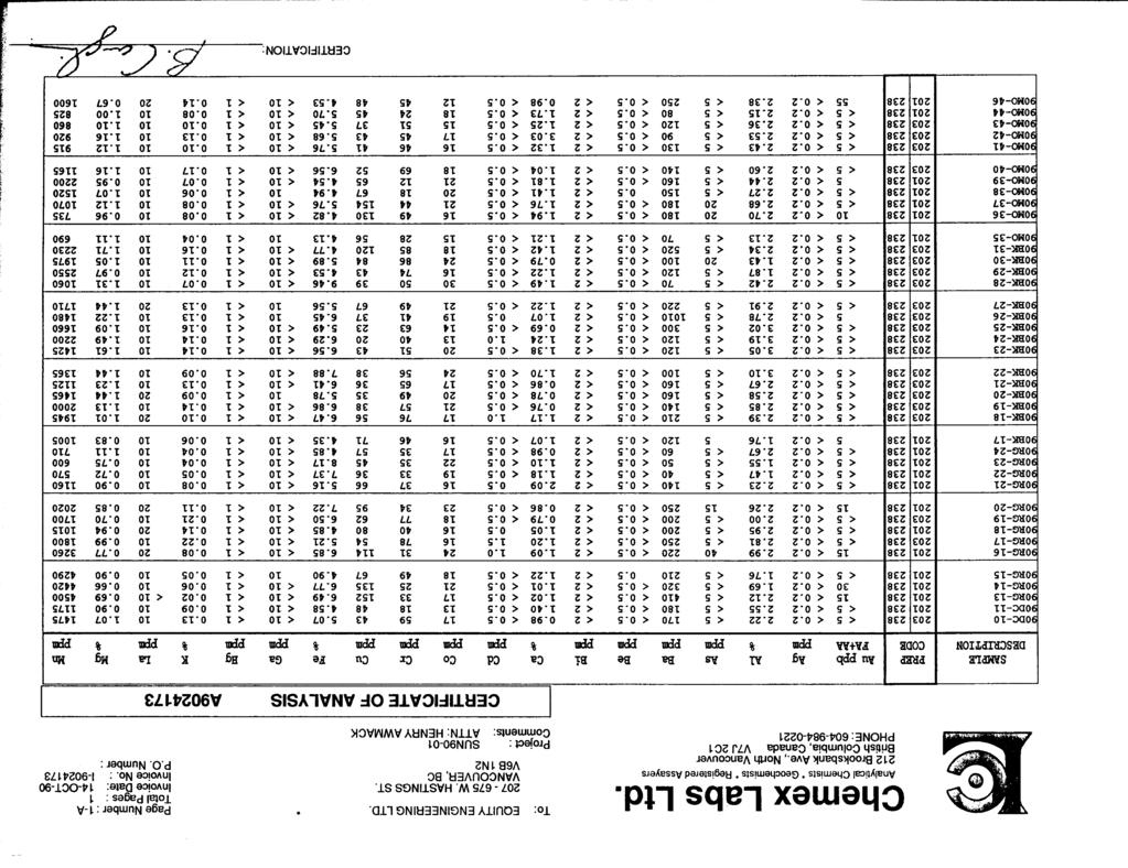
68
69
70
71
72
73
74
75

76

77
The Cobalt Rainbow. Airborne geophysical maps show that a north trending aeromagnetic high suggests further undiscovered mineralisation.
 The Cobalt Rainbow The property is located on Greenstone Creek, approximately 4.8 kilometres south west of the creek mouth. The property is located about 24 km due west of Campbell River, in the east-central
GEOLOGY OF THE NICOLA GROUP BETWEEN MISSEZULA LAKE AND ALLISON LAKE
 GEOLOGY OF THE NICOLA GROUP BETWEEN MISSEZULA LAKE AND ALLISON LAKE (92H/15E. 10E1 By V. A. Preto INTRODUCTION Mapping was continued southward from the area covered in 1973 and an additional 55 square
PROSPECTORS ASSISTANCE PROGRAM MINISTRY OF ENERGY AND MINES
 BRITISH COLUMBIA PROSPECTORS ASSISTANCE PROGRAM MINISTRY OF ENERGY AND MINES GEOLOGICAL SURVEY BRANCH PROGRAM YEAR: 1999/2000 REPORT #: PAP 99-l 6 NAME: KIM ANSCHETZ PROSPECTORS TlEPORT on the 99 LOUIS
NEW HAZELTON, OMINECA M.D.,
 PROSPECTING REPORT JUDI 1 TO 6 MINERAL CLAIMS NEW HAZELTON, OMINECA M.D., B.C. MAP 93M/4E, LAT. SS014'N, LONG. 127'33'W OWNED BY: A. L'ORSA ANTHONY L'ORSA Smithers, B.C. 21 February, 1981 TABLE OF CONTENTS
DISCOVERY OF MINERALISED PORPHYRY & MAGNETITE-COPPER-GOLD AT KAMARANGAN
 MEDUSA MINING LIMITED ABN: 60 099 377 849 Unit 7, 11 Preston Street Como WA 6152 PO Box 860 Canning Bridge WA 6153 Telephone: +618-9367 0601 Facsimile: +618-9367 0602 Email: admin@medusamining.com.au Internet:
PROSPECTING REPORT. Medallion Property. EVENT # TENURE # Tenure Name: GPEX CLVIII Medallion
 2006-2007 PROSPECTING REPORT Medallion Property EVENT # 4167980 TENURE # 540362 Tenure Name: GPEX CLVIII Medallion Watson Bar Region Clinton Mining Division Map 092O Central Coordinate Reference Long.
GEOLOGY AND LITHOGEOCHEMISTRY OF THE CHILKO-TASEKO LAKES AREA* BY G.
 B Ministry of Energy, Mines and Petroleum Resources GEOLOGICAL BRANCH MINERAL RESOURCES DIVISION NOTES TO ACCOMPANY OPEN FILE - GEOLOGY AND LITHOGEOCHEMISTRY OF THE CHILKO-TASEKO LAKES AREA* BY G. P. McLAREN
ASSESSMENT REPORT GEOLOGICAL BRANCH. 50' 23 'North. GEOLOGICAL and GEOCHEMICAL SURVEYS ON THE. PUTNAM PROPERTY (Putnam Mineral Claim)
") GEOLOGICAL and GEOCHEMICAL SURVEYS ON THE PUTNAM PROPERTY (Putnam Mineral Claim) VERNON MINING DIVISION, B.C. GEOLOGICAL BRANCH ASSESSMENT REPORT NTS : Latitude: 82L17W 50' 23 'North LOCATION, ACCESS,
GEOLOGICAL and GEOCHEMICAL SURVEYS ON THE PUTNAM PROPERTY (Putnam Mineral Claim) VERNON MINING DIVISION, B.C. GEOLOGICAL BRANCH ASSESSMENT REPORT NTS : Latitude: 82L17W 50' 23 'North LOCATION, ACCESS,
2013 GEOLOGICAL ASSESSMENT REPORT SHERIDAN HILL PROPERTY
 2013 GEOLOGICAL ASSESSMENT REPORT ON THE SHERIDAN HILL PROPERTY NEW WESTMINSTER MINING DIVISION BRITISH COLUMBIA NTS 092G07 49 16 31 NORTH LATITUDE, 122 39 48 WEST LONGITUDE PREPARED FOR Sheridan Hill
490 20' 30" North Latitude ' 30" West Longitude
 _._.. I CONSULTING GEOLOGISTS 605-602 WEST HASTINGS STREET, VANCOUVER, B.C. V6B 1P2 TELEPHONE: (604) 689-5533 6 I F: ASSESSMENT REPORT ON THE PATSY 1 MINERAL CLAIM ' '?%2% I WHISTLE CREEK, HEDLEY ARE L-l-
=%REPORT RECONNAISSANCE OF CHISHOLM LAKE PROSPECT. October 25, 1977
 =%REPORT ON FIELD RECONNAISSANCE OF CHISHOLM LAKE PROSPECT October 25, 1977 Bruce D. Vincent Imperial Oil Limited, Minerals - Coal, CALGARY, ALBERTA CHISHOLM LAKE PROSPECT Introduction The Chisholm Lake
Prospecting Report 'S Office i DB Property, B.C. -J Negro Creek Nelson Mining District NTS 82F.050. Operator: Kootenay Gold Inc.
 . '.' I"' i9 12 Prospecting Report 'S Office i DB Property, B.C. -J Negro Creek Nelson Mining District NTS 82F.050 Operator: Kootenay Gold Inc. Owner: Darlene Lavoie Work Performed Summer of 2007 Report
GEOLOGICAL MAPPING REPORT ON THE ASH MINERAL CLAIM OSOYOOS MINING DIVISION ASHNOLA RIVER MAP SHEET NTS M092,H019 MCBRIDE CREEK AREA, ASHNOLA RIVER,
 GEOLOGICAL MAPPING REPORT ON THE ASH MINERAL CLAIM OSOYOOS MINING DIVISION ASHNOLA RIVER MAP SHEET NTS M092,H019 LATITUDE 49 o O6, LONGITUDE 120 o 22 MCBRIDE CREEK AREA, ASHNOLA RIVER, KEREMEOS, B.C. CANADA
ARGENTINE FRONTIER RESOURCES INC (AFRI) SALTA EXPLORACIONES SA (SESA)
 SALTA EXPLORACIONES SA (SESA)") ARGENTINE FRONTIER RESOURCES INC (AFRI) SALTA EXPLORACIONES SA (SESA) LA SARITA IOCG-Porphyry Copper-Gold August 2006 La Sarita Cateo 2 La Sarita - bleached center is Taca Taca Arriba. The hematite zone
ARGENTINE FRONTIER RESOURCES INC (AFRI) SALTA EXPLORACIONES SA (SESA) LA SARITA IOCG-Porphyry Copper-Gold August 2006 La Sarita Cateo 2 La Sarita - bleached center is Taca Taca Arriba. The hematite zone
The MAPLE BAY PROJECT Copper Silver - Gold
 The MAPLE BAY PROJECT Copper Silver - Gold Good grade and tonnage potential within close proximity to Tidewater The Maple Bay Copper Silver Gold Project covers highly favourable geological host rocks of
ASSESSMENT REPORT PROSPECTING PROGRAM ION/DIRTY JACK PROPERTY NELSON MINING DIVISION N.T.S. MAP SHEET 82F.023 UTM COORDINATES N E
 ASSESSMENT REPORT PROSPECTING PROGRAM ION/DIRTY JACK PROPERTY NELSON MINING DIVISION N.T.S. MAP SHEET 82F.023 UTM COORDINATES 5454800N - 0455235E Work Performed Summer 2007 OWNER >* ' Tom Kennedy >8 404-22
GOLDCLIFF TULAMEEN PORPHYRY COPPER PROJECT COPPER MOUNTAIN CAMP, BRITISH COLUMBIA THE TROJAN-CONDOR COPPER TARGET HIGHLIGHTS
 Suite 350-885 Dunsmuir Street PF 250 764 8879 TF 866 769 4802 Vancouver, BC, Canada FX604 261 8994 info@goldcliff.com V6C 1N5 GCN.TSXV www.goldcliff.com GOLDCLIFF TULAMEEN PORPHYRY COPPER PROJECT COPPER
FIRST YEAR ASSESSMENT REPORT PROSPECTING LICENCE 16512M MARYSTOWN AREA, BURIN PENINSULA NTS 1M/3
 FIRST YEAR ASSESSMENT REPORT OF PROSPECTING ON LICENCE 16512M MARYSTOWN AREA, BURIN PENINSULA NTS 1M/3 BY NATHANIEL NOEL MSc. FOR E. MICHELE NOEL MINERAL LICENCES: 16512 M WORK CONDUCTED: MID-SEPTEMBER
Serengeti Resources Inc GEOCHEMICAL REPORT ON THE SHADOW PROPERTY a.
 Serengeti Resources Inc. 2004 GEOCHEMICAL REPORT ON THE SHADOW PROPERTY a. Located in the Johanson Lake Area Omenica Mining Division NTS 94D/9 6 degrees and 32 minutes North Latitude 126 degrees and 2
Structural Analysis Using Hillshade Imagery. on the. LLC Property
 Structural Analysis Using Hillshade Imagery on the LLC Property Liard Mining Division NTS 104F/16W Latitude: 57 53' 47'' N Longitude: 132 03' 06'' W Owner Garry John Payie 3714 Raymond Street South, Victoria,
1 FILMED 1. FILE NO:!..rsrru -* -. GRAND TWO CLAIM
 FILE NO:!..rsrru -* -. GRAND TWO CLAIM REPORT ON 1993 ASSESSMENT WORK GRAND TWO CLAIM REC. NO. 301849 NELSON MINING DIVISION NTS MAP SHEET 82F6/W 49 25'51" NORTH 117 18'08" WEST 1 FILMED 1 AUTHOR: R. Jordan,
ASSESSMENT REPORT ON THE PEAVINE PROJECT. DGW & Associates # Alberni Street, Vancouver, British Columbia, V6E 4V2
 ASSESSMENT REPORT ON THE PEAVINE PROJECT KAMLOOPS MINING DIVISION BRITISH COLUMBIA NTS 082M 12 Latitude 51 36' 19.0"North -- Longitude --119 47' 27.0"West UTM Zone 11, NAD 83 5720827N 306744E Prepared
BCGold Corp. Discovery Driven
 BCGold Corp. Discovery Driven Sickle-Sofia Property Copper-Gold Porphyry Discovery in the Toodoggone Camp! Cautionary Statement This presentation does not constitute an offer to sell or solicitation of
twd$ yqsi+hca
 -t@~cl--t,i twd$ yqsi+hca C ASSESSMENT REPORT ON THE OR0 1-5 CLAIMS NEAR GOLDBRIDGE, B.C. Lillooet Mining Division N.T.S. 92 J / 15 W Long. 122 51.5 W. Lat. 50 47.5 N. Owned by Levon Resources Ltd. Optioned
%+ '$# $) %, %*$ " $ $ ' %' !()'-!" %( %"%! " *'+ - % %$! $)! " $)!" !$ ' "! )( ! $ '%& ')- % % "!#( (( ((# $) ' ) ((* & *# ' % %"*# ( !!
 %, %*$ $ $ ' %' !()'-! %( %%! *'+ - % %$! $)! $)! !$ ' ! )( ! $ '%& ')- % % !#( (( ((# $) ' ) ((* & *# ' % %*# ( !!") 001L/14/0218 First Year Assessment Report of Prospecting, Rock and Stream Sediment Sampling On Licence 18880M, NTS 1L/14 Burin Peninsula Newfoundland and Labrador Submitted by: Keith Kelloway Work year:
001L/14/0218 First Year Assessment Report of Prospecting, Rock and Stream Sediment Sampling On Licence 18880M, NTS 1L/14 Burin Peninsula Newfoundland and Labrador Submitted by: Keith Kelloway Work year:
entire 1.5 meter drift width
 GOLD HILL SUMMARY In 1864 gold fever struck in the south Kootenays east of Cranbrook, British Columbia as placer gold was discovered in the Wild Horse River. What followed was everything one can imagine
Lat. 52' 43' N Long ' W
 &A exploration ltd MINING ENGINEERING GEOLOGY- GEOPHYSICS 4570 HOSKINS ROAD, NORTH VANCOUVER, 6. C. TELEPHONE (804) 985,7921 V7K 2R1 GEOLOGICAL AND GEOCHEMICAL REPORT on the BLUE CLAIMS Cariboo Mining
Beekeeper Property The Geology South of Mint Lake. Cariboo Mining Division
 Beekeeper Property The Geology South of Mint Lake NTS: 93A/6 Cariboo Mining Division Claims: Beekeeper 1 #I2055 Beekeeper 2 #3892 Beekeeper 3 #7895 Beekeeper 4 #8503 Latitude: Longitude: 52 degrees 24
Lands Parcels in IOL CO-20
 Lands Parcels in IOL CO-20 1 CO-20 The Izok Corridor Lupin - multi-million ounce past gold production (3.6 million oz of gold at average grade of 9.3 g/t Au) Approximately 1 million ounces of undeveloped
for the Greenwood Mining Division, B.C. NTS 82E/7W 29' W, Longitude 118' 53' N Prepared by D. Dylan Watt, B.Sc.
 for the FltE NO: u VOLT 1, VOLT 2, VOLT 3, & VOLT 4 CLAIMS Greenwood Mining Division, B.C. NTS 82E/7W Latitude 49' 29' W, Longitude 118' 53' N Prepared by D. Dylan Watt, B.Sc. #309-1996 Trutch Street Vancouver,
3. GEOLOGY. 3.1 Introduction. 3.2 Results and Discussion Regional Geology Surficial Geology Mine Study Area
 3. GEOLOGY 3.1 Introduction This chapter discusses the baseline study of the geology and mineralization characteristics of the mine study area. The study consolidates existing geological data and exploration
HOWE COPPER MINE PROJECT HIGH GRADE Cu-Ag with Au
 HOWE COPPER MINE PROJECT HIGH GRADE Cu-Ag with Au The Howe Copper Mine property is located approximately 55 kilometres northwest of Vancouver, BC. It is situated at 1431 metres elevation on the eastern
CARIBOO - GRIZZLY ZINC PROJECT
 CARIBOO - GRIZZLY ZINC PROJECT The Grizzly Lake or Cariboo Zinc property straddles the gravel Weldwood 8400 logging road in the Grizzly Lake area about 55 kilometres northeast of Likely. Roads constructed
GEOLOGIC SETTING OF THE WADSWORTH VEIN: AN INTRUSIVE-RELATED GOLD DISCOVERY NEAR TERRACE, B.C.
 WADSWORTH VEIN By Paul J. Wojdak, Wayne Bulmer and Daryl J. Hanson LOCATION: Lat. 54 57 33 N Long. 128 50 09 W (103I/15W) CLAIMS: ACCESS: SKEENA MINING DIVISION. The property is located in the Cedar River
PROSPECTING REPORT. Silver Dollar Property. EVENT # TENURE # Tenure Name: GPEX Silver Dollar
 2008-2009 PROSPECTING REPORT Silver Dollar Property EVENT # 4267989 TENURE # 555462 Tenure Name: GPEX Silver Dollar Similkameen Mining Division Map 092H Central Coordinate Reference 120 06 26.9 W Longitude
for the Greenwood Mining Division, B.C. NTS 82E/7W Latitude 49' 27' W, Longitude 118' 5 Prepared by a= D. Dylan Watt, B.Sc.
 t. b LOGnO: 37~ -08 m. ACTIO#: for the AMP AMP 2 AMP 3 t AMP 4 CLAIMS Greenwood Mining Division, B.C. NTS 82E/7W Latitude 49' 27' W, Longitude 8' 5 %E c,w zc *& a w Prepared by a= -4c. D. Dylan Watt, B.Sc.
Drill locations for the 2015 program are highlighted in the geology map below.
 2015 Exploration Program The exploration program plan at KSM for 2015 was designed to improve the understanding of block cave targets and support engineering/environmental aspects of development scenarios.
GEOLOGIC REPORT. on the. NTS- 92 L/ 12 co-ords 50~37.5'~ 127~32'~ Owned by UTAH MINES LTD. GORDON MILBOURNE. Operator UTAH MINES LTD.
 GEOLOGIC REPORT on the " - SUNSET GROUP OF CLAIMS NTS- 92 L/ 12 co-ords 50~37.5'~ 127~32'~ Owned by UTAH MINES LTD. & GORDON MILBOURNE Operator UTAH MINES LTD. BY G.L. Holland Geol ogi st June 15, 1983
MUDDY LAKE PROSPECT (104WlW)
") MUDDY LAKE PROSPECT (104WlW) BY T. G. Schroeter INTRODUCTION The Muddy Lake gold property consists primarily of the Bear and Totem group of claims and is located 137 kilometres west of Deasc! Lake at latitude
MUDDY LAKE PROSPECT (104WlW) BY T. G. Schroeter INTRODUCTION The Muddy Lake gold property consists primarily of the Bear and Totem group of claims and is located 137 kilometres west of Deasc! Lake at latitude
ON THE LOST GOLD PROPERTY
 ON THE LOST GOLD PROPERTY NELSON MINING DIVISION BRITISH COLUMBIA Latitude: 49 18 North Longitude: 117 29.West TRIM MAPS: 82F1023,033 NTS: 8tF/5,6 By: Fred Critchlow . TABLE OF CONTENTS r PAGE lutroduction
COPPERSTONE RESOURCES AB INTERCEPTS ZONE OF CHALCOPYRITE-ARSENOPYRITE- BORNITE MINERALIZATION AT SVARTLIDEN IN FIRST DEEP DRILLHOLE FROM 720m-810m
 COPPERSTONE RESOURCES AB INTERCEPTS ZONE OF CHALCOPYRITE-ARSENOPYRITE- BORNITE MINERALIZATION AT SVARTLIDEN IN FIRST DEEP DRILLHOLE FROM 720m-810m In mid-january 2017 Copperstone Resource published a geological
SECOND DRILL HOLE IHAD2 INTERSECTS MINERALIZED TAPLEY HILL FORMATION AND MINERALIZED BASEMENT IRON FORMATION
 Suite 304, 22 St Kilda Road St Kilda Vic 3182 Ph: +61 3 9692 7222; Fax: +61 3 9529 8057 For Immediate Release 14 th September 2007 SECOND DRILL HOLE IHAD2 INTERSECTS MINERALIZED TAPLEY HILL FORMATION AND
For personal use only
 ANNOUNCEMENT TO THE AUSTRALIAN SECURITIES EXCHANGE: 28 NOVEMBER 2012 DRILLING UPDATE MABILO PROJECT The Directors of Sierra Mining Limited ( Sierra ) are pleased to announce further results from reconnaissance
32?un North of Hope, B.C.,
 Geological Reconnaissance Assessment Report on portions of the Gilt Creek Group (Mike, C.G., Julie, and Gilt Mineral Claims) Situated 32?un North of Hope, B.C., New Westminster Mining Division N 'P 97H/11W
KENNCO EXPLORATIONS, (WESTERN) LIMITED REPORT GEOLOGICAL & GEOCHEMICAL SURVEYS SEAN CLAIMS
 LIMITED REPORT GEOLOGICAL & GEOCHEMICAL SURVEYS SEAN CLAIMS") KENNCO EXPLORATIONS, (WESTERN) LIMITED REPORT GEOLOGICAL & GEOCHEMICAL SURVEYS SEAN CLAIMS Situated 24 mi. S20 E of Houston, Omineca Mining Division, British Columbia 54'05'N, 126'27'W Matti Tavela Under
KENNCO EXPLORATIONS, (WESTERN) LIMITED REPORT GEOLOGICAL & GEOCHEMICAL SURVEYS SEAN CLAIMS Situated 24 mi. S20 E of Houston, Omineca Mining Division, British Columbia 54'05'N, 126'27'W Matti Tavela Under
PRECIOUS METALS. owner. JMT Services Corp. GEOCHPlICAL SAMPLING CHELASLIE WCE, NORTH CENTRAL, B.C. OMINECA MINING DIVISION NTS 93F/5E & 6W
 PRECIOUS METALS REPORT ON 1980 RECONNAISSANCE GEOCHPlICAL SAMPLING CHELASLIE WCE, NORTH CENTRAL, B.C. OMINECA MINING DIVISION NTS 93F/5E & 6W LATITUDE 53O28 N LONGITUDE 125O31 W DATES Qp WORK: JULY 10
ISKUT RIVER - TELEGRAPH CREEK: NEW EXPLORATION OPPORTUNITIES IN THE BC REGIONAL GEOCHEMICAL DATABASE
 ISKUT RIVER - TELEGRAPH CREEK: NEW EXPLORATION OPPORTUNITIES IN THE BC REGIONAL GEOCHEMICAL DATABASE By Ray Lett 1 and Wayne Jackaman 2 KEYWORDS: Regional stream sediment surveys, archival samples, gold,
First Year Assessment Report: Report on Prospecting, Rock and Soil Sampling Carried Out From September/2012 to December/2012.
 First Year Assessment Report: Report on Prospecting, Rock and Soil Sampling Carried Out From September/2012 to December/2012 on the Clarkes Pond Property Licence 020334M Northwest Gander River,Central
on the SALAL CREEK MOLYBDENUM PROPERTY, SALAL CREEK, B.C. LILLOOET MINING DIVISION, BRITISH COLUMBIA
 on the J PLUG 9-12, PLUG 19-24, BAT 10-14, BAT 15 Fr., BAT 16 Fr. MINERAL CLAIMS, SALAL CREEK MOLYBDENUM PROPERTY, SALAL CREEK, B.C. LILLOOET MINING DIVISION, BRITISH COLUMBIA N.T.S. 92 J 14 LATITUDE 50
CONTENTS. Location, Access and History...6. Tenure Status and Geology Regional Andy Property Geology Map...9
 TYPE OFWORK IN THIS REPORT EXTENT OF WORK (rn METRTC UNITS) ON WHICH CLAIMS PROJECT COSTS APPORTIONED (incl. support) GEOLOGICAL (scale, area) Ground, mapping Photo interpretation GEOPHYSICAL (line-kilometres)
MEMO. TO: Dennis Lapoint CC: FROM: Eriaan Wirosono DATE: April, 20 th 2014 SUBJECT: Exploration activity report March-April 2014_EW
 TO: Dennis Lapoint CC: FROM: Eriaan Wirosono DATE: April, 20 th 2014 SUBJECT: Exploration activity report March-April 2014_EW MEMO 1. Highlights and Productivity Overview pan sampling on target Areas 1
ASSESSMENT REPORT. Geochemical and Geological Surveys. on the. Gooch#1-4. Mineral Claims. Omenica Mining District NTS 93L/7W
 f- GEOLOGICAL BRANCH ASSESSMENT REPORT ASSESSMENT REPORT Geochemical and Geological Surveys on the Gooch#1-4 Mineral Claims Omenica Mining District NTS 93L/7W LAT: 54O25'W LONG: 126O26'W Operator: SMD
GEOLOGICAL MAPPING OF SKARNS ON THE SHEEP AND EWE CLAIMS, TURNAGAIN RIVER, B.C. DURING THE 1979 SUMMER SEASON
 GEOLOGICAL MAPPING OF SKARNS ON THE SHEEP AND EWE CLAIMS, TURNAGAIN RIVER, B.C. DURING THE 1979 SUMMER SEASON CLAIMS: Sheep 1 to 4 Ewe 1, 3, 4 to 8 Lamb 12 Fraction Liard Mining Division, B.C. NTS 104
CSA Mine Observations Applied to the Development of Regional Exploration Models
 CSA Mine Observations Applied to the Development of Regional Exploration Models 1 Introduction Recent work completed by the geology team has resulted in an improved understanding of the CSA mine system
PROSPECTING REPORT. Broken Hill Property. EVENT # TENURE # Tenure Name: Broken Hill. New Westminster Mining Division Map 092H
 2009-2010 PROSPECTING REPORT Broken Hill Property EVENT # 4514071 TENURE # 600988 Tenure Name: Broken Hill New Westminster Mining Division Map 092H Central Coordinate Reference 121 24 26.2 W Longitude
SECOND and THIRD YEAR ASSESSMENT REPORT PROSPECTING LICENCE M, ROCK CUT PROPERTY, NTS 1N/12, NEWFOUNDLAND. ROY FRENCH (licence holder )
") SECOND and THIRD YEAR ASSESSMENT REPORT Of PROSPECTING On LICENCE 013704M, ROCK CUT PROPERTY, NTS 1N/12, NEWFOUNDLAND. By ROY FRENCH (licence holder ) Work Conducted: Sept. 17, 2008 Nov. 03, 2009 Total
SECOND and THIRD YEAR ASSESSMENT REPORT Of PROSPECTING On LICENCE 013704M, ROCK CUT PROPERTY, NTS 1N/12, NEWFOUNDLAND. By ROY FRENCH (licence holder ) Work Conducted: Sept. 17, 2008 Nov. 03, 2009 Total
MINFILE DETAILS. Occurrence Number: 105D 203 Occurrence Name: GRUMPY Occurrence Type: Hard-rock Status: Drilled Prospect
 MINFILE DETAILS Occurrence Number: 105D 203 Occurrence Name: GRUMPY Occurrence Type: Hard-rock Status: Drilled Prospect Aliases: Les 2 Deposit Type(s): Vein Polymetallic Ag-Pb-Zn+/-Au Location(s): 60 54'17.87"
Negro Creek Fort Steele Minina Division. CRAIG KENNEDY Prospector
 AUG and SKAY Claims Negro Creek Fort Steele Minina Division NTS 82 F8/E Latitude 49O28 N Lonqi tude 116 Ol W BY CRAIG KENNEDY Prospector September 5, 1996 TABLE OF CONTENTS Page 1.00 INTRODUCTION 1.10
REPORT. on the. Omineca Mining Division, British Columbia. Latitude N., Longitude W. NTS map sheet 93F/7E. James W. McLeod, P.Geo.
 REPORT on the CHU MOLYBDENUM PROPERTY Omineca Mining Division, British Columbia Latitude 53 21 N., Longitude 124 37 W. NTS map sheet 93F/7E James W. McLeod, P.Geo. on behalf of Mr. Chris Delorme TABLE
DSM SYNDICATE DISCOVERS POLYMETALLIC MINERALIZATION WITH TALUS GRAB SAMPLES CONTAINING UP TO PERCENT LEAD AND 18
 DSM SYNDICATE DISCOVERS POLYMETALLIC MINERALIZATION WITH TALUS GRAB SAMPLES CONTAINING UP TO 92.8 GRAMS PER TONNE GOLD, 13,643 GRAMS PER TONNE SILVER, 13.85 PERCENT LEAD AND 18.65 PERCENT COPPER FROM DIFFERENT
Regional geology map showing drill holes completed to date and hole RZDDH10 08 in progress, IP Chargeability anomalies hatched.
 Alteration Haloes Alteration facies in the Suarez-Misahuallí basin on the east side of the Rio Zarza gold project are complex, as they oerlap in time and space, are the result of weathering, diagenetic,
W. 1.NELSON Jr. P. ENG.
 GEOCHEMICAL AND GEOPHYSICAL SURVEY SNO GROUP CLAIMS W. 1.NELSON Jr. P. ENG. NORANDA EXPLORATION COMPANY, LIMITED OMINECA MINING DIVISION AUG. 17, 1971 - AUG. 29, 1971 TABLE OF CONTENTS - Page INTRODUCTION
Location/Identification
 MINFILE Detail Report BC Geological Survey Ministry of Energy, Mines and Natural Gas and Responsible for Housing Location/Identification MINFILE Number: 092L 178 National Mineral Inventory Number: 092L14
EXISTING GEOLOGICAL INFORMATION
 CHAPER 3 EXISTING GEOLOGICAL INFORMATION 3-1 General Geology of the Surrounding Area (1) General geology and ore deposits in Mongolia Geographically, Mongolia is a country located between Russia to the
Notes: Note. Township of GODSON Report NQ: 12. Diamond Dniiing. Hole NQ Footage Date. July/56. July/56. Aug/56. Aug/56. Claim NQ 487' K ' l-a
 Diamond Dniiing S2F«4NW«194 12 GODSON 010 Township of GODSON Report NQ: 12 Work performed by: KENNCO EXPLORATIONS (CANADA) LTD. Claim NQ Hole NQ Footage Date Note K 25434 l 487' July/56 l-a 48' July/56
First Year assessment Report on Prospecting and Rock sampling, King George property, License M NTS 12A/05 Newfoundland and Labrador.
 First Year assessment Report on Prospecting and Rock sampling, King George property, License 016679M NTS 12A/05 Newfoundland and Labrador. Submitted by Shawn Rose For Shawn Rose January 2011 Work year
POTENTIAL OF THE DONGWE COPPER GOLD PROJECT
 POTENTIAL OF THE DONGWE COPPER GOLD PROJECT By Nathan Sabao, P.Geo. September 2015 1 TABLE OF CONTENTS Page 1.0 EXECUTIVE SUMMARY 1 2.0 LOCATION 2 3.0 ACCESS 2 4.0 GEOLOGY 3 5.0 PREVIOUS DRILLING 5 6.0
VANCOUVER, B.C. Tri 082F/ F/059
 GEOCHEMCAL REPORT t MAY L, 2006 Whbpper Mineral Claims Ailsa Lake Area Gold comm~ss16fl8f"s Offim on Mining Division VANCOUVER, B.C. Tri 082F/058 082F/059 3792 E 5486438 N Operator Kootenay Gold nc. Suite
ASX Announcement. 28 January Drill results indicate large Porphyry Copper Gold System at Peenam
 ASX Announcement 28 January 2010 Drill results indicate large Porphyry Copper Gold System at Peenam Highlights: 270 metres of visible copper (gold) mineralisation in first diamond core hole at Peenam Prospect
The Gold Hill s Big Chief Showing. Cross Section Line A-A' (Pighin 2014)
") GOLD HILL SUMMARY In 1864 gold fever struck in the south Kootenays east of Cranbrook, British Columbia as placer gold was discovered in the Wild Horse River. What followed was everything one can imagine
GOLD HILL SUMMARY In 1864 gold fever struck in the south Kootenays east of Cranbrook, British Columbia as placer gold was discovered in the Wild Horse River. What followed was everything one can imagine
TABLE OF CONTENTS. Page A. INTRODUCTION 1 B. LOCATION AND ACCESS 2 C. CLAIM INFORMATION 2 D. BRIEF HISTORY 3 E. REGIONAL GEOLOGICAL FRAMEWORK 4
 TABLE OF CONTENTS Page A. INTRODUCTION 1 B. LOCATION AND ACCESS 2 C. CLAIM INFORMATION 2 D. BRIEF HISTORY 3 E. REGIONAL GEOLOGICAL FRAMEWORK 4 F. RECONNAISSANCE BEDROCK GEOLOGY 5 G. FIELD PROCEDURES 5
UNION MINIERE EXPLORATIONS AND MINING CORPORATION LIMITED ASSESSMENT REPORT ON FITINAT MINERAL CLAIM. Alberni Mining Division Record No.
 M F )( UNION MINIERE EXPLORATIONS AND MINING CORPORATION LIMITED Suite 200, 4299 Canada Way, Burnaby, B.C. V5G 1 H4 Telephone (604) 437-9491 ASSESSMENT REPORT ON GEOCHEMICAL SOIL SURVEYS AND ROCKSAMPLING
Date Submitted: June General Nature of Report: Examination of Placer Samples
 General Nature of Report: Examination of Placer Samples Claim: Gold Channel, Record Number 3775!8 1 (Gold Channel Placer Property) Mining Division: Cariboo NTS 093 G 09 W and E Latitude 520 23 N' Longitude1210
1985 GEOLOGICAL AND GEOCHEMICAL REPORT
 COMINCO LTD. EXPLORATION NTS: 92G/9W/16W WESTERN DISTRICT ASSESSMENT REPORT 1985 GEOLOGICAL AND GEOCHEMICAL REPORT ON THE SLO 1 AND 2 MINERAL CLAIMS SLOQUET CREEK AREA - NEW WESTMINSTER MINING DIVISION
Golden Cross Resources
 Golden Cross Resources Labrador Uranium Joint Venture with Altius Resources Update - November 2007 Labrador Uranium - Canada LABRADOR URANIUM PROPERTIES Golden Cross Resources signed an agreement with
R.A. COMINCO LTD. EXPLORATION NTS: 92H/16. WESTERN DISTRICT January 6, 1982 ASSESSMENT REPORT 1981 SOIL GEOCHEMISTRY ON THE TROUT PROPERTY
 COMINCO LTD. EXPLORATION NTS: 92H/16 WESTERN DISTRICT January 6, 1982 ASSESSMENT REPORT 1981 SOIL GEOCHEMISTRY ON THE TROUT PROPERTY (Trout 1 and 6 Claims) SIWASH LAKE AREA, SIMILKAMEEN M.D., B.C. (Work
FILE NO. ASSESSMENT REPORT VLF-EM GEOPHY S I CS BUCK CLAIMS. Moyie River and Perry Creek Area FORT STEELE MINING DIVISION. NTS 82 F/8 E and 82 G/5 W
 FILE NO. ASSESSMENT REPORT on - VLF-EM GEOPHY S I CS BUCK CLAIMS Moyie River and Perry Creek Area FORT STEELE MINING DIVISION NTS 82 F/8 E and 82 G/5 W Latitude 49 27' N Longitude 116 03' W PETER KLEWCHUK
GEOCHEMICAL AND PROSPECTING REPORT. RC ly 2,3,4 CLAIMS
 p- ON GEOLOGlCAL SURVEY BRANCH ASSESSMENT REPORTS - DATE RECFl'dFD AFR 0 1 19% GEOCHEMICAL AND PROSPECTING REPORT THE RC ly 2,3,4 CLAIMS IARD MINING DIVISION BRIT1 S H COLUMBIA 94E/EI W LATITUDE 57" 48'
lat ' N Long ' W
 305 7 ec1;, REPORT ON THE JERY CLAIMS OF POLA RESOURCES LTD. NTS 93L/16 0 0 lat. 54 45' N Long. 126 22' W BABIXE LAKE AREA OMINECA MINING DIVISION, B.C. PAUL PLICKA CONSULTING GEOLOGIST DECEMBER 30, 1981
003Y30RN W
 W ENGINEER CLAIMS REPORT ON PRELIMINARY GEOLOGICAL MAPPING AND GEOCHEMICAL SAMPLING ENGINEER 1,2,3, dt 4 CLAIMS LILLOOET MINING DIVISION NTS MAP SHEET 92511 E - ; 003Y30RN 123001 15 W I AND PETROLEUM RESOURCES
VECTORING VOLCANOGENIC MASSIVE SULPHIDE MINERALIZATION AT THE RAINDROP ZONE, SNOW LAKE (NTS 63K16), MANITOBA by G.H. Gale
, MANITOBA by G.H. Gale") GS-8 VECTORING VOLCANOGENIC MASSIVE SULPHIDE MINERALIZATION AT THE RAINDROP ZONE, SNOW LAKE (NTS 63K16), MANITOBA by G.H. Gale Gale, G.H. 2002: Vectoring volcanogenic massive sulphide mineralization at
GS-8 VECTORING VOLCANOGENIC MASSIVE SULPHIDE MINERALIZATION AT THE RAINDROP ZONE, SNOW LAKE (NTS 63K16), MANITOBA by G.H. Gale Gale, G.H. 2002: Vectoring volcanogenic massive sulphide mineralization at
Geology 12 FINAL EXAM PREP. Possible Written Response Exam Questions
 Geology 12 FINAL EXAM PREP Possible Written Response Exam Questions Use this study guide to prepare for the written response portion of the final exam. Name FINAL EXAM - POSSIBLE WRITTEN RESPONSE QUESTIONS
Wind Mountain Project Summary Memo Feeder Program
 A Manex Resource Group Company Wind Mountain Project Summary Memo Feeder Program J.A. Kizis, Jr., February 07, 2018 Assays have been received for both holes drilled at Wind Mountain during late 2017 and
Tameapa Regional Geology
 Tameapa Project 1 Tameapa Regional Geology History San Francisco Mines of Mexico Ltd. (San Francisco), which completed an exploration program, including six drill holes (1,157 m) between 1956 and 1959.
IVANHOE DISCOVERS IMPORTANT NEW GOLD-COPPER PORPHYRY DISTRICT IN SOUTHERN MONGOLIA NEW PORPHYRY DISTRICT NOW NAMED BRONZE FOX
 November 29, 2004 IVANHOE DISCOVERS IMPORTANT NEW GOLD-COPPER PORPHYRY DISTRICT IN SOUTHERN MONGOLIA NEW PORPHYRY DISTRICT NOW NAMED BRONZE FOX ULAANBAATAR, MONGOLIA Ivanhoe Mines Chairman Robert Friedland
Geoloqv Assessment ReDort. Heather ProDertv. Victoria Mining Division NTS 92C/15, 16
 Litr NO: 03 04 ACTION: RO. FILE No: Geoloqv Assessment ReDort Heather ProDertv Victoria Mining Division NTS 92C/15, 16 48' 59' N Latitude 124' 30' W Longitude Owner: Minnova Inc. Operator: Minnova Inc.,
ON THE GEOLOGICAL AND MAGNETOMETER SURVEYS ON THE FANG NO. 1 TO 9 AND NO. 10 FRACTION MINERAL CLAIMS PROJECT 6051 N.T.S.
 AN INTERIM REPORT ON THE GEOLOGICAL AND MAGNETOMETER SURVEYS ON THE FANG NO. 1 TO 9 AND NO. 10 FRACTION MINERAL CLAIMS PROJECT 6051 LAT.~o'~~' LONG. 127'33' 8 MILES SOUTHWEST OF PORT ALICE, B.C. N.T.S.
BALFOUR MINING LTD. (N.P.L.) HAM GROUP 92-P-6, CLINTON M. D.8 B. C. Lat 51 17'N, GEOCHEMICAL REPORT. V. CUKOR, P. Eng.
 HAM GROUP 92-P-6, CLINTON M. D.8 B. C. Lat 51 17'N, GEOCHEMICAL REPORT. V. CUKOR, P. Eng.") 34q '7 BALFOUR MINING LTD. (N.P.L.) HAM GROUP 92-P-6, CLINTON M. D.8 B. C. Lat 51 17'N, Long 12lo14'W GEOCHEMICAL REPORT, V. CUKOR, P. Eng. January 31, 1972 TABLE OF CONTENTS 1. INTRODUCTION 2. PROPERTY,
34q '7 BALFOUR MINING LTD. (N.P.L.) HAM GROUP 92-P-6, CLINTON M. D.8 B. C. Lat 51 17'N, Long 12lo14'W GEOCHEMICAL REPORT, V. CUKOR, P. Eng. January 31, 1972 TABLE OF CONTENTS 1. INTRODUCTION 2. PROPERTY,
Longitude W
 APRIL GEOLOGICAL AND GEOCHEMICAL REPORT on the APRIL MINERAL CLAIMS Skeena Mining Division Lye11 Island, Queen Charlotte Islands, B.C. NTS 103B/12E Latitude 52O41 IN Longitude 13 1 4 1 W Dates of Work:
BLURTON CREEK NICKEL PROPERTY. (Minfile # 082LNW-039)
") 5489153 BLURTON CREEK NICKEL PROPERTY (Minfile # 082LNW-039) Mara Lake Area / Salmon Arm B.C NTS - 82L-11 (UTM 83/Z10, 357690E, 5614220N) Prepared by: Jim Cuttle, B.Sc., P.Geo. 86 Cloudburst Road Whistler,
5489153 BLURTON CREEK NICKEL PROPERTY (Minfile # 082LNW-039) Mara Lake Area / Salmon Arm B.C NTS - 82L-11 (UTM 83/Z10, 357690E, 5614220N) Prepared by: Jim Cuttle, B.Sc., P.Geo. 86 Cloudburst Road Whistler,
Daiwan Engineering Ltd Granville strees V.ncouver, B. C. cuudr WY 1GS. M e : (604) PROSPECTING REPORT ON THE KING MINERAL CLAIMS
 PROSPECTING REPORT ON THE KING MINERAL CLAIMS") 1030-609 Granville strees V.ncouver, B. C. cuudr WY 1GS M e : (604) 688-1508 PROSPECTING REPORT ON THE KING MINERAL CLAIMS NORTH VANCOUVER ISLAND, BRITISH COLUMBIA NTS: 92Lj13E Latitude: 50" 47' Longitude:
1030-609 Granville strees V.ncouver, B. C. cuudr WY 1GS M e : (604) 688-1508 PROSPECTING REPORT ON THE KING MINERAL CLAIMS NORTH VANCOUVER ISLAND, BRITISH COLUMBIA NTS: 92Lj13E Latitude: 50" 47' Longitude:
Geochemical exploration on the Tareek Darreh Gold deposit, north of Torbat-e Jaam, east Iran
 Geochemical exploration on the Tareek Darreh Gold deposit, north of Torbat-e Jaam, east Iran Kourosh Shabani, M.Sc. Student of Economic Geology, Islamic Azad University, Science and Research Branch, Tehran,
Reconnaissance. Of the. Denis mineral claims. Situated at Kilometer 844 of the Alaska Highway. Liard Mining Division. Northeastern British Columbia
 Reconnaissance Of the Denis mineral claims Situated at Kilometer 844 of the Alaska Highway Liard Mining Division Northeastern British Columbia N.T.S. 94M.075 Latitude 59 42 25 Longitude 127 13 12 Field
Geological & Geophysical Interpretation of ZTEM EM and Magnetic Survey. Kemess Project, BC. for AuRico Metals Inc. September, 2016 Nicole Pendrigh
 Geological & Geophysical Interpretation of ZTEM EM and Magnetic Survey Kemess Project, BC for AuRico Metals Inc. September, 2016 Nicole Pendrigh SUMMARY REPORT Regional setting Located in North central
-prepared by- Ann L. Doyle, Geologist David A. Caulfield, F.G.A.C December, 1990
 I -prepared for- PASS LAKE RESOURCES LTD. -prepared by- Ann L. Doyle, Geologist David A. Caulfield, F.G.A.C December, 990 I 990 GEOLOGICAL AND GEOCHEMICAL REPORT ON THE CUDS 5-8 CLAIMS TABLE OF CONTENTS.0
BAROBO MINERALISED CORRIDOR
 MEDUSA MINING LIMITED ABN: 60 099 377 849 Unit 7, 11 Preston Street Como WA 6152 PO Box 860 Canning Bridge WA 6153 Telephone: +618-9367 0601 Facsimile: +618-9367 0602 Email: admin@medusamining.com.au Internet:
Geology, Alteration and. Petrogenesis
 The Mutooroo Copper Deposit: Geology, Alteration and Petrogenesis Graham S. Teale Consultant t Andrew T. Price Havilah Resources NL The speaker would like to thank Havilah Resources NL for the opportunity
NTS 082F03SW N W U E N
 Prospecting Report JOCELYN CLAIM NTS 082F03SW N49 09 51 W 117 14 04 11U 482906E 5445737N NELSON MINING DIVISION Martin Ross PO Box 323 Salmo BC V0G 1Z0 Jan 31, 2012 PROSPECTING REPORT JOCELYN MINERAL CLAIM
NOA ASSESSMENT HARRIS QUARRY MENDOCINO COUNTY, CALIFORNIA TABLE OF CONTENTS
 NOA ASSESSMENT HARRIS QUARRY MENDOCINO COUNTY, CALIFORNIA TABLE OF CONTENTS Introduction... 1 Scope of Services... 1 Project Location and Description... 1 Geologic Setting... 1 Regional Geology... 1 Site
Mishi Lake Gold Property Mishibishu Lake Area, Wawa
 Mishi Lake Gold Property Mishibishu Lake Area, Wawa Location, Accessibility, Infrastructure and Local Resources The property is located 40 km west of Wawa, Ontario, in the Mishibishu Lake Area, Sault Ste.