UNIT 11 SOUTH ASIA SG 1 - PHYSICAL GEOGRAPHY & THE ENVIRONMENT
|
|
|
- Chloe Sparks
- 6 years ago
- Views:
Transcription
1 UNIT 11 SOUTH ASIA SG 1 - PHYSICAL GEOGRAPHY & THE ENVIRONMENT
2 I. PHYSICAL GEOGRAPHY TAKE OUT YOUR PHYSICAL MAP OF SOUTH ASIA A. The Himalayan Mountains form the northern boundary of the region (color in brown). 1. The world s tallest mountain peaks are found in the Himalayas including the tallest mountain (by elevation), Mt. Everest at 29,035 ft. above sea level. (1:08-3:15 & 5:43-6:25) 2. Snow melt from the mountains feeds many of the major river system as well as moving sediment.
3 B. Rock fragments & particles have built up deposits of alluvium (about 10,000 ft) in the river basins (Indus, Ganges, & Brahmaputra flood plains) (outline rivers in blue; shade in plains in light green) 1. The Ganges & Brahmaputra join to form a huge delta of low-lying, flood-prone land that occupies most of Bangladesh (major natural hazard for Bangladesh). 2. These plains are now densely populated and intensively farmed.

4 Types of alluvial sediment from course sand to clay. ALLUVIUM
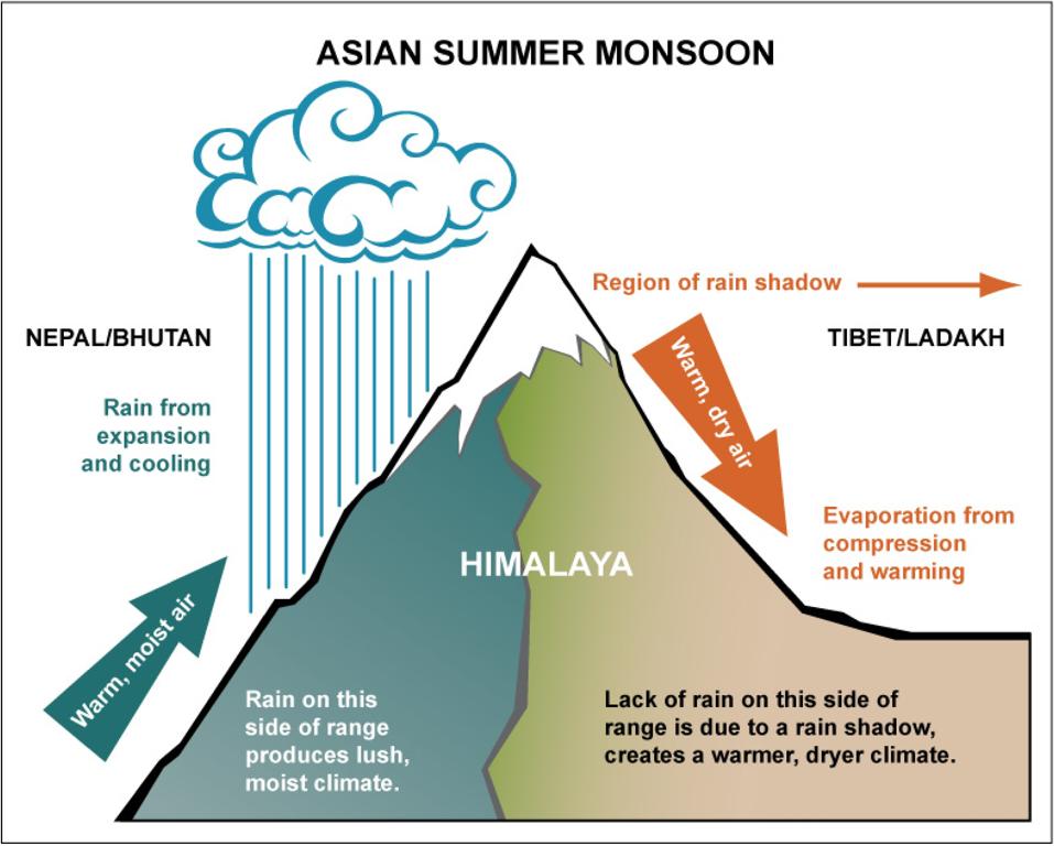
5 II. WEATHER & CLIMATE A. The monsoons dominate the climactic environment & life of much of South Asia. 1. Some of the world s largest annual rainfall totals (over 400 in/yr) are recorded in the Assam hills of northeastern India from the summer rain brought by monsoons winds. (a) Most flooding in the region occurs during the summer. 2. On the Indian peninsula, most of the rain falls on the Western Ghat mountains leaving the eastern lands in a rain shadow. (a) Rain shadow effect - higher rainfall on the windward side of the mountains and lower rainfall on the leeward side of the mountains.
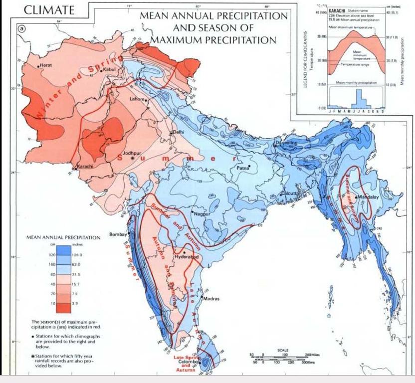
6
7
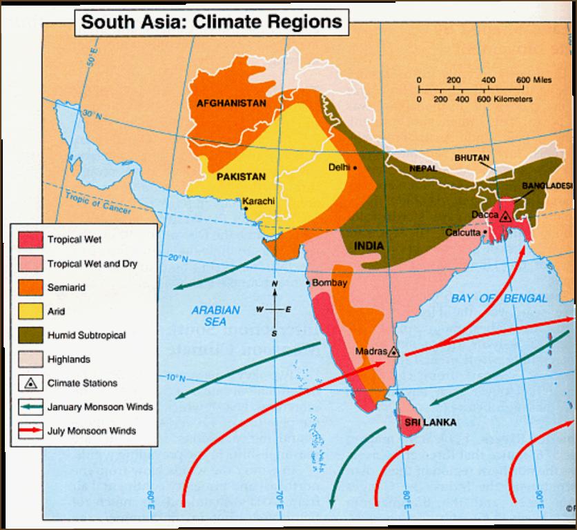
8 B. Regional climate zones 1. Nepal & Bhutan - tundra climate in the north; humid continental in the south 2. India - tropical wet/dry mainly in the northeast & east; humid subtropical in the north; semiarid in the central & northwest 3. Sri Lanka & Maldives - mainly tropical wet 4. Bangladesh - tropical wet/dry 5. Pakistan - mainly semiarid & arid except in extreme northern parts
9
10 III. RESOURCES & THE ENVIRONMENT A. Natural Resources 1. South Asia has many mineral resources such as iron & uranium ore. 2. India has large coal deposits, one of the world s largest reserves. Most of India s demand for electricity come from coal-burning power plants. 3. Timber from boreal forests in Nepal & Bhutan & timber from Sri Lanka & Bangladesh (tropical) also provide a major resource for export.
11 B. Natural Environmental Problems - The people of South Asia face a number of environmental hazards 1. The clashing tectonic plates that produced the Himalayas (Indian plate & Eurasian plate) continue to set off earthquakes, mainly along the base of the Himalayas. (a) The October 2005 Kashmir earthquake measured 7.6 on the Richter scale. It killed 86,000 people & injured more than 69,000 as well as causing widespread destruction of buildings & roads. (earthquake 2013)
12 2. Flooding is a major problem in the lower Ganges & Brahmaputra valleys & their combined delta (Bangladesh). Causes include: (a) snowmelt in the Himalayas combined with heavy rainfall; (b) the funneling effect of the Bay of Bengal & storm surges from cyclones; (c) deforestation in Tibet, Nepal, & Bhutan (increases erosion), & low topography; (d) very highly populated which causes major humanitarian disasters (e) There is very little regional cooperation to reduce this effect.
13 3. Drought is the main problem in other parts of South Asia such as Pakistan. 4. Water shortages raise major social concerns in both rural & urban India. (a) The urban middle classes can install storage tanks for water in times of shortages, but the slum-dwellers wait in line with buckets for water. (b) Members of the upper castes use good wells while the untouchables must find their water elsewhere.
14 5. Tsunamis have caused issues in the past for the coastal regions of India, Sri Lanka, & the Maldives. (a) Example - The Indonesian Tsunami of 2004 killed over 31,000 people in Sri Lanka & over 10,000 in India. (animation)
15 C. Human-Induced Environmental Problems are mainly due to the huge rise in population & the necessary growth in national economies that leave landscapes of exploitation, degraded resources, & pollution 1. The Green Revolution include the use of pesticides & herbicides. The production of these chemicals resulted in toxic concentrations of chemical factories. (a) Example: In 1984, at the Union Carbide pesticide plant in Bhopal, India, water leaked into a methyl isocyanate storage tank, triggering chemical reactions & a cloud of toxic gases. It is considered the world s worst industrial disaster killing over 15,000 people. (Bhopal) 0:00-2:00; (25 years later)
16 2. Air pollution from coal burning power plants & other industry, but not as much acid rain as of yet, but totals have been increasing. The monsoons have kept acid rain at bay. 3. Water pollution (a) In the Ganges - from leather tanning runoff, trash dumping, funeral pyres, despite its sacredness to Hindus. 4. Deforestation is causing erosion & the extinction of wildlife: (a) commercial logging (b) industrial & urban expansion (c) for agricultural land
17 SUMMARIZE - TICKET OUT THE DOOR In your OWN WORDS: What are 3 major environmental problems in South Asia & why? 5-7 sentence paragraph
South, Southeast, and East Asia. Physical Geography
 South, Southeast, and East Asia Physical Geography Mountains v Mountains are important in Asia because they influence: A. Population patterns B. Movement of people and goods C. Climate Mountains v The
The Impact of Geography in South and East Asia
 The Impact of Geography in South and East Asia Gobi desert, Mongolia Essential Question: How does the geography of SE Asia impact trade and the distribution of population throughout the region? (AKS #52a)
The Impact of Geography in South and East Asia
 The Impact of Geography in South and East Asia Gobi desert, Mongolia Essential Question: How does the geography of SE Asia impact trade and the distribution of population throughout the region? (AKS #52a)
The Impact of Geography in South and East Asia
 The Impact of Geography in South and East Asia Gobi desert, Mongolia Essential Question: How does geography impact the distribution of population throughout South and East Asia? I CAN Explain how geography
Chapter 27. Bhutan, Maldives, Nepal, & Sri Lanka
 Chapter 27 Bhutan, Maldives, Nepal, & Sri Lanka Physical Geography of Bhutan, Maldives, Nepal & Sri Lanka Landforms Their locations on the fringe of South Asia means their physical and human geography
Chapter 21 Southwest Asia: Harsh & Arid Lands
 Name Hour Chapter 21 Southwest Asia: Harsh & Arid Lands Essential Question: How has the physical geography of Asia influenced the development of these regions (i.e. history, population distribution, &
Geography Class XI Fundamentals of Physical Geography Section A Total Periods : 140 Total Marks : 70. Periods Topic Subject Matter Geographical Skills
 Geography Class XI Fundamentals of Physical Geography Section A Total Periods : 140 Total Marks : 70 Sr. No. 01 Periods Topic Subject Matter Geographical Skills Nature and Scope Definition, nature, i)
OUR COUNTRY INDIA LOCATIONAL SETTING
 7 India is a country of vast geographical expanse. In the north, it is bound by the lofty Himalayas. The Arabian Sea in the west, the Bay of Bengal in the east and the Indian Ocean in the south, wash the
Tropical Moist Rainforest
 Tropical or Lowlatitude Climates: Controlled by equatorial tropical air masses Tropical Moist Rainforest Rainfall is heavy in all months - more than 250 cm. (100 in.). Common temperatures of 27 C (80 F)
Natural Disasters in Member Countries (2002 Summary)
") 4.2 Member Countries and their Disaster Characteristics: Table 5: Natural Disasters in Member Countries (2002 Summary) (Country/Disaster Type/Disaster Characteristics) Data Country DisType Count of TotAff
4.2 Member Countries and their Disaster Characteristics: Table 5: Natural Disasters in Member Countries (2002 Summary) (Country/Disaster Type/Disaster Characteristics) Data Country DisType Count of TotAff
HOW GEOGRAPHY AND GEOLOGY AFFECT BIOLOGICAL DIVERSITY
 HOW GEOGRAPHY AND GEOLOGY AFFECT BIOLOGICAL DIVERSITY Factors Affecting Extinction Rates Natural Factors Climate change Cataclysmic event (volcano, earthquake) Human Activities Habitat Loss/Fragmentation
Mount Everest and the Gobi Desert
 Mount Everest and the Gobi Desert 1 Mount Everest is part of the mountain chain known as the Himalaya. Adventurers from all over the world come to try to climb it. Mount Everest is the highest mountain
FLOODING. Flood any relatively high stream flow overtopping the natural or artificial banks in a water system.
 CATASTROPHIC EVENTS FLOODING Flood any relatively high stream flow overtopping the natural or artificial banks in a water system. Common Causes: Long-lasting rainfall over a broad area Locally intense
Chapter 27. Bhutan, Maldives, Nepal, & Sri Lanka
 Chapter 27 Bhutan, Maldives, Nepal, & Sri Lanka Physical Geography of Bhutan, Maldives, Nepal & Sri Lanka Landforms Their locations on the fringe of South Asia means their physical and human geography
Report on Disaster statistics of Nepal
 Report on Disaster statistics of Nepal Submitted by Altaf Rehman Submitted to Dr. Naveed Ahmed University of engineering and technology Peshawar Assignment 1 Section A Registration id 14PWCIV456 Page 1
5th social studies geography (5thsocstud_geography)
") Name: Date: 1. Many of the Native Americans who lived on the Great Plains were nomadic people. Why did they move from place to place? A. They were finding new areas to mine. B. They were looking for fertile
Name: Date: 1. Many of the Native Americans who lived on the Great Plains were nomadic people. Why did they move from place to place? A. They were finding new areas to mine. B. They were looking for fertile
SMART NOTES ON INDIAN GEOGRAPHY - 1
 ON INDIAN GEOGRAPHY - 1 Point. Precise. Powerful. www.thesmartnotes.org ON INDIAN GEOGRAPHY - 1 To our Hardworking and persistence aspirants. Success is going from failure to failure without losing enthusiasm.
netw rks Guided Reading Activity Essential Question: How does geography influence the way people live? Earth's Physical Geography
 Guided Reading Activity Lesson 1 Earth and the Sun Essential Question: How does geography influence the way people live? Looking at Earth Directions: What are the layers that make up Earth? Use your textbook
(version 3) I. HumAN -Environment Interaction
 I. HumAN -Environment Interaction") (version 3) I. HumAN -Environment Interaction A. Landforms 1. Earth s topography is made up of many different types of landforms. 2. While the planet is covered primarily with water, the four major types
(version 3) I. HumAN -Environment Interaction A. Landforms 1. Earth s topography is made up of many different types of landforms. 2. While the planet is covered primarily with water, the four major types
Year 4 Geography Revision Pack Summer 2018 Name
 Year 4 Geography Revision Pack Summer 2018 Name Welcome to your geography revision pack for the upcoming Summer exams. Everything that we have been working on in lessons since Christmas will be covered
Biodiversity-Hotspots
 GE 2211 Environmental Science and Engineering Unit II Biodiversity-Hotspots M. Subramanian Assistant Professor Department of Chemical Engineering Sri Sivasubramaniya Nadar College of Engineering Kalavakkam
Chapter 2: Physical Geography
 Chapter 2: Physical Geography Pg. 39-68 Learning Goals for Chp2: q q q q q Explain how the Earth moves in space and why seasons change. Outline the factors that influence climate and recognize different
The peak and southern face of Mount Everest, the tallest mountain on the planet. Photo: Wikimedia Commons.
 Landforms: Mountains By Encyclopaedia Britannica, adapted by Newsela staff on 10.10.17 Word Count 563 Level 800L The peak and southern face of Mount Everest, the tallest mountain on the planet. Photo:
*X208/11/01* X208/11/01 GEOGRAPHY INTERMEDIATE 2 NATIONAL QUALIFICATIONS 2014 THURSDAY, 29 MAY 9.00 AM AM
 X208/11/01 NATIONAL QUALIFICATIONS 2014 THURSDAY, 29 MAY 9.00 AM 11.00 AM GEOGRAPHY INTERMEDIATE 2 Candidates should answer four questions: Section A Question 1 and Question 2 AND Section B any two questions
CH. 3: Climate and Vegetation
 CH. 3: Climate and Vegetation GROUP WORK RUBRIC Score of 50 (5): Superior - 100% A 5 is superior work, and has completed all requirements of the assignments, it is in order and its presentation is almost
The structure of the Earth and how its motion creates the seasons. The landforms of the earth and the forces that shape the land.
 The structure of the Earth and how its motion creates the seasons. The landforms of the earth and the forces that shape the land. The role of wind and water in creating climate. The different climate and
2. PHYSICAL FEATURES OF INDIA
 2. PHYSICAL FEATURES OF INDIA Question 1: Choose the right answer from the four alternatives given below. (i) A landmass bound by sea on three sides is referred to as (a) Coast (c) Peninsula (b) Island
Physical Geography of the United States and Canada Chapter 5 A Land of Contrasts
 Physical Geography of the United States and Canada Chapter 5 A Land of Contrasts Land Area Together the U.S. and Canada cover more than 7 million square miles. In total area, Canada ranks 2 nd and the
Tropical Climates Zone
 Tropical Climates Zone RAIN FOREST CENTRAL AFRICA, SOUTH AMERICA (AMAZON), CENTRAL AMERICA, S.E. ASIA HUMID/WARM ANNUAL RAINFALL 200 CM TYPE #1: TROPICAL DESERT N. AFRICA (SAHARA) & S.W. ASIA < 25 CM
GLOBAL CLIMATES FOCUS
 which you will learn more about in Chapter 6. Refer to the climate map and chart on pages 28-29 as you read the rest of this chapter. FOCUS GLOBAL CLIMATES What are the major influences on climate? Where
Fukien Secondary School Monthly Vocabulary/Expression List for EMI Subjects Secondary Two. Subject: Geography
 Focus: General Specific : Section Two : Unit One 1 Landslide 2 Downslope movement 3 Rock 4 Soil 5 Gravity 6 Natural hazard 7 Rainwater 8 Friction 9 Hilly relief 10 Unstable 11 Season 12 Saturated 13 Construction
Physical Geography of East Asia
 Physical Geography of East Asia Satellite View of China Landforms of China China s Geography China Miles 0 250 500 1,000 1,500 2,000 United States 3 rd largest country in the world. Comparable to the US
Spring break reading. Glacial formation. Surface processes: Glaciers and deserts. The Control of Nature
 suggested Spring break reading The Control of Nature by John McPhee Surface processes: Glaciers and deserts describes our efforts to control three natural hazards: 1. The Mississippi Floods 2. The Heimaey
Term Knowledge Using and applying Grade Criteria Autumn 1 Assessment window October Natural hazards pose major risks to people and property.
 Assessment Schedule Year 9 2015/6 Term Knowledge Using and applying Grade Criteria Autumn 1 Assessment window October 2015 3.1.1.2 Tectonic Natural hazards pose major risks to people and property. Definition
Weather Atmospheric condition in one place during a limited period of time Climate Weather patterns that an area typically experiences over a long
 Weather Atmospheric condition in one place during a limited period of time Climate Weather patterns that an area typically experiences over a long period of time Many factors influence weather & climate
Chapter 1 Section 2. Land, Water, and Climate
 Chapter 1 Section 2 Land, Water, and Climate Vocabulary 1. Landforms- natural features of the Earth s land surface 2. Elevation- height above sea level 3. Relief- changes in height 4. Core- most inner
Which map shows the stream drainage pattern that most likely formed on the surface of this volcano? A) B)
 B)") 1. When snow cover on the land melts, the water will most likely become surface runoff if the land surface is A) frozen B) porous C) grass covered D) unconsolidated gravel Base your answers to questions
1. When snow cover on the land melts, the water will most likely become surface runoff if the land surface is A) frozen B) porous C) grass covered D) unconsolidated gravel Base your answers to questions
CHAPTER 12 NATURAL DISASTERS
 CHAPTER 12 NATURAL DISASTERS In this chapter, you learn about the following: Natural calamities cyclones causes, effects and preventive measures Floods causes, affected areas, effects and control Land
East Asia. Mongolia, China, Taiwan, the Koreas, and Japan
 East Asia Mongolia, China, Taiwan, the Koreas, and Japan Major Geographic Characteristics of East Asia East Asia is the most populous region in the world China is the most populous country, and the oldest
Chapter 2 Planet Earth
 Chapter 2 Planet Earth Section Notes Earth and the Sun s Energy Water on Earth The Land Close-up The Water Cycle World Almanac Major Eruptions in the Ring of Fire Quick Facts Chapter 2 Visual Summary Video
THE EARTH S RELIEF SOCIAL SCIENCES 1º ESO
 THE EARTH S RELIEF SOCIAL SCIENCES 1º ESO 1. THE STRUCTURE OF THE EARTH The Earth is divided into layers: The crust is the surface layer. It is a thin, solid layer made of rock. The Earth s crust has a
Long-Term Trend of Summer Rainfall at Selected Stations in the Republic of Korea
 Long-Term Trend of Summer Rainfall at Selected Stations in the Republic of Korea Il-Kon Kim Professor, Department of Region Information Rafique Ahmed Professor, Geography and Earth Science Silla University
Conceptual Understandings for K-2 Teachers
 AFK12SE/NGSS Strand Disciplinary Core Ideas ESS1: Earth s Place in the Universe What is the universe, and what is Earth s place in it? ESS1. A: The Universe and Its Stars What is the universe, and what
Social Studies. Chapter 2 Canada s Physical Landscape
 Social Studies Chapter 2 Canada s Physical Landscape Introduction Canada s geography its landforms and climate - has a great impact on Canadians sense of identity. Planet Earth The earth is divided into
INDIAN SCHOOL MUSCAT SENIOR SECTION DEPARTMENT OF SOCIAL SCIENCE CLASS: IX : GEOGRAPHY TOPIC/CHAPTER: CHAPTER: 2 PHYSICAL FEATURES
 INDIAN SCHOOL MUSCAT SENIOR SECTION DEPARTMENT OF SOCIAL SCIENCE CLASS: IX : GEOGRAPHY TOPIC/CHAPTER: CHAPTER: 2 PHYSICAL FEATURES WORKSHEET NO. 06 Summary:- Tectonic Plate Theory:- This theory is based
Geographical location and climatic condition of the
 Geographical location and climatic condition of the study sites North eastern region of India is comprised of eight states namely; Arunachal Pradesh, Assam, Manipur, Meghalaya, Mizoram, Nagaland, Sikkim
Natural Vegetation and Wildlife
 Natural Vegetation and Wildlife Exercise Page 51 Question 1: Choose the right answer from the four alternatives given below. (i) To which one of the following types of vegetation does rubber belong? (a)
WHAT IS THE EARTH MADE OF? LITHOSPHERE AND HYDROSPHERE
 UNIT 8 WHAT IS THE EARTH MADE OF? LITHOSPHERE AND HYDROSPHERE TABLE OF CONTENTS 1 THE STRUCTURE OF THE EARTH... 2 2 THE FORMATION OF THE RELIEF: INTERNAL AND EXTERNAL FORCES.... 2 2.1 Internal forces:
GEOGRAPHY. In relation to the above aims, candidates should, after completing this syllabus, be able to
 GEOGRAPHY AIMS The aims of this syllabus are to enable candidates 1. to recognize and understand the arrangement of phenomena and features on Earth as well as the inter-relationship and interaction among
Weather Atmospheric condition in one place during a limited period of time Climate Weather patterns that an area typically experiences over a long
 Weather Atmospheric condition in one place during a limited period of time Climate Weather patterns that an area typically experiences over a long period of time Many factors influence weather & climate
STAAR Science Tutorial 48 TEK 8.11C: Effects of Environmental Change
 Name: Teacher: Pd. Date: STAAR Science Tutorial 48 TEK 8.11C: Effects of Environmental Change TEK 8.11C: Explore how short- and long-term environmental changes affect organisms and traits in subsequent
Summative Assessment I
 Class: IV Time: 3 Hrs. Summative Assessment I Social Science Marks: 88 Handwriting: 2 Total: 90 1. All questions are compulsory. 2. Use crayons for colouring. General Instruction I. Multiple choice questions:
Unit 7.2 W.E.D. & Topography Test
 Name: Score: Unit 7.2 W.E.D. & Topography Test 1. 2. 3. 4. 5. 6. 7. 8. 9. 10. 11. 12. 13. 14. 15. 16. 17. 18. 19. 20. 21. 22. 23. 24. 25. 1. The formation of mountains is due mainly to while the destruction
Exploring the Geography of West Asia
 Unit 3 - Lesson 1 Content Expectations 7 G1.1.1: Explain and use a variety of maps, globes, and web based geography technology to study the world, including global, interregional, regional, and local scales.
Bell Work. REVIEW: Our Planet Earth Page 29 Document A & B Questions
 9.12.16 Bell Work REVIEW: Our Planet Earth Page 29 Document A & B Questions Intro to Climate & Weather https://www.youtube.com/watch?v=vhgyoa70q7y Weather vs. Climate Video Climate & Weather 3.1 Weather
Weather and Climate. Weather the condition of the Earth s atmosphere at a particular time and place
 Weather and Climate Weather the condition of the Earth s atmosphere at a particular time and place Climate the average year-after-year conditions of temperature, precipitation, winds and clouds in an area
3. The map below shows an eastern portion of North America. Points A and B represent locations on the eastern shoreline.
 1. Most tornadoes in the Northern Hemisphere are best described as violently rotating columns of air surrounded by A) clockwise surface winds moving toward the columns B) clockwise surface winds moving
GEOGRAPHY (029) CLASS XI ( ) Part A: Fundamentals of Physical Geography. Map and Diagram 5. Part B India-Physical Environment 35 Marks
 CLASS XI ( ) Part A: Fundamentals of Physical Geography. Map and Diagram 5. Part B India-Physical Environment 35 Marks") GEOGRAPHY (029) CLASS XI (207-8) One Theory Paper 70 Marks 3 Hours Part A Fundamentals of Physical Geography 35 Marks Unit-: Geography as a discipline Unit-3: Landforms Unit-4: Climate Unit-5: Water (Oceans)
GEOGRAPHY (029) CLASS XI (207-8) One Theory Paper 70 Marks 3 Hours Part A Fundamentals of Physical Geography 35 Marks Unit-: Geography as a discipline Unit-3: Landforms Unit-4: Climate Unit-5: Water (Oceans)
Impact of Atmoshpheric Brown Clouds (ABCs) on Agriculture. Dr.A.K.Gogoi, ADG(Agro) ICAR, New Delhi- 12
 on Agriculture. Dr.A.K.Gogoi, ADG(Agro) ICAR, New Delhi- 12") Impact of Atmoshpheric Brown Clouds (ABCs) on Agriculture Dr.A.K.Gogoi, ADG(Agro) ICAR, New Delhi- 12 What are ABCs Atmospheric Brown Clouds (ABC s ) are regional scale slums of air pollution that consists
Impact of Atmoshpheric Brown Clouds (ABCs) on Agriculture Dr.A.K.Gogoi, ADG(Agro) ICAR, New Delhi- 12 What are ABCs Atmospheric Brown Clouds (ABC s ) are regional scale slums of air pollution that consists
Restless Earth Margin type Description Features Hazard
 Unit 1 Revision Restless Earth 1. Structure of the earth Using the textbook complete the following statements: - Continental crust is than oceanic crust. - Oceanic crust is more than continental crust
Paper Reference. Paper Reference(s) 1312/4H Edexcel GCSE Geography A Higher Tier. Monday 11 June 2007 Afternoon Time: 1 hour 15 minutes
 1312/4H Edexcel GCSE Geography A Higher Tier. Monday 11 June 2007 Afternoon Time: 1 hour 15 minutes") Centre No. Paper Reference Surname Initial(s) Candidate No. 1 3 1 2 4 H Signature Paper Reference(s) 1312/4H Edexcel GCSE Geography A Higher Tier Paper 4H Monday 11 June 2007 Afternoon Time: 1 hour 15
Centre No. Paper Reference Surname Initial(s) Candidate No. 1 3 1 2 4 H Signature Paper Reference(s) 1312/4H Edexcel GCSE Geography A Higher Tier Paper 4H Monday 11 June 2007 Afternoon Time: 1 hour 15
Multiple Choice Identify the choice that best completes the statement or answers the question.
 CH.15 practice TEST Multiple Choice Identify the choice that best completes the statement or answers the question. 1) The short-term state of the atmosphere is called a) climate. c) water cycle. b) weather.
Chapter 6, Part Colonizers arriving in North America found extremely landscapes. It looked different to region showing great.
 Social Studies 9 Unit 1 Worksheet Chapter 6, Part 1. 1. Colonizers arriving in North America found extremely landscapes. It looked different to region showing great. 2. The Earth is years old and is composed
Queensland Floods- Part A
 Queensland Floods- Part A Floods Flooding is when the water level in a creek, river, lake or the sea rises and covers land that is normally dry. The rise in water can be due to numerous causes, although
Unit 2: The World in Spatial Terms (Lessons 6-7)
") Unit 2: The World in Spatial Terms (Lessons 6-7) Physical Features of Earth Create Challenges and Opportunities The physical features of Earth create both challenges and opportunities for the people living
Unit 2: The World in Spatial Terms (Lessons 6-7) Physical Features of Earth Create Challenges and Opportunities The physical features of Earth create both challenges and opportunities for the people living
EFFECTIVE TROPICAL CYCLONE WARNING IN BANGLADESH
 Country Report of Bangladesh On EFFECTIVE TROPICAL CYCLONE WARNING IN BANGLADESH Presented At JMA/WMO WORKSHOP ON EFFECTIVE TROPICAL CYCLONE WARNING IN SOUTHEAST ASIA Tokyo, Japan,11-14 March 2014 By Sayeed
Chapter 2 Earth s Interlocking Systems pg The Earth and Its Forces pg
 Chapter 2 Earth s Interlocking Systems pg. 24 55 2 1 The Earth and Its Forces pg. 27 33 Connecting to Your World and Internal Forces Shaping the Earth The Earth is unique in the solar system because it
Level 1/Level 2 Certificate Specimen Paper
 Centre Number Surname Other Names Candidate Number For Examiner s Use Examiner s Initials Candidate Signature Geography 8031/1 Dynamic Physical World For this paper you must have: the colour insert (enclosed).
Unit 2. United States Physical Geography
 Unit 2 United States Physical Geography Physical Geography U.S. extends from the Atlantic to Pacific U.S. is the 3rd largest country U.S. has fertile soils, vast forests, and variety of minerals All major
Atlases. About Chapter 2. Chapter II: Earth in Space
 Chapter 2: Earth in Space Class Workbooks Each chapter will have a mapping section You will receive a class workbook to KEEP You need to take this to class when it is announced the day before if you forget
The Earth, the sun, the planets and the twinkling stars in the sky are all part of a galaxy, or family of stars. We call our galaxy the Milky Way
 Part One The Earth, the sun, the planets and the twinkling stars in the sky are all part of a galaxy, or family of stars. We call our galaxy the Milky Way because the lights from its billions of stars
Landscape evolution. An Anthropic landscape is the landscape modified by humans for their activities and life
 Landforms Landscape evolution A Natural landscape is the original landscape that exists before it is acted upon by human culture. An Anthropic landscape is the landscape modified by humans for their activities
Climate and the Atmosphere
 Climate and Biomes Climate Objectives: Understand how weather is affected by: 1. Variations in the amount of incoming solar radiation 2. The earth s annual path around the sun 3. The earth s daily rotation
Give me one example of: Benthos. Diagram Upwelling. Explain a Convection Cell. What does it mean to have a high albedo?
 The surface will reflect a lot of the sun s radiation. What does it mean to have a high albedo? Warmer, less dense materials rise while cooler more dense materials sink. Explain a Convection Cell What
Climate & Climate Change in Indus Basin. How Can Research Help? Danial Hashmi, Pakistan
 Climate & Climate Change in Indus Basin How Can Research Help? Danial Hashmi, Pakistan Sequence of Presentation Brief Description of Indus Basin Climate of Indus Basin Climate of Upper Indus Basin Climate
I CAN DO sheets Southchurch High School
 Rate your confidence in the following topic content and geographical skills by ticking the appropriate column beside each point: Red = Not confident Yellow = Almost there Green = Confident Changing landscapes
Global Atmospheric Circulation. Past climate change and natural causes. Global climate change and human activity
 GCSE Geography Edexcel B Revision Checklist Paper 1. Global Geographical Issues Topic 1. Hazardous Earth Key Idea I know/ understand The world s climate system Global Atmospheric Circulation Past climate
GIRLS SECON DARY - MRIEĦEL HALF-YEARLY EXAMINATIONS 2016/2017
 GIRLS SECON DARY - MRIEĦEL HALF-YEARLY EXAMINATIONS 2016/2017 FORM: 4 Time: 1 ½ hrs Name: Class: Section A: Weather and Climate 1. Place the following weather conditions under the appropriate heading.
Website Lecture 4 The Physical Environment Continued
 Website http://websites.rcc.edu/halama Lecture 4 The Physical Environment Continued 1 Lecture 4 1. Weather and Climate Global Local 2. Internal Planetary Processes Layers Plate Tectonics Earthquakes Volcanos
Year 7 Geography. ü BBC Bitesize: Map and Atlas Skills https://www.bbc.com/education/topics/zm38q6f
 Year 7 Year 7 Geography ü Mapping and map skills (continents, compass directions, grid references) ü Tourism in the UK ü Rivers (Water cycle, river landforms) ü Population (push and pull factors, population
Geography Exams. RAG rate The Challenge of Natural Hazards
 Geography Exams You will sit three papers, Paper 1 will last 1 hour 30 minutes and will examine your understanding of The Challenge of Natural Hazards, The Living World and Physical Landscapes in the UK.
Advanced Hydrology. (Web course)
") Advanced Hydrology (Web course) Subhankar Karmakar Assistant Professor Centre for Environmental Science and Engineering (CESE) Indian Institute of Technology Bombay Powai, Mumbai 400 076 Email: skarmakar@iitb.ac.in
Advanced Hydrology (Web course) Subhankar Karmakar Assistant Professor Centre for Environmental Science and Engineering (CESE) Indian Institute of Technology Bombay Powai, Mumbai 400 076 Email: skarmakar@iitb.ac.in
School Program Name: Name of Sanctuary: Grade Level: Grades 6 8 Location Options: Time:
 School Program Name: Name of Sanctuary: Grade Level: Grades 6 8 Location Options: Time: For more info: Landforms of New England Moose Hill Wildlife Sanctuary At the sanctuary 2 hours or combine with another
Từ vựng IELTS 5+ - Geography and Geology
 Từ vựng IELTS 5+ - Geography and Geology 1 I. VOCAB Topography (təˈpɒɡ.rə.fi): the physical appearance of the natural features of an area of land, especially the shape of its surface. Surroundings (səˈraʊn.dɪŋz):
What is the largest country in the world? Russia
 What is the largest country in the world? #1 Russia CSCOPE 2007 2 Russia Dimensions #2-3 Spans 11 Time Zones From East to West: Gulf of Finland to Alaska From North to South: Above the Arctic Circle to
3/3/2013. The hydro cycle water returns from the sea. All "toilet to tap." Introduction to Environmental Geology, 5e
 Introduction to Environmental Geology, 5e Running Water: summary in haiku form Edward A. Keller Chapter 9 Rivers and Flooding Lecture Presentation prepared by X. Mara Chen, Salisbury University The hydro
PALEOGEOGRAPHY of NYS. Definitions GEOLOGIC PROCESSES. Faulting. Folding 9/6/2012. TOPOGRAPHIC RELIEF MAP of NYS GRADATIONAL TECTONIC
 TOPOGRAPHIC RELIEF MAP of NYS PALEOGEOGRAPHY of NYS Prof. Anthony Grande AFG 2012 Definitions GEOLOGIC PROCESSES Geography: study of people living on the surface of the earth. Geology: the scientific study
Section 11.1 pp Where Mountains Form
 Section 11.1 pp. 236 237 Where Mountains Form Chapter 11 Set a Purpose: TE, p. 236 Reading Study Guide, p. 36 Discussion: TE, p. 236 Differentiating ion Reading Support: TE, p. 236 Visual Teaching Interpret
Name Date Class. well as the inland, found near the Tropics. 4. In the, or the regions near the Equator, you may find a lush
 WATER, CLIMATE, AND VEGETATION Vocabulary Activity DIRECTIONS: Fill in the Blanks Select a term from below to complete each of the following sentences. CHAPTER 1. The constant movement of water, a process
Paper Reference. Paper Reference(s) 1312/2F Edexcel GCSE Geography A Foundation Tier. Monday 11 June 2007 Afternoon Time: 1 hour 15 minutes
 1312/2F Edexcel GCSE Geography A Foundation Tier. Monday 11 June 2007 Afternoon Time: 1 hour 15 minutes") Centre No. Paper Reference Surname Initial(s) Candidate No. 1 3 1 2 2 F Signature Paper Reference(s) 1312/2F Edexcel GCSE Geography A Foundation Tier Paper 2F Monday 11 June 2007 Afternoon Time: 1 hour
Centre No. Paper Reference Surname Initial(s) Candidate No. 1 3 1 2 2 F Signature Paper Reference(s) 1312/2F Edexcel GCSE Geography A Foundation Tier Paper 2F Monday 11 June 2007 Afternoon Time: 1 hour
Physical Geography: Patterns, Processes, and Interactions, Grade 11, University/College Expectations
 Geographic Foundations: Space and Systems SSV.01 explain major theories of the origin and internal structure of the earth; Page 1 SSV.02 demonstrate an understanding of the principal features of the earth
Candidate Name Centre Number Candidate Number CHANGING PHYSICAL AND HUMAN LANDSCAPES SAMPLE ASSESSMENT MATERIALS
 GCSE GEOGRAPHY Sample Assessment Materials 5 Candidate Name Centre Number Candidate Number 0 GCSE GEOGRAPHY UNIT 1 CHANGING PHYSICAL AND HUMAN LANDSCAPES SAMPLE ASSESSMENT MATERIALS 1 hour 30 minutes Section
GEOGRAPHY. H.C.G. - Paper 2
 CLASS IX GEOGRAPHY H.C.G. - Paper 2 (Two hours) Answers to this Paper must be written on the answer sheet provided separately. You will not be allowed to write during the first 15 minutes. This time is
Catastrophic Events Impact on Ecosystems
 Catastrophic Events Impact on Ecosystems Hurricanes Hurricanes An intense, rotating oceanic weather system with sustained winds of at least 74 mph and a welldefined eye Conditions for formation: Warm water
Dawood Public School Secondary Section Class VII
 Dawood Public School Secondary Section Class VII Introduction: Geography is the study of the Earth and its lands, features, inhabitants, and phenomena relating to the sciences of aforementioned. This subject
World Geography Chapter 3
 World Geography Chapter 3 Section 1 A. Introduction a. Weather b. Climate c. Both weather and climate are influenced by i. direct sunlight. ii. iii. iv. the features of the earth s surface. B. The Greenhouse
Impacts of Climate Change and Water-Related Disaster Reduction Management in the Asia-Pacific Region
 Impacts of Climate Change and Water-Related Disaster Reduction Management in the Asia-Pacific Region Katumi MUSIAKE Professor, Fukushima University Secretary General, Asia Pacific Association of Hydrology
Sec$on 1: Geography and Early China. How does China s geography affect the culture?
 Sec$on 1: Geography and Early China How does China s geography affect the culture? Con$nents of the World Label the continents. Where is China located? Where is China located? In your groups, begin filling
iv vi x Using maps 2 Using images and analysing data 6 Using new technologies in geography 8
 Contents Exam board specification map Introduction Topic checker iv vi x Geographical skills Using maps 2 Using images and analysing data 6 Using new technologies in geography 8 Natural hazards Tectonic
Weathering and Erosion Board Game Directions
 Weathering and Erosion Board Game Directions 1. Divide the class into teams of three. Two of the groups will be the players and one will hold the answer sheet and tell players if answers are correct or