The Impact of Geography in South and East Asia
|
|
|
- Norah McCormick
- 5 years ago
- Views:
Transcription

1 The Impact of Geography in South and East Asia
2 Gobi desert, Mongolia Essential Question: How does the geography of SE Asia impact trade and the distribution of population throughout the region? (AKS #52a)
3 I CAN Explain how the mountains of South and East Asia impact trade and affect where people live. Explain how the deserts of South and East Asia impact trade and affect where people live. Explain how the river systems of South and East Asia impact trade and affect where people live.

4 Over 66% of the world s population lives in this circle.


5 The Himalaya Mountains are the tallest mountain chain in the world and isolate India from other countries in Asia. The region is cold and has little vegetation, making it difficult to inhabit. Few people live within the boundaries of the Himalayas because the mountainous landscape makes the land difficult to farm and form a boundary to trade, limiting the amount of food and other goods to be brought to the people who live there.

6 Himalayan Mountains The Himalayan Mountains have acted as a natural barrier for the subcontinent, protecting it from invaders over the centuries. They also act as a barrier for weather patterns.

7 Mt. Everest tallest peak in the world!!
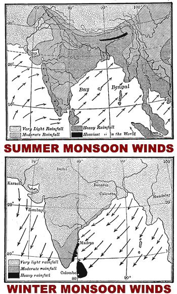
8 Monsoons Southeast Asia s climate is dominated by monsoons. Monsoons are strong, seasonal winds. Monsoons blow from the land toward the sea in winter, and from the sea toward land in the summer. Which season gets more rain?
9
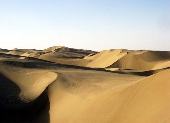
10 The Impact of Mountains The Himalayas block cold air from getting to India and block the Indian rains from the north. As a result, the Gobi and Taklimakan Deserts are north of the Himalayan Mountains.

11 Gobi desert, Mongolia Gobi Desert


12 Gobi desert, Mongolia Gobi Desert

13 Gobi desert, Mongolia Gobi Desert

14 Gobi desert, Mongolia Taklimakan Desert

15 Gobi desert, Mongolia Taklimakan Desert
16

17 Gobi desert, Mongolia Taklimakan Desert
18
19 Why is the population density of this area so small? This part of Asia has an extremely cold and harsh environment.

20 GIST Challenge Capture the main ideas from this section of your Interactive Notes and create a GIST summarizing how mountains in SE Asia impact the distribution of population throughout the region. You must paraphrase the information we just discussed in your own words and in a complete sentence. Your GIST must not exceed 12 words! Write your summary statement in the blank spaces provided for you on your graphic organizer. Be prepared to share!

21 Geography of the Indian subcontinent South Asia includes the countries of India and Pakistan, as well as Bangladesh, Nepal, Bhutan, and Sri Lanka. The region is a subcontinent, a large landmass that is isolated from the rest of the continent. The subcontinent has two major rivers, the Indus and the Ganges. People on the subcontinent depend on the rivers for drinking, irrigation, transportation, trade, and power.

22 Rivers of the Indian subcontinent: Indus and Ganges

23 Ganges River System flows through India Bangladesh and

24 Ganges River It is sacred to Hindus.

25 Ganges River polluted by human, animal, and industrial waste
26 Most of India s people live along the Ganges River in the northern part of the country. It is not only an important water source, but also has religious significance.

27 China s geography 2/3 of China is desert or mountains. This leaves only 10% of the land suitable for farming.

28 North China Plain China s richest farmland
29 Farming is widespread in the fertile river valleys, plains & plateau areas where there is plenty of rainfall.
30
31 Most Chinese live in the east and southeast.

32 Rivers of China: Huang He & Yangtze

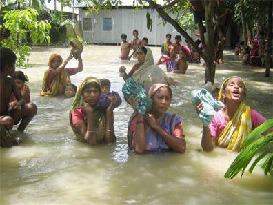
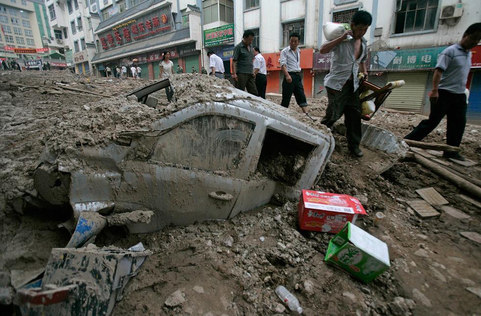
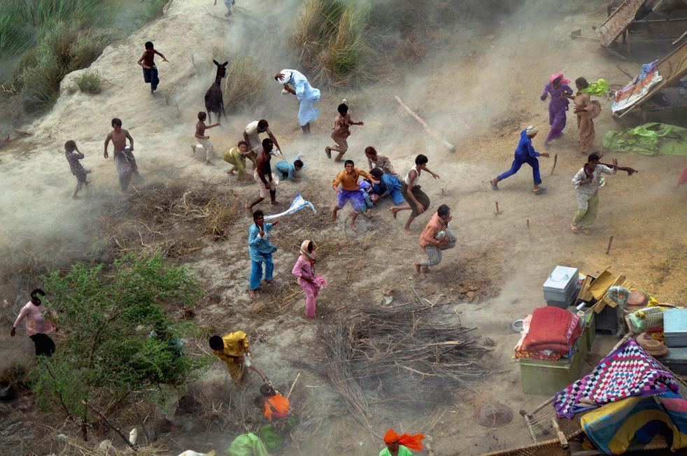
33 Ordos Desert North China Plain Yellow River system Huang He Yellow River

34 Middle Reaches of the Yellow River Yellow River full of fertile loess (silt)

35 What Loess Looks Like

36 The Silt-Choked Yellow River

37 Tibetan Plateau Yangtze Gorges Dongting Lake Poyang Lake Yangtze River system Yangtze River

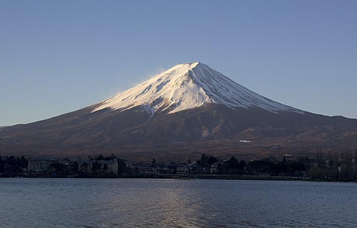
38 Yangtze River Gorges, Sichuan province Yangtze River aka Chiang Jiang or Long River

39 Yangtze River Gorges, Sichuan province Yangtze River aka Chiang Jiang or Long River
40 Flooding in Asia The Huang He has two nicknames, reflecting the impact of flooding. It is known as the Yellow River, because flooding brings loess for fertile farmland. It is also known as China s Sorrow, because flooding has killed millions of Chinese throughout the centuries.
41
42
43
44 Gobi desert, Mongolia Essential Question: How does the geography of SE Asia impact trade and the distribution of population throughout the region? (AKS #52a)
45 Japan s Geography Comprised of four large islands named Honshu, Hokkaido, Kyushu, and Shikoku, and many smaller islands. Japan is an archipelago, a chain of islands that form a country. About 3/4 of Japan's land surface is mountainous.
46 Mt. FUJI


47 Due to Japan s mountainous terrain, most of the people are concentrated along coastlines where the largest cities are located.

48 Gobi desert, Mongolia Personal Space? What s personal space?

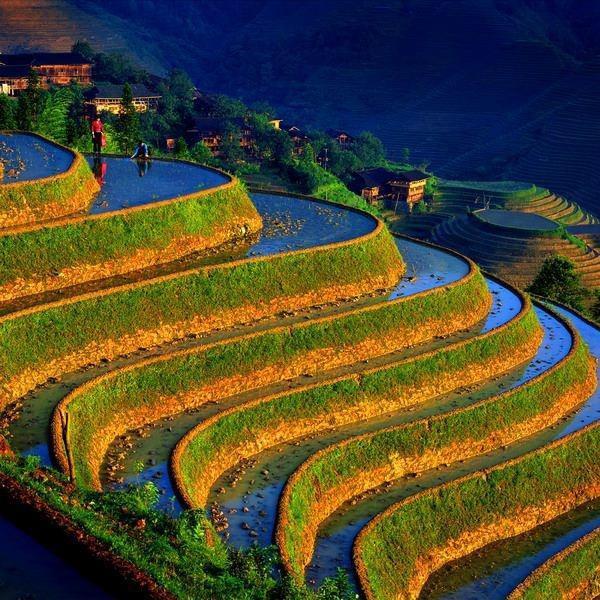
49 Gobi desert, Mongolia A nice, relaxing day at the pool?

50 Gobi desert, Mongolia Capsule Hotel
51 GIST Challenge Capture the main ideas from this section of your Interactive Notes and create a GIST summarizing the impact Japan s geography has on the distribution of population. You must paraphrase the information we just discussed in your own words and in a complete sentence. Your GIST must not exceed 12 words! Write your summary statement in the blank spaces provided for you on your graphic organizer. Be prepared to share!

52 Trade in se asia How does location and geography influence what people do in SE Asia?
53 Trade in se asia The majority of Asians live in rural areas, farming the land to provide food for their families. However, there are also many highly populated urban areas where Asians can work in industry, technology, and service industries.


54 Trade in SE ASIA India has large cities with massive populations that are located near manufacturing areas. Mumbai Kolkata (Calcutta)

55 Trade in SE ASIA Major Chinese cities like Beijing, Shanghai, and Hong Kong are located near manufacturing areas.
56 Agriculture Many people in Asia work in agriculture to produce enough food for the increasing population. Mountains in Asia limit the amount of available farmland. Asia has many mouths to feed, so they must find ways to create more farmland by building terraces. Terraces are steps cut into hillsides that allow more land to be farmed.

57 Rice Terraces, terraces, South South China China

58
59
60 Agriculture In Japan, many people also work in the fishing industry. Japan depends on imports for much of its food.
61 GIST Challenge Capture the main ideas from this section of your Interactive Notes and create a GIST summarizing the impact South and East Asia s geography has on trade. You must paraphrase the information we just discussed in your own words and in a complete sentence. Your GIST must not exceed 12 words! Write your summary statement in the blank spaces provided for you on your graphic organizer. Be prepared to share!
62 Label page 108 of your Interactive Notebook with the following: Today s EQ: How does the geography of SE Asia impact trade and the distribution of population throughout the region? (AKS #52a) Title of this task


63 As you travel around town or across the country, you can see historical markers, or signs that describe the why that particular location is so important. Here are some examples:
64 Your Task: On page 108 of your Interactive Notebook, you will create a historical marker that would be posted at one of the geographic locations we learned about today that explains the impact that particular location has on the distribution of population and trade in that part of South and East Asia. (*Look on page 107 of your INB!*) Your marker MUST have the following: A title A colorful illustration representing the place. A paragraph (5-7 complete sentences) explaining in your own words the impact that location has on population distribution and trade in that part of Asia.

65 In 5-7 complete sentences, you will explain the impact that particular location has on the distribution of population and trade in that part of South and East Asia.
The Impact of Geography in South and East Asia
 The Impact of Geography in South and East Asia Gobi desert, Mongolia Essential Question: How does the geography of SE Asia impact trade and the distribution of population throughout the region? (AKS #52a)
The Impact of Geography in South and East Asia
 The Impact of Geography in South and East Asia Gobi desert, Mongolia Essential Question: How does geography impact the distribution of population throughout South and East Asia? I CAN Explain how geography
South, Southeast, and East Asia. Physical Geography
 South, Southeast, and East Asia Physical Geography Mountains v Mountains are important in Asia because they influence: A. Population patterns B. Movement of people and goods C. Climate Mountains v The
Sec$on 1: Geography and Early China. How does China s geography affect the culture?
 Sec$on 1: Geography and Early China How does China s geography affect the culture? Con$nents of the World Label the continents. Where is China located? Where is China located? In your groups, begin filling
Chapter 21 Southwest Asia: Harsh & Arid Lands
 Name Hour Chapter 21 Southwest Asia: Harsh & Arid Lands Essential Question: How has the physical geography of Asia influenced the development of these regions (i.e. history, population distribution, &
Physical Geography of East Asia
 Physical Geography of East Asia Satellite View of China Landforms of China China s Geography China Miles 0 250 500 1,000 1,500 2,000 United States 3 rd largest country in the world. Comparable to the US
Ancient China UNIT 4 GEOGRAPHY CHALLENGE. 1 Unit 4 Geography Challenge. Teachers Curriculum Institute
 UNIT 4 GEOGRAPHY CHALLENGE Ancient China N W E S 0 250 500 miles 0 250 500 kilometers Albers Conic Equal-Area Projection AW_ISN_U04_01 Ancient China Second Proof TCI18 108 1 Unit 4 Geography Challenge
Ancient China. Teachers Curriculum Institute Geography and the Early Settlement of China 1. AW_ISN_U04_01 Ancient China Second Proof TCI18 108
 G e o g r a p h y C h a l l e n g e Ancient China N W E S 0 250 500 miles 0 250 500 kilometers Albers Conic Equal-Area Projection AW_ISN_U04_01 Ancient China Second Proof TCI18 108 Teachers Curriculum
UNIT 11 SOUTH ASIA SG 1 - PHYSICAL GEOGRAPHY & THE ENVIRONMENT
 UNIT 11 SOUTH ASIA SG 1 - PHYSICAL GEOGRAPHY & THE ENVIRONMENT I. PHYSICAL GEOGRAPHY TAKE OUT YOUR PHYSICAL MAP OF SOUTH ASIA A. The Himalayan Mountains form the northern boundary of the region (color
Mount Everest and the Gobi Desert
 Mount Everest and the Gobi Desert 1 Mount Everest is part of the mountain chain known as the Himalaya. Adventurers from all over the world come to try to climb it. Mount Everest is the highest mountain
East Asia. Mongolia, China, Taiwan, the Koreas, and Japan
 East Asia Mongolia, China, Taiwan, the Koreas, and Japan Major Geographic Characteristics of East Asia East Asia is the most populous region in the world China is the most populous country, and the oldest
Chapter 27. Bhutan, Maldives, Nepal, & Sri Lanka
 Chapter 27 Bhutan, Maldives, Nepal, & Sri Lanka Physical Geography of Bhutan, Maldives, Nepal & Sri Lanka Landforms Their locations on the fringe of South Asia means their physical and human geography
September 14, 2013 Objective: How does geography impact history? What important features exist that have shaped societies?
 Lowenhaupt 1 September 14, 2013 Objective: How does geography impact history? What important features exist that have shaped societies? Warm-Up: In your binder, answer the following question: Imagine you
Physical Geography. Ariel view of the Amazon Rainforest. A Look at the Seven Continents
 Physical Geography In this unit you will learn about general physical geography. The study of the Earth s surface features provides the setting for the human-environmental interactions and for the human
Geography and the Early Settlement of China
 Geography and the Early Settlement of I N T E R A C T I V E S T U D E N T N O T E B O O K How did geography affect life in ancient? P R E V I E W Physical Features 1. Circle the physical features that
UNIT4. Ancient China. Geography and the Early Settlement of China. Three Chinese Philosophies The First Emperor of China
 UNIT4 Ancient China Lesson 19 Lesson 20 Lesson 21 Lesson 22 Lesson 23 Lesson 24 Geography and the Early Settlement of China The Shang Dynasty Three Chinese Philosophies The First Emperor of China The Han
The Five Themes of Geography
 The Five Themes of Geography The Five Themes of Geography Main Idea: Geographers use the Five Themes of Geography to help them study the Earth. The Five Themes of Geography Geography and You: Suppose a
Chapter 27. Bhutan, Maldives, Nepal, & Sri Lanka
 Chapter 27 Bhutan, Maldives, Nepal, & Sri Lanka Physical Geography of Bhutan, Maldives, Nepal & Sri Lanka Landforms Their locations on the fringe of South Asia means their physical and human geography
1 st Term Test 2014 Maris Stella College - Negombo. Geography
 Grade 9 1 st Term Test 2014 Maris Stella College - Negombo Geography 2 Hour Name(. Class ( No ( Use MCQ paper to answer Part 1. 1) What is the Blue Planet? i. Neptune iii. Uranus ii. Earth iv. Merury 2)
By Geri Flanary To accompany AP Human Geography: A Study Guide 3 rd edition By Ethel Wood
 Session 1 By Geri Flanary To accompany AP Human Geography: A Study Guide 3 rd edition By Ethel Wood WHAT IS DEMOGRAPHY? It is the scientific or statistical study of population. It comes from the Greek
9/20/2015. Ancient China. Outcome: Geography & Culture
 Ancient China Outcome: Geography & Culture 1 Constructive Response Question 1. Describe China s geography and give examples as to how the Chinese adapted to it? 2 What will we learn? 1. Geography of China
Iceland. 1. Warm up. A. Talk about the picture and read the essay. B. Discuss the questions about the essay.
 1. Warm up A. Talk about the picture and read the essay. Iceland My country, Iceland, is one of the most beautiful countries on Earth. It is an island country. It is located in Europe, in the North Atlantic
Chapter 1. Social Studies History and Geography
 Chapter 1 Social Studies History and Geography Unit 01 Geography Skills 1 Reading Maps Key Words border landform rely on display focus on route locater 1 There are many different kinds of maps. A political
Introduction to Japan
 Introduction to Japan Unit 5 Table of Contents Japan 1. On INB 80 create a NEW table of Contents titled Unit 5 Medieval Japan A.D. 300 1300) and number that page 81 91 2. Number your next INB pages through
Population And Settlement Part I
 Population And Settlement Part I 0011 0010 1010 1101 0001 0100 1011 4 12 Think of the earth as a living organism that is being attacked by billions of bacteria whose numbers double every forty years. Either
Exploring the Geography of West Asia
 Unit 3 - Lesson 1 Content Expectations 7 G1.1.1: Explain and use a variety of maps, globes, and web based geography technology to study the world, including global, interregional, regional, and local scales.
About places and/or important events Landmarks Maps How the land is, hills or flat or mountain range Connected to maps World Different countries
 What do you think you know about geography? About places and/or important events Landmarks Maps How the land is, hills or flat or mountain range Connected to maps World Different countries What do you
What is the largest country in the world? Russia
 What is the largest country in the world? #1 Russia CSCOPE 2007 2 Russia Dimensions #2-3 Spans 11 Time Zones From East to West: Gulf of Finland to Alaska From North to South: Above the Arctic Circle to
The City School. Pakistan Studies 2059/02 Paper 2 The Environment of Pakistan Class 9
 The City School Prep + Senior -1Section Pakistan Studies 2059/02 Paper 2 The Environment of Pakistan Class 9 Name: Class: The City School /PAF Chapter / Prep + Senior I Section / Worksheet for Intervention
netw rks Guided Reading Activity Essential Question: How does geography influence the way people live? Earth's Physical Geography
 Guided Reading Activity Lesson 1 Earth and the Sun Essential Question: How does geography influence the way people live? Looking at Earth Directions: What are the layers that make up Earth? Use your textbook
Explain the impact of location, climate, natural resources, and population distribution on Europe. a. Compare how the location, climate, and natural
 SS6G10 Explain the impact of location, climate, natural resources, and population distribution on Europe. a. Compare how the location, climate, and natural resources of Germany, the United Kingdom and
Social Studies: The World Post Test Study Guide
 Name: Period: Social Studies: The World Post Test Study Guide Map and Globe Skills: Label the continents and oceans on the lines below the map. 1 11 3 4 5 8 2 9 10 8 6 7 1. 8. 2. 9. 3. 10. 4. 11. 5. 6.
Chapter 32. Australia & New Zealand
 Chapter 32 Australia & New Zealand Lesson 1: Physical Geography of Australia & New Zealand Landforms Australia lies between the Pacific and Indian Oceans in the Southern Hemisphere. Although an island,
Natural Disasters in Member Countries (2002 Summary)
") 4.2 Member Countries and their Disaster Characteristics: Table 5: Natural Disasters in Member Countries (2002 Summary) (Country/Disaster Type/Disaster Characteristics) Data Country DisType Count of TotAff
4.2 Member Countries and their Disaster Characteristics: Table 5: Natural Disasters in Member Countries (2002 Summary) (Country/Disaster Type/Disaster Characteristics) Data Country DisType Count of TotAff
Downloaded from
 GIST OF THE LESSON: General patternsof population distribution in the world, density of population, factors influencing the distribution of population, population growth, trends in population growth, doubling
Presentation Plus! Glencoe World Geography Copyright by The McGraw-Hill Companies, Inc. Developed by FSCreations, Inc., Cincinnati, Ohio 45202
 Presentation Plus! Glencoe World Geography Copyright by The McGraw-Hill Companies, Inc. Developed by FSCreations, Inc., Cincinnati, Ohio 45202 Send all inquiries to: GLENCOE DIVISION Glencoe/McGraw-Hill
Country Profile India
 Introduction This planning pack has been produced by EMTAS (Ethnic Minority and Traveller Achievement Service) within Gateshead Council. The team had been actively involved in fostering links and partnerships
Unit 1: Basics of Geography Test Review
 Name Date Period Unit 1: Basics of Geography Test Review Directions: Reading the following sections and complete the questions, charts, and diagrams. Types of Maps Maps that have a particular theme are
Biodiversity-Hotspots
 GE 2211 Environmental Science and Engineering Unit II Biodiversity-Hotspots M. Subramanian Assistant Professor Department of Chemical Engineering Sri Sivasubramaniya Nadar College of Engineering Kalavakkam
Chapter 32. Australia & New Zealand
 Chapter 32 Australia & New Zealand Lesson 1: Physical Geography of Australia & New Zealand Landforms Australia lies between the Pacific and Indian Oceans in the Southern Hemisphere. Although an island,
Ancient India UNIT 3 GEOGRAPHY CHALLENGE A L A. 1 Unit 3 Geography Challenge. Teachers Curriculum Institute miles
 UNIT 3 GEOGRPHY CHLLENGE ncient India HINDU KUSH HINDU KUSH H I M Desert Thar L Y N W E S 0 250 500 miles 0 250 500 kilometers Lambert zimuthal Equal-rea Projection 1 Unit 3 Geography Challenge UNIT 3
BALKAN INTERNATIONAL GEOGRAPHY OLYMPIAD June 24 - June 29, 2018 IAȘI, ROMANIA WRITTEN TEST (J)
") BALKAN INTERNATIONAL GEOGRAPHY OLYMPIAD June 24 - June 29, 2018 IAȘI, ROMANIA WRITTEN TEST (J) INSTRUCTIONS FOR THE STUDENTS: 1. This written test includes the source materials, the questions and the space
BALKAN INTERNATIONAL GEOGRAPHY OLYMPIAD June 24 - June 29, 2018 IAȘI, ROMANIA WRITTEN TEST (J) INSTRUCTIONS FOR THE STUDENTS: 1. This written test includes the source materials, the questions and the space
Preview: Making a Mental Map of the Region
 Preview: Making a Mental Map of the Region Look at the outline map of Monsoon Asia on the next page. Add a compass rose to the map, showing where north, south, east, and west are. Then draw or shade and
4th Grade U.S. Regional Geography
 4th Grade U.S. Regional Geography Multiple Choice Identify the choice that best completes the statement or answers the question. What does the term mainland mean in the sentence above? A the continent
Grade Level Expectations for the Sunshine State Standards
 for the Sunshine State Standards FLORIDA DEPARTMENT OF EDUCATION http://www.myfloridaeducation.com/ The sixth grade student: Time, Continuity, and Change [History] understands that historical events are
NATIONAL SENIOR CERTIFICATE GRADE 12
 NATIONAL SENIOR CERTIFICATE GRADE 12 GEOGRAPHY P1 FEBRUARY/MARCH 2015 MARKS: 225 TIME: 3 hours This question paper consists of 12 pages and an annexure of 12 pages. *GEOGE1* Geography/P1 2 INSTRUCTIONS
Chapter 1 Section 2. Land, Water, and Climate
 Chapter 1 Section 2 Land, Water, and Climate Vocabulary 1. Landforms- natural features of the Earth s land surface 2. Elevation- height above sea level 3. Relief- changes in height 4. Core- most inner
The Geography Curriculum at Coston Primary
 The Geography Curriculum at Coston Primary Years Year 1 Year 2 Summer We are learning about where food is farmed and in The physical features of farms. The human features of farms. The characteristics
4th Grade Social Studies First Nine Weeks
 4th Grade Social Studies First Nine Weeks Multiple Choice Identify the choice that best completes the statement or answers the question. 1 Name the mountains that are located in the eastern United States.
The City School. PAF Chapter. Comprehensive Worksheet Answering Key December 2017 GEOGRAPHY Class 6
 The City School PAF Chapter Comprehensive Worksheet Answering Key December 2017 GEOGRAPHY Class 6 Candidate Name: Index Number: Section: Branch/Campus: Date: Maximum Marks: 50 Time Allowed: 1 hour 30 minutes
Physical Geography. China, Mongolia, and Taiwan: Physical-Political. Define. Read to Discover. Locate. 1. What are the physical features.
 Physical Geography Read to Discover Define. 1. What are the physical features dikes Himalayas Gobi, arable -MOlln-t-E--Verest. North China Plain. Huang He of China, Mongolia, and Taiwan? Locate 2. What
Ganbat.B, Agro meteorology Section
 NATIONAL AGENCY FOR METEOROLOGY, HYDROLOGY AND ENVIRONMENT MONITORING OF MONGOLIA Ganbat.B, Agro meteorology Section OF INSTITUTE OF METEOROLOGY AND HYDROLOGY 2009 YEAR Location Climate Northern Asia,
4th Grade US Regional Geography First Nine Weeks
 4th Grade US Regional Geography First Nine Weeks 2014-2015 Identify the choice that best completes the statement or answers the question. 1 The line identified as 0 runs west and east on the globe and
Report on Disaster statistics of Nepal
 Report on Disaster statistics of Nepal Submitted by Altaf Rehman Submitted to Dr. Naveed Ahmed University of engineering and technology Peshawar Assignment 1 Section A Registration id 14PWCIV456 Page 1
Introduction to India. George Kuhter South Tama County Middle School, Toledo, IA
 Instructional Sequence/Procedure (Req.): 1. India: An Introduction Have students read India: An Introduction. After reading this, you may need to discuss some of the information presented in the reading
... Asia. Based on Bloom s Taxonomy. Human & Movement. Location Place. Regions. Environment. Interactions
 ... Asia Location Place Human & Environment Interactions Movement Regions LEVEL 1 Knowledge Match Show or Label List Information Recall Details (5Ws + H) Find Information LEVEL 2 Comprehension LEVEL 3
Monsoon Asia TCI5 561 GA_LM_07-1.eps Second Proof
 Monsoon Asia Preview Making a Mental Map of the Region Look at the outline map of Monsoon Asia on the opposite page. Add a compass rose to the map, showing where north, south, east, and west are. Then
5 THEMES OF GEOGRAPHY ACTIVITIES/BOOKLET
 5 THEMES OF GEOGRAPHY ACTIVITIES/BOOKLET Choose two activites from each theme to complete LOCATION: 1) Using latitude and longitude lines on a world map, locate and note the following: the highest mountain
SPLIT UP OF SYLLABUS ( )
") April M Unit/Chapter 1.India - our country. 2. The Northern Mountains. Concepts/Sub topic *Neighboring countries and States of India. *Physical divisions of India. Learning Outcomes Mapping Skill: Identify
April M Unit/Chapter 1.India - our country. 2. The Northern Mountains. Concepts/Sub topic *Neighboring countries and States of India. *Physical divisions of India. Learning Outcomes Mapping Skill: Identify
Terms, People, and Places. Five Themes of Geography: Three Kinds of Maps: Natural Resources: Land Terms: Water Terms:
 Terms, People, and Places Five Themes of Geography: Three Kinds of Maps: Natural Resources: Land Terms: Water Terms: Lesson Objectives Explain how geography impacts human development Analyze how human
Learning Target : Describe the purposes and uses of different types of maps.
 Learning Target : Describe the purposes and uses of different types of maps. Directions: 1. Below, place a where you think you are located. 2. In which continent are you located? 3. In which country are
Most people used to live like this
 Urbanization Most people used to live like this Increasingly people live like this. For the first time in history, there are now more urban residents than rural residents. Land Cover & Land Use Land cover
The regional distribution characteristics of aerosol optical depth over the Tibetan Plateau
 The regional distribution characteristics of aerosol optical depth over the Tibetan Plateau C. Xu, Y. M. Ma, CAS Center for Excellence in Tibetan Plateau Earth Sciences, Chinese Academy of Sciences xuchao@itpcas.ac.cn
Pre-AP World Geography Summer Assignment
 Pre-AP World Geography 2018-2019 Summer Assignment This is the summer assignment for students who intend on being accepted and enrolled in Pre-AP World Geography. Successful performance on this assignment
Tropical Moist Rainforest
 Tropical or Lowlatitude Climates: Controlled by equatorial tropical air masses Tropical Moist Rainforest Rainfall is heavy in all months - more than 250 cm. (100 in.). Common temperatures of 27 C (80 F)
Geography Route Planner
 Geography Route Planner Introduction to Route Planners Route Planners outline the Key Stages 1-3 curriculum to be taught within each campus of the Bury St Edmunds Trust. Each Route Planner has been designed
Unit: Africa. Learning Standards / Essential Knowledge Concepts and Skills Essential Questions
 Unit: Africa Learning Standards / Essential Knowledge Concepts and Skills Essential Questions 6 A. 1 On a map of the world, locate the continent of Africa, the Atlantic Ocean, the Indian Ocean, the Mediterranean
TEKS: 1A, 2A, 6B, 9A, 13A, 18A
 SOCIAL STUDIES World Geography Curriculum Based Assessment (CBA) #5 TEKS: 1A, 2A, 6B, 9A, 13A, 18A World Geography, CBA 5, 5th Six Weeks WG 1.A Analyze the effects of physical and human geographic patterns
Physical Geography of China and Mongolia
 East Asia China and Mongolia Physical Geography of China and Mongolia Physical Geography of China Landforms China can be divided into two parts: the mountains and plateaus of the west, and the plains and
GCSE 4231/01 GEOGRAPHY
 Surname Centre Number Candidate Number Other Names 0 GCSE 4231/01 GEOGRAPHY (Specification A) FOUNDATION TIER UNIT 1 Core Geography A.M. THURSDAY, 14 June 2012 1 3 4 hours For s use Question 1 Question
PAKISTAN STUDIES 2059/02 The Environment of Pakistan
 PAKISTAN STUDIES 2059/02 The Environment of Pakistan The City School PAF Chapter Prep + Senior 1 Section Name: Section: Date: Time: 1 hour 30 minute Candidates answer on the Question Paper. READ THESE
5. What is latitude and longitude? 6. What do we mean by the UK? 2 B: Africa 1. To identify the physical features of Africa
 Geography Year 7 Year 7 Coordinator Mr.LLoyd Topics of Study This Year: Students study a broad range of introductory units that cover key skills and themes that will be developed throughout KS3. Students
The peak and southern face of Mount Everest, the tallest mountain on the planet. Photo: Wikimedia Commons.
 Landforms: Mountains By Encyclopaedia Britannica, adapted by Newsela staff on 10.10.17 Word Count 563 Level 800L The peak and southern face of Mount Everest, the tallest mountain on the planet. Photo:
Impact of Atmoshpheric Brown Clouds (ABCs) on Agriculture. Dr.A.K.Gogoi, ADG(Agro) ICAR, New Delhi- 12
 on Agriculture. Dr.A.K.Gogoi, ADG(Agro) ICAR, New Delhi- 12") Impact of Atmoshpheric Brown Clouds (ABCs) on Agriculture Dr.A.K.Gogoi, ADG(Agro) ICAR, New Delhi- 12 What are ABCs Atmospheric Brown Clouds (ABC s ) are regional scale slums of air pollution that consists
Impact of Atmoshpheric Brown Clouds (ABCs) on Agriculture Dr.A.K.Gogoi, ADG(Agro) ICAR, New Delhi- 12 What are ABCs Atmospheric Brown Clouds (ABC s ) are regional scale slums of air pollution that consists
Map Skills and Geographic Tools
 Name: Period: Map Skills and Geographic Tools TEKS: 8.9C interpret topographic maps and satellite views to identify land and erosional features and predict how these features may be reshaped by weathering
Warm up: (8 min) Use the Map, On the Prom (Color) Paper (Blk/White) and answer the questions on your paper
 Use the Map, On the Prom (Color) Paper (Blk/White) and answer the questions on your paper") Warm up: (8 min) Use the Map, On the Prom (Color) Paper (Blk/White) and answer the questions on your paper TX History: Mapping and Geography of Texas: We will discuss some slides and write notes on others
Warm up: (8 min) Use the Map, On the Prom (Color) Paper (Blk/White) and answer the questions on your paper TX History: Mapping and Geography of Texas: We will discuss some slides and write notes on others
Geographical location and climatic condition of the
 Geographical location and climatic condition of the study sites North eastern region of India is comprised of eight states namely; Arunachal Pradesh, Assam, Manipur, Meghalaya, Mizoram, Nagaland, Sikkim
2 Georgia: Its Heritage and Its Promise
 TERMS region, erosion, fault, elevation, Fall Line, aquifer, marsh, climate, weather, precipitation, drought, tornado, hurricane, wetland, estuary, barrier island, swamp PLACES Appalachian Mountains, Appalachian
What a Hurricane Needs to Develop
 Massive Storms! Hurricanes What a Hurricane Needs to Develop Warm tropical water - at least 80 F High Humidity Light wind Low Pressure Area Form between 5 and 20 latitude Hurricane Ingredients Hurricane
Unit 1 -Lesson 5. Population Patterns of the Eastern Hemisphere
 Unit 1 -Lesson 5 Population Patterns of the Eastern Hemisphere Population Patterns of the Eastern Hemisphere Population Patterns of the Eastern Hemisphere Big Ideas of the Lesson Population distribution
Massive Storms! 8.10C Identify the role of the oceans in the formation of weather systems such as hurricanes
 Massive Storms! 8.10C Identify the role of the oceans in the formation of weather systems such as hurricanes Instructional page: Each person in group will take on one portion or set of questions: Each
Cambridge International Examinations Cambridge International General Certificate of Secondary Education
 Cambridge International Examinations Cambridge International General Certificate of Secondary Education *1869999605* GEOGRAPHY 0460/11 Paper 1 October/November 2017 Candidates answer on the Question Paper.
Physical Geography of the United States and Canada Chapter 5 A Land of Contrasts
 Physical Geography of the United States and Canada Chapter 5 A Land of Contrasts Land Area Together the U.S. and Canada cover more than 7 million square miles. In total area, Canada ranks 2 nd and the
Candidate Name Centre Number Candidate Number CHANGING PHYSICAL AND HUMAN LANDSCAPES SAMPLE ASSESSMENT MATERIALS
 GCSE GEOGRAPHY Sample Assessment Materials 5 Candidate Name Centre Number Candidate Number 0 GCSE GEOGRAPHY UNIT 1 CHANGING PHYSICAL AND HUMAN LANDSCAPES SAMPLE ASSESSMENT MATERIALS 1 hour 30 minutes Section
California: Land and People Lesson 1: Locating California
 California: Land and People Lesson 1: Locating California Hemisphere One half of the earth or another sphere Video on Hemispheres click here Relative location Where a place is compared to one or more other
Thursday, April 27, 17
 Thursday, April 27, 17 Geography of Southeast Asia Objec-ve: Understand the geographical differences between the mainland region and the insular region of Southeast Asia. Do Now: What is the capital of
Site and Situation. Site
 Site and Situation The study of settlement patterns is one of the most important aspects of urban geography. Settlements can range in size from a small village with a few hundred residents to a metropolitan
On Earth, the land is broken into large pieces. These pieces are separated by large bodies of water called oceans. We call some of these pieces of
 The 7 Continents On Earth, the land is broken into large pieces. These pieces are separated by large bodies of water called oceans. We call some of these pieces of land continents. A continent is an area
V Q \ = 7]Z 4IVL 126 Unit 5
![V Q \ = 7]Z 4IVL 126 Unit 5](/thumbs/77/75709676.jpg "V Q \ = 7]Z 4IVL 126 Unit 5") 126 Unit 5 Is it cold and windy? Or is it a sunny day? Is it raining cats and dogs? Or can we go out to play? I will learn to talk about seasons and weather plant life environments caring for the earth
126 Unit 5 Is it cold and windy? Or is it a sunny day? Is it raining cats and dogs? Or can we go out to play? I will learn to talk about seasons and weather plant life environments caring for the earth
MARS AREA SCHOOL DISTRICT CURRICULUM GRADE: Grade 4
 MARS AREA SCHOOL DISTRICT CURRICULUM GRADE: Grade 4 Course Title: Social Studies Brief Description Overview: Students will explore the history, geography, government, and economy of the United States with
Livingston American School 4 th Quarter Curriculum Map
 Livingston American School 4 th Quarter Curriculum Map Week 1 Week 2 Week 3 Week 4 Concept / Topic To Teach: 1) India 1) Population Explosion 1) Territorial dispute 1) East Asia 2) Pakistan and Bangladesh
MASSACHUSETTS HISTORY & SOCIAL SCIENCE LEARNING STANDARDS Grade 6 HISTORY AND GEOGRAPHY
 Massachusetts History and Social Science Curriculum Framework Learning Standards, World Geography (Grade 6) Grade 6 HISTORY AND GEOGRAPHY 1. Use map and globe skills learned in prekindergarten to grade
Geography. Programmes of study for Key Stages 1-3
 Geography Programmes of study for Key Stages 1-3 February 2013 Contents Purpose of study 3 Aims 3 Attainment targets 3 Subject content 4 Key Stage 1 4 Key Stage 2 5 Key Stage 3 6 2 Purpose of study A high-quality
*X208/11/01* X208/11/01 GEOGRAPHY INTERMEDIATE 2 NATIONAL QUALIFICATIONS 2014 THURSDAY, 29 MAY 9.00 AM AM
 X208/11/01 NATIONAL QUALIFICATIONS 2014 THURSDAY, 29 MAY 9.00 AM 11.00 AM GEOGRAPHY INTERMEDIATE 2 Candidates should answer four questions: Section A Question 1 and Question 2 AND Section B any two questions
EQ: Discuss main geographic landforms of the U.S. & Canada and examine varied landforms in relation to their lifestyles.
 EQ: Discuss main geographic landforms of the U.S. & Canada and examine varied landforms in relation to their lifestyles. Places & Terms for Discussion Appalachian Mountains Great Plains Canadian Shield
Prentice Hall World Studies, Asia and the Pacific 2005 Correlated to: Missouri Social Studies Grade Level Expectations (Grade 7)
") Principles of Constitutional Democracy 1. Knowledge of the principles expressed in documents shaping constitutional democracy in the United States Concepts A. (1) Principles expressed in documents shaping
Principles of Constitutional Democracy 1. Knowledge of the principles expressed in documents shaping constitutional democracy in the United States Concepts A. (1) Principles expressed in documents shaping
Geography 7 Final Exam Review Guide (Eppler)- 2014
- 2014") Geography 7 Final Exam Review Guide (Eppler)- 2014 Name Hour EXAM SPECIFICS There are five types of questions on this exam 1. Multiple choice (41) 2. Maps (5) 3. Short reading passages (5) 4. Tables /
Geography 7 Final Exam Review Guide (Eppler)- 2014 Name Hour EXAM SPECIFICS There are five types of questions on this exam 1. Multiple choice (41) 2. Maps (5) 3. Short reading passages (5) 4. Tables /
Monsoons: A Three Season Play. Kathy Sundstedt School not available. Content Area (Req.): Physical Geography, English/Reading
: Physical Geography, English/Reading") Instructional Sequence/Procedure (Req.): 1. Teacher preparation: Read through play and consider students for roles. Find yarn and string. Using overhead transparency, make an enlarged map of South Asia
Instructional Sequence/Procedure (Req.): 1. Teacher preparation: Read through play and consider students for roles. Find yarn and string. Using overhead transparency, make an enlarged map of South Asia
Chapter 2 Planet Earth
 Chapter 2 Planet Earth Section Notes Earth and the Sun s Energy Water on Earth The Land Close-up The Water Cycle World Almanac Major Eruptions in the Ring of Fire Quick Facts Chapter 2 Visual Summary Video
Ohio s State Tests ANSWER KEY & SCORING GUIDELINES GRADE 6 SOCIAL STUDIES PART 1
 Ohio s State Tests ANSWER KEY & SCORING GUIDELINES GRADE 6 SOCIAL STUDIES PART 1 Table of Contents Questions 1 4: Content Summary and Answer Key...1 Question 1: Question and Scoring Guidelines...3 Question