Chapter 27. Bhutan, Maldives, Nepal, & Sri Lanka
|
|
|
- Nicholas Dorsey
- 6 years ago
- Views:
Transcription


1 Chapter 27 Bhutan, Maldives, Nepal, & Sri Lanka
2
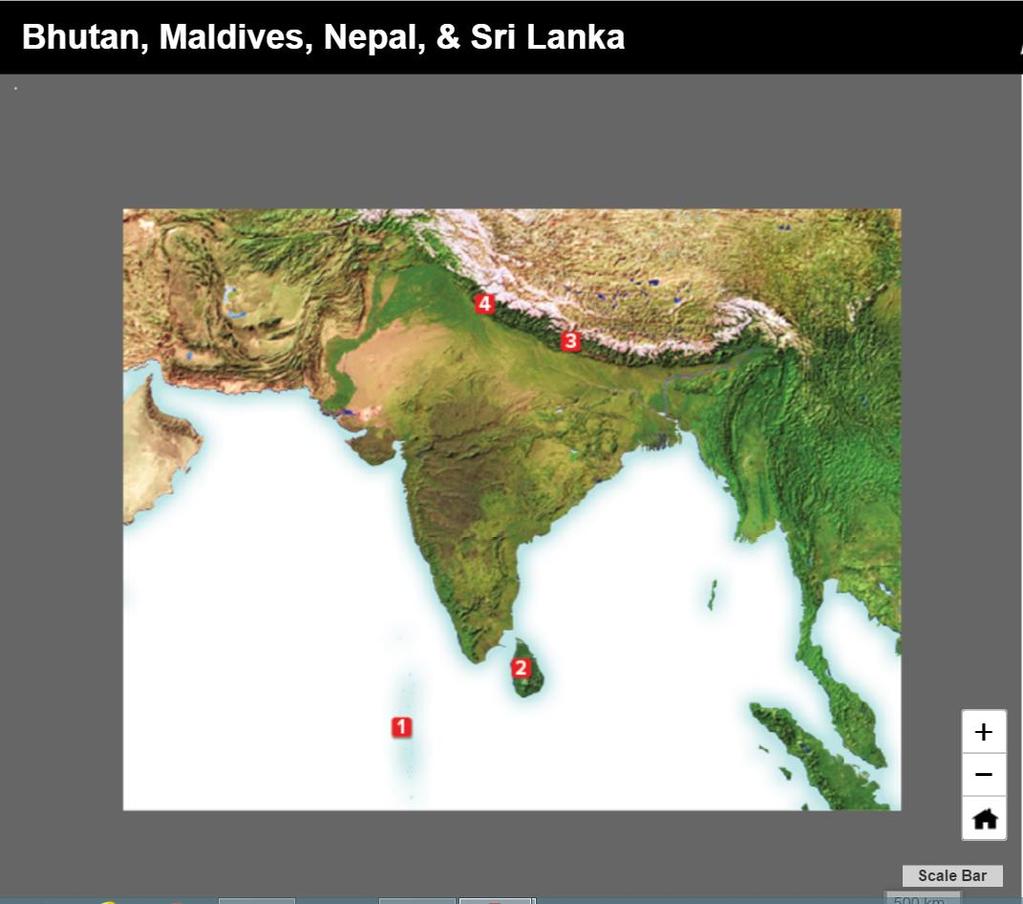
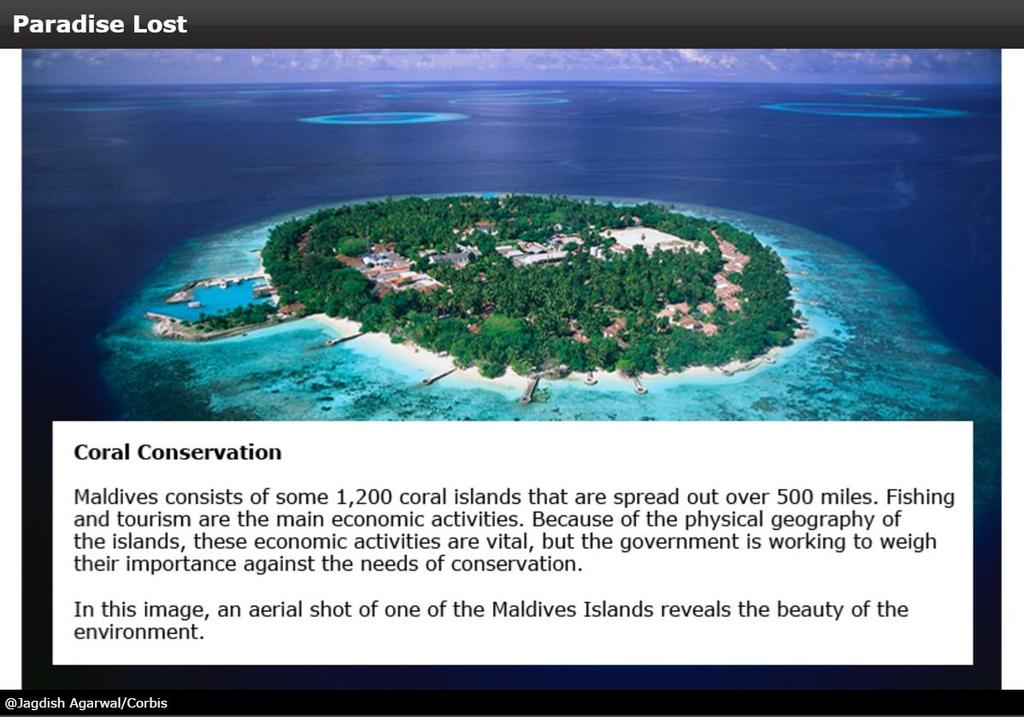
3 Physical Geography of Bhutan, Maldives, Nepal & Sri Lanka Landforms Their locations on the fringe of South Asia means their physical and human geography have been influenced by the South Asian core. Nepal and Bhutan each have four geographic zones, with few people living in the rugged mountain areas. Sri Lanka has two regions, a mountain range in the Central Highlands and a plain the covers most of the island. Maldives is a scattered collection of 1,200 islands grouped into thirteen atolls with barrier reefs.
4
5 Physical Geography of Bhutan, Maldives, Nepal & Sri Lanka Water Systems Nepal s fast-flowing rivers feed into the Ganges and have great potential, or ability to be developed, as a source of hydroelectric power. Bhutan s rivers supply the Brahmaputra. Sri Lanka s Mahaweli features many spectacular waterfalls and helps irrigate fields. Maldives has underground aquifers, water-bearing layers of porous rock, that supply water. The Indian Ocean surrounds Maldives and Sri Lanka and offers both benefits and dangers.
6 Physical Geography of Bhutan, Maldives, Nepal & Sri Lanka Climates, Biomes, & Resources Monsoons affect the climates of all four countries. Nepal and Bhutan each have four climate zones due in part to large variations in elevation. Maldives has a humid tropical climate. Sri Lanka has a humid tropical climate in the lowlands and a cooler climate in the highlands. Bhutan has been successful in making use of, or exploiting, its hydroelectric power. Sri Lanka has many mineral resources.
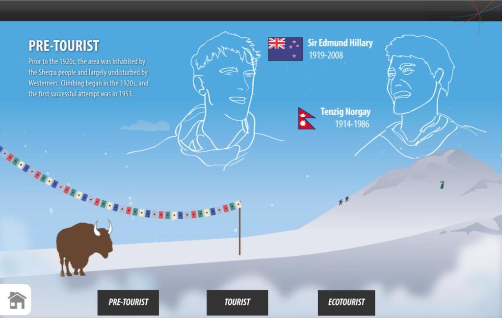
7 Human Geography of Bhutan, Maldives, Nepal & Sri Lanka History & Government In 1600s Bhutan, a Tibetan lama, or Buddhist monk, consolidated religious and political power; however, today it is a constitutional monarchy. Historically ruled by many smaller kingdoms, modern Nepal has wavered between representative government and rule by the king. Under European control for centuries, Maldives became a republic in Sri Lanka adopted a parliamentary government after independence from Britain in 1948.
8
9
10
11
12
13
14
15 Human Geography of Bhutan, Maldives, Nepal & Sri Lanka Population Patterns Nepal is the most populous country of the region, with 30.9 million people. Bhutan s 700,000 people live in pockets across the rugged terrain. Sri Lanka has a population of 21.2 million people, with most living near the capital, Colombo. The city of Male is the most populous settlement in Maldives, with a third of the country s 300,000 people.
16
17
18
19
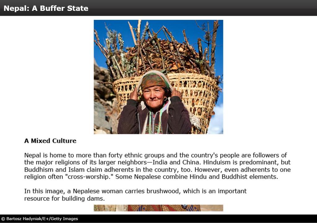
20 Human Geography of Bhutan, Maldives, Nepal & Sri Lanka Society & Culture Today Nepal s population is mostly Hindu, with the remaining ten percent Buddhist. The Bhote in Bhutan are descendants of Tibetan peoples, and most are Buddhist. Sri Lanka s majority Sinhalese population is Buddhist, and the Tamil minority is Hindu. Maldives is a mix of Sinhalese, East African, and Arabic peoples. Women often have second-class status in these societies.
21
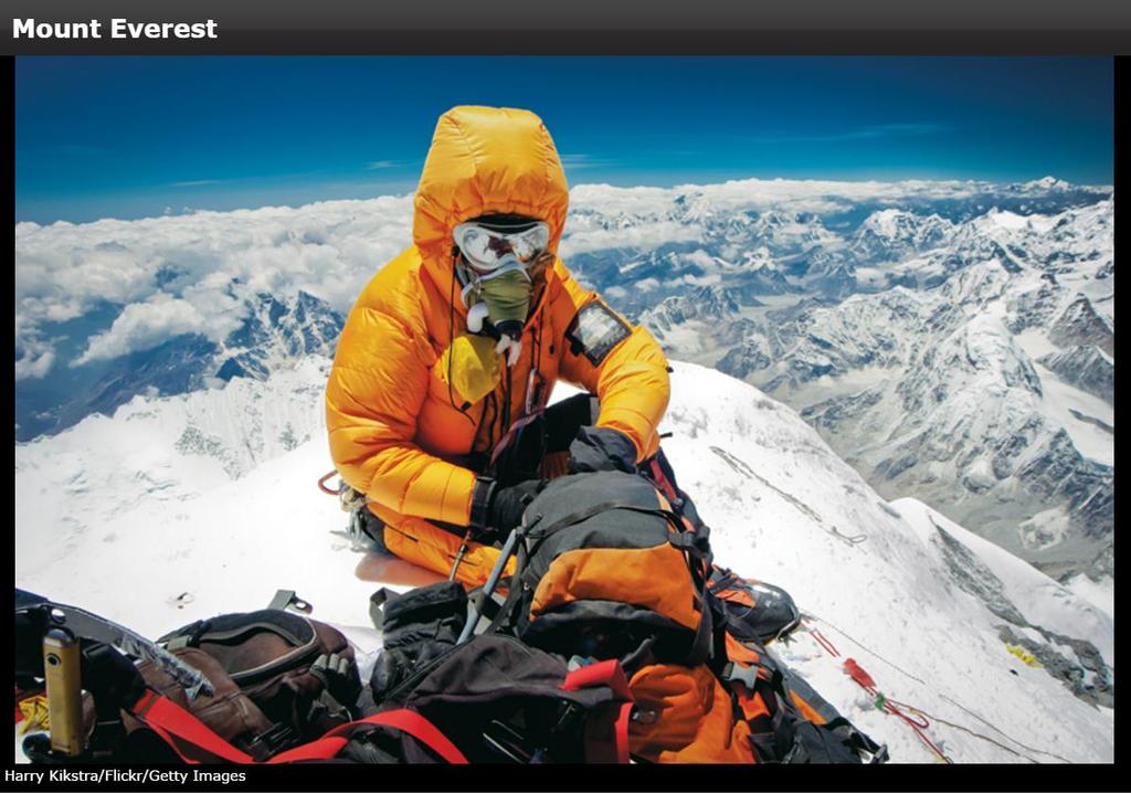
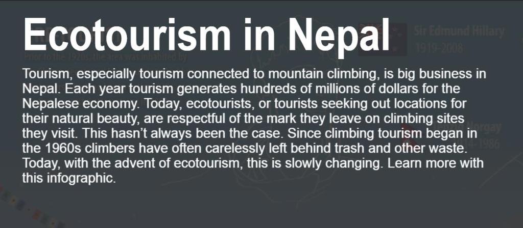
22 Human Geography of Bhutan, Maldives, Nepal & Sri Lanka Economic Activities These countries are not very economically developed because they have relatively few resources and are remote. Nearly 75 percent of Nepalese are engaged in agriculture and herding, with farmers practicing terracing to make the most use of the land. Tourism is an important part of the economy in the region, with hiking, rafting, and touring religious sites being popular in Bhutan and Nepal, while in Sri Lanka and Maldives, people enjoy the beaches.
23
24
25
26
27
28
29
30 People and Their Environment: Bhutan, Maldives, Nepal & Sri Lanka Managing Resources As poor countries generally lacking in technology, these countries face obstacles to achieving sustainable development. Culturally, they do have advantages, as Buddhist tradition encourages respect for nature and the value of all life forms. These countries have made some progress as they realize that if they lose their natural beauty they will lose their tourist appeal.
31
32
33
34
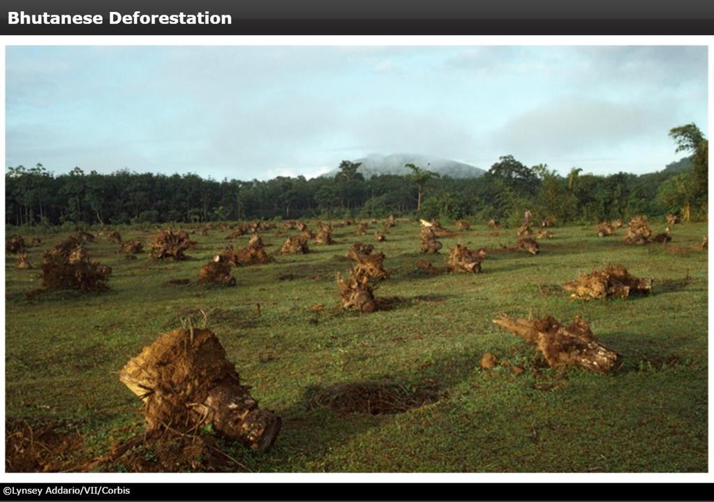
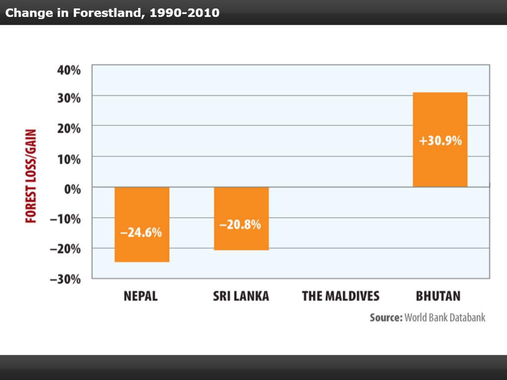
35 People and Their Environment: Bhutan, Maldives, Nepal & Sri Lanka Human Impact Major environmental problems include deforestation, along with soil and water issues. Commercial timber companies have used clearcutting, or the removal of all trees in a stand of timber, to harvest logs, harming forests. As rain forests disappear, soil erodes, rains produce floods, and temperatures rise. The wide array of endangered and rare wildlife is threatened by encroaching settlements and poaching.
36
37
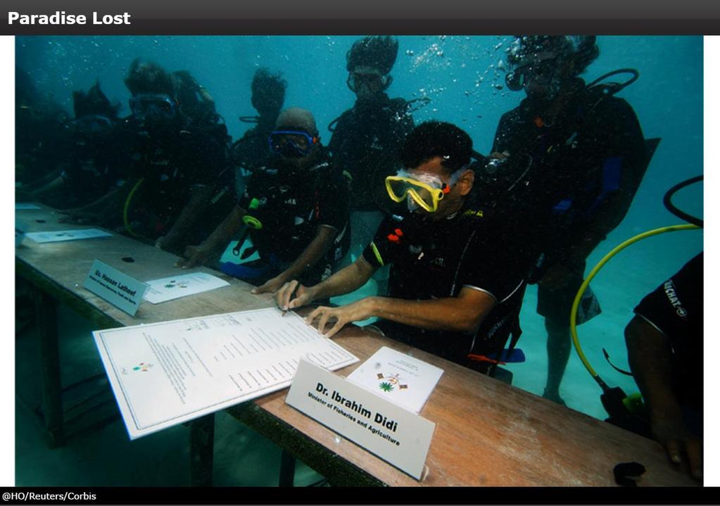
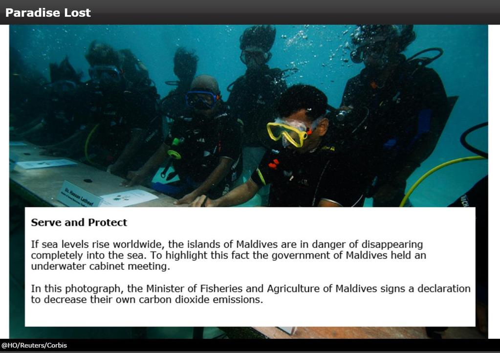
38 People and Their Environment: Bhutan, Maldives, Nepal & Sri Lanka Addressing the Issues Bhutan s constitution requires it to keep 60 percent of its land forested and it encourages organic farming, or the use of natural substances rather than chemical fertilizers to grow crops. Sri Lanka s Ministry of Environment and Natural Resources raises environmental action to the cabinet level. Maldives has launched programs to limit fossil fuels and hopes, along with Bhutan, to have no carbon emissions by 2020.
39
40
41
42
Chapter 27. Bhutan, Maldives, Nepal, & Sri Lanka
 Chapter 27 Bhutan, Maldives, Nepal, & Sri Lanka Physical Geography of Bhutan, Maldives, Nepal & Sri Lanka Landforms Their locations on the fringe of South Asia means their physical and human geography
Chapter 32. Australia & New Zealand
 Chapter 32 Australia & New Zealand Lesson 1: Physical Geography of Australia & New Zealand Landforms Australia lies between the Pacific and Indian Oceans in the Southern Hemisphere. Although an island,
Chapter 32. Australia & New Zealand
 Chapter 32 Australia & New Zealand Lesson 1: Physical Geography of Australia & New Zealand Landforms Australia lies between the Pacific and Indian Oceans in the Southern Hemisphere. Although an island,
The Impact of Geography in South and East Asia
 The Impact of Geography in South and East Asia Gobi desert, Mongolia Essential Question: How does geography impact the distribution of population throughout South and East Asia? I CAN Explain how geography
The Impact of Geography in South and East Asia
 The Impact of Geography in South and East Asia Gobi desert, Mongolia Essential Question: How does the geography of SE Asia impact trade and the distribution of population throughout the region? (AKS #52a)
The Impact of Geography in South and East Asia
 The Impact of Geography in South and East Asia Gobi desert, Mongolia Essential Question: How does the geography of SE Asia impact trade and the distribution of population throughout the region? (AKS #52a)
Landforms. Lesson 1: Physical Geography of Canada Mexico. Canada s mountainous eastern and western edges create a central region of fertile plains.
 Lesson 1: Physical Geography of Canada Mexico Landforms Canada s mountainous eastern and western edges create a central region of fertile plains. Collisions of tectonic plates thrust up a series of sharp-peaked
UNIT 11 SOUTH ASIA SG 1 - PHYSICAL GEOGRAPHY & THE ENVIRONMENT
 UNIT 11 SOUTH ASIA SG 1 - PHYSICAL GEOGRAPHY & THE ENVIRONMENT I. PHYSICAL GEOGRAPHY TAKE OUT YOUR PHYSICAL MAP OF SOUTH ASIA A. The Himalayan Mountains form the northern boundary of the region (color
The study of Geography and the use of geographic tools help us view the world in new ways.
 S How does Geography help us understand our world? What factors shape the Earth s different environments? 7.1.9 7.2.9 BIG IDEAS COMPETENCIES Text pages or The study of Geography and the use of geographic
Chapter 23. Equatorial Africa
 Chapter 23 Equatorial Africa Section 1 - Physical Geography of Equatorial Africa Landforms Equatorial Africa, or the Heart of Africa, is a tropical subregion located on and near the Equator in Central
World Geography Fall 2013 Semester Review Project
 Reporting Category RC 1: History, Government and Citizenship Standard WG.1 History. The student understands how geography and processes of spatial exchange (diffusion) influenced events in the past and
Chapter 24 Southern Africa
 Chapter 24 Southern Africa Section 1 - Physical Geography of Southern Africa Landforms Southern Africa consists of ten mainland countries and four island countries. Most of Southern Africa sits at a high
Wednesday, May 23, 2018
 Wednesday, May 23, 2018 Physical Geography of West Africa Objective: Summarize the main geographic aspects of each country in West Africa. Understand each country s development pattern and their current
Chapter 21 Southwest Asia: Harsh & Arid Lands
 Name Hour Chapter 21 Southwest Asia: Harsh & Arid Lands Essential Question: How has the physical geography of Asia influenced the development of these regions (i.e. history, population distribution, &
Mitigating the human-elephant conflict in Sri Lanka: lessons from Southern Africa
 Mitigating the human-elephant conflict in Sri Lanka: lessons from Southern Africa Sanjay Kalpage 7 th International Wildlife Ranching Symposium Kimberly, South Africa, 11 th October, 2011 1 Overview Sri
South, Southeast, and East Asia. Physical Geography
 South, Southeast, and East Asia Physical Geography Mountains v Mountains are important in Asia because they influence: A. Population patterns B. Movement of people and goods C. Climate Mountains v The
Geography of the Americas
 STATION ACTIVITY Geography of the Americas NAME: Directions: Using each station s text and maps, complete this graphic organizer. Olmec Mayans Aztecs Incas Where was this people group located? (include
*X208/11/01* X208/11/01 GEOGRAPHY INTERMEDIATE 2 NATIONAL QUALIFICATIONS 2014 THURSDAY, 29 MAY 9.00 AM AM
 X208/11/01 NATIONAL QUALIFICATIONS 2014 THURSDAY, 29 MAY 9.00 AM 11.00 AM GEOGRAPHY INTERMEDIATE 2 Candidates should answer four questions: Section A Question 1 and Question 2 AND Section B any two questions
Explain the impact of location, climate, natural resources, and population distribution on Europe. a. Compare how the location, climate, and natural
 SS6G10 Explain the impact of location, climate, natural resources, and population distribution on Europe. a. Compare how the location, climate, and natural resources of Germany, the United Kingdom and
Regional Atlas Activity C
 Political Location Activity AUSTRALIA, OCEANIA, AND ANTARCTICA Regional Atlas Activity C DIRECTIONS: Identify each country marked by a number on the map. Then write the correct name on the numbered blanks
Unit 1: Basics of Geography Test Review
 Name Date Period Unit 1: Basics of Geography Test Review Directions: Reading the following sections and complete the questions, charts, and diagrams. Types of Maps Maps that have a particular theme are
September 14, 2013 Objective: How does geography impact history? What important features exist that have shaped societies?
 Lowenhaupt 1 September 14, 2013 Objective: How does geography impact history? What important features exist that have shaped societies? Warm-Up: In your binder, answer the following question: Imagine you
Sec$on 1: Geography and Early China. How does China s geography affect the culture?
 Sec$on 1: Geography and Early China How does China s geography affect the culture? Con$nents of the World Label the continents. Where is China located? Where is China located? In your groups, begin filling
About places and/or important events Landmarks Maps How the land is, hills or flat or mountain range Connected to maps World Different countries
 What do you think you know about geography? About places and/or important events Landmarks Maps How the land is, hills or flat or mountain range Connected to maps World Different countries What do you
Physical Geography of East Asia
 Physical Geography of East Asia Satellite View of China Landforms of China China s Geography China Miles 0 250 500 1,000 1,500 2,000 United States 3 rd largest country in the world. Comparable to the US
Australia and New Zealand: Powerpoint
 Australia and New Zealand: Powerpoint Physical Geography Australia and New Zealand are between the Indian and Pacific Oceans. Australia s seasons are opposite of the United States due to their location.
GEOGRAPHY. In relation to the above aims, candidates should, after completing this syllabus, be able to
 GEOGRAPHY AIMS The aims of this syllabus are to enable candidates 1. to recognize and understand the arrangement of phenomena and features on Earth as well as the inter-relationship and interaction among
Physical Geography of the United States and Canada Chapter 5 A Land of Contrasts
 Physical Geography of the United States and Canada Chapter 5 A Land of Contrasts Land Area Together the U.S. and Canada cover more than 7 million square miles. In total area, Canada ranks 2 nd and the
MASSACHUSETTS HISTORY & SOCIAL SCIENCE LEARNING STANDARDS Grade 6 HISTORY AND GEOGRAPHY
 Massachusetts History and Social Science Curriculum Framework Learning Standards, World Geography (Grade 6) Grade 6 HISTORY AND GEOGRAPHY 1. Use map and globe skills learned in prekindergarten to grade
Post Test Trimester 1 US & Canada 6th Grade-Study Guide
 Post Test Trimester 1 US & Canada 6th Grade-Study Guide Matching Fill in the blank by writing the letter of the correct term below. a. dominion f. indigenous b. Industrial Revolution g. interdependent
Unit 3- Latin America Study Guide Answers
 Unit 3- Latin America Study Guide Answers Multiple Choice Why did many indigenous communities in South America develop as isolated groups? T H E Y W E R E S E P A R A T E D B Y T H E N A T U R A L B A
5th social studies geography (5thsocstud_geography)
") Name: Date: 1. Many of the Native Americans who lived on the Great Plains were nomadic people. Why did they move from place to place? A. They were finding new areas to mine. B. They were looking for fertile
Name: Date: 1. Many of the Native Americans who lived on the Great Plains were nomadic people. Why did they move from place to place? A. They were finding new areas to mine. B. They were looking for fertile
MARS AREA SCHOOL DISTRICT CURRICULUM GRADE: Grade 4
 MARS AREA SCHOOL DISTRICT CURRICULUM GRADE: Grade 4 Course Title: Social Studies Brief Description Overview: Students will explore the history, geography, government, and economy of the United States with
STAAR Vocabulary Words extracted directly from the standard and/or associated with the instruction of the content within the standard.
 STAAR Vocabulary Words extracted directly from the standard and/or associated with the instruction of the content within the standard. READINESS STANDARDS - World Geography (WG.1) History. The student
Changes in Texas Ecoregions
 Comment On Lesson Changes in Texas Ecoregions The state of Texas can be divided into 10 distinct areas based on unique combinations of vegetation, topography, landforms, wildlife, soil, rock, climate,
World Geography TEKS 2nd Nine Weeks. Unit of Study Regional Studies; U.S. and Canada Regional Studies; Latin America; and Europe
 World Geography TEKS 2nd Nine Weeks Unit of Study Regional Studies; U.S. and Canada Regional Studies; Latin America; and Europe 1) History. The student understands how geography and processes of spatial
Today s Chunks of Learning:
 Geography 11-1-2018 Today s Chunks of Learning: Chunk 1 Patterns of Globalization in Central and South America (continued). Chunk 2 Physical Geography of Sub-Saharan Africa. Chunk 1: These countries have
Social Science Holidays Homework Class 8 th
 Social Science Holidays Homework Class 8 th Projects For summer Vacations;- 1. Make a project on the topic Tribals, Dikus and the vision of a Golden age using the following guide points:- (a) Tribal occupation
ANALYZING CITIES & POPULATION: POPULATION GEOGRAPHY
 ANALYZING CITIES & POPULATION: POPULATION GEOGRAPHY Population Geography Population Geography study of the number, contribution, and distribution of human populations Demography the study of the characteristics
World Geography Review Syllabus
 Purpose Class: World Geography Review Syllabus This course is designed to help students review and remediate their understanding major themes, concepts, and facts connected to the study World Geography.
What is the largest country in the world? Russia
 What is the largest country in the world? #1 Russia CSCOPE 2007 2 Russia Dimensions #2-3 Spans 11 Time Zones From East to West: Gulf of Finland to Alaska From North to South: Above the Arctic Circle to
Amarillo ISD Social Studies Curriculum
 Amarillo Independent School District follows the Texas Essential Knowledge and Skills (TEKS). All of AISD curriculum and documents and resources are aligned to the TEKS. The State of Texas State Board
Subunit 4.1: 2.5 hours. Subunit 4.2: 2.75 hours. Subunit 4.3: 1.5 hours. Subunit 4.4: 3.5 hours. Subunit 4.5: 1.5 hours Unit 4 Learning Outcomes close
 Unit 4: North America The realm of North America extends from the polar regions of the Arctic in northern Canada and Alaska, all the way south through Mexico and the countries of Central America. Geographers
The Geography Curriculum at Coston Primary
 The Geography Curriculum at Coston Primary Years Year 1 Year 2 Summer We are learning about where food is farmed and in The physical features of farms. The human features of farms. The characteristics
Academic Vocabulary CONTENT BUILDER FOR THE PLC WORLD GEOGRAPHY
 Academic Vocabulary CONTENT BUILDER FOR THE PLC WORLD GEOGRAPHY : academic vocabulary directly taken from the standard STANDARD WG.1A analyze the effects of physical and human geographic patterns and processes
Activity 2.2: Recognizing Change (Observation vs. Inference)
") Activity 2.2: Recognizing Change (Observation vs. Inference) Teacher Notes: Evidence for Climate Change PowerPoint Slide 1 Slide 2 Introduction Image 1 (Namib Desert, Namibia) The sun is on the horizon
Activity 2.2: Recognizing Change (Observation vs. Inference) Teacher Notes: Evidence for Climate Change PowerPoint Slide 1 Slide 2 Introduction Image 1 (Namib Desert, Namibia) The sun is on the horizon
Physical Geography: Patterns, Processes, and Interactions, Grade 11, University/College Expectations
 Geographic Foundations: Space and Systems SSV.01 explain major theories of the origin and internal structure of the earth; Page 1 SSV.02 demonstrate an understanding of the principal features of the earth
Curriculum Unit. Instructional Unit #1
 Curriculum Unit Name of Course: AP Human Geography Grade Level(s): 9-12 Brief Description (Course Catalog): The purpose of the AP Human Geography course is to introduce students to the systematic study
M14/3/GEOGR/SP2/ENG/TZ0/XX/Q GEOGRAPHY STANDARD LEVEL PAPER 2. Monday 19 May 2014 (morning) 1 hour 20 minutes INSTRUCTIONS TO CANDIDATES
 1 hour 20 minutes INSTRUCTIONS TO CANDIDATES") M14/3/GEOGR/SP2/ENG/TZ0/XX/Q 22145203 GEOGRAPHY STANDARD LEVEL PAPER 2 Monday 19 May 2014 (morning) 1 hour 20 minutes INSTRUCTIONS TO CANDIDATES Do not open this examination paper until instructed to do
M14/3/GEOGR/SP2/ENG/TZ0/XX/Q 22145203 GEOGRAPHY STANDARD LEVEL PAPER 2 Monday 19 May 2014 (morning) 1 hour 20 minutes INSTRUCTIONS TO CANDIDATES Do not open this examination paper until instructed to do
Arizona Educator Proficiency Assessments (AEPA ) FIELD 04: GEOGRAPHY TEST OBJECTIVES
 FIELD 04: GEOGRAPHY TEST OBJECTIVES") Arizona Educator Proficiency Assessments (AEPA ) TEST OBJECTIVES Subarea Range of Objectives Approximate Test Proportions I. Geographic Concepts and Skills 1 6 25% II. World Geography 7 14 34% III. United
Arizona Educator Proficiency Assessments (AEPA ) TEST OBJECTIVES Subarea Range of Objectives Approximate Test Proportions I. Geographic Concepts and Skills 1 6 25% II. World Geography 7 14 34% III. United
Minnesota K-12 Academic Standards in Social Studies. Grade 4: Geography of North America
 Minnesota K-12 Academic s in Social Studies Grade 4: Geography of North America 4 Describe how people take 1. Democratic government action to influence a depends on informed and decision on a specific
TYPES OF GOVERNMENTS
 While the terms country, state, and nation are often used interchangeably, there is a difference. A State (note the capital "S") is a self-governing political entity. The term State can be used interchangeably
Overview of the Exam and Syllabus
 Overview of the Exam and Syllabus Paper 01 consists of 60 multiple-choice items drawn from all areas of the syllabus. The time given to do this paper is one and a half hours. It is marked out of 60 and
Landforms in Canada. Canada is made up of three dis;nct types of landforms: Canadian Shield Highlands Lowlands
 Canada s Landforms What is a Landform? A landform is any physical feature of the Earth s surface having a characteris;c, recognizable shape, produced by natural causes. Landforms include major features
Witchampton CofE First School Geography Curriculum Map
 2016-2017 Autumn People and : 30-50 Show interest in the lives of people who are familiar to them. Shows interest in different occupations. Remembers and talks significant events in their own experience.
Grade 7 Social Studies
 Standard 1: History Students will examine the major movements, events, and figures that contributed to the development of nations in modern Africa, Asia, and the Southwest Pacific from acient civilizations
Eastern Hemisphere Geography 7th Grade *Chapters 1-10 covered in 6 th Grade
 Quarter 1 Geography Tools and Concepts Chapters 1-5 Intro to Geography = 2 day review Goal Objective Task Analysis Vocabulary Text Location Goal 2.1: Analyze the 6-9.GEH.2.1.1 Explain and use the Identify
Subject Area: Geography
 Long Term Planning Overview Key Stage 3 Subject Area: Geography Academic : 08-9 7 Assessment Your Island Home the physical and human geography of the UK and will investigate weather patterns, population
Unit: Africa. Learning Standards / Essential Knowledge Concepts and Skills Essential Questions
 Unit: Africa Learning Standards / Essential Knowledge Concepts and Skills Essential Questions 6 A. 1 On a map of the world, locate the continent of Africa, the Atlantic Ocean, the Indian Ocean, the Mediterranean
Prentice Hall. World Explorer: People, Places, Cultures Grade 7. Oklahoma Priority Academic Student Skills (PASS) for Grade 7 World Geography
 for Grade 7 World Geography") Prentice Hall World Explorer: People, Places, Cultures 2007 Grade 7 C O R R E L A T E D T O for Grade 7 1. Locate, gather, analyze, and apply information from primary and secondary sources. WORLD GEOGRAPHY
Prentice Hall World Explorer: People, Places, Cultures 2007 Grade 7 C O R R E L A T E D T O for Grade 7 1. Locate, gather, analyze, and apply information from primary and secondary sources. WORLD GEOGRAPHY
Thursday, April 27, 17
 Thursday, April 27, 17 Geography of Southeast Asia Objec-ve: Understand the geographical differences between the mainland region and the insular region of Southeast Asia. Do Now: What is the capital of
Exploring the Geography of West Asia
 Unit 3 - Lesson 1 Content Expectations 7 G1.1.1: Explain and use a variety of maps, globes, and web based geography technology to study the world, including global, interregional, regional, and local scales.
Passwords. Social Studies Vocabulary. Texas: Grade 7
 Passwords Social Studies Vocabulary Texas: Grade 7 To the Student What is federalism? How are independence and interdependence different? What does an anthropologist do? Passwords: Social Studies Vocabulary
OUR COUNTRY INDIA LOCATIONAL SETTING
 7 India is a country of vast geographical expanse. In the north, it is bound by the lofty Himalayas. The Arabian Sea in the west, the Bay of Bengal in the east and the Indian Ocean in the south, wash the
By Geri Flanary To accompany AP Human Geography: A Study Guide 3 rd edition By Ethel Wood
 Session 1 By Geri Flanary To accompany AP Human Geography: A Study Guide 3 rd edition By Ethel Wood WHAT IS DEMOGRAPHY? It is the scientific or statistical study of population. It comes from the Greek
Social Studies World Geography Unit 01: Physical Geography
 Social Studies World Geography Unit 01: Physical 012 2013 1 Tectonic plate movement may be caused by all of the following EXCEPT A slab pull B ridge push C convection D magnetism 2 An earthquake is part
The Hemet Unified School District HISTORY/SOCIAL SCIENCE Content Standards In the Classroom
 The Hemet Unified School District HISTORY/SOCIAL SCIENCE Content Standards In the Classroom By the end of fourth grade students will: Demonstrate an understanding of the physical and human geographic features
Social Studies: The World Post Test Study Guide
 Name: Period: Social Studies: The World Post Test Study Guide Map and Globe Skills: Label the continents and oceans on the lines below the map. 1 11 3 4 5 8 2 9 10 8 6 7 1. 8. 2. 9. 3. 10. 4. 11. 5. 6.
SOCIAL STUDIES GRADE 5. I Can Checklist Office of Teaching and Learning Curriculum Division REGIONS AND PEOPLE OF THE WESTERN HEMISPHERE
 SOCIAL STUDIES REGIONS AND PEOPLE OF THE WESTERN HEMISPHERE GRADE 5 I Can Checklist 2015-2016 Aligned with Ohio s Learning Standards for Social Studies Office of Teaching and Learning Curriculum Division
Grade Level Expectations for the Sunshine State Standards
 for the Sunshine State Standards FLORIDA DEPARTMENT OF EDUCATION http://www.myfloridaeducation.com/ The sixth grade student: Time, Continuity, and Change [History] understands that historical events are
Chapter 4A: The Middle America Realm
 Geography: Realms, Regions and Concepts 15 th Edition By de Blij and Muller Chapter 4A: The Middle America Realm Geographical Features: The Realm s Northern Land Boundary Longest land border between realms
Grade 7 History Mr. Norton
 Grade 7 History Mr. Norton Section 1: Thinking Geographically Section 2: Land and Climates of the United States Section 3: The Tools of History Section 4: Economics and Other Social Sciences Grade 7 History
Regional Geography C. LANGDON WHITE. Professor Emeritus Stanford University EDWIN J. FOSCUE TOM L. MCKNIGHT
 Regional Geography of Anglo-America Sixth Edition C. LANGDON WHITE Professor Emeritus Stanford University EDWIN J. FOSCUE Late of Southern Methodist University TOM L. MCKNIGHT Professor of Geography University
New National Curriculum Geography Skills Planning KS1
 New National Curriculum Geography Skills Planning KS1 Enquiry Question Objective-essential knowledge skills or understanding Locational Knowledge Standards /Success Criteria Lesson progression over half
The United States & Canada. A Regional Study of Anglo America
 A Regional Study of Anglo America Landform Regions of the United States & Canada world leaders in agricultural and industrial production because of... VAST LANDS stretch from the Atlantic Ocean on the
Downloaded from
 GIST OF THE LESSON: General patternsof population distribution in the world, density of population, factors influencing the distribution of population, population growth, trends in population growth, doubling
Prentice Hall World Studies 2005, Eastern Hemisphere Correlated to: Maryland Social Studies State Voluntary Curriculum (Grade 7)
") Prentice Hall World Studies 2005, Eastern Hemisphere Maryland Social Studies State Voluntary Curriculum (Grade 7) Social Studies Grade 7 Voluntary Curriculum History: Students will examine significant
Prentice Hall World Studies 2005, Eastern Hemisphere Maryland Social Studies State Voluntary Curriculum (Grade 7) Social Studies Grade 7 Voluntary Curriculum History: Students will examine significant
Barlows Primary School Geography Curriculum Content Key Stage 1 and
 Geography Curriculum Content Key Stage 1 and 2 2017-2018 Curriculum Content Year 1 The content for Year 1 is detailed below: WHAT ARE SEASONS? WHAT SIT LIKE WHERE WE LIVE? WHERE DO DIFFERENT ANIMALS LIVE?
Content Area: Social Studies Standard: 1. History Prepared Graduates: Develop an understanding of how people view, construct, and interpret history
 Standard: 1. History Develop an understanding of how people view, construct, and interpret history 1. Organize and sequence events to understand the concepts of chronology and cause and effect in the history
Geography Skills Progression. Eden Park Primary School Academy
 Geography Skills Progression Eden Park Primary School Academy In order to ensure broad and balanced coverage, we follow these principles: Within each phase, geography is a driver for at least 3 Learning
UNIVERSITY OF CAMBRIDGE INTERNATIONAL EXAMINATIONS International General Certificate of Secondary Education
 UNIVERSITY OF CAMBRIDGE INTERNATIONAL EXAMINATIONS International General Certificate of Secondary Education *6115756043* GEOGRAPHY 0460/12 Paper 1 October/November 2011 1 hour 45 minutes Candidates answer
K- 5 Academic Standards in. Social Studies. June 2013
 K- 5 Academic s in Social Studies June 2013 Word Tables of s ONLY This Word version of the 2.17.12 social studies standards (DRAFT for Rulemaking 2.17.12) document contains the standards ONLY; no explanatory
Chapter 1: America s Land Lesson 1: Land and Climate
 Chapter 1: America s Land Lesson 1: Land and Climate Geography: Describe landforms and other physical features of the United States. Geography: Explain how and why climate varies throughout the United
Site and Situation. Site
 Site and Situation The study of settlement patterns is one of the most important aspects of urban geography. Settlements can range in size from a small village with a few hundred residents to a metropolitan
Directed Reading. Section: Types of Maps
 Skills Worksheet Directed Reading Section: Types of Maps 1. What are some of the characteristics of an area shown on maps used by Earth scientists? a. types of animals, types of plants, types of minerals
PALEOGEOGRAPHY of NYS. Definitions GEOLOGIC PROCESSES. Faulting. Folding 9/6/2012. TOPOGRAPHIC RELIEF MAP of NYS GRADATIONAL TECTONIC
 TOPOGRAPHIC RELIEF MAP of NYS PALEOGEOGRAPHY of NYS Prof. Anthony Grande AFG 2012 Definitions GEOLOGIC PROCESSES Geography: study of people living on the surface of the earth. Geology: the scientific study
Downloaded from
 SOCIAL STUDIESCLASS - V LESSON-1 GLOBE ANSWER THE FOLLOWING: 1. Name the continents and oceans on the earth. Ans. The seven continents are: a) Australia b) Europe c) Antarctica d) South America e) North
This table connects the content provided by Education Perfect to the NSW Syllabus.
 Education Perfect Geography provides teachers with a wide range of quality, engaging and innovative content to drive positive student learning outcomes. Designed by teachers and written by our in-house
Geography Teach Yourself Series Topic 4: Global Distribution of Land Cover
 Geography Teach Yourself Series Topic 4: Global Distribution of Land Cover A: Level 14, 474 Flinders Street Melbourne VIC 3000 T: 1300 134 518 W: tssm.com.au E: info@tssm.com.au TSSM 2016 Page 1 of 7 Contents
2008 SIVECO Romania. All Rights Reserved. Geography. AeL econtent Catalogue
 2008 SIVECO Romania. All Rights Reserved. Geography AeL econtent Catalogue The Earth's Movements Recommended for two hours of teaching. AeL Code: 352. 2. The Earth Rotation Movement in 24 hours 3. The
Changes in Texas Ecoregions Copy the questions and answers
 Changes in Texas Ecoregions Copy the questions and answers 1. What are some kinds of damage that hurricanes cause? Roads and bridges might be washed away. Trees and power lines can be knocked down. Area
Complete Geography Overview: Year 1 to Year 6
 Option 1 Complete Geography Overview: Year 1 to Year 6 Autumn Term Spring Term Summer Term Year 1 Where do I live? Around the World The Four Seasons Year 2 At the Farm Let s go on Safari My World and Me
GEOGRAPHY PAPER 312/ 1 K.C.S.E 1997 SECTION A Answer all the questions in this section.
 GEOGRAPHY PAPER 312/ 1 K.C.S.E 1997 SECTION A Answer all the questions in this section. 1. The diagram below shows the structure of the earth. Name the parts marked p, q and R Name the minerals that make
Terrain Units PALEOGEOGRAPHY: LANDFORM CREATION. Present Geology of NYS. Detailed Geologic Map of NYS
 NYS TOPOGRAPHY Why so? PALEOGEOGRAPHY: LANDFORM CREATION Prof. Anthony Grande AFG 014 Present Geology of NYS Detailed Geologic Map of NYS Generalized Geology Detailed Geology Hot links to the fold out
Physical Geography. Ariel view of the Amazon Rainforest. A Look at the Seven Continents
 Physical Geography In this unit you will learn about general physical geography. The study of the Earth s surface features provides the setting for the human-environmental interactions and for the human
Geography Mile Post 1
 Mile Post 1 Use world maps, atlases and globes to identify the UK and its countries, as well as the countries, continents and oceans studied at this key stage Key Skills IPC learning Goals 1.11 Be able
Preview: Making a Mental Map of the Region
 Preview: Making a Mental Map of the Region Look at the outline map of Monsoon Asia on the next page. Add a compass rose to the map, showing where north, south, east, and west are. Then draw or shade and
Different types of maps and how to read them.
 Different types of maps and how to read them. A map is a picture or representation of the Earth's surface, showing how things are related to each other by distance, direction, and size. Maps have been
TRIBUNE MODEL SCHOOL Syllabus for Session Subject: Social Science CLASS IV
 TRIBUNE MODEL SCHOOL Syllabus for Session 2017-18 Subject: Social Science CLASS IV Text Books 1. Candid New Trends in Social Science 4 2. Candid New Trends in Social Science (Worksheets) 4 Term I (Chapters
Natural Texas. Regions and Climates
 Natural Texas Regions and Climates Two Kinds: Physical geography Climate, vegetation, rivers, lakes, oceans, plateaus, plains, and mountain ranges Human geography Economic activities How we earn a living