*X208/11/01* X208/11/01 GEOGRAPHY INTERMEDIATE 2 NATIONAL QUALIFICATIONS 2014 THURSDAY, 29 MAY 9.00 AM AM
|
|
|
- Leonard Cain
- 5 years ago
- Views:
Transcription
1 X208/11/01 NATIONAL QUALIFICATIONS 2014 THURSDAY, 29 MAY 9.00 AM AM GEOGRAPHY INTERMEDIATE 2 Candidates should answer four questions: Section A Question 1 and Question 2 AND Section B any two questions from Questions 3 to 7 Candidates should read the questions carefully. Answers should be clearly expressed and relevant. Credit will always be given for appropriate sketch-maps and diagrams. Write legibly and neatly, and leave a space of about one cm between the lines. All maps and diagrams in this paper have been printed in black only: no other colours have been used. PB *X208/11/01*
2 SECTION A IN THIS SECTION YOU MUST ANSWER QUESTION 1 AND QUESTION 2. Question 1: Physical Environments Map Q1A: Rivers in Scotland A B C (a) Look at Map Q1A. Name rivers A, B and C shown on the map. 3 Page two
 There are many steep cliffs along the coastline shown on the map extract. Explain the coastal erosion processes which lead to the formation of cliffs.")
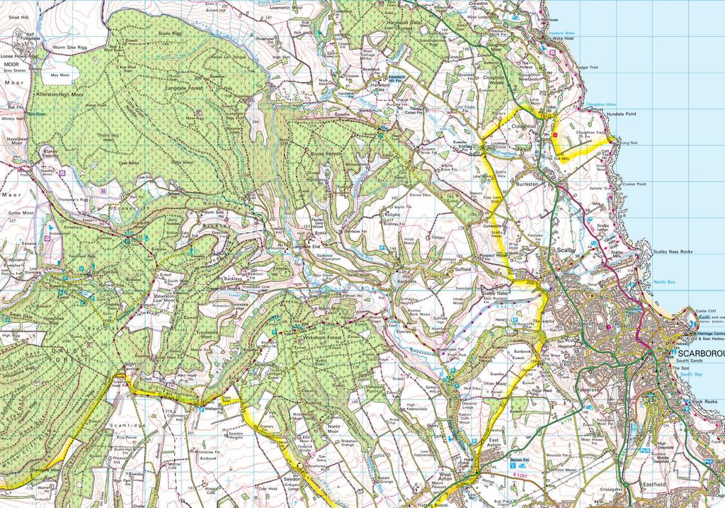
3 1. (continued) (b) Study the Ordnance Survey Map Extract (No 203/101). Describe the physical features of the River Derwent and its valley between 9390 and (c) There are many steep cliffs along the coastline shown on the map extract. Explain the coastal erosion processes which lead to the formation of cliffs. You may wish to use diagrams in your answer. 4 Diagram Q1B: RAF Fylingdales (Grid Reference 8696) (d) Look at the Ordnance Survey Map Extract (No 203/101). For the area shown on the map, or any other area you have studied, describe the advantages and disadvantages of military land use. [Turn over Page three
4 1. (continued) Diagram Q1C: Land Uses in Coastal Areas TOURISM FARMING COASTAL AREAS IN THE UK INDUSTRY RECREATION AND LEISURE (e) Study Diagram Q1C. For a named coastal area you have studied, explain, in detail, ways in which different land uses may be in conflict with each other. (f) Describe the ways public and voluntary organisations help to protect coastal or upland environments. 4 (2) [END OF QUESTION 1] NOW GO ON TO QUESTION 2 Page four
5 Question 2: Human Environments Table Q2A: Africa Projected Population Change Urban population 440 million 160 million Rural population 660 million 70 million (a) Study Diagram Q2A. Referring to rural and urban areas, describe the problems African countries are likely to face due to the population changes which will take place between 2014 and Diagram Q2B: Infant Mortality Rate Argentina 19 Infant mortality rate (per 1000 live births) Year (b) Study Diagram Q2B. Explain why the infant mortality rate in many countries is decreasing. 4 [Turn over Page five

 Study the Ordnance Survey Map Extract (No 203/101).")
6 2. (continued) Diagram Q2C: A Modern City Centre (c) Look at Diagram Q2C. Describe changes which have taken place in city centres in the developed world during the last 30 years. Diagram Q2D: Changes in Agriculture in Developing Countries Changes Increased use of Fertilisers Increased use of Machinery (d) Study Diagram Q2D. Irrigation Explain the advantages and disadvantages of the changes shown in the diagram. 6 (e) Study the Ordnance Survey Map Extract (No 203/101). Explain the advantages of grid square 0284 for the development of a new industrial estate. [END OF SECTION A] 4 (2) NOW TURN TO SECTION B AND ANSWER TWO QUESTIONS Page six
7 SECTION B Environmental Interactions Answer any two questions from this section. Choose from Question 3 Rural Land Degradation (Pages 8 to 9) Question 4 River Basin Management (Pages 10 to 11) Question European Environmental Inequalities (Pages 12 to 13) Question 6 Development and Health (Page 14) Question 7 Environmental Hazards (Page 1) [Turn over Page seven
8 SECTION B Question 3: Rural Land Degradation Diagram Q3A: Population Growth in Niger 1 Diagram Q3B: Niger and the Sahel Region of Africa Population (millions) Year 1000km Key The Sahel Niger (a) Study Diagrams Q3A and Q3B. For Niger, or any other arid or semi arid area you have studied, explain ways in which rapid population growth can lead to increased desertification. Page eight
9 3. (continued) Diagram Q3C: Newspaper Headline Cutting down the world s forests brings many economic advantages, but at a cost to the environment (b) Look at Diagram Q3C. For an area you have studied, describe the environmental impact of deforestation. Diagram Q3D: Remaining Forest Cover in Borneo 60 Million hectares Year (c) Look at Diagram Q3D. Describe ways in which countries such as Borneo can reduce deforestation. (1) [Turn over Page nine
10 Question 4: River Basin Management Diagram Q4A: The Hydrological Cycle (a) Study Diagram Q4A. Describe, in detail, the processes taking place in the hydrological cycle. Page ten
11 4. (continued) Map Q4B: River Brahmaputra CHINA NEPAL Ganges BHUTAN Brahmaputra INDIA BANGLADESH INDIA BURMA Indian Ocean (b) Look at Map Q4B. China is planning a water management project to divert water from the River Brahmaputra. For this, or any other water management project you have studied, explain: (i) why the project was needed; (ii) the environmental and political problems resulting from the project. 4 6 (1) [Turn over Page eleven
12 Question : European Environmental Inequalities Map QA: Air Quality in Europe Key Air Quality Very poor Poor Sufficient Satisfactory Good Very good (a) Study Map QA. Describe the pattern of air quality in Europe. 4 Page twelve
13 . (continued) Diagram QB: Factors Affecting River Pollution Population Density Transport Level of River Pollution Economic Activity (b) Look at Diagram QB. Explain the ways these factors affect the level of pollution in a river. (c) For a mountain or coastal area you have studied: (i) describe measures taken to improve the environmental quality of the area; (ii) comment on the effectiveness of these measures. 6 (1) [Turn over Page thirteen
 Why are combined indicators of development better than using single indicators?")
14 Question 6: Development and Health Map Q6: Human Development Index Key 0 90 and over and under (a) Look at Map Q6. The Human Development Index is an example of a combined indicator of development. (i) Why are combined indicators of development better than using single indicators? (ii) Explain why some areas of the world have a higher level of development than others. 3 6 (b) Heart disease, malaria and AIDS are common diseases. Choose one of these diseases. Describe: (i) the main causes of the disease; (ii) the consequences of the disease for the population in an affected area. 6 (1) Page fourteen
 describe the effects of the storm on local people and the landscape; (ii) explain the importance of aid agencies in helping the area")
15 Question 7: Environmental Hazards Diagram Q7A: Damage Caused by Tropical Storm Nadine 2012 (a) Look at Diagram Q7A. For this or any other named tropical storm you have studied: (i) describe the effects of the storm on local people and the landscape; (ii) explain the importance of aid agencies in helping the area immediately after the storm. [Turn over for Question 7(b) on Page sixteen Page fifteen
16 7. (continued) Table Q7B: Frequency of Earthquakes 2013 Magnitude on Richter Scale Average annually 8 and higher , ,000 (estimated) ,000 (estimated) ,300,000 (estimated) (b) Look at Table Q7B. Describe methods used to predict earthquakes and comment on their effectiveness. (1) [END OF QUESTION PAPER] Page sixteen
17 ACKNOWLEDGEMENTS Diagram Question 2C Shutterstock.com Diagram Question 2D Shutterstock.com Diagram Question 7A Shutterstock.com
18 X208/11/11 NATIONAL QUALIFICATIONS 2014 THURSDAY, 29 MAY 9.00 AM AM GEOGRAPHY INTERMEDIATE 2 Ordnance Survey Map for Questions 1 and 2 ORDNANCE SURVEY MAP Note: The colours used in the printing of this map extract are indicated in the four little boxes at the top of the map extract. Each box should contain a colour; if any does not, the map is incomplete and should be returned to the Invigilator. PB *X208/11/11*
19
Write the numbers of the six questions you have attempted in the marks grid on the back cover of your answer booklet.
 X208/301 NATIONAL QUALIFICATIONS 2008 THURSDAY, 22 MAY 9.00 AM 10.30 AM GEOGRAPHY HIGHER Paper 1 Physical and Human Environments Six questions should be attempted, namely: all four questions in Section
National 5 Geography. Practice Exam Papers
 National 5 Geography Practice Exam Papers December 2017 SPECIMEN QUESTION PAPER 1 SECTION 1: PHYSICAL ENVIRONMENTS Question 1 (a) Study the Ordnance Survey map extract (Item A) of the Pembroke Map area.
National Quali cations
 H 2018 X733/76/11 National Quali cations Geography TUESDAY, 1 MAY 9:00 AM 11:15 AM Total marks 60 SECTION 1 PHYSICAL ENVIRONMENTS 15 marks Attempt ALL questions. SECTION 2 HUMAN ENVIRONMENTS 15 marks Attempt
National Quali cations 2017
 N5 X733/75/11 National Quali cations 2017 Geography FRIDAY, 26 MAY 1:00 PM 2:5 PM Total marks 60 SECTION 1 PHYSICAL ENVIRONMENTS 20 marks Attempt EITHER Question 1 OR Question 2. ALSO attempt Questions
THURSDAY, 29 MAY AM PM
 X28/12/2 NATIONAL QUALIFICATIONS 214 THURSDAY, 29 MAY 1.5 AM 12.5 PM GEOGRAPHY HIGHER Paper 2 Environmental Interactions Answer any two questions. Write the numbers of the two questions you have attempted
THURSDAY, 30 MAY 9.00 AM AM
 X208/12/01 NATIONAL QUALIFICATIONS 2013 THURSDAY, 30 MAY 9.00 AM 10.30 AM GEOGRAPHY HIGHER Paper 1 Physical and Human Environments Six questions should be attempted, namely: all four questions in Section
Marr College Geography Department. Can-Do Checklist for Higher Geography
 Marr College Geography Department Can-Do Checklist for Higher Geography The Higher Geography exam consists of one paper. It is out of a total of 60 marks. The total time for the paper is 2 hours 15 minutes.
Paper Reference. Paper Reference(s) 1312/4H Edexcel GCSE Geography A Higher Tier. Monday 11 June 2007 Afternoon Time: 1 hour 15 minutes
 1312/4H Edexcel GCSE Geography A Higher Tier. Monday 11 June 2007 Afternoon Time: 1 hour 15 minutes") Centre No. Paper Reference Surname Initial(s) Candidate No. 1 3 1 2 4 H Signature Paper Reference(s) 1312/4H Edexcel GCSE Geography A Higher Tier Paper 4H Monday 11 June 2007 Afternoon Time: 1 hour 15
Centre No. Paper Reference Surname Initial(s) Candidate No. 1 3 1 2 4 H Signature Paper Reference(s) 1312/4H Edexcel GCSE Geography A Higher Tier Paper 4H Monday 11 June 2007 Afternoon Time: 1 hour 15
N07/3/GEOGR/HP2/ENG/TZ0/XX/Q+ Geography Higher level. Tuesday 13 November 2007 (morning) 2 hours 30 minutes
 2 hours 30 minutes") IB Geography Higher level PAPER 2 DIPLOMA PROGRAMME PROGRAMME DU DIPLÔME DU BI PROGRAMA DEL DIPLOMA DEL BI N07/3/GEOGR/HP2/ENG/TZ0/XX/Q+ 88075202 Tuesday 13 November 2007 (morning) 2 hours 30 minutes instructions
IB Geography Higher level PAPER 2 DIPLOMA PROGRAMME PROGRAMME DU DIPLÔME DU BI PROGRAMA DEL DIPLOMA DEL BI N07/3/GEOGR/HP2/ENG/TZ0/XX/Q+ 88075202 Tuesday 13 November 2007 (morning) 2 hours 30 minutes instructions
M14/3/GEOGR/SP2/ENG/TZ0/XX/Q GEOGRAPHY STANDARD LEVEL PAPER 2. Monday 19 May 2014 (morning) 1 hour 20 minutes INSTRUCTIONS TO CANDIDATES
 1 hour 20 minutes INSTRUCTIONS TO CANDIDATES") M14/3/GEOGR/SP2/ENG/TZ0/XX/Q 22145203 GEOGRAPHY STANDARD LEVEL PAPER 2 Monday 19 May 2014 (morning) 1 hour 20 minutes INSTRUCTIONS TO CANDIDATES Do not open this examination paper until instructed to do
M14/3/GEOGR/SP2/ENG/TZ0/XX/Q 22145203 GEOGRAPHY STANDARD LEVEL PAPER 2 Monday 19 May 2014 (morning) 1 hour 20 minutes INSTRUCTIONS TO CANDIDATES Do not open this examination paper until instructed to do
Paper Two - Optional Themes for Standard and Higher Level
 Paper Two - Optional Themes for Standard and Higher Level Timing: Approximately 40 minutes for each question (each is worth 20 marks). Choice: Higher Level candidates must answer three questions and Standard
National Quali cations 2016
 N5 X733/75/11 National Quali cations 2016 Geography FRIDAY, 6 MAY 1:00 PM 2:45 PM Total marks 60 SECTION 1 PHYSICAL ENVIRONMENTS 20 marks Attempt EITHER question 1 OR question 2. ALSO attempt questions
Paper Reference. Paper Reference(s) 1312/2F Edexcel GCSE Geography A Foundation Tier. Monday 11 June 2007 Afternoon Time: 1 hour 15 minutes
 1312/2F Edexcel GCSE Geography A Foundation Tier. Monday 11 June 2007 Afternoon Time: 1 hour 15 minutes") Centre No. Paper Reference Surname Initial(s) Candidate No. 1 3 1 2 2 F Signature Paper Reference(s) 1312/2F Edexcel GCSE Geography A Foundation Tier Paper 2F Monday 11 June 2007 Afternoon Time: 1 hour
Centre No. Paper Reference Surname Initial(s) Candidate No. 1 3 1 2 2 F Signature Paper Reference(s) 1312/2F Edexcel GCSE Geography A Foundation Tier Paper 2F Monday 11 June 2007 Afternoon Time: 1 hour
OCR 2008 AS and A level Geography Specification Mapping Guide
 OCR 2008 AS and A level Geography Specification Mapping Guide Contents Introduction Error! Bookmark not defined. Specification map: 2008 OCR AS and A level Geography 3 What's new? 10 Introduction This
GCSE 4231/01 GEOGRAPHY
 Surname Centre Number Candidate Number Other Names 0 GCSE 4231/01 GEOGRAPHY (Specification A) FOUNDATION TIER UNIT 1 Core Geography A.M. THURSDAY, 14 June 2012 1 3 4 hours For s use Question 1 Question
UNIT 11 SOUTH ASIA SG 1 - PHYSICAL GEOGRAPHY & THE ENVIRONMENT
 UNIT 11 SOUTH ASIA SG 1 - PHYSICAL GEOGRAPHY & THE ENVIRONMENT I. PHYSICAL GEOGRAPHY TAKE OUT YOUR PHYSICAL MAP OF SOUTH ASIA A. The Himalayan Mountains form the northern boundary of the region (color
GCSE 4231/01 GEOGRAPHY (Specification A) FOUNDATION TIER UNIT 1: Core Geography
 FOUNDATION TIER UNIT 1: Core Geography") Surname Centre Number Candidate Number Other Names 0 GCSE 4231/01 GEOGRAPHY (Specification A) FOUNDATION TIER UNIT 1: Core Geography S16-4231-01 P.M. TUESDAY, 24 May 2016 1 hour 45 minutes For s use Question
Surname Centre Number Candidate Number Other Names 0 GCSE 4231/01 GEOGRAPHY (Specification A) FOUNDATION TIER UNIT 1: Core Geography S16-4231-01 P.M. TUESDAY, 24 May 2016 1 hour 45 minutes For s use Question
National 5 Geography Course content checklist
 National 5 Geography Course content checklist This checklist is designed to help you check your understanding of the course content. By ticking the relevant colour you can prioritise revision content prior
CHANGING PHYSICAL AND HUMAN LANDSCAPES SAMPLE ASSESSMENT MATERIALS
 GCSE GEOGRAPHY A Sample Assessment Materials 5 GCSE GEOGRAPHY A COMPONENT 1 CHANGING PHYSICAL AND HUMAN LANDSCAPES SAMPLE ASSESSMENT MATERIALS 1 hour 30 minutes Section Question Mark SPaG A B 1 2 Either
Geography 8031/1 8031/1. (Jun ) AQA Level 1/2 Certificate June Dynamic Physical World TOTAL. Time allowed 1 hour
 AQA Level 1/2 Certificate June Dynamic Physical World TOTAL. Time allowed 1 hour") Centre Number Surname Candidate Number For Examiner s Use Other Names Candidate Signature Examiner s Initials AQA Level 1/2 Certificate June 2013 Geography 8031/1 Question 1 2 3 4 Mark Paper 1 Dynamic
Centre Number Surname Candidate Number For Examiner s Use Other Names Candidate Signature Examiner s Initials AQA Level 1/2 Certificate June 2013 Geography 8031/1 Question 1 2 3 4 Mark Paper 1 Dynamic
Chapter 27. Bhutan, Maldives, Nepal, & Sri Lanka
 Chapter 27 Bhutan, Maldives, Nepal, & Sri Lanka Physical Geography of Bhutan, Maldives, Nepal & Sri Lanka Landforms Their locations on the fringe of South Asia means their physical and human geography
Chapter 27. Bhutan, Maldives, Nepal, & Sri Lanka
 Chapter 27 Bhutan, Maldives, Nepal, & Sri Lanka Physical Geography of Bhutan, Maldives, Nepal & Sri Lanka Landforms Their locations on the fringe of South Asia means their physical and human geography
iv vi x Using maps 2 Using images and analysing data 6 Using new technologies in geography 8
 Contents Exam board specification map Introduction Topic checker iv vi x Geographical skills Using maps 2 Using images and analysing data 6 Using new technologies in geography 8 Natural hazards Tectonic
Geography Route Planner
 Geography Route Planner Introduction to Route Planners Route Planners outline the Key Stages 1-3 curriculum to be taught within each campus of the Bury St Edmunds Trust. Each Route Planner has been designed
GCSE GEOGRAPHY Paper 1: Living with the physical environment
 SPECIMEN ASSESSMENT MATERIAL: SET 3 Please write clearly, in block capitals. Centre number Candidate number Surname Forename(s) Candidate signature GCSE GEOGRAPHY Paper 1: Living with the physical environment
Candidate Name Centre Number Candidate Number CHANGING PHYSICAL AND HUMAN LANDSCAPES SAMPLE ASSESSMENT MATERIALS
 GCSE GEOGRAPHY Sample Assessment Materials 5 Candidate Name Centre Number Candidate Number 0 GCSE GEOGRAPHY UNIT 1 CHANGING PHYSICAL AND HUMAN LANDSCAPES SAMPLE ASSESSMENT MATERIALS 1 hour 30 minutes Section
Time allowed: 1 hour 30 minutes
 SPECIMEN ASSESSMENT MATERIAL GCSE GEOGRAPHY Paper 1 Living with the physical environment Specimen Materials For this paper you must have: a pencil a ruler. Time allowed: 1 hour 30 minutes Instructions
CNCS GCSE. Case Study and Exam Question Revision Booklet
 1 CNCS GCSE Case Study and Exam Question Revision Booklet Note: there is no single way to respond to a 9 mark question attached is guidance only (Grades 7-9 will require judgement and will need to be more
By Geri Flanary To accompany AP Human Geography: A Study Guide 3 rd edition By Ethel Wood
 Session 1 By Geri Flanary To accompany AP Human Geography: A Study Guide 3 rd edition By Ethel Wood WHAT IS DEMOGRAPHY? It is the scientific or statistical study of population. It comes from the Greek
JUNIOR SECONDARY EXTERNAL EXAMINATION
 Candidate name JUNIOR SECONDARY EXTERNAL EXAMINATION Grade 9 Geography Specimen Paper 1 Duration 2 hours Marks 90 2018 INSTRUCTIONS AND INFORMATION TO CANDIDATES Write your name in space provided Answer
Geography Progression
 Geography Progression This document aims to track expectations for History within George Grenville Academy. What the National Curriculum says: KS1: Locational Knowledge: Name and locate the world s 7 continents
Coimisiún na Scrúduithe Stáit State Examinations Commission
 M. 24 Coimisiún na Scrúduithe Stáit State Examinations Commission LEAVING CERTIFICATE EXAMINATION 2005 GEOGRAPHY HIGHER LEVEL MONDAY, 13 JUNE, AFTERNOON 1.30 TO 4.50 Four questions to be answered, namely
This table connects the content provided by Education Perfect to the NSW Syllabus.
 Education Perfect Geography provides teachers with a wide range of quality, engaging and innovative content to drive positive student learning outcomes. Designed by teachers and written by our in-house
UNIVERSITY OF CAMBRIDGE INTERNATIONAL EXAMINATIONS International General Certificate of Secondary Education GEOGRAPHY 0460/01
 UNIVERSITY OF CAMBRIDGE INTERNATIONAL EXAMINATIONS International General Certificate of Secondary Education GEOGRAPHY 0460/01 Paper 1 Additional Materials: Answer Booklet/Paper; Ruler May/June 2005 1 hour
Barlows Primary School Geography Curriculum Content Key Stage 1 and
 Geography Curriculum Content Key Stage 1 and 2 2017-2018 Curriculum Content Year 1 The content for Year 1 is detailed below: WHAT ARE SEASONS? WHAT SIT LIKE WHERE WE LIVE? WHERE DO DIFFERENT ANIMALS LIVE?
ANALYZING CITIES & POPULATION: POPULATION GEOGRAPHY
 ANALYZING CITIES & POPULATION: POPULATION GEOGRAPHY Population Geography Population Geography study of the number, contribution, and distribution of human populations Demography the study of the characteristics
Physical Geography: Patterns, Processes, and Interactions, Grade 11, University/College Expectations
 Geographic Foundations: Space and Systems SSV.01 explain major theories of the origin and internal structure of the earth; Page 1 SSV.02 demonstrate an understanding of the principal features of the earth
Geography GCSE. Year 9 Term and Topic Unit Content Homework Opportunities
 Geography GCSE Year 9 Term and Topic Unit Content Homework Opportunities Autumn Term 1: Geographical Skills Autumn Term 2: Tectonic Hazards Spring Term 1: Ecosystems Rainforest Students are required to
Wednesday, May 23, 2018
 Wednesday, May 23, 2018 Physical Geography of West Africa Objective: Summarize the main geographic aspects of each country in West Africa. Understand each country s development pattern and their current
N05/3/GEOGR/HP2/ENG/TZ0/XX/Q GEOGRAPHY HIGHER LEVEL PAPER 2. Monday 7 November 2005 (morning) 2 hours 30 minutes INSTRUCTIONS TO CANDIDATES
 2 hours 30 minutes INSTRUCTIONS TO CANDIDATES") IB GEOGRAPHY HIGHER LEVEL PAPER 2 DIPLOMA PROGRAMME PROGRAMME DU DIPLÔME DU BI PROGRAMA DEL DIPLOMA DEL BI 88055202 Monday 7 November 2005 (morning) 2 hours 30 minutes INSTRUCTIONS TO CANDIDATES Do not
IB GEOGRAPHY HIGHER LEVEL PAPER 2 DIPLOMA PROGRAMME PROGRAMME DU DIPLÔME DU BI PROGRAMA DEL DIPLOMA DEL BI 88055202 Monday 7 November 2005 (morning) 2 hours 30 minutes INSTRUCTIONS TO CANDIDATES Do not
Time allowed: 1 hour 30 minutes
 SPECIMEN ASSESSMENT MATERIAL: SET 2 GCSE GEOGRAPHY Paper 1 Living with the physical environment Specimen Materials For this paper you must have: a pencil a ruler. Time allowed: 1 hour 30 minutes Instructions
I. PRACTICAL GEOGRAPHY A. Maps. B. Scale and measurement. C. Map reading and interpretation; D. Interpretation of statistical data;
 TOPICS/CONTENTS/NOTES OBJECTIVES I. PRACTICAL GEOGRAPHY A. Maps Ai define and identify different types and uses of maps B. Scale and measurement distances, areas reduction and enlargement, directions,
N04/3/GEOGR/HP2/ENG/TZ0/XX/Q+ GEOGRAPHY HIGHER LEVEL PAPER 2. Tuesday 16 November 2004 (morning) 2 hours 30 minutes INSTRUCTIONS TO CANDIDATES
 2 hours 30 minutes INSTRUCTIONS TO CANDIDATES") IB GEOGRAPHY HIGHER LEVEL PAPER 2 DIPLOMA PROGRAMME PROGRAMME DU DIPLÔME DU BI PROGRAMA DEL DIPLOMA DEL BI 88045202 Tuesday 16 November 2004 (morning) 2 hours 30 minutes INSTRUCTIONS TO CANDIDATES Do not
IB GEOGRAPHY HIGHER LEVEL PAPER 2 DIPLOMA PROGRAMME PROGRAMME DU DIPLÔME DU BI PROGRAMA DEL DIPLOMA DEL BI 88045202 Tuesday 16 November 2004 (morning) 2 hours 30 minutes INSTRUCTIONS TO CANDIDATES Do not
Year 10 Geography Curriculum Plan. Geography Edexcel B (9-1) Investigating Geographical Issues (2016)
 Investigating Geographical Issues (2016)") Topic 1: Development Dynamics Paper 1 > Topic 2) Year 10 Geography Curriculum Plan Geography Edexcel B (9-1) Investigating Geographical Issues (2016) Key concept/ Key question Overview of the unit Assessment
Topic 1: Development Dynamics Paper 1 > Topic 2) Year 10 Geography Curriculum Plan Geography Edexcel B (9-1) Investigating Geographical Issues (2016) Key concept/ Key question Overview of the unit Assessment
Geography Department Scheme of Work Summary
 Year 7 Geography Department Scheme of Work Summary Exploring Britain 1. What is geography? 2. What is the UK? 3. The physical geography of Great Britain 4. The major cities of Great Britain 5. How is the
Cambridge International Examinations Cambridge International General Certificate of Secondary Education
 Cambridge International Examinations Cambridge International General Certificate of Secondary Education *1869999605* GEOGRAPHY 0460/11 Paper 1 October/November 2017 Candidates answer on the Question Paper.
GCSE 4231/01 GEOGRAPHY (Specification A) FOUNDATION TIER UNIT 1: Core Geography
 FOUNDATION TIER UNIT 1: Core Geography") Surname Centre Number Candidate Number Other Names 0 GCSE 4231/01 GEOGRAPHY (Specification A) FOUNDATION TIER UNIT 1: Core Geography P.M. TUESDAY, 13 May 2014 1 hour 45 minutes For s use Question Maximum
Surname Centre Number Candidate Number Other Names 0 GCSE 4231/01 GEOGRAPHY (Specification A) FOUNDATION TIER UNIT 1: Core Geography P.M. TUESDAY, 13 May 2014 1 hour 45 minutes For s use Question Maximum
GCSE. Edexcel GCSE Geography A (1312 1F) Summer Mark Scheme (Results)
 Summer Mark Scheme (Results)") GCSE Edexcel GCSE Geography A (1312 1F) Summer 2006 Mark Scheme (Results) 1. (a) Look at Figure 1a. It shows population growth for Europe and Africa. (i) What was the population of Europe in 1800?...million
GCSE Edexcel GCSE Geography A (1312 1F) Summer 2006 Mark Scheme (Results) 1. (a) Look at Figure 1a. It shows population growth for Europe and Africa. (i) What was the population of Europe in 1800?...million
M11/3/GEOGR/HP2/ENG/TZ0/XX/Q GEOGRAPHY HIGHER LEVEL PAPER 2. Friday 6 May 2011 (morning) 2 hours INSTRUCTIONS TO CANDIDATES
 2 hours INSTRUCTIONS TO CANDIDATES") M11/3/GEOGR/HP2/ENG/TZ0/XX/Q 22115202 GEOGRAPHY HIGHER LEVEL PAPER 2 Friday 6 May 2011 (morning) 2 hours INSTRUCTIONS TO CANDIDATES Do not open this examination paper until instructed to do so. Answer
M11/3/GEOGR/HP2/ENG/TZ0/XX/Q 22115202 GEOGRAPHY HIGHER LEVEL PAPER 2 Friday 6 May 2011 (morning) 2 hours INSTRUCTIONS TO CANDIDATES Do not open this examination paper until instructed to do so. Answer
AS Population Change Question spotting
 AS Change Question spotting Changing rate of growth How the rate of growth has changed over the last 100 years Explain the reasons for these changes Describe global or national distribution. Study the
JAMB Syllabus for Geography
 JAMB Syllabus for Geography The aim of this JAMB Geography Syllabus for Unified Tertiary Matriculation Examination (UTME), is to prepare the candidates for the Board s examination. It is designed to test
SUBJECT : Geography Topics: Learning Outcomes:
 SUBJECT : Geography 2016-17 Yr7 What is geography and Britain? Students are introduced to the topic of geography and why it is so important to our everyday lives. Within the subject students explore the
General Certificate of Secondary Education Higher Tier Specimen Paper
 Centre Number Surname Other Names Candidate Number For Examiner s Use Examiner s Initials Candidate Signature Geography (Specification B) Unit 2: Hostile World Date: Time For this paper you must have:
Geography Long Term Plan 2018
 Geography Long Term Plan 2018 Geography Co-ordinator: Megan Frost A high-quality geography education should inspire in pupils a curiosity and fascination about the world and its people that will remain
THEME 1: Landscape and Physical Processes
 What do I need to know for each topic? THEME 1: Landscape and Physical Processes Identify distinctive landscapes as being upland, lowland, coastal and river. Describe how landscapes can be managed e.g.
Geography Exams. RAG rate The Challenge of Natural Hazards
 Geography Exams You will sit three papers, Paper 1 will last 1 hour 30 minutes and will examine your understanding of The Challenge of Natural Hazards, The Living World and Physical Landscapes in the UK.
9768 GEOGRAPHY. Mark schemes should be read in conjunction with the question paper and the Principal Examiner Report for Teachers.
 CAMBRIDGE INTERNATIONAL EXAMINATIONS Cambridge Pre-U Certificate MARK SCHEME for the May/June 2015 series 9768 GEOGRAPHY 9768/01 Paper 1 (Geographical Issues), maximum raw mark 105 This mark scheme is
AS/A Level GCE. GCE Geography. version 3 September OCR Advanced Subsidiary GCE in Geography H083 OCR Advanced GCE in Geography H483
 AS/A Level GCE GCE Geography OCR Advanced Subsidiary GCE in Geography H083 OCR Advanced GCE in Geography H483 version 3 September 2009 OCR 2008 QAN 500/2613/6 QAN 500/2585/5 Contents 1 About these Qualifications
Cambridge International Examinations Cambridge International General Certificate of Secondary Education
 Cambridge International Examinations Cambridge International General Certificate of Secondary Education *7731101867* ENVIRONMENTAL MANAGEMENT 0680/21 Paper 2 October/November 2014 1 hour 45 minutes Candidates
Subject Overview
 Subject Overview 2018 2019 Department Name: Head of Department: Subject Teachers: Accommodation and Resources: Geography Mrs J Thorne Mr D Jinks Miss A Smith Geography is based in 3 main classrooms. Each
GIRLS SECON DARY - MRIEĦEL HALF-YEARLY EXAMINATIONS 2016/2017
 GIRLS SECON DARY - MRIEĦEL HALF-YEARLY EXAMINATIONS 2016/2017 FORM: 4 Time: 1 ½ hrs Name: Class: Section A: Weather and Climate 1. Place the following weather conditions under the appropriate heading.
Cambridge International Examinations Cambridge International General Certificate of Secondary Education
 Cambridge International Examinations Cambridge International General Certificate of Secondary Education *2660755211* GEOGRAPHY 0460/12 Paper 1 May/June 2018 Candidates answer on the Question Paper. Additional
Year 1 name and locate the four countries and capital cities of the United Kingdom and its surrounding seas
 Long Term Objective Organisation for Geography Please note that only statutory requirements should be included in this document; any supplementary guidance and information should be retained by Subject
NEW. Junior Certificate Geography. LiamAshe Kieran McCarthy
 NEW Junior Certificate Geography LiamAshe Kieran McCarthy THE EDUCATIONAL COMPANY OF IRELAND Contents Section 1 Physical Geography Chapter 1 The Earth 1.1 The Solar System 1.2 The Structure of Earth 1.3
The Impact of Geography in South and East Asia
 The Impact of Geography in South and East Asia Gobi desert, Mongolia Essential Question: How does the geography of SE Asia impact trade and the distribution of population throughout the region? (AKS #52a)
Year 7 Geography. ü BBC Bitesize: Map and Atlas Skills https://www.bbc.com/education/topics/zm38q6f
 Year 7 Year 7 Geography ü Mapping and map skills (continents, compass directions, grid references) ü Tourism in the UK ü Rivers (Water cycle, river landforms) ü Population (push and pull factors, population
I CAN DO sheets Southchurch High School
 Rate your confidence in the following topic content and geographical skills by ticking the appropriate column beside each point: Red = Not confident Yellow = Almost there Green = Confident Changing landscapes
Coimisiún na Scrúduithe Stáit State Examinations Commission
 Coimisiún na Scrúduithe Stáit State Examinations Commission LEAVING CERTIFICATE EXAMINATION GEOGRAPHY ORDINARY LEVEL SAMPLE PAPER N.B. Remember to return this paper with your answer-book. Otherwise, marks
Geography Curriculum Content Overview Key stage 3
 Geography Curriculum Content Overview 2017-18 Key stage 3 Year 7 Around the Map Skills Into Africa Weather & Rainforests world An introductory topic underpinned by the 4 key skills of map work, use of
Complete Geography Overview: Year 1 to Year 6
 Option 1 Complete Geography Overview: Year 1 to Year 6 Autumn Term Spring Term Summer Term Year 1 Where do I live? Around the World The Four Seasons Year 2 At the Farm Let s go on Safari My World and Me
Global Atmospheric Circulation. Past climate change and natural causes. Global climate change and human activity
 GCSE Geography Edexcel B Revision Checklist Paper 1. Global Geographical Issues Topic 1. Hazardous Earth Key Idea I know/ understand The world s climate system Global Atmospheric Circulation Past climate
Coimisiún na Scrúduithe Stáit State Examinations Commission
 2011. S28 Coimisiún na Scrúduithe Stáit State Examinations Commission JUNIOR CERTIFICATE EXAMINATION, 2011 GEOGRAPHY HIGHER LEVEL SECTION 2 (90 marks) FRIDAY, 10 JUNE MORNING, 9.30-11.30 Note: Section
Assessment Objectives Grid for Geography - G1. Summer Application Skills Total. (a) (b) (c) (a)
 (b) (c) (a)") Assessment Objectives Grid for Geography - G1 Summer 2014 Question 1 Knowledge and Understanding Application Skills Total Key Question (a) 0 2 3 5 1.5 (b) 8 2 10 1.3 (c) 7 3 10 1.4 15 7 3 25 Question 2
Assessment Objectives Grid for Geography - G1 Summer 2014 Question 1 Knowledge and Understanding Application Skills Total Key Question (a) 0 2 3 5 1.5 (b) 8 2 10 1.3 (c) 7 3 10 1.4 15 7 3 25 Question 2
Chapter 24 Southern Africa
 Chapter 24 Southern Africa Section 1 - Physical Geography of Southern Africa Landforms Southern Africa consists of ten mainland countries and four island countries. Most of Southern Africa sits at a high
General Certificate of Secondary Education Higher Tier June 2011
 Centre Number Surname Candidate Number For Examiner s Use Other Names Candidate Signature Examiner s Initials Geography (Specification A) Unit 1 Physical Geography Monday 13 June 2011 For this paper you
Geography Mile Post 1
 Mile Post 1 Use world maps, atlases and globes to identify the UK and its countries, as well as the countries, continents and oceans studied at this key stage Key Skills IPC learning Goals 1.11 Be able
TRANS-NZOIA COUNTY JOINT EVALUATION EXAMINATION-2014 Kenya Certificate of Secondary Education
 312/2 GEOGRAPHY PAPER 2 JULY/AUGUST 2014 TIME: 2¾ HOURS TRANS-NZOIA COUNTY JOINT EVALUATION EXAMINATION-2014 Kenya Certificate of Secondary Education GEOGRAPHY PAPER 2 TIME: 2¾ HOURS INSTRUCTIONS TO CANDIDATES:
CAMBRIDGE INTERNATIONAL EXAMINATIONS General Certificate of Education Advanced Subsidiary Level and Advanced Level
 www.xtremepapers.com CAMBRIDGE INTERNATIONAL EXAMINATIONS General Certificate of Education Advanced Subsidiary Level and Advanced Level GEOGRAPHY 9696/01 Paper 1 Core Geography October/November 2003 Additional
TOPIC 8: POPULATION DISTRIBUTION AND URBANIZATION
 TOPIC 8: POPULATION DISTRIBUTION AND URBANIZATION Concept of population distribution Factors affecting population distribution and density Urbanization: Concept and issues associated Introduction WORLD
Range of Opportunities
 Geograhy Curriculum Cropwell Bishop Primary School Range of Opportunities Year 1 Year 2 Year 3 Year 4 Year 5 Year 6 All Key Stage 1 Key Stage 2 Investigate the countries and capitals of the United Kingdom.
UNIVERSITY OF CAMBRIDGE INTERNATIONAL EXAMINATIONS International General Certificate of Secondary Education GEOGRAPHY 0460/02
 UNIVERSITY OF CAMBRIDGE INTERNATIONAL EXAMINATIONS International General Certificate of Secondary Education GEOGRAPHY 0460/02 Paper 2 Additional Materials: Answer Booklet/Paper; Ruler; Protractor; 1:25
(Specification B) 40351H (JAN H01) General Certificate of Secondary Education Higher Tier January 2011
 40351H (JAN H01) General Certificate of Secondary Education Higher Tier January 2011") Centre Number Surname Candidate Number For Examiner s Use Other Names Candidate Signature Examiner s Initials General Certificate of Secondary Education Higher Tier January 2011 Question 1 2 Mark Geography
Centre Number Surname Candidate Number For Examiner s Use Other Names Candidate Signature Examiner s Initials General Certificate of Secondary Education Higher Tier January 2011 Question 1 2 Mark Geography
Geography. Programmes of study for Key Stages 1-3
 Geography Programmes of study for Key Stages 1-3 February 2013 Contents Purpose of study 3 Aims 3 Attainment targets 3 Subject content 4 Key Stage 1 4 Key Stage 2 5 Key Stage 3 6 2 Purpose of study A high-quality
Themes: To develop map reading skills. Themes: To investigate survival issues in polar landscapes. Assessment: Map skills examination.
 2018-2019 Long-term plans at a glance: Key Stage 3 Year 7 Term 1 (7) Term 2 (7) Term 3 (5) Term 4 (5.5) Term 5 (5) Term 6 (5) Global Passport. Paradise Lost Map Skills Living on the edge: Glaciated landscapes.
Paper Reference. Paper Reference(s) 1312/1F Edexcel GCSE Geography A Paper 1F Foundation Tier Monday 4 June 2007 Morning Time: 1 hour 45 minutes
 1312/1F Edexcel GCSE Geography A Paper 1F Foundation Tier Monday 4 June 2007 Morning Time: 1 hour 45 minutes") Centre No. Candidate No. Paper Reference 1 3 1 2 1 F Paper Reference(s) 1312/1F Edexcel GCSE Geography A Paper 1F Foundation Tier Monday 4 June 2007 Morning Time: 1 hour 45 minutes Materials required for
Centre No. Candidate No. Paper Reference 1 3 1 2 1 F Paper Reference(s) 1312/1F Edexcel GCSE Geography A Paper 1F Foundation Tier Monday 4 June 2007 Morning Time: 1 hour 45 minutes Materials required for
INDIANA ACADEMIC STANDARDS FOR SOCIAL STUDIES, WORLD GEOGRAPHY. PAGE(S) WHERE TAUGHT (If submission is not a book, cite appropriate location(s))
 WHERE TAUGHT (If submission is not a book, cite appropriate location(s))") Prentice Hall: The Cultural Landscape, An Introduction to Human Geography 2002 Indiana Academic Standards for Social Studies, World Geography (Grades 9-12) STANDARD 1: THE WORLD IN SPATIAL TERMS Students
Prentice Hall: The Cultural Landscape, An Introduction to Human Geography 2002 Indiana Academic Standards for Social Studies, World Geography (Grades 9-12) STANDARD 1: THE WORLD IN SPATIAL TERMS Students
New National Curriculum Geography Skills Planning KS1
 New National Curriculum Geography Skills Planning KS1 Enquiry Question Objective-essential knowledge skills or understanding Locational Knowledge Standards /Success Criteria Lesson progression over half
Tuition, Medical and Behaviour Support Service
 Tuition, Medical and Behaviour Support Service Curriculum Policy - Primary Geography Reviewed: October 2018 Next Review: October 2019 Responsibility: Andrea Snow AIMS AND PRINCIPLES The national curriculum
Edexcel GCSE Geography A
 Edexcel GCSE Comparing the 2012 AQA GCSE specification with the new 2016 Edexcel specification This document is designed to help you compare the existing 2012 AQA GCSE specification (9030) with the new
Fukien Secondary School Monthly Vocabulary/Expression List for EMI Subjects Secondary Two. Subject: Geography
 Focus: General Specific : Section Two : Unit One 1 Landslide 2 Downslope movement 3 Rock 4 Soil 5 Gravity 6 Natural hazard 7 Rainwater 8 Friction 9 Hilly relief 10 Unstable 11 Season 12 Saturated 13 Construction
Cambridge International Examinations Cambridge International Advanced Subsidiary and Advanced Level
 Cambridge International Examinations Cambridge International Advanced Subsidiary and Advanced Level *4188822860* GEOGRAPHY 9696/12 Paper 1 Core Geography October/November 2017 No Additional Materials are
Coimisiún na Scrúduithe Stáit State Examinations Commission
 2010. M23 Coimisiún na Scrúduithe Stáit State Examinations Commission LEAVING CERTIFICATE EXAMINATION, 2010 GEOGRAPHY ORDINARY LEVEL FRIDAY, 11 JUNE MORNING, 9.30 to 12.20 Examination Number For the Examiner
The Impact of Geography in South and East Asia
 The Impact of Geography in South and East Asia Gobi desert, Mongolia Essential Question: How does the geography of SE Asia impact trade and the distribution of population throughout the region? (AKS #52a)
7.1.spi.2. locate cultural information definitions (i.e., language, on a thematic map (i.e., languages, religion, customs, political
 Standards Term 1 Term 2 Term 3 Term 4 Throughout Year 7.1.spi.1. recognize cultural 7.1.spi.2. locate cultural information definitions (i.e., language, on a thematic map (i.e., languages, religion, customs,
Year 34 B2 Geography - Continents and Oceans 2018 Key Skills to be covered: Taken from Level 3 Taken from Level 4
 Key Skills to be covered: Taken from Level 3 Taken from Level 4 Geographical Enquiry: I ask, Which PHYSICAL features does this place have? I ask, Which HUMAN features does this place have? I give reasons
Geography Long Term Plan. Autumn Spring Summer
 Geography Long Term Plan Autumn Spring Summer Year 1 Working Scientifically covered throughout the year Location Geography of UK Name, locate and identify characteristics of the four countries and capital
Brazil The country of Brazil is used to consider the different climatic conditions that can occur and why that is. Sport
 SUBJECT : Geography 2014 15 Yr7 What is geography? Students are introduced to the topic of geography and why it is so important to our everyday lives. Within the subject students explore the differences
GEOGRAPHY POLICY STATEMENT. The study of geography helps our pupils to make sense of the world around them.
 GEOGRAPHY POLICY STATEMENT We believe that the study of geography is concerned with people, place, space and the environment and explores the relationships between the earth and its peoples. The study
Coimisiún na Scrúduithe Stáit State Examinations Commission
 2009. M24 Coimisiún na Scrúduithe Stáit State Examinations Commission LEAVING CERTIFICATE EXAMINATION, 2009 GEOGRAPHY HIGHER LEVEL FRIDAY 5 JUNE AFTERNOON 2.00 to 4.50 Examination Number For the Examiner
NATIONAL CURRICULUM GEOGRAPHY PLANNING OVERVIEW
 GEOGRAPHY AUTUMN TERM SPRING TERM SUMMER TERM Year 1 Hunting and Hiding Me and My Wonderful World Beside The Sea identify seasonal and daily weather patterns in the United Kingdom and the location of hot